🔥 Would you like to save this?
Cities and Counties with the shortest life expectancy in Virginia
Life expectancy can be affected by a variety of factors. About 25% of your lifespan is determined by genetics, according to the National Library of Medicine. Health and wellness habits—like following a balanced, nutrient-rich diet; not smoking; drinking minimal alcohol; maintaining a healthy weight; and staying physically active—can add more than a decade to your life, research from the National Institutes of Health shows. While these factors are significant, another important element that you might not have considered is your environment and community.
While life expectancy generally increases annually in the United States—jumping from about 70.8 years old to 77.5 between 1970 and 2022, according to the Centers for Disease Control and Prevention—this particular metric can vary from state to state or even county to county. In some parts of the country, the average lifespan is getting shorter based on a variety of risk factors on top of health, including socioeconomic factors like poverty, unemployment, income, and education.
In order to come up with the very specific design ideas, we create most designs with the assistance of state-of-the-art AI interior design software.
According to a 2020 study from researchers at Penn State, West Virginia, and Michigan State Universities, communities with a higher population density, more fast food restaurants, and a high number of extraction industry-based jobs tend to have shorter life expectancies.
To find out how life expectancy varies within Virginia, Stacker used 2024 County Health Rankings & Roadmaps from the University of Wisconsin Population Health Institute to identify the counties with the shortest life expectancy. Life expectancy measures the average number of years from birth a person can expect to live and is calculated based on the number of deaths in a given time period and the average number of people at risk of dying during that period. Counties with unreliable or insufficient data were excluded from the analysis. Mortality data came from the National Vital Statistics System.
Read on to see if your county is on the list.
You may also like: Virginia ranks #39 in mental health care deserts
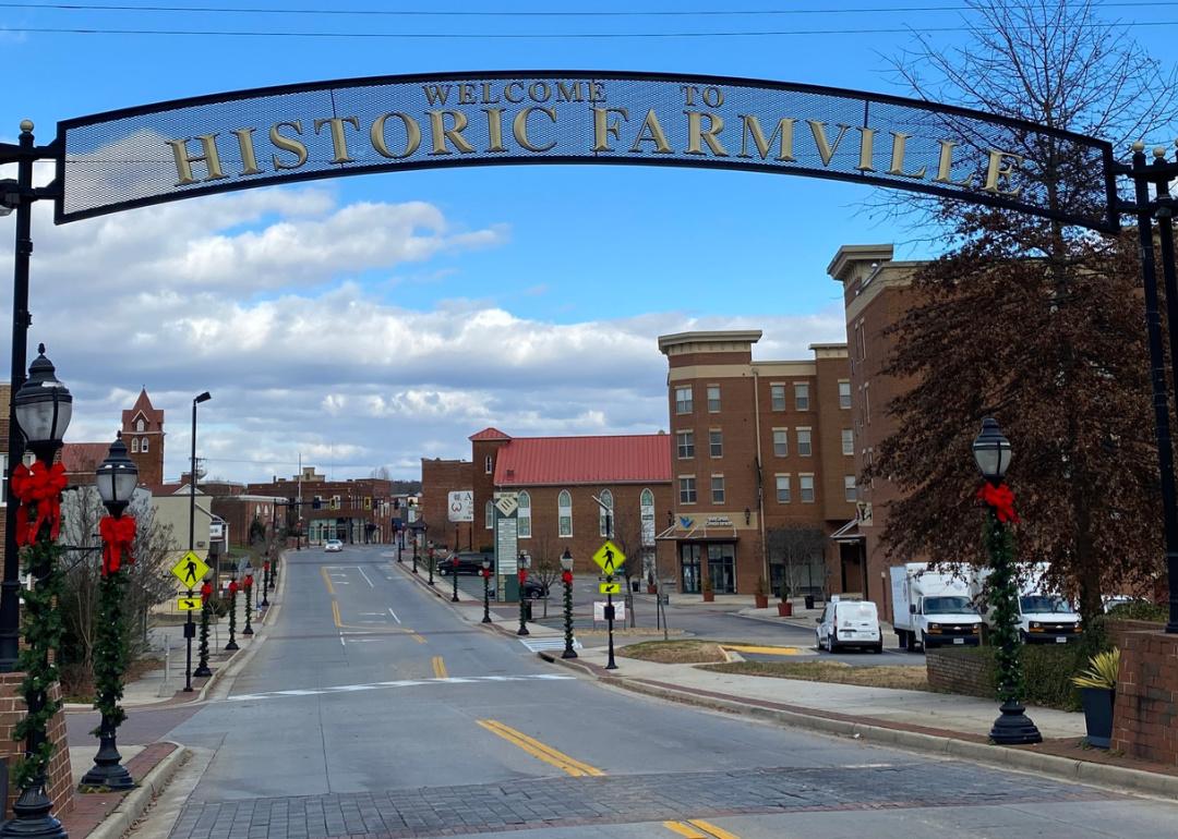
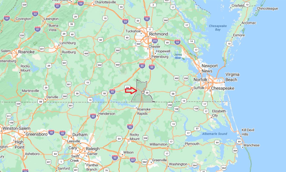
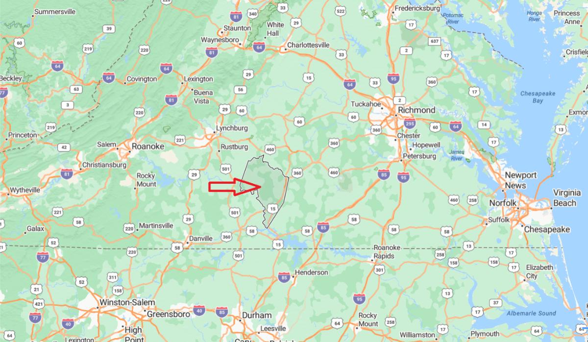
#50. Prince Edward County (tie)
– Life expectancy: 75.0 years
— 3.1 years lower than the state average
About
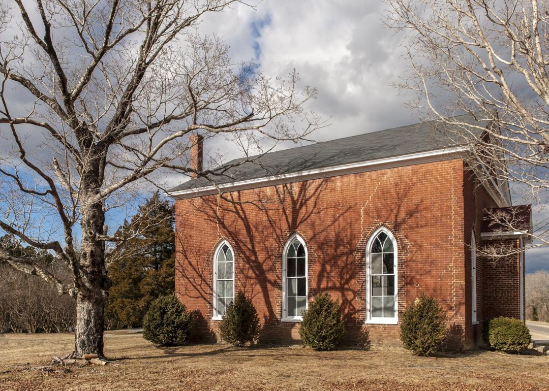
Prince Edward County is a historically rich and predominantly rural community centered around its largest town, Farmville. The county blends agricultural heritage with educational and cultural institutions, including the presence of Longwood University and Hampden-Sydney College. These colleges contribute to a vibrant local atmosphere and support a range of community events, arts programs, and small businesses.
The area is known for its quiet landscapes, family farms, and tight-knit communities. Outdoor recreation is abundant, with opportunities for hiking, fishing, and boating at nearby parks and lakes. The local economy is supported by a mix of agriculture, education, and light industry, offering a stable and balanced environment. Prince Edward County maintains a strong sense of identity rooted in tradition, education, and small-town life.
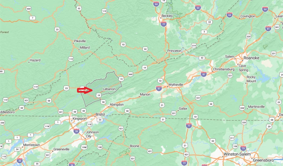
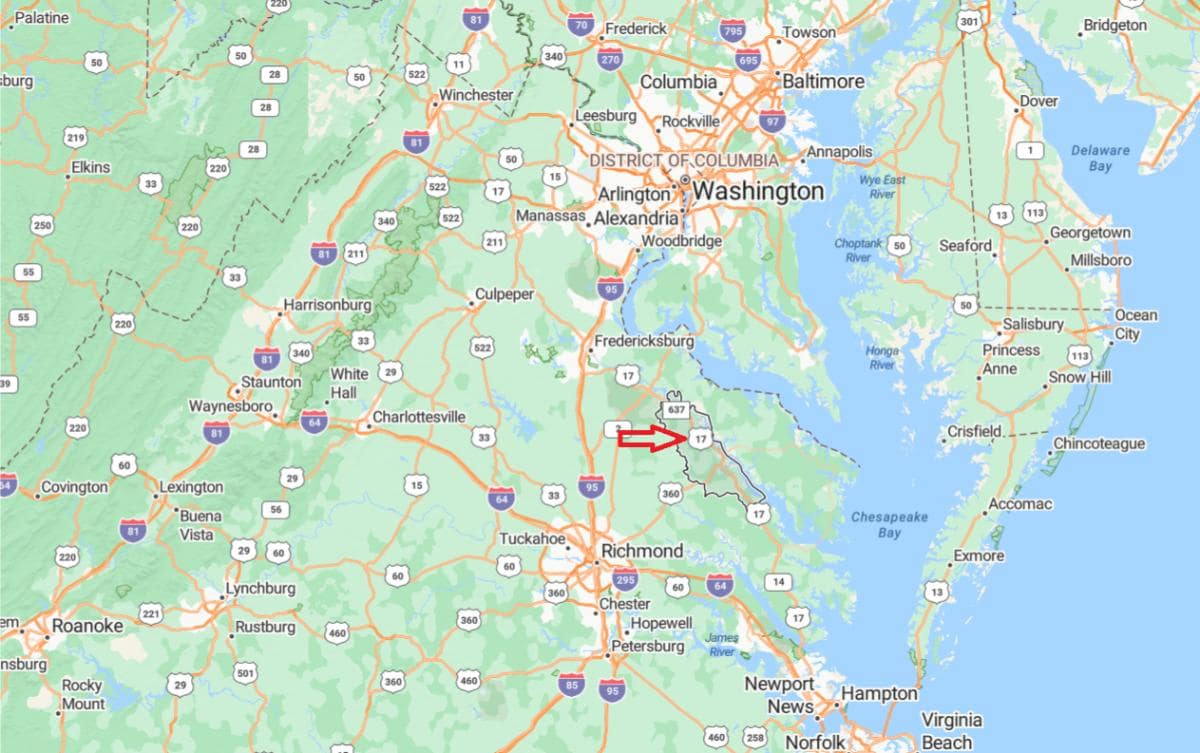
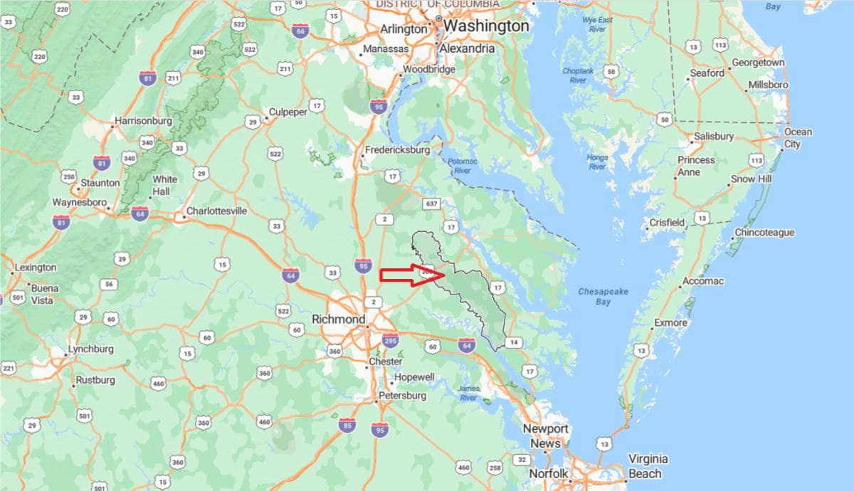
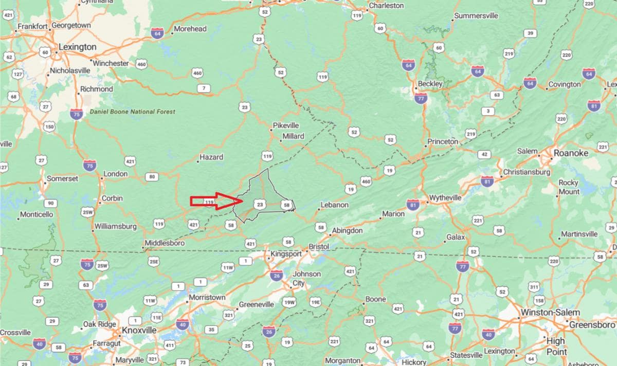
Where is Prince Edward County
Prince Edward County is located in south-central Virginia, roughly 60 miles southwest of Richmond and about 50 miles east of Lynchburg. It sits within Virginia’s Piedmont region, characterized by rolling hills, forests, and farmland.
The county is bordered by Buckingham County to the north, Cumberland to the northeast, and Charlotte and Lunenburg counties to the south. Its county seat, Farmville, is the largest town and serves as a commercial and cultural center for the surrounding area. The county’s location places it within driving distance of larger cities while retaining a distinctly rural character.
#48. Newport News (tie)
– Life expectancy: 74.6 years
— 3.5 years lower than the state average
About
Newport News, located in southeastern Virginia along the James River and Chesapeake Bay, is a vibrant city with deep maritime and military roots. Anchored by the sprawling Newport News Shipbuilding—the largest industrial employer in the region—the city is a key center for naval ship construction and repair. Its economy is also supported by defense, aerospace, port operations, and a growing presence in logistics and advanced manufacturing.
Culturally, Newport News offers a rich blend of historical sites, parks, and community arts, with attractions like the Mariners’ Museum, historic sites such as Endview Plantation, and citywide public art. The city is home to excellent parkland including Newport News Park, extensive bike and hiking trails, and waterfront recreation along the James River. With ongoing investments in infrastructure, downtown development, and educational initiatives, Newport News continues to grow as a balanced blend of history, industry, and quality of life.
Where is Newport News?
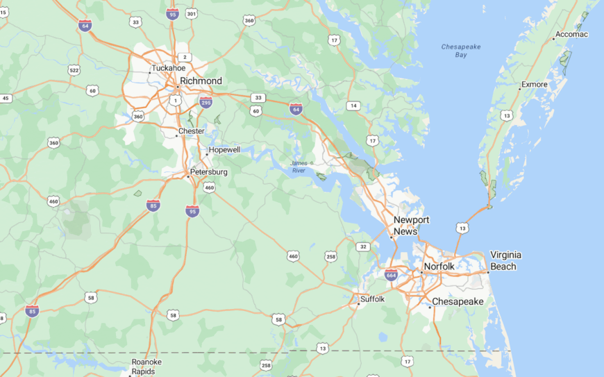
Newport News is an independent city in southeastern Virginia, located along the northern shore of the James River near its entrance to the Chesapeake Bay. It is part of the Hampton Roads metropolitan area and lies about 25 miles north of Norfolk and 70 miles southeast of Richmond. Major highways like Interstate 64 and U.S. Route 17 provide regional access.
The city is bordered by Hampton, York County, and the James River, which separates it from Isle of Wight County. Newport News is known for its shipbuilding industry, military facilities, and historical significance. With a population of around 185,000, it serves as a key economic and transportation hub in coastal Virginia.
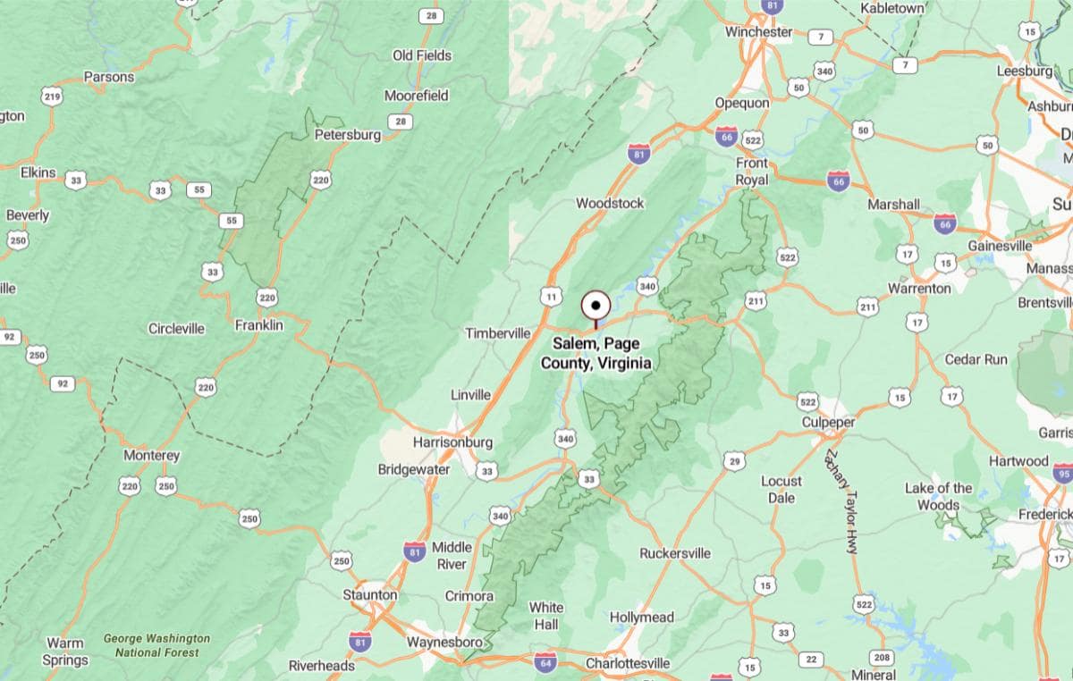
#48. Page County (tie)
– Life expectancy: 74.6 years
— 3.5 years lower than the state average
About
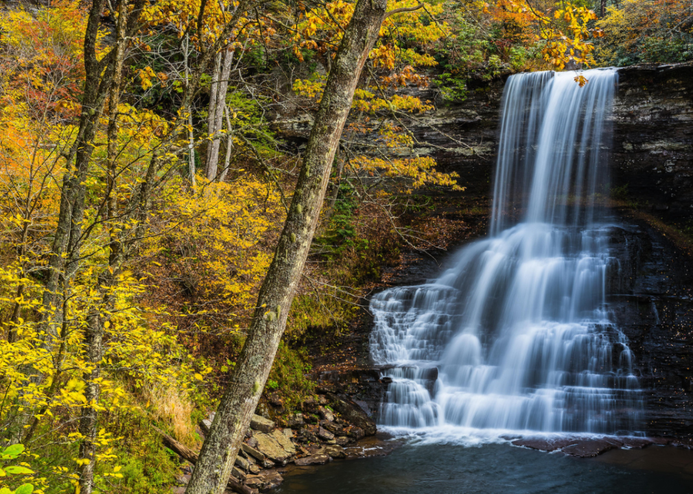
Page County, Virginia, is nestled in the scenic Page Valley between the Blue Ridge and Massanutten mountain ranges. The county seat, Luray, is a charming small town known for Luray Caverns and its proximity to Shenandoah National Park. The local economy blends tourism, agriculture, and small businesses, with recreation and lodging playing key roles in community life.
Outdoor adventure is central to the county’s appeal, offering boating and fishing on the South Fork of the Shenandoah River and hiking along Skyline Drive. Rural communities like Stanley and Shenandoah add cultural depth with local festivals, crafts, and traditions. With a focus on preserving natural landscapes and historic heritage, Page County maintains its rural charm while supporting sustainable growth.
Where is Page County?
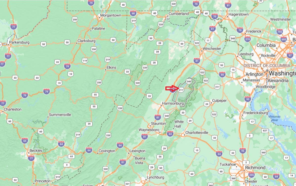
Page County is located in the Shenandoah Valley region of northwestern Virginia, between the Blue Ridge and Massanutten mountain ranges. The county seat is Luray, which is about 90 miles west of Washington, D.C., and accessible via U.S. Route 211 and U.S. Route 340. The county spans approximately 314 square miles of mostly rural and scenic terrain.
It is bordered by Shenandoah, Warren, Rappahannock, Madison, Greene, and Rockingham counties. Page County is known for natural attractions like the Luray Caverns and its access to Shenandoah National Park and Skyline Drive. With a population of around 23,000, it offers a quiet, mountainous setting popular with nature lovers and tourists.
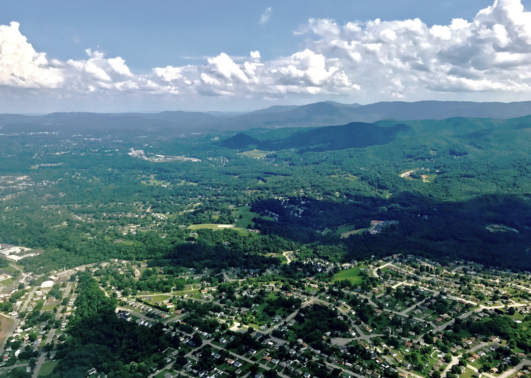
#45. Salem (tie)
– Life expectancy: 74.5 years
— 3.6 years lower than the state average
About
Salem, Virginia, is an independent city nestled in the Roanoke Valley of southwest Virginia, surrounded by the scenic Blue Ridge Mountains. Known for its small-town charm and vibrant community spirit, Salem serves as a cultural and economic hub with a strong focus on education, healthcare, and public service. The city is home to Roanoke College, a respected liberal arts institution that adds energy and diversity to the area.
Salem also boasts a rich history, walkable downtown, and a calendar full of local events, including the popular Salem Fair and a variety of sports and music festivals. Its location provides easy access to outdoor activities such as hiking, fishing, and kayaking along the Roanoke River and in nearby natural preserves. With a blend of historic character, natural beauty, and modern amenities, Salem offers residents and visitors a high quality of life in a close-knit community setting.
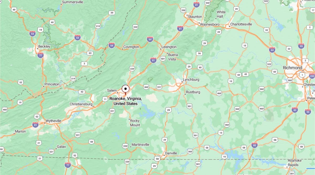
Where is Salem?
Salem is an independent city in western Virginia, located in the Roanoke Valley between the Blue Ridge and Allegheny Mountains. It lies adjacent to the city of Roanoke and about 115 miles west of Lynchburg. Major routes like Interstate 81 and U.S. Route 460 run through Salem, providing strong regional access.
The city is surrounded by Roanoke County and serves as a key part of the Roanoke metropolitan area. Salem is home to Roanoke College and known for its sports venues and historic charm. With a population of around 25,000, it offers a mix of small-city living and scenic mountain surroundings.

#45. Brunswick County (tie)
– Life expectancy: 74.5 years
— 3.6 years lower than the state average
About
Brunswick County, Virginia, is known for its strong agricultural heritage and historical significance. The area is a hub for farming and timber production, with generations of families maintaining deep ties to the land. Community events and local traditions reflect a strong sense of identity rooted in rural values.
The county features a mix of historic architecture, scenic countryside, and a relaxed pace of life. It is also home to educational institutions and civic organizations that contribute to community growth and cohesion. Residents take pride in their heritage while maintaining a welcoming, small-town atmosphere.
Where is Brunswick County?
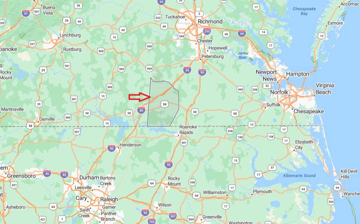
Brunswick County is located in the southern region of Virginia, approximately 78 miles southwest of Richmond, the state capital. It lies near the North Carolina border and is traversed by major highways including Interstate 85. The county spans a largely rural area with small towns like Lawrenceville serving as local centers.
From Petersburg, Virginia, Brunswick County is about 60 miles south, making it accessible for those traveling from the central part of the state. It is also situated roughly 110 miles north of Raleigh, North Carolina, providing regional connectivity between two major states. The area is known for its historical roots, agriculture, and scenic countryside.
You may also like: How syringe exchanges in Virginia reduce the spread of disease
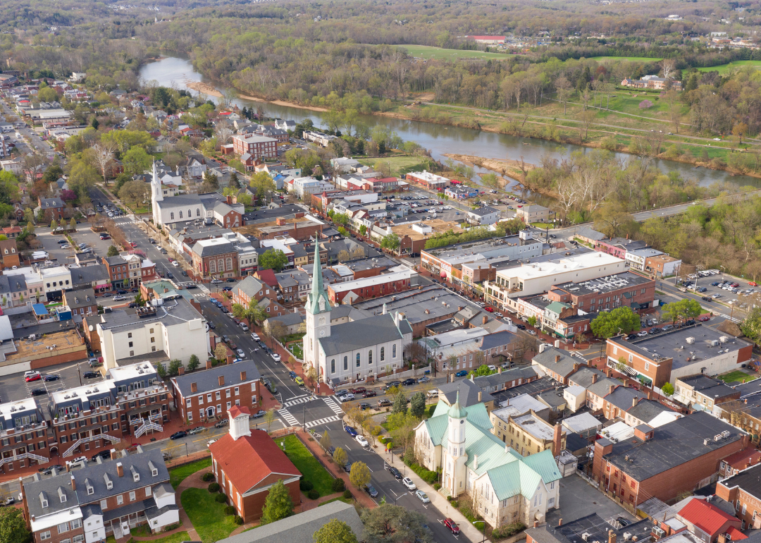
#45. Fredericksburg (tie)
– Life expectancy: 74.5 years
— 3.6 years lower than the state average
About
Fredericksburg, Virginia, blends colonial-era charm with a vibrant modern culture shaped by its deep historical roots. The city preserves its heritage through well-maintained architecture, battlefields, and museums that highlight its role in American history. Local festivals, art galleries, and community markets reflect a thriving cultural scene.
The area offers a balance of urban conveniences and scenic beauty, with parks, trails, and rivers adding to its appeal. Education and entrepreneurship are key drivers, supported by a diverse population and strong civic spirit. Residents enjoy a close-knit atmosphere with easy access to recreational and cultural amenities.
Where is Fredericksburg?
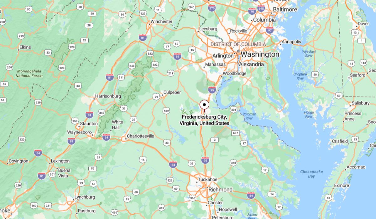
Fredericksburg, Virginia is situated in the northeastern part of the state, approximately 53 miles south of Washington, D.C. along Interstate 95. It lies between the nation’s capital and Richmond, making it a midpoint for commuters and travelers. The city is located in the northern part of the Piedmont region, close to the Rappahannock River.
From Richmond, Virginia, Fredericksburg is about 59 miles north, offering convenient access to both metropolitan areas. It is also around 33 miles northeast of Culpeper, connecting various parts of central Virginia. Its location has made it historically significant, especially during the Civil War, due to its strategic placement between North and South.
🔥 Would you like to save this?
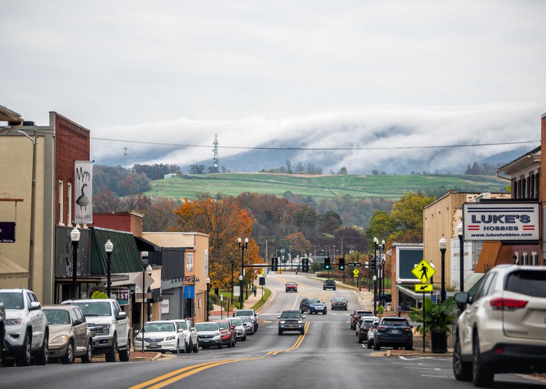
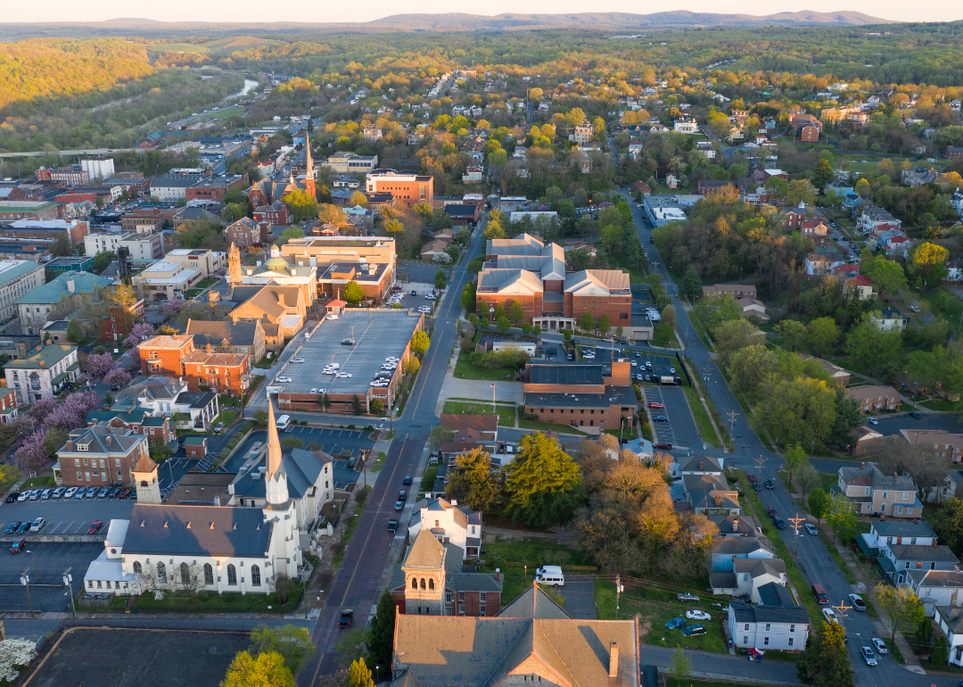
#44. Waynesboro
– Life expectancy: 74.4 years
— 3.7 years lower than the state average
About
Waynesboro, Virginia is a historic city shaped by its industrial roots and 19th-century development around railroads and ironworks. The downtown area showcases preserved architectural styles such as Federal and Italianate, alongside landmarks like the Plumb House Museum and cultural institutions. Recent revitalization efforts have turned former industrial spaces into vibrant hubs for art, music, and local business.
The city is surrounded by natural beauty, offering easy access to hiking trails, rivers, and national parks. Outdoor recreation is a central part of life, with activities like fly-fishing, paddling, and nature walks widely enjoyed. A strong arts community, diverse culinary scene, and annual festivals contribute to Waynesboro’s lively, close-knit atmosphere.
Where is Waynesboro?
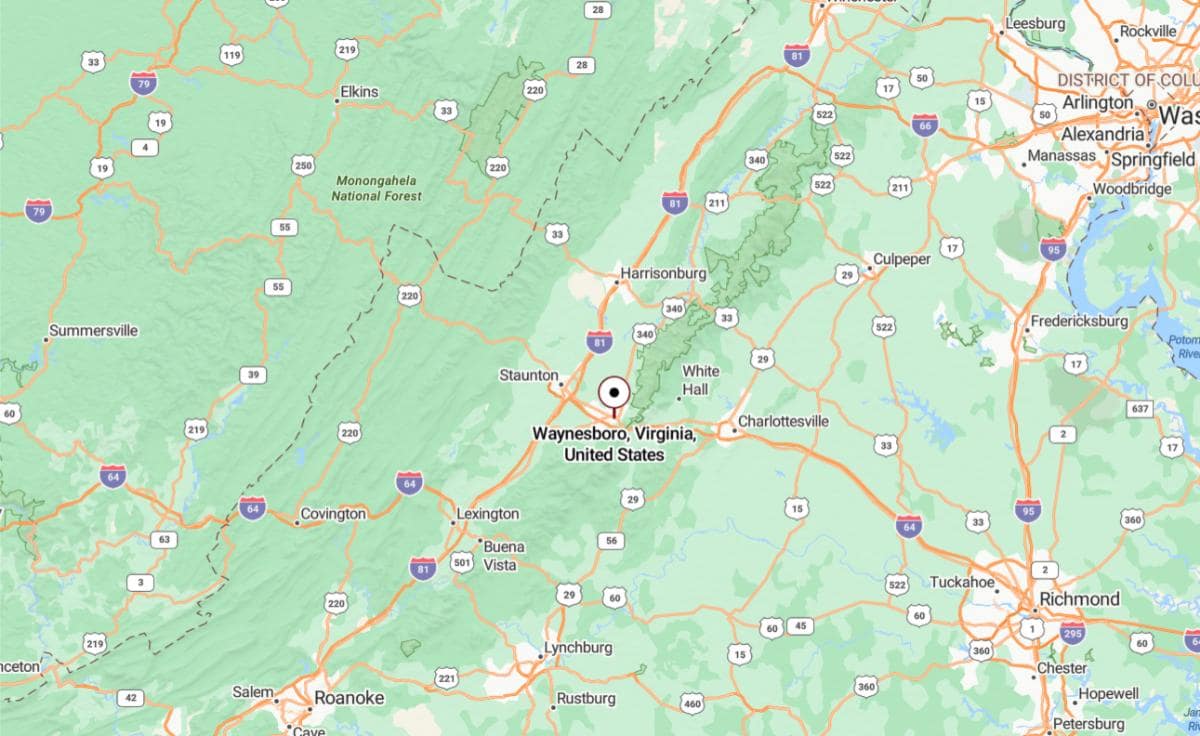
Waynesboro, Virginia is located in the Shenandoah Valley, approximately 27 miles west of Charlottesville via Interstate 64. It lies just 14 miles east of Staunton, making it part of a regional corridor along the Blue Ridge Mountains. The city sits near Rockfish Gap, a natural passage between the mountains and the valley.
From Richmond, Waynesboro is about 115 miles west, offering access to the Shenandoah National Park and the Blue Ridge Parkway. It is also roughly 150 miles southwest of Washington, D.C., placing it within driving distance of major metropolitan areas. Its position makes it a key point for travel, commerce, and scenic exploration in western Virginia.
#42. Lynchburg (tie)
– Life expectancy: 74.1 years
— 4.0 years lower than the state average
About
Lynchburg, Virginia is a city with a rich historical legacy, once a major hub for commerce, transportation, and industry in the 19th century. Its downtown district features restored warehouses, historic churches, and cultural landmarks that reflect its past. The city balances preservation with progress through revitalization projects and a growing arts scene.
Home to several colleges and universities, Lynchburg has a youthful energy and strong academic influence. Green spaces, trails, and riverfront parks offer residents ample opportunities for outdoor recreation. A blend of tradition and innovation defines the city’s character, making it both historically significant and forward-looking.
Where is Lynchburg?
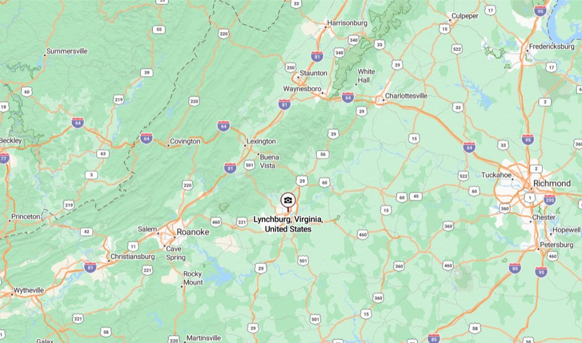
Lynchburg, Virginia is located in the foothills of the Blue Ridge Mountains in central Virginia, about 53 miles east of Roanoke via U.S. Route 460. It lies along the James River and serves as a regional hub for surrounding rural areas. The city’s elevated position has earned it the nickname “The Hill City.”
From Richmond, Lynchburg is approximately 113 miles west, making it accessible by both highway and rail. It is also about 180 miles southwest of Washington, D.C., placing it within reach of the nation’s capital while still maintaining a more rural character. Its location provides convenient access to mountain recreation and central Virginia’s cultural centers.
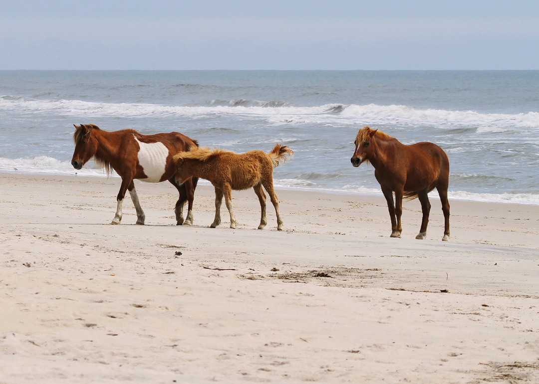
#42. Accomack County (tie)
– Life expectancy: 74.1 years
— 4.0 years lower than the state average
About
Accomack County, Virginia is known for its agricultural roots, maritime culture, and rural charm. It has a long history tied to farming, fishing, and watermen traditions that continue to shape local life. Small towns and villages across the county maintain close-knit communities with a strong sense of heritage.
The landscape features open fields, coastal wetlands, and access to waterways that support both industry and recreation. Wildlife preserves and natural refuges offer opportunities for birdwatching, boating, and exploring unspoiled environments. Residents value the quiet pace, scenic beauty, and connection to the land and sea.
Where is Accomack County?
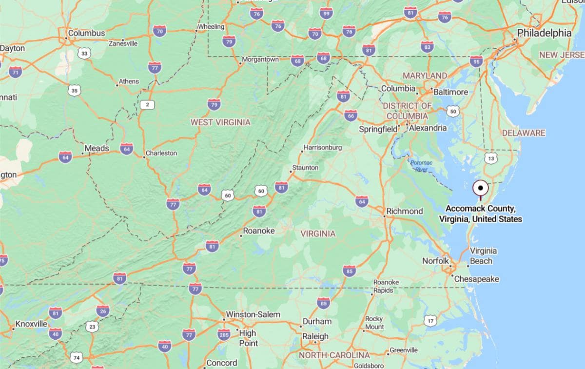
Accomack County, Virginia is located on the Eastern Shore of the state, bordered by the Chesapeake Bay to the west and the Atlantic Ocean to the east. It is approximately 78 miles north of Virginia Beach via U.S. Route 13, running along the narrow peninsula. The county includes coastal towns like Onancock and Chincoteague, known for their waterfront charm and wildlife areas.
From Norfolk, Accomack County lies about 90 miles northeast, making it a relatively remote yet accessible destination. It is also roughly 140 miles southeast of Washington, D.C., reached by crossing the Chesapeake Bay Bridge-Tunnel and continuing north along the shore. Its location places it within a unique coastal environment separate from mainland Virginia.
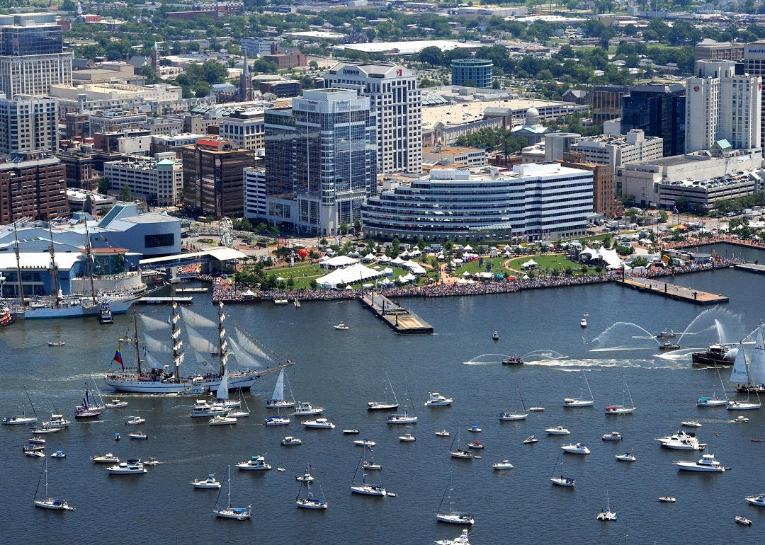
#40. Norfolk (tie)
– Life expectancy: 74.0 years
— 4.1 years lower than the state average
About
Norfolk, Virginia is a vibrant city with deep military, maritime, and cultural roots. It features a dynamic downtown, historic neighborhoods, and a strong presence of naval and shipping industries. Museums, theaters, and music venues contribute to a thriving arts and cultural scene.
Waterfront access shapes much of the city’s lifestyle, offering harbors, marinas, and scenic views. Parks, trails, and festivals provide year-round recreation and community engagement. Norfolk blends historic significance with modern growth, creating a diverse and energetic urban atmosphere.
Where is Norfolk?
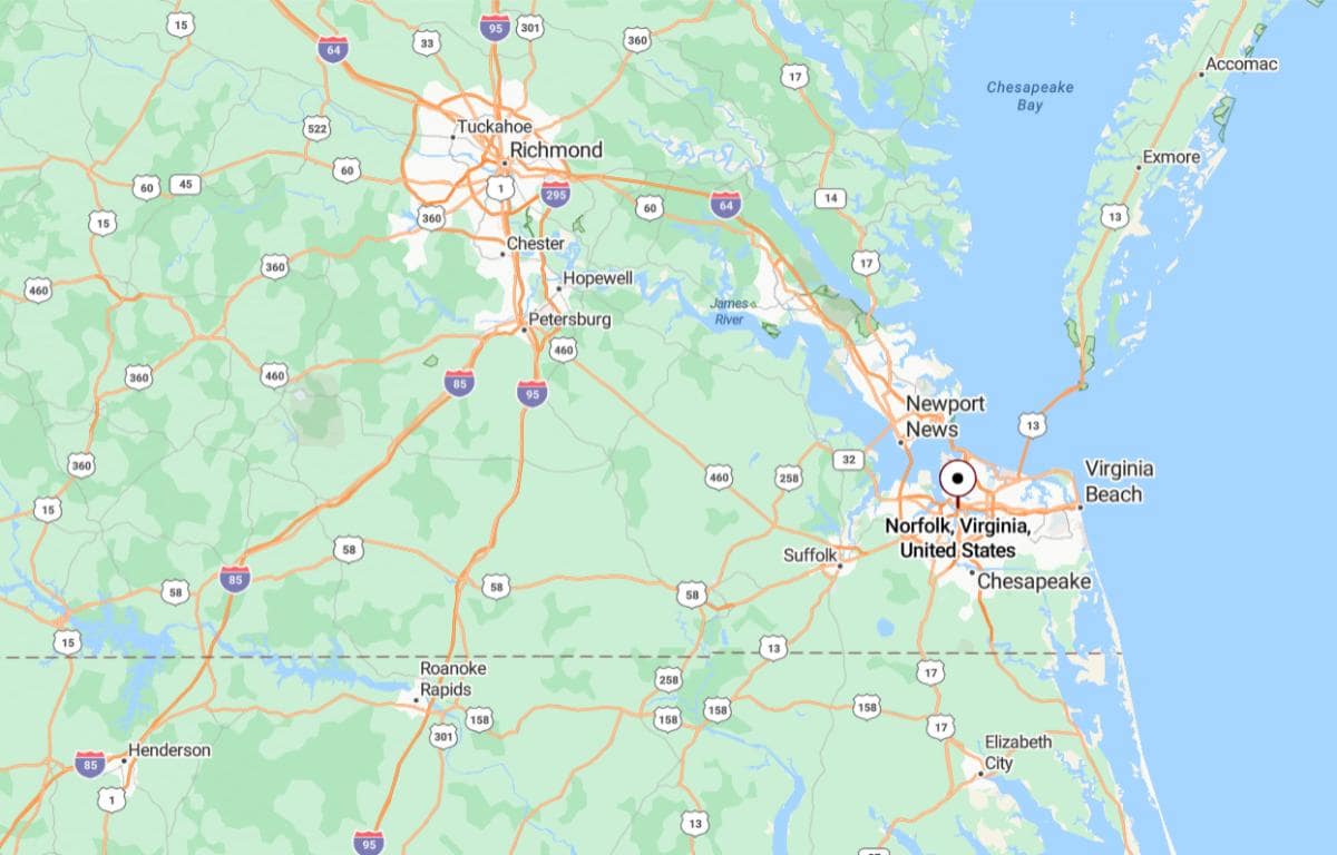
Norfolk, Virginia is located in the southeastern corner of the state, along the shores of the Chesapeake Bay and the Elizabeth River. It is approximately 19 miles west of Virginia Beach, connected by major highways and bridges. As part of the Hampton Roads metropolitan area, it serves as a key port and naval center.
From Richmond, Norfolk is about 93 miles southeast, making it accessible via Interstate 64. It is also roughly 200 miles south of Washington, D.C., providing a connection between coastal Virginia and the nation’s capital. Its coastal location plays a major role in transportation, defense, and commerce in the region.
You may also like: These 10 car insurers have the highest market share in Virginia
#40. Middlesex County (tie)
– Life expectancy: 74.0 years
— 4.1 years lower than the state average
About
Middlesex County, Virginia is a rural community known for its deep ties to agriculture, boating, and traditional craftsmanship. Its heritage is reflected in local museums, historic buildings, and long-standing family farms. Quiet towns and scenic backroads preserve the area’s small-town character and relaxed pace.
The county’s waterways play a central role in both economy and recreation, supporting fishing, sailing, and waterfront living. Marinas, boatyards, and seasonal festivals highlight the maritime culture that defines much of daily life. Residents appreciate the peaceful setting, natural beauty, and strong sense of local identity.
Where is Middlesex County?
Middlesex County, Virginia is located in the eastern part of the state along the western shore of the Chesapeake Bay. It lies approximately 63 miles east of Richmond, accessible via U.S. Route 33 and Route 17. The county includes waterfront communities such as Urbanna, known for boating and coastal scenery.
From Fredericksburg, Middlesex County is about 78 miles southeast, offering a quiet rural escape from urban centers. It is also around 125 miles south of Washington, D.C., placing it within reach of the capital while maintaining a coastal, small-town atmosphere. Its location makes it a popular destination for recreation and seasonal retreats.
#37. Northampton County (tie)
– Life expectancy: 73.9 years
— 4.2 years lower than the state average
About
Northampton County, Virginia is a place where history, agriculture, and coastal living come together. Generations of farming and fishing families have shaped its identity, with traditions still visible in daily life. Historic architecture, quiet roads, and family-run businesses add to its enduring charm.
Natural beauty surrounds the area, with bays, creeks, and wildlife habitats offering scenic and recreational opportunities. The county supports conservation efforts and eco-tourism alongside its working landscapes. A strong sense of community, heritage, and connection to the environment defines its way of life.
Where is Northampton County?
Northampton County, Virginia is located on the southern end of the Eastern Shore peninsula, bordered by the Chesapeake Bay and the Atlantic Ocean. It is approximately 45 miles north of Virginia Beach, connected via the Chesapeake Bay Bridge-Tunnel. The county includes coastal towns like Cape Charles, offering waterfront views and historic charm.
From Norfolk, Northampton County is about 42 miles northeast, making it accessible for day trips or coastal escapes. It is also roughly 155 miles southeast of Washington, D.C., placing it within reach of the Mid-Atlantic’s major metropolitan areas. Its position on the narrow peninsula gives it a unique mix of seclusion and accessibility.

🔥 Would you like to save this?
#37. Scott County (tie)
– Life expectancy: 73.9 years
— 4.2 years lower than the state average
About
Scott County, Virginia is a rural region steeped in Appalachian heritage and natural beauty. Its history is rooted in agriculture, early frontier settlement, and strong musical traditions. Local landmarks and festivals reflect a deep pride in cultural identity and community life.
Forests, rivers, and mountain ridges define the landscape, offering abundant opportunities for hiking, fishing, and outdoor recreation. The county is home to scenic parks and historic trails that draw visitors and locals alike. Life in Scott County is shaped by a close connection to nature, family traditions, and a slower, grounded pace.
Where is Scott County?
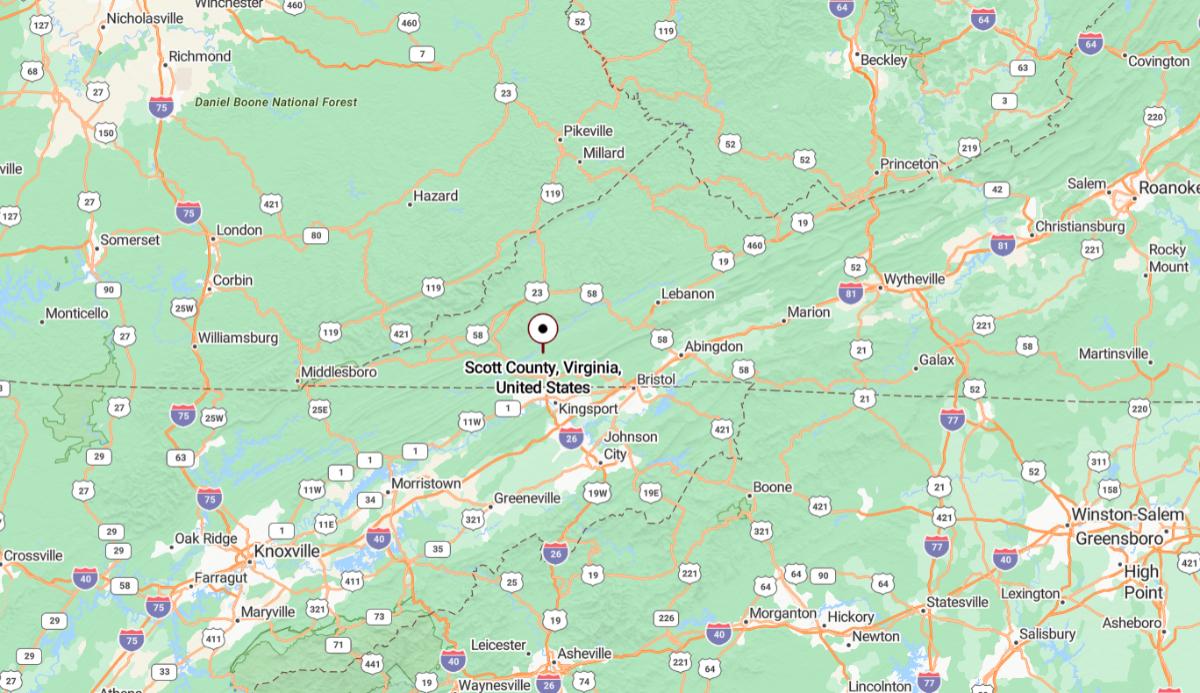
Scott County, Virginia is located in the far southwestern corner of the state, within the Appalachian Highlands. It is approximately 24 miles southwest of Kingsport, Tennessee, forming part of the Tri-Cities region. The county is characterized by its mountainous terrain and rural communities.
From Roanoke, Scott County is about 160 miles southwest, accessible via a combination of Interstate and U.S. highways. It also lies roughly 380 miles west of Richmond, placing it among the most distant counties from the state capital. Its location offers a gateway to Tennessee while reflecting the Appalachian culture and landscape.
#37. Mecklenburg County (tie)
– Life expectancy: 73.9 years
— 4.2 years lower than the state average
About
Mecklenburg County, Virginia is known for its agricultural heritage, lakeside culture, and historic towns. Generations of farming families and local businesses contribute to a strong, self-reliant community spirit. Architectural landmarks and cultural events reflect its blend of tradition and progress.
Recreational life centers around lakes, trails, and open spaces, making outdoor activities a central part of daily living. Fishing, boating, and festivals draw both locals and visitors throughout the year. The county offers a peaceful rural atmosphere balanced with opportunities for growth and connection.
Where is Mecklenburg County?
Mecklenburg County, Virginia is located in the south-central region of the state, bordering North Carolina. It is approximately 80 miles southwest of Richmond, accessible via U.S. Route 58 and Interstate 85. The county includes towns like South Hill and Clarksville, with the latter sitting on the shores of Buggs Island Lake.
From Raleigh, North Carolina, Mecklenburg County is about 75 miles north, making it part of the broader Virginia–North Carolina border corridor. It also lies roughly 150 miles south of Washington, D.C., offering a more rural and recreational setting. The county’s location supports both cross-state travel and access to lakeside activities.
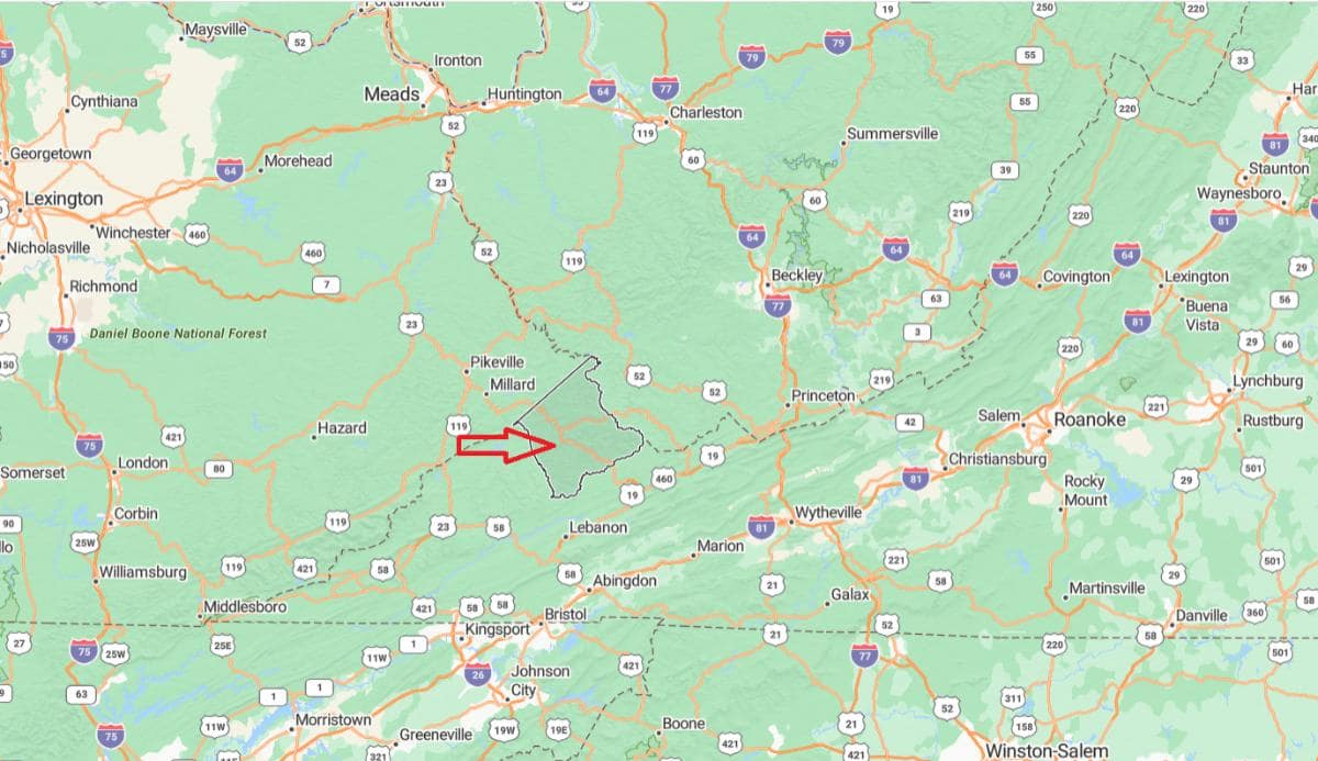
#34. Russell County (tie)
– Life expectancy: 73.8 years
— 4.3 years lower than the state average
About
Russell County, Virginia is a mountainous region with strong roots in coal mining, farming, and Appalachian culture. Its communities reflect a history of hard work, resilience, and deep family ties. Local traditions are preserved through music, crafts, and regional festivals.
The county is rich in natural beauty, with rivers, forests, and trails offering a haven for outdoor enthusiasts. Conservation areas and scenic overlooks provide quiet spaces for hiking, fishing, and wildlife observation. Life in Russell County is grounded in heritage, nature, and a deep sense of belonging.
Where is Russell County?
Russell County, Virginia is located in the southwestern part of the state, nestled in the Appalachian Mountains. It is approximately 35 miles northwest of Abingdon, a nearby regional center connected by U.S. Route 19. The county is known for its mountainous landscape, rural communities, and natural beauty.
From Roanoke, Russell County lies about 145 miles southwest, offering a remote and scenic destination within Virginia’s highlands. It is also roughly 370 miles west of Richmond, placing it far from the state’s eastern urban centers. Its location provides access to outdoor recreation and a quiet Appalachian setting.
You may also like: Counties where homes are selling the fastest in Virginia
#34. Pulaski County (tie)
– Life expectancy: 73.8 years
— 4.3 years lower than the state average
About
Pulaski County, Virginia is a community shaped by its industrial past, natural beauty, and small-town character. Manufacturing and railroads played a key role in its development, and traces of that legacy remain in local landmarks. Historic districts, schools, and civic organizations foster a strong sense of local pride.
The county offers scenic landscapes with access to lakes, rivers, and mountain trails that support outdoor recreation year-round. Parks, festivals, and community events bring residents together and highlight the area’s cultural spirit. Pulaski County blends heritage and nature with a focus on community connection and steady growth.
Where is Pulaski County?
Pulaski County, Virginia is situated in the southwestern region of the state, within the New River Valley. It is approximately 23 miles southwest of Christiansburg, connected via Interstate 81. The county includes the town of Pulaski and lies along the New River, offering scenic mountain and river views.
From Roanoke, Pulaski County is about 52 miles southwest, making it easily accessible by highway. It is also roughly 240 miles west of Richmond, placing it well within Virginia’s Appalachian foothills. The area is known for its blend of rural charm, manufacturing history, and outdoor recreation.
#34. Essex County (tie)
– Life expectancy: 73.8 years
— 4.3 years lower than the state average
About
Essex County, Virginia is a quiet, rural area with deep roots in farming, fishing, and colonial history. Historic homes, churches, and landmarks reflect a legacy that stretches back centuries. Community traditions and local pride remain central to daily life.
The county’s landscape includes open fields, riverbanks, and wooded areas that support both agriculture and recreation. Outdoor activities like boating, hunting, and hiking are common and cherished by residents. Life in Essex County is marked by its peaceful atmosphere, strong heritage, and enduring connection to the land.
Where is Essex County?
🔥 Would you like to save this?
Essex County, Virginia is located in the eastern part of the state, along the Rappahannock River. It is approximately 47 miles northeast of Richmond, accessible via U.S. Route 360. The county seat, Tappahannock, serves as a regional hub with historical and commercial significance.
From Fredericksburg, Essex County is about 43 miles southeast, offering a connection between the Northern Neck and central Virginia. It is also roughly 88 miles south of Washington, D.C., making it a reachable destination from the capital. The county’s location provides a blend of rural character and riverfront access.
#31. Nottoway County (tie)
– Life expectancy: 73.7 years
— 4.4 years lower than the state average
About
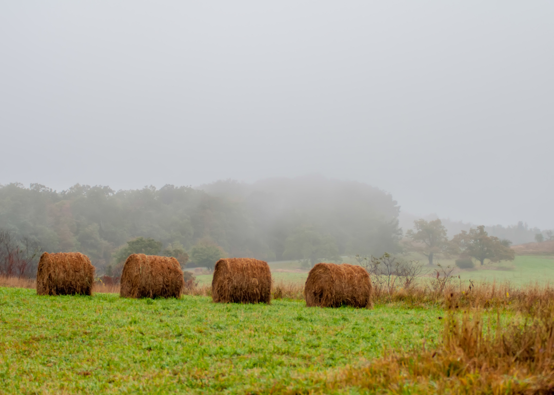
Nottoway County, Virginia is a rural community known for its agricultural traditions, historical roots, and close-knit towns. Its past is reflected in preserved buildings, landmarks, and long-standing local customs. The area maintains a quiet, grounded atmosphere shaped by generations of hardworking families.
Rolling farmland, woodlands, and small lakes define the county’s natural setting, offering space for both work and recreation. Hunting, fishing, and seasonal events are important parts of the local lifestyle. Nottoway County values its heritage, simplicity, and strong sense of place.
Where is Nottoway County?
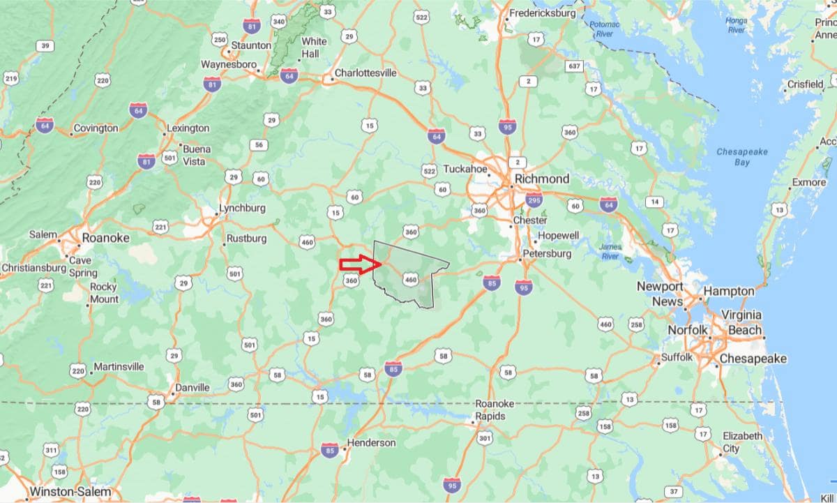
Nottoway County, Virginia is located in the south-central region of the state, within Virginia’s Piedmont. It is approximately 60 miles southwest of Richmond, accessible via U.S. Route 460. The county includes small towns like Blackstone and Crewe, known for their historical and military connections.
From Lynchburg, Nottoway County lies about 65 miles east, forming part of the corridor between central and southern Virginia. It is also roughly 160 miles south of Washington, D.C., placing it within reach of the broader Mid-Atlantic region. Its central location offers both rural charm and strategic access to larger urban centers.
#31. Lunenburg County (tie)
– Life expectancy: 73.7 years
— 4.4 years lower than the state average
About
Lunenburg County, Virginia is a rural area steeped in tradition, with a long-standing connection to agriculture and small-town life. Historic courthouses, churches, and family homesteads tell the story of generations rooted in the land. Community values and local pride are central to the county’s identity.
The landscape features open fields, pine forests, and quiet roads that support a peaceful, steady pace of living. Farming, hunting, and close community ties shape daily routines and seasonal events. Lunenburg County offers a blend of heritage, natural beauty, and enduring simplicity.
Where is Lunenburg County?
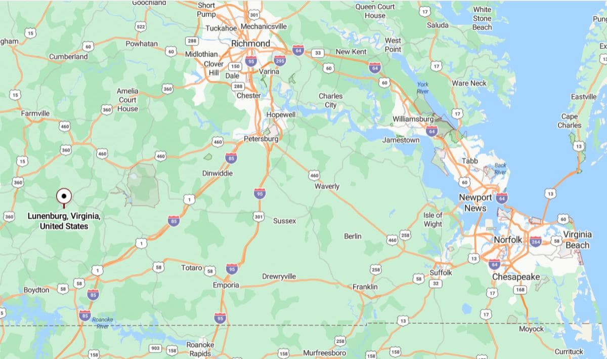
Lunenburg County, Virginia is located in the south-central part of the state, bordered by several rural counties. It is approximately 75 miles southwest of Richmond, reachable by U.S. Route 360. The county seat, Lunenburg, and nearby Victoria serve as local centers in this largely agricultural area.
From Lynchburg, Lunenburg County is about 70 miles southeast, offering access to central Virginia’s rural landscape. It is also roughly 170 miles south of Washington, D.C., placing it within driving distance of major metropolitan areas while maintaining a quiet, countryside character. Its position supports both farming activity and regional connectivity.
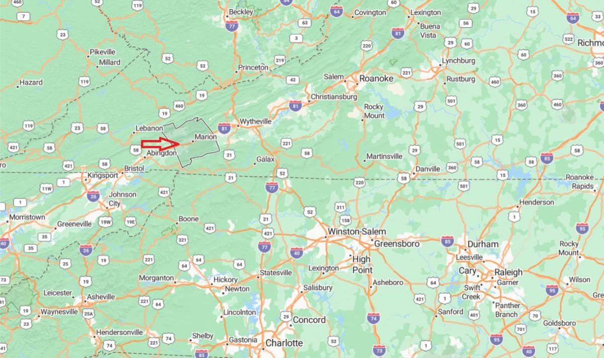
#31. Wythe County (tie)
– Life expectancy: 73.7 years
— 4.4 years lower than the state average
About
Wythe County, Virginia is a region known for its Appalachian heritage, industrial roots, and strong community traditions. Historic towns and landmarks reflect a legacy of craftsmanship, mining, and early American settlement. A sense of pride in local history and resilience is deeply woven into daily life.
The county’s natural setting includes rolling hills, rivers, and forested areas that invite outdoor exploration and recreation. Hiking, fishing, and seasonal festivals are popular among residents and visitors alike. Wythe County balances its rural charm with economic activity and a deep connection to its cultural past.
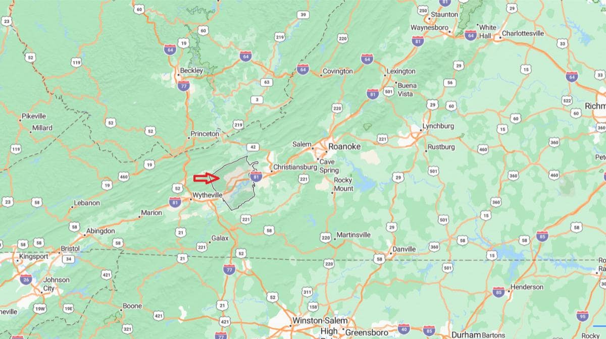
Where is Wythe County?
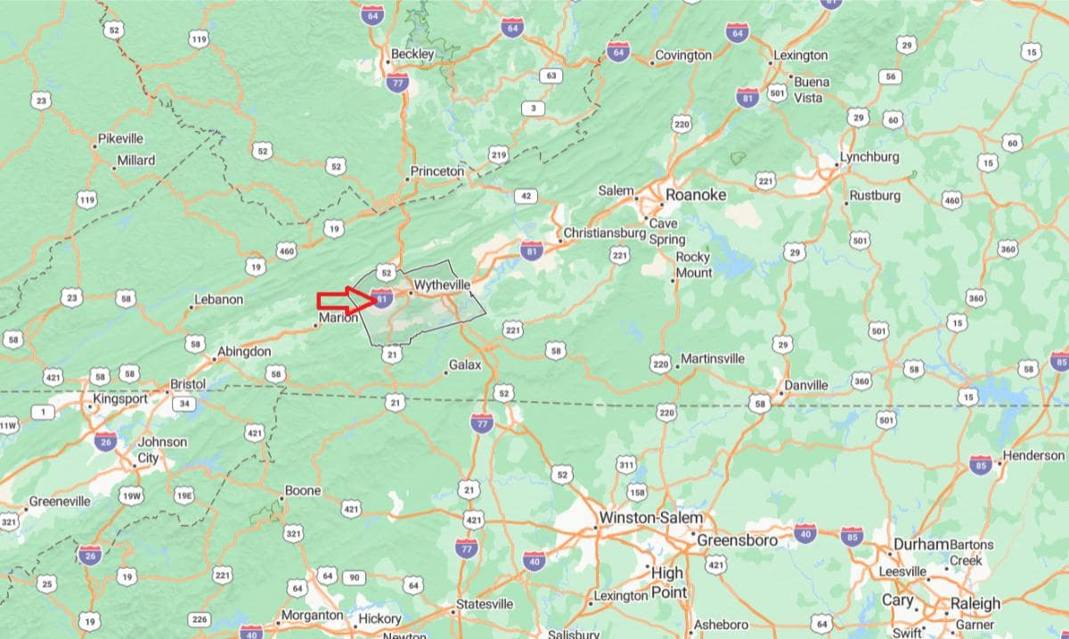
Wythe County, Virginia is located in the southwestern part of the state, where Interstates 77 and 81 intersect. It is approximately 30 miles northeast of Marion, making it part of the Appalachian Highlands region. The county seat, Wytheville, serves as a major transportation and service hub for the area.
From Roanoke, Wythe County is about 87 miles southwest, easily accessible via Interstate 81. It is also roughly 250 miles west of Richmond, placing it deep within Virginia’s mountain region. Its strategic location at the junction of two major highways enhances its role in regional travel and commerce.
You may also like: Best private colleges in Virginia
#29. Bristol (tie)
– Life expectancy: 73.6 years
— 4.5 years lower than the state average
About
Bristol, Virginia is a city rich in musical heritage, small-town character, and historical significance. It is widely celebrated as a birthplace of country music, with strong ties to Appalachian traditions and creative expression. The community blends this cultural legacy with a welcoming, tight-knit atmosphere.
The city features a vibrant downtown filled with live music venues, local shops, and arts festivals that reflect its creative energy. Outdoor spaces, parks, and nearby trails support an active lifestyle and community events. Bristol offers a unique mix of tradition, rhythm, and hometown pride.
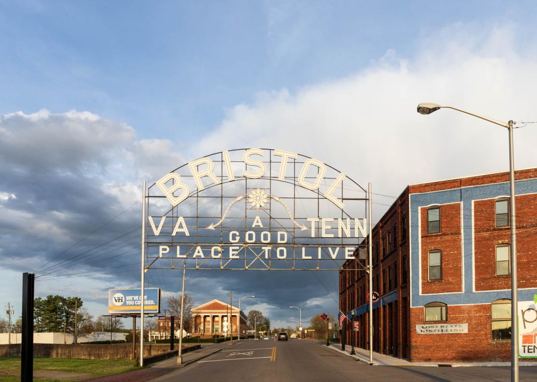
Where is Bristol?
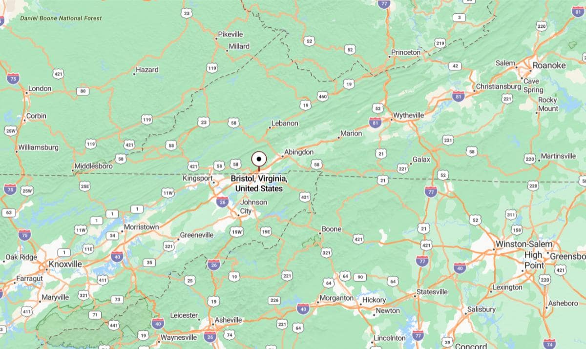
Bristol, Virginia is located in the far southwestern corner of the state, directly on the border with Tennessee. It is approximately 28 miles southwest of Abingdon, accessible via Interstate 81. The city is unique in that it shares its main street and name with Bristol, Tennessee.
From Roanoke, Bristol is about 145 miles southwest, following I‑81 through the Appalachian Mountains. It is also roughly 360 miles west of Richmond, placing it among Virginia’s most distant urban areas from the capital. Its border location makes it a cultural and economic gateway between Virginia and Tennessee.
#29. Alleghany County (tie)
– Life expectancy: 73.6 years
— 4.5 years lower than the state average
About
Alleghany County, Virginia is a mountain community shaped by its industrial past, scenic surroundings, and enduring local traditions. Its history includes railroads, paper mills, and small-town growth that have influenced generations of families. Historic architecture, schools, and community events highlight a strong sense of heritage.
The county is rich in natural beauty, with forests, rivers, and trails offering a peaceful setting for outdoor activities. Residents enjoy fishing, hiking, and seasonal festivals that bring people together year-round. Life in Alleghany County reflects a deep connection to nature, history, and community pride.
Where is Alleghany County?
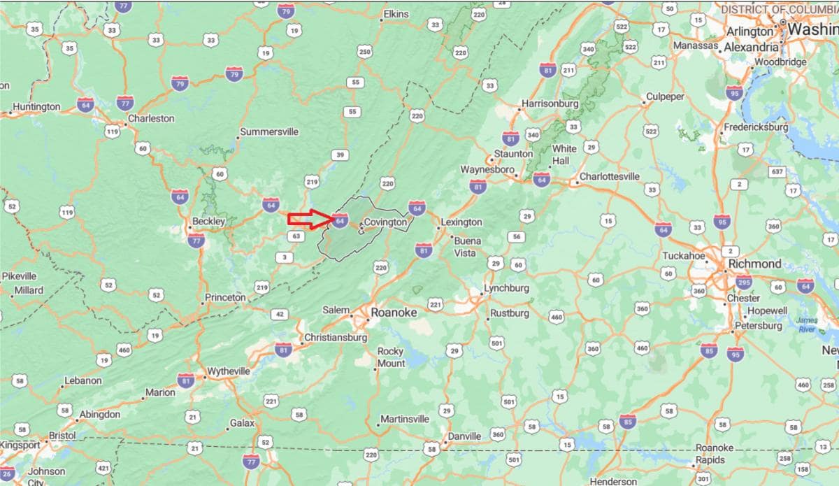
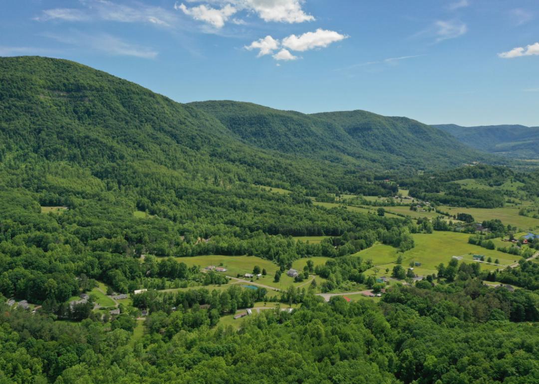
Alleghany County, Virginia is located in the west-central part of the state, nestled within the Allegheny Mountains. It is approximately 26 miles northwest of Lexington, accessible via Interstate 64 and U.S. Route 60. The county seat, Covington, serves as the primary urban center in the region.
From Roanoke, Alleghany County is about 56 miles northwest, offering a direct route through the mountainous terrain. It is also roughly 170 miles west of Richmond, placing it on the edge of Virginia’s Appalachian Highlands. The county’s location provides scenic landscapes and access to outdoor recreation in the national forest areas.
#28. Patrick County
– Life expectancy: 73.5 years
— 4.6 years lower than the state average
About
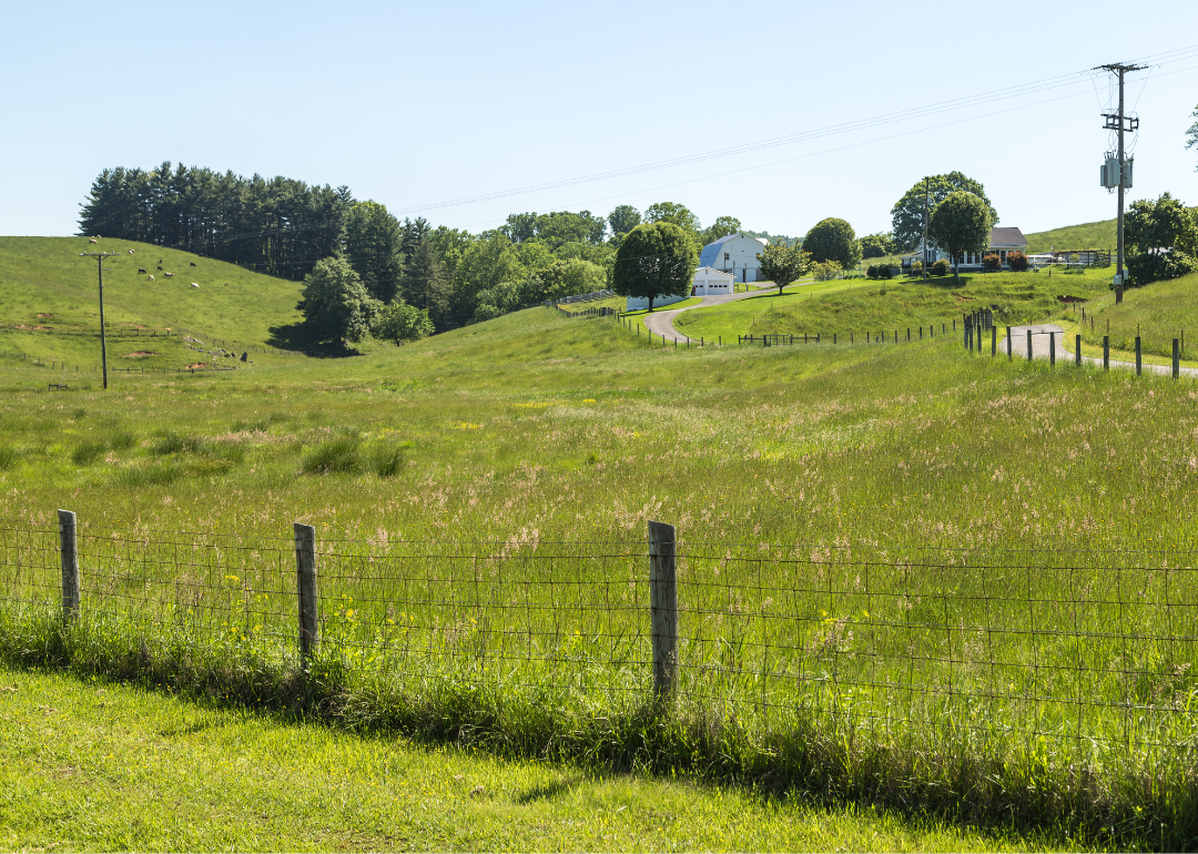
Patrick County, Virginia is a rural region known for its mountain landscapes, agricultural roots, and deep cultural traditions. Historic sites, family farms, and local music events reflect a strong Appalachian heritage. The community values simplicity, resilience, and close family ties.
Scenic roads, rivers, and trails offer opportunities for hiking, fishing, and nature appreciation. Annual festivals and craft fairs celebrate local talent and bring neighbors together. Patrick County blends natural beauty with a way of life grounded in history and community spirit.
Where is Patrick County?
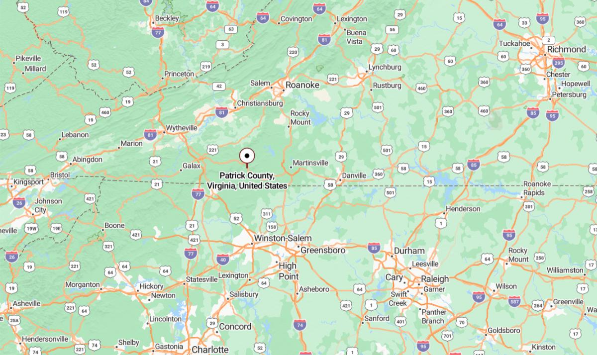
Patrick County, Virginia is located in the southern part of the state, along the North Carolina border in the Blue Ridge Mountains. It is approximately 61 miles southwest of Lynchburg, offering a mix of mountain terrain and rural farmland. The county seat, Stuart, lies near the Blue Ridge Parkway and is known for its scenic views.
From Roanoke, Patrick County is about 60 miles south, accessible via U.S. Route 220 and other regional roads. It is also roughly 205 miles southwest of Richmond, placing it within Virginia’s southern highlands. Its location provides a quiet, mountainous environment ideal for outdoor recreation and rural living.
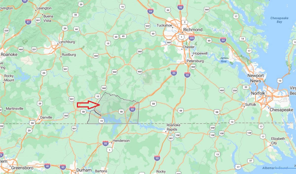
#27. Amelia County
– Life expectancy: 73.4 years
— 4.7 years lower than the state average
About
Amelia County, Virginia is a quiet rural community with a deep agricultural heritage and a strong sense of tradition. Historic courthouses, farms, and family-owned businesses reflect the county’s long-standing roots. The local culture emphasizes simplicity, hard work, and connection to the land.
Open fields, woodlands, and country roads define the landscape, offering a peaceful and steady pace of life. Residents enjoy hunting, farming, and participating in local events that foster unity and pride. Amelia County stands out for its timeless character and enduring community values.
Where is Amelia County?
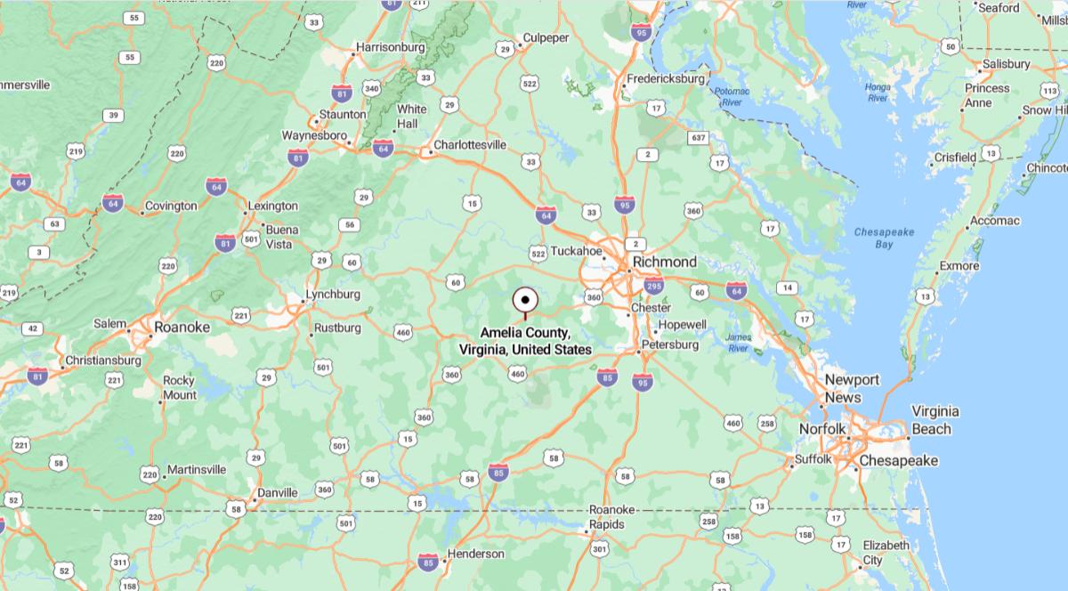
Amelia County, Virginia is located in the central part of the state, within the Piedmont region. It is approximately 37 miles southwest of Richmond, accessible via U.S. Route 360. The county seat, Amelia Court House, serves as the center of local government and commerce.
From Petersburg, Amelia County is about 30 miles west, making it part of the greater Richmond metropolitan area. It is also roughly 130 miles south of Washington, D.C., offering a balance between rural life and access to urban centers. Its location supports agriculture, small-town living, and regional connectivity.
#26. King and Queen County
– Life expectancy: 73.3 years
— 4.8 years lower than the state average
About
King and Queen County, Virginia is a historically rich area known for its deep colonial roots and enduring rural charm. Its landscape is dotted with historic churches, family farms, and preserved landmarks that reflect centuries of local life. The community values tradition, independence, and a close connection to its past.
The county’s natural surroundings include rolling farmland, wooded areas, and river access that support outdoor activities and quiet living. Residents enjoy hunting, fishing, and seasonal gatherings that bring neighbors together. Life in King and Queen County is grounded in heritage, simplicity, and a strong sense of place.
Where is King and Queen County?
King and Queen County, Virginia is located in the eastern part of the state, bordered by the Mattaponi River. It is approximately 42 miles northeast of Richmond, accessible by U.S. Route 360 and secondary roads. The county seat, King and Queen Court House, lies in a rural setting with historical significance.
From Fredericksburg, King and Queen County is about 56 miles southeast, offering a route through Virginia’s Tidewater region. It is also roughly 100 miles south of Washington, D.C., making it a quiet area within reach of major cities. The county’s location supports its rural character and historical preservation.
You may also like: Best amusement parks in Virginia
#23. Giles County (tie)
– Life expectancy: 72.8 years
— 5.3 years lower than the state average
About
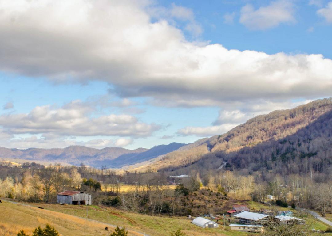
Giles County, Virginia is a mountain community known for its scenic beauty, outdoor recreation, and strong Appalachian roots. The county’s heritage includes farming, forestry, and a proud tradition of self-reliance and craftsmanship. Historic towns and local festivals reflect a deep sense of identity and community pride.
Rivers, forests, and trails offer residents and visitors opportunities for hiking, kayaking, and exploring natural landscapes. The New River and its surrounding parks are central to both relaxation and adventure. Life in Giles County is shaped by its connection to nature, tradition, and a slower, more grounded pace.
Where is Giles County?
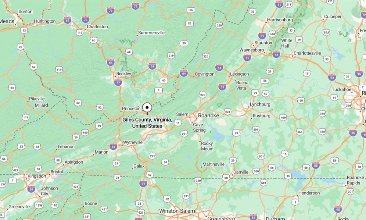
Giles County, Virginia is located in the southwestern part of the state, within the Appalachian Mountains and along the New River. It is approximately 24 miles northwest of Blacksburg, home to Virginia Tech. The county seat, Pearisburg, serves as the central hub in this largely rural and mountainous area.
From Roanoke, Giles County is about 70 miles west, accessible via U.S. Route 460. It is also roughly 250 miles west of Richmond, placing it deep within Virginia’s highland region. The county’s location offers scenic beauty, outdoor recreation, and a connection to the New River Valley.
#23. Lee County (tie)
– Life expectancy: 72.8 years
— 5.3 years lower than the state average
About
Lee County, Virginia is a rural area rich in Appalachian heritage, with a history rooted in farming, coal mining, and frontier life. The community is shaped by deep family ties, traditional values, and a strong sense of place. Historic buildings and local customs preserve the county’s cultural identity.
The landscape features rolling hills, forested ridges, and clear rivers that support outdoor living and recreation. Residents enjoy hunting, fishing, and participating in seasonal gatherings that highlight community spirit. Life in Lee County reflects resilience, simplicity, and a close bond with the land and history.
Where is Lee County?
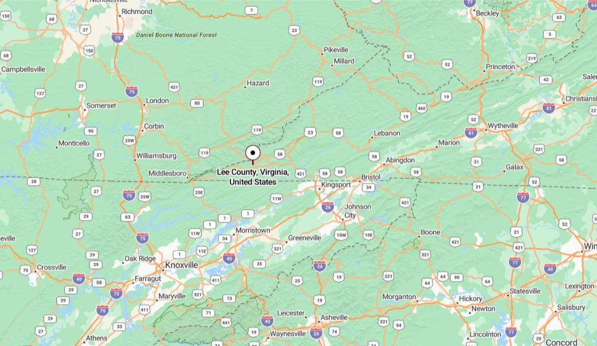
Lee County, Virginia is located at the extreme southwestern tip of the state, bordering both Kentucky and Tennessee. It is approximately 45 miles west of Kingsport, Tennessee, connected by U.S. Route 58 and Route 23. The county seat, Jonesville, sits in a rural mountain setting surrounded by natural landscapes.
From Roanoke, Lee County is about 190 miles southwest, making it one of the most remote counties in Virginia. It is also roughly 430 miles west of Richmond, placing it far from the state’s capital and coastal regions. Its location provides a gateway to the Central Appalachian region and a strong connection to neighboring states.
#23. Halifax County (tie)
– Life expectancy: 72.8 years
— 5.3 years lower than the state average
About
Halifax County, Virginia is a historically agricultural region known for tobacco farming, manufacturing, and deep-rooted community traditions. Historic sites, rural landscapes, and local events highlight the county’s enduring connection to its past. Generations of families have contributed to a strong culture of hard work and resilience.
The county offers rolling fields, forests, and river access that support outdoor recreation and a peaceful pace of life. Residents enjoy fishing, festivals, and local markets that bring people together. Halifax County blends heritage, natural beauty, and a strong sense of community.
Where is Halifax County?
Halifax County, Virginia is located in the south-central part of the state, along the North Carolina border. It is approximately 64 miles south of Lynchburg, connected by U.S. Route 501. The county seat, Halifax, is near South Boston, a larger town that serves as the county’s economic center.
From Richmond, Halifax County is about 120 miles southwest, offering a direct route through central Virginia. It is also roughly 200 miles south of Washington, D.C., making it part of the rural Southern Virginia region. The county’s location supports agriculture, manufacturing, and regional commerce.
#22. Colonial Heights
– Life expectancy: 72.5 years
— 5.6 years lower than the state average
About
Colonial Heights, Virginia is a small independent city with a strong blend of suburban life, historical significance, and community pride. Its roots trace back to early American history, with preserved landmarks and neighborhoods that reflect its past. The city maintains a balance between tradition and modern development.
Parks, schools, and family-oriented amenities contribute to a high quality of life and a close-knit community feel. Local events, recreational programs, and public spaces encourage year-round engagement. Colonial Heights offers a welcoming atmosphere shaped by stability, heritage, and civic spirit.
Where is Colonial Heights?
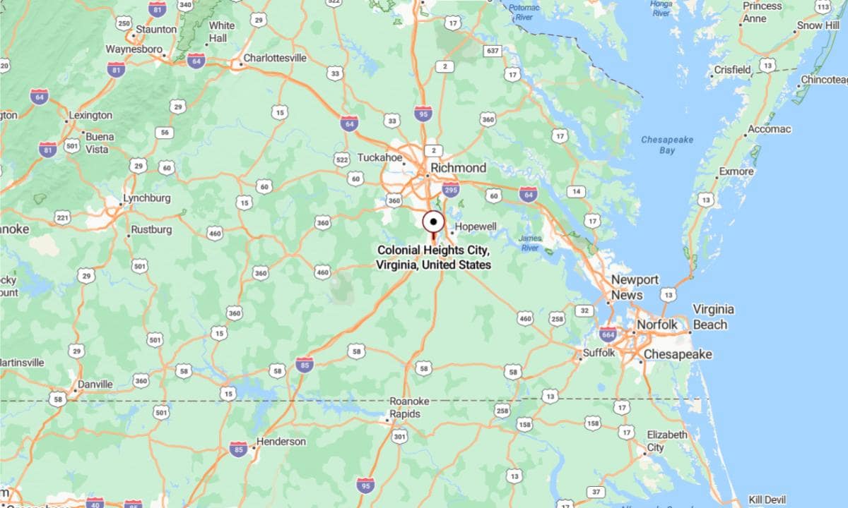
Colonial Heights, Virginia is located in the south-central region of the state, just south of the James River. It is approximately 160 miles south of Washington, D.C., connected by Interstate 95. This independent city borders Petersburg and is part of the Richmond–Petersburg metro area.
From Richmond, Colonial Heights is about 20 miles south, making it readily accessible via I‑95. It is also roughly 140 miles northeast of Raleigh, North Carolina, placing it within reach of the broader Mid-Atlantic corridor. Its location contributes to its role as a suburban and commercial node between major urban centers.
#21. Sussex County
– Life expectancy: 72.4 years
— 5.7 years lower than the state average
About
Sussex County, Virginia is a rural community known for its deep agricultural roots, historical landmarks, and quiet landscapes. The county has long been shaped by farming traditions, timber production, and small-town values. Local heritage is preserved through historic sites and community institutions.
Wide open fields, pine forests, and country roads define the natural environment, supporting a peaceful and steady lifestyle. Residents take pride in their land, family connections, and seasonal gatherings that reflect close community ties. Sussex County offers a way of life grounded in tradition, simplicity, and a strong sense of place.
Where is Sussex County?
Sussex County, Virginia is located in the southeastern region of the state, within Virginia’s Tidewater area. It is approximately 45 miles south of Richmond, accessible via Interstate 95 and U.S. Route 460. The county seat, Sussex, lies in a largely rural area known for agriculture and pine forests.
From Petersburg, Sussex County is about 25 miles southeast, making it part of the extended Richmond-Petersburg region. It is also roughly 160 miles south of Washington, D.C., providing a quiet, countryside setting within reach of major transportation routes. Its location supports farming, forestry, and local commerce in southeastern Virginia.
You may also like: Metros in Virginia that are best for nurses
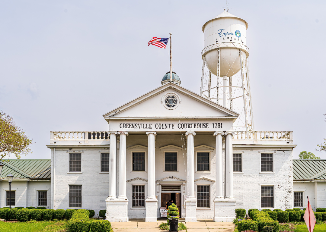
#20. Greensville County
– Life expectancy: 72.3 years
— 5.8 years lower than the state average
About
Greensville County, Virginia is a rural area with strong historical roots, shaped by agriculture, railroads, and local industry. Its communities reflect a legacy of resilience, with family-owned farms and long-standing institutions playing central roles. The county maintains a quiet, grounded character rooted in tradition and local pride.
The landscape includes farmland, wooded areas, and peaceful backroads that support both work and recreation. Residents value hunting, fishing, and community events that foster connection and shared heritage. Greensville County offers a lifestyle defined by simplicity, history, and a strong sense of belonging.
Where is Greensville County?
Greensville County, Virginia is located in the south-central part of the state, along the North Carolina border. It is approximately 65 miles south of Richmond, with major access via Interstate 95. The county seat, Emporia, serves as a key transportation and service hub for the region.
From Petersburg, Greensville County is about 40 miles south, making it part of the I‑95 corridor through southeastern Virginia. It is also roughly 170 miles south of Washington, D.C., providing a rural but accessible location for travel and commerce. The county’s position supports regional connectivity between Virginia and North Carolina.
#18. Dickenson County (tie)
– Life expectancy: 72.2 years
— 5.9 years lower than the state average
About
Dickenson County, Virginia is a mountainous region known for its coal mining legacy, deep Appalachian roots, and tight-knit communities. Generations of families have lived and worked here, preserving a culture built on resilience, music, and tradition. Local festivals, crafts, and storytelling reflect the pride in its heritage.
The rugged landscape features steep ridges, flowing rivers, and dense forests that offer natural beauty and outdoor adventure. Residents enjoy hiking, fishing, and gathering for seasonal events that celebrate both nature and community. Life in Dickenson County is shaped by strong family ties, cultural pride, and a close connection to the land.
Where is Dickenson County?
Dickenson County, Virginia is located in the far southwestern corner of the state, deep within the Appalachian Mountains. It is approximately 32 miles northwest of Wise, connected by mountain roads through rugged terrain. The county seat, Clintwood, lies in a remote and scenic region known for its coal mining history.
From Roanoke, Dickenson County is about 185 miles southwest, placing it among Virginia’s most isolated counties. It is also roughly 395 miles west of Richmond, making it distant from the state’s central and eastern urban centers. Its location highlights the county’s strong Appalachian cultural and geographical identity.
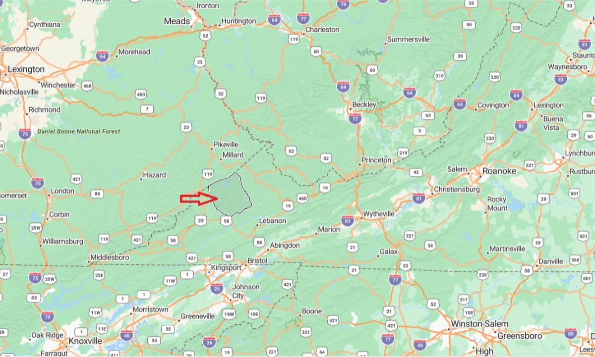
#18. Smyth County (tie)
– Life expectancy: 72.2 years
— 5.9 years lower than the state average
About
Smyth County, Virginia is a region rich in history, natural beauty, and Appalachian traditions. Its towns and rural areas reflect a legacy of farming, manufacturing, and community pride. Historic landmarks, local events, and cultural heritage contribute to its small-town character.
The landscape features mountains, rivers, and scenic trails that attract outdoor enthusiasts year-round. Residents enjoy hiking, fishing, and participating in festivals that showcase local talent and traditions. Smyth County offers a peaceful lifestyle grounded in nature, history, and a strong sense of belonging.
Where is Smyth County?
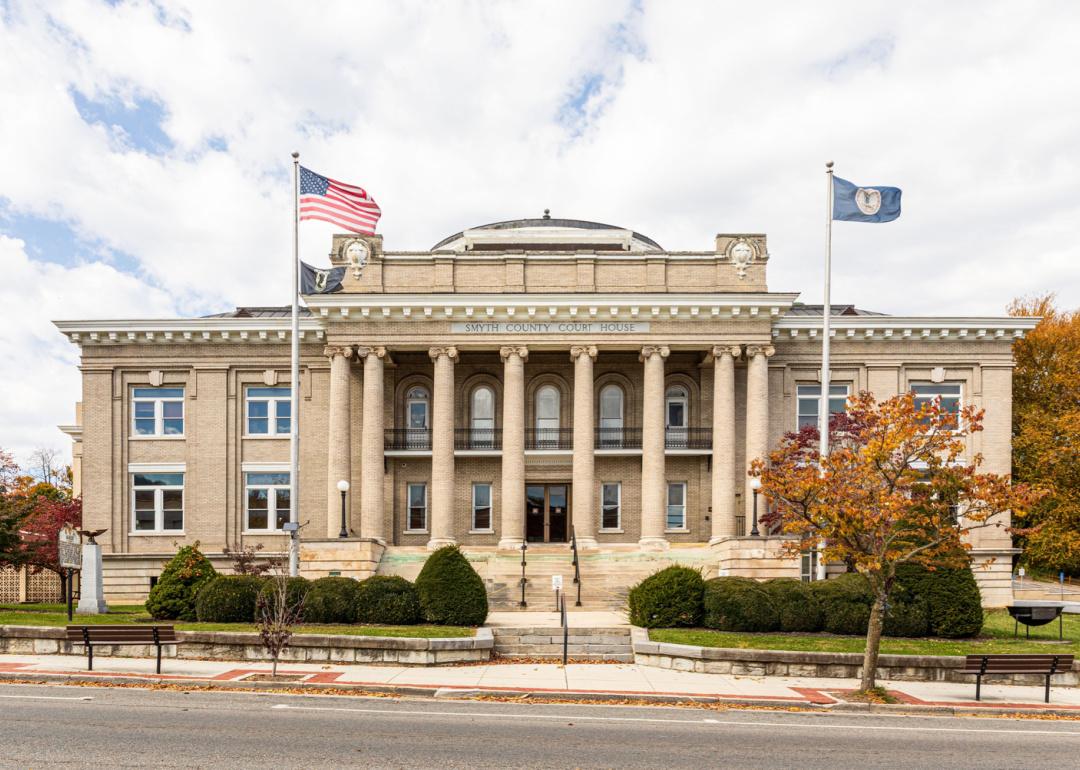
Smyth County, Virginia is located in the southwestern region of the state, within the Appalachian Mountains. It is approximately 27 miles northeast of Abingdon, accessible via Interstate 81. The county seat, Marion, serves as a local center for government, commerce, and healthcare.
From Roanoke, Smyth County is about 110 miles southwest, making it part of Virginia’s mountainous corridor. It is also roughly 275 miles west of Richmond, placing it well within the Appalachian Highlands. Its location supports a mix of natural beauty, rural communities, and access to major transportation routes.
#16. Henry County (tie)
– Life expectancy: 72.1 years
— 6.0 years lower than the state average
About
Henry County, Virginia is a community shaped by its industrial heritage, especially in textiles and furniture manufacturing. Its history is reflected in local museums, historic sites, and the pride of longtime residents. The area maintains a balance of economic resilience and small-town charm.
Rolling hills, rivers, and parks offer scenic spaces for outdoor activities like hiking, fishing, and boating. Local events, schools, and recreational programs foster strong community engagement. Henry County combines tradition, hardworking values, and a welcoming environment for families and visitors alike.
Where is Henry County?
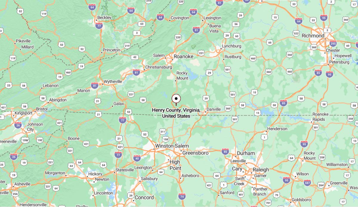
Henry County, Virginia is located in the southern part of the state, along the North Carolina border. It is approximately 51 miles south of Roanoke, connected by U.S. Route 220. The county seat, Martinsville, serves as the economic and cultural center of the area.
From Richmond, Henry County is about 150 miles southwest, offering access to both central Virginia and the Piedmont region of North Carolina. It is also roughly 270 miles southwest of Washington, D.C., placing it in the rural southern portion of the state. Its location supports manufacturing, regional trade, and cross-border connectivity.
#16. Portsmouth (tie)
– Life expectancy: 72.1 years
— 6.0 years lower than the state average
About
Portsmouth, Virginia is a historic city known for its maritime heritage, naval presence, and vibrant arts scene. Its downtown features preserved architecture, cultural institutions, and a deep connection to centuries of shipbuilding and trade. The community values both its historical legacy and ongoing revitalization efforts.
The city offers waterfront parks, museums, and events that highlight its cultural richness and community pride. Residents enjoy festivals, public art, and access to scenic views and recreational activities. Portsmouth blends tradition, creativity, and civic energy into a unique urban experience.
Where is Portsmouth?
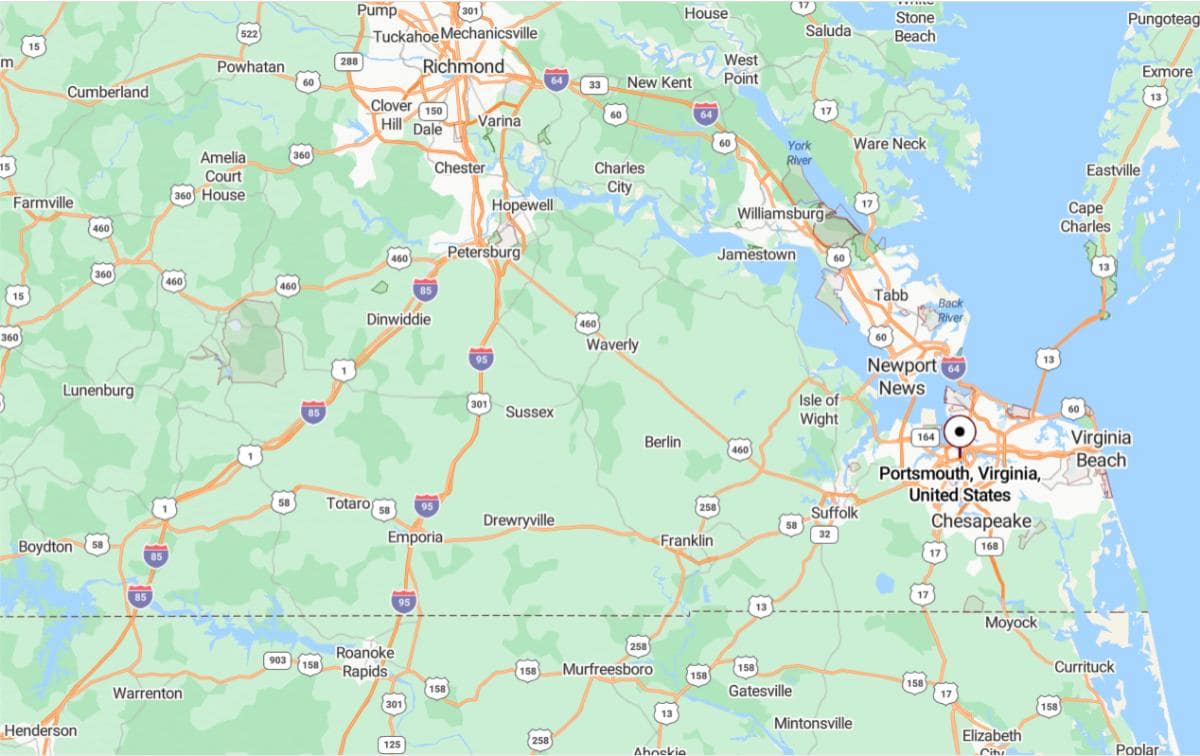
Portsmouth, Virginia is located in the southeastern part of the state, along the Elizabeth River in the Hampton Roads region. It is approximately 21 miles west of Virginia Beach, connected by multiple tunnels and bridges. The city is directly across the river from Norfolk and plays a key role in naval operations and regional shipping.
From Richmond, Portsmouth is about 95 miles southeast, accessible via Interstate 64. It is also roughly 200 miles south of Washington, D.C., placing it in Virginia’s coastal urban corridor. Its location supports a mix of maritime industry, military presence, and urban development.
You may also like: The best beach towns in Virginia
#15. Buchanan County
– Life expectancy: 72.0 years
— 6.1 years lower than the state average
About
Buchanan County, Virginia is a rugged Appalachian region with a strong legacy in coal mining, forestry, and mountain traditions. Its communities are deeply rooted in resilience, family values, and pride in local history. Generations have preserved a way of life centered on hard work and self-reliance.
The landscape features steep hills, winding rivers, and quiet hollows that offer natural beauty and outdoor recreation. Residents enjoy hunting, fishing, and gatherings that celebrate heritage and unity. Buchanan County reflects a lifestyle grounded in nature, tradition, and enduring community spirit.
Where is Buchanan County?
Buchanan County, Virginia is located in the far western part of the state, within the Appalachian Plateau near the Kentucky and West Virginia borders. It is approximately 36 miles northwest of Grundy, the county seat, which serves as the main population center. The county is known for its rugged terrain and strong coal mining heritage.
From Roanoke, Buchanan County is about 190 miles west, situated deep in Virginia’s coalfields region. It is also roughly 400 miles west of Richmond, making it one of the most remote counties in the state. Its location reflects a distinctly Appalachian landscape and culture with strong ties to neighboring states.
#14. Charlotte County
– Life expectancy: 71.8 years
— 6.3 years lower than the state average
About
Charlotte County, Virginia is a rural community steeped in agricultural history, colonial heritage, and quiet charm. Historic courthouses, churches, and family farms highlight the area’s long-standing traditions and deep community ties. The county values simplicity, independence, and a strong connection to the land.
Rolling fields, woodlands, and peaceful country roads define the natural setting and support a steady pace of life. Residents enjoy farming, hunting, and participating in local events that bring neighbors together. Charlotte County offers a lifestyle rooted in heritage, nature, and close-knit community bonds.
Where is Charlotte County?
Charlotte County, Virginia is located in the south-central region of the state, within the Piedmont area. It is approximately 75 miles southwest of Richmond, accessible via U.S. Route 360. The county seat, Charlotte Court House, is a small historic town with deep colonial roots.
From Lynchburg, Charlotte County is about 45 miles southeast, providing access to both rural farmland and central Virginia communities. It is also roughly 150 miles south of Washington, D.C., placing it within reach of major metropolitan areas while maintaining a quiet, rural setting. Its location supports agriculture, history, and small-town living.
#13. Buena Vista
– Life expectancy: 71.6 years
— 6.5 years lower than the state average
About
Buena Vista, Virginia is a small city known for its historic charm, close-knit community, and scenic surroundings. Originally shaped by industry and railroads, it has maintained a spirit of resilience and pride in local traditions. Historic buildings and community events reflect a deep sense of identity.
Nestled among mountains and rivers, the city offers access to hiking, fishing, and outdoor recreation year-round. Residents enjoy a peaceful pace of life, supported by local schools, businesses, and civic pride. Buena Vista blends natural beauty, heritage, and a strong sense of belonging.
Where is Buena Vista?
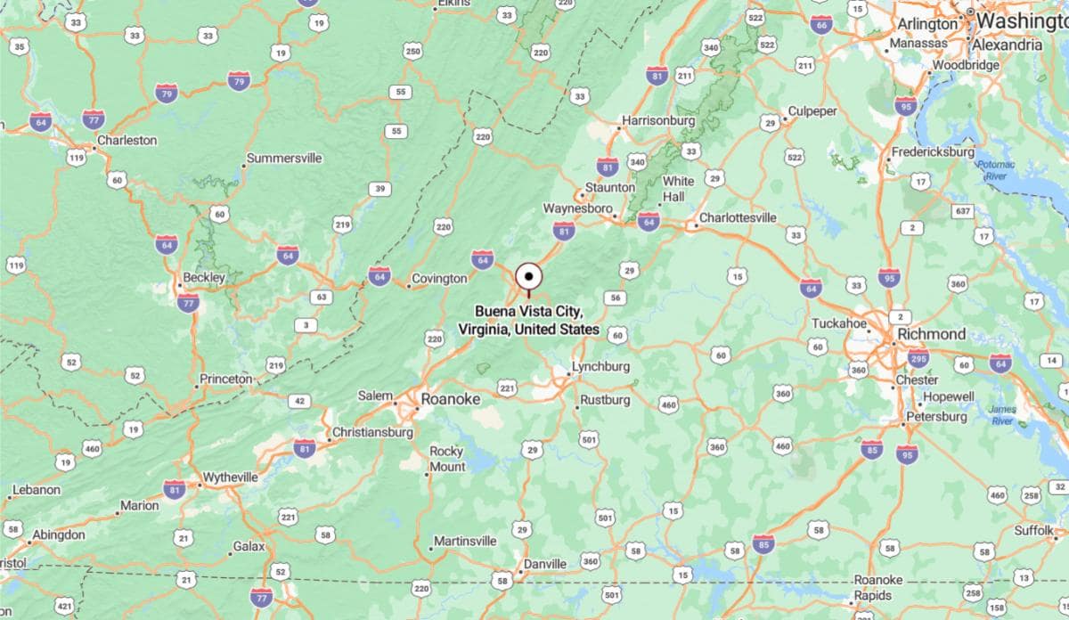
Buena Vista, Virginia is located in the west-central part of the state, nestled in the Blue Ridge Mountains along the Maury River. It is approximately 6 miles southeast of Lexington, connected by U.S. Route 60. The city is known for its scenic surroundings and proximity to national forest land.
From Roanoke, Buena Vista is about 50 miles north, offering a direct route through the Shenandoah Valley region. It is also roughly 145 miles west of Richmond, making it a peaceful mountain community within driving distance of the state capital. Its location supports outdoor recreation and a close connection to nearby educational and cultural institutions.
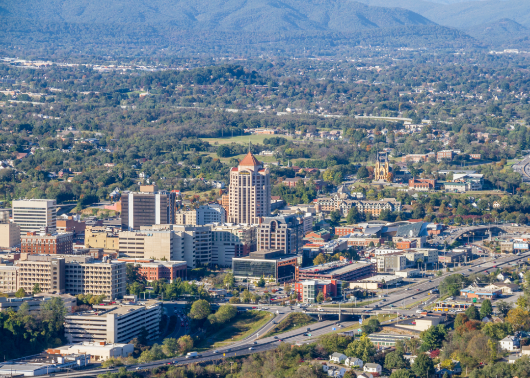
#12. Roanoke
– Life expectancy: 71.4 years
— 6.7 years lower than the state average
About
Roanoke, Virginia is a vibrant city with a strong blend of history, industry, and cultural energy. Once a major railroad hub, it has grown into a center for healthcare, education, and the arts. Historic neighborhoods and revitalized districts reflect both tradition and modern progress.
Surrounded by scenic mountains, Roanoke offers abundant outdoor opportunities including hiking, biking, and kayaking. The city hosts festivals, markets, and cultural events that celebrate its diverse community. Roanoke balances urban amenities with natural beauty and a strong sense of local pride.
Where is Roanoke?
Roanoke, Virginia is located in the southwestern part of the state, nestled in the Roanoke Valley between the Blue Ridge and Allegheny Mountains. It is approximately 52 miles northeast of Blacksburg, home to Virginia Tech. The city serves as a major commercial and transportation hub in western Virginia.
From Richmond, Roanoke is about 165 miles west, accessible via Interstate 64 and Interstate 81. It is also roughly 240 miles southwest of Washington, D.C., placing it within the Appalachian region. Its location provides a balance of urban services and access to outdoor recreation in the surrounding mountains.
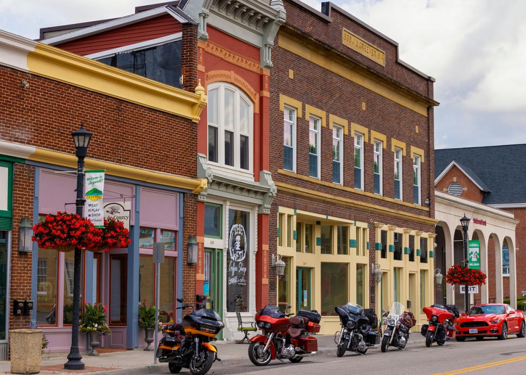
#11. Tazewell County
– Life expectancy: 71.2 years
— 6.9 years lower than the state average
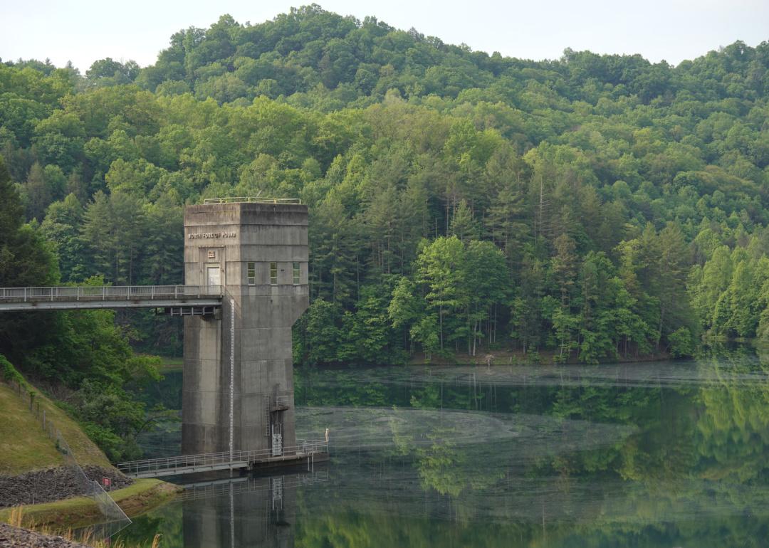
About
Tazewell County, Virginia is a mountainous region rooted in coal mining, agriculture, and strong Appalachian traditions. Historic towns, local festivals, and community pride reflect a culture built on resilience and deep family ties. The county values its heritage and maintains a strong connection to its past.
The natural landscape features rolling hills, rivers, and scenic byways that invite outdoor exploration and relaxation. Residents enjoy hunting, fishing, and seasonal gatherings that highlight their connection to the land. Tazewell County offers a quiet, grounded lifestyle shaped by nature, history, and community spirit.
Where is Tazewell County?
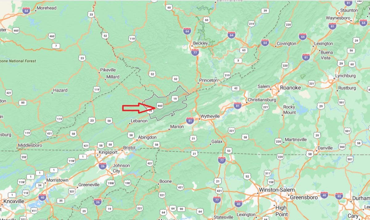
Tazewell County, Virginia is located in the southwestern part of the state, within the Appalachian Mountains and the Cumberland Plateau. It is approximately 27 miles northwest of Bluefield, a nearby city that spans the Virginia–West Virginia border. The county seat, also named Tazewell, lies in a region known for its coal mining history and mountainous landscape.
From Roanoke, Tazewell County is about 130 miles southwest, connected by U.S. Route 460 through rugged terrain. It is also roughly 310 miles west of Richmond, placing it deep in Virginia’s Appalachian coal region. Its location reflects a strong cultural and economic tie to neighboring West Virginia and eastern Kentucky.
You may also like: Counties with the worst droughts in Virginia
#10. Wise County
– Life expectancy: 71.1 years
— 7.0 years lower than the state average
About
Wise County, Virginia is a region deeply connected to its coal mining legacy, Appalachian culture, and educational institutions. The area is known for its strong community ties, local traditions, and pride in its historical roots. Music, crafts, and storytelling play a central role in preserving its cultural identity.
Surrounded by mountains and natural beauty, Wise County offers ample opportunities for hiking, fishing, and outdoor recreation. Residents participate in festivals, fairs, and community events that celebrate both heritage and progress. Life in Wise County reflects a balance of resilience, tradition, and connection to the land.
Where is Wise County?
Wise County, Virginia is located in the far southwestern corner of the state, within the Appalachian Mountains. It is approximately 48 miles northwest of Abingdon, connected by U.S. Route 58 and other regional roads. The county seat, Wise, lies in a mountainous area known for coal mining and higher education.
From Roanoke, Wise County is about 165 miles southwest, offering access through a combination of interstates and mountain routes. It is also roughly 370 miles west of Richmond, placing it among the most remote counties from Virginia’s capital. The county’s location supports a strong Appalachian identity with ties to regional commerce and education.
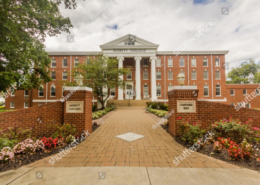
#9. Danville
– Life expectancy: 69.4 years
— 8.7 years lower than the state average
About
Danville, Virginia is a city with a strong industrial past, known for its textile and tobacco legacy, now undergoing revitalization and growth. Historic architecture, museums, and cultural institutions reflect its rich heritage and evolving identity. The community values resilience, innovation, and a renewed focus on progress.
The city offers scenic riverfronts, parks, and trails that support an active lifestyle and public engagement. Residents enjoy local festivals, markets, and a growing arts and entertainment scene. Danville blends tradition with transformation, creating a vibrant and forward-looking atmosphere.
Where is Danville?
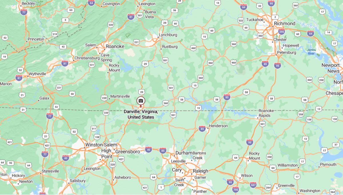
Danville, Virginia is located in the south-central part of the state, along the North Carolina border. It is approximately 45 miles south of Lynchburg, connected by U.S. Route 29. The city sits along the Dan River and serves as a regional hub for southern Virginia.
From Richmond, Danville is about 140 miles southwest, making it accessible via major highways through central Virginia. It is also roughly 145 miles northwest of Raleigh, North Carolina, providing cross-state connectivity. Its location supports manufacturing, education, and regional commerce in the Virginia–North Carolina corridor.
#8. Covington
– Life expectancy: 69.3 years
— 8.8 years lower than the state average
About
Covington, Virginia is a small city with a rich industrial heritage, historically centered around its paper mill and manufacturing roots. Its downtown area offers a charming mix of historic architecture and community-driven events that reflect local pride. The city maintains a spirit of resilience and close-knit connection among residents.
Nestled along the Jackson River and surrounded by the Allegheny Mountains, Covington features plenty of outdoor recreation opportunities. Hiking, fishing, and river enjoyment are woven into daily life, supported by nearby trails and parks. With a balance of natural beauty and hometown warmth, Covington offers a tranquil yet vibrant community atmosphere.
Where is Covington?
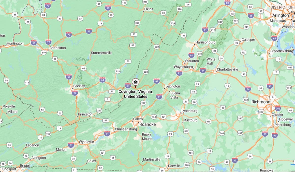
Covington, Virginia is located in the west-central part of the state, within the Alleghany Highlands and surrounded by national forest land. It is approximately 26 miles northwest of Lexington, accessible via Interstate 64. The city serves as the independent seat of Alleghany County and lies along the Jackson River.
From Roanoke, Covington is about 50 miles northwest, offering a direct route through mountainous terrain. It is also roughly 165 miles west of Richmond, placing it in a remote and scenic part of Virginia. Covington’s location supports outdoor recreation and regional industry within the Appalachian Mountains.
#7. Norton
– Life expectancy: 69.0 years
— 9.1 years lower than the state average
About
Norton, Virginia is a small independent city with deep Appalachian roots and a strong sense of community pride. Historically connected to coal mining and railroads, it has maintained its cultural heritage through local traditions and storytelling. The city reflects resilience, simplicity, and a close bond among its residents.
Surrounded by forested mountains and scenic vistas, Norton offers outdoor recreation like hiking, biking, and fishing. Community events, music festivals, and local markets bring people together throughout the year. Norton blends natural beauty with a quiet, grounded lifestyle shaped by tradition and shared values.
Where is Norton?
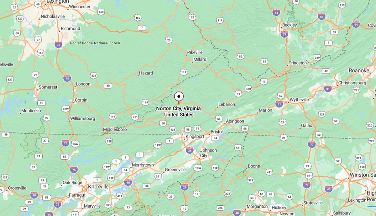
Norton, Virginia is an independent city located in the far southwestern region of the state, within the Appalachian Mountains. It is approximately 23 miles northwest of Wise, connected by U.S. Route 23. Surrounded by forested ridges, Norton is the smallest independent city in Virginia and serves as a local economic and service center.
From Roanoke, Norton is about 180 miles southwest, accessible through mountainous highways and interstates. It is also roughly 390 miles west of Richmond, placing it among the most remote urban areas in the state. Norton’s location reflects a strong Appalachian identity with close ties to coal mining and natural resources.
#6. Hopewell
– Life expectancy: 68.5 years
— 9.6 years lower than the state average
About
Hopewell, Virginia is a historic riverfront city shaped by its industrial roots and strong community spirit. Its economy has long been supported by manufacturing and chemical production, with a workforce known for resilience and pride. Historic districts, schools, and civic institutions reflect the city’s enduring legacy.
The city features parks, trails, and waterfront views that offer spaces for recreation and reflection. Residents enjoy local festivals, cultural events, and a growing interest in revitalization and development. Hopewell combines tradition, industry, and a strong sense of local identity in its everyday life.
Where is Hopewell?
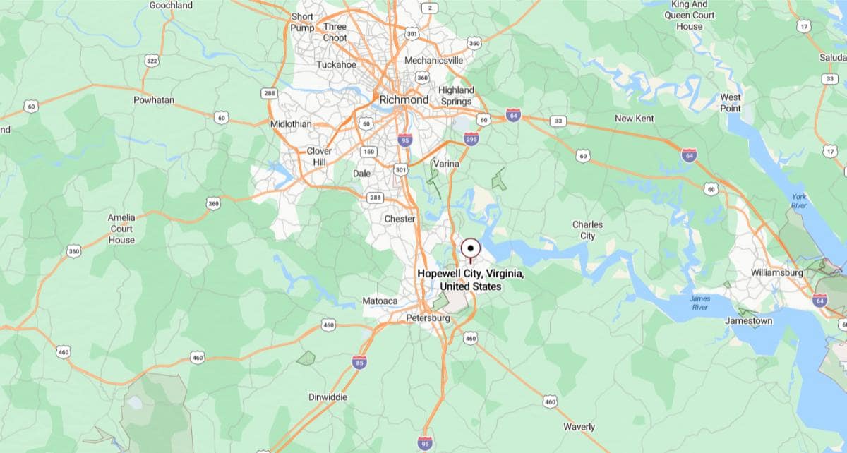
Hopewell, Virginia is located in the southeastern part of the state at the confluence of the Appomattox and James Rivers. It is approximately 24 miles southeast of Richmond, accessible via Interstate 295 and Route 10. The city is part of the Tri-Cities area, along with Petersburg and Colonial Heights.
From Petersburg, Hopewell is about 10 miles northeast, making it a short drive within the greater Richmond region. It is also roughly 130 miles south of Washington, D.C., placing it within Virginia’s industrial and transportation corridor. Its location supports manufacturing, port access, and regional connectivity.
You may also like: How much manufacturers in Virginia spend on equipment
#5. Franklin
– Life expectancy: 67.9 years
— 10.2 years lower than the state average
About
Franklin, Virginia is a small city known for its strong ties to the paper industry, railroads, and agricultural traditions. Its history is reflected in the preserved downtown area, where local businesses and historic buildings line the streets. Community pride and a deep connection to the land shape everyday life.
The city offers a peaceful setting with access to rivers, parks, and green spaces that support outdoor recreation. Residents enjoy festivals, farmers markets, and events that celebrate local heritage and culture. Franklin blends industrial heritage with small-town warmth and resilience.
Where is Franklin?
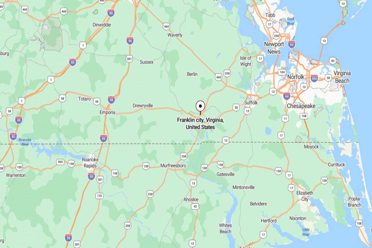
Franklin, Virginia is located in the southeastern region of the state, near the Blackwater River and close to the North Carolina border. It is approximately 44 miles west of Norfolk, accessible via U.S. Route 58. The city is surrounded by rural farmland and has historical roots in timber and paper manufacturing.
From Richmond, Franklin is about 75 miles south, offering a direct route through southeastern Virginia. It is also roughly 175 miles south of Washington, D.C., placing it within reach of both state and national urban centers. Franklin’s location supports agriculture, industry, and regional commerce in southern Virginia.
#4. Emporia
– Life expectancy: 67.3 years
— 10.8 years lower than the state average
About
Emporia, Virginia is a small city with deep roots in transportation, trade, and agriculture. Its history is tied to railroads and commerce, shaping a strong sense of purpose and local identity. The community is close-knit, with long-standing traditions and pride in its heritage.
Surrounded by open landscapes and rural beauty, Emporia offers a peaceful environment with access to outdoor activities. Residents value their town’s quiet pace, community events, and small business support. Life in Emporia is marked by simplicity, connection, and a steady commitment to preserving local character.
Where is Emporia?
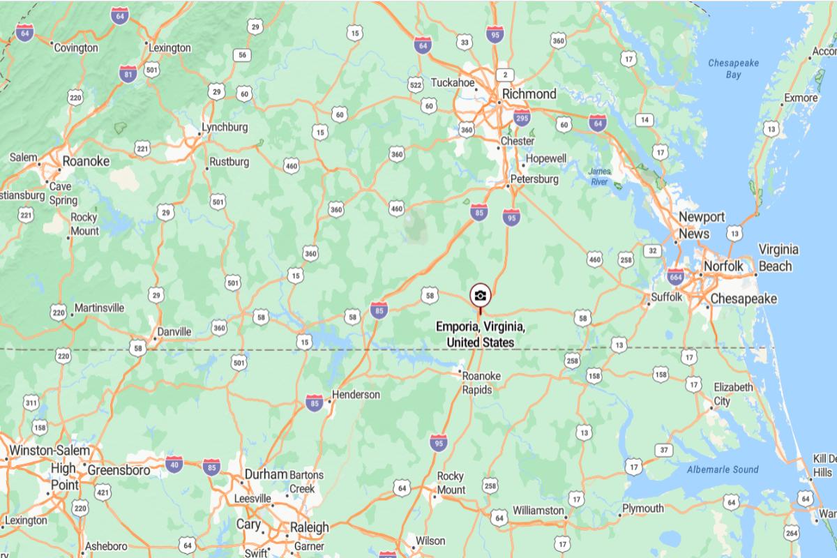
Emporia, Virginia is located in the south-central part of the state, near the North Carolina border. It is approximately 66 miles south of Richmond, easily reached via Interstate 95. As an independent city, Emporia serves as a key transportation and service center in the region.
From Petersburg, Emporia is about 42 miles south, positioned along the I‑95 corridor. It is also roughly 170 miles south of Washington, D.C., making it an important stop between the capital and the southeastern United States. Its location supports highway travel, regional trade, and cross-border access with North Carolina.
#3. Martinsville
– Life expectancy: 66.7 years
— 11.4 years lower than the state average
About
Martinsville, Virginia is a city with a strong industrial legacy, once known for its textile and furniture manufacturing. Though it has faced economic shifts, the community has embraced revitalization through arts, education, and entrepreneurship. Historic buildings and local pride reflect a culture of resilience and reinvention.
The city is surrounded by scenic hills and offers access to trails, rivers, and outdoor recreation. Martinsville Speedway and community festivals highlight the area’s spirit of celebration and connection. Life in Martinsville blends tradition with innovation, creating a dynamic and community-focused environment.
Where is Martinsville?
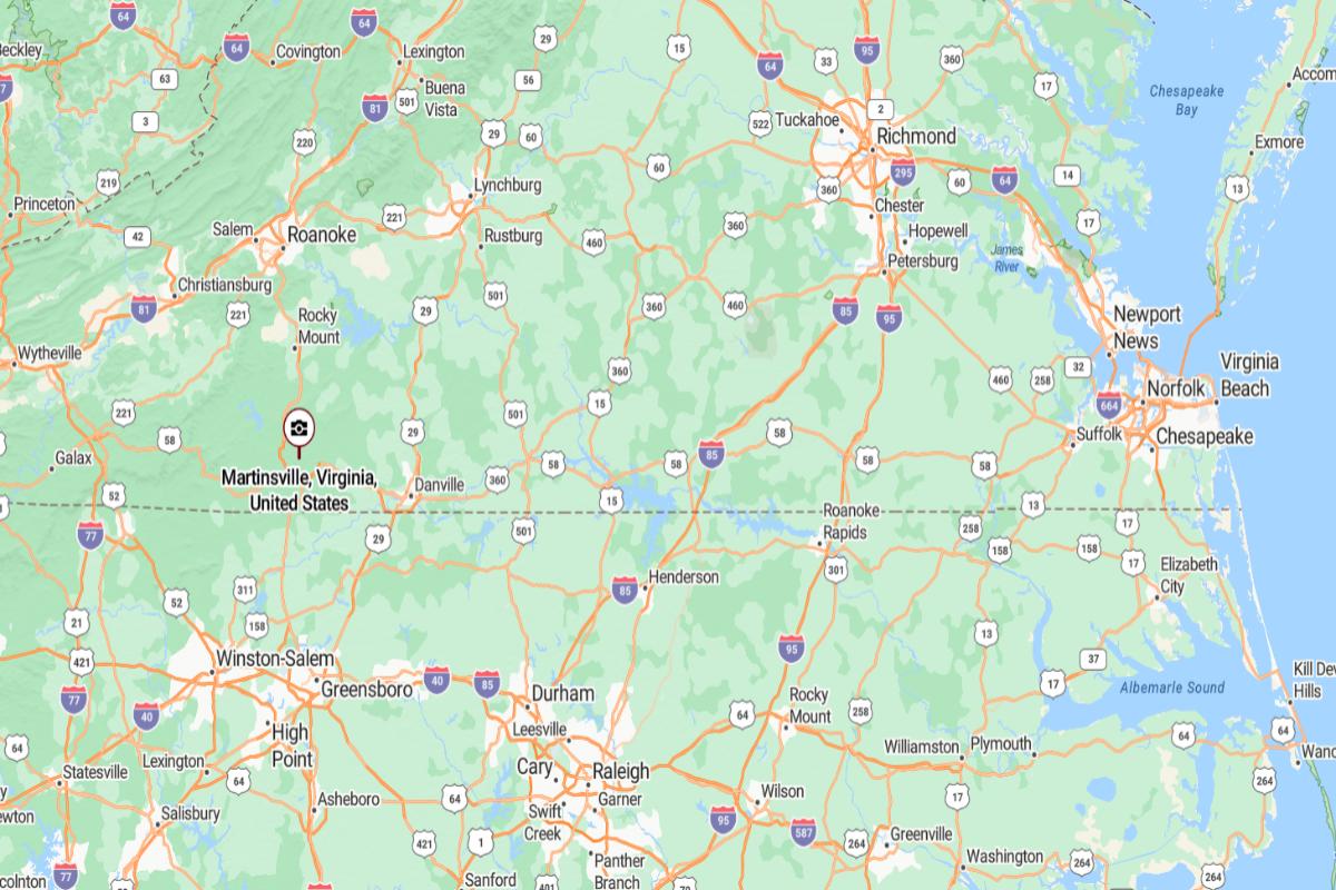
Martinsville, Virginia is located in the southern part of the state, near the North Carolina border in the foothills of the Blue Ridge Mountains. It is approximately 50 miles south of Roanoke, connected via U.S. Route 220. The city has a strong industrial history and serves as the economic center of Henry County.
From Richmond, Martinsville is about 150 miles southwest, offering access to central and southern Virginia. It is also roughly 270 miles southwest of Washington, D.C., placing it in a rural region with ties to both Virginia and North Carolina. Its location supports manufacturing, motorsports, and regional commerce.
#2. Galax
– Life expectancy: 66.2 years
— 11.9 years lower than the state average
About
Galax, Virginia is a small city celebrated for its vibrant musical heritage and Appalachian culture. It hosts the renowned Old Fiddlers’ Convention each summer, drawing bluegrass and old-time music enthusiasts from across the region. The downtown area reflects local pride with festivals, shops, and community events centered around traditional arts.
Surrounded by scenic landscapes, Galax offers access to trails, rivers, and parks that support hiking, fishing, and outdoor recreation. The close-knit community maintains a strong commitment to preserving its cultural roots while embracing small-town life. Galax’s charm lies in its harmonious blend of natural beauty, musical legacy, and warm community spirit.
Where is Galax?
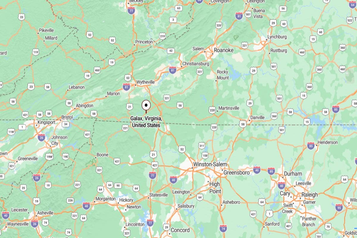
Galax, Virginia is located in the southwestern part of the state, near the Blue Ridge Parkway and the North Carolina border. It is approximately 36 miles southwest of Wytheville, connected by U.S. Route 58. Known for its musical heritage, Galax sits in a mountainous region rich in Appalachian culture.
From Roanoke, Galax is about 95 miles southwest, accessible through a network of mountain highways. It is also roughly 265 miles west of Richmond, placing it deep within Virginia’s Appalachian Highlands. Its location supports tourism, traditional music events, and outdoor recreation in the Blue Ridge region.
#1. Petersburg
– Life expectancy: 64.9 years
— 13.2 years lower than the state average
About
Petersburg, Virginia is a historic city deeply shaped by its role in the Civil War and its past as a transportation and industrial center. Its streets are lined with preserved architecture, battlegrounds, and cultural landmarks that speak to centuries of resilience and change. The community honors its legacy while embracing a spirit of renewal and growth.
Recent revitalization efforts have brought new energy to its downtown, with local businesses, art spaces, and historic renovations attracting visitors and residents alike. The city also features riverfront trails, parks, and festivals that foster civic pride and community connection. Petersburg blends deep historical roots with a forward-looking, creative atmosphere.
Where is Petersburg?
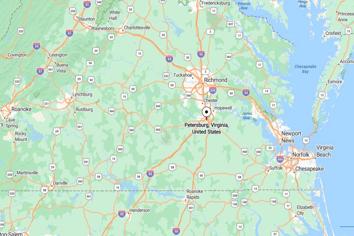
Petersburg, Virginia is located in the south-central region of the state, along the Appomattox River. It is approximately 24 miles south of Richmond, easily reached via Interstate 95. The city plays a key role in Virginia’s transportation network and holds significant Civil War history.
From Norfolk, Petersburg is about 80 miles northwest, making it part of the greater Hampton Roads to Richmond corridor. It is also roughly 125 miles south of Washington, D.C., placing it within a central position along the East Coast. Petersburg’s location supports commerce, logistics, and regional connectivity.
This story features data reporting by Karim Noorani, writing by Kiersten Hickman, and is part of a series utilizing data automation across 49 states.
You may also like: Counties where children have the best opportunity for economic mobility in Virginia
By Stacker