The highlands of Northwest South Carolina unfold in a mix of ridges, valleys, and lakes where geography has always been the stronger hand. Table Rock rises with its sheer granite face above the forests, while Lake Jocassee spreads below with coves and waterfalls that swallow roads leading nowhere. Together they set the tone for a landscape that shapes every community within it.
In order to come up with the very specific design ideas, we create most designs with the assistance of state-of-the-art AI interior design software.
Towns here tend to cluster where the land allows. A mill village on the Little River, a crossroads church near orchard rows, or houses set back from the coves of Keowee—they exist in relation to the ground itself. Distance is measured less in miles than in the turns it takes to get there.
What holds them is persistence rather than growth. A post office that still sorts mail for a handful of families, a ridge road that farmers have driven for generations, or a trail where trout streams outlasted the industry that once fed on them—each detail fixes these places firmly in the highlands.
This guide follows 25 secluded towns across that terrain, settlements defined as much by the mountains and waterways as by the people who remain. They stand steady, marked by the features around them, and offer a measure of South Carolina that endures in the folds of its highlands.
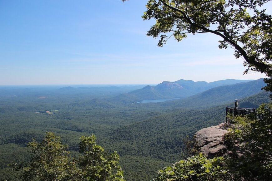
25. Eastatoe
Eastatoe, South Carolina feels like a hidden hollow, tucked in the shadow of the Blue Ridge Mountains where winding roads slip between forests and streams. Its sense of seclusion comes from the steep ridges that surround it, cutting it off from the pace of bigger towns.
The air carries a wild stillness, broken only by the rush of Eastatoe Creek and the calls of birds weaving through the trees. Hikers are drawn to the Eastatoe Creek Heritage Preserve, where rare wildflowers bloom and trails lead to secret waterfalls.
Fishing in the trout-filled waters or simply sitting along the creek’s edge are simple pleasures that define the place. Eastatoe lingers in your memory as a town where nature speaks louder than anything else, and silence feels like a gift.
Where is Eastatoe?
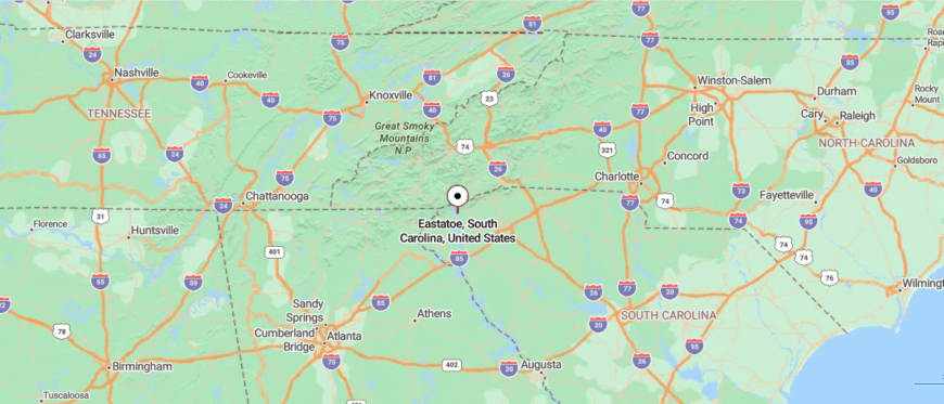
Eastatoe sits in Pickens County, in the northwestern corner of South Carolina, nestled within the Blue Ridge foothills. It’s about 35 miles west of Greenville, reached by U.S. Highway 178 before giving way to narrow, winding roads that trace forested slopes.
The trip feels increasingly secluded as the pavement twists past creeks and dense woods, leading deeper into the quiet hills. By the time you reach Eastatoe, the stillness of the mountains settles in, wrapping the town in a calm that feels worlds apart.
24. Rocky Bottom
Rocky Bottom, South Carolina lies in the Blue Ridge foothills near the North Carolina line, where winding mountain roads keep it tucked away from the rest of the world. The town is small and scattered, its homes and farms pressed close to forests and creeks that shape daily life.
Nature dominates here—the sound of rushing streams, the call of birds, and the quiet of deep woods define the atmosphere. Visitors often explore the Rocky Bottom Retreat and Conference Center, a gateway to trails, wildlife watching, and sweeping ridge views.
Most residents look to nearby towns for work, but the mountains themselves remain the true anchor of the community. Rocky Bottom leaves you with the feeling of being embraced by the hills, where stillness is both constant and comforting.
Where is Rocky Bottom?
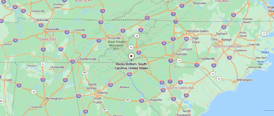
Rocky Bottom rests at the northern edge of Pickens County, South Carolina, just a few miles from the North Carolina line. It’s about 40 miles northwest of Greenville, reached by following scenic Highway 178 as it climbs steadily into the Blue Ridge Mountains.
The road narrows and winds through dense forest, with sharp turns that heighten the sense of leaving busier places behind. By the time you arrive, Rocky Bottom feels like a mountain hollow, tucked so deep in the ridges that the outside world slips away.
23. Oolenoy
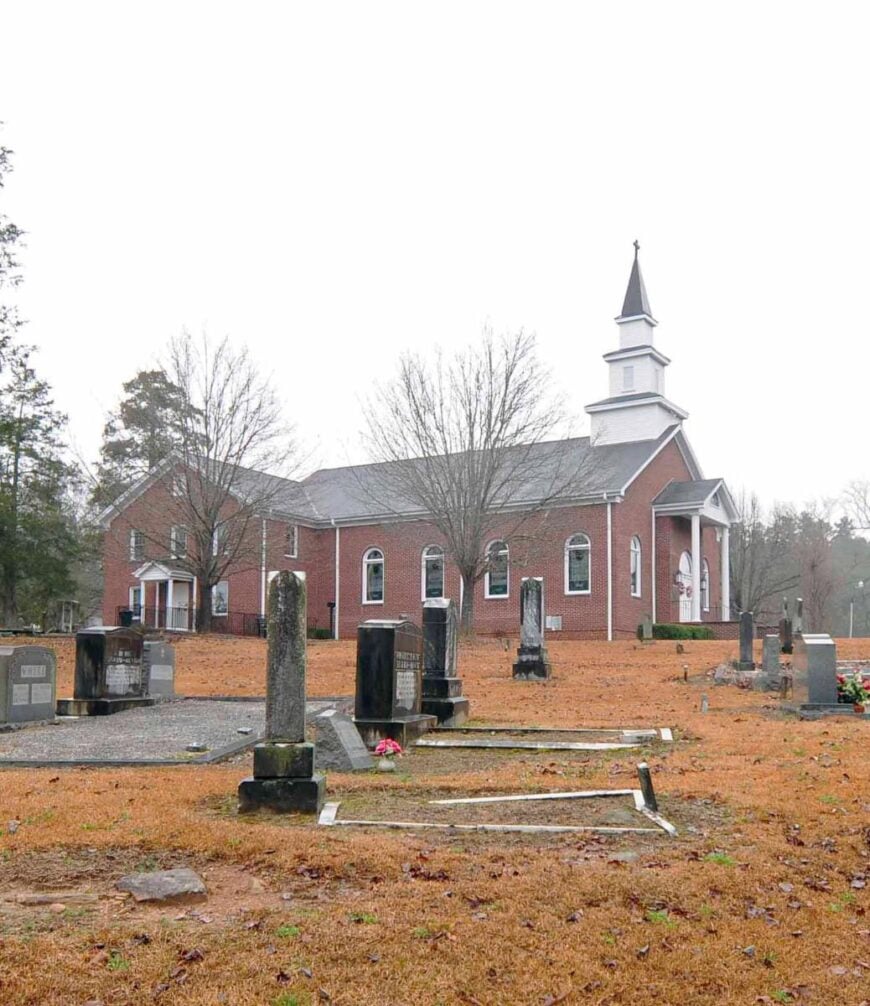
Oolenoy, South Carolina rests in the shadow of Table Rock, surrounded by forests and farmland that give it the feel of a valley set apart. Its seclusion comes from winding country roads that keep it hidden, a place you find only if you know where to look.
The community’s roots run deep, with historic churches and family farms still shaping the rhythm of life. Visitors are drawn to nearby Table Rock State Park for hiking, fishing, and mountain views that stretch endlessly.
Farming and small crafts continue to sustain many who live here, tying each season to the land. Oolenoy lingers in memory as a place where mountains and tradition meet, and where time seems to settle gently on the landscape.
Where is Oolenoy?
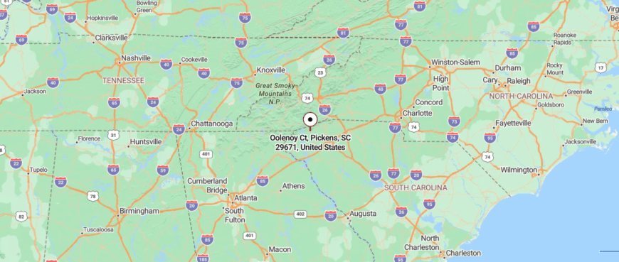
Oolenoy lies in northern Pickens County, South Carolina, nestled near the entrance to Table Rock State Park. It’s about 30 miles northwest of Greenville, reached by traveling U.S. 276 before veering onto winding backroads that hug the foothills.
The journey carries you past orchards, wooded slopes, and clear mountain streams, each turn pulling you deeper into quiet country. By the time you reach Oolenoy, the air feels thinner and still, as if the hills themselves hold the town in quiet embrace.
22. River Falls

River Falls, South Carolina sits tucked against the Blue Ridge Mountains, where narrow roads slip past forests and streams to a place that feels far removed from modern rush. Its isolation is shaped by rugged terrain, with the Middle Saluda River winding nearby and waterfalls hidden deep in the woods.
The town carries a rustic calm, the kind of place where evenings are filled with the sound of rushing water and the hush of crickets. Outdoor lovers find their way to Jones Gap State Park, with trails that lead to overlooks, trout fishing spots, and quiet stretches of riverbank.
Few businesses operate here, leaving the land and the seasons as the true markers of daily life. River Falls draws you in with the sense that nature has the final word, offering peace that feels untouchable.
Where is River Falls?

River Falls sits in northern Greenville County, South Carolina, tucked against the Blue Ridge foothills and close to Jones Gap State Park. It’s about 35 miles north of Greenville, reached by winding along U.S. 276 before turning onto narrow mountain roads that climb into forested ridges.
The trip feels increasingly remote as the pavement gives way to sharp bends, rushing creeks, and thick woods. When you arrive, River Falls feels hidden in the folds of the mountains, a place where the outside world seems to fade away.
21. Holly Springs

Holly Springs, South Carolina sits where rolling farmland meets the foothills of the Blue Ridge, giving it the feel of a town perched between open fields and rising mountains. Its tucked-away character comes from winding country lanes and the quiet pace of a community that has never grown too large.
The town’s roots are tied to farming and family homesteads, with old barns and wide pastures still shaping its landscape. Visitors often stop at the historic Holly Springs Center, a hub for local crafts, music, and community events that preserve Appalachian traditions.
Outdoor escapes are close at hand, from fishing in nearby lakes to hiking trails that climb into the hills. Holly Springs leaves you with the impression of a place where land, history, and community weave together into a calm and steady rhythm.
Where is Holly Springs?

Holly Springs lies in northern Spartanburg County, South Carolina, set among rolling foothills not far from the Blue Ridge Mountains. It’s about 25 miles north of Spartanburg, reached by taking I-26 before easing onto quieter two-lane roads that cut through farmland and wooded ridges.
The approach moves at an unhurried pace, with each turn carrying you farther from the hum of the interstate. By the time you reach Holly Springs, the landscape feels softer and still, as though the town is gently tucked into its own corner of the hills.
20. Newry

Newry, South Carolina rests along the banks of the Little River, its sense of seclusion shaped by the quiet ruins of the old cotton mill that once gave it life. Founded as a mill village in the late 1800s, its rows of simple houses and the looming brick mill building still carry the weight of history.
The town feels hushed now, with only the sound of flowing water and the occasional echo of footsteps on narrow streets. Visitors come to see the historic district, wander among the preserved homes, or walk along the river where the mill powered an earlier era.
Many residents work in nearby towns, but Newry itself seems held in time, a reminder of South Carolina’s industrial past. It’s the kind of place where silence feels thick with memory, and history lingers in every stone and brick.
Where is Newry?

Newry rests in Oconee County, South Carolina, along the banks of the Little River near Lake Keowee. It sits about 35 miles west of Greenville, reached by U.S. 123 before slipping onto smaller county roads that wind past quiet neighborhoods and stretches of water.
The trip narrows as the road dips toward the old mill village, where brick buildings and tree-lined streets mark its history. When you arrive, Newry feels like a place set apart, where the river’s steady flow keeps time at its own gentle pace.
19. Jocassee Valley

🔥 Would you like to save this?
Jocassee Valley, South Carolina lies hidden beneath the Blue Ridge, its seclusion marked by the forests and the deep waters of Lake Jocassee that now cover much of the old farmland. Once alive with small communities, the valley was transformed when the dam rose and the lake swallowed homes, fields, and roads.
Today, its presence lingers in the waterfalls that pour into the lake and the mountain trails that lead to overlooks of untouched wilderness. Visitors come to fish, kayak, or drift into hidden coves where the silence feels almost sacred.
No industry remains here—only nature holding steady over what was lost. Jocassee Valley leaves you with the haunting beauty of a place where history rests quietly beneath the water.
Where is Jocassee Valley?

Jocassee Valley lies in northern Oconee County, South Carolina, near the edge of the Blue Ridge Mountains and close to Lake Jocassee. It’s about 50 miles west of Greenville, reached by Highway 11 before narrowing into winding mountain roads.
The route passes forests, creeks, and glimpses of waterfalls, each turn carrying you deeper into the wilderness. By the time you arrive, the valley feels like a hidden basin where the mountains close in and the world falls away.
18. Dacusville

Dacusville, South Carolina rests in Pickens County’s rolling foothills, where farmland stretches wide and forested ridges rise quietly in the distance. Its seclusion comes from winding country roads that keep it just far enough from larger towns to feel tucked away.
The community is deeply tied to its rural roots, with family farms, old churches, and traditions passed down through generations. Visitors often come for the Dacusville Farm Days festival, a celebration of tractors, crafts, and local heritage that captures the spirit of the town.
Daily life is shaped by agriculture and small businesses, giving it a steady, down-to-earth rhythm. Dacusville lingers in memory as a place where history, land, and community hold fast against the pull of time.
Where is Dacusville?

Dacusville sits in Pickens County, South Carolina, surrounded by rolling farmland and wooded foothills. It’s about 20 miles northwest of Greenville, reached by taking Highway 183 before easing onto smaller country roads.
The drive winds past open fields, barns, and gentle ridges that set a slower pace with every mile. By the time you reach Dacusville, it feels like a quiet fold in the countryside, tucked just far enough from the city’s reach.
17. Table Rock

Table Rock, South Carolina sits at the base of its namesake mountain, where sheer granite cliffs rise above forests and shield the valley below from the outside world. Its sense of seclusion comes from those towering slopes and the winding roads that lead visitors into the heart of the Blue Ridge foothills.
The air feels alive here—streams tumble down the rocks, birds echo through the trees, and mornings often arrive wrapped in mountain mist. Outdoor life defines the town, with Table Rock State Park offering miles of trails, fishing in clear lakes, and views that stretch endlessly across the upstate.
Small cabins, local gatherings, and family-run spots give the community its steady rhythm. Table Rock leaves you with the sense of standing at nature’s threshold, where the mountains quietly remind you how vast and grounding the world can be.
Where is Table Rock?

Table Rock sits in northern Pickens County, South Carolina, at the base of its namesake peak in the Blue Ridge Mountains. It’s about 35 miles northwest of Greenville, reached by U.S. 276 as it winds upward into forested terrain.
The approach curves past streams, state park trails, and sheer granite views that rise dramatically above the road. By the time you arrive, Table Rock feels like a gateway to the mountains, where the cliffs stand guard over a secluded world.
16. Cateechee

Cateechee, South Carolina rests quietly along the Keowee River, its tucked-away feel shaped by winding backroads and the remnants of its mill village past. Once a textile hub, the old brick mill buildings still stand as silent witnesses to the town’s history, even as nature slowly weaves around them.
The streets are few and simple, where neighbors linger on porches and life follows a slower rhythm. Visitors can wander the historic district, fish the nearby waters, or take scenic drives into the foothills that surround the town.
Most residents now work in neighboring communities, but Cateechee carries a character grounded in resilience and memory. It’s the kind of place where history and quiet coexist, leaving you with the sense of stepping gently into another time.
Where is Cateechee?

Cateechee rests in Pickens County, South Carolina, a small former mill town tucked between Clemson and Six Mile. It’s about 30 miles west of Greenville, reached by U.S. 123 before turning onto quiet backroads that narrow through wooded stretches.
The approach carries you past farm fields and old brick structures that hint at its textile past. By the time you arrive, Cateechee feels quietly folded into the hills, a place touched by history yet removed from the rush outside.
15. Townville

Townville, South Carolina feels like a quiet pocket of countryside, set among Anderson County’s rolling pastures and winding backroads. Its seclusion comes from the absence of a defined downtown—just scattered homes, farms, and churches that give it the feel of a community hidden in plain sight.
Life here moves with the seasons, marked by farm work, school events, and gatherings that tie neighbors together. Visitors are drawn to nearby Lake Hartwell, where boating, fishing, and camping bring a different kind of rhythm to weekends.
Agriculture remains the backbone, but many families balance it with commutes to larger towns for work. Townville leaves you with the impression of a place both simple and steady, where land and water quietly shape daily life.
Where is Townville?

Townville lies in Anderson County, South Carolina, just a short drive from the shores of Lake Hartwell. It’s about 35 miles southwest of Greenville, reached by I-85 before turning onto two-lane country roads that drift toward the lake.
The drive moves past rolling farmland and clusters of pines, giving a sense of distance from busier corridors. By the time you arrive, Townville feels like a lakeside retreat where time slows and the quiet holds steady.
14. Fair Play

Fair Play, South Carolina sits near the Georgia border, its seclusion shaped by the quiet backroads and the wide waters of Lake Hartwell that frame its edges. The town feels more like a crossroads than a center, with scattered farms, small churches, and lakeside cabins giving it a hidden, rural charm.
Life here is guided by the outdoors—residents fish the coves, launch boats into the lake, and take slow drives through farmland that rolls toward the hills. Visitors often stop for local produce stands or to rest on their way to the lake’s campgrounds and marinas.
Farming and lake tourism together shape much of the town’s livelihood, balancing tradition with recreation. Fair Play lingers with the feeling of a place quietly content, where water and land set the pace of life.
Where is Fair Play?

Fair Play rests in southern Oconee County, South Carolina, near the Georgia border and the waters of Lake Hartwell. It’s about 50 miles southwest of Greenville, reached by I-85 before tapering into smaller rural roads.
The drive carries you through farmland and open fields, with glimpses of the lake appearing as you draw closer. By the time you arrive, Fair Play feels like a quiet edge of the state, where water and hills keep the world at arm’s length.
13. Madison

🔥 Would you like to save this?
Madison, South Carolina rests in the quiet stretch of Oconee County, where farmland and wooded hills roll gently toward the Blue Ridge Mountains. Its seclusion comes from winding rural roads that keep it apart from larger towns, giving it the air of a place half-hidden in the countryside.
The community itself is small and steady, shaped by family farms, old churches, and neighbors who know each other well. Visitors pass through on scenic drives, stop at farm stands, or head toward nearby Lake Hartwell and Sumter National Forest for fishing and hiking.
Farming remains the foundation of daily life, tying each season to the land in ways that feel timeless. Madison leaves you with the sense of stepping into a quieter rhythm, where the world slows to match the fields and hills.
Where is Madison?

Madison lies in Oconee County, South Carolina, not far from the Chattooga River and the Georgia line. It’s about 60 miles west of Greenville, reached by Highway 76 before giving way to narrower mountain roads.
The approach winds through forests and open ridges, each turn pulling you deeper into the highlands. By the time you reach Madison, it feels like a small clearing in the mountains, distant and quietly set apart.
12. Cherry Hill

Cherry Hill, South Carolina rests close to the Blue Ridge, where forested ridges and winding creeks wrap the community in a natural hush. Its seclusion is shaped by narrow country roads that climb into the hills, leaving it apart from the faster pace of nearby towns.
The area carries a rustic feel, with old churches, scattered farms, and the quiet presence of land that has seen generations come and go. Visitors are drawn to the nearby trails of Sumter National Forest, the hidden fishing spots along mountain streams, and the changing colors that sweep the hills each season.
Daily life is simple, shaped more by nature than by commerce, with many residents looking outward for work but inward for community. Cherry Hill leaves you with the sense of a place held gently by the mountains, where stillness feels like its own kind of wealth.
Where is Cherry Hill?

Cherry Hill sits in northern Oconee County, South Carolina, near the edge of the Sumter National Forest. It’s about 65 miles west of Greenville, reached by Highway 107 as it winds through steep, wooded ridges.
The road climbs and twists, flanked by dense forests and rushing streams that mark the passage into higher ground. By the time you arrive, Cherry Hill feels like a mountaintop haven, where the trees and sky seem to close the world away.
11. Keowee Community

Keowee, South Carolina rests along the clear waters of Lake Keowee, where the Blue Ridge foothills rise just beyond the shoreline. Its sense of seclusion comes from the lake itself, with coves and peninsulas that keep the community tucked into quiet corners.
The air feels fresh and open, carrying the sound of boats skimming across the water and the stillness of pine forests that surround the homes. Visitors and locals alike spend their time fishing, swimming, or hiking nearby trails that lead to waterfalls and overlooks.
While many residents commute to larger towns, the lake has also become an anchor for retirement and recreation. Keowee lingers in memory as a place where water and mountains meet, offering a quiet rhythm that feels both refreshing and timeless.
Where is Keowee?

Keowee lies in Oconee County, South Carolina, along the shoreline of Lake Keowee in the foothills of the Blue Ridge. It’s about 40 miles west of Greenville, reached by U.S. 123 before branching onto winding lake roads.
The approach leads past wooded coves and open stretches of water that shimmer beside the pavement. By the time you arrive, Keowee feels like a waterside refuge, quiet and set apart within the hills.
10. Long Creek

With roughly 200 residents, Long Creek feels more like a neighborhood than a town. Visitors spend mornings rafting the federally protected Chattooga River, afternoons sampling muscadine wine at Chattooga Belle Farm, and evenings chasing sunset shots over apple orchards that have operated since the 1900s.
Agriculture and outdoor recreation anchor the local economy, with u-pick peaches and whitewater guiding filling seasonal calendars. There is no main street in the traditional sense; instead, barns, farm stands, and riverside cabins sit along winding gravel lanes.
Cell reception fades, and the nearest chain grocery is a half-hour away, lending the hamlet its tucked-away character. Fireflies over open pasture finish a day that feels blissfully disconnected from modern pace.
Where is Long Creek?

Long Creek occupies the far southwestern corner of Oconee County, a stone’s throw from the Georgia state line inside the Chattooga River Gorge. Surrounded by Sumter National Forest on three sides, the settlement sits in a bowl of ridges that blocks both noise and light from larger towns.
The only practical approach is State Highway 76, which winds for miles through the forest before dropping into the valley. Those final curves act like a natural gate, ensuring the community stays peaceful even during leaf-peeping season.
9. Mountain Rest

Mountain Rest claims about 1,500 scattered inhabitants, many living in cabins hidden beneath a hardwood canopy. Adventure seekers find the Foothills Trail, King Creek Falls, and frontier-era relics inside Stumphouse Park all within a ten-minute drive.
A handful of outfitters, campground owners, and craftspeople form the backbone of local commerce, with hikers and anglers supplying steady business. The absence of a commercial center, paired with thousands of national forest acres, prevents large development from ever taking root.
Weekend traffic often skips the area entirely in favor of busier Highlands or Clemson, leaving these roads blissfully quiet. Nights bring barred-owl calls that remind visitors just how far they are from city ambience.
Where is Mountain Rest?

🔥 Would you like to save this?
Positioned along SC Highway 28 northwest of Walhalla, Mountain Rest straddles the spine of the Blue Ridge Escarpment. Sheer elevation changes and dense forest limit building sites, which in turn keep the population low.
Travelers typically enter from Walhalla or Clayton, Georgia, both requiring serpentine drives over ridges and through hollows. Limited cell towers and one small grocery store underline the settlement’s remote feel.
8. Sunset

Fewer than 1,400 residents share Sunset’s mix of horse farms and mountain cul-de-sacs. Outdoor fun revolves around nearby Lake Keowee, Jocassee Gorges, and Caesars Head State Park, yet the overlook at Jumping Off Rock remains the insider photo spot at dawn.
Real-estate activity leans toward hobby farms, while small-scale equestrian operations and construction trades provide most year-round jobs. Thick forest buffers the community from SC Highway 11, and no single retail strip announces arrival, making the area easy to miss if one blinks.
The resulting quiet draws plein-air painters seeking uninterrupted views of the Blue Ridge shoulder. Even locals admit that sunset in Sunset, with ridges silhouetted over Keowee, is worthy of its name every clear evening.
Where is Sunset?

Sunset lies in northern Pickens County along the Blue Ridge Escarpment just south of the North Carolina border. Ridges rise quickly behind homesteads, obscuring the town from most vantage points until travelers are practically inside it.
The easiest entry is from SC Highway 11 via narrow county roads that twist uphill for several miles. Public transport never reached this high ground, preserving its remote vibe.
7. Tamassee

Home to roughly 1,000 people, Tamassee is a patchwork of white-steepled churches, hay fields, and forested knobs. Visitors lace up for sections of the Foothills Trail, paddle the upper reaches of Lake Jocassee, or browse heirloom vegetables at Tamassee DAR School’s seasonal market.
Livestock farming and small service trades dominate local income, with the historic school providing the biggest payroll. No big-box retailers exist, and a single flashing light at SC 11 and SC 130 marks the village center.
Surrounded by protected forest and private timberland, Tamassee remains insulated from sprawl creeping up from Seneca. Owls and crickets form the nightly soundtrack instead of highway hum.
Where is Tamassee?

Tamassee sits five miles north of Salem along SC Highway 11, sheltered by the steep Jocassee Gorges to the west. The ridges act as both a windbreak and a barrier that funnel all travel through two-lane routes.
Most visitors exit Interstate 85 at Clemson and wind rural roads for forty minutes before reaching the valley. With no through-traffic corridor, the area keeps a calm atmosphere even on game-day weekends down at the university.
6. Pumpkintown

About 300 year-round residents call Pumpkintown home, yet thousands unknowingly pass the name painted on a weathered general store while heading to Table Rock State Park.
Families pick up cider doughnuts at Pumpkintown Mountain Opry, photograph turning leaves at Table Rock’s overlook, and wander the tiny Pumpkintown Mountain Opry antique barn on Saturdays. Agritourism and seasonal festivals centered on pumpkins and apples sustain local businesses each fall.
Outside those weeks, life reverts to a hushed cadence of farm chores and porch sitting. Heavily wooded slopes and single-lane farm tracks ensure houses stay out of sight from neighbors. Fog pooling at dawn across the valley only adds to the sense of isolation.
Where is Pumpkintown?

Pumpkintown occupies a small basin along SC Highway 8 near the foot of Table Rock Mountain in Pickens County. Sheer granite faces rise abruptly to the north, while densely forested ridges wrap three other sides.
Drivers from Greenville take SC 276 before turning onto scenic Highway 11 and finally Highway 8, a route that becomes progressively quieter with each junction. No bus lines and limited cell coverage reinforce the out-of-the-way feel.
5. Cleveland

Approximately 1,500 people reside in Cleveland, though most addresses list rural routes hidden beneath hardwoods. Day explorers hike Raven Cliff Falls, browse produce at roadside stands along the Cherokee Foothills Scenic Highway, or visit Wildcat Wayside for an easy waterfall splash.
Tourism, a handful of farm operations, and bed-and-breakfast lodges shape the local economy, with Caesars Head State Park serving as the main draw. Cleveland’s dispersed housing, absence of street lights, and frequent mountain fog make the community feel worlds away from Greenville’s suburbs, only thirty minutes away.
Late-night radio stations fade into static, underscoring the distance from city signals. Summer evenings often feature community bluegrass pickings at an old fire-station shed, a tradition visitors stumble upon by accident.
Where is Cleveland?

Cleveland sits in northern Greenville County along SC Highway 11 where it intersects with US 276. Elevated terrain and switchback roads discourage heavy truck traffic, aiding its quiet nature.
Greenville residents reach Cleveland by following US 276 through Travelers Rest, a climb that gains over 1,000 feet before topping at Caesars Head. The nearest public transit stop is thirty miles south, leaving personal vehicles as the only real option.
4. Salem

Salem’s official census count hovers near 135, making it the smallest incorporated town in the region. Boat launches on Lake Jocassee and Lake Keowee keep anglers busy, while Devil’s Fork State Park offers rare Oconee Bell wildflower sightings in March.
Employment comes primarily from marinas, vacation-home maintenance, and a modest flow of retirees who bring remote-work dollars. Development caps and miles of protected shoreline keep light pollution minimal and crowds sparse even in high summer.
Local lore speaks of secret coves where the water glows turquoise thanks to unique mineral springs feeding the lake. Evening paddles may produce nothing louder than a loon call cutting across the mirrored surface.
Where is Salem?

Salem occupies the northeastern tip of Oconee County, perched between Lake Jocassee to the north and Lake Keowee to the south. The community is reached via SC Highway 130, a winding two-lane that dead-ends at Jocassee’s clear waters.
Because the road terminates at the lake rather than continuing through, traffic stays light year-round. The nearest grocery of any size sits twenty minutes away in Seneca, sealing Salem’s status as a true hideaway.
3. Tigerville

Roughly 1,200 residents, many connected to North Greenville University, inhabit Tigerville’s mix of campus greens and rolling pastureland. Weekend itineraries often involve climbing Glassy Mountain, cycling the quiet back roads, or attending Shakespeare in the Park beside the stone-front chapel that anchors campus life.
Higher education, small equestrian farms, and a sprinkling of craft businesses support the local economy. Despite the college presence, Tigerville lacks major retail strips; students drive to Travelers Rest for groceries, preserving the rural atmosphere.
Hills to the east and the unbroken tree line along the North Saluda River soften any city glow at night. Visiting alumni marvel at how the community still looks much the same as it did decades ago.
Where is Tigerville?

Tigerville sits in northern Greenville County just off SC Highway 414, fifteen miles north of downtown Greenville. It lies in a shallow bowl between Paris Mountain and Glassy Mountain, which cloaks it from most travelers on US 25.
Commuters take narrow State Road 101 or SC 253, roads that see more cyclists than delivery trucks. No interstate access within ten miles ensures traffic remains minimal.
2. Cheohee Valley

Only about 200 people live in Cheohee Valley, a mist-laden bottomland ringed by 3,000-foot foothills. Early risers photograph fog lifting over split-rail fences, then trek short spur trails to hidden cascades like Miuka Falls and Secret Falls off Jumping Branch Road.
Subsistence farms and heritage forestry operations provide scant but steady income, while tourism remains light due to limited signage. The valley floor ends abruptly at the Cheohee Range, a wall of forest that blocks expansion and carves the area off from modern sprawl.
Few street lights exist, delivering crystal-clear views of the Milky Way on crisp nights. Locals claim the valley’s acoustics let you hear rushing creeks a mile away when the wind is right.
Where is Cheohee Valley?

The valley lies south of the North Carolina line in western Oconee County, accessible mainly by SC Highway 107 and an unmarked network of gravel spurs.
Mountains wrap the north and west, leaving just one paved entry road that eventually deteriorates into forest service tracks. Visitors often rely on paper maps since cell coverage is patchy. The isolation is so complete that mail carriers deliver on alternating days.
1. Nine Times Community

Fewer than 250 residents inhabit the Nine Times Community, named for the road that crosses Nine Times Creek nine separate occasions within two miles. Hikers thread the 560-acre Nine Times Preserve, a botanical hot spot where spring wildflowers blanket slopes beneath rare Oconee bells and shooting stars.
Income stems from small cattle farms, beekeeping, and a handful of guide services catering to birdwatchers chasing cerulean warblers in May. The settlement lacks a post office, gas station, or even a stop sign at several junctions, underscoring its seclusion.
Gravel roads bisect ridges thick with oak and rhododendron, keeping neighbors visually isolated despite close proximity. During summer, the only consistent sound is the creek spilling over polished granite ledges.
Where is Nine Times Community?

Nine Times sits in central Pickens County just west of Keowee Toxaway State Park, tucked between nine parallel forested ridges that inspired its name. Access comes via SC Highway 11 and then Nine Times Road, which dead-ends in preserve land with no alternate exit.
The lack of through-route deters casual drivers, preserving the hush that defines the valley. Travelers should bring supplies, as the nearest service station stands ten miles away in Pickens.


