🔥 Would you like to save this?
Northern South Carolina holds pockets of quiet that feel a world away from the Greenville-Spartanburg corridor. Rolling orchards, lake-clinging bluffs, and forest roads weave through communities where the night sky still outshines the streetlights.
Our list counts down 25 such towns, each offering enough elbow room to hear owls over traffic and see stars instead of billboards. Some sit beside white-water rivers, others tuck into misty hollows, yet all share a pace that encourages porch sitting and long camera exposures at dusk.
In order to come up with the very specific design ideas, we create most designs with the assistance of state-of-the-art AI interior design software. Also, assume links that take you off the site are affiliate links such as links to Amazon. this means we may earn a commission if you buy something.
Whether a traveler wants a weekend cabin or a photographer seeks untamed backdrops, these villages deliver scenery in generous doses. Let’s explore the northern tier from the Blue Ridge foothills east to the Broad River and discover why locals guard the silence so closely.
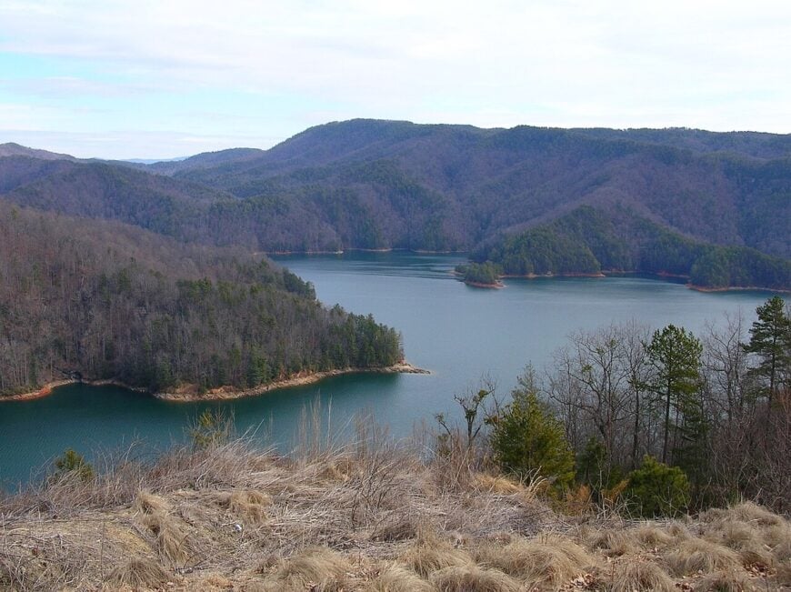
25. Newry – Mill Village by the Quiet Water

Newry feels like a page pressed between the leaves of the Blue Ridge foothills—brick mill houses, shade trees, and the low murmur of water slipping toward Lake Keowee. Its seclusion comes from winding backroads and the protective fold of the Little River, which keeps noise and speed at bay.
The vibe is nostalgic and neighborly, with ivy on brick and porches set close to the sidewalk. Explore the old mill site, launch a canoe on the calm backwaters, or wander gravel lanes where crickets take over at dusk.
Anglers test the coves; photographers chase golden hour on weathered brick. Small businesses and lake-season rentals provide a gentle economic pulse. It’s the kind of place where a single bell can fill the afternoon.
Where is Newry?

Tucked in northern Oconee County near the Little River arm of Lake Keowee, Newry sits roughly 10 miles north of Seneca and 15 miles west of Clemson. You reach it by slipping off SC-130 onto narrower local roads that drift toward the water.
The route bends through hardwoods and past pasture edges before the mill village appears. It’s close enough for groceries, but far enough that the lake and trees do most of the talking.
24. Six Mile – Ridge-to-Ridge Farm Country

Six Mile spreads across soft ridges where barns outnumber stoplights and mornings begin with fog lifting off bottomland fields. It feels secluded because the town is threaded by two-lane roads and guarded by the Blue Ridge escarpment just to the north.
The vibe is friendly, farm-forward, and outdoorsy. Hike to the Eastatoe Creek overlooks, pick peaches in season, or bike quiet stretches of SC-133 and SC-186.
Grab a plate at a local diner and listen to stories that travel slowly. Agriculture and small trades anchor the pace here. The hills make even a short drive feel like a small adventure.
Where is Six Mile?

You’ll find it in northeastern Pickens County, about 10 miles north of Clemson and 9 miles east of Liberty. SC-133 is the main thread, with smaller farm roads fanning out into hollows and ridges.
Approaches are curvy, shaded, and scenic. By the time you reach town, your shoulders have already dropped.
23. Pumpkintown – Where the Foothills Start to Breathe

Pumpkintown sits where the Piedmont exhales into mountains—wide porches, old oaks, and the scent of woodsmoke on cool evenings. Its seclusion is shaped by distance from interstates and the way SC-8 and SC-135 meander through pasture and pine.
The vibe is cheerfully rustic: produce stands, church suppers, and trailheads not far away. Spend a morning at nearby Table Rock State Park, drive the Cherokee Foothills Scenic Byway, or hunt waterfalls on short forest hikes.
Autumn brings roadside pumpkins and cider; summer brings lightning bugs by the thousands. Work here is a blend of farming, crafts, and park-season tourism. It’s the kind of quiet that sticks to your clothes.
Where is Pumpkintown?

Located in northern Pickens County, Pumpkintown lies roughly 10 miles north of Pickens and 20 miles west of Travelers Rest. Most folks arrive via SC-8 or SC-135, both gentle two-lane routes.
The last miles roll through fields and into tree tunnels. It’s near everything outdoors but hidden from the rush.
22. Rocky Bottom – Switchbacks and Starlight

Rocky Bottom is a ridgeline hamlet you find by listening for the wind; the map shows a name, the mountains do the rest. Its isolation comes courtesy of SC-178’s climbing switchbacks and national forest on nearly every side.
The vibe is cabin-simple and trail-friendly—porch chairs, stacked firewood, and boots by the door. Hike segments of the Foothills Trail, birdwatch along creek crossings, or roll a motorcycle up the 178 curves.
Evenings belong to the crickets and an unbothered Milky Way. Local livelihoods are a patchwork: forestry, guiding, and caretaking cabins. It’s the kind of high quiet that clears the head.
Where is Rocky Bottom?

Perched in the far north of Pickens County near the North Carolina line, it’s about 18 miles north of Pickens and 15 miles west of Caesars Head. Access is mainly via SC-178, a narrow mountain road that rewards patience.
Expect hairpins, overlooks, and long shadows across the asphalt. You arrive with the feeling you’ve crossed a threshold.
21. Fair Play – Where Lake Hartwell Meets the Pines

Fair Play drapes itself along the upper arms of Lake Hartwell, where coves reach deep into piney hillsides and roads end in boat ramps. Its seclusion comes from being tucked in the far western edge of the Upstate, where the Georgia line is just a short paddle away.
The vibe is lakefront-leisure with a rural backbone—fishing boats at dawn, farm stands in summer, and quiet porches year-round. Spend a morning casting for bass, explore hidden coves by kayak, or take a slow drive down orchard-lined lanes.
Seasonal visitors swell the numbers slightly, but full-time life remains low-key. Retirees, anglers, and small farms form the local rhythm. It’s the sort of place where the biggest decision is which cove to watch the sunset from.
Where is Fair Play?

Perched in the southwest corner of Oconee County, Fair Play sits just off I-85 near the South Carolina–Georgia border. The main turnoff drops you onto two-lane roads that snake toward the lake’s far reaches.
Seneca is about 15 miles north, though most errands can wait until after the day’s fishing. The air here smells like water and pine, and the quiet sticks with you long after you leave.
20. Dacusville – Pastures, Porches, and Peach Light

Dacusville feels like a landscape painting: rolling pastures, tidy barns, and a two-lane ribbon that never hurries. Its removed feeling comes from being set well off major corridors, with farms buffering the roads from any hint of bustle.
The vibe is agrarian, proud, and quietly creative. Browse a roadside market, pedal the gentle grades, or photograph hay bales at sunset. A seasonal festival or two brings neighbors together without changing the pace.
Farming, farrier work, and local trades keep the community humming. Even the dogs nap like they’ve got all afternoon.
Where is Dacusville?

Situated in eastern Pickens County, it’s roughly 12 miles northwest of Easley and 20 miles west of Travelers Rest. SC-186 and a patchwork of farm roads take you in.
Expect long fence lines and distant blue ridges. It’s close enough for errands yet wrapped in countryside calm.
19. Slater – Mill Shadows on the North Saluda

🔥 Would you like to save this?
Slater is a quiet mill village folded into bends of the North Saluda River, where red-brick row houses sit under old maples. Seclusion lingers because the hills mute traffic and the river corridor keeps development threaded and narrow.
The vibe is work-worn and welcoming: mill history, porch chats, and river walks. Stroll the old mill grounds, cast for bream where the current slows, or detour to nearby trails along the North Saluda watershed.
Early mornings bring mist rising off the water and the clack of a single screen door. Local work has shifted from textiles to small shops and commuting, but the village heartbeat remains slow. It’s a place built for unhurried days.
Where is Slater?

In far northern Greenville County, Slater sits just north of Marietta along US-276 and the river. You reach it via a short jog off the main road, where streets narrow and shade takes over.
The mountains pinch the valley into a pocket. Blink and you’ll miss it—unless you were looking for it.
18. Landrum – Blue Wall Porch Light

Landrum rests under the Blue Wall—the abrupt rise of the Blue Ridge—glowing at dusk with porch lights and the clink of dinnerware. It feels secluded because it orients more toward horse farms and mountain trails than toward highways.
The vibe is equestrian-elegant with a frontier edge: antique storefronts, farmer’s markets, and trailheads within easy reach. Wander the shops, visit nearby Tryon or TIEC events across the line, or hike the Blue Wall Preserve for long views.
Cyclists ride shady loops; birders gather at spring migration. Local life blends stables, small eateries, and weekend visitors with cameras. It’s small, but the sky feels big.
Where is Landrum?

Perched at the northern tip of Spartanburg County near the North Carolina border, Landrum is about 30 miles north of Spartanburg. US-176 and a short hop from I-26 bring you close before you drop into slower streets.
Country lanes peel off toward farms and foothill coves. In minutes, traffic thins to the sound of hooves and wind.
17. Campobello – Apples, Barns, and Blue Ridges

Campobello sits on open ground with apple rows marching toward the horizon and a faint blue mountain line beyond. Its tucked-away feel comes from the distance to interstates and the patchwork of orchards that hold the landscape together.
The vibe is farm-fresh and earnest—produce stands, church steeples, and tractors trundling home at dusk. Pick apples, hunt sunflowers for photos, or roll a bike along SC-11’s gentle curves. A small café or two keeps conversation going.
Agriculture is the backbone, with stables and roadside markets filling out the week. It’s the sort of quiet that tastes like honey and dust.
Where is Campobello?

You’ll find it in northern Spartanburg County, 10 miles east of Landrum and 12 miles northwest of Inman. The Cherokee Foothills Scenic Byway (SC-11) and SC-357 are your gateways.
Roads here are two-lane, shaded, and pleasantly indirect. Arrive unhurried, leave the same way.
16. Fingerville – Mill Dam Echoes

Fingerville gathers along the North Pacolet River, where the remains of old mill works still shape the current. Its seclusion comes from being tucked between low ridges, with narrow roads that dip and rise through timber stands.
The vibe is humble and river-bound: clapboard houses, a country store, and kids skipping stones at the shallows. Fish the pools below the dam site, walk quiet lanes at golden hour, or detour to nearby foothill parks.
The soundtrack is water over rock and the occasional pickup crossing the bridge. Work is a mix of commuting, small trades, and a few farms. It’s a short chapter of river that reads longer than it looks.
Where is Fingerville?

Set in northern Spartanburg County between Inman and the state line, Fingerville lies a few bends off SC-11 and SC-9. Access comes by way of county roads that favor the river’s path.
Expect one-lane bridges and shade in every direction. The last turn feels like you’ve slipped behind a curtain.
15. Jonesville – Porch-Swing Piedmont

Jonesville is a little grid of streets, deep porches, and slow afternoons where conversations last as long as the shade holds. It feels secluded because it sits off the main drags, wrapped by farmland and pine barrens.
The vibe is small-town classic—historic storefronts, a tidy library, and Friday night lights in the fall. Browse antiques, cast a line at a nearby pond, or loop quiet backroads that rise and fall like breath.
Bluebirds own the fence posts; cicadas own the soundtrack. Local work blends small manufacturing with agriculture and mom-and-pop shops. It’s the kind of place that reminds you to sit a spell.
Where is Jonesville?

Situated in eastern Union County, it’s roughly 12 miles east of Union and 25 miles south of Spartanburg. SC-9 and SC-18 get you close before smaller streets slow you down.
The drive is all two-lane, calm, and with field edges. You’ll know you’ve arrived when the pace changes.
14. Lockhart – Bridge to the Broad

Lockhart hangs over the Broad River on a narrow bridge where water, rails, and history converge. Seclusion is guaranteed by the river’s broad sweep and state forest lands that keep things green and quiet.
The vibe is mill-ghosted and river-bright: brick remnants, sycamores, and anglers working slow eddies. Walk the bridge for big-sky views, paddle a lazy reach of the river, or scout the old canal traces.
Evenings smell like damp stone and sun-warmed iron. A few shops and commuting jobs sustain locals. It’s a small town with a wide horizon.
Where is Lockhart?

At the northern edge of Union County near the Chester line, Lockhart sits directly on the Broad River. Most arrive via SC-49 or SC-9 and a final set of bends toward the bridge.
The approach tightens as the river takes over the view. On the span, everything else falls away.
13. Lowrys – Pastures and Parade Country

🔥 Would you like to save this?
Lowrys is a scatter of farmhouses, pasture gates, and one famous country parade that seems to pause time each winter. Its seclusion stems from distance to interstates and the protective quilt of cattle land around it.
The vibe is homespun and cheerful—feed stores, tin roofs, and porch flags that crack lightly in the breeze. Tour scenic backroads for barn photography, chase bluebird trails, or time a visit with a modest festival day.
Even at “busy,” it’s never busy. Cattle and hay anchor the ledger here. It’s the kind of place where the sky looks bigger than the town itself.
Where is Lowrys?

In northern Chester County along US-321, Lowrys sits about 7 miles north of Chester and well west of I-77. You’ll exit the interstate early and finish the trip on straight, quiet pavement.
Fields open like pages on both sides. The stillness starts before the town sign.
12. Sharon – Oaks, Steeples, and Slow Roads

Sharon keeps to a handful of streets shaded by old oaks, with steeples that seem to hold up the sky. It feels tucked away because the nearest four-lane is a good detour and the surrounding farms keep everything spaced out.
The vibe is timeless—front porches, one café, and a calendar that revolves around church suppers and school plays. Drive to nearby nature preserves, wander past historic homes, or explore quiet parklands on the edge of town.
Owls speak up before traffic ever does. Small shops, farms, and commuting make up the workweek. It’s a gentle whisper of a place.
Where is Sharon?

You’ll find it in western York County, about 12 miles southwest of York and 20 miles east of Blacksburg. SC-49 and county roads thread through fields and woodlots to get you there.
Expect slow curves and little signage. The final mile feels like dialing down the volume.
11. Smyrna – South Carolina’s Little Secret

Smyrna is tiny enough to count the porch lights and still have fingers to spare, which is part of its charm. Seclusion comes naturally here—straddling county lines and surrounded by pine and pasture, it’s well off any fast route.
The vibe is hush-quiet and neighborly: a post office, a cluster of homes, and a pace that treats time like a guest. Photograph old barns at sunrise, explore nearby country parks, or just let the crickets narrate a summer evening.
There’s not much commerce, which is precisely the point. Folks work the land or commute and come home to stillness. It’s close to everywhere and miles from it all.
Where is Smyrna?

Set near the York–Cherokee County line in the state’s far north, Smyrna sits roughly 10 miles west of York and 10 miles south of Kings Mountain country. The approach is a braid of two-lane roads—no quick cut-throughs, just curves and hedgerows.
You’ll slow down without meaning to. When the stars come out, there’s nothing to compete with them.
10. Tamassee – Blue Ridge Foothill Hideaway

Roughly 1,100 people call Tamassee home, though most reside on widely spaced farmsteads rather than in a tight town center. Morning drives skirt hayfields where bluebirds light on weathered fence posts, and afternoons invite paddles on nearby Lake Jocassee or hikes to Moody Creek Falls.
Agriculture and heritage tourism—the latter boosted by the historic Tamassee DAR School—support the modest local economy. Small cattle operations and niche organic farms occupy the bottomlands, yet you’ll find no chain stores or traffic lights for miles.
Cell service flickers in and out, adding to the sense that time stalls beneath the Blue Ridge backdrop. The distance between neighbors and the surrounding Sumter National Forest create a buffer of trees that muffles both sound and hurry.
Where is Tamassee?

Tamassee rests in north-central Oconee County, wedged between Lake Jocassee to the west and Highway 11 to the south. Encircling ridges block radio towers and funnel morning fog across the valley floor, helping preserve its hush.
Travelers usually exit SC-11 onto SC-130, then follow gravel lanes past century-old barns before signage for Tamassee appears. Greenville is an hour southeast, but after the last gas station in Walhalla, winding pavement and forest vistas reinforce the retreat.
9. Long Creek – Chattooga River Backcountry

With a population hovering near 250, Long Creek feels more like a scattering of orchards than a village. Visitors fill baskets at Chattooga Belle Farm, sample cider slushies, then head downhill for Class IV rapids on the Wild & Scenic Chattooga River.
Apple growing remains the primary industry, supplemented by white-water guiding and a smattering of vacation rentals. Main Street is a two-lane blacktop lined with produce stands that close when the peaches run out.
Dense hardwood ridges shield the community from sightlines and cell towers, making sunsets over the river gorge eerily silent. No streetlamps reach the orchard rows, so stargazing becomes an impromptu nightly event.
Where is Long Creek?

🔥 Would you like to save this?
Long Creek occupies South Carolina’s northwestern tip, bordered on two sides by Georgia and framed by the Ellicott Rock Wilderness. The Chattooga River’s 1,000-foot-deep gorge isolates the hamlet from major highways, leaving SC-76 as the only paved artery.
From Westminster it’s 16 miles of switchbacks before orchards appear, and winter storms can close the route entirely. This single-road access keeps traffic to locals, farmers, and river kayaks strapped to roof racks.
8. Mountain Rest – Forest Service Cabin Country

Approximately 1,400 residents are scattered across 50,000 acres of mixed oak and hemlock forest in Mountain Rest. Outdoor days pivot between trout fishing on the Chauga River, chasing waterfalls at King Creek Falls, and renting 1930s Civilian Conservation Corps cabins near Oconee State Park.
Local income flows from seasonal tourism, small sawmills, and Forest Service contracts. Commercial signage is limited to hand-painted directions to trout ponds or a single café, the nostalgic Chattooga River Lodge & Campground.
Dense public land on every flank blocks expansion, and the steep gravel roads deter casual pass-through traffic. Even chain saws sound faint beneath the cathedral-like canopy, adding to the settlement’s near-wilderness feel.
Where is Mountain Rest?

The settlement sits along SC-107 in northern Oconee County, about 12 miles north of Walhalla. National forest tracts ring the area, leaving only two paved approaches and numerous dirt spurs that dead-end at trailheads.
Reaching it from Greenville takes 90 minutes and an ascent up hair-pin turns that follow ridge lines above Lake Keowee. Without broadband or reliable cell coverage, many cabins rely on satellite dishes, reinforcing the backcountry mood.
7. Cleveland – Scenic Highway 11’s Quiet Pocket

Cleveland counts just over 900 residents, many living on acreage parcels tucked behind Table Rock’s looming granite face. Hiking the Palmetto Trail, photographing Carrick Creek Falls, and casting a line in the Middle Saluda River top daily agendas.
Small-scale timber and seasonal hospitality—mostly cottage rentals and one country store—comprise local commerce. The absence of subdivisions keeps property lines defined by stone walls older than the state park itself.
Thick ridges shield the valley from Highway 11’s weekend traffic, letting cicadas out-sing engines by dusk. With no sidewalks, visitors quickly learn the only rush hour involves wild turkeys crossing the road at dawn.
Where is Cleveland?

Located in northern Greenville County, Cleveland lies two miles north of the Highway 11–SC-8 junction, sandwiched between Table Rock State Park and Caesars Head. The settlement hides behind bends where the Saluda River cuts a notch in the foothills, leaving it invisible to most park traffic.
Access comes via SC-288, a two-lane stretch of asphalt that climbs and falls through tree tunnels. Once past the post office, cell bars vanish and the forest reins in every sound but wind and water.
6. Sunset – Carolina Sky Island

Sunset’s roughly 1,300 inhabitants share elevated pastureland perched 1,400 feet above sea level on the Pickens County escarpment. Days start with horseback rides over dew-soaked grass and often end with kayaks on 400-acre Lake Keowee’s quieter north coves.
Real-estate closings and boutique equestrian farms form the modest economic base, complemented by a single farm-to-table restaurant in a converted gristmill. Because homes sit on multi-acre lots, neighbors are usually distant silhouettes behind morning fog.
Outdoor lighting ordinances protect local observatories, so Milky Way sightings are common if clouds cooperate. The combination of high elevation, limited road network, and protected night sky keeps Sunset feeling like a sky island adrift above the Piedmont.
Where is Sunset?

Sunset occupies the western rim of Pickens County near the South Carolina–North Carolina line, bounded by SC-11 to the south and Lake Jocassee to the west. Winding back roads force motorists to snake around Cove Creek Valley, elongating even short drives.
From Pickens, SC-178 climbs 15 miles through switchbacks before cresting at the community’s single gas pump. Public transit never reaches this altitude, leaving personal vehicles—or road bikes for the hardy—as the lone way in.
5. Gowensville – Foothills Farmland Retreat

Home to about 2,400 residents, Gowensville lies in a quilt of hayfields and shaded creeks where farmhouses date to the 1880s. Cyclists gather at the historic Gowensville Spire for rides along the Cherokee Foothills Scenic Byway, while foodies stop for artisanal cheeses and fresh produce at the nearby farmers’ markets in Landrum and Tryon.
Pasture-based dairies, horse boarding, and weekend agritourism drives the local economy. Development pressure from nearby Greer is kept at bay by strict zoning and land-trust easements.
Evening silence is broken only by whip-poor-wills and the distant hum of tractors winding down. The flat valley floor framed by low ridges hides homes from view, lending photographs a timeless southern-rural look free of powerlines or cul-de-sacs.
Where is Gowensville?

Sitting at the northern tip of Greenville County, Gowensville centers on the crossroads of SC-14 and Highway 11. The Blue Ridge foothills rise abruptly to the north, forming a scenic wall that screens the area from both I-26 and US-25 traffic.
Reaching the community from Greenville involves a 40-minute drive through peach orchards and cow pastures with just one traffic signal en route. No public bus routes cover this rural wedge, so visitors rely on cars or bicycles to arrive and explore.
4. Tigerville – Hidden Valley near Glassy Mountain

Tigerville’s population hovers around 1,300, swelled slightly by students at North Greenville University, the town’s tiny collegiate centerpiece. Weekends feature hikes up Glassy Mountain, swims in Campbell Creek, and photography of the historic Poinsett Bridge—the oldest surviving stone bridge in the state.
Academia and small-scale cattle grazing share the economic load, punctuated by seasonal festivals on the campus quadrangle. One-lane bridges and crumbling mill dams speak to a past steeped in textile history, long since quieted.
Thick hardwoods carpet surrounding slopes, concealing almost every roofline and muting city glow from Greenville 25 minutes away. The sheltered valley and the lack of commercial corridors make Tigerville feel like a hidden annex of the mountain backdrop.
Where is Tigerville?

Nested between Glassy Mountain and Paris Mountain in northern Greenville County, Tigerville sits just east of SC-414. The encircling ridgelines block through-traffic, forcing cars to slow on blind curves and deterring commuters in a hurry.
Most travelers exit US-25, wind uphill for seven miles, then descend into the university clearing where cell reception finally returns. Limited roads out mean darkness deepens quickly, favoring night skies that belie the community’s proximity to Greenville.
3. Pauline – Back Roads of Spartanburg County

Pauline claims about 950 residents spread among oak-lined gravel drives, vintage country stores, and clapboard churches that date to the Civil War era. Lazy afternoons might include fishing at Lake Blalock, browsing antiques at the Storehouse, or photographing the wrought-iron cemetery gates of Trough Shoals.
Farming—chiefly soybeans and hay—joins a handful of home-based artisans to underpin the local economy. A single flashing light marks downtown, and postal addresses often reference rural route numbers rather than streets.
Thick stands of loblolly pine shield homesteads from passing cars, lending a feeling of private acreage even along public roads. The 15-mile gap to Spartanburg’s city limits keeps skyglow low and traffic counts lower.
Where is Pauline?

The hamlet sits south-southwest of Spartanburg just off SC-56, hemmed in by the Tyger River to the west and Lawson’s Fork Creek to the east. Two-lane farm roads loop around cotton fields, making direct paths rare and GPS signals fickle.
Drivers usually exit I-26 at either Walnut Grove or SC-215, then meander past unmarked crossroads before a modest “Pauline” sign appears. Absent public transit, the only reliable arrival is by personal vehicle, though the Swamp Rabbit cycling club occasionally pedals through on charity rides.
2. Blackstock – Civil War Hamlet on the Broad River

Only 200 or so residents remain in Blackstock, a once-bustling depot town that straddles Chester and Fairfield counties. Visitors wander past the abandoned Seaboard Air Line Railroad station, snap photos of the 19th-century Baptist church, and cast lines for catfish on secluded Broad River sandbars.
Cattle farms and timber leases form the town’s scant economic lifeblood, supplemented by a small heritage museum that opens on request. With empty cotton gins and silent rails, the streets often feel paused mid-century, making nightfall especially still.
Massive bottomland hardwoods flank the Broad River, acting as a natural curtain that hides the settlement from SC-215 traffic. Faded storefronts and unmarked dirt lanes underscore the remoteness of a place bypassed by progress.
Where is Blackstock?

Blackstock lies roughly halfway between Chester and Winnsboro along SC-215, yet sits three miles east of that roadway down a spur that dead-ends at the river. The Broad River’s floodplain and adjacent timber tracts deter development and keep GPS navigation spotty.
Columbia is an hour south, but the final 15 minutes involve pothole-pocked tarmac and a one-lane bridge. Without rail service since 1980 and no bus lines, residents depend on pickup trucks—and sometimes jon boats—to reach stores in Great Falls or Chester.
1. Salem – Gateway to Lake Jocassee’s Quiet Coves

Salem hosts fewer than 150 full-time residents, many living in cedar-clad cabins overlooking the sapphire waters of Lake Jocassee. Days revolve around paddle-in waterfalls such as Wright Creek Falls, guided fly-fishing for smallmouth bass, and sunset swims at remote Laurel Fork.
A handful of outfitters and the Keowee-Toxaway power station anchor the slim economic base, complemented by seasonal vacation rentals. Nights find locals stargazing from the boat ramp where loons echo across glass-calm water.
The absence of commercial strip lighting, paired with miles of undeveloped shoreline protected by Duke Energy, keeps the ambiance hushed. With more black bears than billboards, Salem tops our list for Southern Appalachian solitude.
Where is Salem?

This hamlet occupies the extreme northwest corner of Oconee County, reachable via SC-130 after leaving Highway 11 near the Jocassee Dam. Tall knobs and the 7,500-acre lake form a natural amphitheater that blocks radio and cellular signals, deepening the sense of removal.
From Clemson, the 45-minute journey ends at a single gas station where the pavement narrows to the Jocassee Gorges entrance road. Once across the dam, visitors rely on gravel tracks, pontoon boats, or hiking boots—modern reminders that Salem remains intentionally off the grid.