🔥 Would you like to save this?

Best counties to live in Missouri
More counties in the United States experienced population growth in the last year, according to the latest Census data, even as pandemic-related moving trends begin to normalize.
Counties in the South continued to experience growth, particularly in Florida, where 96% of its 67 counties gained new residents. Polk County, Florida, a suburb of Orlando, added the most, with 26,000 people moving there in 2023.
In order to come up with the very specific design ideas, we create most designs with the assistance of state-of-the-art AI interior design software. Also, assume links that take you off the site are affiliate links such as links to Amazon. this means we may earn a commission if you buy something.
Meanwhile, counties in the Midwest and Northeast continued to lose population, but at slower rates than the year before. Some of the biggest losses were in counties home to large cities, including Cook County, Illinois (home of Chicago) and the boroughs of Brooklyn and Queens in New York.
Many counties are experiencing growth due to their job opportunities, education, or relatively affordable housing costs. Others are favored for their historic or well-designed downtowns or access to cultural opportunities.
Stacker compiled a list of the best counties to live in Missouri using rankings from Niche. Niche ranks counties by various factors including public schools, educational attainment, cost of living, and housing.
Keep reading to see if your county made the list.
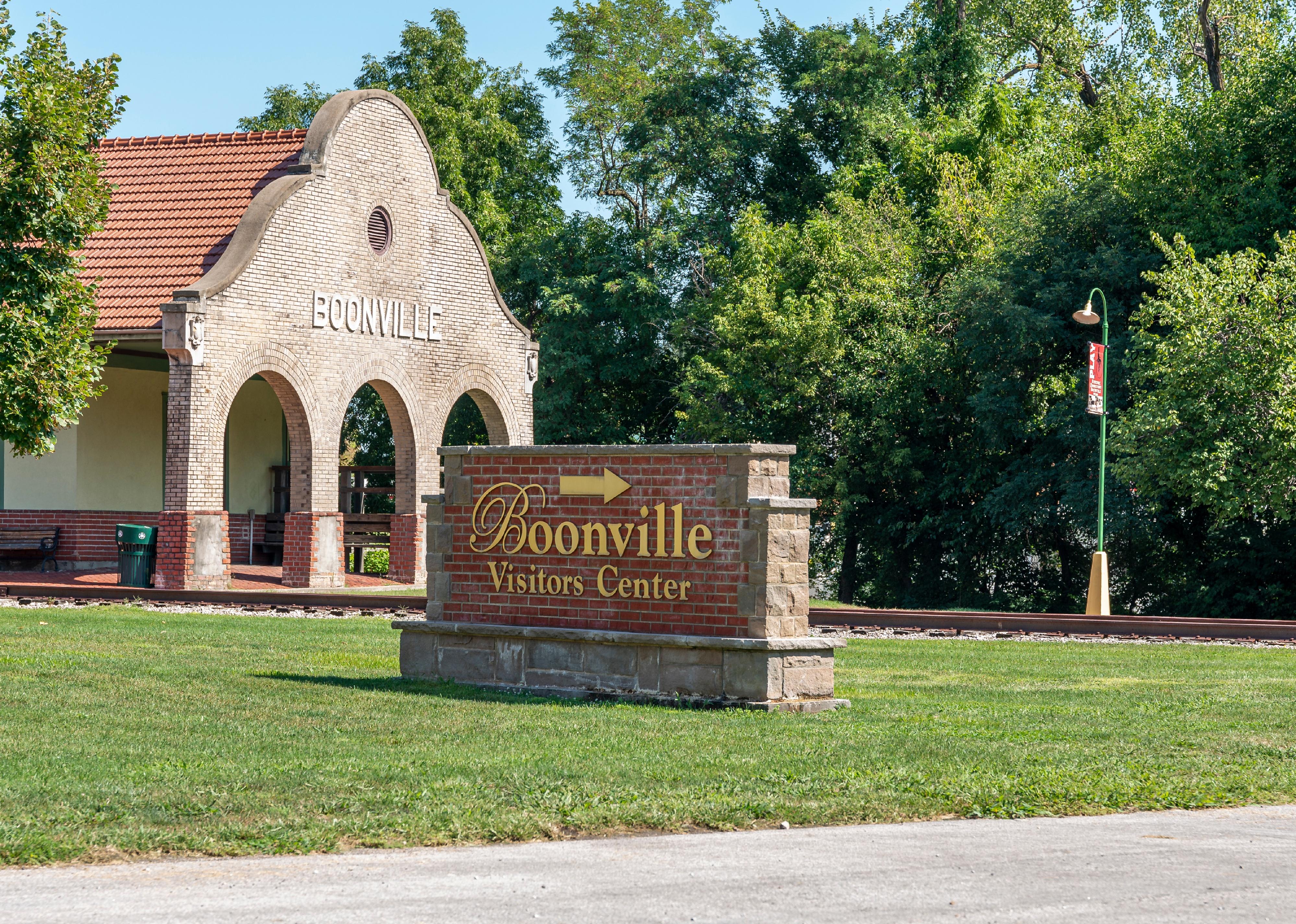
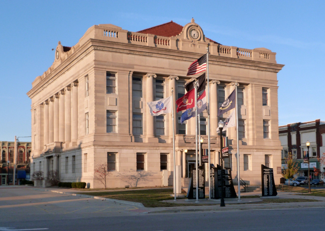
#30. Cooper County, Missouri
– Overall Rank: 1,205
– Population: 16,893
– Median household income: $62,239
– Median home value: $168,200 (77% own)
– Median rent: $724 (23% rent)
– Top public schools: Boonville High School (grade B), Pilot Grove Elementary School (grade B), Bunceton Elementary School (grade B minus)
– Top private schools: Ss. Peter & Paul School (grade unavailable), St. Joseph Elementary School (grade unavailable), Zion Lutheran School (grade unavailable)
– Top places: Boonville (grade B+), Saline Township (grade B+), Boonville Township (grade B)
About
Cooper County is a rural community with an economy rooted in agriculture, small businesses, and local services that support daily life. The area values tradition, family, and a strong sense of community pride. Residents enjoy a quiet lifestyle supported by schools, healthcare access, and civic organizations.
County government provides essential services such as emergency response, infrastructure maintenance, and public safety. Cultural events, local fairs, and recreational opportunities bring people together and celebrate community identity. Cooper County continues to support steady growth while preserving its rural character and heritage.
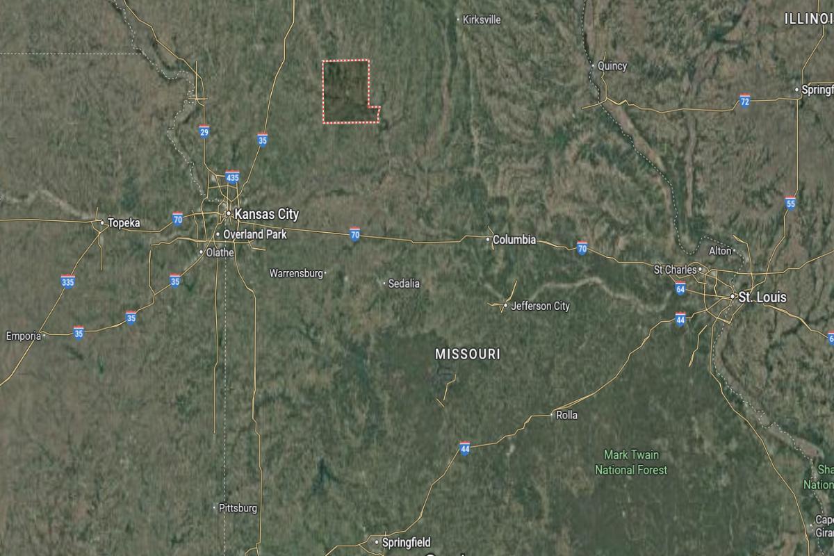
Where is Cooper County?
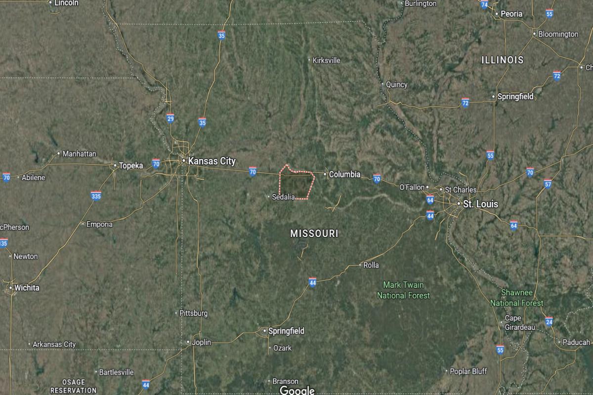
Cooper County is located in central Missouri, within the state’s rolling hills and river valley region. It lies about 40 miles west of Columbia and approximately 90 miles east of Kansas City. The county seat, Boonville, is near the Missouri River and accessible via I-70 and US Highway 40.
The county is roughly 75 miles north of Springfield and about 120 miles west of St. Louis. It also sits around 55 miles south of Moberly. Cooper County’s location offers easy access to major cities and central transportation routes across Missouri.
#29. Miller County, Missouri
– Overall Rank: 1,154
– Population: 24,855
– Median household income: $53,490
– Median home value: $164,900 (75% own)
– Median rent: $726 (25% rent)
– Top public schools: Eldon Middle School (grade A minus), Eldon Upper Elementary School (grade B+), Osage High School (grade B+)
– Top private schools: Our Lady of the Snows School (grade unavailable), Lakeview Christian Academy (grade unavailable)
– Top places: Lake Ozark (grade A minus), Eldon (grade B), St. Elizabeth (grade A minus)
About
Miller County has a balanced economy supported by agriculture, tourism, and small businesses that reflect its rural roots and natural attractions. The community is known for its welcoming atmosphere, strong family values, and connection to local traditions. Residents benefit from essential services, educational opportunities, and a peaceful way of life.
County government provides key operations such as law enforcement, infrastructure maintenance, and emergency response. Recreational activities, local festivals, and scenic landscapes contribute to a strong sense of place and community pride. Miller County remains focused on preserving its heritage while encouraging thoughtful development and community well-being.
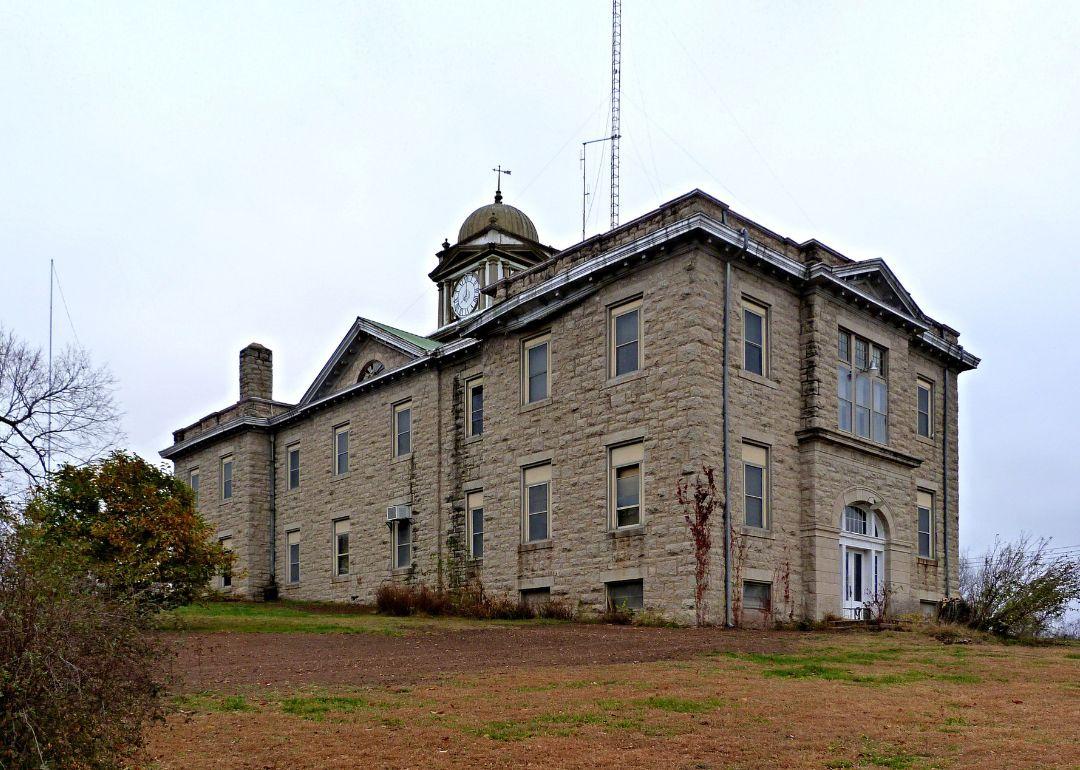
Where is Miller County?
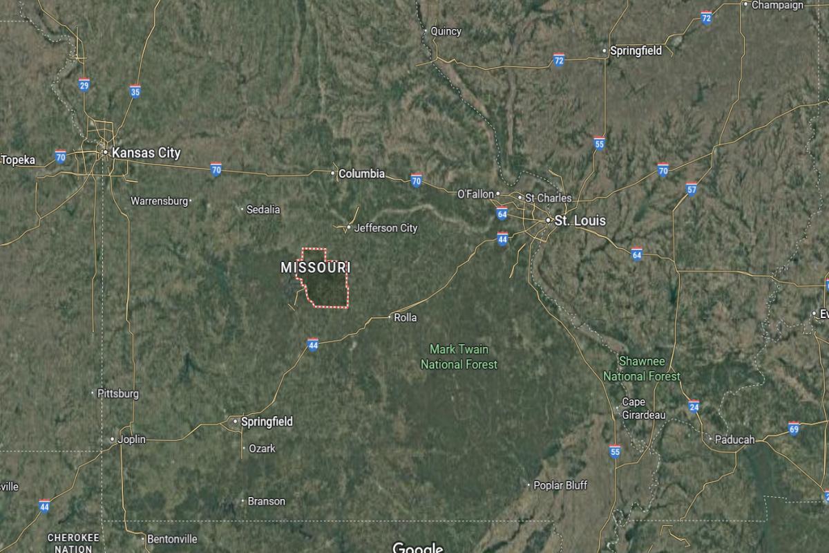
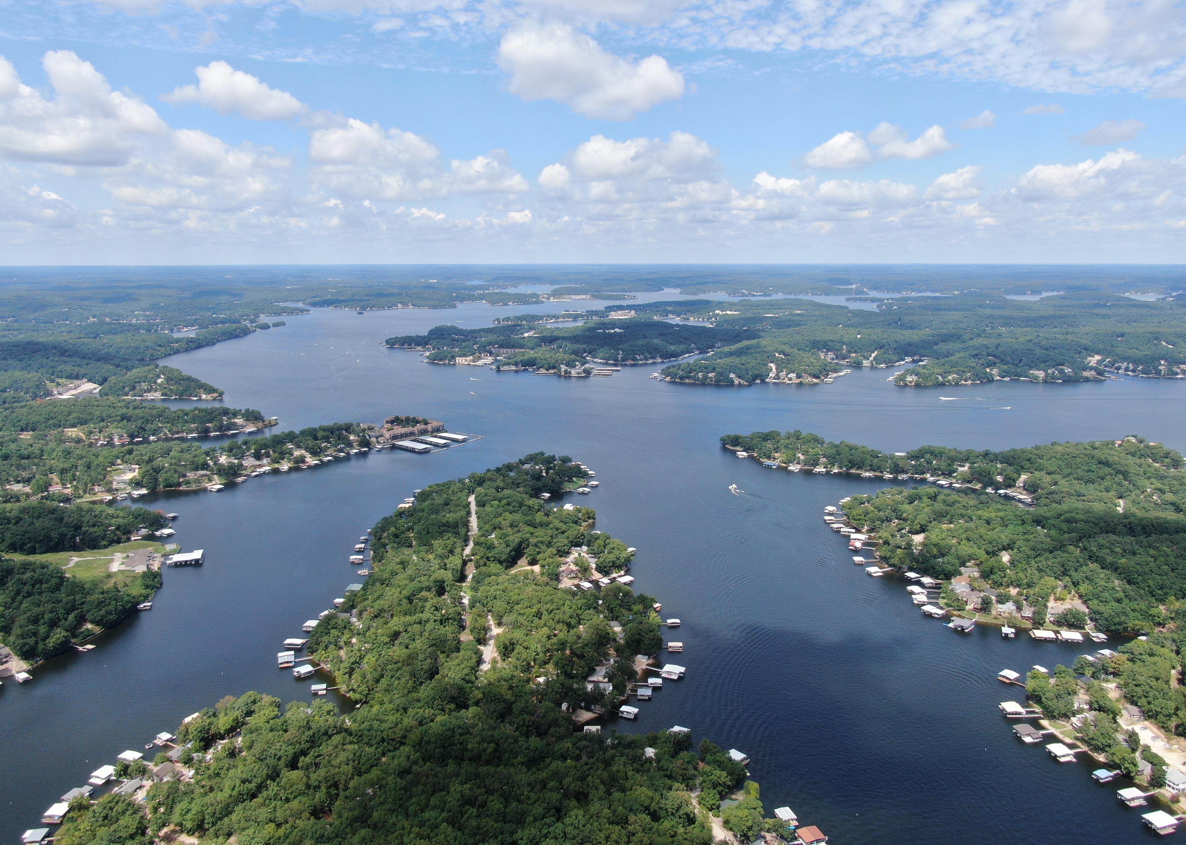
Miller County is located in central Missouri, near the Lake of the Ozarks region. It lies about 40 miles southwest of Jefferson City and approximately 60 miles southeast of Columbia. The county seat, Tuscumbia, is accessible via State Highways 52 and 17.
The county is roughly 85 miles northeast of Springfield and about 135 miles west of St. Louis. It also sits around 95 miles southeast of Sedalia. Miller County’s location places it near popular recreational areas and key routes in central Missouri.
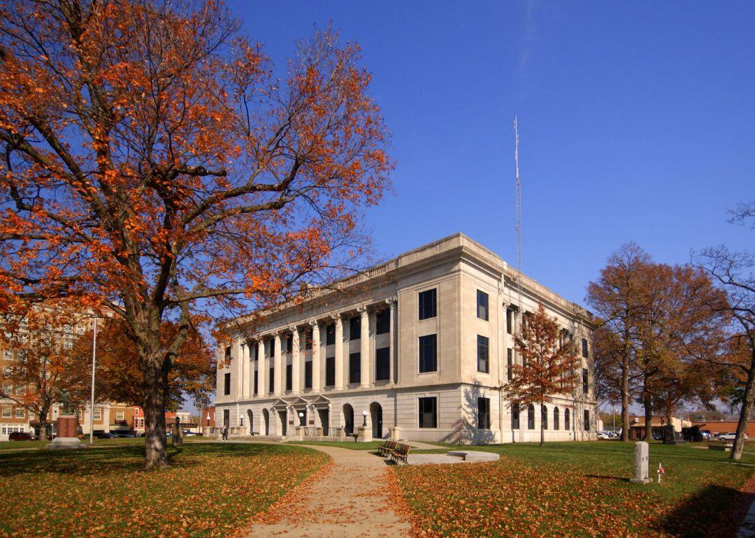
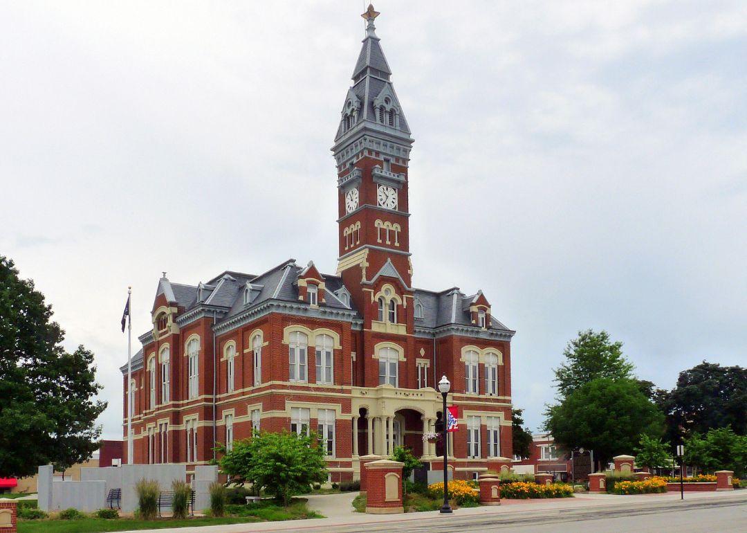
#28. Pettis County, Missouri
– Overall Rank: 1,143
– Population: 43,059
– Median household income: $57,581
– Median home value: $150,000 (70% own)
– Median rent: $838 (30% rent)
– Top public schools: Hardeman Elementary School (grade A minus), Horace Mann Elementary School (grade A minus), Parkview Elementary School (grade A minus)
– Top private schools: Sacred Heart School (grade A minus), Applewood Christian School (grade A minus), Show-Me Christian School (grade B minus)
– Top places: Sedalia (grade B), Green Ridge (grade A minus), Prairie Township (grade B+)
About
Pettis County features a diverse economy rooted in agriculture, manufacturing, and service industries that support both urban and rural communities. The area is known for its strong work ethic, educational institutions, and commitment to community development. Residents benefit from accessible healthcare, public services, and a blend of small-town charm with regional connectivity.
County government oversees essential services including emergency management, law enforcement, and infrastructure maintenance. Cultural events, local fairs, and recreational facilities contribute to a vibrant and engaged community life. Pettis County continues to grow while maintaining its traditions and supporting the needs of its residents.
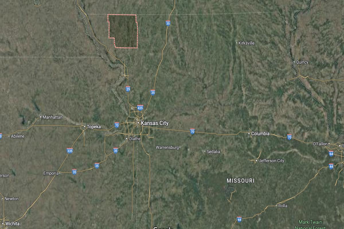
Where is Pettis County?
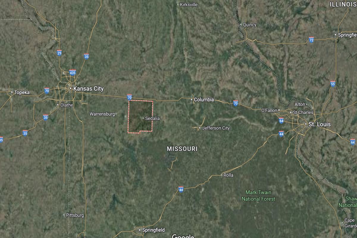
Pettis County is located in central Missouri, within a region of farmland and small towns. It lies about 30 miles west of Jefferson City and approximately 90 miles east of Kansas City. The county seat, Sedalia, is near the junction of US Highway 50 and State Highway 65.
The county is roughly 60 miles south of Columbia and about 120 miles northwest of Springfield. It also sits around 100 miles west of St. Louis. Pettis County’s location provides access to major cities and transportation routes across mid-Missouri.
#27. Chariton County, Missouri
– Overall Rank: 1,142
– Population: 7,417
– Median household income: $61,910
– Median home value: $121,000 (82% own)
– Median rent: $525 (18% rent)
– Top public schools: Brunswick Elementary School (grade B+), Brunswick High School (grade B), Northwestern Elementary School (grade B)
– Top private schools: St. Joseph School (grade unavailable)
– Top places: Brunswick (grade B+), Brunswick Township (grade B+), Salisbury (grade B)
About
Chariton County is grounded in agriculture, with farming and livestock operations providing the core of its local economy and identity. The community is characterized by close-knit relationships, family-oriented values, and reliable public services including schools and healthcare. Residents take pride in their heritage and a simple, steady way of life.
County government oversees vital services such as road and bridge maintenance, emergency response, and public safety. Community events, local gatherings, and access to outdoor spaces foster engagement and a strong sense of belonging. Chariton County remains focused on preserving its rural traditions while providing for steady, community-centered progress.
Where is Chariton County?
🔥 Would you like to save this?
Chariton County is located in north-central Missouri, within the state’s rural farmland region. It lies about 60 miles northwest of Columbia and approximately 90 miles northeast of Kansas City. The county seat, Keytesville, is near State Highways 5 and 24.
The county is roughly 75 miles north of Jefferson City and about 115 miles southeast of St. Joseph. It also sits around 135 miles west of Hannibal. Chariton County’s location places it in a quiet, central area with access to regional towns and river routes.
#26. Cass County, Missouri
– Overall Rank: 1,127
– Population: 108,205
– Median household income: $82,473
– Median home value: $242,300 (76% own)
– Median rent: $1,097 (24% rent)
– Top public schools: Timber Creek Elementary School (grade A minus), Creekmoor Elementary School (grade A minus), Stonegate Elementary School (grade B+)
– Top private schools: Heartland High School & Academy (grade B+), Blue Ridge Christian School (grade B), Training Center Christian School (grade unavailable)
– Top places: Lake Winnebago (grade A minus), Raymore (grade B+), Pleasant Hill (grade B+)
About
Cass County has a strong and growing economy supported by agriculture, manufacturing, healthcare, and small businesses. The community blends suburban development with rural character, offering a balanced lifestyle for families and individuals. Residents benefit from quality schools, public services, and a strong sense of civic pride.
County government provides essential services such as emergency management, law enforcement, and infrastructure maintenance. Community events, parks, and recreational opportunities enhance quality of life and foster engagement. Cass County continues to grow while preserving its traditions and focusing on sustainable development.
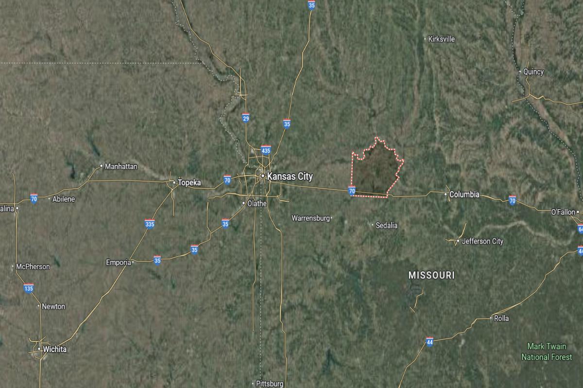
Where is Cass County?
Cass County is located in western Missouri, within the Kansas City metropolitan area. It lies about 30 miles south of downtown Kansas City and approximately 90 miles west of Jefferson City. The county seat, Harrisonville, is near the intersection of I-49 and State Highway 2.
The county is roughly 70 miles north of Joplin and about 65 miles southwest of Sedalia. It also sits around 120 miles northwest of Springfield. Cass County’s location provides convenient access to both metropolitan and rural areas in western Missouri.
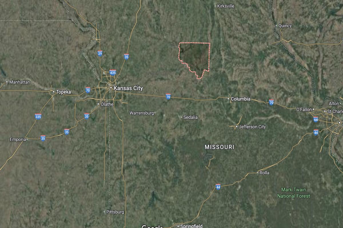
#25. Nodaway County, Missouri
– Overall Rank: 1,099
– Population: 21,140
– Median household income: $53,917
– Median home value: $157,200 (63% own)
– Median rent: $739 (37% rent)
– Top public schools: Jefferson Elementary School (grade A), Maryville Middle School (grade B+), Eugene Field Elementary School (grade B+)
– Top private schools: St. Gregory Barbarigo School (grade unavailable), Horace Mann Laboratory School (grade unavailable), Pleasant View (grade unavailable)
– Top places: Maryville (grade B+), Jefferson Township (grade A minus), Conception (grade B+)
About
Nodaway County has a balanced economy supported by agriculture, education, and small businesses that reflect its rural heritage and growing community needs. The presence of higher education institutions contributes to local employment, innovation, and cultural life. Residents value a strong work ethic, community involvement, and access to essential services.
County government provides vital operations including emergency response, infrastructure maintenance, and public safety. Parks, local events, and historic attractions foster connection and pride among residents. Nodaway County continues to promote steady growth while preserving its traditions and community-focused values.
Where is Nodaway County?
Nodaway County is located in the northwestern corner of Missouri, near the Iowa border. It lies about 95 miles north of Kansas City and approximately 35 miles west of Maryville, the county seat, which is along US Highway 71. The county is part of a largely rural and agricultural region.
The county is roughly 40 miles south of the Iowa state line and about 70 miles northeast of St. Joseph. It also sits around 115 miles northwest of Columbia. Nodaway County’s location places it in a quiet, rural part of Missouri with access to regional highways and nearby states.
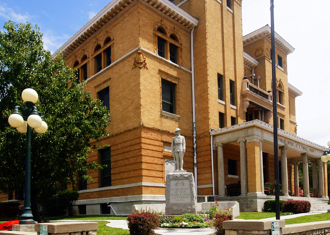
#24. Johnson County, Missouri
– Overall Rank: 1,097
– Population: 54,025
– Median household income: $62,503
– Median home value: $206,600 (63% own)
– Median rent: $912 (37% rent)
– Top public schools: Knob Noster Middle School (grade A minus), Knob Noster High School (grade A minus), Whiteman Air Force Base Elementary School (grade B+)
– Top private schools:
– Top places: Knob Noster (grade B+), Warrensburg (grade B+), Washington Township (grade B+)
About
Johnson County, Missouri is a region with deep agricultural roots and a strong community focus. It hosts the University of Central Missouri, which plays a key role in local education and cultural life. The county also has a history tied to Civil War events, shaping much of its heritage and local identity.
Economically, it balances traditional farming with newer industries such as manufacturing and education services. The presence of Whiteman Air Force Base adds both military significance and economic support to the area. Its small-town atmosphere, paired with growing infrastructure, creates a mix of rural charm and modern development.
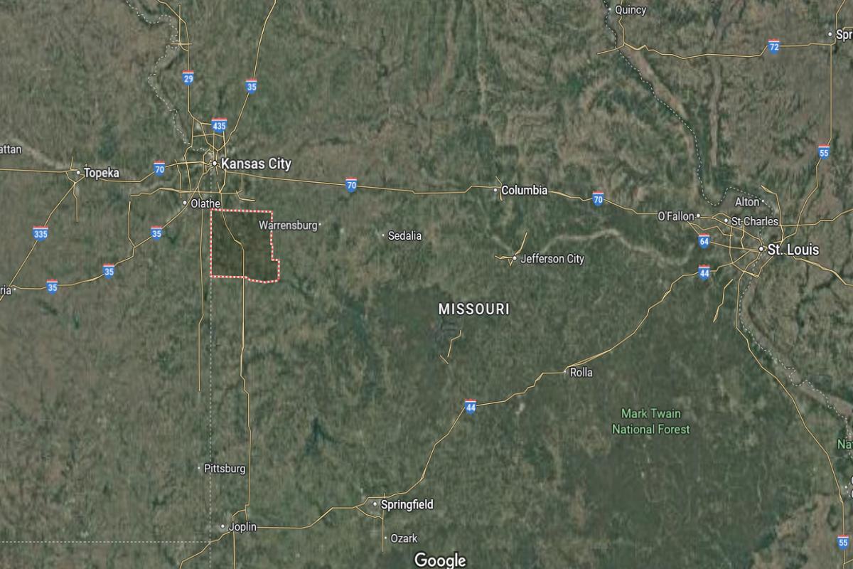
Where is Johnson County?
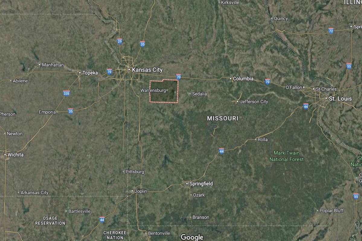
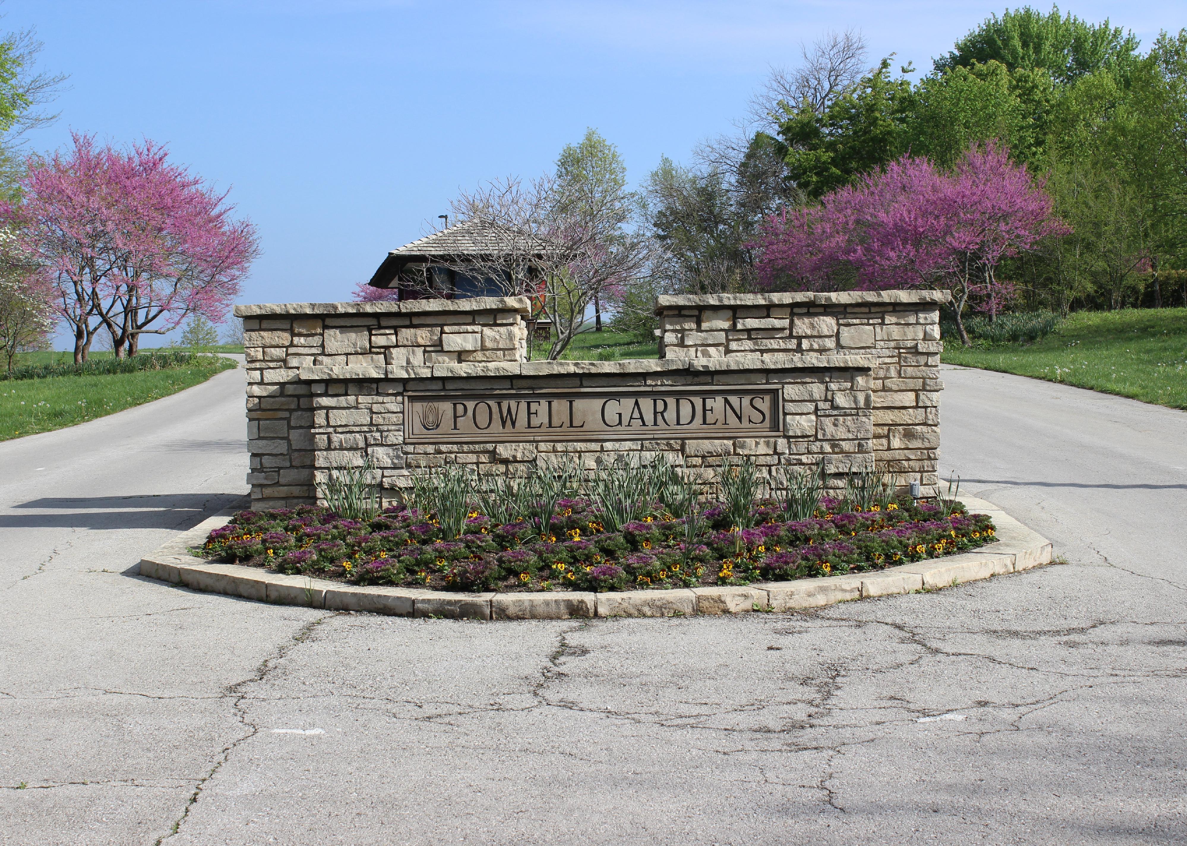
Johnson County is located in west-central Missouri, in a region of farmland and small communities. It lies about 60 miles southeast of Kansas City and approximately 50 miles west of Jefferson City. The county seat, Warrensburg, is near US Highway 50 and State Highway 13.
The county is roughly 35 miles south of Sedalia and about 90 miles northwest of Springfield. It also sits around 75 miles northeast of Joplin. Johnson County’s location offers access to key routes and regional centers across western Missouri.
#23. Linn County, Missouri
– Overall Rank: 1,048
– Population: 11,892
– Median household income: $58,435
– Median home value: $107,600 (77% own)
– Median rent: $648 (23% rent)
– Top public schools: Marceline Middle School (grade A), Walt Disney Elementary School (grade A minus), Brookfield Middle School (grade A minus)
– Top private schools: McCartan Memorial School (grade unavailable), Locust Creek Mennonite School (grade unavailable)
– Top places: Brookfield (grade B), Yellow Creek Township (grade A minus), Marceline Township (grade B+)
About
Linn County, Missouri features a landscape defined by rolling farmland, quiet towns, and a strong tradition of agriculture. Its economy is largely supported by farming, livestock production, and small-scale manufacturing. The county maintains a close-knit community culture centered around local events, fairs, and historical preservation.
It offers residents and visitors access to parks, lakes, and recreational activities tied to its rural setting. Historical landmarks and preserved sites reflect the area’s 19th-century origins and development. Despite its modest population, Linn County remains resilient through its connection to land, history, and community values.
Where is Linn County?
🔥 Would you like to save this?
Linn County is located in north-central Missouri, in a region of small towns and rural farmland. It lies about 65 miles north of Columbia and approximately 55 miles east of St. Joseph. The county seat, Linneus, is near US Highway 36 and State Highway 5.
The county is roughly 95 miles northeast of Kansas City and about 100 miles west of Hannibal. It also sits around 70 miles northwest of Jefferson City. Linn County’s location provides access to major highways and regional destinations across northern Missouri.
#22. Livingston County, Missouri
– Overall Rank: 1,040
– Population: 14,402
– Median household income: $58,772
– Median home value: $139,700 (70% own)
– Median rent: $755 (30% rent)
– Top public schools: Central Elementary School (grade A minus), Chillicothe High School (grade B+), Field Elementary School (grade B+)
– Top private schools: Bishop Hogan Memorial School (grade unavailable), Meadow View School (grade unavailable)
– Top places: Chillicothe (grade B+), Chillicothe Township (grade B), Blue Mound Township (grade B)
About
Livingston County, Missouri is known for its strong agricultural foundation and longstanding community traditions. Farming, livestock, and agribusiness are central to its economy, with local services and small industries supporting rural life. The county seat serves as a hub for government, commerce, and education within the region.
Civic pride is reflected in well-preserved historical sites, annual festivals, and active local organizations. Outdoor recreation is popular, with parks, trails, and nearby waterways providing opportunities for fishing, hiking, and family activities. The county blends rural charm with stable infrastructure and a focus on heritage and community resilience.
Where is Livingston County?
Livingston County is located in north-central Missouri, in a primarily rural and agricultural region. It lies about 90 miles northeast of Kansas City and approximately 70 miles northwest of Columbia. The county seat, Chillicothe, is near US Highways 36 and 65.
The county is roughly 55 miles southeast of St. Joseph and about 85 miles southwest of Kirksville. It also sits around 95 miles north of Jefferson City. Livingston County’s location provides key highway access across central and northern Missouri.

#21. Saline County, Missouri
– Overall Rank: 1,018
– Population: 23,219
– Median household income: $55,396
– Median home value: $129,600 (72% own)
– Median rent: $718 (28% rent)
– Top public schools: Sweet Springs Elementary School (grade B), Sweet Springs High School (grade C+), Marshall Senior High School (grade C+)
– Top private schools: St. Peter Catholic School (grade unavailable), Calvary Baptist School (grade unavailable)
– Top places: Marshall (grade B), Blackburn (grade B+), Marshall Township (grade B)
About
Saline County, Missouri is deeply rooted in agriculture, with fertile land supporting a mix of crops and livestock production. The local economy also benefits from education, healthcare, and small manufacturing sectors. Community life is shaped by traditions, school spirit, and civic engagement through festivals and local events.
Historical buildings, museums, and cultural landmarks reflect the county’s 19th-century origins and Civil War connections. Recreational spaces, including parks and nature areas, offer residents and visitors places to gather and explore. The county maintains a balance of rural heritage and modern services that support its close-knit population.
Where is Saline County?
Saline County is located in central Missouri, along the Missouri River Valley. It lies about 40 miles northwest of Columbia and approximately 85 miles east of Kansas City. The county seat, Marshall, is near US Highway 65 and State Highway 20.
The county is roughly 60 miles north of Jefferson City and about 95 miles southeast of St. Joseph. It also sits around 110 miles west of Hannibal. Saline County’s location offers access to major highways and connects rural areas to key urban centers.
#20. Atchison County, Missouri
– Overall Rank: 984
– Population: 5,270
– Median household income: $58,521
– Median home value: $96,100 (72% own)
– Median rent: $608 (28% rent)
– Top public schools: Rock Port Elementary School (grade A minus), Fairfax Elementary School (grade B+), Tarkio High School (grade B)
– Top private schools:
– Top places: Rock Port (grade B+), Tarkio (grade B+), Clay Township (grade B+)
About
Atchison County, Missouri is defined by its agricultural roots, with vast farmland dedicated to crops like corn and soybeans. Small towns throughout the county reflect a strong sense of community and tradition, where local events and gatherings are central to daily life. The economy is supported by farming, small businesses, and regional services.
Historical landmarks, scenic landscapes, and quiet roads contribute to the county’s rural charm. Residents enjoy outdoor activities such as hunting, fishing, and exploring local parks and trails. Despite its small population, the county maintains a stable infrastructure and a deep connection to its heritage.
Where is Atchison County?
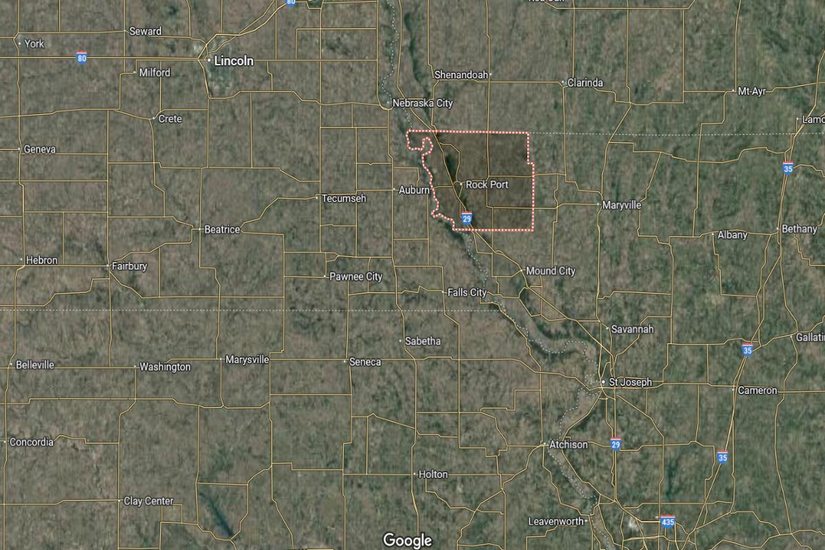
🔥 Would you like to save this?
Atchison County is located in the northwestern corner of Missouri, bordering both Iowa and Nebraska. It lies about 115 miles north of Kansas City and approximately 50 miles northwest of St. Joseph. The county seat, Rock Port, is near I-29 and US Highway 136.
The county is roughly 40 miles west of Maryville and about 80 miles southeast of Omaha, Nebraska. It also sits around 140 miles northwest of Columbia. Atchison County’s location places it at a tri-state junction with key access to regional highways and rural communities.
#19. Newton County, Missouri
– Overall Rank: 889
– Population: 59,019
– Median household income: $60,313
– Median home value: $162,900 (74% own)
– Median rent: $781 (26% rent)
– Top public schools: George Washington Carver Elementary School (grade B+), Neosho Junior High School (grade B+), Seneca Intermediate School (grade B+)
– Top private schools: Neosho Christian Schools (grade unavailable), Trinity Learning Center (grade unavailable), Racine Apostolic Christian School (grade unavailable)
– Top places: Neosho (grade B+), Leawood (grade A), Shoal Creek Township (grade A minus)
About
Newton County, Missouri blends agricultural strength with industrial development, making it a key contributor to the regional economy. Its towns support a variety of local businesses, schools, and community events that reflect a blend of tradition and growth. Manufacturing, farming, and retail sectors play a significant role in everyday life.
Natural features like rivers, forests, and parks provide spaces for recreation and environmental appreciation. The county also values its historic roots, preserving buildings and sites that tell the story of its past. With strong community ties and diverse economic activity, it offers both stability and a connection to rural heritage.
Where is Newton County?
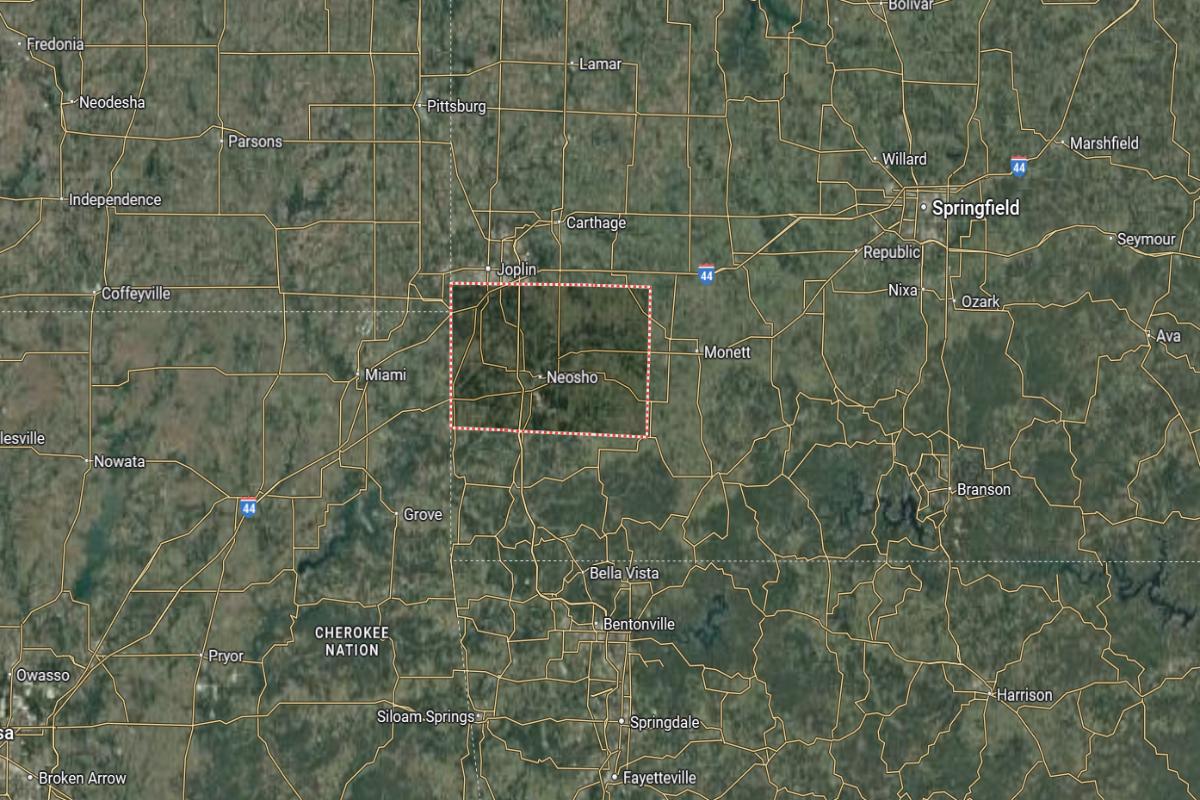
Newton County is located in the southwestern corner of Missouri, near the borders with Kansas and Oklahoma. It lies about 15 miles south of Joplin and approximately 80 miles west of Springfield. The county seat, Neosho, is near US Highways 60 and 71.
The county is roughly 15 miles east of the Kansas state line and about 25 miles northeast of Miami, Oklahoma. It also sits around 150 miles south of Kansas City. Newton County’s location provides access to multiple states and regional transportation routes in the Four-State Area.
#18. Callaway County, Missouri
– Overall Rank: 835
– Population: 44,517
– Median household income: $70,599
– Median home value: $184,300 (77% own)
– Median rent: $807 (23% rent)
– Top public schools: North Elementary School (grade B+), South Callaway Elementary School (grade B+), Bartley Elementary School (grade B)
– Top private schools: St. Peter Catholic School (grade unavailable), Kingdom Christian Academy (grade unavailable), Callaway Child and Family Development Center (grade unavailable)
– Top places: Holts Summit (grade B+), Fulton (grade B), Summit Township (grade A minus)
About
Callaway County, Missouri is a region rich in historical significance, with a strong agricultural base and active community life. Its economy benefits from farming, manufacturing, and educational institutions, creating a balanced mix of rural and industrial contributions. Local towns host events, festivals, and civic gatherings that strengthen community identity.
The county is home to preserved historical sites, scenic byways, and recreational areas that highlight its natural and cultural assets. Outdoor activities like hiking, boating, and wildlife observation are popular among residents and visitors alike. With a blend of heritage, economic resilience, and natural beauty, the county fosters a grounded and vibrant way of life.
Where is Callaway County?
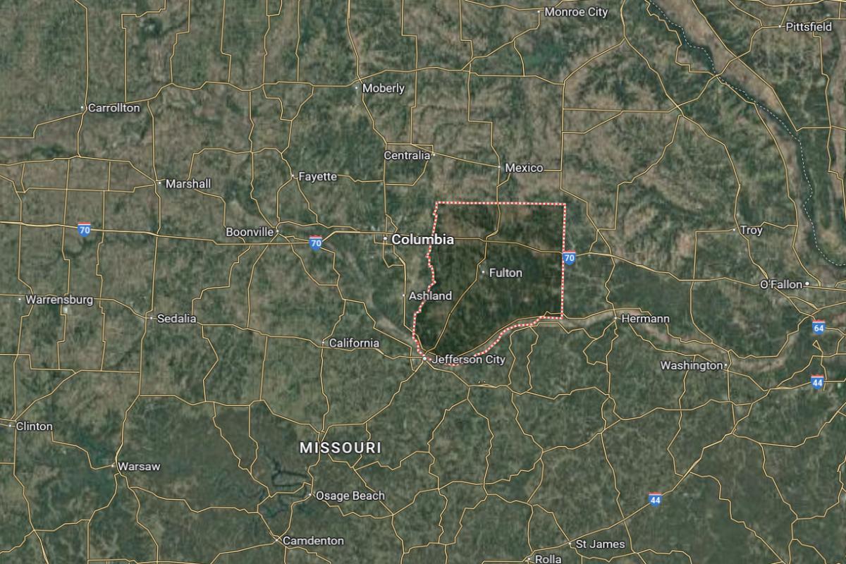
Callaway County is located in central Missouri, along the northern edge of the Missouri River. It lies about 25 miles northeast of Jefferson City and approximately 30 miles southeast of Columbia. The county seat, Fulton, is near US Highway 54 and State Highway 94.
The county is roughly 95 miles west of St. Louis and about 120 miles east of Kansas City. It also sits around 60 miles south of Moberly. Callaway County’s location places it between key urban centers and within reach of major highways in central Missouri.
#17. Buchanan County, Missouri
– Overall Rank: 644
– Population: 84,544
– Median household income: $58,303
– Median home value: $149,600 (63% own)
– Median rent: $856 (37% rent)
– Top public schools: Ellison Elementary School (grade B+), East Buchanan Middle School (grade B+), Oak Grove Elementary School (grade B+)
– Top private schools: Bishop LeBlond High School (grade B+), St. Joseph Christian School (grade B+), St. Francis Xavier School (grade unavailable)
– Top places: St. Joseph (grade B minus), Platte Township (grade A minus), Tremont Township (grade B+)
About
Buchanan County, Missouri features a dynamic mix of urban amenities and rural landscapes, supported by a diverse economy that includes healthcare, manufacturing, and education. Its communities are active in the arts, sports, and civic life, offering a rich blend of culture and tradition. Historical architecture and vibrant local businesses reflect both heritage and growth.
The county also offers access to green spaces, recreational trails, and riverfront areas that support outdoor lifestyles. Events, festivals, and museums contribute to a strong sense of local pride and identity. With deep historical roots and ongoing development, it remains a central hub of activity and culture in the region.
Where is Buchanan County?
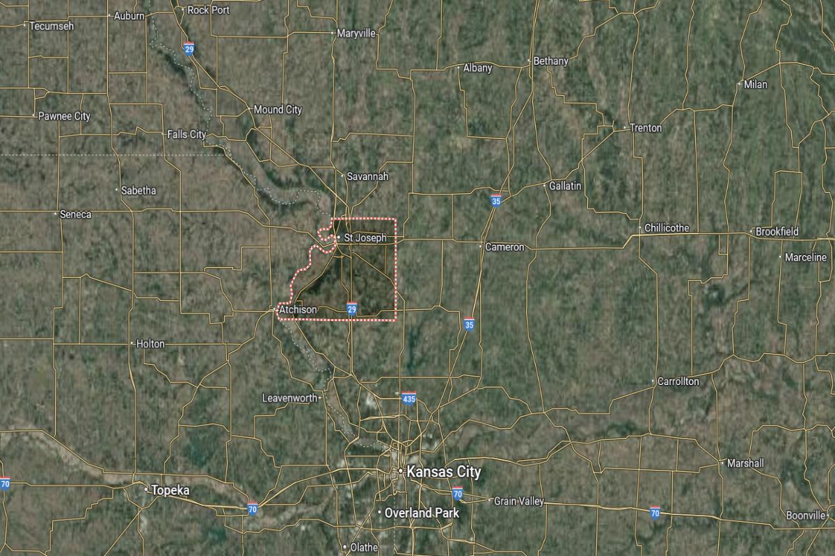
Buchanan County is located in northwestern Missouri, along the Missouri River. It lies about 55 miles north of Kansas City and approximately 95 miles northwest of Jefferson City. The county seat, St. Joseph, is near I-29 and US Highway 36.
The county is roughly 65 miles west of Chillicothe and about 120 miles northeast of Topeka, Kansas. It also sits around 100 miles south of the Iowa border. Buchanan County’s location provides strong regional access to highways, river routes, and nearby states.
#16. Jasper County, Missouri
– Overall Rank: 595
– Population: 122,788
– Median household income: $54,963
– Median home value: $147,500 (63% own)
– Median rent: $878 (37% rent)
– Top public schools: Eugene Field Elementary School (grade A), Harry S Truman Elementary School (grade A), Mark Twain Elementary School (grade A)
– Top private schools: Thomas Jefferson Independent Day School (grade A+), McAuley Catholic High School (grade A minus), College Heights Christian School (grade A minus)
– Top places: Carl Junction (grade A minus), Oronogo (grade A minus), Webb City (grade A minus)
About
Jasper County, Missouri is a center of industry, commerce, and culture, blending historical charm with modern economic activity. Manufacturing, mining, and retail form the backbone of its economy, supported by a network of schools, businesses, and healthcare facilities. Local communities celebrate their heritage through festivals, art scenes, and preserved landmarks.
Natural features like trails, parks, and caves attract residents and visitors for outdoor recreation and exploration. The county fosters a strong civic spirit, with active participation in public events, education, and volunteer programs. It remains a vibrant area rooted in tradition while embracing growth and diversity.
Where is Jasper County?
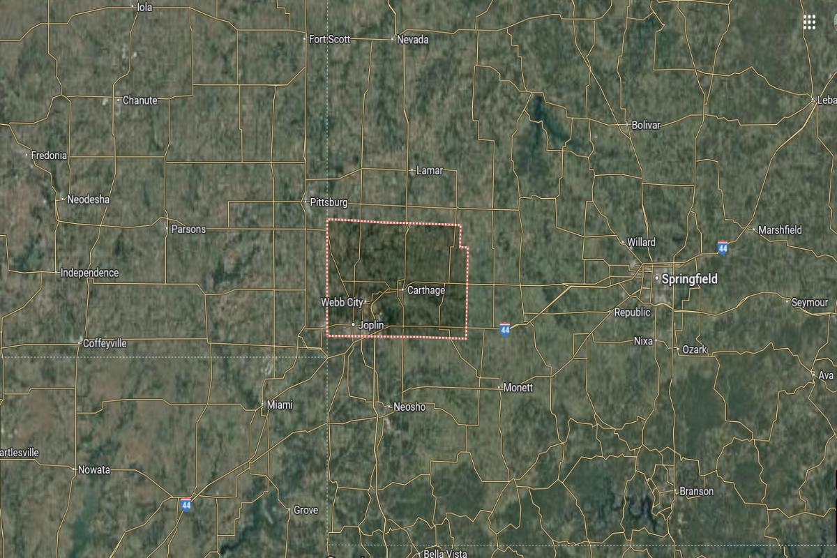
Jasper County is located in the southwestern corner of Missouri, near the Kansas state line. It lies about 10 miles north of the Oklahoma border and approximately 70 miles west of Springfield. The county seat, Carthage, is near I-49 and US Highway 71.
The county is roughly 5 miles east of the Kansas border and about 20 miles northeast of Miami, Oklahoma. It also sits around 150 miles south of Kansas City. Jasper County’s location places it in a key transportation and industrial region near multiple state borders.
#15. Taney County, Missouri
– Overall Rank: 588
– Population: 56,202
– Median household income: $54,467
– Median home value: $175,100 (67% own)
– Median rent: $873 (33% rent)
– Top public schools: Kirbyville Elementary School (grade A), Buchanan Elementary School (grade A), Mark Twain Elementary School (grade A)
– Top private schools: Trinity Christian Academy (grade A minus), School of the Ozarks (grade B+), Riverview Bible Baptist Christian School (grade unavailable)
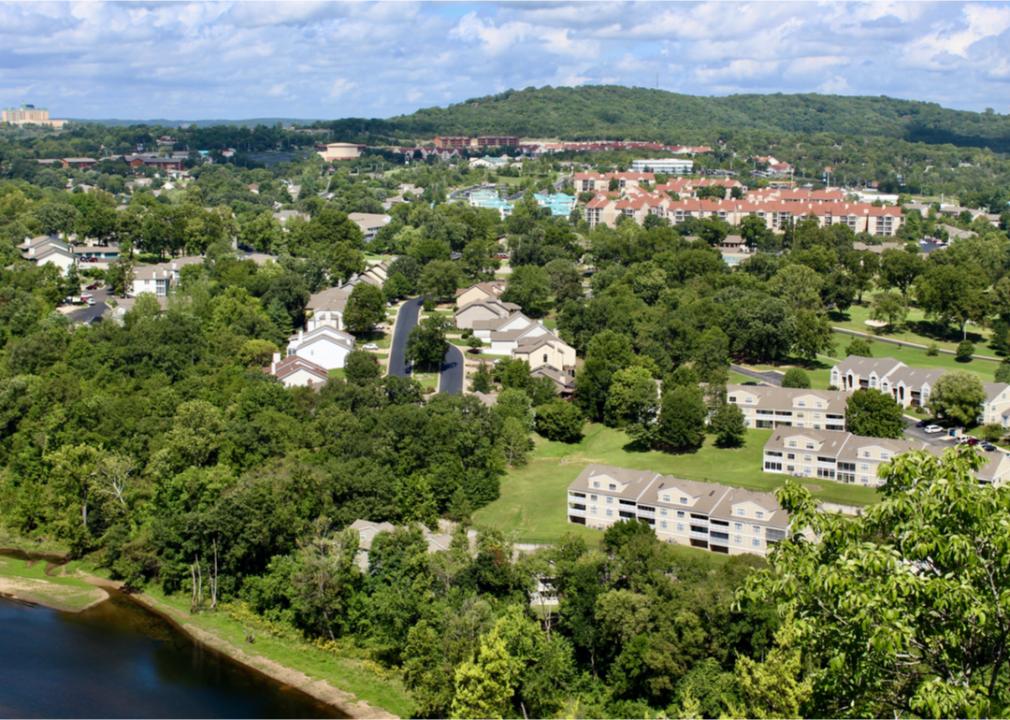
– Top places: Branson (grade A minus), Hollister (grade B+), Forsyth (grade B)
About
Taney County, Missouri is known for its thriving tourism industry, entertainment venues, and scenic beauty. The local economy thrives on hospitality, retail, and outdoor recreation, with a strong focus on visitor services and seasonal attractions. Communities in the area are deeply involved in cultural events, music, and family-friendly activities.
The landscape includes hills, lakes, and forests that support hiking, boating, and wildlife experiences. Historical sites and theaters contribute to the area’s rich cultural identity and regional draw. With its blend of natural charm and entertainment-driven energy, the county balances tourism with community values and everyday living.
Where is Taney County?
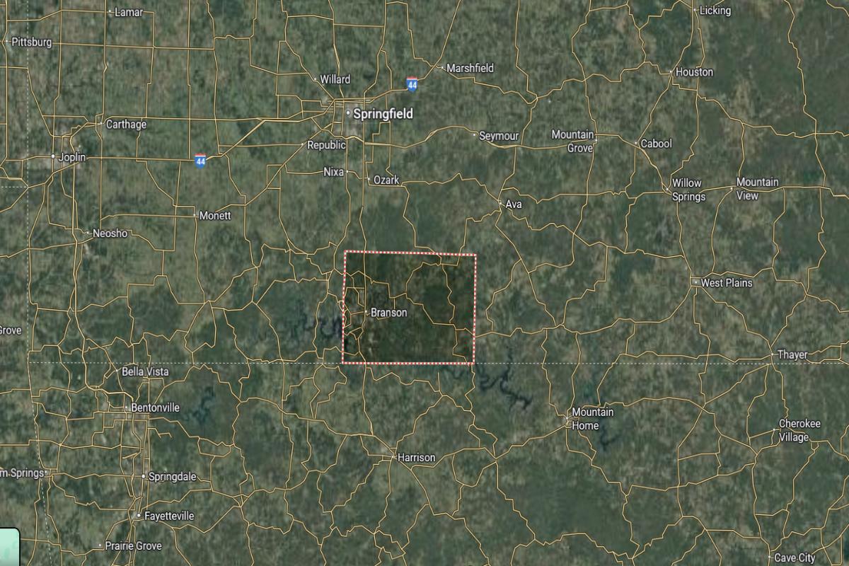
Taney County is located in the southwestern part of Missouri, within the Ozark Mountains region. It lies about 45 miles south of Springfield and approximately 20 miles north of the Arkansas border. The county seat, Forsyth, is near US Highway 160 and State Highway 76.
The county is roughly 55 miles southeast of Joplin and about 80 miles northwest of Mountain Home, Arkansas. It also sits around 190 miles south of Jefferson City. Taney County’s location places it in a scenic and hilly area known for tourism and outdoor recreation.
#14. Adair County, Missouri
– Overall Rank: 514
– Population: 25,299
– Median household income: $51,020
– Median home value: $146,700 (62% own)
– Median rent: $758 (38% rent)
– Top public schools: Adair County R-II School (grade B+), Ray Miller Elementary School (grade B)
– Top private schools: Life Church School (grade A), Faith Lutheran School (grade unavailable), Mary Immaculate Elementary School (grade unavailable)
– Top places: Kirksville (grade B+), Benton Township (grade B+), Wilson Township (grade B+)
About
Adair County, Missouri features a balanced mix of education, healthcare, and agriculture as key components of its economy. The presence of a major university adds cultural depth, research opportunities, and youthful energy to the region. Local communities are active in the arts, public events, and civic engagement.
The county offers scenic rural landscapes, parks, and trails that support outdoor recreation and environmental appreciation. Historical landmarks and cultural institutions reflect a commitment to preserving local heritage. With its combination of academic influence and rural tradition, Adair County maintains a vibrant and resilient character.
Where is Adair County?
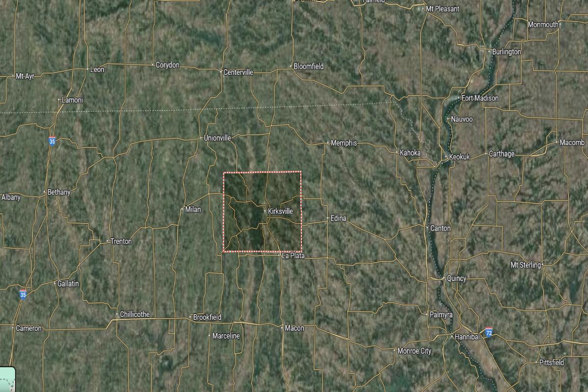
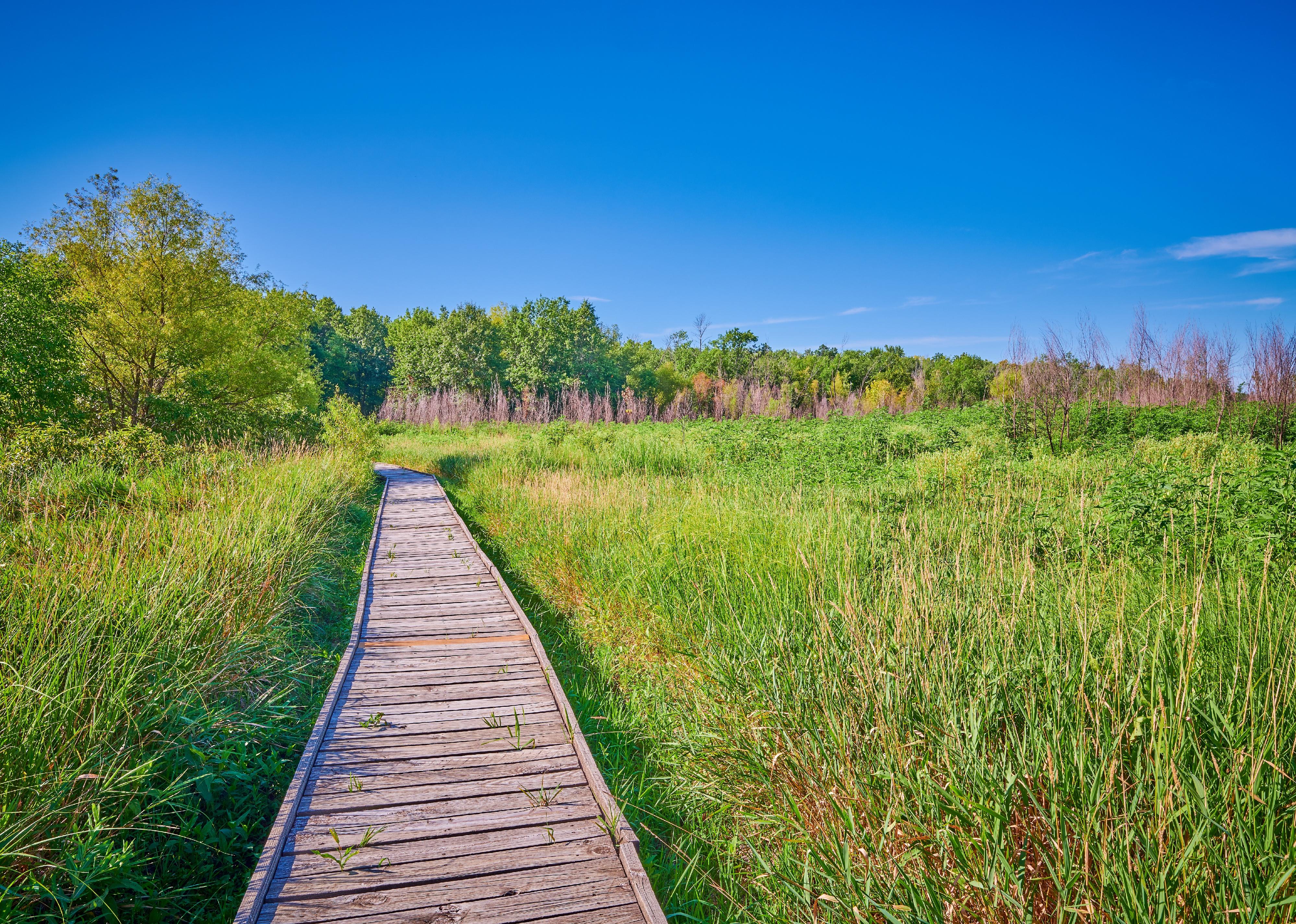
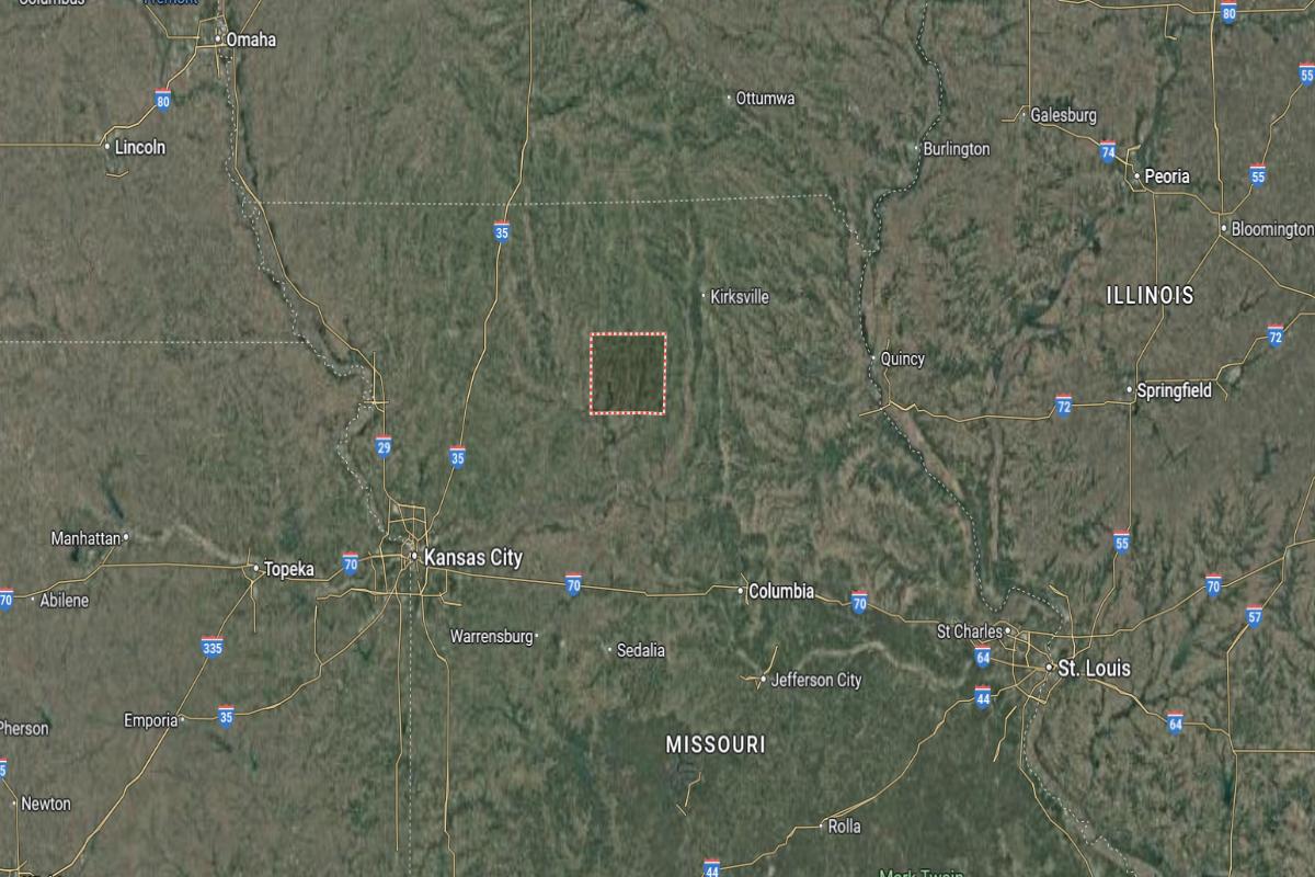
Adair County is located in northeastern Missouri, in a region of rolling hills and rural communities. It lies about 90 miles north of Columbia and approximately 40 miles south of the Iowa border. The county seat, Kirksville, is near US Highways 63 and 136.
The county is roughly 85 miles west of Quincy, Illinois, and about 115 miles northeast of Jefferson City. It also sits around 125 miles northwest of St. Louis. Adair County’s location provides access to both in-state and out-of-state destinations in the Midwest.
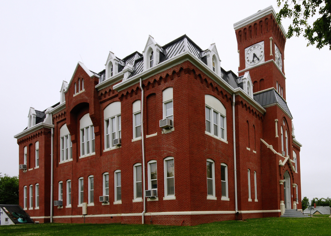
#13. Marion County, Missouri
– Overall Rank: 476
– Population: 28,525
– Median household income: $62,492
– Median home value: $150,900 (69% own)
– Median rent: $757 (31% rent)
– Top public schools: Oakwood Elementary School (grade A minus), Palmyra Elementary School (grade A minus), Monroe City Middle School (grade B+)
– Top private schools: Holy Family School (grade unavailable), St. John’s Lutheran School (grade unavailable), Hannibal Christian Academy (grade unavailable)
– Top places: Palmyra (grade A minus), Hannibal (grade B), Fabius Township (grade A)
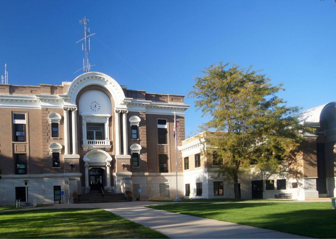
About
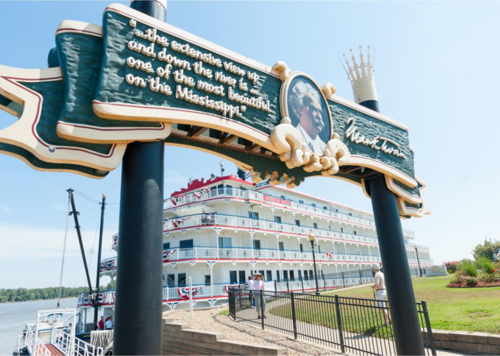
Marion County, Missouri is rich in historical legacy, with strong ties to literature, river commerce, and early American life. Its economy is supported by manufacturing, agriculture, and tourism, creating a stable and diverse foundation. Communities in the area celebrate local history through museums, festivals, and cultural events.
The county features scenic river views, historic districts, and family-friendly attractions that draw visitors year-round. Residents enjoy a blend of small-town charm and access to modern services and amenities. With deep cultural roots and active civic life, Marion County offers a unique mix of heritage and everyday vibrancy.
Where is Marion County?
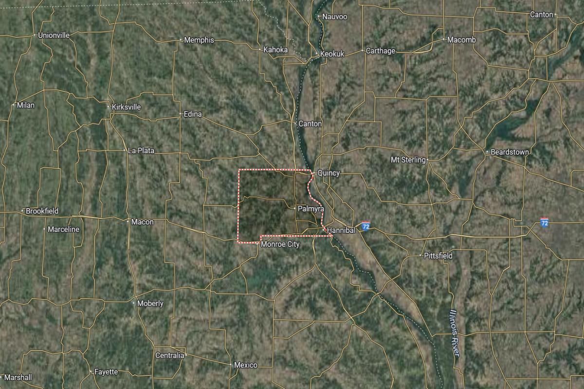
Marion County is located in northeastern Missouri, along the Mississippi River. It lies about 115 miles northwest of St. Louis and approximately 95 miles northeast of Columbia. The county seat, Palmyra, is near US Highways 61 and 24.
The county is roughly 15 miles west of Quincy, Illinois, and about 80 miles southeast of Kirksville. It also sits around 145 miles east of Kansas City. Marion County’s location provides access to river transportation and key highways in northeastern Missouri.
#12. Phelps County, Missouri
– Overall Rank: 418
– Population: 44,843
– Median household income: $53,242
– Median home value: $174,100 (60% own)
– Median rent: $770 (40% rent)
– Top public schools: Mark Twain Elementary School (grade A minus), Wyman Elementary School (grade A minus), Phelps County Elementary School (grade B+)
– Top private schools: St. Patrick School (grade unavailable), Immanuel Lutheran School (grade unavailable), Great Circle – St. James (grade unavailable)
– Top places: Rolla (grade B+), St. James (grade B), Cold Spring Township (grade A minus)
About
Phelps County, Missouri is anchored by a strong educational and engineering presence, which fuels innovation and economic growth. The local economy is a mix of technology, manufacturing, and service industries, supported by research institutions and skilled labor. Community life includes academic events, local festivals, and a focus on lifelong learning.
Natural features like springs, forests, and trails offer residents opportunities for hiking, camping, and outdoor adventure. The county values both progress and preservation, with efforts to maintain its historic character while embracing new development. This blend of knowledge, nature, and tradition defines the area’s unique identity.
Where is Phelps County?
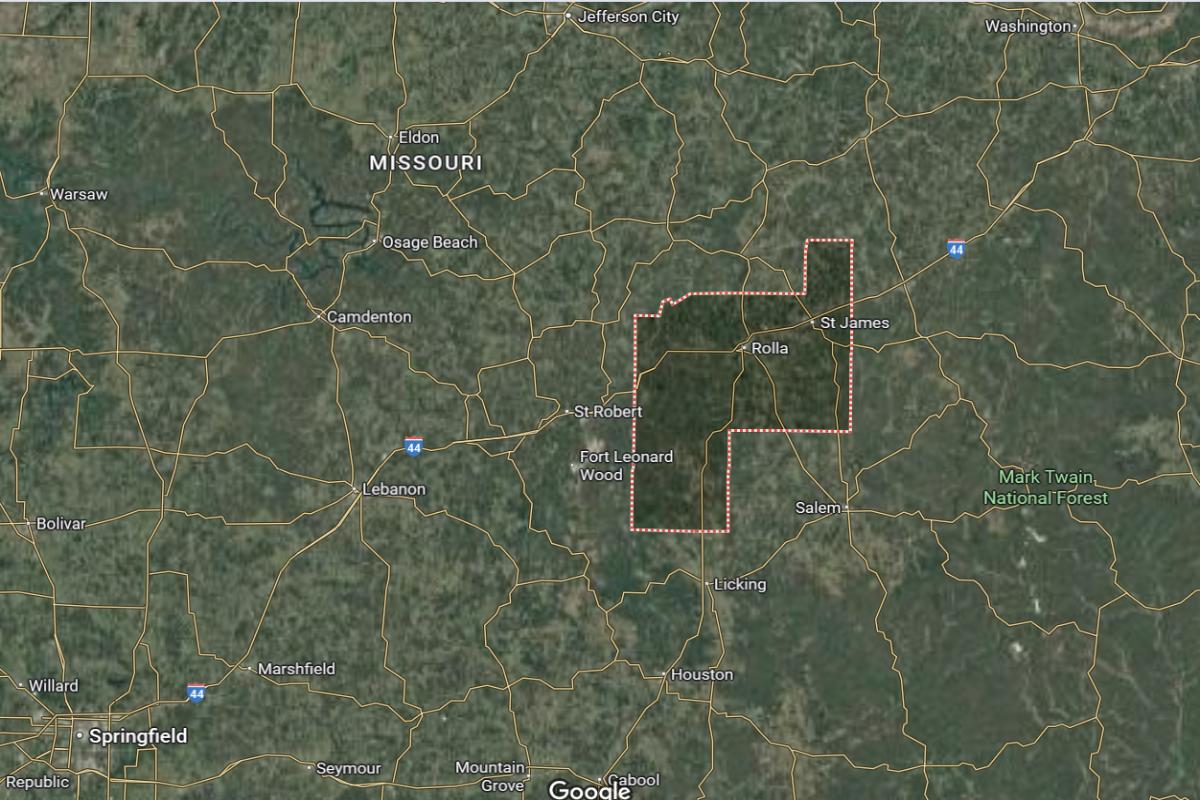
Phelps County is located in south-central Missouri, within the Ozark Highlands region. It lies about 100 miles southwest of St. Louis and approximately 60 miles east of Springfield. The county seat, Rolla, is near I-44 and US Highway 63.
The county is roughly 85 miles south of Jefferson City and about 95 miles northeast of West Plains. It also sits around 140 miles southeast of Columbia. Phelps County’s location offers access to major routes and is a hub for education and research in the region.
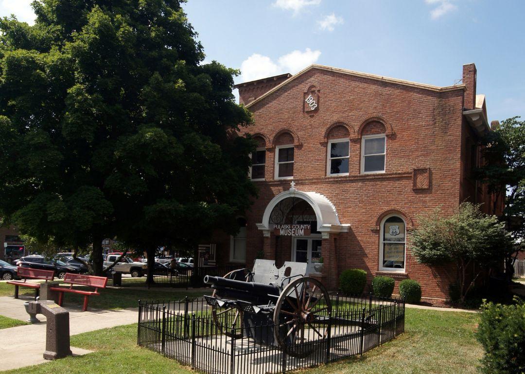
#11. Pulaski County, Missouri
– Overall Rank: 353
– Population: 53,726
– Median household income: $62,541
– Median home value: $177,400 (57% own)
– Median rent: $1,032 (43% rent)
– Top public schools: Thayer Elementary School (grade A), Wood Elementary School (grade A), Waynesville Middle School (grade A minus)
– Top private schools: Maranatha Baptist Academy (grade B+), Westside Christian Academy (grade unavailable), Fort Leonard Wood Child Development Center 408 (grade unavailable)
– Top places: St. Robert (grade B+), Waynesville (grade B), Cullen Township (grade A)
About
Pulaski County, Missouri is deeply influenced by military presence, which plays a major role in its economy and cultural diversity. The area supports a blend of defense-related services, small businesses, and hospitality industries that cater to both residents and visitors. Local life is enriched by patriotic events, community programs, and educational outreach.
The landscape features rivers, caves, and wooded areas ideal for outdoor activities like hiking, fishing, and camping. Historical landmarks and museums highlight the region’s military and pioneer heritage. With its strong civic identity and welcoming atmosphere, the county maintains a balance between service-oriented growth and rural charm.
Where is Pulaski County?
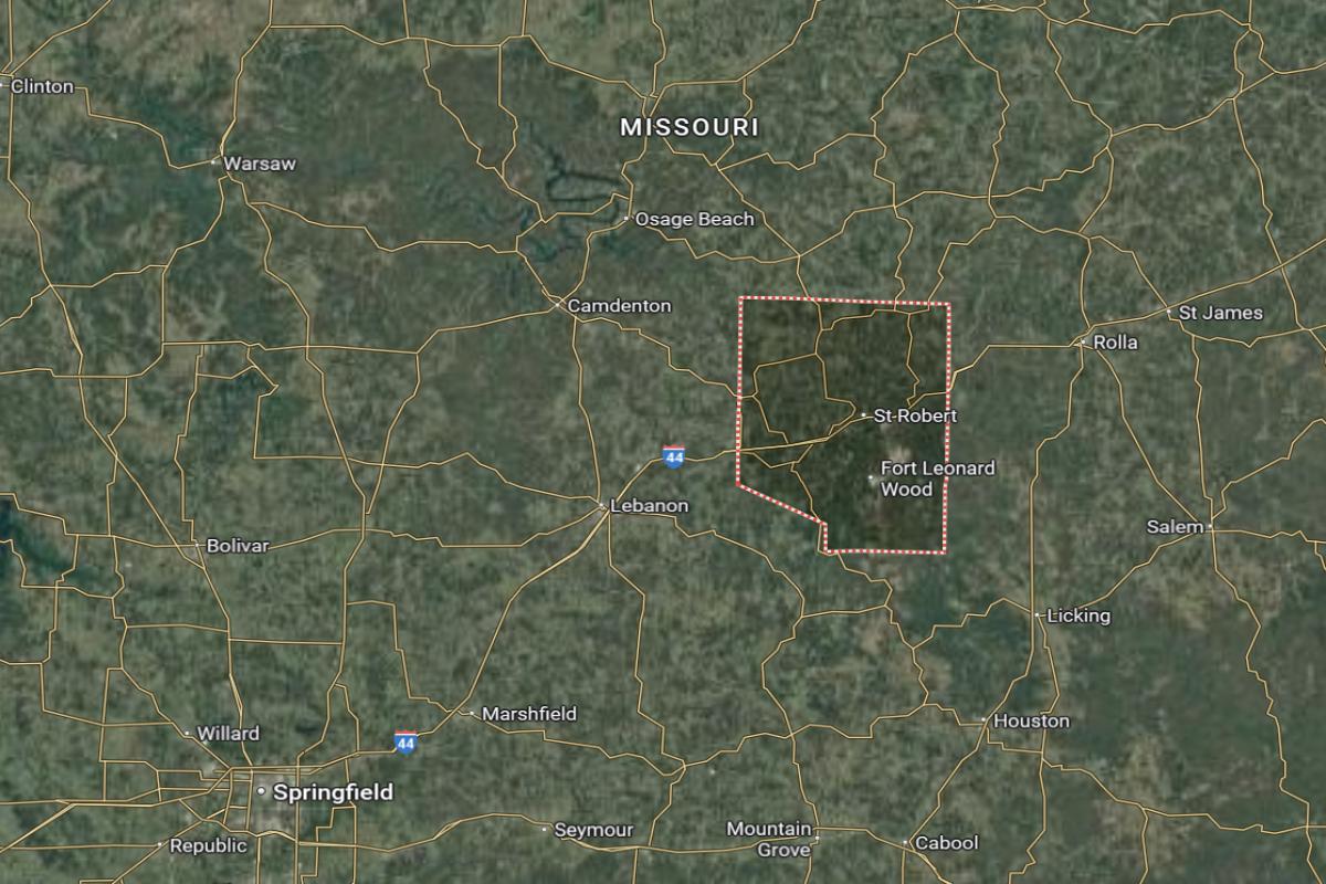
Pulaski County is located in south-central Missouri, within the Ozark Plateau. It lies about 90 miles northeast of Springfield and approximately 130 miles southwest of St. Louis. The county seat, Waynesville, is near I-44 and State Highway 17.
The county is roughly 70 miles south of Columbia and about 80 miles west of Rolla. It also sits around 110 miles southeast of Jefferson City. Pulaski County’s location places it along a major transportation corridor and near several military and recreational areas.
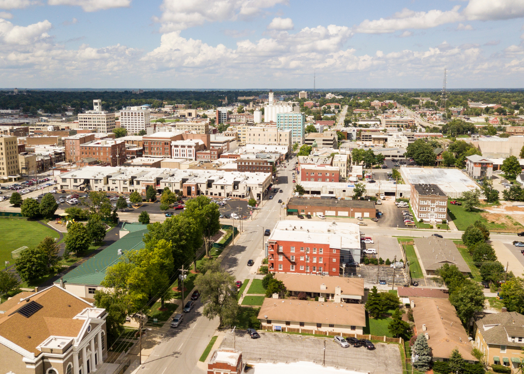
#10. Greene County, Missouri
– Overall Rank: 293
– Population: 299,188
– Median household income: $54,968
– Median home value: $182,800 (57% own)
– Median rent: $895 (43% rent)
– Top public schools: Schofield Elementary School (grade A), Sweeny Elementary School (grade A), Central High School (grade A minus)
– Top private schools: Greenwood Laboratory School (grade A), Springfield Catholic High School (grade A minus), New Covenant Academy (grade B+)
– Top places: Battlefield (grade A), Republic (grade A minus), Willard (grade B+)
About
Greene County, Missouri is a major hub of commerce, education, and healthcare, offering a dynamic blend of urban development and cultural life. Its economy is driven by sectors such as retail, technology, manufacturing, and higher education. The county is known for its vibrant arts scene, diverse neighborhoods, and strong community engagement.
Green spaces, recreational facilities, and public parks provide opportunities for outdoor activities and family gatherings. Historic districts, museums, and annual events reflect the area’s rich heritage and evolving identity. Greene County continues to grow while maintaining a strong sense of place and connection among its residents.
Where is Greene County?
Greene County is located in southwestern Missouri and is a regional hub for business, education, and healthcare. It lies about 110 miles southeast of Kansas City and approximately 220 miles southwest of St. Louis. The county seat, Springfield, is near the intersection of I-44 and US Highway 65.
The county is roughly 85 miles west of Rolla and about 45 miles north of Branson. It also sits around 95 miles northwest of West Plains. Greene County’s location provides strong connectivity to both urban centers and rural parts of southern Missouri.
#9. Christian County, Missouri
– Overall Rank: 290
– Population: 89,568
– Median household income: $75,787
– Median home value: $229,200 (76% own)
– Median rent: $937 (24% rent)
– Top public schools: Mathews Elementary School (grade A), Espy Elementary School (grade A), Nicholas A. Inman Intermediate School (grade A)
– Top private schools: Faith Christian School (grade unavailable)
– Top places: Fremont Hills (grade A), Nixa (grade A), Ozark (grade A minus)
About
Christian County, Missouri combines suburban growth with a strong sense of rural tradition, making it one of the fastest-growing counties in the region. Its economy benefits from residential development, local businesses, and access to larger nearby markets. Community life is centered around schools, churches, and family-oriented events that foster connection and pride.
The county features rolling hills, rivers, and parks that support outdoor activities such as hiking, fishing, and camping. Residents enjoy a balance between quiet, scenic living and modern conveniences. With steady growth and deep community roots, Christian County maintains a welcoming and resilient character.
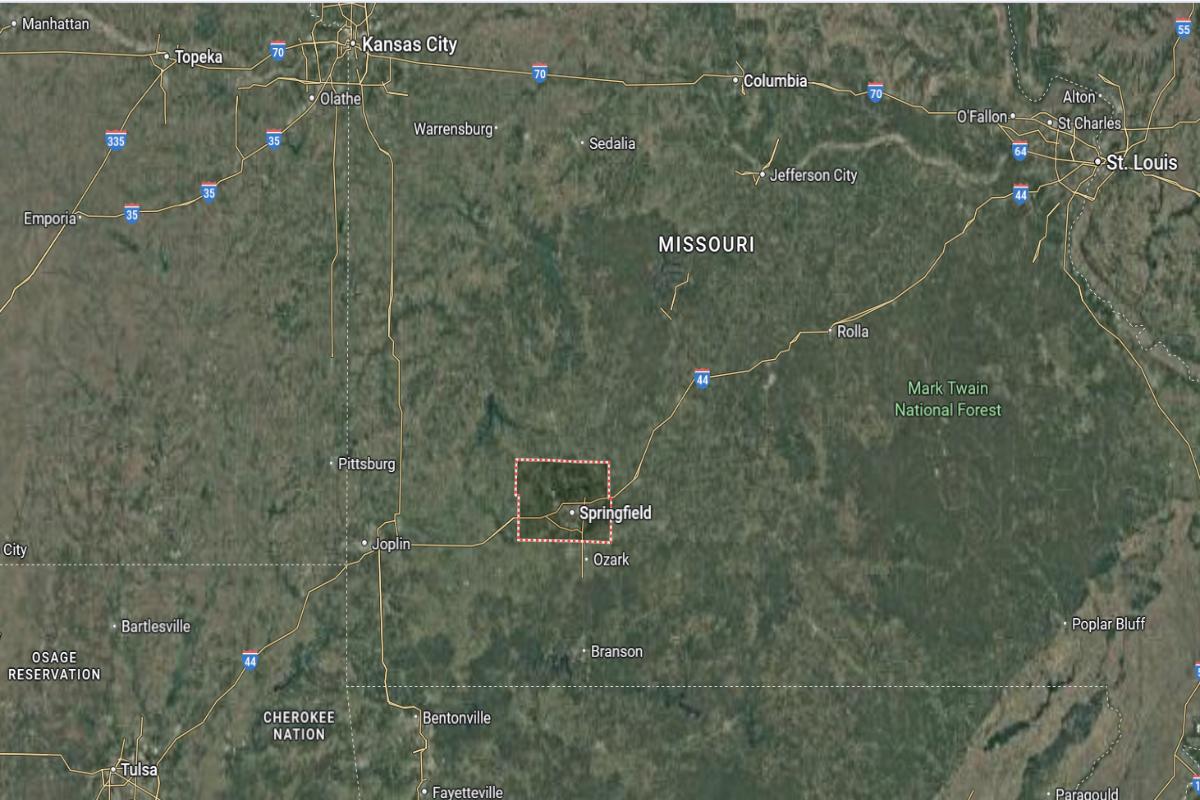
Where is Christian County?
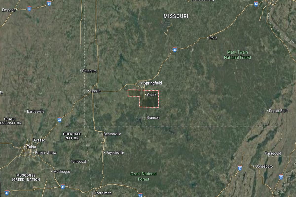
Christian County is located in southwestern Missouri, just south of the city of Springfield. It lies about 30 miles south of Springfield and approximately 150 miles southeast of Kansas City. The county seat, Ozark, is near US Highway 65 and State Highway 14.
The county is roughly 25 miles north of Branson and about 90 miles northeast of Joplin. It also sits around 140 miles southwest of Jefferson City. Christian County’s location places it in a rapidly growing area with close access to major cities and recreational regions.
#8. Jackson County, Missouri
– Overall Rank: 194
– Population: 715,526
– Median household income: $65,169
– Median home value: $196,900 (59% own)
– Median rent: $1,096 (41% rent)
– Top public schools: Delta Woods Middle School (grade A), James Walker Elementary School (grade A), Voy Spears Jr. Elementary School (grade A)
– Top private schools: Pembroke Hill School (grade A+), The Barstow School (grade A+), Notre Dame de Sion High School (grade A+)
– Top places: Lee’s Summit (grade A), Country Club / Waldo (grade A), Midtown / Plaza (grade A)
About
Jackson County, Missouri is a diverse and economically vibrant area with a strong mix of urban, suburban, and industrial development. Its economy is driven by healthcare, government, education, and a wide range of service industries. The county is known for its cultural institutions, sports venues, and active nightlife.
Residents benefit from numerous parks, public spaces, and community programs that support quality of life. Historical landmarks, music heritage, and civic events reflect a rich and evolving identity. With ongoing investment in infrastructure and neighborhoods, Jackson County remains a dynamic and influential part of the region.
Where is Jackson County?
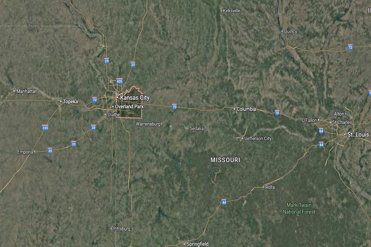
Jackson County is located in western Missouri and includes a major portion of the Kansas City metropolitan area. It lies about 5 miles east of downtown Kansas City and approximately 95 miles west of Columbia. The county seat, Independence, is near I-70 and US Highway 40.
The county is roughly 120 miles northwest of Jefferson City and about 160 miles west of St. Louis. It also sits around 85 miles north of Joplin. Jackson County’s location places it at a central crossroads for commerce, transportation, and urban development in western Missouri.

#7. Clay County, Missouri
– Overall Rank: 177
– Population: 253,085
– Median household income: $82,264
– Median home value: $237,200 (68% own)
– Median rent: $1,133 (32% rent)
– Top public schools: Rising Hill Elementary School (grade A), Franklin Elementary School (grade A), Bell Prairie Elementary School (grade A)
– Top private schools: St. Pius X High School (grade A minus), Eagle Heights Christian School (grade B minus), St. James School (grade unavailable)
– Top places: Liberty (grade A), Shoal Creek Valley (grade A), Gladstone (grade A)
About
Clay County, Missouri offers a mix of suburban living, historical charm, and economic diversity, supported by retail, education, and professional services. The area is known for its strong school systems, community festivals, and vibrant arts scene. Growth in housing and infrastructure reflects its increasing popularity among families and professionals.
Recreational opportunities abound with lakes, trails, and parks that attract outdoor enthusiasts year-round. Museums, landmarks, and local events celebrate the county’s cultural and historical heritage. With a balance of modern development and small-town appeal, Clay County continues to thrive as a connected and welcoming community.
Where is Clay County?
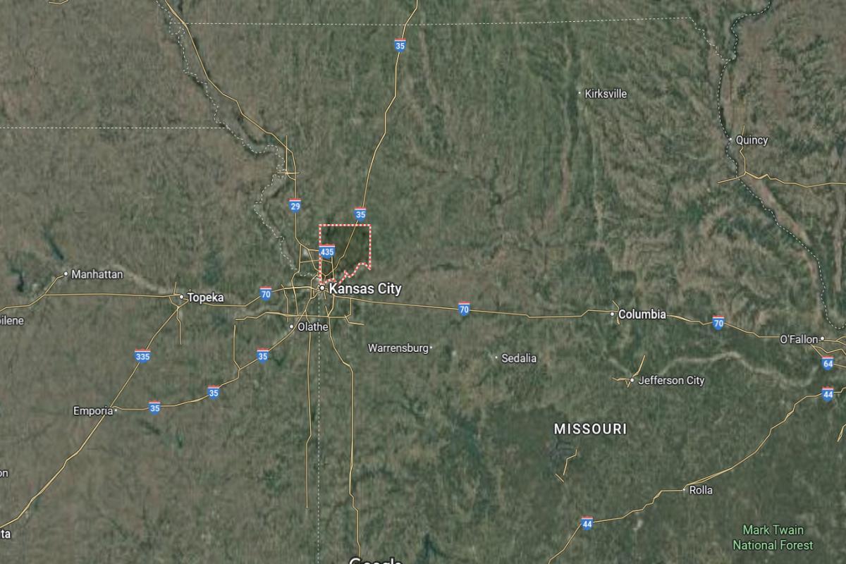
Clay County is located in western Missouri and forms part of the northern Kansas City metropolitan area. It lies about 10 miles north of downtown Kansas City and approximately 100 miles west of Columbia. The county seat, Liberty, is near I-35 and US Highway 69.
The county is roughly 115 miles northwest of Jefferson City and about 150 miles west of St. Louis. It also sits around 95 miles northeast of Joplin. Clay County’s location offers quick access to urban centers, major highways, and regional hubs in western Missouri.
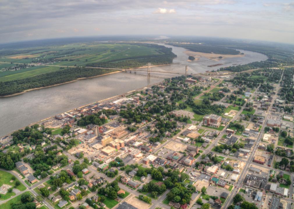
#6. Cape Girardeau County, Missouri
– Overall Rank: 176
– Population: 81,703
– Median household income: $65,070
– Median home value: $194,200 (67% own)
– Median rent: $854 (33% rent)
– Top public schools: West Lane Elementary School (grade A minus), Jackson Senior High School (grade A minus), Russell Hawkins Junior High School (grade B+)
– Top private schools: Notre Dame Regional High School (grade A minus), Saxony Lutheran High School (grade B), Eagle Ridge Christian School (grade B)
– Top places: Jackson (grade A minus), Cape Girardeau (grade B+), Cape Girardeau Township (grade A minus)
About
Cape Girardeau County, Missouri is a regional center for education, healthcare, and commerce, blending historical significance with modern growth. Its economy thrives on a mix of medical services, retail, manufacturing, and university-related activity. The community supports a lively arts and cultural scene alongside strong civic involvement.
Natural beauty surrounds the area with riverfront views, parks, and conservation areas offering space for recreation and relaxation. Historic districts, museums, and annual events highlight the county’s deep roots and vibrant present. With a commitment to progress and preservation, Cape Girardeau County fosters both tradition and innovation.
Where is Cape Girardeau County?
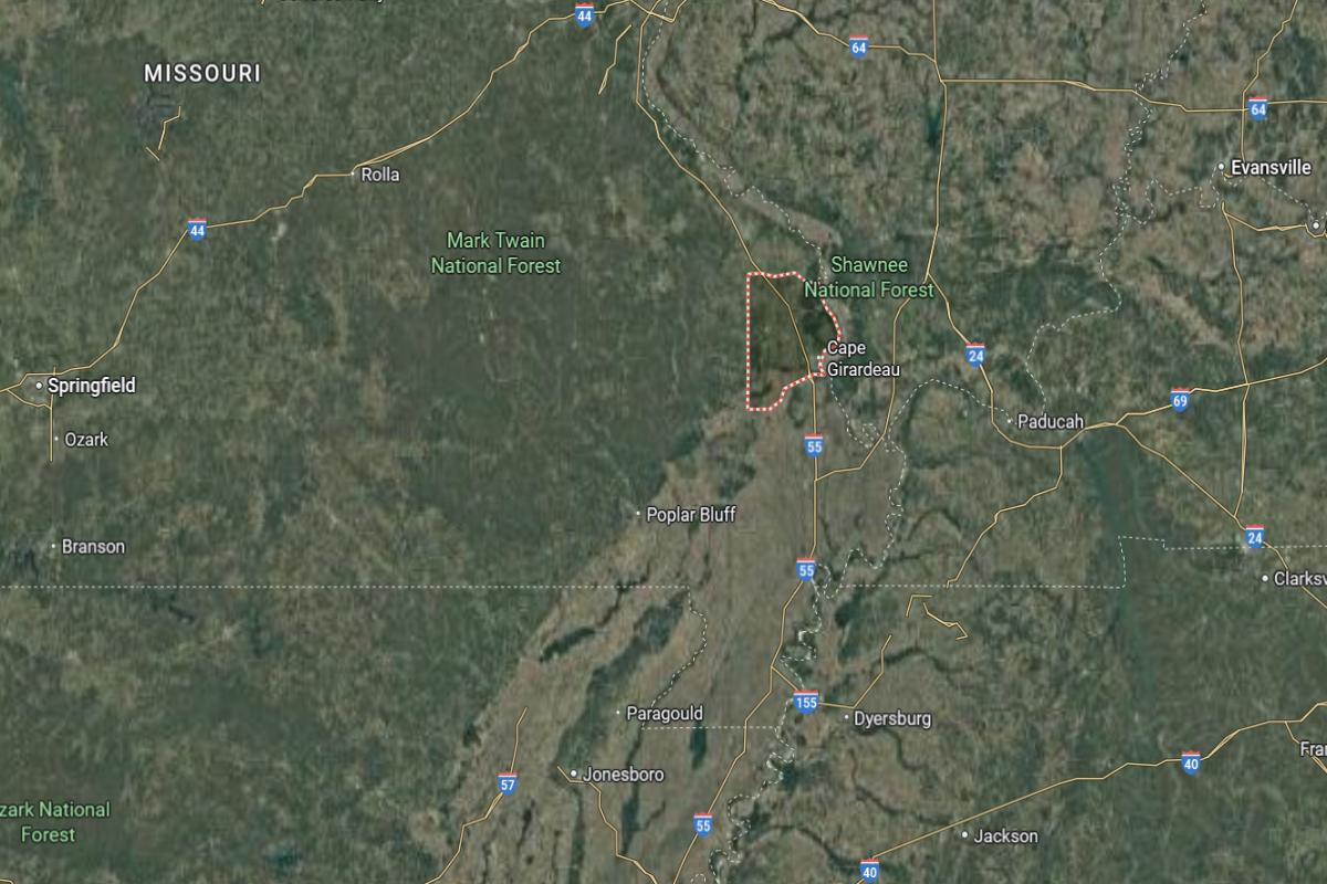
Cape Girardeau County is located in southeastern Missouri along the Mississippi River. It lies about 115 miles south of St. Louis and approximately 55 miles northeast of Poplar Bluff. The county seat, Jackson, is near I-55 and US Highway 61.
The county is roughly 35 miles northwest of the Missouri–Kentucky border and about 90 miles east of Farmington. It also sits around 165 miles southeast of Jefferson City. Cape Girardeau County’s location provides strong river access and regional connectivity across southeastern Missouri.
#5. Cole County, Missouri
– Overall Rank: 110
– Population: 76,890
– Median household income: $70,667
– Median home value: $198,900 (67% own)
– Median rent: $783 (33% rent)
– Top public schools: Blair Oaks Elementary School (grade A), Blair Oaks Middle School (grade A), Capital City High School (grade B+)
– Top private schools: Lighthouse Preparatory Academy (grade B+), Helias Catholic High School (grade B+), Calvary Lutheran High School (grade C+)
– Top places: Jefferson City (grade A minus), St. Martins (grade B+), Jefferson Township (grade A)
About
Cole County, Missouri serves as a hub for government, law, and administration, supporting a steady economy with public sector employment and legal services. The county also benefits from healthcare, education, and small business development that contribute to its stable foundation. Community activities, local markets, and historic charm shape daily life for residents.
Parks, greenways, and recreational facilities provide ample space for outdoor enjoyment and family gatherings. Landmarks, preserved architecture, and public events reflect the county’s deep historical and political heritage. With its blend of tradition, public service, and civic pride, Cole County maintains a strong and connected identity.
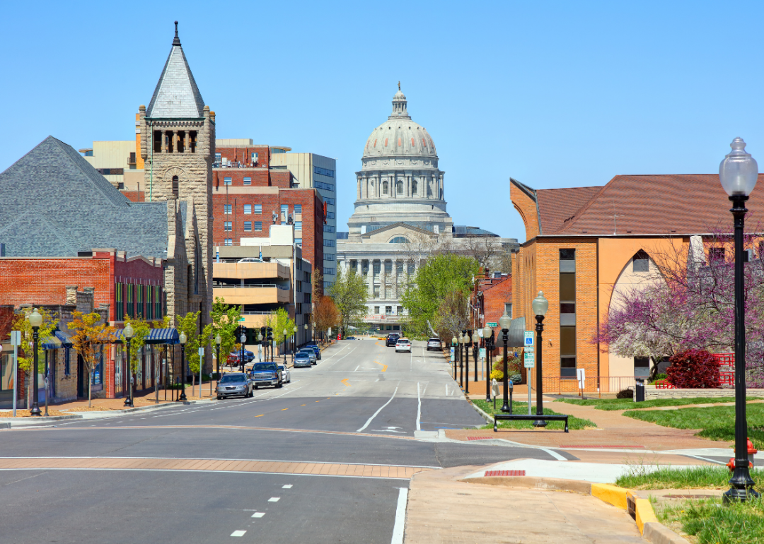
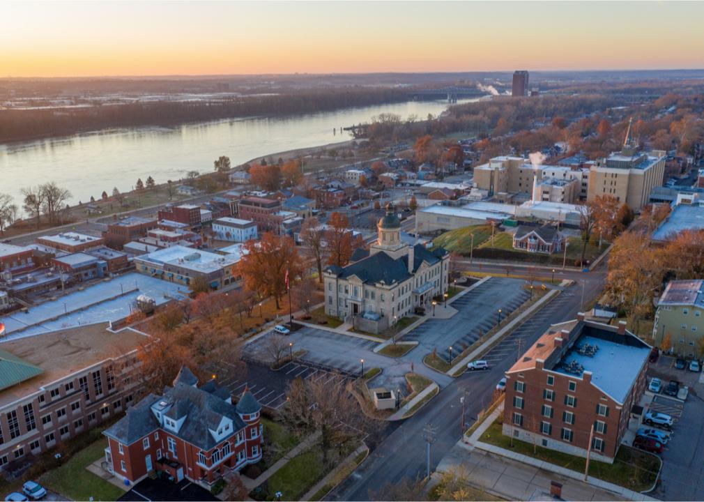
Where is Cole County?
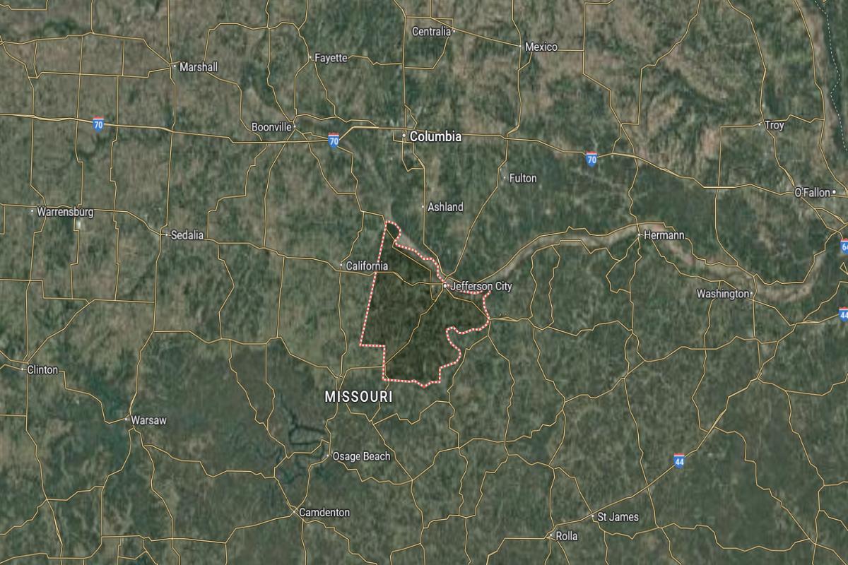
Cole County is located in central Missouri and is home to the state capital. It lies about 30 miles south of Columbia and approximately 125 miles west of St. Louis. The county seat, Jefferson City, is near US Highways 54 and 63.
The county is roughly 90 miles southeast of Kansas City and about 70 miles north of Rolla. It also sits around 100 miles northeast of Springfield. Cole County’s location provides central access to major cities and government institutions in Missouri.

#4. Platte County, Missouri
– Overall Rank: 70
– Population: 107,033
– Median household income: $92,543
– Median home value: $288,100 (66% own)
– Median rent: $1,210 (34% rent)
– Top public schools: Park Hill South High School (grade A), Graden Elementary School (grade A), English Landing Elementary School (grade A)
– Top private schools: Faith Christian Academy (grade A minus), Northland Christian Schools (grade B minus), St. Therese School (grade A)
– Top places: Parkville (grade A+), Weatherby Lake (grade A+), Lake Waukomis (grade A)
About
Platte County, Missouri is a fast-growing area known for its blend of suburban development, business growth, and strong infrastructure. The local economy benefits from transportation networks, retail centers, and professional services that support a high quality of life. Community amenities, good schools, and civic engagement contribute to its widespread appeal.
The county features parks, trails, and recreational facilities that promote outdoor activity and family living. Historical sites and cultural programs add depth to its modern growth and development. With a balance of natural beauty and expanding opportunity, Platte County continues to attract residents and businesses alike.
Where is Platte County?
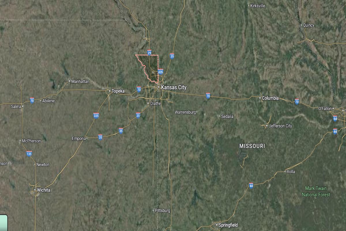
Platte County is located in northwestern Missouri and forms part of the Kansas City metropolitan area. It lies about 10 miles northwest of downtown Kansas City and approximately 110 miles west of Columbia. The county seat, Platte City, is near I-29 and State Highway 92.
The county is roughly 25 miles south of St. Joseph and about 120 miles northwest of Jefferson City. It also sits around 140 miles north of Joplin. Platte County’s location provides key access to metropolitan routes, regional airports, and nearby state borders.
#3. St. Charles County, Missouri
– Overall Rank: 62
– Population: 406,262
– Median household income: $99,596
– Median home value: $278,300 (81% own)
– Median rent: $1,209 (19% rent)
– Top public schools: Fort Zumwalt West Middle School (grade A), Twin Chimneys Elementary School (grade A), Fort Zumwalt South Middle School (grade A)
– Top private schools: Duchesne High School (grade A minus), St. Dominic High School (grade A minus), Lutheran High School of St. Charles County (grade B+)
– Top places: Cottleville (grade A), Dardenne Prairie (grade A), O’Fallon (grade A)
About
St. Charles County, Missouri is one of the fastest-growing regions in the state, known for its strong economy, suburban development, and family-friendly communities. It thrives on a mix of manufacturing, healthcare, retail, and technology industries that fuel continued expansion. Schools, community events, and modern infrastructure support a high standard of living.
The county offers scenic riverfronts, parks, and trails that encourage outdoor recreation and tourism. Historic downtowns, festivals, and cultural attractions celebrate both heritage and progress. With its combination of growth, livability, and rich local character, St. Charles County remains a vibrant and desirable place to live and work.
Where is St. Charles County?
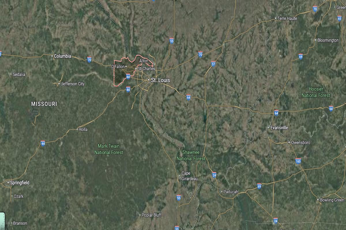
St. Charles County is located in eastern Missouri, just west of the Mississippi River. It lies about 30 miles northwest of St. Louis and approximately 110 miles east of Columbia. The county seat, St. Charles, is near I-70 and State Highway 94.
The county is roughly 135 miles northeast of Jefferson City and about 90 miles southeast of Hannibal. It also sits around 170 miles east of Kansas City. St. Charles County’s location offers immediate access to major urban areas and transportation corridors in eastern Missouri.

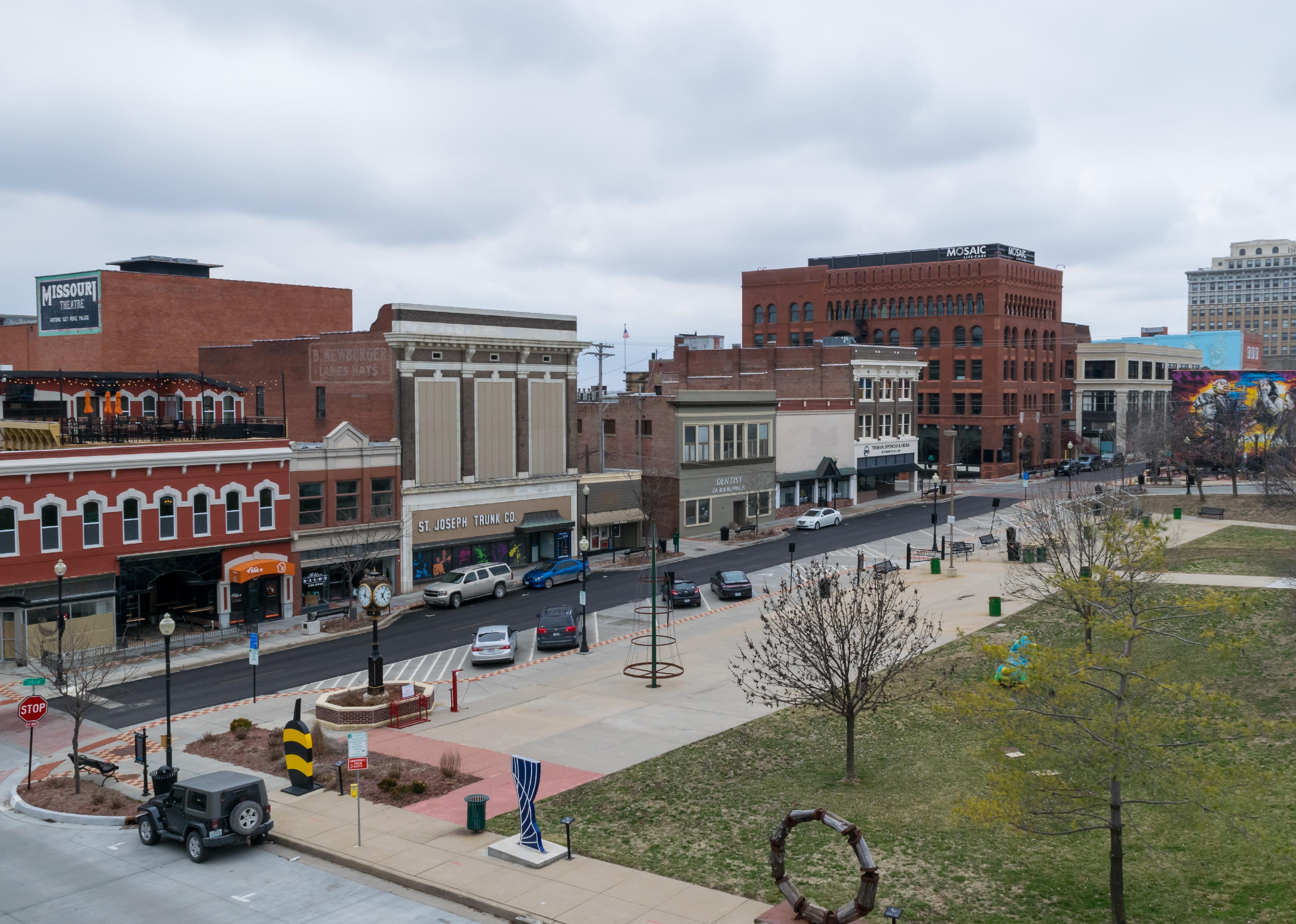
#2. Boone County, Missouri
– Overall Rank: 21
– Population: 184,043
– Median household income: $66,564
– Median home value: $237,600 (58% own)
– Median rent: $994 (42% rent)
– Top public schools: Rock Bridge High School (grade A), John Warner Middle School (grade A), Mill Creek Elementary School (grade A minus)
– Top private schools: Columbia Independent School (grade A+), Christian Fellowship School (grade A), Heritage Academy (grade B+)
– Top places: Columbia (grade A), Ashland (grade B+), Centralia (grade B+)
About
Boone County, Missouri is a vibrant center for education, innovation, and healthcare, anchored by a major university and research institutions. The economy is fueled by technology, public services, retail, and a dynamic student population. Community life is enriched by cultural events, academic activity, and strong civic involvement.
The county features an extensive network of parks, trails, and green spaces that support outdoor lifestyles and environmental stewardship. Historic neighborhoods, local markets, and public festivals showcase the area’s diverse character and welcoming spirit. With a blend of progress, tradition, and community focus, Boone County continues to thrive as a hub of opportunity and culture.
Where is Boone County?
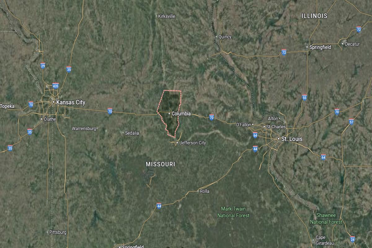
Boone County is located in central Missouri and is home to the University of Missouri. It lies about 30 miles north of Jefferson City and approximately 120 miles west of St. Louis. The county seat, Columbia, is near I-70 and US Highway 63.
The county is roughly 90 miles east of Kansas City and about 75 miles north of Rolla. It also sits around 160 miles southeast of St. Joseph. Boone County’s location provides central access to major cities, education centers, and transportation routes in Missouri.
#1. St. Louis County, Missouri
– Overall Rank: 20
– Population: 999,703
– Median household income: $78,067
– Median home value: $249,400 (68% own)
– Median rent: $1,119 (32% rent)
– Top public schools: Ladue Horton Watkins High School (grade A+), Clayton High School (grade A+), Wydown Middle School (grade A+)
– Top private schools: John Burroughs School (grade A+), MICDS – Mary Institute & St. Louis Country Day School (grade A+), Thomas Jefferson School (grade A+)
– Top places: Brentwood (grade A+), Chesterfield (grade A+), Clayton (grade A+)
About
St. Louis County, Missouri is a major economic and cultural center, offering a diverse blend of industries, neighborhoods, and institutions. The economy thrives on sectors like healthcare, finance, education, and technology, supported by a strong network of businesses and public services. Communities across the county reflect a mix of urban vitality, suburban comfort, and historic charm.
Parks, museums, and cultural venues provide residents with abundant recreational and artistic opportunities. The county hosts numerous events, festivals, and public programs that celebrate its rich heritage and community diversity. With its extensive infrastructure and dynamic population, St. Louis County remains a key hub of innovation, culture, and everyday life.
Where is St. Louis County?
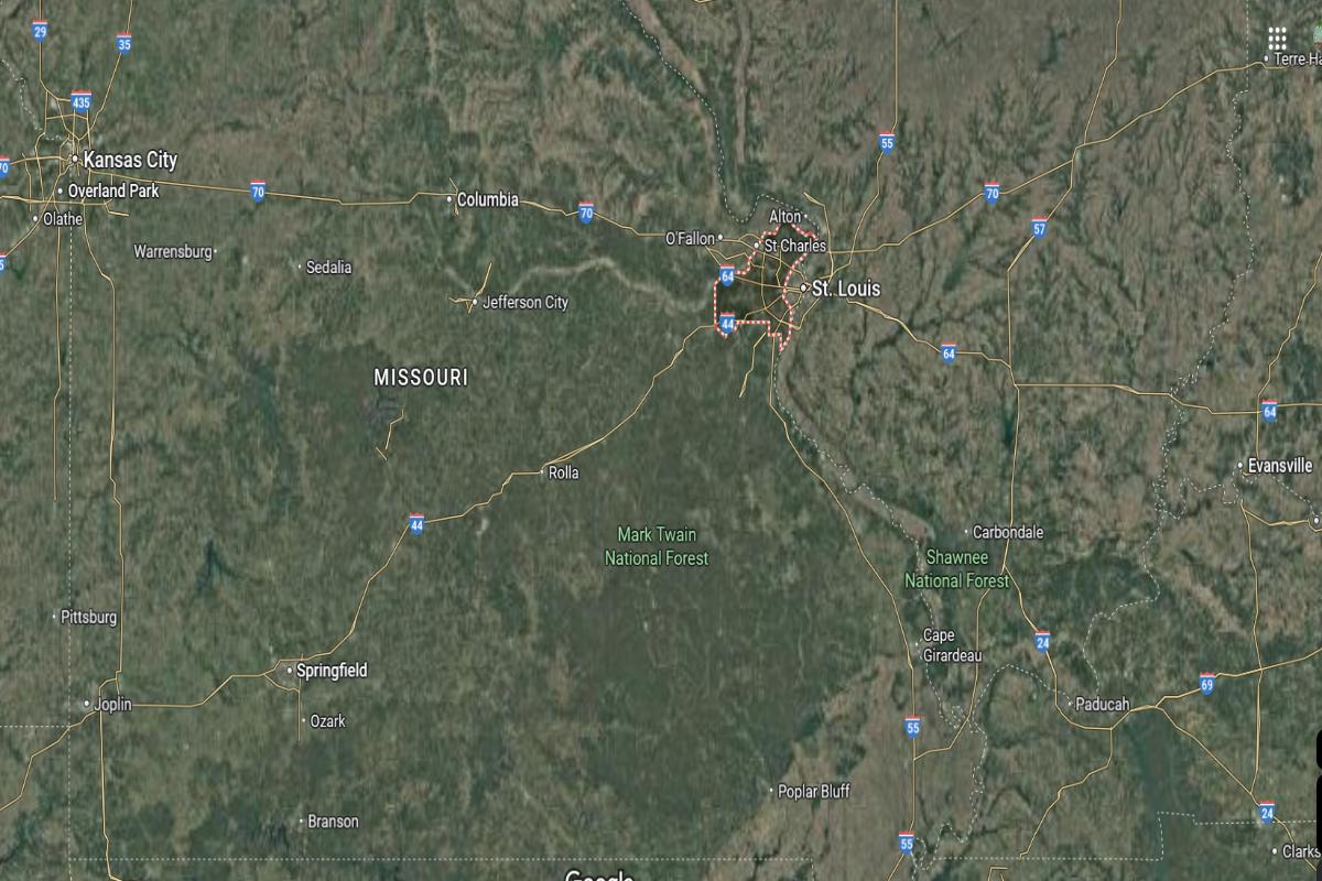
St. Louis County is located in eastern Missouri and surrounds the independent city of St. Louis. It lies directly west of downtown St. Louis and approximately 115 miles east of Columbia. The county seat, Clayton, is near I-64 and I-170.
The county is roughly 130 miles northeast of Jefferson City and about 250 miles east of Kansas City. It also sits around 95 miles southeast of Hannibal. St. Louis County’s location places it at a key junction for commerce, transportation, and metropolitan life in eastern Missouri.
This story features data reporting and writing by Elena Cox and is part of a series utilizing data automation across 50 states.
By Stacker