🔥 Would you like to save this?
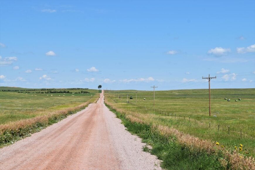
Southern North Dakota still has places where the prairie swallows every sound and the sky feels twice as wide. Our team picked 25 towns that reward travelers and potential residents with room to breathe, plenty of character, and the quiet that only distance can provide.
Grain elevators, century-old churches, and mirror-still pothole lakes set the scene, yet each community adds its own surprise: murals on a side street, a lone baseball diamond, or a rebuilt homestead after a grass fire.
In order to come up with the very specific design ideas, we create most designs with the assistance of state-of-the-art AI interior design software.
Populations dip as low as sixteen, traffic counts barely register, and the nearest four-lane road can sit dozens of miles away. Camera buffs, stargazers, and anyone eager for an unhurried pace will find more than enough inspiration.
The countdown starts on the open plains west of the Missouri River and winds east toward the South Dakota line.
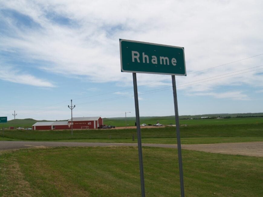
25. Rhame – Gateway to the Western Edge
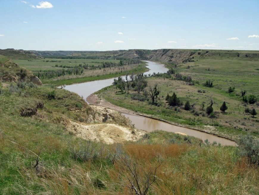
Rhame sits quietly on the rolling prairie of southwestern North Dakota, far from bustling highways and framed by open grasslands that stretch toward the horizon. The town’s few streets hold a tight-knit community where life is guided by ranching, farming, and the rhythm of the seasons.
Its wide skies and soft winds give it a feeling of endless space, with silence broken only by the call of meadowlarks or the lowing of cattle. Visitors can explore the nearby Little Missouri National Grassland, hunt or fish in the surrounding countryside, or follow backroads that wind through buttes and hidden valleys.
Summer brings golden waves of wheat, and winter lays a quiet blanket of snow across the land. Evenings here settle into a calm that feels unshaken by time. It’s the kind of place where the horizon becomes your companion.
Where is Rhame?
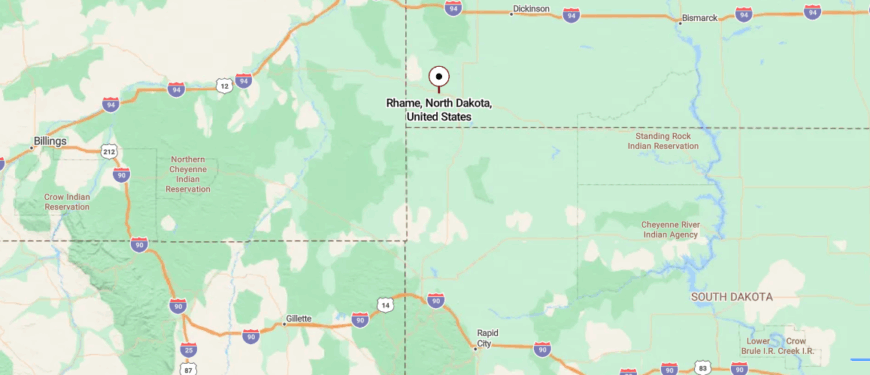
Rhame is located in southwestern North Dakota, about 11 miles east of the Montana border along U.S. Highway 12. Set amid rolling prairie and open sky, it lies far from major population centers, giving it a quiet, spacious feel.
The highway approach stretches across wide grasslands with distant buttes breaking the horizon before reaching the small town. It’s close enough to connect with nearby communities, yet it feels surrounded by a horizon that goes on forever.
24. Amidon – County Seat in Miniature

Amidon rests at the edge of the Little Missouri National Grassland, surrounded by rolling hills and open prairie that keep it far removed from the pace of larger towns. With only a handful of streets and a close-knit community, it’s one of the smallest county seats in the nation, where life revolves around ranching, farming, and the steady cycles of the land.
The air is wide and still, carrying the scent of grass in summer and woodsmoke in winter. Visitors can explore the scenic backroads leading into the grasslands, hike among nearby buttes, or watch wildlife in the quiet valleys.
In spring, wildflowers scatter across the hills, and in autumn, the prairie glows under golden light. Nights are clear and vast, with stars stretching endlessly overhead. It’s the kind of place where the silence feels as expansive as the sky.
Where is Amidon?
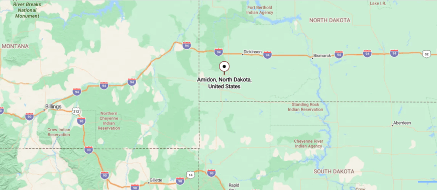
Amidon sits in southwestern North Dakota, about 32 miles north of Bowman along State Route 85. Surrounded by open prairie and the rugged buttes of the Little Missouri National Grassland, it’s well removed from major highways and larger towns.
The road in rolls gently across wide, treeless expanses, with sweeping views in every direction. It’s near enough for a short trip from neighboring communities, yet it feels anchored in its own quiet stretch of the plains.
23. Regent – End of the Enchanted Highway
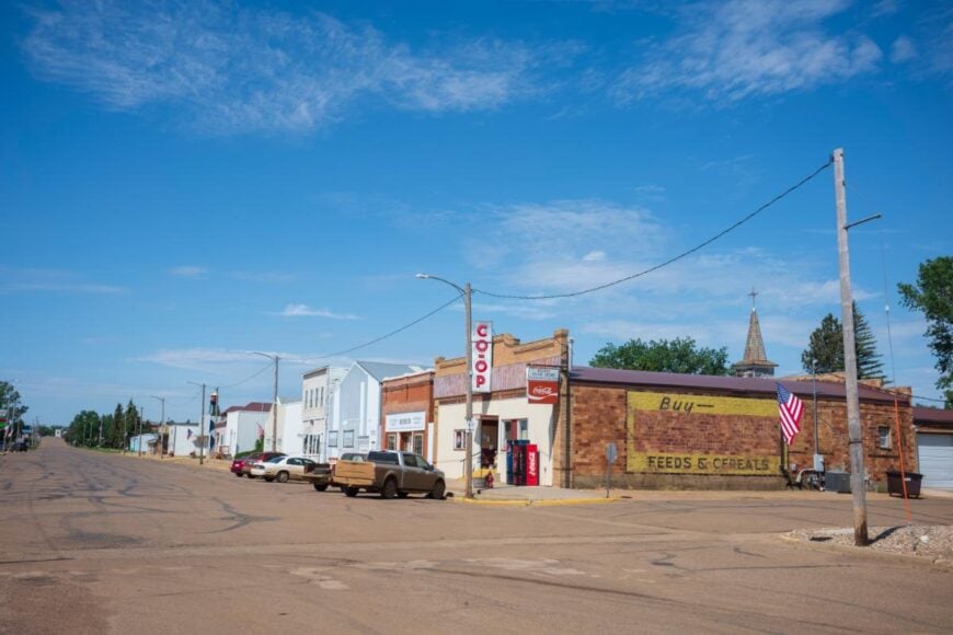
Regent lies along a quiet stretch of Highway 21 in southwestern North Dakota, surrounded by vast prairie and distant buttes that keep it far from crowded places. The town is best known as the starting point of the Enchanted Highway, where towering metal sculptures rise from the fields.
Life here is shaped by farming, ranching, and the steady rhythm of rural living. Visitors can follow the Enchanted Highway to see its unique art installations, explore nearby hunting and fishing spots, or simply enjoy the endless views from the backroads.
Summer brings green fields and the hum of warm winds, while winter covers the prairie in crisp, white quiet. Evenings settle into stillness under a sky crowded with stars. It’s the kind of place where the land feels as endless as your thoughts.
Where is Regent?
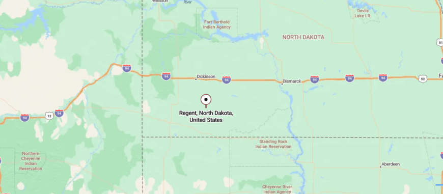
Regent lies in southwestern North Dakota, about 26 miles south of I-94 at Gladstone along State Route 21. Surrounded by rolling prairie and farmland, it sits away from major traffic routes, giving it a calm, unhurried pace.
The approach follows a two-lane road that winds past fields and open grasslands before entering the small community. It’s close enough for a day’s drive from larger cities, yet it feels like a place where the wide horizon still sets the rhythm.
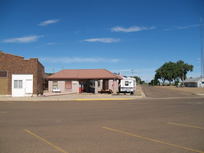
22. Mott – Prairie River Bend
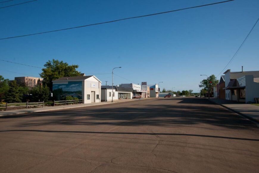
Mott sits along the Cannonball River in the heart of the prairie, its quiet streets surrounded by wide fields and rolling hills that stretch for miles. The town carries the steady rhythm of farming and ranching, with a close-knit community rooted in the land.
Here, the breeze moves easily across the grass, carrying the scent of crops in summer and the sharp chill of snow in winter. Visitors can fish or paddle along the Cannonball River, explore local parks, or take scenic drives through the surrounding countryside.
Spring brings fresh green to the hills, and autumn paints the fields in gold. Nights are calm and open, with stars shining clear above the horizon. It’s the kind of place where the quiet settles deep and stays.
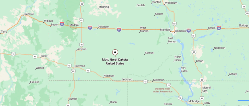
Where is Mott?
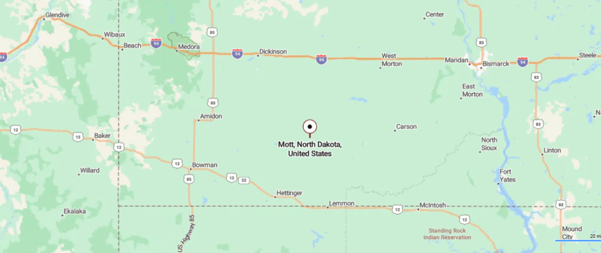
Mott is located in southwestern North Dakota, about 25 miles west of Regent along State Route 21. Framed by open prairie and the Cannonball River, it sits well off the interstate, lending it a slower, more local pace.
The drive in follows gentle curves through farmland and rolling grasslands before reaching the town center. It’s within reach of regional hubs, yet it feels rooted in the quiet expanse of the plains.
21. Hettinger – Quiet Hub of the Southwest
Hettinger rests near the border with South Dakota, surrounded by open prairie and gently rolling hills that keep it well apart from the busier parts of the state. The town serves as a hub for the surrounding ranching and farming communities, with life moving at the steady pace of the land.
Wide streets and friendly storefronts give it a welcoming, unhurried feel. Visitors can explore nearby Mirror Lake Park, follow scenic drives into the prairie, or enjoy local events that bring neighbors together.
In spring, the grasslands turn a fresh, vibrant green, while autumn lays a warm, golden hue over the fields. Winter nights are crisp and still, with stars spread endlessly overhead. It’s the kind of place where the horizon feels both near and boundless.
Where is Hettinger?
Hettinger sits in the far southwestern corner of North Dakota, about 9 miles east of the South Dakota border along U.S. Highway 12. Surrounded by wide prairie and low, rolling hills, it lies far from the state’s larger cities, giving it an open, spacious feel.
The highway approach stretches straight through farmland and open range before reaching the small but active community. It’s close enough to connect with neighboring states, yet it feels firmly grounded in its own quiet corner of the plains.
20. Scranton – Grain Town on the High Plains
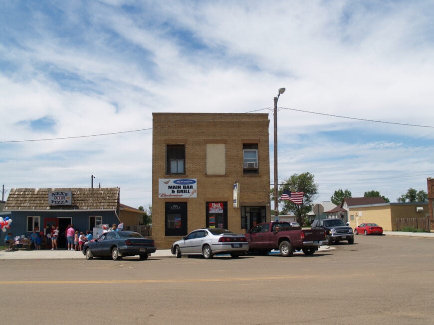
Scranton rests along Highway 12 in the gently rolling prairie of southwestern North Dakota, far from the rush of larger cities. Its quiet neighborhoods and small business district reflect a community closely tied to farming, ranching, and the steady rhythms of rural life.
The air carries the scent of cut hay in summer and woodsmoke in the colder months. Visitors can explore nearby hunting grounds, take scenic drives through the open countryside, or visit local parks for a peaceful afternoon.
Spring brings new life to the fields, and autumn drapes the land in warm, golden tones. Evenings are calm, with wide skies giving way to a blanket of stars. It’s the kind of place where the days feel unhurried, and the land feels endless.
Where is Scranton?
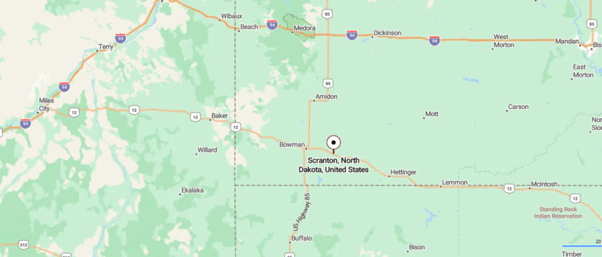
Scranton is located in southwestern North Dakota, about 13 miles north of Bowman along U.S. Highway 85. Set amid open prairie and gentle hills, it sits away from major interstates, giving it a calm, small-town pace.
The approach follows a straight stretch of highway bordered by farmland and wide horizons before reaching the community. It’s near enough to larger towns for convenience, yet it feels like a place where time moves a little slower.
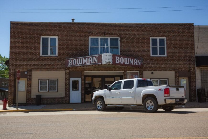
19. Bowman – Wide Streets, Sparse Crowds
🔥 Would you like to save this?
Bowman sits in the rolling prairie of southwestern North Dakota, serving as a gateway to both wide-open grasslands and the rugged beauty of nearby buttes. The town hums with the work of farming, ranching, and local businesses that anchor the community.
Main Street offers a mix of shops, cafes, and gathering spots where neighbors linger to talk. Visitors can explore Pioneer Trails Regional Museum, fish or picnic at nearby Bowman-Haley Lake, or follow backroads into the scenic Little Missouri National Grassland.
Summer brings long, warm days over green fields, and autumn paints the prairie in shades of gold. Nights are open and still, the stars stretching across an endless sky. It’s the kind of place where the land feels as much a part of you as the people do.
Where is Bowman?
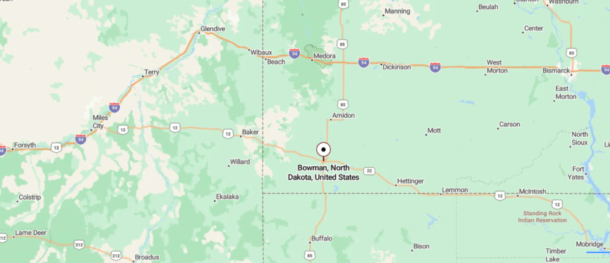
Bowman lies in southwestern North Dakota, about 27 miles north of the South Dakota border along U.S. Highway 85. Surrounded by open prairie and distant buttes, it sits far from the state’s urban centers, lending it a wide-open, frontier feel.
The highway in runs past grazing land and rolling fields before reaching the town’s main streets. It’s close enough to serve as a regional hub, yet it still carries the quiet rhythm of the surrounding plains.
18. New Leipzig – Porches Over the Prairie
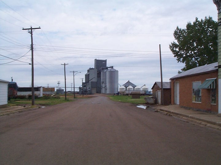
New Leipzig rests in the open prairie of southwestern North Dakota, its quiet streets lined with modest homes and a few long-standing businesses that serve the close-knit community. Surrounded by farmland and gentle rolling hills, it feels far removed from the rush of bigger towns.
Life here is rooted in agriculture, with seasons marked by planting, harvest, and the steady rhythm of rural living. Visitors can attend local festivals, explore small-town landmarks, or drive the scenic backroads that stretch toward the horizon.
In summer, fields ripple with green and gold, while winter lays a soft hush over the land. Evenings bring skies lit with stars in every direction. It’s the kind of place where the stillness feels complete.
Where is New Leipzig?
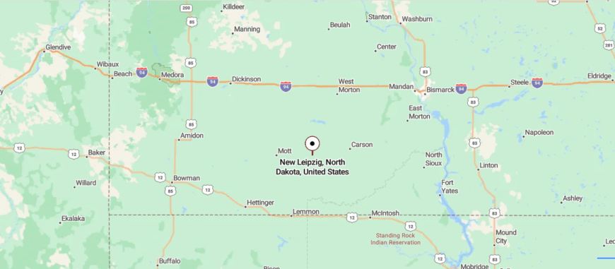
New Leipzig is located in south-central North Dakota, about 17 miles south of I-94 at Glen Ullin along State Route 49. Surrounded by farmland and rolling prairie, it sits well away from major population centers, giving it a peaceful, rural feel.
The approach follows a two-lane road through open fields and gentle hills before arriving in the small community. It’s close enough to reach from the interstate, yet it feels like a quiet stop far from the main flow of traffic.
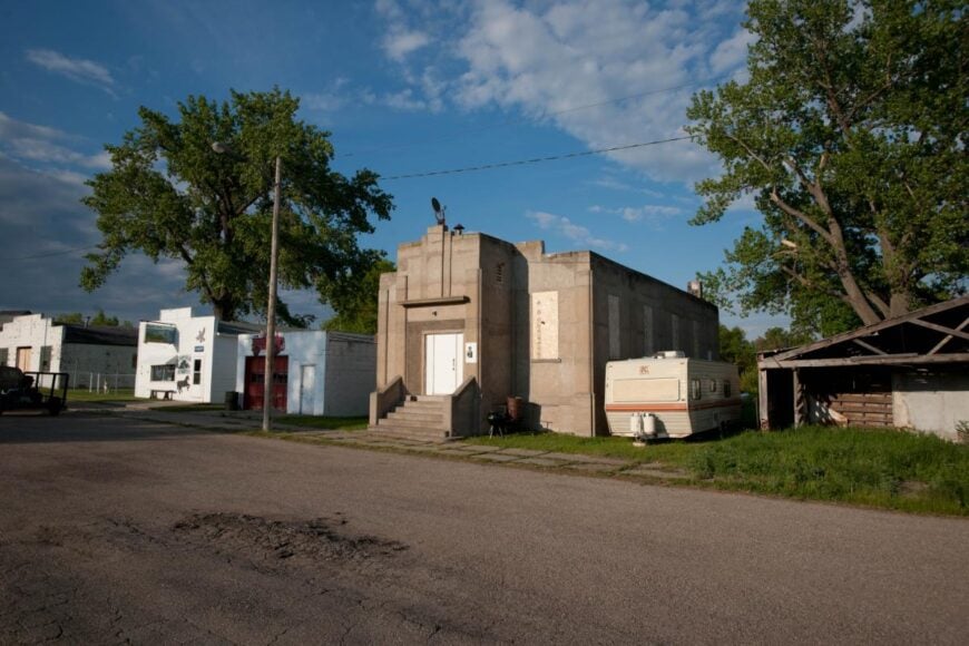
17. Elgin – Market Town of the West Prairie
Elgin sits along Highway 49 in the heart of farm and ranch country, surrounded by wide prairie and softly rolling hills that stretch for miles. The town’s pace is steady, shaped by agriculture and the close ties of a community that knows its neighbors well.
Here, the wind moves easily across open fields, carrying the scent of grain in summer and the crisp bite of snow in winter. Visitors can enjoy local parks, attend seasonal fairs, or take scenic drives through the surrounding countryside.
Spring brings fresh green to the land, and autumn bathes it in warm, golden light. Nights are quiet beneath a sky bright with stars. It’s the kind of place where the horizon feels like part of home.
Where is Elgin?
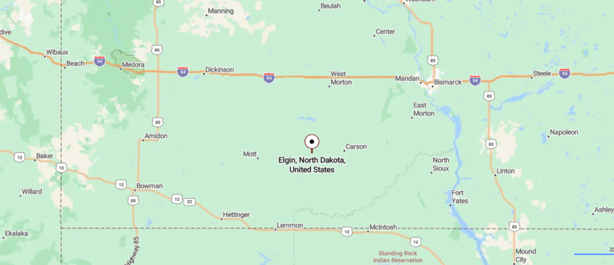
Elgin sits in south-central North Dakota, about 20 miles south of I-94 at Glen Ullin along State Route 49. Surrounded by gently rolling farmland and open prairie, it lies far from the state’s larger cities, giving it a calm, rural character.
The road in passes through wide fields and scattered farmsteads before reaching the town center. It’s close enough to connect with nearby communities, yet it feels settled into its own steady rhythm.
16. Venturia – Hamlet at the End of the Road
Venturia rests in the gently rolling farmland of south-central North Dakota, tucked away on quiet roads far from larger towns. Its small cluster of homes and outbuildings is surrounded by fields that shift with the seasons, from fresh green in spring to golden waves at harvest.
Life here revolves around agriculture, with neighbors lending a hand when the work calls for it. Visitors can follow backroads through the countryside, watch wildlife in the open fields, or simply take in the calm of the wide horizon.
Summer days bring the hum of tractors and warm breezes, while winter covers the land in still, white quiet. Evenings are marked by the glow of farm lights under a spread of stars. It’s the kind of place where the quiet feels deep and lasting.
Where is Venturia?
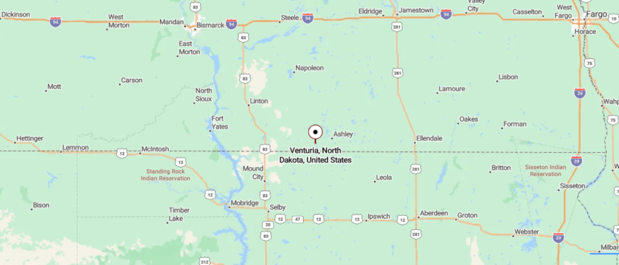
Venturia is located in south-central North Dakota, about 9 miles north of the South Dakota border along State Route 3. Surrounded by farmland and open prairie, it sits well off the main highways, adding to its quiet, out-of-the-way feel.
The approach follows a straight, two-lane road through wide fields before the small community comes into view. It’s near enough to reach from larger towns, yet it feels like a place where the horizon is the dominant feature.
15. Lehr – Where Two Counties Meet
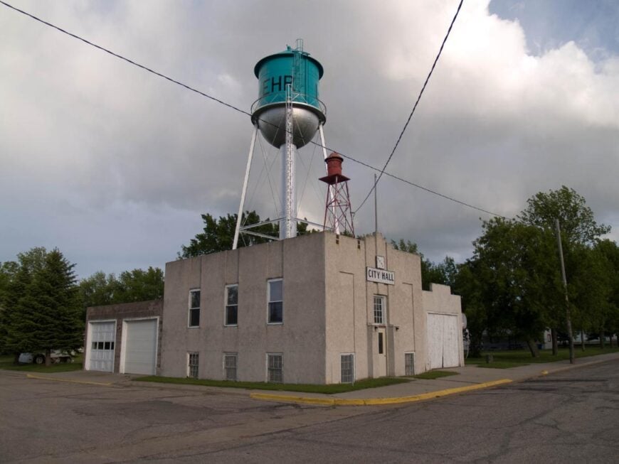
Lehr rests in the rolling farmland of south-central North Dakota, surrounded by open fields and prairie that stretch far in every direction. The town’s quiet streets and close-knit community reflect a life centered on agriculture, with each season shaping the pace of the days.
Here, the sound of wind through the grass and the call of meadowlarks often replace the noise of traffic. Visitors can explore nearby fishing spots, take scenic drives along rural backroads, or enjoy local gatherings that bring neighbors together.
Summer brings green fields and long, warm evenings, while winter lays a calm blanket of snow over the land. Nights are peaceful, with stars shining clear in the wide prairie sky. It’s the kind of place where time slows and the silence feels complete.
Where is Lehr?
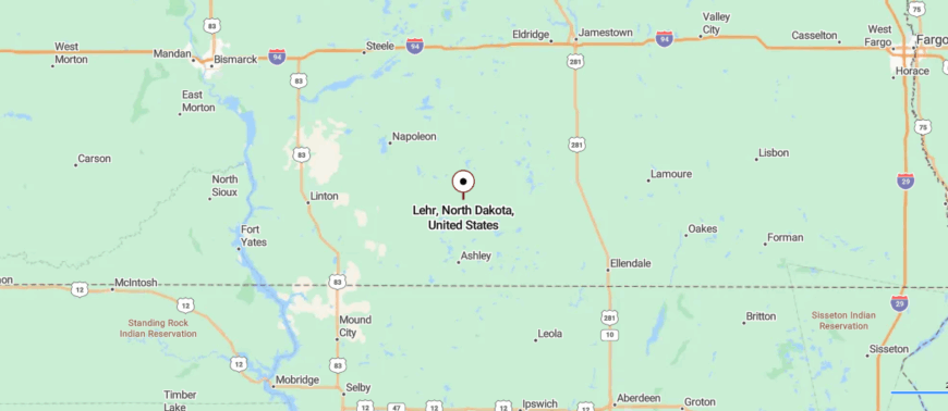
Lehr lies in south-central North Dakota, about 20 miles southeast of Napoleon along State Route 34. Surrounded by open farmland and gentle prairie hills, it sits away from major highways, giving it a quiet, close-knit atmosphere.
The drive in follows a two-lane road bordered by fields and windbreaks before arriving in the small community. It’s close enough to connect with nearby towns, yet it feels set apart in its own unhurried space.
14. Gackle – Prairie Town with a Birding Reputation
Gackle rests in the prairie country of south-central North Dakota, surrounded by farmland that stretches toward the horizon in every direction. The town’s small grid of streets holds a close-knit community where farming and ranching guide the rhythm of life.
Here, the breeze carries the scent of crops in summer and the crisp chill of snow in winter. Visitors can fish or birdwatch at nearby Gackle Wildlife Management Area, follow quiet country roads for scenic drives, or stop in at local cafes that serve as gathering spots.
Spring brings fresh green to the fields, and autumn turns them to gold under wide skies. Evenings settle into stillness broken only by the sounds of the land. It’s the kind of place where the open space feels endless.
Where is Gackle?
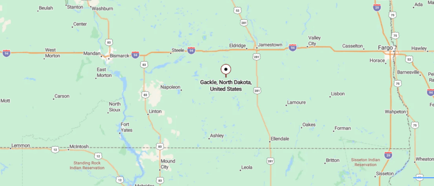
Gackle is located in south-central North Dakota, about 25 miles south of Jamestown along State Route 56. Surrounded by farmland and prairie lakes, it sits well off the interstate, giving it a peaceful, rural setting.
The approach follows a two-lane road that rolls gently through open fields and wetlands before reaching the town. It’s close enough for an easy drive from larger communities, yet it feels firmly rooted in the quiet of the prairie.
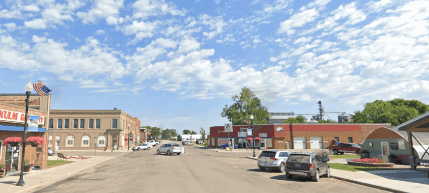
13. Kulm – Quiet by the Lake
🔥 Would you like to save this?
Kulm sits in the rolling farmland of south-central North Dakota, where open fields and quiet roads keep it far from the rush of city life. The town’s steady pace is shaped by agriculture, with neighbors gathering for local events and lending a hand when the work is heavy.
The air carries the scent of freshly cut hay in summer and woodsmoke in winter. Visitors can explore nearby lakes for fishing and boating, take scenic drives through the prairie, or enjoy small-town festivals that celebrate the season.
Spring paints the land in soft greens, while autumn lays it in gold beneath wide skies. Nights are calm, with stars stretching clear from horizon to horizon. It’s the kind of place where the stillness stays with you.
Where is Kulm?
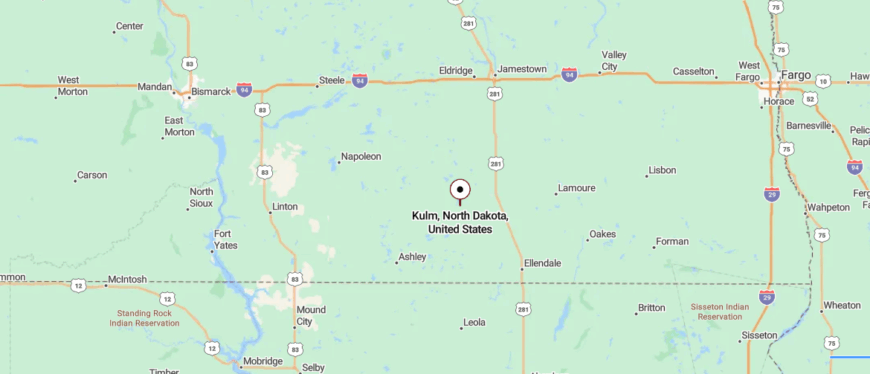
Kulm sits in south-central North Dakota, about 28 miles south of Jamestown along State Route 56. Framed by farmland and open prairie, it lies far from major highways, giving it a slower, small-town pace.
The drive in passes wide fields, grain elevators, and gentle hills before reaching the community. It’s near enough to connect with neighboring towns, yet it feels anchored in its own quiet stretch of the plains.
12. Ashley – County Seat with a Slow Pulse
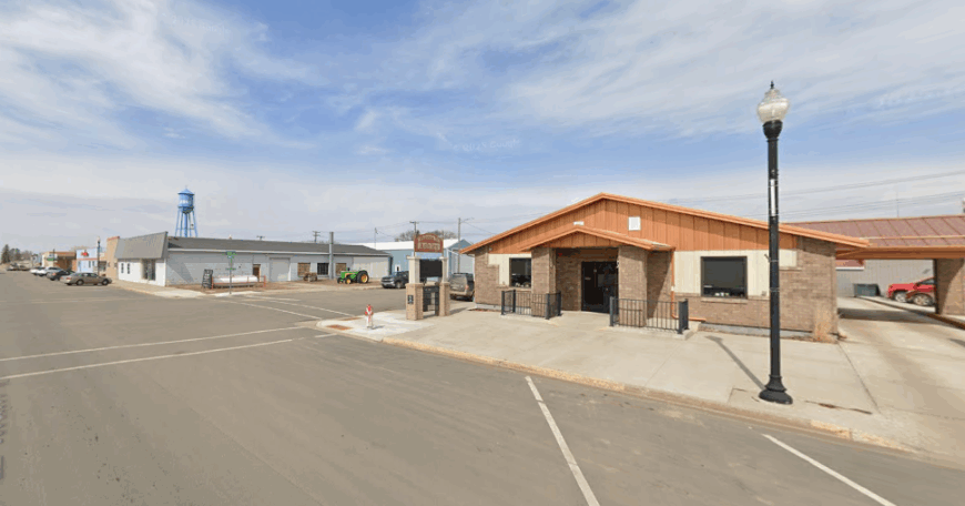
Ashley rests in the gentle prairie of south-central North Dakota, surrounded by farmland and small lakes that give it both space and seclusion. The town’s wide streets and well-worn storefronts reflect a community rooted in agriculture, where the pace follows planting, harvest, and the turning of the seasons.
Here, the breeze carries the scent of grain in summer and the crisp bite of winter air. Visitors can fish or paddle on nearby Lake Hoskins, explore local parks, or take scenic drives through the surrounding countryside.
Spring brings soft greens to the fields, and autumn glows with golden light. Evenings are quiet, with stars spread wide across the open sky. It’s the kind of place where the land feels as much a home as the town itself.
Where is Ashley?
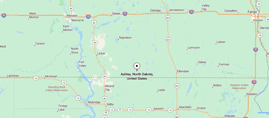
Ashley is located in south-central North Dakota, about 10 miles north of the South Dakota border along U.S. Highway 281. Surrounded by rolling farmland and prairie lakes, it sits far from larger cities, giving it a calm, rural character.
The approach follows a straight highway through open fields and shelterbelts before arriving in the community. It’s close enough to reach from regional hubs, yet it feels like a place where life moves at its own steady pace.
11. Wishek – Sauerkraut Capital with Space to Spare
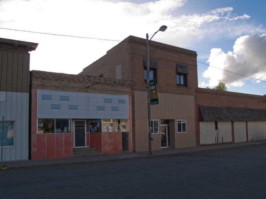
Wishek sits amid miles of open prairie, its streets lined with a mix of long-standing businesses, tidy homes, and gathering spots that reflect a deep sense of community. Farming and ranching form the backbone of life here, with each season bringing its own rhythm—planting in spring, harvest in fall, and quiet reflection in winter.
Visitors might spend the day at Green Lake, wander through local shops, or time their trip for the famed Sauerkraut Day, when the whole town comes alive. In summer, warm breezes move through endless fields, and in winter, a calm hush settles over the land.
The sunsets stretch in bold colors across the horizon, and nights reveal a sky bright with stars. It’s the kind of place where open space feels like a welcome companion.
Where is Wishek?
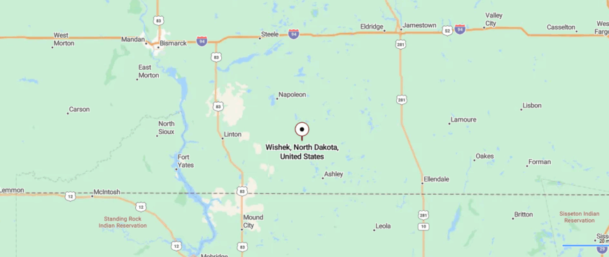
Wishek sits in south-central North Dakota, about 20 miles north of Ashley along State Route 3. Surrounded by farmland and gently rolling prairie, it lies well away from major interstates, giving it a quiet, rural pace.
The drive in follows open stretches of road lined with fields and windbreaks before reaching the small town. It’s close enough to connect with neighboring communities, yet it feels grounded in its own steady rhythm.
10. Leith – An Almost-Ghost Prairie Settlement
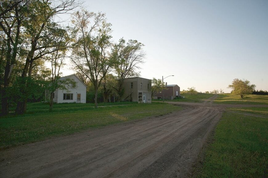
Leith lists roughly 16 residents, making it one of the smallest incorporated places in the state. Visitors often spend a morning photographing empty grain elevators, leaning wooden sheds, and pioneer gravestones in the windswept cemetery.
A few ranching operations and seasonal wheat harvest crews supply the only regular commerce, while the remaining households rely on cattle, custom haying, or remote work. Weekend explorers appreciate the absence of city glare for astrophotography and the wide prairie dog towns that dot the edges of Main Street.
Seclusion comes from sheer distance: no services for miles, patchy cell reception, and a single gravel spur leading into town. The stillness turns every creak of a screen door or call of a meadowlark into an event.
Where is Leith?
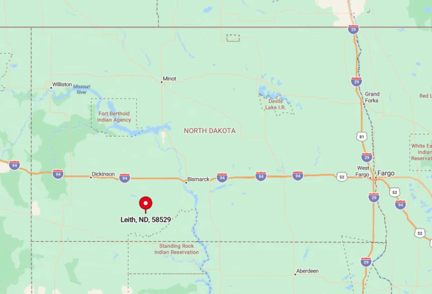
Leith sits in Grant County, roughly 80 miles southwest of Bismarck and about 20 miles off U.S. Highway 21. Low rolling hills and shelterbelt groves block sightlines to any sizable settlement, adding to the tucked-away feeling.
Reaching town requires turning west at Carson, then following a gravel ribbon that sees more farm trucks than cars. Those willing to make the drive are rewarded with uninterrupted horizons and some of the darkest night skies in the region.
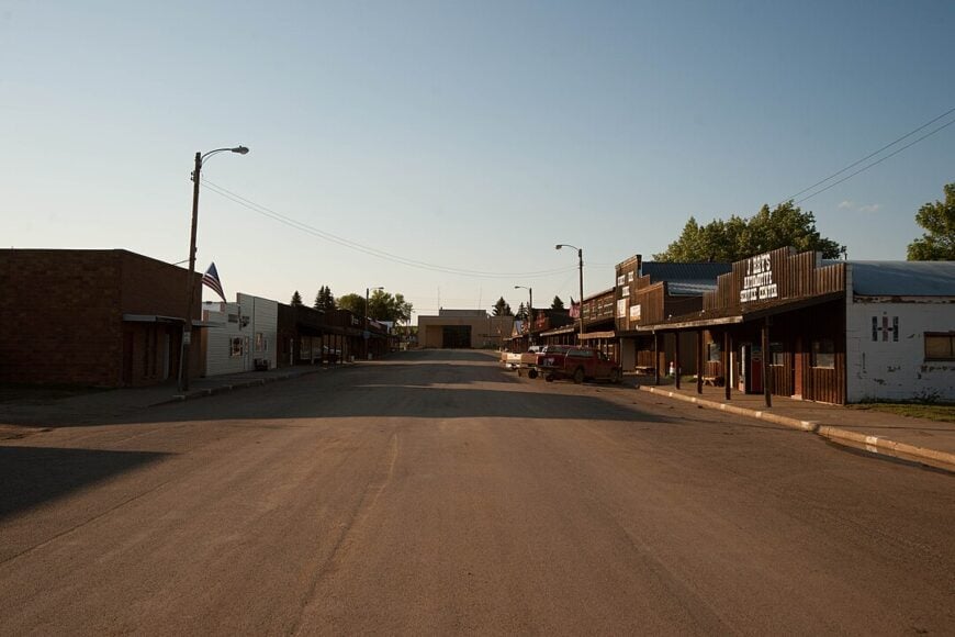
9. Braddock – One Street, Endless Sky
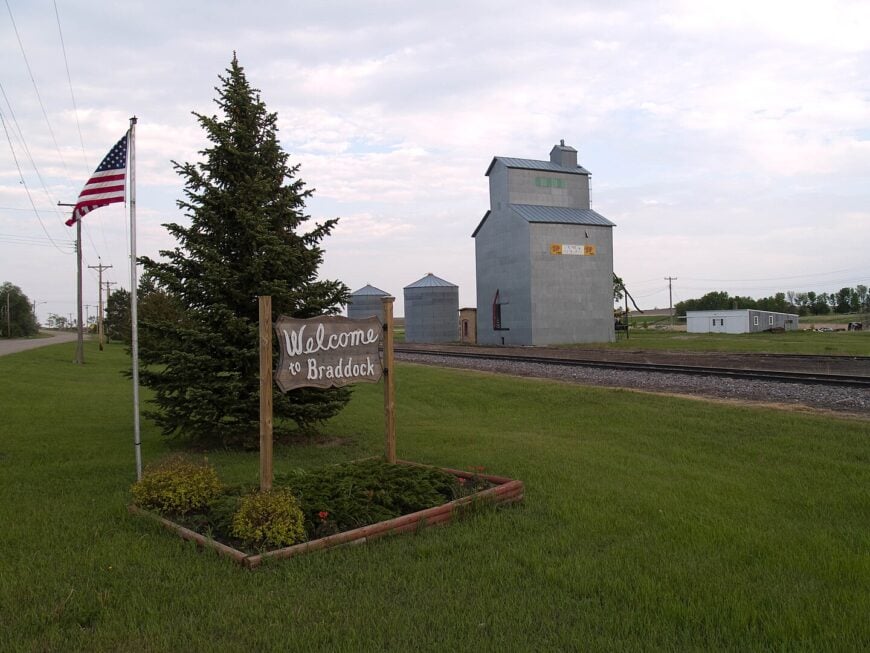
About 20 people call Braddock home, and the entire business strip fits on a single paved block framed by a century-old Lutheran steeple. Bird-watchers pause at nearby wetlands that host migrating sandhill cranes, while locals hold occasional potluck dinners in the former school gym.
Wheat and soybean farming provide the town’s economic backbone, supplemented by custom combining outfits during harvest. Stargazing after sunset reveals an ink-black canopy, thanks to minimal street lighting and flat glacial hills that block distant glow.
The town’s isolation is emphasized by near-silent nights broken only by the whistle of a grain train that passes once or twice a week. Photographers value the near-perfect 360-degree horizons for dramatic storm-cloud captures.
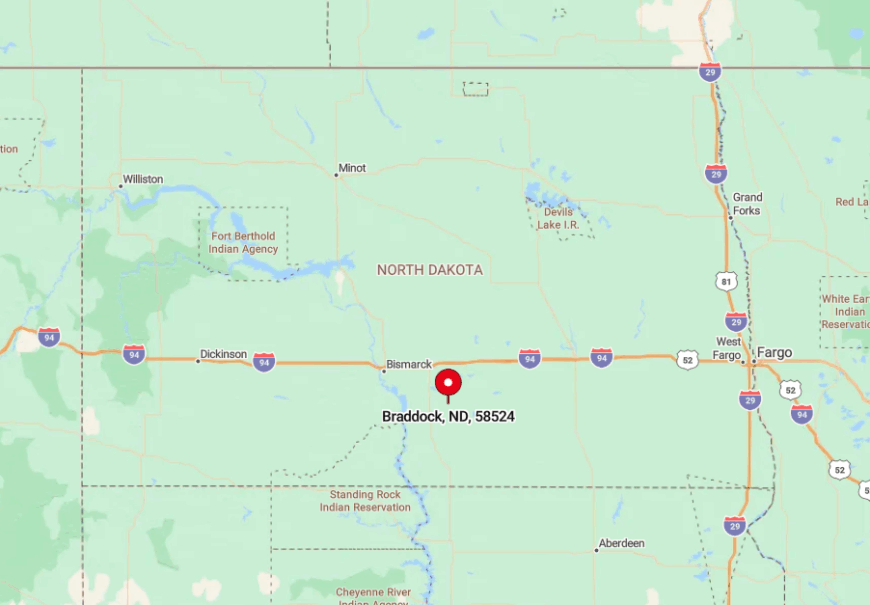
Where is Braddock?
🔥 Would you like to save this?
Braddock lies 40 minutes south of Interstate 94 and 60 miles southeast of Bismarck in Emmons County. The nearest gas pump is 18 miles away in Linton, underscoring how rarely traffic visits.
County Road 83 serves as the main access route, turning to gravel just outside the town limits. Travelers often meet a single pickup on the drive in, then none at all on the way out.
8. Carson – Hidden in Grant County’s Rolling Coulees
Carson supports close to 280 residents who enjoy wide lawns, shaded by mature elms, and a small downtown anchored by a family grocery that doubles as a café. Hikers trek the wooded ravines north of town and hunt for agates in nearby coulees after spring rains.
Agriculture rules the local economy, with wheat, sunflowers, and cattle grazing on the surrounding hills, while the Grant County courthouse adds a trickle of government jobs. Seclusion stems from geography: protective hills muffle highway sounds and discourage through-traffic.
Even on fair-weather Fridays, the post office parking lot rarely hosts more than three vehicles. Residents claim that a barking dog can be heard clean across town on still mornings.
Where is Carson?
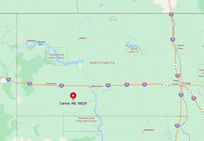
Carson rests 15 miles south of North Dakota Highway 21 and nearly 90 miles from the closest commercial airport in Bismarck. The rolling prairie hides it from the nearest four-lane highway, making the settlement nearly invisible until the last mile.
Access comes via State Route 49 followed by a short jog west on County Road 12. Those extra turns filter out casual passersby, preserving the town’s quiet character.
7. Selfridge – Quiet Along the Standing Rock Bluffs
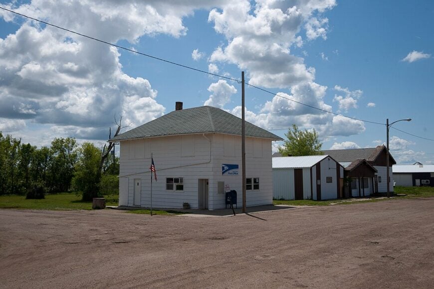
Selfridge, population around 160, lines its main avenue with painted murals portraying Lakota and pioneer history. Anglers drift along the Missouri River backwaters just five miles west, while cyclists pedal the lightly traveled county blacktops that roll toward the South Dakota border.
School, ranching, and small-scale grain operations supply most paychecks, with occasional art commissions tied to the mural project. Cottonwoods and boxelder trees form natural sound barriers, and the absence of chain stores ensures nights remain hushed.
Visitors often remark on the layered silence broken only by distant coyotes. A mix of cultural heritage and prairie solitude gives the town a distinctive calm.
Where is Selfridge?
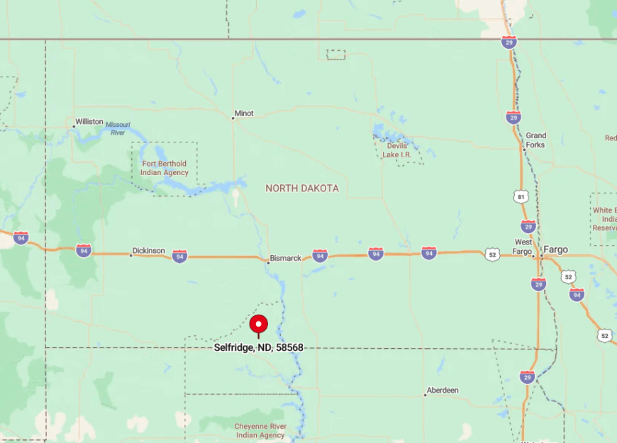
Located in Sioux County on the Standing Rock Reservation, Selfridge sits 65 road miles south of Mandan. Bluffs along the Missouri River and sprawling reservation rangeland envelop the area, reducing outside traffic.
The most direct approach follows State Highway 6 to Fort Yates, then a fifteen-mile county route west to town. Sparse signage and unlit roads reinforce the feeling of leaving modern bustle behind.
6. Havana – Lakeside Calm at the South Dakota Line
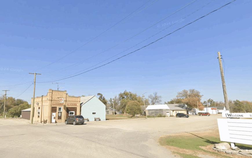
Havana’s 67 residents wake to the call of red-winged blackbirds over a chain of prairie pothole lakes that glimmer east of town. Kayakers ply the calm water of Grass Lake, and ice fishers set lines for perch once winter locks in.
Farming wheat, corn, and soybeans remains the primary occupation, with a handful of residents commuting to Forman for school and county jobs. The abandoned Milwaukee Road depot, now a photo favorite, hints at busier days long gone.
Distance from larger towns and the shielding effect of shelterbelt groves keep road noise to a whisper. Nighttime reveals undisturbed reflections of constellations on the lake surface.
Where is Havana?
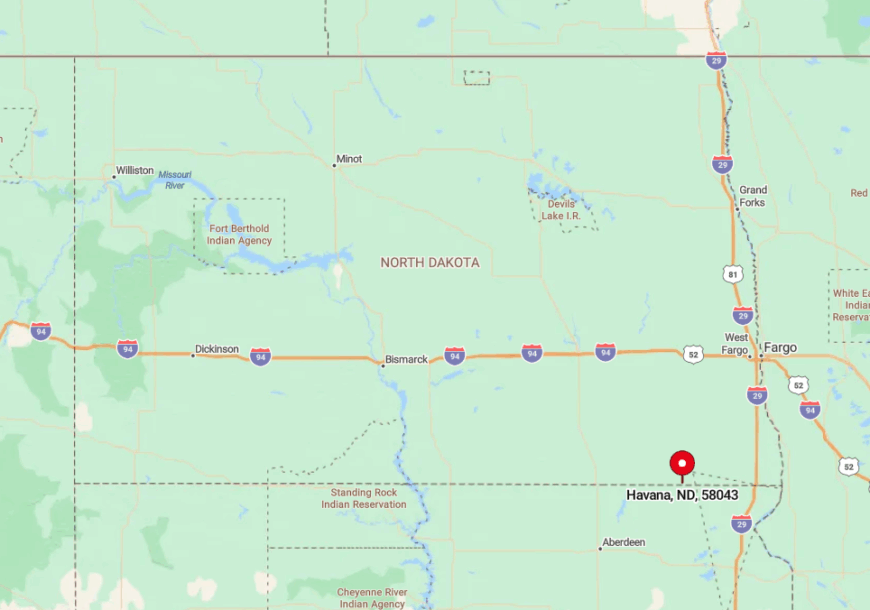
Havana occupies the southern edge of Sargent County, just two miles north of South Dakota and 50 miles west of Wahpeton. The town lies ten miles off State Highway 13, accessed by a narrow blacktop bordered by cropland.
Surrounding farm sections create a natural buffer that screens any sign of passing vehicles. Visitors usually exit at Cayuga, then follow County Road 3 until the church steeple emerges on the horizon.
5. Bucyrus – Reborn After the Wildfire
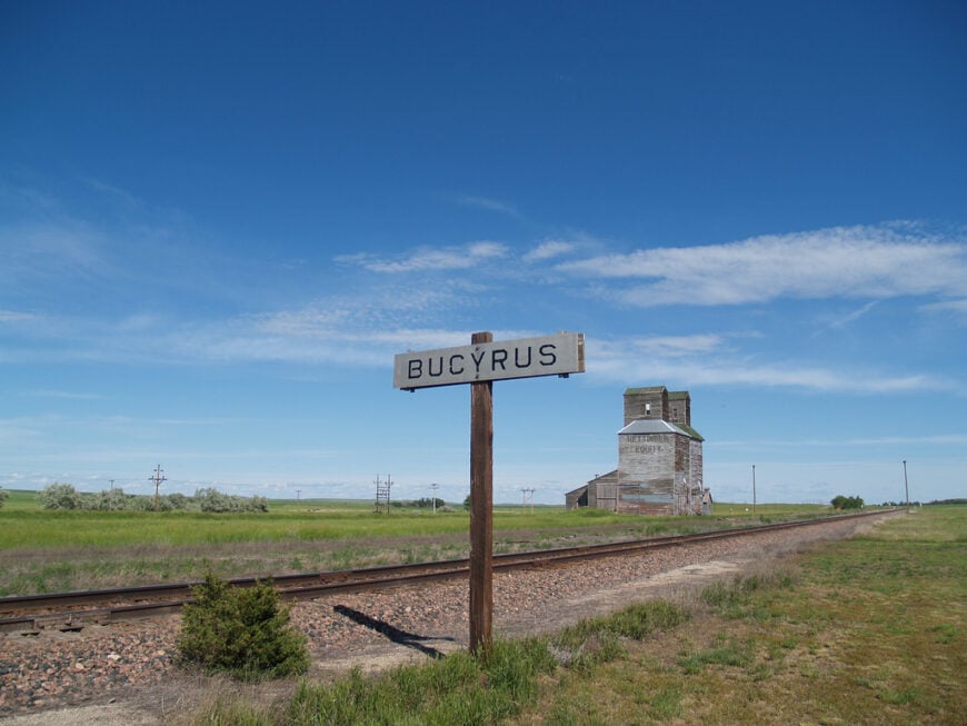
Bucyrus counts roughly 30 inhabitants who rebuilt on oversized lots following the 2012 wildfire that destroyed twenty-six homes. Today, new single-story houses sit among charred fence posts that sprout fresh prairie grasses, offering striking scenery for photographers and history buffs.
Residents engage in cattle ranching, custom hay cutting, and seasonal work tied to nearby oilfield service hubs in Bowman County. Community potlucks in the rebuilt fire hall double as storytelling sessions about survival and renewal.
The nearest grocery store lies 20 miles east in Bowman, ensuring that town streets stay quiet most days. Open grassland on all sides guarantees sunrise views without obstruction.
Where is Bucyrus?
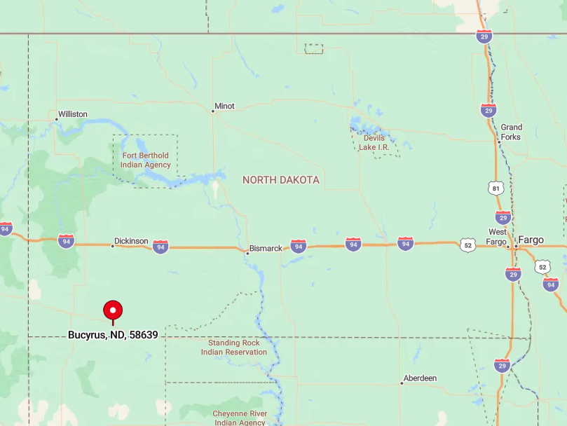
Bucyrus rests on U.S. Highway 12 in Adams County but still feels remote due to the vast pasture that surrounds it. Ninety miles separate the settlement from Dickinson, the closest city with commercial flights.
The BNSF rail line running parallel to the highway brings occasional freight but no passenger service, underlining the sense of remove. Drivers usually spot pronghorn before they meet another car on this stretch of road.
4. Fullerton – Timber Edges Meet Open Range
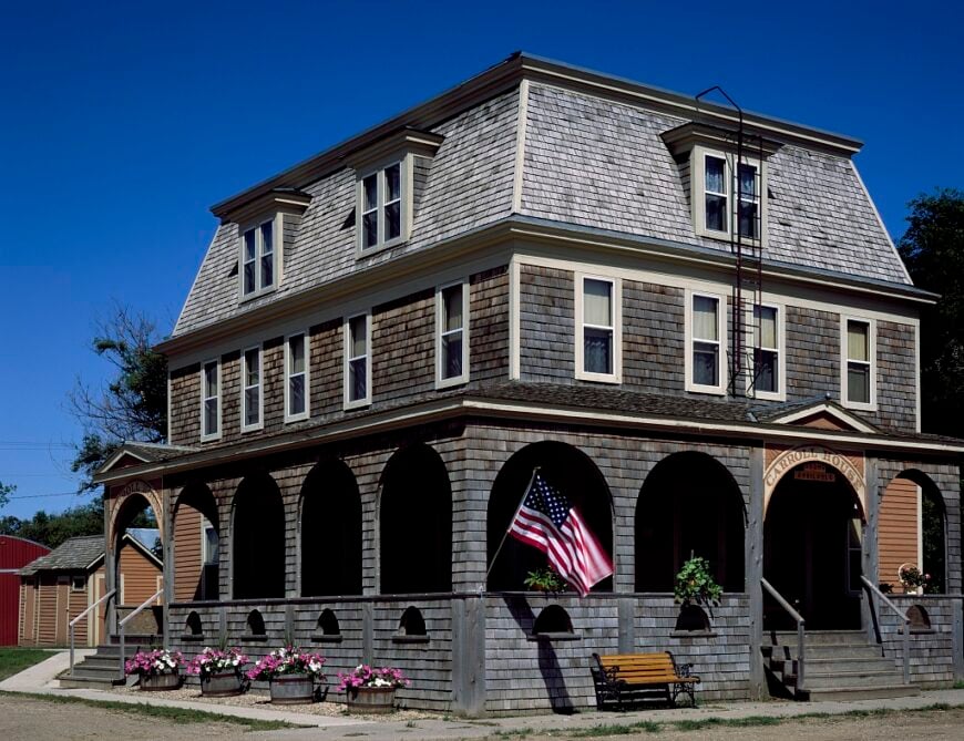
Fullerton’s 50 residents live among old brick storefronts fronting a broad main street once served by the Soo Line. Hunters target deer and pheasant in the adjacent Ellendale National Wildlife Management Area, while birders scan for elusive short-eared owls.
Grain farming and guided hunting leases form the economic bedrock, along with part-time work at nearby state game lands. Mile-wide buffers of wheat and corn separate the town from neighboring hamlets, muting any outside disturbance.
A historic hotel, now a private residence, stands as a silent sentinel over empty sidewalks. Even during fall harvest, the loudest sound may be a single combine rumbling in the distance.
Where is Fullerton?
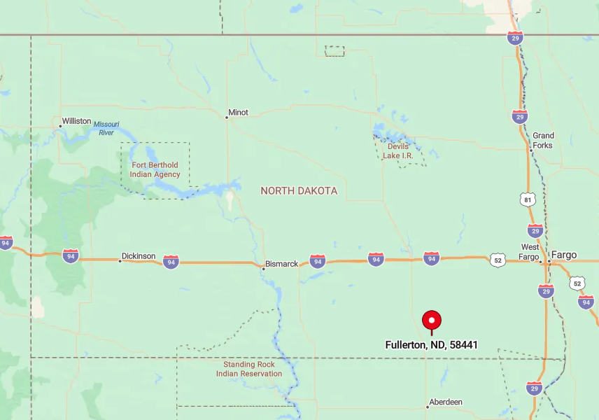
The town lies in Dickey County, 15 miles east of Ellendale on County Road 5. Shelterbelts and timber patches fringe the settlement, framing it like an island in a sea of cropland.
Travelers arrive by following State Highway 11 to Monango, then turning south and east on lightly marked county lanes. With no through routes, accidental traffic is virtually nonexistent.
3. Monango – Elevator on the Horizon
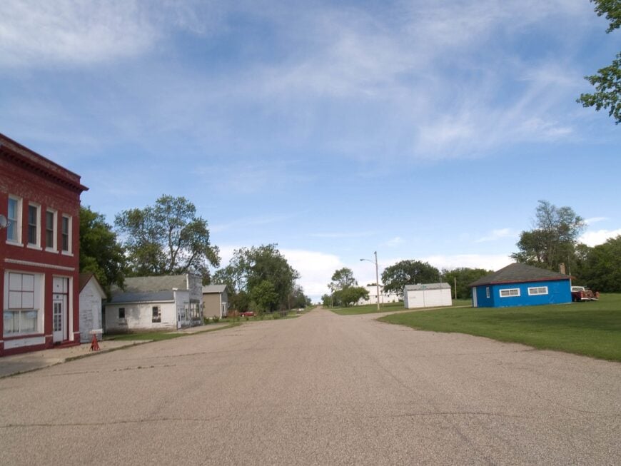
Monango hosts about 35 people and revolves around a solitary white grain elevator that rises above prairie grass like a lighthouse. Summer evenings bring youth baseball games on a dusty diamond, while autumn attracts rail fans eager to photograph unit trains loading corn.
Agriculture is the sole industry, with fields stretching unbroken for miles and a single scale house checking truck weights. A lack of retail, combined with simple gravel streets and minimal lighting, ensures deep quiet once the sun sets.
Meadowlarks provide the morning chorus, and wind rustling through brome grass supplies the background score. Residents value the ability to trace storms approaching from 30 miles away.
Where is Monango?
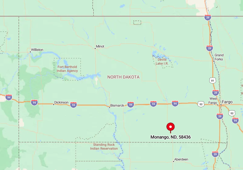
Monango rests seven miles north of Fullerton in northern Dickey County, midway between U.S. Highway 281 and State Highway 11. Surrounding sections of cropland act as a protective moat that discourages casual detours.
Reaching town involves a brief drive west from Highway 281 on County Road 2, then south down a gravel spur marked only by a modest sign. The nearest gas station stands 12 miles away in Ellendale, guaranteeing limited traffic.
2. Zeeland – Steeples Above the Sunflowers
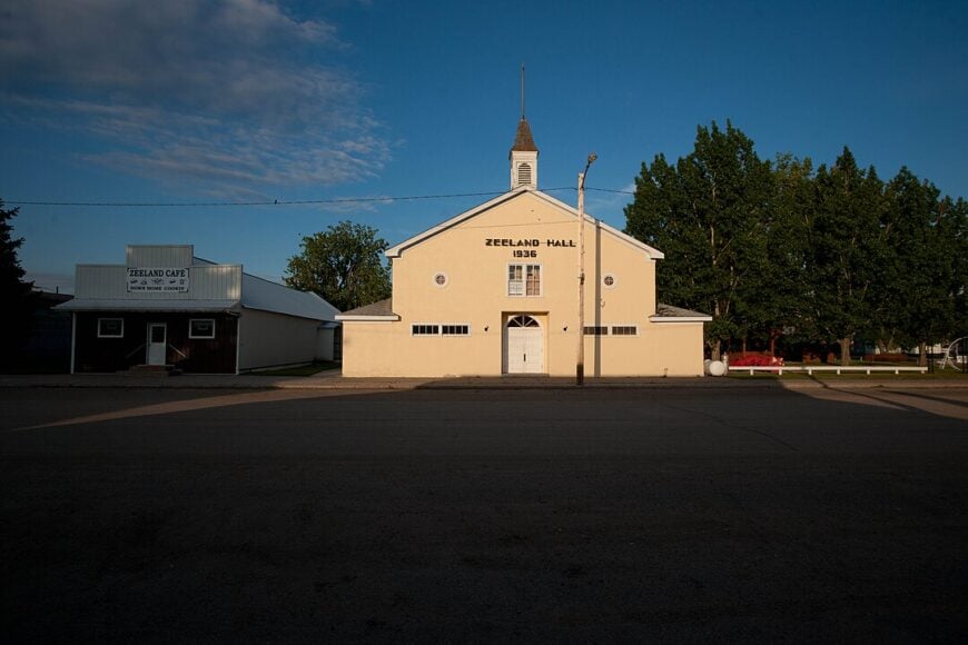
Zeeland counts nearly 85 residents whose days begin under the shadow of the ornate 1905 St. John the Baptist Church, its twin spires visible for miles. Visitors find photo opportunities among endless sunflower fields and the well-preserved German-Russian homestead museum on Main Street.
Farming, cattle, and a small grain-cleaning operation generate most of the local income, with a seasonal burst when sunflower harvest peaks. Natural hillocks deflect winter winds and provide a sense of enclosure, while the absence of chain businesses underscores the town’s separation from modern commercial corridors.
Even county fair weekends feel laid-back, with slow tractor parades down the two-block main drag. Clear nights reward patient stargazers with vivid views of the Milky Way arching over steeples and fields.
Where is Zeeland?
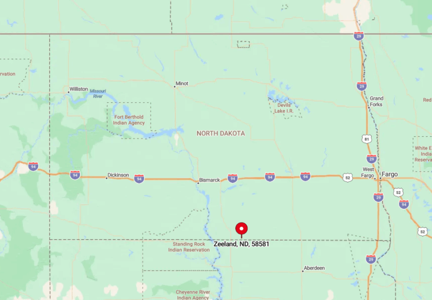
Zeeland sits in McIntosh County, 15 miles north of the South Dakota border and a similar distance east of the James River valley. The closest major route, U.S. Highway 83, lies a half-hour drive to the west, adding to the tucked-away charm.
Most visitors arrive via State Highway 11, then turn south onto a gently winding county blacktop flanked by rye fields. Traffic often consists of little more than grain trucks during harvest and churchgoers on Sunday mornings.
1. Forbes – Last Stop Before the State Line
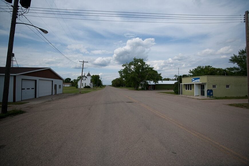
Only 30 residents keep the lights on in Forbes, where clapboard houses and a disused school sit behind wide shelterbelts that muffle every breeze. Anglers cast for walleye in nearby Pheasant Lake, and hunters stage out of town during waterfowl season, filling the lone café for early breakfasts.
Ranching and small-grain farming dominate livelihoods, supplemented by seasonal guiding for bird hunters. Seclusion comes easily when the nearest four-lane road lies more than an hour away and sprawling cattle pastures wrap the town on every side.
An aging wood-slat water tower, visible from five miles out, serves as both a landmark and a reminder of slower times. Town socials in the volunteer fire hall double as the week’s biggest event.
Where is Forbes?
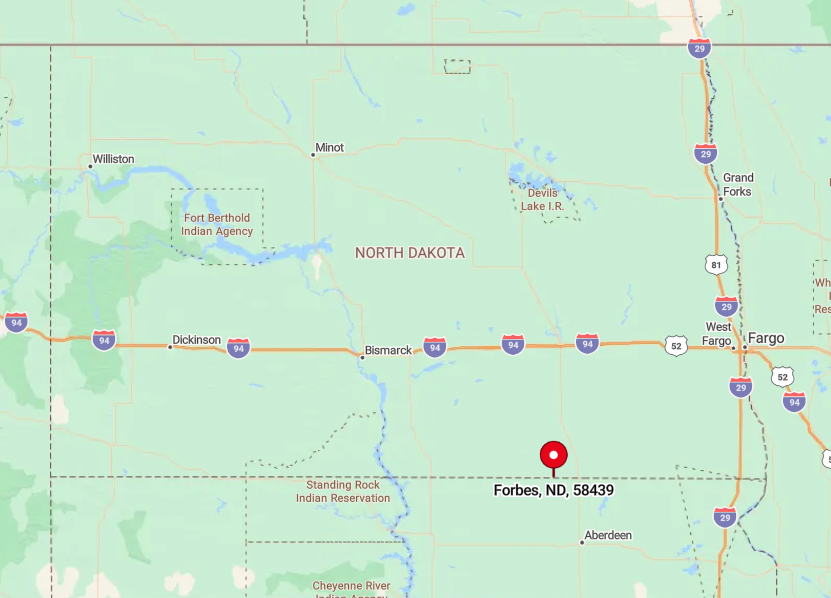
Forbes occupies the extreme southeast corner of Dickey County, a mere half-mile north of the South Dakota line. The settlement sits 15 miles from North Dakota Highway 11, connected by a single paved spur that ends on Main Street.
Rolling pasture, dotted with stock dams, absorbs any hint of highway noise, enhancing the quiet. Drivers generally spot grazing Herefords long before they glimpse another vehicle on the road to town.


