🔥 Would you like to save this?
Up in Maine’s crown, where the rivers bend toward Canada and the air holds the hush of spruce, a string of towns flows like a seam through generations. This is the St. John Valley—French-speaking, maple-tapped, quietly radiant. Here, language lingers like lichen on granite.
In Madawaska, elders speak Acadian French with the same ease they spread homemade butter on warm ployes. In Frenchville and Grand Isle, the signs read Bienvenue as a matter of fact, not formality.
In order to come up with the very specific design ideas, we create most designs with the assistance of state-of-the-art AI interior design software. Also, assume links that take you off the site are affiliate links such as links to Amazon. this means we may earn a commission if you buy something.
These towns don’t rush. Their beauty gathers slowly: in the orange swing of the sun over Long Lake, in the spiced scent of a church supper in St. Agatha, in the slow arc of a canoe sliding across Eagle Lake. Fort Kent offers the starting point of U.S. Route 1, but locals trace their roots back much further—across rivers, through exile, into songs carried like heirlooms.
The landscape here carries its stories in full view: grain silos against violet sky, snowmobile trails etched like signatures, birch groves swaying over fields. Solitude thrives, but so does connection—among neighbors, across borders, through language.
This is northeastern Maine unfiltered, unvarnished, unmistakably alive. A place shaped not by distance, but by depth.
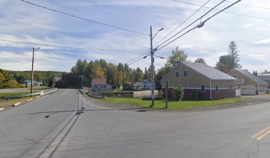
25. Orient: A Border Town by East Grand Lake
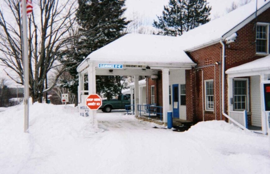
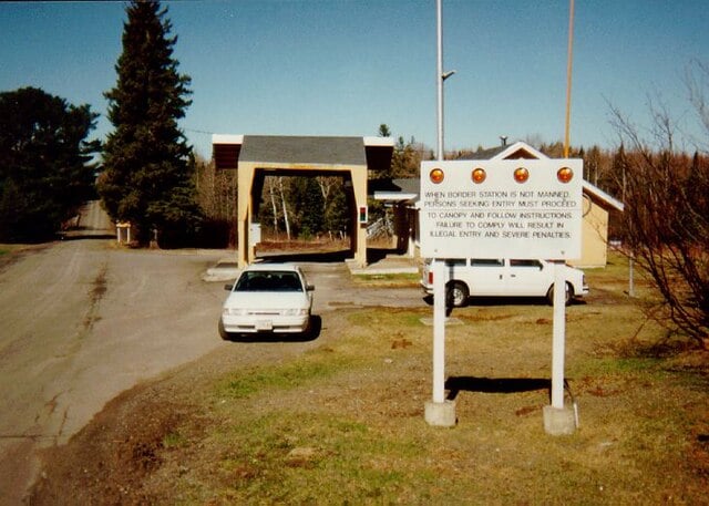
Tucked along the edge of East Grand Lake, Orient, Maine, feels like it exists in its own pocket of time. Far from major highways and pressed against the Canadian border, it’s where the outside world fades into the rustle of pines and the gentle lap of water.
Life moves slowly here, with mornings of mist over the lake and nights lit by starlight untouched by city glow. Days might be spent paddling the vast waters, fishing from an old dock, hiking wooded trails, or visiting a small general store that’s been here for generations.
In winter, snow-covered stillness replaces summer’s bustle, with ice fishing and snowmobile tracks marking the season. It’s the kind of place that reminds you how quiet the world can be.
Where is Orient?
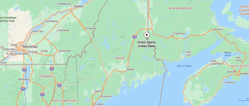
Orient sits in the far northeastern corner of Maine, right along the Canadian border in Aroostook County. It’s roughly 25 miles south of Houlton, reached by following U.S. Route 1 through stretches of open farmland and quiet forest.
The drive takes you along a two-lane road that winds past lakes and rolling hills before arriving in the small lakeside community. It’s close enough to the highway to find, but far enough to feel like you’ve stepped into another world.
24. Amity: A Forest-Framed Hamlet
In Amity, Maine, the road narrows until it feels like you’ve left the map behind. Surrounded by deep woods and open farmland, this small border town sits quietly against the edge of Canada.
Life here moves to the rhythm of the seasons, with summer days spent fishing in clear lakes, wandering forest paths, or visiting a neighbor’s farm stand. When winter settles in, snow blankets the fields and only the crunch of boots or the distant buzz of a snowmobile breaks the silence.
The town’s solitude comes from its remoteness and the steady, simple routines of those who call it home. It’s a place where the pace of life feels just right for those who value space and stillness.
Where is Amity?
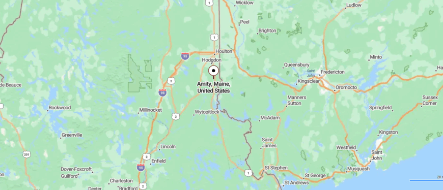
Amity lies in the eastern reaches of Aroostook County, Maine, just a few miles from the Canadian border. It sits about 20 miles south of Houlton, reached by traveling along U.S. Route 1 through farmland, forest, and open countryside.
The approach is a simple two-lane road that narrows as the houses grow fewer and the landscape opens wide. It’s the kind of place where the quiet stretches out, making you feel far removed from everything else.
23. Cary: Off-the-Map Quiet
Hidden in the northeastern stretch of Maine, Cary Plantation feels more like an extension of the forest than a town. Tall spruce and maple line the narrow roads, and the nearest bustle is many miles away.
The air is filled with the scent of pine, and the quiet is so complete you can hear wind moving through the trees. Visitors might spend the day canoeing on remote ponds, hiking through unmarked trails, or spotting wildlife in the thick woods.
Logging and small-scale farming tie people to the land, keeping life grounded in tradition. It’s the kind of quiet that settles into you, leaving a piece of the wilderness behind when you go.
Where is Cary?
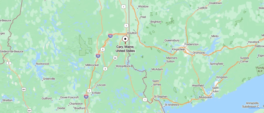
Cary Plantation rests in the southeastern part of Aroostook County, Maine, not far from the Canadian border. It’s located about 15 miles south of Houlton, reached by following U.S. Route 1 and then turning onto smaller rural roads that wind through forest and fields.
The journey brings you past long stretches of open land with only the occasional farmhouse in sight. It’s a spot where the road seems to slow time, leaving the bustle of elsewhere far behind.
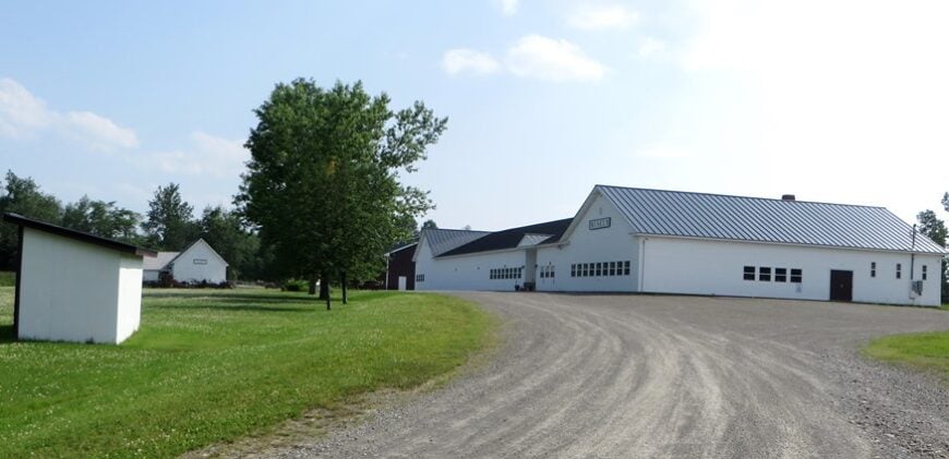
22. Hodgdon: Fields and Crossroads
Hodgdon, Maine, rests in a quiet pocket of Aroostook County where wide fields meet the edge of dense forest. Set away from major routes, the town’s pace is shaped by long farming days and the steady rhythm of rural life.
Mornings bring the sight of mist lifting off hayfields, while evenings end under skies lit with countless stars. Here, you might wander country backroads, fish in the Meduxnekeag River, or join a small-town gathering at the community hall.
Agriculture remains the backbone of the local economy, with generations tending the same soil. It’s the kind of place where the open land and open silence feel like a welcome invitation to stay awhile.
Where is Hodgdon?
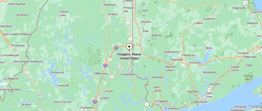
Hodgdon is tucked in southern Aroostook County, Maine, just a few miles south of Houlton and close to the Canadian border. You can reach it by following U.S. Route 1, where the drive shifts from small-town neighborhoods to open fields and wooded stretches.
The route is straightforward, yet it carries you into a quieter rhythm as the traffic thins and the scenery widens. It’s near enough to town for convenience, but distant enough to feel like the world has slowed down.
21. Littleton: Rolling Farmland at the Border
Littleton, Maine, sits quietly along the Canadian border, surrounded by rolling farmland and stretches of open sky. Its sense of seclusion comes from miles of rural roads and the absence of busy traffic, giving life here a steady, unhurried rhythm.
The air carries the scent of tilled earth in summer and woodsmoke in winter, marking the town’s deep connection to the land. Days can be spent walking field edges, fishing in nearby streams, or visiting a neighbor’s sugar shack during maple season.
Farming anchors much of the community, with fields that have been worked for generations. It’s a place where the horizon feels wide, and time itself seems in no rush to pass.
Where is Littleton?
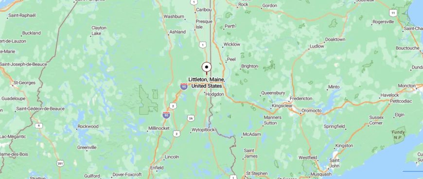
Littleton is located in southern Aroostook County, Maine, directly north of Houlton and just a short drive from the Canadian border. It’s reached by traveling along U.S. Route 1, where farmland and rolling fields line both sides of the road.
The approach is open and rural, with wide views that seem to stretch for miles. It’s close enough to connect with nearby towns, yet still feels wrapped in its own quiet expanse.
20. Monticello: Along the Meduxnekeag River
Monticello, Maine, rests along the Meduxnekeag River, where farmland meets stretches of untouched forest. Its quiet comes from being far from crowded towns, with only winding country roads linking it to the outside world.
The seasons set the pace—spring brings planting, summer hums with hayfields, and winter settles in with deep snow and stillness. Visitors might explore riverbanks, follow wooded trails, or stop by a roadside farm stand for fresh goods.
Agriculture and logging keep the community tied closely to the land. It’s the kind of place where the calm feels as steady as the flow of the river beside it.
Where is Monticello?
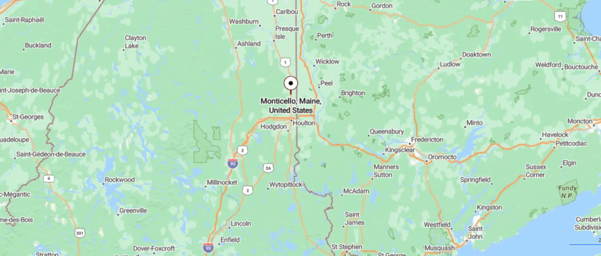
Monticello sits in southern Aroostook County, Maine, about 15 miles north of Houlton along U.S. Route 1 and near the Canadian border. The drive follows a two-lane highway through farmland, gentle hills, and patches of forest, with the scenery opening wider the farther you go.
Approaching the village, homes and barns appear between long stretches of open fields. It’s a place where the road feels unhurried, and the quiet settles in around you.
19. Bridgewater: Potato Country

🔥 Would you like to save this?
Bridgewater, Maine, lies in a broad valley of open farmland bordered by low, forested hills. Its seclusion comes from miles of quiet rural roads and the wide spaces between neighbors.
In summer, fields of potatoes and grain stretch toward the horizon, while winter turns the landscape into a snow-covered expanse under crisp, clear skies. A day here might include walking country lanes, birdwatching along hedgerows, or joining a seasonal harvest festival.
Farming remains the heart of the town’s livelihood, carried on through generations. It’s a place where the land shapes the days, and the stillness feels like part of the scenery.
Where is Bridgewater?
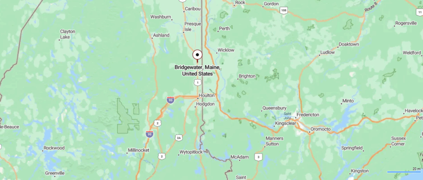
Bridgewater lies in southern Aroostook County, Maine, about 20 miles north of Houlton and just south of Mars Hill along U.S. Route 1. The drive takes you through rolling farmland and open fields, with distant hills marking the horizon.
Reaching the town means passing stretches of quiet countryside where traffic is rare and the views are wide. It’s the kind of place where the landscape itself seems to slow the pace of life.
18. Blaine: Hills and Horizons
Blaine, Maine, sits along the base of Mars Hill Mountain, where farmland rolls out in every direction. Its quiet nature comes from being surrounded by wide fields and forest, with only a handful of roads leading in or out.
The town moves with the seasons—spring planting, summer haying, and winter’s long hush under deep snow. Visitors might hike the nearby mountain, fish in small ponds, or browse a roadside stand for local produce.
Agriculture anchors the community, with potato farming as a long-standing tradition. It’s the kind of place where open skies and open land make the world feel a little bigger.
Where is Blaine?
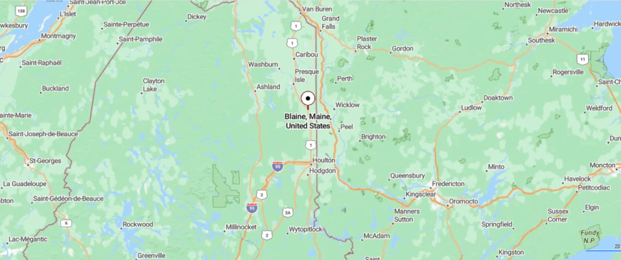
Blaine is set in southern Aroostook County, Maine, just north of Bridgewater and a short drive south of Mars Hill along U.S. Route 1. The approach follows a two-lane road bordered by farmland and open fields, with views that reach toward the distant hills.
As you near the town, clusters of homes and barns appear between long stretches of rural landscape. It’s easy to get to, yet the openness and quiet make it feel far from the rush of anywhere else.
17. Westfield: Between Fields and Forest

Westfield, Maine, is a small town where open fields give way to patches of dense forest and winding creeks. Its sense of seclusion comes from the long miles between neighbors and the steady hum of nature that fills the air.
On quiet mornings, mist rises from the lowlands, and the sound of a passing car is rare enough to turn heads. Visitors might walk the tree-lined rail trail, watch wildlife along the waterways, or explore old backroads that seem to lead nowhere fast.
Many here work in trades, forestry, or seasonal outdoor work, tied to the land in different ways. It’s a place where the days feel unhurried and the nights are lit only by the moon.
Where is Westfield?

Westfield rests in southern Aroostook County, Maine, about 10 miles south of Presque Isle along U.S. Route 1. The drive north or south brings you through wide stretches of farmland, where the road seems to follow the contours of the open fields.
As you enter the small community, the landscape remains spacious, dotted with farmhouses and silos. It’s a place where the horizon feels endless and the quiet settles in easily.
16. Mapleton: Gateway to the North Maine Woods

Mapleton, Maine, sits where wooded hills fold into open valleys, giving the town a sense of being cradled by the landscape. Its distance from larger centers keeps the nights dark and the mornings quiet, with only the sound of wind through the trees.
Autumn paints the hills in deep reds and golds, while winter brings a stillness broken by the crunch of snowshoes on fresh powder. A day here might be spent exploring backcountry trails, kayaking on calm waters, or browsing handmade goods at a small-town craft fair.
Work often follows the seasons, from logging in the cold months to outdoor trades and local services in summer. It’s the kind of place where each view feels untouched, as though it’s been waiting for you all along.
Where is Mapleton?
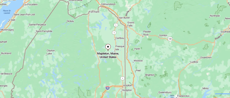
Mapleton sits in central Aroostook County, Maine, just west of Presque Isle and accessible via State Route 163. The drive passes through rolling farmland and stretches of forest, with open views that widen as you leave the city behind.
Entering town, you’ll find scattered homes and fields that seem to blend seamlessly into the surrounding countryside. It’s close enough for an easy trip to Presque Isle, yet it holds the stillness of a place apart.
15. Ashland: Along the Aroostook River

Ashland, Maine, rests at the gateway to the North Maine Woods, where vast stretches of forest seem to go on without end. Its seclusion comes from the sheer remoteness of its surroundings, with miles of logging roads and wilderness in every direction.
The scent of pine and the call of loons drift over the Aroostook River, setting a pace that feels timeless. Days might be filled with canoeing along quiet waterways, hiking into deep forest trails, or spotting moose in the early morning mist.
Timber and outdoor recreation keep the town connected to its rugged environment. It’s a place where the wilderness feels close enough to step into at any moment.
Where is Ashland?
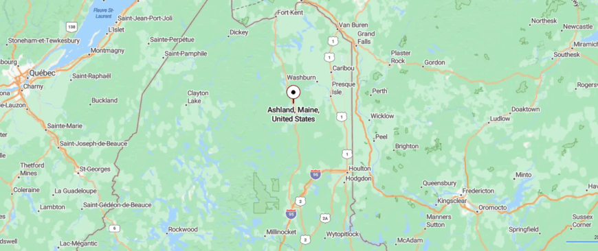
Ashland is located in western Aroostook County, Maine, about 20 miles northwest of Presque Isle, reached by following State Route 163 through farmland and forest. The road narrows as it winds along the Aroostook River, with stretches where trees close in before opening to broad valley views.
Approaching the town, the mix of wooded hills and open fields gives it a tucked-away feeling. It’s well within reach of larger towns, yet feels like a quiet gateway to Maine’s vast northern wilderness.
14. Portage Lake: Water and Wilderness

Portage Lake, Maine, unfolds along the calm waters it’s named for, with forested hills rising gently in the distance. Its quiet comes from being miles away from heavy traffic, where the sound of waves against the shore is louder than any road.
Summer days invite kayaking across the lake, casting a line for trout, or picnicking on the small sandy beach, while autumn brings a ring of fiery color to the shoreline. Winter transforms the scene into a white expanse for ice fishing, snowshoeing, and quiet walks under frosted branches.
Many who live here build their days around the lake, whether through guiding, seasonal rentals, or simply enjoying its beauty. It’s the kind of place where the water seems to hold the heart of the town.
Where is Portage Lake?
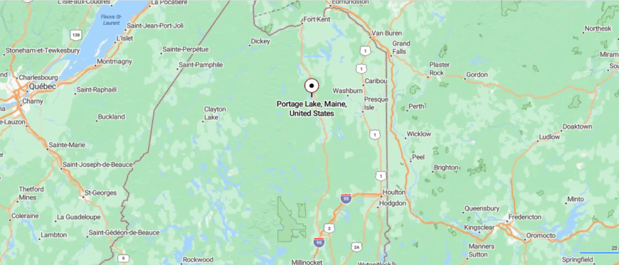
Portage Lake lies in western Aroostook County, Maine, about 35 miles northwest of Presque Isle, reached by traveling along State Route 11 through long stretches of forest and occasional clearings.
The drive follows a scenic route where glimpses of water and mountains appear between stands of spruce and birch. As you near town, the road opens to reveal the wide, shimmering expanse of the lake at its center. It’s a place where the journey itself feels like leaving the rest of the world behind.
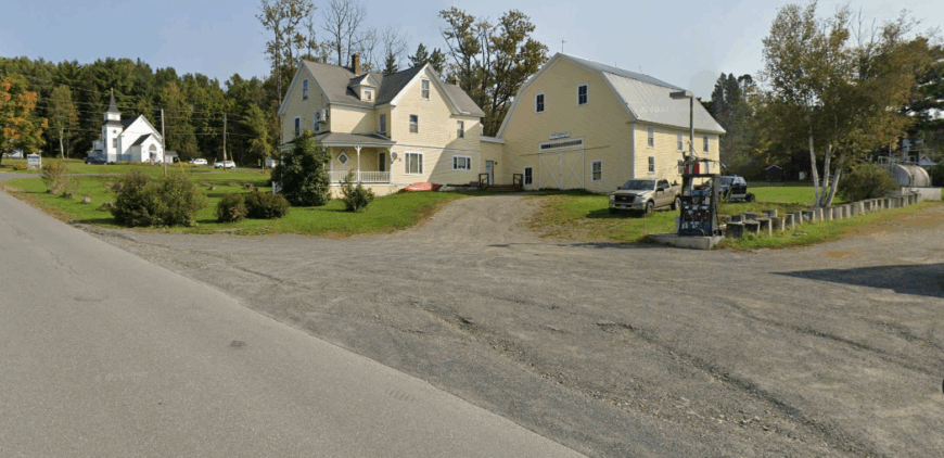
13. Washburn: Fields Beside the Aroostook River
🔥 Would you like to save this?
Washburn, Maine, sits along the Aroostook River, surrounded by a patchwork of fields, wetlands, and forest. Its sense of seclusion comes from the quiet backroads that wind through open countryside, far from crowded centers.
Early mornings bring a light mist over the river, while evenings often end with the soft glow of sunsets stretching across the valley. Visitors might paddle along the river’s bends, explore nearby nature preserves, or follow old trails that cut through the woods.
Local life is shaped by small businesses, outdoor work, and a close-knit community that values its slower pace. It’s a place where the landscape feels as much a neighbor as the people who live there.
Where is Washburn?
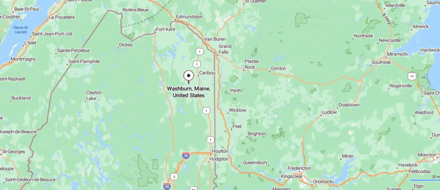
Washburn is set in central Aroostook County, Maine, about 10 miles west of Presque Isle and accessible via State Route 164. The route passes through open farmland and gentle hills, with the Aroostook River winding alongside parts of the drive.
Entering town, the landscape stays wide and uncluttered, dotted with homes and barns. It’s close to the conveniences of the city, yet feels firmly rooted in quiet, rural space.
12. Stockholm: Swedish Roots in the Valley
Stockholm, Maine, is tucked into the northern reaches of the state, surrounded by rolling forest and quiet waterways. Its distance from larger towns gives it a peaceful, almost hidden quality, where the hum of traffic is replaced by the sound of wind through the trees.
Traces of the town’s Swedish heritage appear in its architecture and community gatherings, adding a unique cultural note to its rural setting. Days here might be spent kayaking on the Madawaska River, exploring scenic backroads, or attending a local festival that celebrates old traditions.
Small-scale businesses and seasonal tourism help sustain the community without disturbing its calm. It’s the kind of place where history, culture, and wilderness seem to share the same gentle rhythm.
Where is Stockholm?
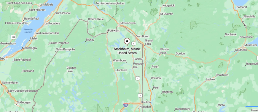
Stockholm sits in the northwestern part of Aroostook County, Maine, about 20 miles northwest of Caribou, reached by following a series of rural roads that wind through farmland and forest.
The approach is a peaceful drive past open fields, small lakes, and stands of spruce and fir. As you arrive, the village feels gently tucked into the surrounding hills and waterways. It’s accessible, yet carries the calm of a place far from life’s usual pace.
11. New Sweden: A Scandinavian Enclave

New Sweden, Maine, rests in the quiet north, where open fields meet dense stands of spruce and fir. Its remote setting and sparse population give it a stillness that feels far removed from the pace of modern life.
The town’s strong Swedish roots are reflected in its Lutheran churches, traditional festivals, and place names that honor its heritage. Visitors might explore country roads lined with old farmhouses, attend Midsommar celebrations, or hike nearby trails that wind through forest and meadow.
Local livelihoods blend forestry, small farming, and cultural tourism, keeping traditions alive while embracing the landscape. It’s a place where history lingers in the air as clearly as the scent of pine after rain.
Where is New Sweden?

New Sweden is located in north-central Aroostook County, Maine, about 15 miles west of Caribou and reached via quiet rural roads branching from State Route 161. The drive leads through rolling farmland, forest edges, and open fields that stretch toward the horizon.
As you enter the community, clusters of homes and barns appear amid wide expanses of countryside. It’s near enough to connect with neighboring towns, yet holds the peaceful distance of a place apart.
10. Van Buren: A Gateway to the St. John Valley
Van Buren sits like a punctuation mark at the edge of Maine, where Route 1 almost winks at New Brunswick across the river. Its presence is modest, but its story reaches deep—into Acadian exile, Francophone roots, and the stubborn comfort of staying put. Named after a U.S. president few remember but bordered by a culture few could forget, the town carries both its name and its heritage with a quiet steadiness.
Walk its streets and you’ll hear French—not the Parisian kind, but Acadian French, weathered and warm, passed down like a favorite quilt. The Acadian Village historical site, with its preserved cabins and chapel, doesn’t feel curated; it feels remembered. Even the potato fields hum a bit in two languages.
The town draws no crowds. And that’s the appeal. One can sit along the St. John River and watch water cross international lines like it never got the memo about borders. The sky here is big, even in winter, and when the snow piles high, Van Buren stays open in its own quiet way—welcoming, resolute, never hurried.
It’s a place where you’re more likely to be invited in for ployes and bean-hole beans than pointed toward a gift shop. The stories come slowly, and only if you listen. But they’re there—in the language, in the earth, in the old storefronts, in the voices that speak of both belonging and endurance.
Where is Van Buren?

Van Buren is located in Maine’s Aroostook County, nestled along the easternmost stretch of the St. John River. It directly faces the Canadian town of Saint-Léonard, New Brunswick, with a border crossing linking the two. U.S. Route 1 curves north into town, making Van Buren the gateway to the upper St. John Valley. The town is roughly 20 miles northeast of Caribou and 40 miles from the terminus of Interstate 95 in Houlton.
Despite its location at the edge of the state, Van Buren feels connected—culturally to the Acadian Francophone communities across the river, and geographically to the expansive potato fields and forestlands that characterize northern Maine. The surrounding landscape opens up to rolling farmland, spruce woods, and long river views. It is remote, but rooted. The town’s orientation along the water gives it both a sense of separation and flow—perfectly situated at a seam rather than a fringe.
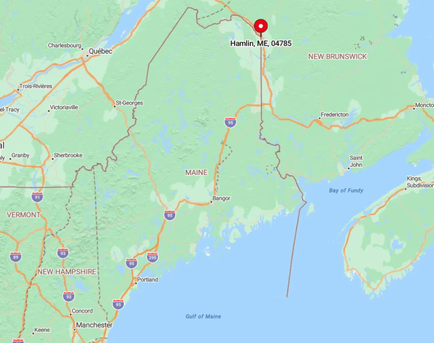
9. Hamlin: A Quiet Border Community

Hamlin is a small, peaceful town in northeastern Maine, located along the U.S.-Canada border. With its rolling hills and scenic views of the St. John River, Hamlin offers a tranquil escape for those seeking solitude and natural beauty.
The town’s history is closely tied to agriculture, and its rural landscape reflects this heritage. Visitors can enjoy the serene surroundings, including Hammond Brook and Cyr Hill, which offer opportunities for hiking and wildlife observation.
Hamlin’s proximity to the St. John River adds to its appeal, providing a picturesque backdrop for outdoor activities. With its unspoiled landscapes and welcoming community, Hamlin is a hidden treasure in Aroostook County.
Its combination of natural beauty and rural charm makes it an ideal destination for those looking to unwind and reconnect with nature.
Where is Hamlin?
🔥 Would you like to save this?
Hamlin is located in northeastern Maine, just south of Van Buren, along U.S. Route 1A. Its position on the St. John River and the Canadian border enhances its sense of seclusion and natural beauty.
To reach Hamlin, take Route 1A, enjoying the peaceful drive through the countryside. The town’s location, surrounded by rolling hills and farmland, ensures a serene and memorable visit.
Hamlin’s unique blend of accessibility and tranquility makes it a perfect destination for those seeking a quiet retreat in northeastern Maine. Whether you’re drawn by its history, outdoor activities, or scenic views, Hamlin has something special to offer.
8. Grand Isle: A Scenic Town in the St. John Valley

Grand Isle is a picturesque town in northeastern Maine, known for its stunning views of the St. John River and its rich Acadian heritage. This small community offers a peaceful atmosphere and a strong sense of tradition, making it a delightful place to visit.
The town is home to several historical landmarks, including the Grand Isle Historical Society Museum, which provides a glimpse into the area’s past.
Outdoor enthusiasts can enjoy activities like hiking, fishing, and birdwatching in the surrounding forests and along the riverbanks. Grand Isle’s serene environment and cultural significance make it a unique destination in Aroostook County.
With its blend of natural beauty and historical charm, Grand Isle is a hidden gem in the St. John Valley. Its combination of outdoor activities and cultural attractions ensures a memorable experience for all who visit.
Where is Grand Isle?
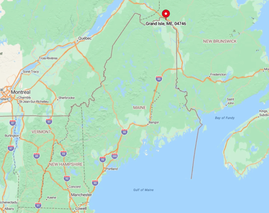
Grand Isle is located in northeastern Maine, along the St. John River, near the Canadian border. The town is easily accessible via U.S. Route 1, which runs through the heart of the community.
To reach Grand Isle, follow Route 1 north, enjoying the scenic drive through the St. John Valley’s rolling hills and farmland. The town’s location, surrounded by natural beauty and historical sites, ensures a peaceful and enriching visit.
Grand Isle’s unique position in the St. John Valley, combined with its rich cultural heritage, makes it a special place to explore. Whether you’re drawn by its history, outdoor adventures, or tranquil environment, Grand Isle has something to offer everyone.
7. Madawaska: The Gateway to Acadian Culture
Madawaska is a vibrant town in northeastern Maine, located along the St. John River and directly across the border from Edmundston, New Brunswick. Known as the “Gateway to Acadian Culture,” this community celebrates its rich Franco-American heritage through festivals, traditions, and everyday life.
The town has a strong sense of identity and the residents take pride in their Acadian roots. The annual Acadian Festival is a highlight, featuring music, dance, and cuisine that showcase the region’s unique cultural blend.
Visitors can also explore the Four Corners Park, a monument marking Madawaska as one of the northernmost points in the contiguous United States. The town’s proximity to the North Maine Woods offers opportunities for hiking, fishing, and enjoying the pristine wilderness.
With its welcoming community and cultural significance, Madawaska is a special place in Aroostook County. Its combination of historical landmarks and natural beauty ensures a memorable experience for anyone visiting this corner of Maine.
Where is Madawaska?
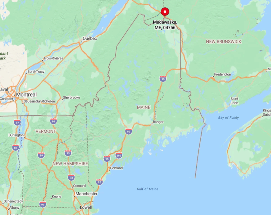
Madawaska is located in northeastern Maine, right on the Canadian border, connected to Edmundston by the Edmundston-Madawaska Bridge. The town is easily accessible via U.S. Route 1, which runs through its center.
To reach Madawaska, follow Route 1 north, enjoying the scenic drive through the St. John Valley’s rolling hills and farmland. The town’s location along the river provides stunning views and a sense of tranquility that’s hard to find elsewhere.
Madawaska’s unique position as a border town, combined with its rich cultural heritage, makes it a fascinating destination. Whether you’re drawn by its history, outdoor activities, or vibrant community, Madawaska has something to offer everyone.
6. Frenchville: A Quiet Town with Acadian Charm

Frenchville is a small, peaceful town in northeastern Maine, nestled along the St. John River. With its rolling hills and picturesque landscapes, Frenchville offers a tranquil escape for those seeking solitude and natural beauty.
The town is steeped in Acadian heritage, with landmarks like the St. Luce Catholic Church and the Frenchville Historical Society’s caboose, which showcases the area’s rich history.
Visitors can enjoy outdoor activities such as fishing, kayaking, and hiking along the riverbanks. Frenchville’s serene environment and cultural significance make it a unique destination in Aroostook County.
With its unspoiled landscapes and welcoming community, Frenchville is a hidden treasure in the St. John Valley. Its combination of natural beauty and historical charm makes it an ideal destination for those looking to unwind and reconnect with nature.
Where is Frenchville?

Frenchville is located in northeastern Maine, along the St. John River, near the Canadian border. The town is easily accessible via U.S. Route 1, which runs through its center.
To reach Frenchville, follow Route 1 north, enjoying the peaceful drive through the countryside. The town’s location, surrounded by rolling hills and farmland, ensures a serene and memorable visit.
Frenchville’s unique blend of accessibility and tranquility makes it a perfect destination for those seeking a quiet retreat in northeastern Maine. Whether you’re drawn by its history, outdoor activities, or scenic views, Frenchville has something special to offer.
5. St. Agatha: A Lakeside Gem in Northern Maine

St. Agatha is a charming town in northeastern Maine, located on the shores of Long Lake. Known for its stunning waterfront views and peaceful atmosphere, St. Agatha offers a perfect blend of natural beauty and small-town charm.
The town is home to Long Lake, a 6,000-acre body of water that attracts visitors year-round for fishing, boating, and ice fishing.
St. Agatha also features recreational facilities like snowmobile and ATV trails, making it a hub for outdoor enthusiasts. Its rich Acadian heritage is celebrated through local events and traditions, adding to its appeal as a cultural destination.
With its blend of natural beauty and cultural significance, St. Agatha is a hidden gem in Aroostook County. Its combination of outdoor activities and welcoming atmosphere ensures a memorable experience for all who visit.
Where is St. Agatha?

St. Agatha is located in northeastern Maine, along the northwest shore of Long Lake, near the Canadian border. The town is easily accessible via Maine Route 162, which runs through its center.
To reach St. Agatha, follow Route 162, enjoying the scenic drive along the lake and through the countryside. The town’s location, surrounded by natural beauty and historical sites, ensures a peaceful and enriching visit.
St. Agatha’s unique position in the St. John Valley, combined with its lakeside charm, makes it a special place to explore. Whether you’re drawn by its history, outdoor adventures, or tranquil environment, St. Agatha has something to offer everyone.
4. Sinclair: A Lakeside Village in the North Maine Woods
Sinclair is a small, unincorporated village in northeastern Maine, located on the western shore of Long Lake. Nestled within the Square Lake unorganized territory, Sinclair offers a tranquil setting surrounded by pristine forests and waterways.
The village is a hub for outdoor activities, with Long Lake providing opportunities for fishing, boating, and kayaking.
Visitors can also explore nearby trails and enjoy wildlife observation in the surrounding woods. Sinclair’s serene environment and close-knit community make it a perfect destination for those seeking solitude and natural beauty.
With its blend of lakeside charm and outdoor adventures, Sinclair is a hidden gem in northeastern Maine. Its combination of recreational opportunities and welcoming atmosphere ensures a memorable experience for all who visit.
Where is Sinclair?

Sinclair is located in northeastern Maine, within the Square Lake unorganized territory of Aroostook County. The village is accessible via Maine State Route 162, which runs through its center and connects it to nearby towns.
To reach Sinclair, follow Route 162, enjoying the scenic drive along Long Lake and through the North Maine Woods. The village’s location, surrounded by natural beauty and waterways, ensures a peaceful and enriching visit.
Sinclair’s unique position on Long Lake, combined with its tranquil environment, makes it a special place to explore. Whether you’re drawn by its outdoor activities, lakeside charm, or serene surroundings, Sinclair has something to offer everyone.
3. Eagle Lake: A Gateway to the Allagash Wilderness Waterway

Eagle Lake is a picturesque town in northeastern Maine, located on the shores of its namesake lake. Known for its stunning waterfront views and proximity to the Allagash Wilderness Waterway, Eagle Lake offers a perfect blend of natural beauty and outdoor adventures.
With its blend of outdoor activities and scenic landscapes, Eagle Lake is a hidden gem in northeastern Maine. Its combination of recreational opportunities and welcoming community ensures a memorable experience for all who visit.
Where is Eagle Lake?

Eagle Lake is located in northeastern Maine, within Aroostook County. The town is accessible via Maine Route 11, which runs through its center and connects it to nearby communities.
To reach Eagle Lake, follow Route 11, enjoying the scenic drive through the North Maine Woods and along the lake’s shoreline. The town’s location, surrounded by natural beauty and wilderness, ensures a peaceful and enriching visit.
Eagle Lake’s unique position as a gateway to the Allagash Wilderness Waterway, combined with its tranquil environment, makes it a special place to explore. Whether you’re drawn by its outdoor activities, lakeside charm, or serene surroundings, Eagle Lake has something to offer everyone.
2. Wallagrass: A Rural Retreat Along the Fish River

Wallagrass is a small town in northeastern Maine, located along the Fish River and just south of Fort Kent. Known for its rural charm and scenic landscapes, Wallagrass offers a peaceful setting surrounded by rolling hills and forests.
The town is home to Soldier Pond, a popular spot for fishing, kayaking, and canoeing.
Visitors can also explore the Fish River Greenway, which offers trails for hiking and wildlife observation. Wallagrass’s rich Acadian heritage is evident in its cultural traditions and welcoming community, making it a unique destination in Aroostook County.
With its blend of natural beauty and rural charm, Wallagrass is a hidden treasure in northeastern Maine. Its combination of outdoor activities and cultural significance ensures a memorable experience for all who visit.
Where is Wallagrass?

Wallagrass is located in northeastern Maine, within Aroostook County. The town is accessible via Maine Route 11, which runs through its center and connects it to nearby communities like Fort Kent and Eagle Lake.
To reach Wallagrass, follow Route 11, enjoying the scenic drive along the Fish River and through the countryside. The town’s location, surrounded by natural beauty and waterways, ensures a peaceful and enriching visit.
Wallagrass’s unique position along the Fish River, combined with its tranquil environment, makes it a special place to explore. Whether you’re drawn by its outdoor activities, rural charm, or serene surroundings, Wallagrass has something to offer everyone.
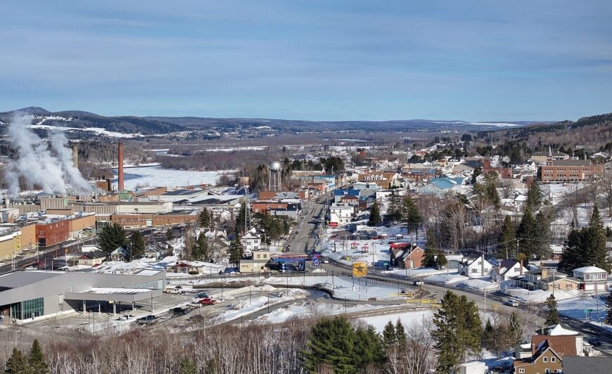
1. Fort Kent: A Historic Town at the Northern Tip of Maine

Fort Kent is a vibrant town in northeastern Maine, located at the confluence of the Fish River and the St. John River. Known for its rich history and cultural significance, Fort Kent offers a unique blend of natural beauty and community spirit.
The town has a strong connection to its Acadian heritage and has a welcoming atmosphere. The Fort Kent Blockhouse, a historic site from the Aroostook War, is a must-visit for history enthusiasts.
The town is also home to the northern terminus of U.S. Route 1, which stretches all the way to Key West, Florida. Outdoor activities abound, with opportunities for canoeing, fishing, and hiking in the surrounding wilderness.
Fort Kent’s vibrant community and seasonal events, like the CAN-AM dogsled race, add to its appeal as a destination. With its blend of historical landmarks and outdoor adventures, Fort Kent is a hidden gem in Aroostook County.
Its combination of cultural significance and scenic landscapes ensures a memorable experience for all who visit.
Where is Fort Kent?

Fort Kent is located in northeastern Maine, within Aroostook County. The town is accessible via Maine Route 161 and U.S. Route 1, which runs through its center and connects it to nearby communities.
To reach Fort Kent, follow Route 161, enjoying the scenic drive through the St. John Valley and along the rivers. The town’s location, surrounded by natural beauty and historical sites, ensures a peaceful and enriching visit.
Fort Kent’s unique position at the northern tip of Maine, combined with its rich history and vibrant community, makes it a special place to explore. Whether you’re drawn by its cultural heritage, outdoor activities, or welcoming atmosphere, Fort Kent has something to offer everyone.


