Eastern Missouri’s back roads thread into a geography that shifts quickly—river bottoms giving way to oak ridges, fields broken by knobs of granite, and valleys where towns still measure distance in miles to the next feed store. These are places that remain intact not by design but by topography and pace.
In order to come up with the very specific design ideas, we create most designs with the assistance of state-of-the-art AI interior design software.
The pull of St. Louis is never far, yet many of these communities resist its orbit. A few are tucked along the Missouri River bluffs, where vineyards and bike trails mark a subtle connection to the metro. Others lie two hours deeper in the Ozarks, their boundaries shaped by creeks, forests, and the long arcs of two-lane highways.
Daily life follows patterns that outsiders notice only after slowing down—midweek church suppers, autumn cattle auctions, and the seasonal traffic of float trips or hunters. Local economies are modest: timber, small farms, tourism that arrives on weekends, and county offices that keep the courthouse towns functioning.
Taken together, these settlements form a map of quiet persistence. They are not frozen in time but carry their histories into the present with little fuss: old stone jails turned quilt shops, schoolhouses hosting bluegrass nights, and mills converted into parks. Eastern Missouri’s secluded towns remain less a destination than a rhythm—steady, local, and durable.
25. Coffman – Vineyard Backroads by Hawn State Park

Coffman is a whisper of a hamlet where gravel dust hangs in the afternoon light and vineyard rows march toward oak-shadowed ridges. Its seclusion comes from long distances between homesteads and a web of lettered farm roads that end in pasture or woods.
The vibe is rustic and unhurried—tasting rooms with porch swings, clapboard churches, and the faint clink of bottles in barn-side cellars. Spend a morning hiking Pickle Creek’s pink granite at nearby Hawn State Park, then stroll winery lawns, photograph hay bales at sunset, or birdwatch along spring-fed creeks.
Farming, grapes, and weekend tastings keep the local rhythm steady. Nights fall dark and starry, with only crickets and the sigh of wind in the vines. It’s the kind of corner that reminds you how gentle a day can be.
Where is Coffman?

Coffman sits in Ste. Genevieve County, about 18 miles southwest of Ste. Genevieve and the Mississippi River. Most visitors come off I-55 to MO-32, then slip onto narrow county routes that fold into vineyards and woods.
There’s no real main street—just crossroads and mailbox clusters. It’s close enough for a day trip, but far enough to feel like you’ve stepped off the map.
24. Farrar – A Lutheran Steeple in Open Country

Farrar is little more than a steeple, a schoolhouse, and a handful of farm lanes stitched to the horizon. The settlement feels tucked away by design, buffered by wide cornfields and low traffic that never quite reaches a hum.
You’ll hear the echo of church bells, the clatter of grain augers, and not much else. Drop by the historic church, walk the tidy cemetery, photograph quilt-pattern fields, or detour to country bakeries and roadside stands.
Row crops and cattle are the main paychecks here, with a few craft businesses operating from barns. Evenings glow soft gold across the ridges. It’s the kind of quiet that settles into your pockets.
Where is Farrar?

You’ll find Farrar in Perry County, roughly 14 miles east of Perryville and a few ridges west of the Mississippi. Access is via MO-C and smaller county roads that favor right angles and slow speeds.
There’s no highway roar—only tires on chip-seal and wind in the grass. Once you arrive, the fields do most of the talking.
23. Redford – Black River Meadows and Gravel Bars

Redford spreads along the bottomland where the Black River bends, with homes set back behind sycamores and fence lines. Its seclusion comes from river loops and forested hills that turn roads into long, scenic detours.
The vibe is barefoot and river-simple: jon boats at dawn, porch fans at noon, and campfire smoke after dark. Wade quiet gravel bars, cast for smallmouth, amble shady lanes, or run up to Clearwater Lake overlooks for sunset.
Logging, guiding, and seasonal cabin rentals help stitch together the work week. Night brings owls and a sky clean enough to count satellites. It’s a little pocket of summer that lasts all year.
Where is Redford?

Redford sits in Reynolds County, about 12 miles northwest of Ellington along MO-O and MO-K. You reach it by leaving MO-21/72 for smaller routes that hug the river.
Cell signal fades as the hills rise and the pavement narrows. It’s near enough for supplies, far enough to feel like a secret swim hole.
22. Des Arc – Iron County Switchbacks and Storefront Calm

Des Arc keeps a soft profile—old storefronts, shade trees, and trains that slide by like a memory. It feels secluded because the surrounding hills turn every approach into a set of switchbacks, and the nearest four-lane is a long way off.
Mornings smell of woodsmoke and wet rock after a rain; afternoons are for front-porch talk. Visit the historic depot, fish local creeks, drive scenic MO-49, or wander to shut-ins and cascades in the nearby highlands.
Timber and small shops anchor daily life. When the sun drops behind the knobs, the town exhales, and the crickets take over. Des Arc is a slow page you’re glad to linger on.
Where is Des Arc?

You’ll find Des Arc in southern Iron County, roughly 20 miles south of Ironton along MO-49. Reaching it means winding through the forest, with grades that ask for patience and good brakes.
There’s no quick bypass—only a quiet two-lane. The last miles feel like a rehearsal for stillness.
21. Centerville – A Courthouse in a Bowl of Hills

Centerville is a county seat that never learned to hurry, a brick courthouse ringed by porches and shade. Seclusion is baked in by tall ridges that guard the hollow and keep radio and cell signals shy.
The town vibe is neighborly and practical—feed store chatter, church suppers, and trucks nosing out from gravel drives. Walk the courthouse square, picnic by the West Fork Black River’s nearby swimming holes, drive leaf-tunneled roads, or scout elk and wild turkey on forest edges.
Timber, county offices, and a few cafes shape the week. Stars return early as the hills pull night down. It’s the kind of bowl that keeps echoes kind.
Where is Centerville?

Centerville sits in central Reynolds County, about 17 miles west of Ellington along MO-21. Approaches are winding and hemmed by national forest on nearly every side.
Services are sparse once you leave the highway. It’s easy to reach—and easier to forget the rest of the world once you do.
20. Black – Pine Ridges Above a Namesake River

Black is a name and a ridge, a scatter of homes where pines shoulder up to pasture. Its seclusion comes from long distances between mailboxes and roads that lift and curl over the Ozark folds.
The mood is elemental: chainsaws in the distance, a dog’s single bark, and the hush of needles underfoot. Paddle or fish the Black River, hike to nearby shut-ins, prowl old logging spurs for spring wildflowers, or chase misty sunrise photos along high pastures.
Logging and ranching mix with a trickle of cabin rentals. At night, the forest writes its own soundtrack. Black is a dot that feels like a landscape.
Where is Black?

Black lies in Reynolds County along MO-49, about 10 miles north of Lesterville. The approach rolls over steep, wooded knobs with few straightaways.
Fuel and groceries are better found before you turn off. By the time you arrive, the pines have done their quiet work.
19. Huzzah – Creek Country and Campfire Evenings

🔥 Would you like to save this?
Huzzah tucks into the valleys of its namesake creek, where clear water slides over dolomite and sycamores lean close. Seclusion comes from gravel approaches and low bridges that make floodplains their own slow world.
The vibe is camp-happy and simple: hammocks, tin mugs, and guitar strums at dusk. Float Huzzah Creek, hike into Mark Twain National Forest, skip stones at shaded bends, or stop for pie at a roadside café when you resurface.
Outfitters, seasonal tourism, and forest work keep lights on. Fireflies spark over the water after dark. Huzzah is a summer afternoon made into a place.
Where is Huzzah?

Find Huzzah in northern Crawford County, west of MO-19 between Steelville and Potosi. Access is by lettered county roads that narrow to gravel and low-water crossings.
GPS gets spotty in the folds. It’s close enough for a day float, but far enough that the world goes quiet.
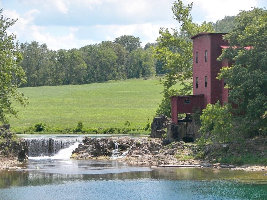
18. Dillard – Mill Pond Reflections and Red Barns

Dillard gathers around a historic mill and a sweep of pasture that glows at golden hour. Its secluded feel rides on two-lane approaches and forested knobs that fold the sound out of the air.
The vibe is postcard-rural: red barns, a clear mill pond, and a store where conversation lasts longer than the purchase. Tour the Dillard Mill State Historic Site, picnic along Huzzah Creek, hike forest trails, or hunt for morels in spring.
Small cattle outfits, mill tourism, and logging shape the calendar. Evenings bring whip-poor-wills and the low hush of water over stone. It’s the kind of quiet that lingers.
Where is Dillard?

Dillard sits in southeastern Crawford County along MO-49, about 20 miles south of Steelville. The highway narrows to curves between pine-clad hills as you near the mill.
Side roads turn to gravel quickly. It feels tucked in, like the hills drew the map around it.
17. Irondale – Rail Town with Big River Edges

Irondale is a small rail town where porches face the tracks and the Big River carves quiet bends nearby. Seclusion comes from being a step off US-67 and shielded by hills and timber, keeping most through-traffic away.
The mood is old-fashioned: depot memories, tidy lawns, and a café that knows your order. Fish the Big River, wander Irondale City Park, photograph iron-rich bluffs, or roll out to forest roads in the surrounding hills.
Light industry, commuting, and local shops keep things steady without much noise. At dusk, train horns tuck the day in. Irondale is a whisper with a timetable.
Where is Irondale?

Irondale sits in western Washington County, about 8 miles southwest of Potosi, reached from the MO-M off US-67. Once you leave the four-lane, the landscape closes in to trees and creek crossings.
Streets are short and quiet. It’s near the highway, yet it feels like you missed a turn on purpose.
16. Knob Lick – A Granite Dome Above the Pines

Knob Lick collects at the base of a granite prominence that catches first light and last, with scattered homes tucked among oaks and shortleaf pines. Its seclusion shows in the long views: ridges in every direction and little to suggest a hurry.
The vibe is outdoorsy and spare—fire towers, wild azalea thickets, and the clean scent of stone after rain. Climb to the Knob Lick lookout, roam nearby conservation areas, chase wildflower blooms, or explore pink-granite shut-ins a county over.
Timber work, small farms, and commuting to nearby towns fill the week. Nights come quickly as the hill squeezes the daylight out. Knob Lick makes the horizon feel personal.
Where is Knob Lick?

You’ll find it in southern St. Francois County, about 8 miles south of Farmington along US-67 and MO-Y.
A quick turn from the four-lane drops you into the woods and rock. Roads narrow and climb as you near the dome. It’s a short drive from town but a long way in mood.
15. Grubville – Big River Bends and Ridge-Top Farms

Grubville strings along ridge tops and bottoms near the Big River, a place of hay fields, cattle, and gravel drives that end in trees. Its solitude comes from distance to interstates and curving blacktop that locals know by heart.
The vibe is blue-jeans simple: farm dogs, smoke from a brush pile, and porch talk at sunset. Fish the river’s quiet pools, run gravel for wildflowers in spring, stop at a country store for a sandwich, or make a loop through nearby conservation areas.
Ranching, trades, and commuting set a slow, steady beat. After dark, the hills return every sound softly. Grubville is the quiet between breaths.
Where is Grubville?

Set in western Jefferson County near the Franklin County line, Grubville lies roughly 45 miles southwest of St. Louis. Approaches are via MO-Y, MO-NN, and county lanes that bend with the hollows.
There’s no straight shot, which keeps speeds low. It’s close enough for errands, far enough to hear the crickets.
14. St. Albans – River Bluffs and Private Lanes

St. Albans hides on high ground above the Missouri River, where private lanes and forested slopes keep it hushed. Seclusion stems from gated roads, steep bluffs, and a river valley that discourages shortcuts.
The mood is manicured but quiet—historic chapels, old brick, and oak shade thick as curtains. Walk the bluff-top lanes, visit the historic schoolhouse, ride the nearby Katy Trail, or watch fog lift off the river at first light.
Golf, hospitality, and heritage sites share space with deep woods. Even with the metro an hour away, night feels rural here. St. Albans is the hush on the edge of a map.
Where is St. Albans?

It sits in far eastern Franklin County, about 12 miles southwest of Wildwood and 40 miles west of downtown St. Louis. Reach it from MO-100 via St. Albans Road, a winding climb into the bluffs.
The river and hills shape every turn. It’s close to the suburbs yet feels like a river overlook no one else has found.
13. Treloar – Katy Trail Stop with an After-Hours Hush

🔥 Would you like to save this?
Treloar is a handful of storefronts tucked between vineyard hills and the old MKT line, now the Katy Trail. Its seclusion comes from the Missouri River bottoms on one side and folded bluffs on the other, funneling travel to a quiet two-lane.
The vibe is trail-casual: bikes leaning against clapboard, cicadas thrumming over soybeans, and long shadows on the platform as evening comes. Pedal the Katy east or west, sip wine at nearby hillsides, fish the backwaters, or watch harvest roll through the bottoms.
Farming and trail travelers keep the lights on, but nights are another story. After sunset, you can hear the river breathe. Treloar is a pause button you can park at.
Where is Treloar?

Treloar sits in southern Warren County along MO-94, about 14 miles west of Marthasville. The river road winds under bluffs with few passing zones, keeping traffic thin.
Trailheads and farm drives make up most turnoffs. It’s linear on the map, but timeless in person.
12. Rhineland – High-Ground Village Above the Floods

Rhineland is a resilient little village, moved to higher ground after the ’93 flood, now perched above the river it still calls home. Its seclusion is shaped by long, levee-lined fields and bluffs that keep horizons wide and streets quiet.
The mood is tidy and neighborly—flower boxes, church suppers, and tractors tracing slow lines in the distance. Walk the bluff-top streets, ride the Katy Trail below, taste local wines, or watch storms march upriver from a safe, dry porch.
Farming and small hospitality are the anchors. Even the wind sounds bigger out here. Rhineland is proof that calm can be rebuilt higher.
Where is Rhineland?

Find it in Montgomery County along MO-94, about 6 miles west of Hermann. The approach hugs the river, then climbs to the relocated townsite.
With the trail and fields below, there’s little through-traffic upstairs. It feels like a balcony over the valley.
11. Paynesville – Mississippi Bluffs and Empty Streets

Paynesville perches near the Mississippi River bluffs, where eagles ride the thermals and the streets stay quiet enough to hear them. Seclusion comes from being off the main Great River roadways and tucked among rolling fields and timber.
The vibe is spare and historic—old storefronts, weathered homes, and a town clock that seems content to jog instead of run. Watch for migrating raptors, photograph river overlooks, wander the old business row, or follow farm lanes that turn to gravel without apology.
Farming and a little antique trade keep the lights on. When evening settles, the big river keeps its voice low but steady. Paynesville is the kind of place that makes time behave.
Where is Paynesville?

Paynesville sits in northern Pike County, about 12 miles southeast of Clarksville and the Mississippi River’s broad bends. Access is via MO-79 and smaller county roads that climb and dip with the bluffs.
There’s no quick way through—only scenic ones. It’s close enough for a Saturday drive, far enough to feel like you left the calendar at home.
10. Caledonia – Tiny 19th-Century Village Tucked in the Washington County Hills

Home to roughly 150 residents, Caledonia invites slow strolls past century-old brick storefronts and an 1800s stone jail that now houses a quilt shop. Day-trippers hunt antiques, sip limeades at the one-block soda fountain, and wander the nearby Mark Twain National Forest for waterfall hikes along Crane Lake.
Small cow-calf operations and a seasonal farmers’ market supply most local income, while a pair of B&Bs cater to leaf-peepers each October. The village limits end almost as soon as they begin, bordered by rolling pastureland ringed with split-rail fences.
No stoplights, limited cell coverage, and whisper-quiet nights amplify the sense of stepping back a century. Its compact main street, wrapped in 40,000 acres of public forest, keeps modern bustle comfortably out of sight.
Where is Caledonia?

Caledonia sits on Highway 21 in southern Washington County, about 85 miles southwest of St. Louis. Heavily wooded ridges to the east and west block secondary routes, so the highway feels like the town’s single lifeline.
Travelers usually exit U.S. 67 at Farmington, then follow a winding 25-mile climb through oak stands and pastures. That last half-hour of two-lane silence is what preserves Caledonia’s rare calm.
9. Marquand – Ozark River Hamlet Hidden Along the Castor

Marquand’s population hovers near 200, yet its restored iron bridge, tiny depot museum, and stone sidewalks fill memory cards fast. Canoe launches on the spring-fed Castor River draw anglers hunting for smallmouth bass, and each September the town square hosts an apple festival complete with mule-team rides.
Sawmills and a family-run winery form the economic backbone, with weekend cabin rentals rounding out paychecks. Because the nearest four-lane road lies 20 miles away, locals joke that GPS signals arrive slower than the mail.
Towering sycamores, wooded bluffs, and the rhythmic hum of cicadas cushion the community in deep Ozark quiet. After dusk, porch lights replace streetlamps, underscoring how far removed the town is from neon glare.
Where is Marquand?

🔥 Would you like to save this?
Marquand hides in Madison County’s southeast corner, tucked between Highway 51 and the Castor River’s north fork. The hills here rise so steeply that radio reception fades once drivers leave Highway 67 near Fredericktown.
Access comes via state routes C or A—both two-lane ribbons that twist through forest and past charcoal kilns. Those curves discourage through-traffic, which explains why Marquand still feels hidden.
8. Sedgewickville – Bollinger County’s One-Stoplight Farm Crossroads

With fewer than 200 residents, Sedgewickville centers on a single blinking light where tractors and grain trucks meet. Sunrise reveals endless rows of corn and soy stretching toward forested ridges, while evenings often bring pickup-bed concerts outside the weathered feed store.
Family farming dominates the local ledger, supported by a small engine repair shop and two churches that share potluck duties. Gravel lanes peel off in every direction, disappearing into hollows rich with morels each spring.
That patchwork of cropland and timber forms a natural buffer against sprawl, making cell towers scarce and billboards nonexistent. The quiet only breaks for the low whistle of a red-tailed hawk circling freshly cut hay.
Where is Sedgewickville?

This crossroads lies 30 miles west of Jackson, reachable by State Route K after a climb across the Whitewater River valley. Surrounding hills and limited bridges mean detours are rare, so only locals and purpose-bound visitors pass through.
The nearest interstate sits nearly an hour away, reinforcing the rural hush. Anyone arriving after dark will notice the Milky Way long before they spot a streetlamp.
7. Brazeau – German Heritage Settlement on Perry County Wine Ridge

Barely 50 people call Brazeau home, yet its limestone Immanuel Lutheran Church, 1830s log cabins, and century-old mercantile store pack history into every footstep. Daytime brings cyclists tasting Norton grapes at Hemman Winery, while the evening hush invites photographers chasing fireflies over vineyard-dotted hills.
Agriculture—mostly grapes, cattle, and hay—fuels the sparse payroll, with seasonal tourism providing a gentle boost. Because no incorporated town lies within 15 miles, services are limited to a post office window and the winery’s weekend kitchen.
Rolling uplands flatten cell reception and muffle road noise, giving the hamlet a cloistered charm. Dense woodland to the north and Mississippi River bluffs to the east complete the seclusion.
Where is Brazeau?

The village rests on Perry County Road 446, four winding miles east of Highway C and roughly 12 miles from the Mississippi. Drivers typically exit I-55 at Perryville, then follow a labyrinth of lettered routes through cornfields and wine country.
That final stretch narrows to a lane and a half, encouraging slow speeds and scenic pauses. Once there, visitors realize the road they came on is also the quickest way out.
6. Cherryville – Crawford County Outpost Guarded by Pine-Clad Knobs

Cherryville’s scattering of homes and two businesses support perhaps 300 residents spread across broad, wooded lots. Adventurers base here for horseback loops on the Ozark Trail and secluded swimming holes along Huzzah Creek six miles west.
Logging and small cattle herds provide most year-round work, punctuated by seasonal outfitters renting kayaks to summer floaters. State Route 19 bisects town, yet average traffic is light enough that kids still ride bicycles down the centerline.
Dense stands of shortleaf pine absorb road noise, and no commercial chain has ever set up shop. That evergreen curtain, paired with minimal street lighting, seals Cherryville in a pocket of back-country peace.
Where is Cherryville?

Find Cherryville 35 miles south of Cuba, Missouri, along State Route 19 where the pavement begins to wrinkle into Ozark folds. The Mark Twain National Forest hems the hamlet on three sides, leaving only the highway for quick access.
Drivers coming from St. Louis exit I-44, then spend nearly an hour on curvy asphalt that climbs through hollows and across ridge tops. Those switchbacks do more than test brakes—they filter out hurried travelers.
5. Bixby – Storefront-Size Community on Scenic Highway 32

Fewer than 100 year-round residents share Bixby’s lone general store, two rustic rental cabins, and a decommissioned schoolhouse now used for bluegrass jams. Highway 32 ushers motorcyclists to sweeping overlooks, but most pause here for the homemade jerky and a chat about local turkey numbers.
Forestry, hunting leases, and a portable sawmill anchor the modest economy, with autumn leaf traffic providing a welcome bump. Surrounding oak and hickory forests remain largely uncut, so sightlines vanish quickly into green walls that hush the highway.
Nighttime reveals frog choruses rising from hidden ponds, confirming the deep-woods setting. With no town square, stoplight, or cellular tower, Bixby feels like a frontier waystation left intact.
Where is Bixby?

Bixby marks the midpoint between Salem and Lesterville, sitting at the junction of Highways 32 and 49. Those two scenic byways snake across the Courtois Hills, discouraging tractor-trailers and keeping noise low.
Visitors from Rolla or St. Louis usually take Highway 72 to reach this ridge-top crossroads. Once there, the only directional question is whether to turn right for views or left for river gravel bars.
4. Lesterville – River Retreat Where the Black Forks Meet

Lesterville counts about 600 full-time residents who occupy multi-acre lots fringed by towering pines and rocky riverbanks. Summer brings flotillas of canoes and tubes drifting the crystal-clear Black River forks, while off-season months replace crowds with eagle-watching solitude.
Outfitters, cabin resorts, and a handful of cafes drive the local ledger, complemented by small cattle ranches on the town’s outskirts. No chain franchises mar the view; instead, hand-painted signs guide travelers to homemade fudge or spring-fed swimming holes.
The steep valley walls act as natural amphitheaters, reflecting water sounds and muting road noise. After campfires die down, darkness settles so thick that the Milky Way looks close enough to touch.
Where is Lesterville?

Nestled in Reynolds County, Lesterville sits where Highways 21 and 49 meet, about 40 miles south of Arcadia. Forest-cloaked mountains hem the town, leaving only two paved routes in or out.
The closest commercial airport is two hours away, ensuring that most visitors arrive by winding state roads. Those curves, plus an absence of streetlights for the last ten miles, keep the river valley remarkably hushed.
3. Frohna – Quilt-Pattern Farms in Perry County’s Rolling Uplands

Frohna’s population hovers below 300, yet its white Lutheran steeples, brick conservatory, and Saxon Lutheran Memorial log cabins offer an architectural timeline spanning 180 years.
Visitors admire patchwork vistas of wheat, alfalfa, and hay divided by hedgerows—a scene that inspired the town’s annual outdoor quilt show. Row-crop farming and a cooperative dairy anchor the economy, with a microbrewery in a converted barn tapping Friday-night crowds.
Traffic remains so light that combine harvesters often roll down State Route F unhurried. The absence of billboards, paired with endless farm horizons, creates a calm rarely found east of the Mississippi. Sunset ignites ridge-top fields in amber, punctuating the sense of open-air freedom.
Where is Frohna?

The village lies ten miles south of Perryville, reached by County Road 444 after exiting I-55.
Limestone bluffs along Apple Creek funnel drivers into a single valley, making detours impossible and preserving the area’s quiet charm. St. Louis visitors need just under two hours, yet many remark how the final fifteen minutes feel like a different century. That narrowing approach is Frohna’s best defense against sprawl.
2. Patterson – Wayne County Hollow Surrounded by Ozark Foothills

Roughly 250 people live around Patterson’s historic stone Methodist church, where Sunday potlucks double as town meetings. Photographers set alarms for misty sunrises that drift over the hollow, catching first light on dew-slicked pasture and clapboard porches.
Timber cutting and seasonal hunting camps pay most bills, supplemented by a small sawmill just outside town. Only a two-lane blacktop slices through, and the nearest gas pump sits eight miles away, leaving nights so silent that barred owls echo off the foothills.
Steep, tree-blanketed ridges encircle the community, enforcing an amphitheater of solitude. Locals measure time not by clocks but by bloom cycles of dogwood and redbud.
Where is Patterson?

Patterson rests along Highway 34, 12 miles west of Piedmont and 95 miles south of Cape Girardeau. The surrounding foothills create a natural bowl that blocks cell and radio signals alike.
Travelers reach the hollow via a series of tight S-curves that climb over Clark Mountain before dropping steeply into town. That topography discourages hurried traffic, ensuring tranquility endures.
1. Defiance – Missouri River Bottomland Village Beyond the Vineyards

Though best known as a waypoint on the Katy Trail, Defiance counts fewer than 200 full-time residents spread across bluff-top acreages. Cyclists pause for craft beer at the century-old tavern, then roll past pioneer cemeteries hidden among riverbank cottonwoods.
Local paychecks come from family wineries, a blacksmith shop catering to equestrians, and seasonal trail tourism. Yet step a block from Main Street and gravel lanes weave into dense woodland and marshy river backwaters where great blue herons fish in silence.
Limestone bluffs to the south and Missouri River wetlands to the north wrap the hamlet in a natural buffer. As twilight settles, only the hush of crickets and distant barge horns mark the hours.
Where is Defiance?

Defiance sits in southern St. Charles County along Highway 94, about 35 miles west of downtown St. Louis. The road hugs the Missouri River and weaves through vineyard-studded hills, limiting expansion and filtering traffic to local explorers and Katy Trail riders.
Access mainly comes via I-64 to Route 94, a scenic drive that narrows to one lane each way with no shoulders. Those constraints shield Defiance from suburban creep, letting the village remain a pocket of calm on the metro’s farthest edge.


