🔥 Would you like to save this?
I love nothing more than hopping in the car, rolling down the windows, and letting Arizona’s vast desert horizons unfurl mile after mile in front of me. Scenic drives in this state feel like paging through a living travel atlas, each bend revealing another small town that tells its own colorful story.
On every trip, I’m reminded that Arizona’s real magic is often found between the big destinations—inside cafés converted from mining shacks, along boardwalks echoing with Old West lore, or at trailheads that start right on Main Street.
In order to come up with the very specific design ideas, we create most designs with the assistance of state-of-the-art AI interior design software.
The seventeen towns below have become my favorite mile markers for road-trip daydreamers who crave history, community, and panoramic beauty in equal measure. If you’re itching to steer off the interstate and string together a drive you’ll talk about for years, let me show you where I always slow down.
17. Jerome: The Ghost Town Turned Artist Haven Perched on a Mountainside

Jerome clings to Cleopatra Hill like a patchwork of weathered wooden decks and brightly painted galleries, and I never tire of watching the sun set over the Verde Valley from its switchback streets.
Once one of the richest copper camps in the world, the town collapsed into near abandonment before artists began reviving the crumbling buildings in the 1960s. Today, you can browse studios carved into former saloons, sip cabernet at Caduceus Cellars, and hunt for local legends on a Jerome Ghost Walk after dark.
The sliding jail, which literally inched downhill over the decades, is a quirky photo stop that many first-timers miss. Drive a bit farther up the hill and you’ll find the Jerome State Historic Park housed in the old Douglas Mansion, where mining displays meet sweeping valley views.
Every hairpin curve on the ascent feels like an invitation to slow down and let the past whisper through the open windows. The average price for a 3-4 bedroom home in Jerome ranges from $400,000 to $600,000, offering a unique opportunity for those looking to live in a historic, scenic town.
Where is Jerome?

Jerome sits in central Arizona, about 100 miles north of Phoenix and high above Cottonwood on State Route 89A. Its perch at roughly 5,000 feet provides cooler temperatures and a commanding panorama of the Verde Valley’s patchwork of vineyards and desert scrub.
From Phoenix, I like to take I-17 north to Camp Verde, then wind west along 260 and 89A—an hourglass-shaped route that passes cliff dwellings and fragrant juniper forests. The tight mountain road up Cleopatra Hill is narrow but paved, making the climb as memorable as the destination.
16. Bisbee: The Quaint Mining Town Nestled in the Mule Mountains

Bisbee feels like a Mediterranean hill village inexplicably dropped into southern Arizona, its pastel Victorian homes stacked above narrow alleys that invite casual wandering.
I always begin at the Copper Queen Mine Tour, donning a hard hat and trundling deep into tunnels that once pulsed with industry. Back on the surface, Main Street bursts with bookstores, vintage boutiques, and cafés serving locally roasted coffee strong enough to fuel the uphill walks.
The Bisbee 1000 Stair Climb—literally a race up the town’s connected staircases—shows just how vertical daily life can be here. A hidden gem I treasure is the Muheim Heritage House Museum, where porch chairs offer one of the best sunset vantage points over Brewery Gulch.
At night, the trouble of parking on a steep street is rewarded by a sky so clear it seems stitched with sequins. 3-4 bedroom homes in Bisbee are typically priced between $250,000 and $400,000, providing a mix of affordability and charm in this artsy desert town.
Where is Bisbee?

You’ll find Bisbee about 90 miles southeast of Tucson, tucked into the Mule Mountains at 5,500 feet. Its bowl-shaped geography shields it from desert winds and lends every balcony an amphitheater view of red-soiled peaks.
Drivers usually follow AZ-80 south from Benson, a byway that parallels the old rail line and slides through tunnels before revealing Bisbee in a sudden flourish of rooftops.
15. Cottonwood: The Heart of Arizona’s Wine Country

Cottonwood sits at the center of the Verde Valley, and I’ve come to think of it as Arizona’s most relaxed tasting room. Old Town’s brick storefronts house more than a dozen wineries where you can sample grenache one minute and walk to a craft-beer taproom the next.
Beyond the swirl-and-sip scene, the Dead Horse Ranch State Park offers shaded trails along the Verde River where great blue herons glide over cottonwood leaves that actually shimmer silver in the breeze.
I never skip dinner at Pizzeria Bocce, where the patio lights flicker beneath the same trees that inspired the town’s name. An underrated stop is Tuzigoot National Monument, an ancient hilltop pueblo just a couple of miles away that rewards a short climb with 360-degree desert views.
All of this is stitched together by the gentle curves of AZ-89A, which makes Cottonwood an essential anchor for any red-rock road trip. In Cottonwood, 3-4 bedroom homes range from $350,000 to $500,000, offering a variety of options for those looking to experience this scenic location with a rich history.
Where is Cottonwood?

The town lies roughly halfway between Prescott and Sedona along the Verde River, placing it at 3,300 feet amid rolling desert and fertile riparian zones. That blend of rocky hillsides and river soil explains why grapes flourish here, creating a patchwork of vineyards you can spot from the highway.
Most visitors arrive via AZ-260 or the scenic 89A, both of which slice through juniper-studded high desert and make the first sip of chilled viognier feel well earned.
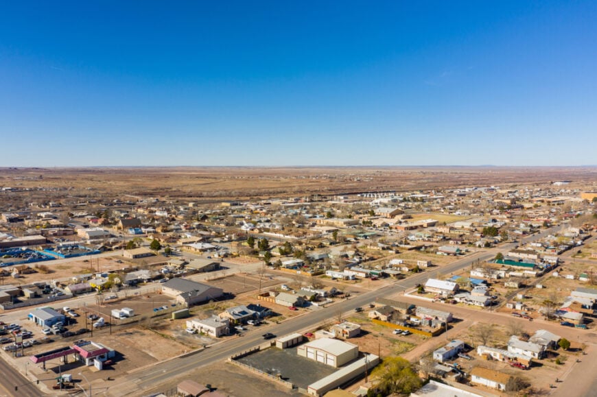
14. Williams: The Route 66 Town Gateway to the Grand Canyon

Williams embraces its Mother Road heritage with neon signs, classic diners, and even nightly gunfight reenactments that make me grin every time a “bad guy” tumbles onto the asphalt.
The town’s other claim to fame is the Grand Canyon Railway, whose vintage cars whistle north through ponderosa forests, delivering passengers to the canyon’s South Rim without needing to navigate parking chaos.
I enjoy starting the morning at Pine Country Restaurant for a slice of pie, then driving the loop around Bearizona Wildlife Park, where bison and wolves roam just beyond my rolled-up window.
Evening brings cooler air, perfect for strolling the brick sidewalks and browsing souvenir shops stocked with kitschy Route 66 memorabilia. A lesser-known treat is Cataract Lake’s easy shoreline trail, where I’ve watched osprey plunge for fish against a backdrop of distant cinder cones.
Williams reminds me that nostalgia and natural wonder can coexist on one small stretch of highway. 3-4 bedroom homes in Williams are priced between $350,000 and $500,000, making it an attractive option for those drawn to its historic downtown and proximity to the Grand Canyon.
Where is Williams?
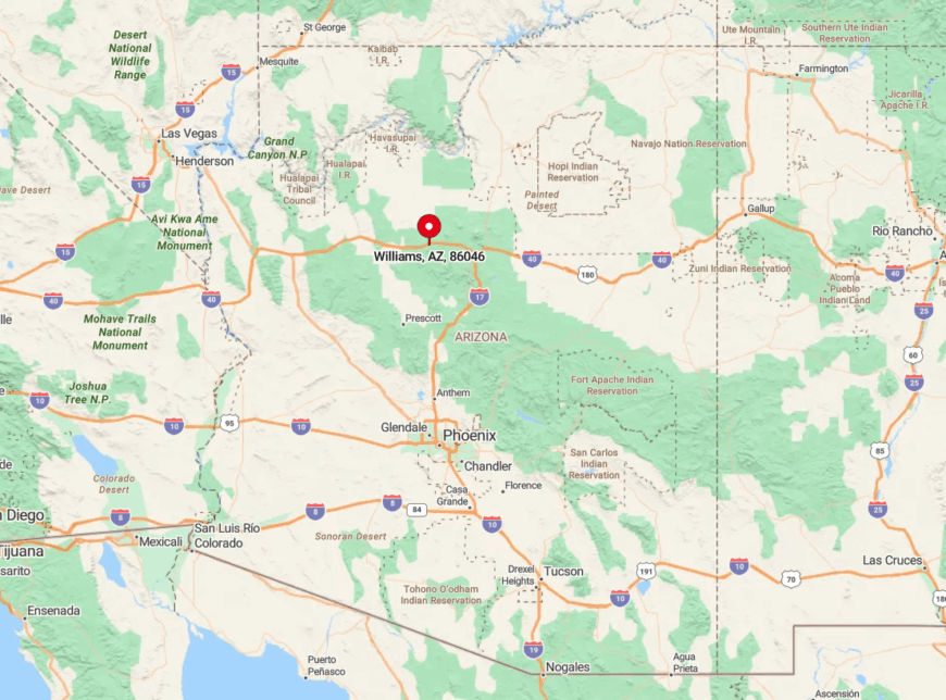
Sitting at 6,770 feet on the Kaibab Plateau, Williams is 30 miles west of Flagstaff along I-40 and historic Route 66. The high elevation means tall pines soften the desert’s harshness, making summer evenings refreshingly cool.
Drivers from Phoenix typically climb I-17 to Flagstaff before angling west, while Canyon-bound travelers often park in Williams and hop on the train for a car-free adventure. The detour south on Perkinsville Road rewards those with clearance and patience, revealing sweeping vistas of Sycamore Canyon few tourists ever see.
13. Globe: Rich Mining Heritage Amidst Rugged Desert Landscapes

Globe wears its history proudly, from the Gila County Courthouse’s stately columns to the century-old neon of the Drift Inn Saloon, where I’ve traded canyon stories with friendly locals over green-chile burgers.
The Besh-Ba-Gowah Archaeological Park shelters a 700-year-old Salado pueblo where pottery shards still peek from the soil, linking the town’s mining narrative to a deeper Indigenous past.
I like to follow that cultural deep dive with a scenic drive along Round Mountain Road, which climbs above Globe for a panorama that stretches clear to the Superstition Mountains.
Antique hunters should duck into Pickle Barrel Trading Post, a sprawling warehouse of turquoise, spurs, and unexpected curios. For a quick nature fix, the Pinal Mountains just south of town offer shady hikes that smell of pine and wet granite after a summer monsoon.
Every corner of Globe feels etched by the pickaxes and stories of those who carved a life from this rugged bowl of rock. The average price for a 3-4 bedroom home in Globe is between $200,000 and $300,000, providing affordable options for those seeking a small-town desert escape.
Where is Globe?

Located 90 minutes east of Phoenix at the junction of US-60 and AZ-77, Globe nestles in a sandstone valley at 3,500 feet. Its spot at the transition zone between the Sonoran Desert and the pine-topped Pinals gives road-trippers a striking change of scenery within just a few miles.
Most visitors approach via the dramatic Queen Creek Tunnel on US-60, a route that winds through volcanic cliffs and makes the first glimpse of Globe’s copper-colored rooftops feel cinematic.
If you have time, continue east toward Salt River Canyon, often called a “mini Grand Canyon,” for switchbacks that rival any amusement-park ride.
12. Patagonia: The Lush Oasis for Nature Lovers

When desert heat presses down on Tucson, I steer south to Patagonia, where cottonwoods line Sonoita Creek and birdcalls replace city sirens. The Patagonia-Sonoita Creek Preserve is a birder’s dream—I’ve spotted vermilion flycatchers and once glimpsed a rare elegant trogon on an early spring morning.
Art galleries and cafés cluster around the tiny main intersection, fueling post-hike appetites with homemade pastries and locally roasted coffee. A favorite hidden gem is the tiny Paton Center for Hummingbirds, where dozens of iridescent visitors buzz mere inches from camera lenses.
For a broader view, I drive Harshaw Road through rolling grasslands backed by the Santa Rita Mountains, a scene that feels more Montana than Arizona. Patagonia’s gentle green corridor proves that deserts can bloom with life when water is cherished.
In Patagonia, 3-4 bedroom homes are typically priced between $250,000 and $350,000, offering a quaint option for those drawn to its natural beauty and artistic community.
Where is Patagonia?

The town rests at 4,050 feet in Santa Cruz County, about 18 miles north of the Mexican border along AZ-82. Its valley location captures runoff from surrounding peaks, creating a ribbon of verdant habitat rare in southern Arizona.
From Tucson, the hour-long drive south on I-10 and AZ-83 crosses oak-dotted hills before dropping into Sonoita’s wine country and finally Patagonia’s leafy embrace. If you push on another 10 miles, AZ-82 threads through the ghost town of Harshaw, adding historic ruins to an already scenic detour.
11. Tubac: Artistic Enclave with Spanish Colonial Roots

🔥 Would you like to save this?
Tubac’s adobe walls glow honey-gold in late afternoon, and each time I wander its pedestrian lanes, I discover a new studio tucked behind blooming bougainvillea. Established in 1752 as Spain’s first European settlement in Arizona, the town now hosts more than 100 galleries.
I like to start at Tubac Presidio State Historic Park, where a short film explains how soldiers, missionaries, and Indigenous peoples shaped this stretch of the Santa Cruz River. The Anza Trail slices right through town, offering a shady stroll toward cottonwood stands where great-tailed grackles chatter overhead.
Don’t miss Elvira’s Restaurant for chile en nogada under a ceiling dripping with hand-blown glass lamps—truly a feast for both palate and eyes. Tubac proves that centuries-old walls can still pulse with creative energy.
3-4 bedroom homes in Tubac range from $350,000 to $550,000, reflecting the town’s appeal for those seeking a blend of history, art, and scenic desert surroundings.
Where is Tubac?

You’ll find Tubac 45 miles south of Tucson just off I-19, resting at 3,200 feet beside the Santa Cruz River. The river’s intermittent flow nourishes a green ribbon that contrasts sharply with the surrounding mesquite desert, making roadside cottonwoods a welcome sight for travelers.
Most folks exit I-19 at mile 34 and roll into town within minutes, though I prefer the slower East Frontage Road that parallels the highway and passes mission ruins at Tumacácori. From Tubac, continuing south to Nogales offers a seamless extension into borderland culture and cuisine.
10. Wickenburg: The Cowboy Capital Steeped in Western Tradition

Wickenburg greets visitors with bronze horse statues on Frontier Street, and it doesn’t take long before I catch the scent of leather from boot shops lining the sidewalks.
The Desert Caballeros Western Museum showcases saddles, spurs, and dazzling cowboy art that brings the area’s ranching legacy to life. For a taste of the trail, I book a horseback ride at the historic Flying E Ranch, where saguaros frame endless desert horizons that blush pink at dusk.
Downtown’s Jail Tree—a 200-year-old mesquite once used to chain rowdy outlaws—makes for an entertaining history lesson in under five minutes. Hidden just east of town, Vulture City Ghost Town preserves weather-worn mining structures and a chilling “Hanging Tree” that will give you goosebumps on a hot day.
Every drive into Wickenburg along US-60 feels like galloping straight into a sepia-toned postcard. For those interested in Wickenburg, 3-4 bedroom homes are priced between $300,000 and $450,000, offering a variety of options for those seeking life in a charming western town.
Where is Wickenburg?

Situated 60 miles northwest of Phoenix, where the Sonoran Desert meets the Hassayampa River, Wickenburg sits at 2,100 feet with mesas rising like guardians on all sides. Its location at the crossroads of US-60 and US-93 makes it a natural pit stop for travelers bound for Las Vegas or the Grand Canyon.
I typically take the Carefree Highway (AZ-74) from the Phoenix metro, a saguaro-lined route that feels wilder than its name suggests. If you’re craving more scenery, loop north on AZ-89 toward Yarnell Hill for panoramic pullouts that reveal the desert floor stretching endlessly south.
9. Greer: The Alpine Hamlet in Arizona’s White Mountains

Greer feels worlds away from the saguaro desert, its log cabins tucked among aspen groves that quake silver and gold in autumn breezes. At 8,500 feet, summer temperatures rarely top 80 degrees, so I spend afternoons fly-fishing in the sparkling Little Colorado River .
A favorite trail of mine, the West Baldy Trail, climbs through wildflower meadows to 11,000-foot vistas that leave me speechless (and a little breathless). After a day on the slopes at nearby Sunrise Park Resort in winter, Molly Butler Lodge serves elk burgers beside a stone fireplace that crackles well past bedtime.
For a quieter treat, I wake early to watch sunrise from Butler Peak Road, where the first light sets distant peaks ablaze while the valley still slumbers. Greer proves Arizona can do alpine serenity just as well as desert drama.
3-4 bedroom homes in Greer are typically priced between $350,000 and $500,000, offering a picturesque setting for those looking to live in a serene mountain town.
Where is Greer?

The village hides in the upper reaches of the Little Colorado River Valley, about 15 miles east of AZ-260 in Apache County. Encircled by the Apache-Sitgreaves National Forest at nearly 9,000 feet, it claims some of the state’s coolest summer nights.
Most travelers reach Greer by turning south at Eagar onto AZ-373, a two-lane road that tunnels through dense spruce before suddenly revealing meadow-ringed cabins. Those coming from Phoenix should expect a four-hour journey that rises more than a mile in elevation, a climb that feels like trading cacti for Christmas trees.
8. Pine: Rustic Charm Along the Mogollon Rim

Pine smells of ponderosa bark—sweet, almost vanilla—and every visit tempts me to stay longer than planned. The small downtown hosts craft shops, a meadery pouring prickly-pear honey wine, and the Strawberry-Pine Historical Museum set in a 19th-century schoolhouse.
I always hike the Pine Canyon Trail, where travertine springs feed fern-lined pools, an unexpected oasis beneath towering rim cliffs. For a quirky side quest, the Tonto Natural Bridge near neighboring Payson reveals the world’s largest travertine arch, its cavernous tunnel echoing with waterfalls after monsoon rains.
Pine’s blend of rustic cabins and cliffside drama makes it a refreshing punctuation mark on any rim-hugging road trip. In Pine, 3-4 bedroom homes range from $350,000 to $500,000, making it an ideal location for those who enjoy the beauty of nature in a small, tranquil community.
Where is Pine?

Pine perches at 5,400 feet just off AZ-87, about a two-hour drive northeast of Phoenix through the ever-steepening Mazatzal Mountains. Its proximity to the Mogollon Rim means you can stand on Highway 87 turnouts and gaze 2,000 feet down onto the desert you left behind that morning.
From Phoenix, the Beeline Highway (AZ-87) offers sweeping curves and frequent elk sightings, delivering you to Pine’s welcome sign before you realize how far you’ve climbed. Continuing north, the highway hugs the Rim toward Winslow, turning a simple drive into an elevated tour of Arizona’s geological backbone.
7. Superior: The Desert Town with a Botanical Treasure

Superior may be small, but it commands attention thanks to craggy Apache Leap towering above and the Boyce Thompson Arboretum blooming just west of town. I start every visit with a stroll through the arboretum’s 3.5-mile trail network, where Australian eucalyptus groves meet cactus gardens.
Downtown, colorful murals celebrate mining roots while new cafés serve cold brew to hikers heading for the Queen Creek Trail, a canyon walled with chocolate-brown volcanic rock.
The town’s annual Prickly Pear Festival introduces inventive treats like cactus-fruit gelato that’s both tart and sunset-pink. For history buffs, the Magma Hotel’s lovingly restored rooms showcase century-old brickwork that once hosted miners flush with newly earned pay.
Superior stands as proof that gritty mining heritage and delicate desert blooms can share the same address. 3-4 bedroom homes in Superior are priced between $200,000 and $300,000, providing a cost-effective option for families looking to settle in this historic mining town.
Where is Superior?

Perched at 2,888 feet along US-60, Superior lies 70 miles east of Phoenix and 25 miles west of Globe. Its location at the base of the Pinal Mountains and on the lip of Queen Creek Canyon makes the surrounding geology feel almost theatrical.
Most drivers reach it via the Gonzales Pass stretch of US-60, a corridor of hoodoos and sweeping S-curves that beg for roadside photo stops. An alternate, slower route from Mesa along the Apache Trail (when open) offers dramatic vistas of Canyon Lake before looping south toward town.
6. Show Low: High-Country Town with a Legendary Origin

Show Low’s name supposedly comes from an 1870s poker game in which the low card won a ranch—if you “show low,” you take it all. Today, the town retains that playful spirit with annual events like Show Low Days, where lumberjack contests and hot-air balloons share the schedule.
I’m fond of renting a kayak on Fool Hollow Lake, whose mirrored surface often reflects passing monsoon clouds like a living watercolor. Cyclists flock to the Tour of the White Mountains each fall, pedaling through ponderosa stands that smell of butterscotch in the sun.
Whether you come for lore or lake breezes, Show Low makes a fun base for exploring the surrounding high country. The average price for a 3-4 bedroom home in Show Low is between $300,000 and $450,000, reflecting the town’s popularity as a gateway to the White Mountains.
Where is Show Low?

The town anchors Arizona’s Mountain Plateau at 6,300 feet, where US-60 intersects AZ-260 roughly three hours northeast of Phoenix. This crossroads location means alpine forests radiate in all directions, offering quick escapes to Sunrise Ski Resort or the Mogollon Rim.
Phoenix travelers typically climb the Salt River Canyon on US-60, a dramatic descent and ascent that rivals the canyon’s famous cousin in grandeur. If you’re headed east, US-60 continues toward New Mexico, unfolding lonely grasslands perfect for stargazing stops.
5. Winslow: A Historic Stop on Route 66

🔥 Would you like to save this?
I can’t roll into Winslow without humming the Eagles’ lyric about “standin’ on a corner,” and the town obliges with a bronze statue and vintage flatbed Ford parked permanently for photo ops.
Beyond that famous corner, La Posada Hotel—Mary Colter’s 1930 masterpiece—welcomes guests with hand-painted murals and gardens scented with Russian sage. I often detour to Homolovi State Park, where ancient Hopi pueblos and wide-open skies offer solitude just a few miles north of town.
On summer evenings, locals gather at Snowdrift Art Space for pop-up exhibits inside a renovated 1920s car dealership, a creative spark that surprises many Route 66 pilgrims. Turquoise Room’s signature “Fred Harvey French Toast” turns breakfast into culinary nostalgia, blending historic dining-car recipes with modern flair.
Winslow demonstrates that a single song lyric can keep a town’s heartbeat steady for decades. 3-4 bedroom homes in Winslow typically cost between $150,000 and $250,000, making it an affordable choice for those looking to explore Arizona’s Route 66 charm.
Where is Winslow?

Winslow sits at 4,850 feet along I-40 in northern Arizona, about an hour east of Flagstaff on the original alignment of Route 66. The flat expanse of the Little Colorado River Plateau surrounds it, allowing sunrise and sunset to paint the sky unobstructed for 360 degrees.
Most travelers approach via I-40, though I enjoy the slower, more sentimental cruise along the parallel stretch of remaining Route 66 frontage road. From town, AZ-87 heads north toward the Painted Desert, turning a pit stop into a technicolor side adventure.
4. Clarkdale: Vintage Charm and Scenic Railways

Clarkdale sprang to life as a smelter town, yet its tidy brick homes and shaded parks feel unexpectedly genteel against the desert backdrop. The Verde Canyon Railroad departs from here, and I can never resist settling into an open-air car to watch bald eagles nest along red-rock cliffs while the locomotive hugs the riverbank.
Mingus Union High School’s Auditorium, an Art Deco gem built in 1939, hosts community theater that rivals big-city productions for enthusiasm and ticket-stub value.
For a sip with a view, I swing by Chateau Tumbleweed’s hilltop tasting room, where cottonwood-lined river bends unfurl beneath the patio. Nearby Tuzigoot’s sister ruin, the seldom-visited Bridgeport Pueblo site, lies hidden behind a locked gate that rangers will often open if you ask nicely.
Clarkdale pairs small-town calm with rail-side romance in a way that keeps me coming back. In Clarkdale, 3-4 bedroom homes are priced between $300,000 and $450,000, providing a mix of historical appeal and scenic views for prospective homeowners.
Where is Clarkdale?

The town hugs the Verde River below Jerome, about 25 miles southwest of Sedona via AZ-89A. Its lower elevation of 3,500 feet means warmer winters, making it a year-round base for Verde Valley exploration.
Drivers can reach Clarkdale from Phoenix via I-17 and AZ-260, then follow signs through Cottonwood’s historic district into town. Continuing north on 89A to Sedona transforms the landscape from river oasis to red-rock cathedral in under 30 minutes.
3. Page: Red Rock Vistas and Lake Powell Adventures

Page sprang up in the 1950s to house builders of Glen Canyon Dam, yet today it thrives on photo-hungry travelers chasing the perfect bend in the river. Antelope Canyon’s sculpted sandstone corridors, lit by swirling shafts of sunlight, feel like walking through a dream rendered in orange silk.
After the crowds thin, I rent a paddleboard on Lake Powell to glide into labyrinthine coves where water meets towering buttes in hushed reverence. A lesser-known treat is Alstrom Point, an off-road overlook that delivers sunrise views so vast they seem stitched from multiple worlds.
Page is the kind of place where your camera battery dies before your sense of wonder does. The average price for a 3-4 bedroom home in Page ranges from $300,000 to $500,000, offering access to stunning landscapes and outdoor adventures.
Where is Page?

Nestled on a mesa at 4,300 feet near the Utah border, Page sits along US-89 in Arizona’s far north. The surrounding Glen Canyon National Recreation Area creates a maze of water and stone that makes maps look like abstract art.
Most visitors drive north from Flagstaff on US-89, a two-hour journey past volcanic fields and pastel badlands that feels like a time-lapse of Earth’s geologic history. From Page, the short hop over the state line to Grand Staircase-Escalante National Monument turns one spectacular base camp into two.
2. Camp Verde: Where History and Nature Meet

Camp Verde rests beside the Verde River, its cottonwood canopy shading centuries of human stories from ancient Sinagua cliff dwellers to cavalry troops at Fort Verde. I love starting the day at Montezuma Castle National Monument, where a five-story cliff dwelling peers out from a limestone recess like an ancient high-rise apartment.
Fort Verde State Historic Park’s costumed interpreters bring frontier life alive, and a short drive east leads to Out of Africa Wildlife Park, where safari trucks rumble past giraffes that might steal your snack. A hidden gem is the Wingfield Bread Company on Main Street, where hearth-baked loaves fuel kayaking runs down the Verde River.
Camp Verde’s layered past and riverside playgrounds make it a natural pause on any central-Arizona loop. 3-4 bedroom homes in Camp Verde are priced between $300,000 and $450,000, making it an attractive option for those seeking a quiet, scenic place to call home.
Where is Camp Verde?

The town occupies a fertile valley at 3,100 feet where I-17 meets AZ-260, roughly 90 miles north of Phoenix. Its spot along the free-flowing Verde River nurtures farms, vineyards, and some of the state’s best birding riparian habitat.
Most travelers zoom past on I-17, but exiting at Finnie Flat Road rewards you with a five-minute detour into a historic downtown clustered with shaded porches. From Camp Verde, the winding Fossil Creek Road leads to turquoise swimming holes that feel like a secret Caribbean tucked inside red-rock country.
1. Holbrook: Gateway to the Petrified Forest

Holbrook greets travelers with dinosaur statues and wigwam-shaped motel rooms, a playful nod to Route 66’s golden era that never fails to make me smile. The town’s Old West roots run deep—just peek into the historic courthouse where the “Bucket of Blood” saloon once gave deputies plenty of overtime.
I always fuel up at Romo’s Café with a plate of green-chile enchiladas before cruising east to Petrified Forest National Park, where 200-million-year-old rainbow logs sparkle in the desert sun.
Back in town, the Navajo County Historical Museum’s basement jail cells offer a chilly reminder of frontier justice, while Jim Gray’s Petrified Wood Company hides a labyrinthine showroom of polished stone beyond the tourist trinkets.
3-4 bedroom homes in Holbrook generally cost between $150,000 and $250,000, providing a budget-friendly option for those wanting to experience life along the historic Route 66.
Where is Holbrook?

🔥 Would you like to save this?
Holbrook sits at 5,080 feet along I-40 in northeastern Arizona, roughly halfway between Flagstaff and the New Mexico border. The town straddles the floodplain of the Little Colorado River, making it a natural waypoint for ancient trade routes and modern asphalt alike.
Drivers from Phoenix can reach Holbrook in about three hours via I-17 and AZ-87, a route that crosses the dramatic Mogollon Rim before easing onto high desert grasslands.
From Holbrook, US-180 slices south through pastel badlands toward the Painted Desert’s southern entrance, putting petrified wonders just 20 minutes beyond the motel neon.


