🔥 Would you like to save this?
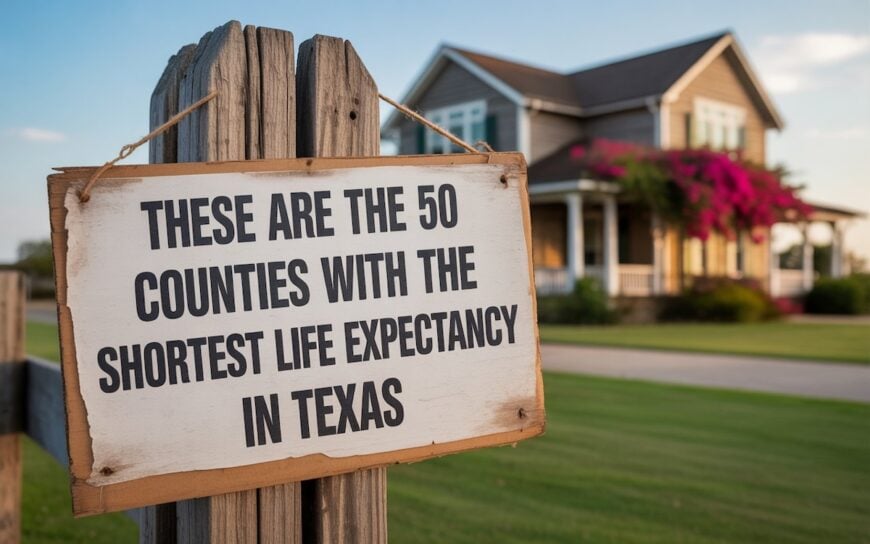
Counties with the shortest life expectancy in Texas
Life expectancy can be affected by a variety of factors. About 25% of your lifespan is determined by genetics, according to the National Library of Medicine. Health and wellness habits—like following a balanced, nutrient-rich diet; not smoking; drinking minimal alcohol; maintaining a healthy weight; and staying physically active—can add more than a decade to your life, research from the National Institutes of Health shows. While these factors are significant, another important element that you might not have considered is your environment and community.
In order to come up with the very specific design ideas, we create most designs with the assistance of state-of-the-art AI interior design software. Also, assume links that take you off the site are affiliate links such as links to Amazon. this means we may earn a commission if you buy something.
While life expectancy generally increases annually in the United States—jumping from about 70.8 years old to 77.5 between 1970 and 2022, according to the Centers for Disease Control and Prevention—this particular metric can vary from state to state or even county to county. In some parts of the country, the average lifespan is getting shorter based on a variety of risk factors on top of health, including socioeconomic factors like poverty, unemployment, income, and education.
According to a 2020 study from researchers at Penn State, West Virginia, and Michigan State Universities, communities with a higher population density, more fast food restaurants, and a high number of extraction industry-based jobs tend to have shorter life expectancies.
To find out how life expectancy varies within Texas, Stacker used 2024 County Health Rankings & Roadmaps from the University of Wisconsin Population Health Institute to identify the counties with the shortest life expectancy. Life expectancy measures the average number of years from birth a person can expect to live and is calculated based on the number of deaths in a given time period and the average number of people at risk of dying during that period. Counties with unreliable or insufficient data were excluded from the analysis. Mortality data came from the National Vital Statistics System.
Read on to see if your county is on the list.
You may also like: Counties with the highest STI rates in Texas

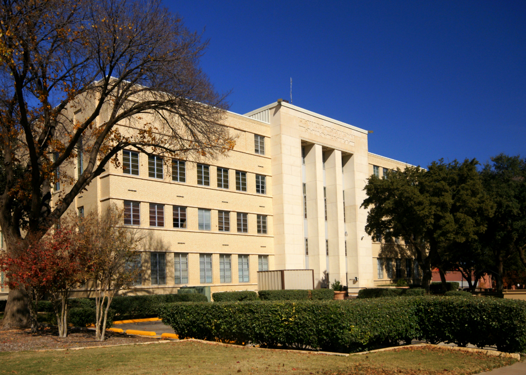
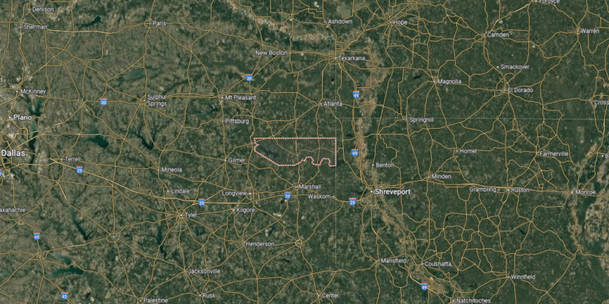
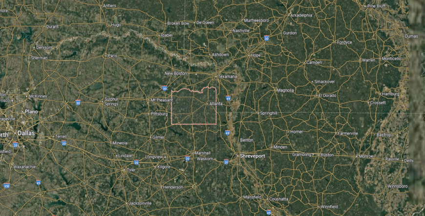
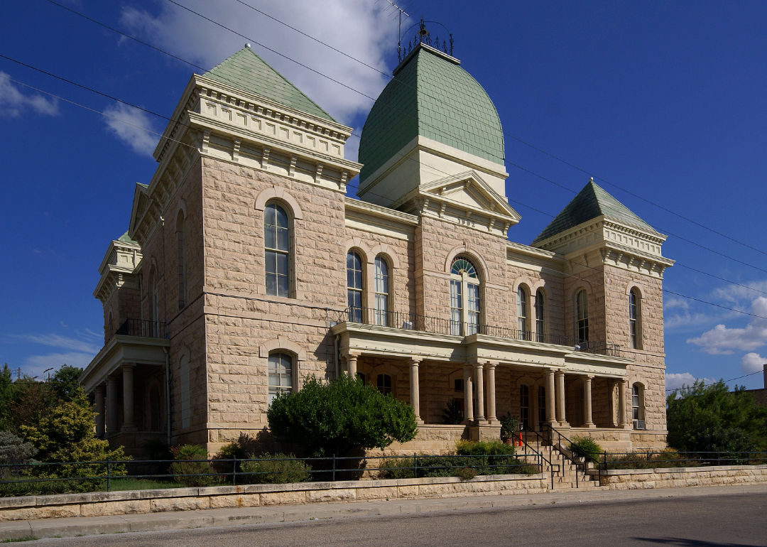
#50. Gregg County (tie)
– Life expectancy: 72.8 years
— 4.4 years lower than the state average
About
Gregg County is shaped by its strong community ties, where schools, churches, and civic traditions bring people together across both town and countryside. Longview, the county seat, stands as a hub for education, commerce, and culture, connecting the county’s smaller communities through shared institutions. The county’s character reflects the balance of urban energy and the steady rhythms of East Texas life.
Its history is rooted in the oil boom, which left a lasting imprint on the economy and identity of the region. Parks, festivals, and local events sustain cultural pride, while generational families maintain continuity across decades. Gregg County continues to represent a blend of history, community spirit, and resilience that defines its place in Texas.
Where is Gregg County?
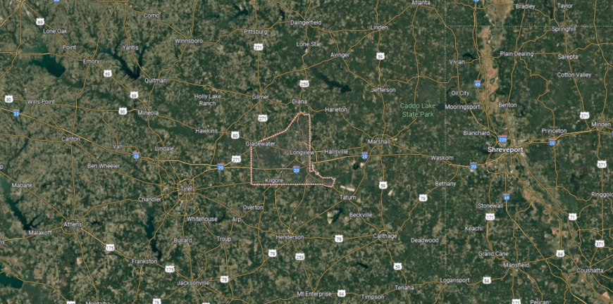
Gregg County is located in northeastern Texas, about 120 miles east of Dallas and roughly 60 miles west of Shreveport, Louisiana. Covering just over 270 square miles, the county sits within the Piney Woods region, an area known for its rolling hills, timberlands, and oil fields. Its position along Interstate 20 places it on a major east–west transportation corridor.
Longview, the county seat and largest city, lies near the center and serves as the hub for government, industry, and commerce. Other communities include Kilgore, noted for its historic ties to the East Texas Oil Field, as well as Gladewater and White Oak. With its mix of natural resources, highways, and active towns, Gregg County plays a key role in the economy of East Texas.
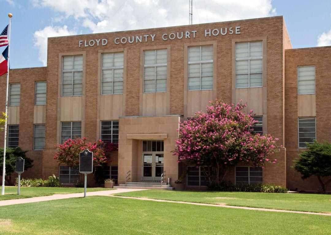
#49. Floyd County (tie)
– Life expectancy: 72.8 years
— 4.4 years lower than the state average
About
Floyd County rests on the High Plains of West Texas, where wide farmland and open skies define the landscape. Floydada, the county seat, serves as the center of schools, commerce, and civic life, linking smaller rural communities across the plains. The county’s identity reflects both its agricultural foundation and its close-knit communities.
Heritage is carried forward through fairs, festivals, and traditions that highlight the importance of farming and family. Generational ties remain strong, with families connected to the land through decades of work and community pride. Floyd County stands as a place where geography, heritage, and people remain closely bound together.
Where is Floyd County?
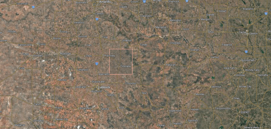
Floyd County is located in the South Plains of northwestern Texas, about 50 miles northeast of Lubbock. Covering just under 1,000 square miles, the county lies within the High Plains region, where flat farmland and wide horizons dominate the landscape. Cotton, sorghum, and livestock production shape much of its economy, with agriculture remaining the steady foundation of local life.
Floydada, the county seat, sits near the center and serves as the hub for government, schools, and commerce. Other small towns such as Lockney, Aiken, and Dougherty connect the surrounding farming communities across the plains. With its agricultural focus, rural towns, and ties to the South Plains, Floyd County reflects the working landscape of West Texas.
#48. Howard County (tie)
– Life expectancy: 72.8 years
— 4.4 years lower than the state average
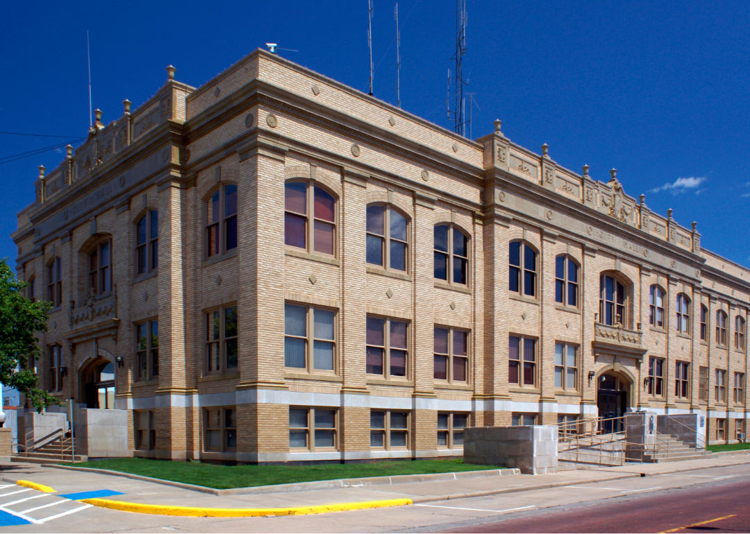
Howard County’s story is closely tied to the rise of the West Texas oil fields, which shaped its economy and growth throughout the 20th century. Big Spring, the county seat, developed as both an energy hub and a cultural center, connecting smaller rural communities across the region. The county’s identity reflects this legacy of industry alongside its ranching and agricultural roots.
Open plains, mesas, and wide skies form the backdrop of daily life, offering both livelihood and a sense of space. Festivals, school events, and community traditions continue to bring residents together and preserve a sense of continuity. Howard County remains a place where history, land, and community spirit intersect.
Where is Howard County?
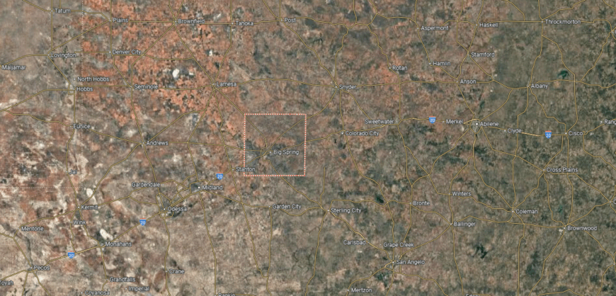
Howard County is situated in central Texas, about 100 miles south of Lubbock and roughly 250 miles west of Fort Worth. It covers over 900 square miles within the High Plains region, featuring flat to gently rolling terrain with a dry climate suited for ranching and energy development. The county is also positioned along Interstate 20, providing a key east–west travel route across West Texas.
Big Spring, the county seat, lies near the center and serves as the hub for government, commerce, and culture. Smaller communities such as Coahoma and Forsan are scattered across the countryside, connected by state highways and farm-to-market roads. With its ranching base, oil industry ties, and transportation corridors, Howard County plays an important role in the West Texas region.
#47. Gray County (tie)
– Life expectancy: 72.8 years
— 4.4 years lower than the state average

About
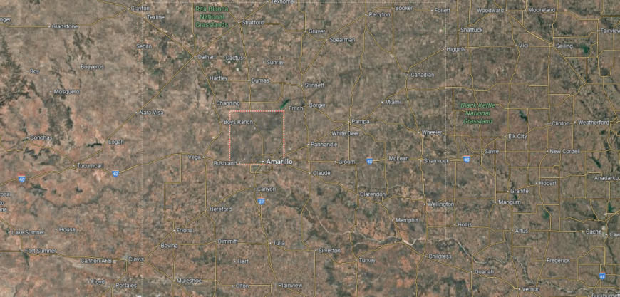
Gray County is found in the Texas Panhandle, about 60 miles east of Amarillo. It spans more than 900 square miles of High Plains terrain, with flat rangeland, wheat fields, and oil activity defining much of its economy. The county sits along Interstate 40, a major east–west corridor that follows the historic route of U.S. Highway 66.
Pampa, the county seat, is positioned near the center and anchors government, commerce, and education. Other towns such as McLean, known for its Route 66 heritage, and Lefors connect rural communities across the plains. With its mix of agriculture, energy, and historic highway ties, Gray County captures the character of the central Panhandle.
Where is Gray County?
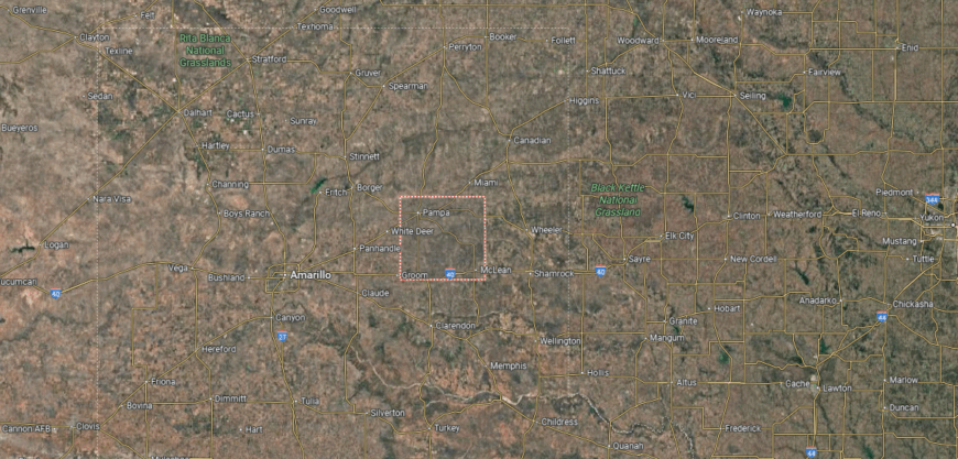
Gray County is located in the Texas Panhandle, about 60 miles east of Amarillo and 110 miles west of Oklahoma City. It covers just over 900 square miles of mostly flat to gently rolling terrain, part of the High Plains region. The county sits along Interstate 40, a major east–west corridor that follows the route of historic U.S. Route 66.
Pampa, the county seat, rests near the center and serves as the primary hub for government, business, and community life. Other small towns such as Lefors and McLean are spread across the county, with McLean noted for its Route 66 heritage. Agriculture and energy production, combined with its highway connections, give Gray County a central role in the Panhandle.
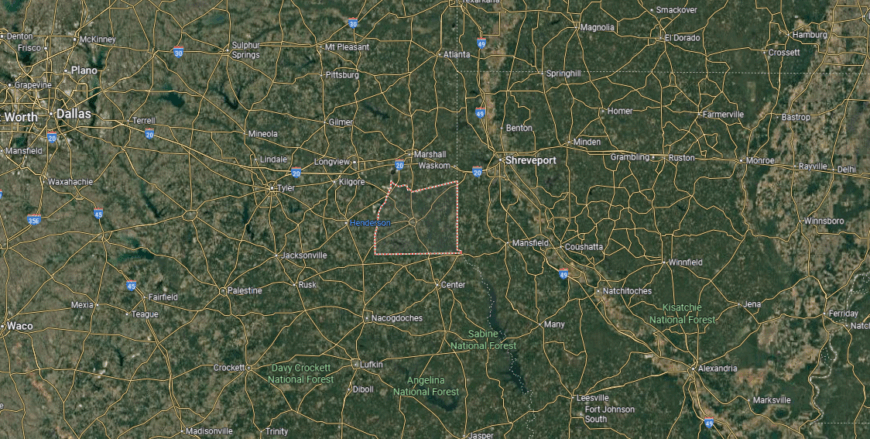
#46. Henderson County (tie)
– Life expectancy: 72.8 years
— 4.4 years lower than the state average
You may also like: Movies and TV shows casting in Texas
About
Henderson County lies in East Texas, where rolling hills, woodlands, and lakes shape both its scenery and daily life. Athens, the county seat, anchors schools, commerce, and cultural activity, connecting surrounding towns and rural areas. The county’s character reflects a blend of natural beauty and small-town tradition.
Fishing, festivals, and local gatherings provide a rhythm of community life that has carried on for generations. Agriculture and family roots continue to anchor many residents, while new growth adds energy to the region. Henderson County endures as a place where land, culture, and community remain closely bound together.
Where is Henderson County?
Henderson County is found in east Texas, about 60 miles southeast of Dallas and 35 miles west of Tyler. The county spans over 900 square miles within the Piney Woods region, blending forestland, farmland, and numerous lakes, including portions of Cedar Creek Reservoir and Lake Palestine. Its location places it within easy reach of both the Dallas–Fort Worth area and smaller East Texas cities.
Athens, the county seat, sits near the center and serves as the hub for government and commerce. Other communities such as Gun Barrel City, Chandler, and Malakoff lie around the county’s lakes and highways, providing both residential centers and recreational access. With its mix of woodlands, waterways, and small towns, Henderson County combines rural character with connections to larger urban areas.
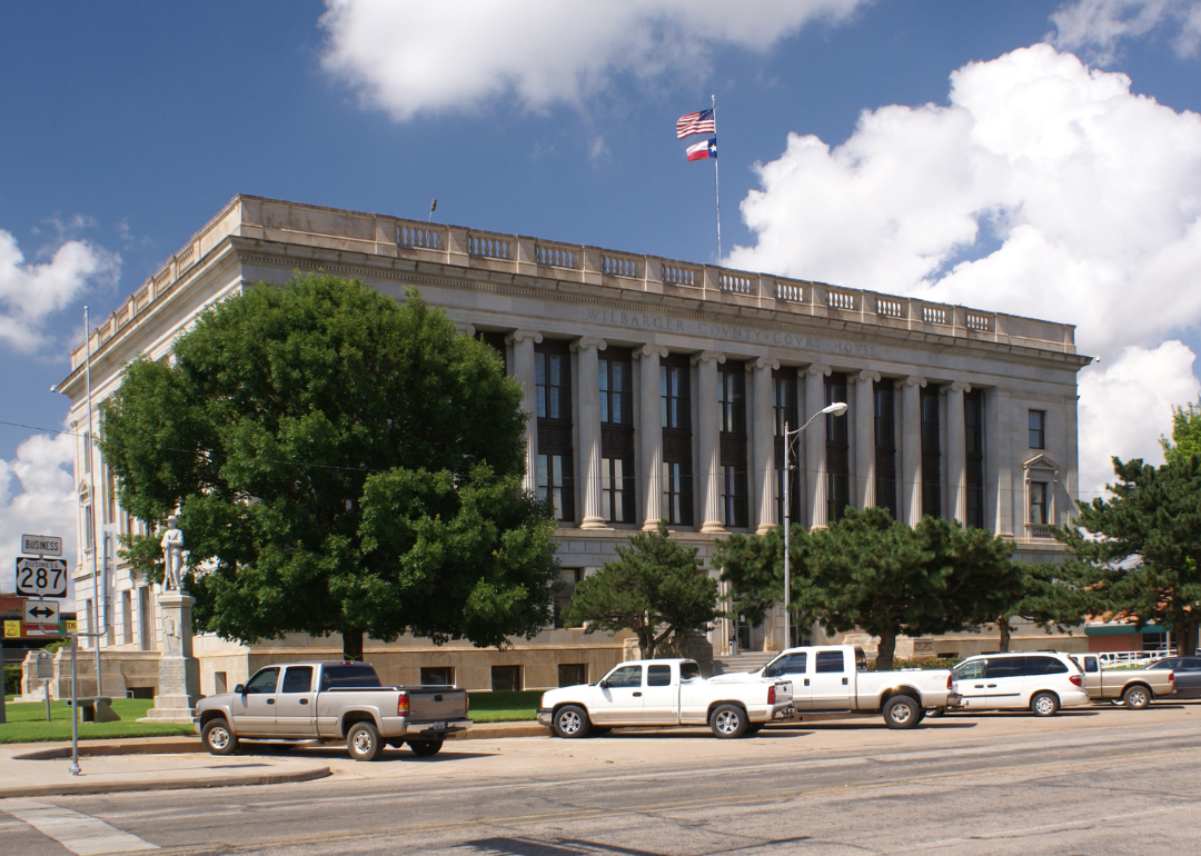
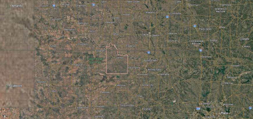
#45. Wilbarger County (tie)
– Life expectancy: 72.8 years
— 4.4 years lower than the state average
About
Wilbarger County carries a legacy rooted in the ranching and farming traditions that shaped its settlement on the Texas plains. Vernon, the county seat, grew as a hub for trade, schools, and civic life, connecting rural communities across the region. The county’s story reflects resilience forged through both agriculture and the frontier spirit.
Wide farmland, open skies, and the nearby Red River define the backdrop of daily living. Community pride shows through festivals, school events, and family networks that keep traditions alive. Wilbarger County stands as a place where history, land, and community remain firmly interwoven.
Where is Wilbarger County?
🔥 Would you like to save this?
Wilbarger County is located in North Texas along the Oklahoma border, about 130 miles northwest of Fort Worth and 50 miles west of Wichita Falls. It spans nearly 950 square miles of open rangeland and farmland, with the Pease River flowing across its landscape. The county lies within the rolling plains region, giving it broad agricultural potential.
Vernon, the county seat, is positioned near the center and serves as the main hub for government and commerce. Oklaunion, Harrold, and other small communities are spread through the countryside along state and U.S. highways. With its farming base, ranching tradition, and highway connections, Wilbarger County plays an important role in North Texas.
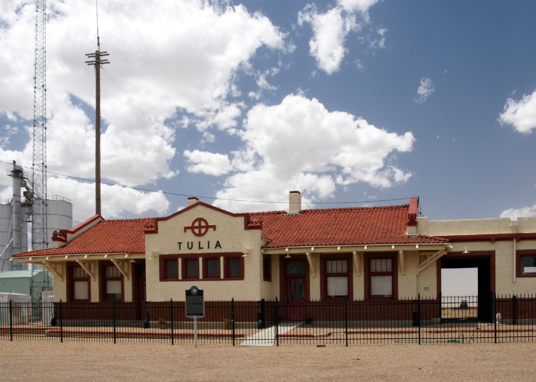
#44. Swisher County (tie)
– Life expectancy: 72.8 years
— 4.4 years lower than the state average
About
Swisher County is centered on the rhythms of community gatherings, school activities, and local traditions that bring neighbors together across the High Plains. Tulia, the county seat, serves as a hub for commerce, education, and civic life, tying together surrounding rural areas. The county’s identity reflects both small-town values and a deep agricultural foundation.
Flat farmland and open skies frame the landscape, supporting crops and livestock that have long sustained families here. Generational ties remain strong, with heritage passed down through festivals, church life, and shared histories. Swisher County endures as a place where culture, land, and family roots remain closely bound.
Where is Swisher County?
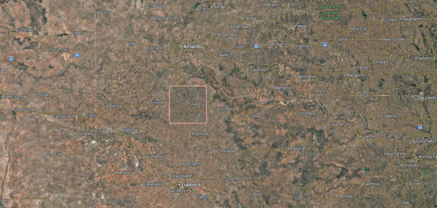
Swisher County is located in the Texas Panhandle, about 50 miles south of Amarillo and 100 miles north of Lubbock. It covers more than 900 square miles of flat High Plains terrain, much of it dedicated to cattle ranching and crop farming. The county also sits along Interstate 27, a major north–south highway through the region.
Tulia, the county seat, lies near the center and serves as the focal point for government, schools, and commerce. Smaller communities such as Kress and Happy are scattered along the highway and farming areas. With its agricultural base, rural communities, and transportation links, Swisher County reflects the character of the Panhandle.
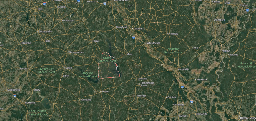
#43. Morris County
– Life expectancy: 72.7 years
— 4.5 years lower than the state average
About
Morris County sits in the woodlands of Northeast Texas, where forests, creeks, and rolling hills shape its natural setting. Daingerfield, the county seat, anchors schools, commerce, and civic traditions, tying together the county’s small communities. The county’s character reflects a balance of rural landscape and close-knit community life.
Its history includes farming, ironworks, and timber, industries that influenced growth and identity across generations. Festivals, church gatherings, and local events preserve traditions while sustaining a sense of belonging. Morris County remains a place where land, history, and community continue to weave together daily life.
Where is Morris County?
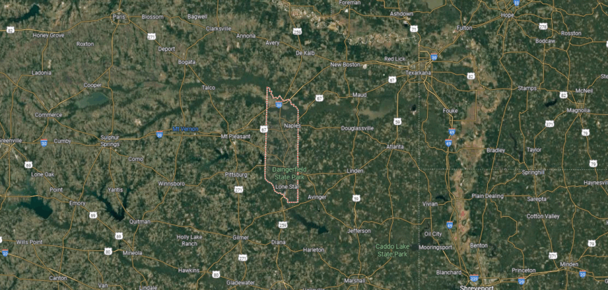
Morris County is situated in northeastern Texas within the Piney Woods region. It lies about 135 miles east of Dallas and 70 miles southwest of Texarkana, covering just under 260 square miles of rolling hills and forestland. The county’s geography combines timber resources with farmland, giving it both agricultural and industrial importance.
Daingerfield, the county seat, rests near the center and serves as the hub for government and local commerce. Smaller towns such as Lone Star, Naples, and Omaha connect the surrounding rural areas. With its wooded terrain, small communities, and regional industries, Morris County represents the character of northeast Texas.
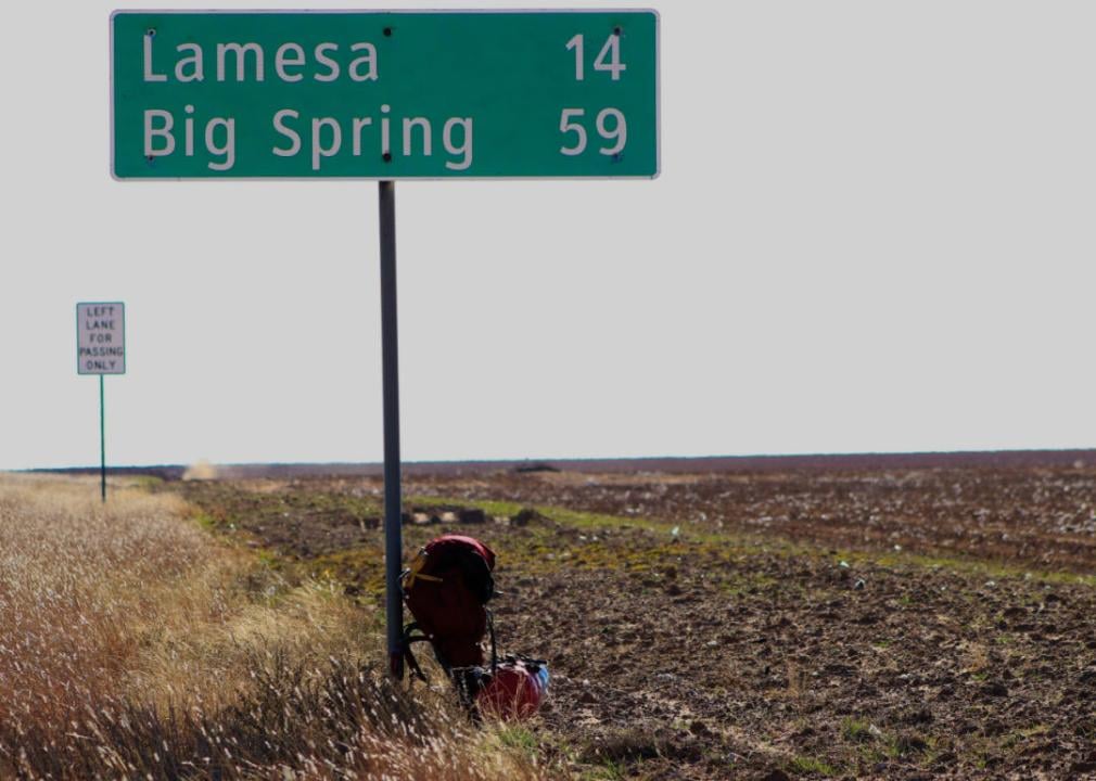
#42. Dawson County (tie)
– Life expectancy: 72.6 years
— 4.6 years lower than the state average
About
Dawson County’s story is closely tied to the rise of West Texas farming and the oil industry, both of which shaped its economy and growth. Lamesa, the county seat, developed as a hub for trade, education, and civic life, connecting smaller rural communities. The county’s identity reflects resilience built from its agricultural and industrial heritage.
Flat plains and open skies define the landscape, supporting cotton fields and energy development that continue to sustain local life. Festivals, school traditions, and family ties provide continuity across generations. Dawson County endures as a place where history, land, and community remain firmly linked.
Where is Dawson County?
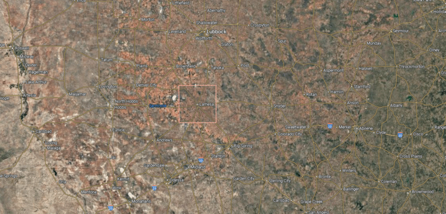
Dawson County is located in west Texas, about 60 miles south of Lubbock and 90 miles north of Midland. It covers nearly 900 square miles within the Llano Estacado, a region known for its flat High Plains terrain. Farming and oil production dominate the county’s landscape, with cotton fields and pump jacks spread across the countryside.
Lamesa, the county seat, sits near the center and serves as the hub for government, business, and education. Smaller communities such as Los Ybanez and Welch are scattered across the rural landscape. With its agricultural base, energy resources, and central highways, Dawson County plays a key role in the South Plains region of Texas.
#41. Orange County (tie)
– Life expectancy: 72.6 years
— 4.6 years lower than the state average
You may also like: Best private high schools in Texas
About
Orange County is shaped by strong community ties, where festivals, school events, and church gatherings reflect both local pride and Gulf Coast traditions. Orange, the county seat, serves as a hub for commerce, education, and cultural activity, connecting smaller towns across the region. The county’s character blends small-town values with the influence of its coastal setting.
Its history is tied to shipbuilding, petrochemical industries, and the waterways that frame its economy and growth. Marshes, rivers, and forests provide both livelihood and recreation, grounding families in a distinctive landscape. Orange County endures as a place where culture, history, and land remain inseparably linked.
Where is Orange County?
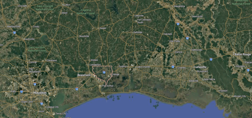
Orange County is found in southeastern Texas along the Louisiana border, where the Sabine River meets the Gulf Coast plain. It is about 110 miles east of Houston and 25 miles northeast of Beaumont, covering more than 350 square miles of flat lowlands and river bottoms. The county’s position along the Sabine River makes it both a transportation and industrial hub.
Orange, the county seat, sits near the river and serves as the center for government and commerce. Other communities include Bridge City, West Orange, and Vidor, each connected by major highways and local industries. With its mix of waterways, petrochemical plants, and small towns, Orange County reflects the economic and geographic character of coastal Texas.
#40. Lamar County
– Life expectancy: 72.5 years
— 4.7 years lower than the state average
About
Lamar County lies in Northeast Texas, where rolling prairies, wooded areas, and fertile farmland shape its landscape. Paris, the county seat, serves as a hub for education, commerce, and civic life, linking the county’s smaller towns and rural stretches. The county’s identity reflects the balance between natural setting and community growth.
Its history includes farming, ranching, and regional trade, all of which influenced settlement and development across generations. Festivals, church traditions, and local events strengthen community bonds while honoring shared heritage. Lamar County continues to stand as a place where geography, history, and culture remain closely tied.
Where is Lamar County?
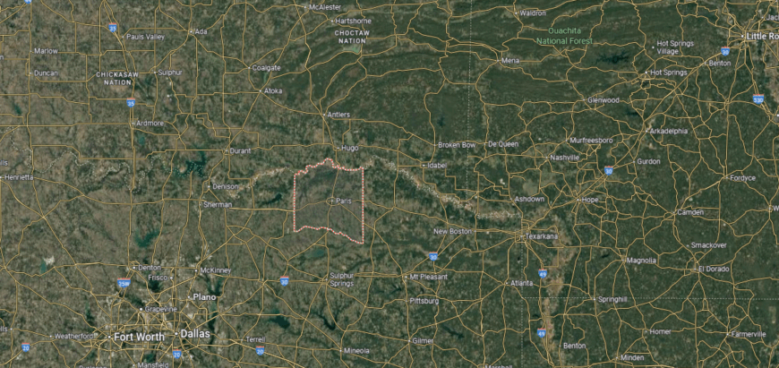
Lamar County is located in northeastern Texas along the Oklahoma border. It lies about 100 miles northeast of Dallas and covers more than 900 square miles of rolling prairies, farmland, and wooded areas. The Red River forms its northern boundary, providing a natural border with Oklahoma.
Paris, the county seat, sits near the center and serves as the hub for government, culture, and commerce. Smaller towns such as Reno, Blossom, and Roxton connect the rural parts of the county. With its Red River frontage, farmland, and strong community centers, Lamar County anchors a key part of northeast Texas.
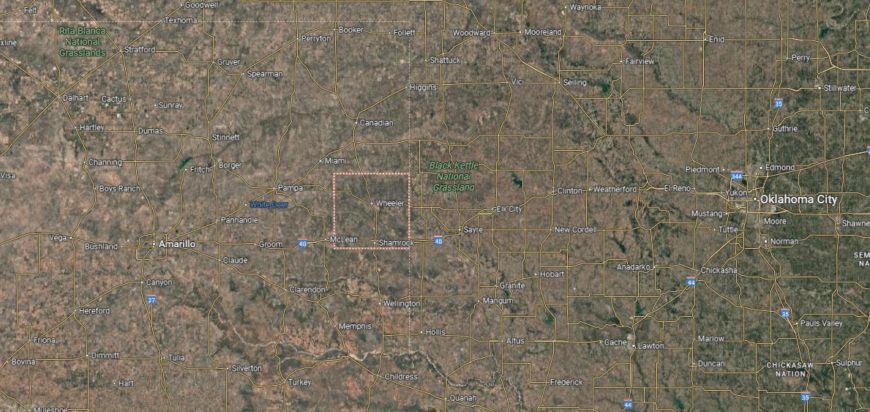
#39. Wheeler County (tie)
– Life expectancy: 72.4 years
— 4.8 years lower than the state average
About
Wheeler County carries a legacy tied to ranching and farming, which shaped its settlement on the Texas plains. Wheeler, the county seat, has long been a center for schools, commerce, and civic activity, connecting rural families across the region. The county’s story reflects both frontier resilience and the enduring traditions of the land.
Wide prairies and open skies frame the daily life of its residents, supporting agriculture as a steady foundation. Festivals, school events, and local traditions provide continuity across generations. Wheeler County stands as a place where history, landscape, and community remain firmly connected.
Where is Wheeler County?
🔥 Would you like to save this?
Wheeler County is located in the eastern Texas Panhandle, about 140 miles east of Amarillo and close to the Oklahoma border. It spans just over 900 square miles of High Plains terrain, with open rangeland, wheat fields, and gently rolling prairies. U.S. Highways 83 and 152 cross the county, providing north–south and east–west travel routes.
Wheeler, the county seat, lies near the center and serves as the hub for local government and commerce. Shamrock, another key town, sits along historic Route 66 and remains a cultural landmark of the county. With its mix of agriculture, highways, and small towns, Wheeler County reflects the rural character of the Panhandle.
#38. Ector County (tie)
– Life expectancy: 72.4 years
— 4.8 years lower than the state average
About
Ector County is shaped by the energy of its community, where school events, civic gatherings, and local traditions reflect the spirit of West Texas. Odessa, the county seat, serves as a hub for education, commerce, and cultural activity, connecting residents across the region. The county’s identity blends small-town values with the pulse of a growing urban center.
Its history is tied to the oil industry, which continues to influence both the economy and daily life. Open plains and wide skies frame the land, reminding residents of the region’s frontier roots. Ector County remains a place where culture, history, and landscape are firmly interwoven.
Where is Ector County?
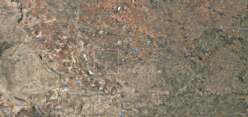
Ector County is situated in western Texas within the Permian Basin, about 140 miles south of Lubbock and 20 miles west of Midland. It covers nearly 900 square miles of flat, arid plains, where oil production and energy industries dominate the landscape. The county’s location along Interstate 20 makes it a major hub in West Texas.
Odessa, the county seat and largest city, lies at the center and serves as the focal point for government, commerce, and culture. Smaller communities such as Goldsmith and Penwell are scattered across the county, tied to both ranching and the oil fields. With its petroleum base, highway connections, and urban center, Ector County plays a vital role in the region’s economy.
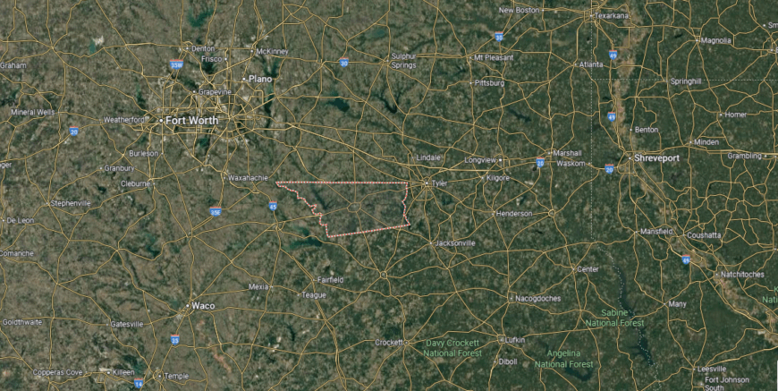
#37. Tyler County (tie)
– Life expectancy: 72.4 years
— 4.8 years lower than the state average
About
Tyler County lies in the Piney Woods of East Texas, where forests, rivers, and rolling hills shape both its scenery and way of life. Woodville, the county seat, anchors schools, commerce, and civic life, connecting the surrounding rural areas. The county’s character reflects a blend of natural setting and strong community ties.
Its history includes farming, timber, and small-town traditions that continue to influence daily living. Festivals, church events, and family networks sustain cultural pride and reinforce a sense of belonging. Tyler County endures as a place where land, history, and community remain deeply connected.
Where is Tyler County?
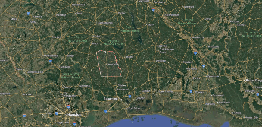
Tyler County is located in southeastern Texas within the Piney Woods region. It lies about 60 miles north of Beaumont and covers more than 900 square miles of heavily forested hills and river valleys. The Neches River flows along its western border, while the Angelina National Forest sits nearby, shaping much of its natural character.
Woodville, the county seat, is positioned near the center and serves as the hub for government and local life. Smaller communities such as Colmesneil, Chester, and Warren are spread throughout the county, many tied to timber and farming. With its dense woodlands, small towns, and outdoor resources, Tyler County reflects the rural heritage of East Texas.
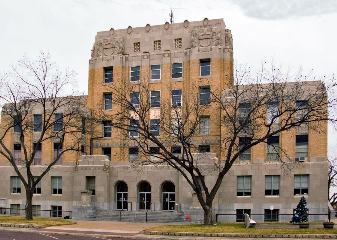
#36. Eastland County (tie)
– Life expectancy: 72.4 years
— 4.8 years lower than the state average
You may also like: How much manufacturers in Texas spend on equipment
About
Eastland County’s story is marked by its oil boom of the early 20th century, which reshaped the economy and left a lasting imprint on its communities. Eastland, the county seat, developed as a hub for commerce, schools, and civic activity, linking smaller towns across the region. The county’s identity reflects both its frontier past and its industrial legacy.
Rolling hills, farmland, and small lakes frame the landscape, supporting agriculture and outdoor life. Festivals, school traditions, and church gatherings carry forward community ties across generations. Eastland County stands as a place where history, land, and cultural life remain firmly interwoven.
Where is Eastland County?
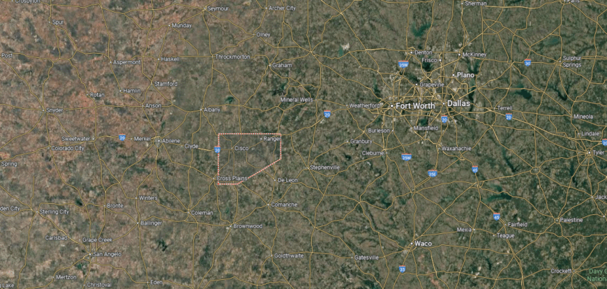
Eastland County is located in north-central Texas, about 95 miles west of Fort Worth and 55 miles east of Abilene. It covers just under 1,000 square miles of rolling plains, with farmland, wooded areas, and oilfields shaping its landscape. The county sits along Interstate 20, giving it a direct link between West Texas and the Dallas–Fort Worth area.
Eastland, the county seat, lies near the center and serves as the hub for government and commerce. Other towns include Cisco, Ranger, and Gorman, each with their own historic ties to the oil boom and early settlement. With its mix of agriculture, energy, and transportation routes, Eastland County reflects the character of central West Texas.
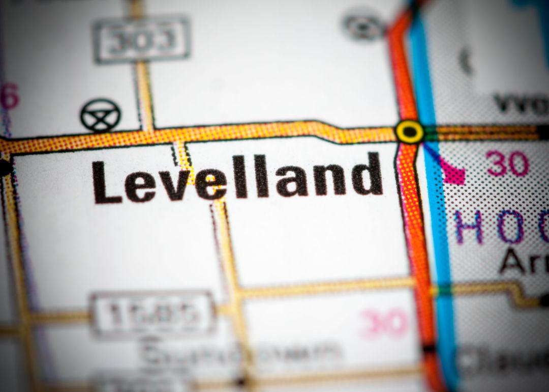
#35. Hockley County (tie)
– Life expectancy: 72.3 years
— 4.9 years lower than the state average
About
Hockley County lies on the South Plains of West Texas, where flat farmland and broad horizons define its landscape. Levelland, the county seat, anchors schools, commerce, and civic life, serving as a central link for the region’s rural communities. The county’s identity reflects both its agricultural roots and its steady role in regional development.
Cotton farming and ranching have long been foundations of the local economy, joined later by oil and energy industries. Community pride shows through festivals, school traditions, and the generational ties that keep families rooted. Hockley County stands as a place where land, history, and community remain firmly connected.
Where is Hockley County?
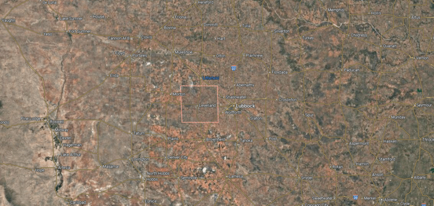
Hockley County is located in the South Plains of northwestern Texas, about 30 miles west of Lubbock. Spanning more than 900 square miles, the county is part of the High Plains region, with level terrain suited for cotton farming, ranching, and petroleum production. Its position places it in one of the state’s most productive agricultural belts.
Levelland, the county seat, stands at the center as the primary hub for government and commerce. Other communities such as Sundown, Smyer, and Anton support the surrounding rural areas. With its flat farmland, oil resources, and highway connections, Hockley County reflects the dual character of agriculture and energy that defines the South Plains.
#34. Marion County (tie)
– Life expectancy: 72.3 years
— 4.9 years lower than the state average
🔥 Would you like to save this?
About
Marion County carries a legacy shaped by river trade and timber, with Jefferson, the county seat, once serving as a major port on the Big Cypress Bayou. Historic buildings, cultural landmarks, and preserved traditions give the county a distinctive identity tied to its past. The story of Marion County reflects both its economic roots and its resilience through changing times.
Forested landscapes, waterways, and small-town communities define daily life, supporting both work and recreation. Festivals, antique markets, and family traditions keep heritage alive across generations. Marion County continues to stand as a place where history, land, and culture remain closely bound.
Where is Marion County?
Marion County is located in northeast Texas along the Louisiana border, within the Piney Woods region. It lies about 150 miles east of Dallas and 40 miles north of Shreveport, Louisiana, covering just over 380 square miles of forestland, lakes, and river valleys. The county’s eastern edge is marked by Caddo Lake, one of the largest natural lakes in the South.
Jefferson, the county seat, sits near Big Cypress Bayou and is known for its historic role as a 19th-century riverport town. Smaller communities such as Lodi, Lassater, and Smithland are scattered through the wooded countryside. With its lakes, waterways, and rich history, Marion County blends natural beauty with cultural heritage in East Texas.
#33. Collingsworth County (tie)
– Life expectancy: 72.3 years
— 4.9 years lower than the state average
About
Collingsworth County is defined by its small-town gatherings, school events, and community traditions that keep neighbors closely connected across the plains. Wellington, the county seat, provides a hub for education, commerce, and civic life, linking together the county’s rural communities. The county’s identity reflects both its agricultural base and the strong bonds of community life.
Its history is tied to ranching and farming, which continue to shape both the economy and the rhythm of daily living. Wide fields and open skies frame the land, offering continuity for families rooted here across generations. Collingsworth County endures as a place where culture, history, and geography remain inseparable.
Where is Collingsworth County?
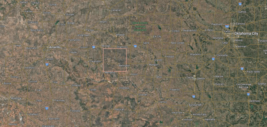
Collingsworth County is located in the southeastern Texas Panhandle, bordering Oklahoma along the Red River. It lies about 100 miles east of Amarillo and covers just over 900 square miles of open plains, rolling prairies, and farmland. The county’s landscape supports ranching, crop production, and rural communities spread across wide stretches of land.
Wellington, the county seat, sits near the center and serves as the hub for government, schools, and commerce. Smaller towns such as Dodson, Samnorwood, and Quail connect the outlying areas. With its agricultural base, open terrain, and ties to the Red River, Collingsworth County reflects the rural character of the Panhandle.
#32. McCulloch County (tie)
– Life expectancy: 72.3 years
— 4.9 years lower than the state average
About
McCulloch County lies in the Hill Country of central Texas, often called the “Heart of Texas” for its central location. Brady, the county seat, serves as a hub for schools, commerce, and civic life, connecting surrounding ranching and farming communities. The county’s identity reflects both its natural landscape and its role as a crossroads in the state.
Ranching, farming, and local trade have long shaped the economy, while festivals and community traditions sustain a strong cultural spirit. Families with deep generational roots help preserve heritage and continuity across the region. McCulloch County endures as a place where land, history, and community remain firmly tied together.
Where is McCulloch County?
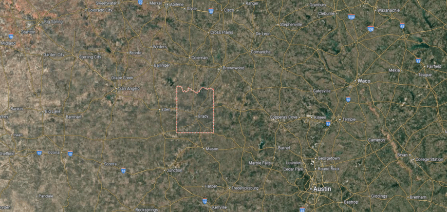
McCulloch County is located in the heart of Texas, often called the “geographic center” of the state. It lies about 140 miles northwest of Austin and covers more than 1,000 square miles of rolling Hill Country terrain, with oak woodlands, pastures, and sections of the San Saba River. The county’s central location gives it connections in every direction across Texas.
Brady, the county seat, sits near the exact geographic center and serves as the hub for commerce, government, and community life. Smaller communities such as Melvin, Lohn, and Rochelle are scattered across the ranchland and farmlands. With its central position, diverse landscapes, and small-town roots, McCulloch County reflects the balance of Hill Country and West Texas.
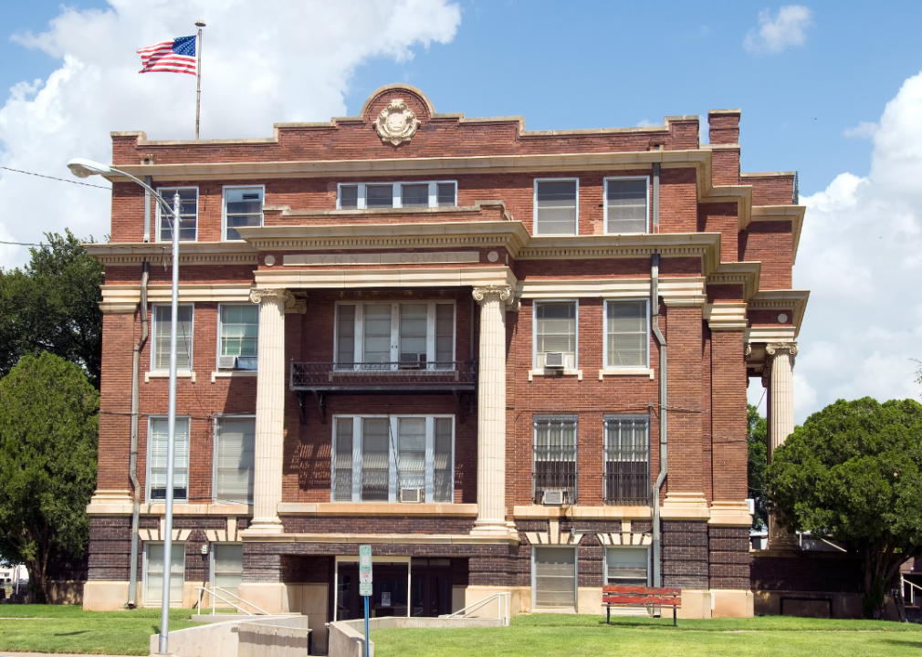
#31. Lynn County (tie)
– Life expectancy: 72.3 years
— 4.9 years lower than the state average
You may also like: How syringe exchanges in Texas reduce the spread of disease
About
Lynn County’s story is tied to the settlement of the South Plains, where farming and ranching shaped its early growth. Tahoka, the county seat, developed as a hub for schools, trade, and civic life, anchoring the surrounding rural communities. The county’s identity reflects resilience built from both agriculture and small-town traditions.
Flat farmland and open skies frame the landscape, supporting cotton production as a steady foundation of the local economy. Festivals, church gatherings, and family ties keep heritage alive across generations. Lynn County stands as a place where history, land, and community remain closely connected.
Where is Lynn County?

Lynn County is situated in the South Plains of northwestern Texas, about 30 miles south of Lubbock. It spans nearly 900 square miles of flat High Plains terrain, much of it devoted to cotton farming, cattle ranching, and oil production. The county lies within one of Texas’s most productive agricultural regions.
Tahoka, the county seat, is positioned near the center and serves as the hub for government and commerce. Smaller towns such as Wilson, New Home, and O’Donnell connect the surrounding rural areas. With its mix of farmland, ranches, and energy resources, Lynn County plays a steady role in the South Plains economy.
#30. Camp County (tie)
– Life expectancy: 72.3 years
— 4.9 years lower than the state average
About
Camp County is shaped by community spirit, where school events, church gatherings, and local festivals bring residents together. Pittsburg, the county seat, anchors commerce, education, and cultural activity, linking smaller communities across the area. The county’s identity reflects both small-town traditions and the resilience of East Texas life.
Its history includes farming, timber, and regional trade, industries that influenced growth and character over generations. Rolling hills, forests, and creeks frame the land, providing both livelihood and recreation. Camp County continues to stand as a place where culture, land, and history remain firmly bound.
Where is Camp County?
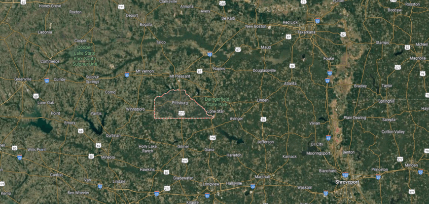
Camp County is located in northeastern Texas within the Piney Woods region. It is one of the smallest counties in the state, covering just over 200 square miles of rolling hills, forests, and farmland. The county lies about 120 miles east of Dallas and 60 miles southwest of Texarkana.
Pittsburg, the county seat, sits near the center and serves as the hub for government, business, and community life. Smaller rural communities and farms are scattered across the countryside, connected by state highways. With its compact size, wooded terrain, and strong agricultural ties, Camp County reflects the rural character of northeast Texas.
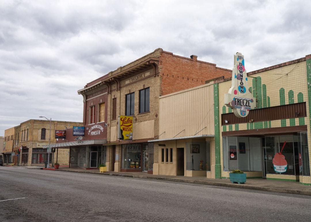
#29. Young County (tie)
– Life expectancy: 72.2 years
— 5.0 years lower than the state average
About
Young County lies in North Texas, where prairies, rivers, and rolling hills shape its landscape and daily life. Graham, the county seat, serves as a hub for schools, commerce, and civic traditions, connecting nearby towns and rural communities. The county’s identity reflects both its natural setting and its enduring ranching heritage.
Its history includes frontier forts, cattle ranching, and the oil industry, each leaving a lasting mark on the region. Festivals, rodeos, and family-centered traditions continue to strengthen community bonds. Young County endures as a place where land, history, and culture remain closely tied.
Where is Young County?
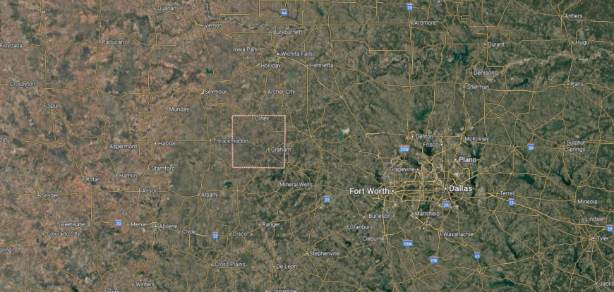
Young County is located in north-central Texas, about 95 miles northwest of Fort Worth and 65 miles south of Wichita Falls. It covers more than 900 square miles of rolling plains, mesquite-covered hills, and farmland, with the Brazos River crossing parts of the county. The landscape supports ranching, farming, and oil production, which have long shaped its economy.
Graham, the county seat, lies near the center and serves as the hub for government, commerce, and community life. Smaller towns such as Olney, Newcastle, and Loving are spread across the countryside, connected by state highways. With its mix of agriculture, energy, and small-town centers, Young County represents the character of north-central Texas.
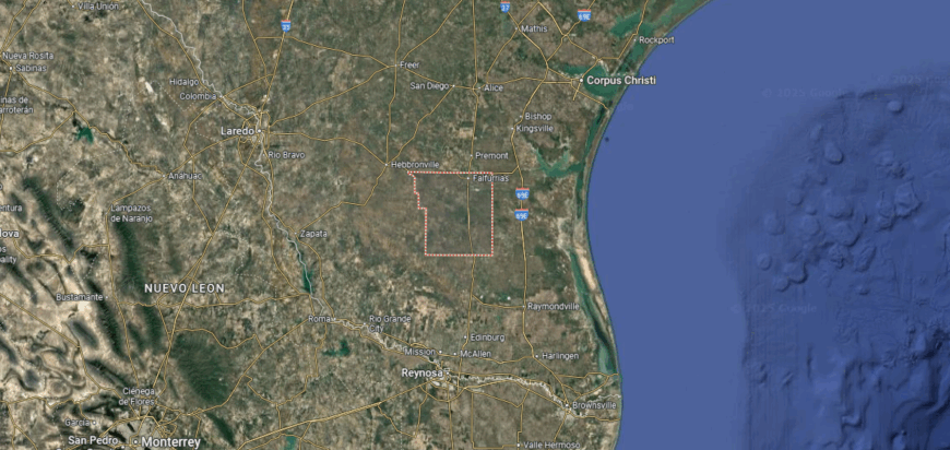
#28. Jim Wells County (tie)
– Life expectancy: 72.2 years
— 5.0 years lower than the state average
About
Jim Wells County carries a legacy tied to South Texas ranching, farming, and the railroads that shaped its settlement. Alice, the county seat, grew as a hub for commerce, schools, and cultural life, linking rural communities across the region. The county’s identity reflects both its frontier roots and its role in regional trade.
Flat plains and brush country define the land, supporting agriculture and energy development as key parts of the economy. Festivals, music traditions, and strong family ties keep cultural heritage alive across generations. Jim Wells County remains a place where history, land, and community are firmly connected.
Where is Jim Wells County?
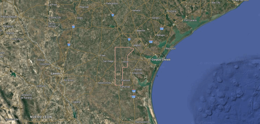
Jim Wells County is located in southern Texas, about 45 miles west of Corpus Christi. It covers over 850 square miles of brush country, farmland, and gently rolling plains within the South Texas region. The county’s position links the Gulf Coast to the inland areas of the state, making it an important crossroads.
Alice, the county seat, sits near the center and serves as the hub for government, commerce, and oilfield services. Smaller communities such as Orange Grove, Premont, and Sandia connect the surrounding rural areas. With its agricultural roots, energy ties, and central location, Jim Wells County plays a key role in South Texas.
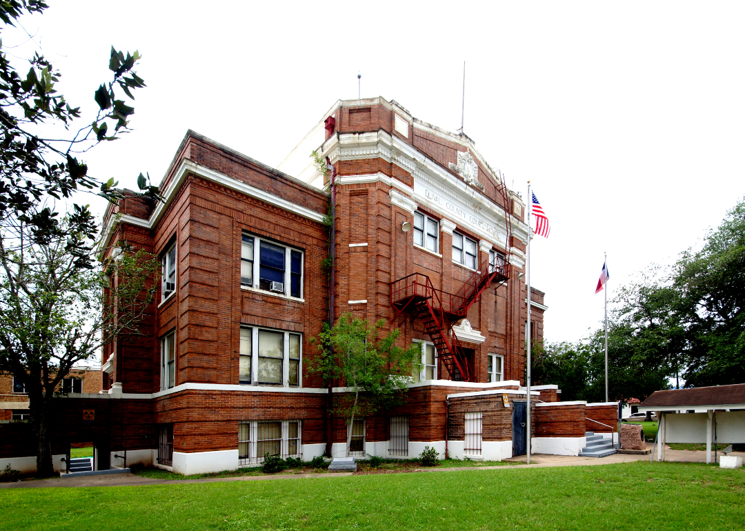
#27. Duval County (tie)
– Life expectancy: 72.2 years
— 5.0 years lower than the state average
About
Duval County is marked by strong community ties, where church gatherings, local celebrations, and music traditions reflect the heritage of South Texas. San Diego, the county seat, serves as the hub for schools, commerce, and civic life, linking the county’s rural communities together. The county’s identity blends small-town spirit with a cultural legacy rooted in Hispanic traditions.
Its history includes ranching, mining, and political influence, each leaving an imprint on the county’s development. The brush country landscape provides both livelihood and continuity for families with deep generational roots. Duval County stands as a place where culture, history, and land remain firmly connected.
Where is Duval County?
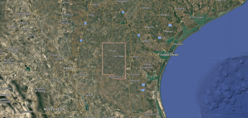
Duval County is located in South Texas, about 70 miles west of Corpus Christi and 60 miles south of San Antonio. It spans more than 1,700 square miles of brush country, rangeland, and oil fields, reflecting the semiarid terrain of the region. The county has long been tied to ranching and energy production.
San Diego, the county seat, sits near the center and serves as the hub for government and local services. Smaller towns such as Benavides, Freer, and Realitos are spread across the wide countryside, connected by state highways. With its ranching heritage, energy resources, and rural communities, Duval County represents the character of South Texas.
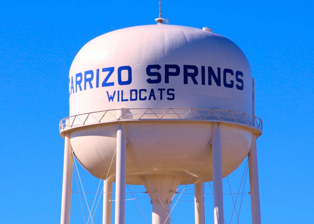
#26. Dimmit County (tie)
– Life expectancy: 72.2 years
— 5.0 years lower than the state average
You may also like: Texas small businesses thrive in these counties
About
Dimmit County lies in South Texas, where brush country, wide plains, and the Nueces River shape its setting. Carrizo Springs, the county seat, serves as the center of schools, commerce, and civic life, tying together nearby rural communities. The county’s identity reflects both its land and its role in agriculture and ranching.
Its history includes early settlement, cattle ranching, and later oil and gas development, each contributing to local growth. Festivals, family traditions, and community gatherings preserve cultural ties across generations. Dimmit County continues to stand as a place where geography, history, and heritage remain closely linked.
Where is Dimmit County?
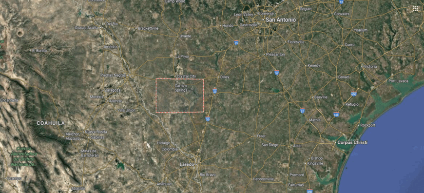
Dimmit County is situated in South Texas, about 110 miles southwest of San Antonio and 45 miles north of the U.S.–Mexico border. Covering over 1,300 square miles, the county lies within the Brush Country region, marked by mesquite, cactus, and wide stretches of rangeland. The Nueces River runs along part of its boundary, supporting both farming and ranching.
Carrizo Springs, the county seat, is located near the center and serves as the hub for government, commerce, and community life. Smaller communities such as Asherton, Big Wells, and Catarina are scattered across the county, tied to agriculture and oil activity. With its mix of ranchlands, energy production, and borderland setting, Dimmit County reflects the landscape and economy of South Texas.
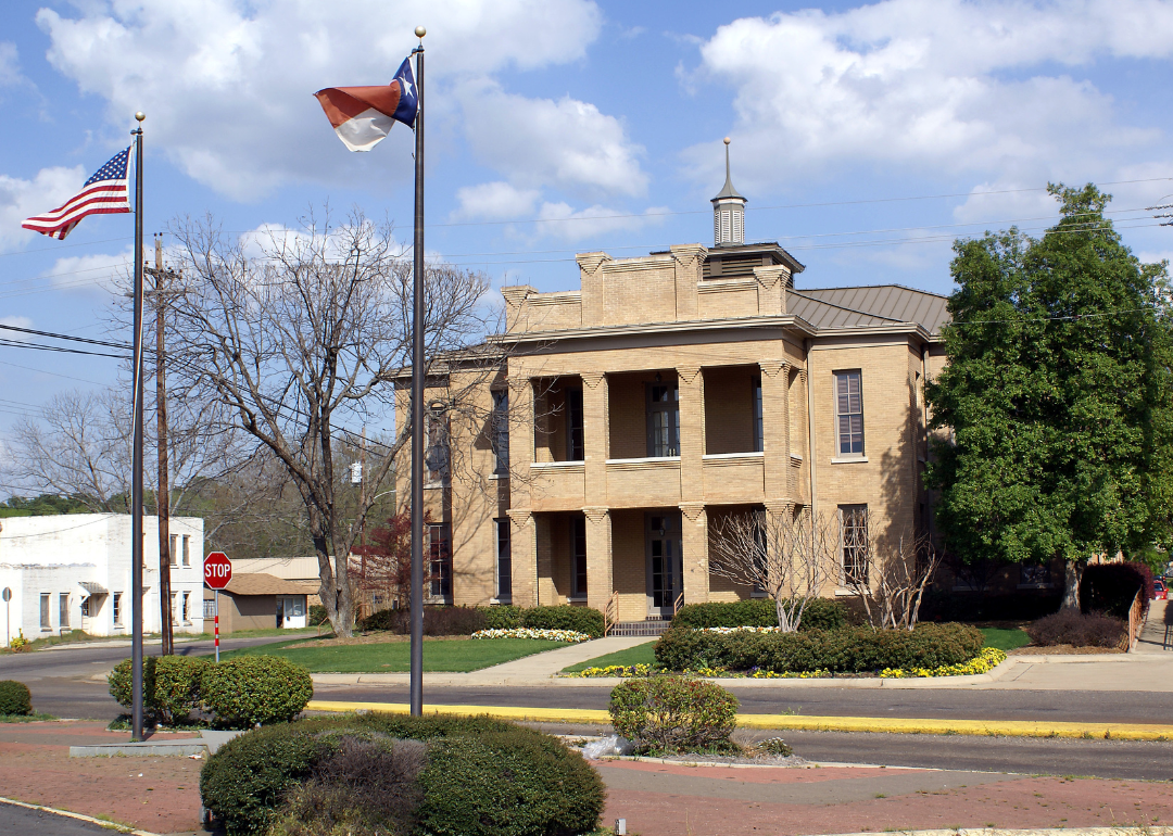
#25. Shelby County (tie)
– Life expectancy: 72.2 years
— 5.0 years lower than the state average
About
Shelby County carries a legacy rooted in early Texas settlement, with deep ties to frontier life and the development of East Texas communities. Center, the county seat, serves as a hub for schools, commerce, and civic traditions, linking towns across the region. The county’s identity reflects both its historic roots and its enduring rural culture.
Forests, rolling hills, and farmland provide the backdrop for daily life, supporting agriculture and timber as central parts of the economy. Festivals, church events, and family gatherings sustain continuity and pride across generations. Shelby County remains a place where history, land, and community stay firmly connected.
Where is Shelby County?
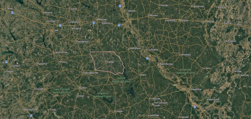
Shelby County is found in eastern Texas along the Louisiana border, within the Piney Woods region. It lies about 140 miles northeast of Houston and 60 miles southeast of Longview, covering more than 800 square miles of forestland, farmland, and rolling hills. The Sabine National Forest and Toledo Bend Reservoir touch parts of the county, adding to its natural setting.
Center, the county seat, is located near the middle and serves as the hub for government and community life. Other towns such as Timpson, Tenaha, and Joaquin connect the surrounding rural areas and provide links to Louisiana. With its wooded terrain, reservoirs, and small-town centers, Shelby County reflects the natural and cultural character of East Texas.
#24. Armstrong County (tie)
– Life expectancy: 72.1 years
— 5.1 years lower than the state average
About
Armstrong County is defined by the close bonds of its rural communities, where school events, church gatherings, and local celebrations carry on long-standing traditions. Claude, the county seat, anchors civic life and connects scattered ranching and farming families across the High Plains. The county’s identity reflects both small-town spirit and the enduring ties of West Texas heritage.
Its history is rooted in cattle ranching and frontier settlement, which shaped both economy and culture over generations. Wide prairies and open skies frame the landscape, providing a steady foundation for ranch life. Armstrong County stands as a place where culture, history, and land remain closely bound.
Where is Armstrong County?

Armstrong County is located in the Texas Panhandle, about 25 miles southeast of Amarillo. It spans nearly 900 square miles of High Plains terrain, with open rangeland, canyons, and stretches of the Prairie Dog Town Fork of the Red River running through the county. Agriculture, particularly cattle ranching, has long defined its landscape and economy.
Claude, the county seat, sits near the center and serves as the hub for government and local services. Smaller communities such as Washburn and Goodnight are scattered across the plains, connected by U.S. Highway 287. With its ranchlands, wide-open spaces, and proximity to Palo Duro Canyon, Armstrong County reflects the rugged character of the Panhandle.
#23. Cass County (tie)
– Life expectancy: 72.1 years
— 5.1 years lower than the state average
About
Cass County lies in the Piney Woods of Northeast Texas, where forests, streams, and rolling hills shape its natural setting. Linden, the county seat, provides a hub for schools, commerce, and civic life, connecting smaller communities across the region. The county’s character reflects both its wooded landscape and the traditions of East Texas living.
Its history is tied to farming, timber, and trade, industries that have influenced settlement and growth for generations. Festivals, music, and community events highlight local culture and sustain a strong sense of identity. Cass County remains a place where land, history, and community come together in daily life.
Where is Cass County?
Cass County is situated in the northeastern corner of Texas along the Louisiana and Arkansas borders. It lies about 160 miles east of Dallas and 30 miles south of Texarkana, covering more than 950 square miles within the Piney Woods region. The terrain features rolling hills, dense forests, and farmland, with natural resources shaping much of the county’s history.
Linden, the county seat, sits near the center and serves as the hub for government and community life. Atlanta, the largest city, lies in the eastern part of the county and anchors much of the area’s commerce and industry. With its wooded landscape, border location, and network of small towns, Cass County reflects the character of northeast Texas.
#22. Panola County (tie)
– Life expectancy: 72.1 years
— 5.1 years lower than the state average
About
Panola County carries a legacy tied to early settlement, farming, and the timber industry that helped shape East Texas. Carthage, the county seat, developed as a hub for schools, commerce, and civic life, connecting surrounding rural communities. The county’s identity reflects both its historic roots and its role as a cultural center.
Rolling hills, forests, and farmland frame the land, supporting agriculture and outdoor life for generations. Festivals, church events, and the strong influence of music preserve traditions and strengthen community ties. Panola County endures as a place where history, culture, and land remain deeply connected.
Where is Panola County?
Panola County is located in eastern Texas along the Louisiana border. It lies about 150 miles southeast of Dallas and 35 miles south of Marshall, covering just over 800 square miles of rolling hills, forests, and farmland. The Sabine River flows along its eastern edge, shaping both the landscape and local industry.
Carthage, the county seat, rests near the center and serves as the hub for government, culture, and commerce. Smaller communities such as Beckville and Gary City connect the surrounding rural areas. With its timber resources, farmland, and strong cultural ties, Panola County is a key part of the Piney Woods region of East Texas.
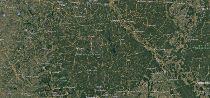
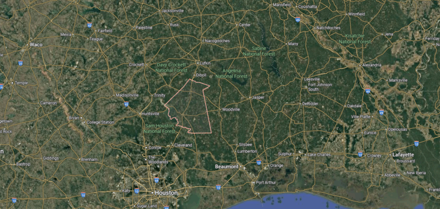
#21. Jasper County (tie)
– Life expectancy: 72.0 years
— 5.2 years lower than the state average
You may also like: Counties with the most tornadoes in Texas
About
Jasper County is shaped by community connections, where church gatherings, school events, and festivals highlight the traditions of East Texas. Jasper, the county seat, serves as a hub for education, commerce, and civic life, tying together the surrounding towns and rural areas. The county’s identity blends small-town values with the heritage of the Piney Woods.
Its history includes farming, timber, and early settlement, each leaving a mark on the region’s growth. Forests, rivers, and rolling hills frame the land, offering both livelihood and recreation for generations of families. Jasper County continues to stand as a place where culture, land, and history remain firmly bound.
Where is Jasper County?
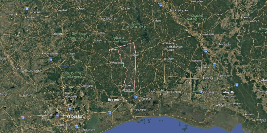
Jasper County is located in southeastern Texas within the Piney Woods region. It lies about 40 miles north of Beaumont and covers more than 900 square miles of forestland, rolling hills, and river valleys. The Neches River forms part of its western boundary, while the Angelina River runs along the east, framing much of the county’s geography.
Jasper, the county seat, sits near the center and serves as the hub for government, business, and community life. Smaller towns such as Kirbyville, Buna, and Evadale connect the surrounding rural areas. With its timber industry, rivers, and wooded terrain, Jasper County reflects the natural character of East Texas.
#20. Cochran County (tie)
– Life expectancy: 72.0 years
— 5.2 years lower than the state average
About
Cochran County’s story is rooted in the traditions of ranching and farming that brought settlers to the South Plains. Morton, the county seat, became the center of civic life, schools, and small-town commerce, helping connect scattered families across the flat landscape. Over time, the county has carried forward both its agricultural base and its frontier spirit.
Community pride shows in local events, church gatherings, and generational family ties that remain strong despite its wide, open spaces. The prairies and farmlands still define both work and identity, offering continuity through the years. Cochran County endures as a place where history, community, and land remain closely linked.
Where is Cochran County?

Cochran County is situated in far west Texas along the New Mexico border. It lies about 60 miles west of Lubbock and covers just over 770 square miles of High Plains terrain. The land is largely flat and semi-arid, supporting cotton farming, ranching, and oil production.
Morton, the county seat, sits near the center and serves as the hub for government and commerce. Smaller communities such as Whiteface and Bledsoe are scattered across the county, tied to agriculture and energy. With its wide-open plains, rural settlements, and resource-based economy, Cochran County reflects the character of the western South Plains.
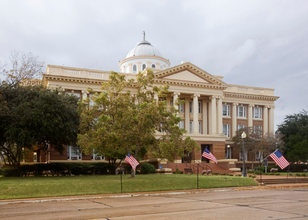
#19. Anderson County (tie)
– Life expectancy: 72.0 years
— 5.2 years lower than the state average
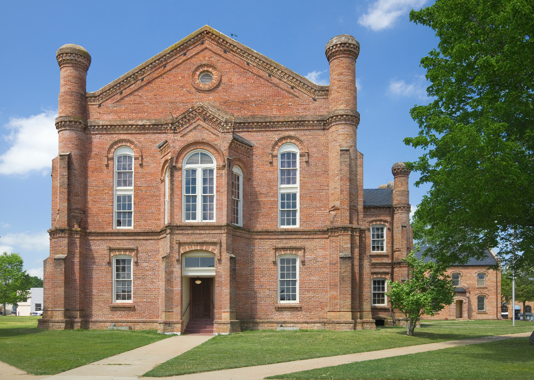
About
Anderson County carries a legacy tied to early settlement, farming, and the railroad that once connected its towns to broader markets. Palestine, the county seat, reflects this history through its historic architecture, cultural institutions, and role as a regional hub. The county’s identity blends its past with the steady traditions of East Texas life.
Forests, rolling hills, and fertile farmland form the landscape, supporting both agriculture and recreation. Community life thrives through festivals, music, and church-centered gatherings that preserve a strong sense of continuity. Anderson County endures as a place where history, land, and community remain firmly bound together.
Where is Anderson County?

Anderson County is located in east-central Texas, about 110 miles southeast of Dallas and 150 miles north of Houston. It covers more than 1,000 square miles of rolling hills, pine forests, and farmland within the East Texas region. The Trinity River flows along its western edge, shaping much of the county’s boundary and natural resources.
Palestine, the county seat, lies near the center and serves as the hub for government, commerce, and culture. Smaller communities such as Elkhart, Frankston, and Montalba are scattered across the countryside, connected by state highways. With its forests, farmland, and historic towns, Anderson County reflects the rural and cultural heritage of East Texas.
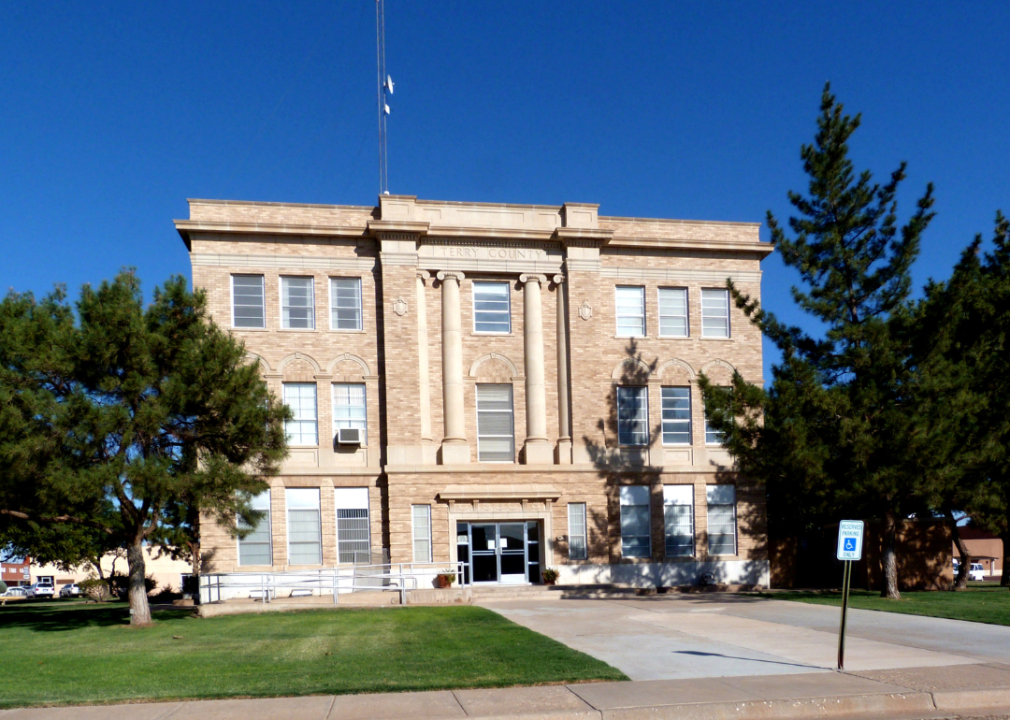
#18. Terry County
– Life expectancy: 71.9 years
— 5.3 years lower than the state average
About
Terry County rests on the South Plains of West Texas, where flat farmland and wide horizons shape both its economy and daily life. Brownfield, the county seat, anchors schools, commerce, and civic traditions, serving as the center for the region’s rural communities. The county’s identity reflects its agricultural foundation and the steady pace of small-town living.
Cotton farming has long been the backbone of the local economy, later joined by oil and energy development that reshaped growth. Festivals, sports traditions, and church gatherings keep community spirit alive across generations. Terry County stands as a place where land, history, and culture remain inseparably tied.
Where is Terry County?
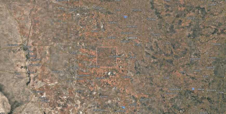
Terry County is located in west Texas within the South Plains region, about 40 miles southwest of Lubbock. It covers just under 900 square miles of flat High Plains terrain, where cotton farming, ranching, and oil production dominate the landscape. The county’s position along major farm-to-market roads ties it closely to surrounding agricultural areas.
Brownfield, the county seat, sits near the center and serves as the hub for government, business, and education. Smaller communities such as Meadow and Wellman support the surrounding farmland and rural residents. With its agricultural base, petroleum activity, and small-town centers, Terry County plays an important role in the South Plains.
#17. San Augustine County
– Life expectancy: 71.8 years
— 5.4 years lower than the state average
About
San Augustine County is one of Texas’s oldest counties, with roots reaching back to the Republic era and a heritage shaped by frontier settlement, farming, and timber. The county seat, San Augustine, reflects this legacy through historic landmarks, schools, and community traditions that anchor daily life.
Forests, streams, and rolling East Texas hills frame the landscape, supporting both agriculture and recreation, while church gatherings, festivals, and generational family ties sustain cultural identity. Together, land, history, and community give San Augustine County its enduring character.
Where is San Augustine County?
San Augustine County is located in eastern Texas within the Piney Woods region. It lies about 160 miles northeast of Houston and 40 miles east of Nacogdoches, covering just over 500 square miles of forested hills and farmland. The county’s eastern boundary runs along the Sam Rayburn Reservoir and the Angelina National Forest.
San Augustine, the county seat, sits near the center and serves as the hub for government and community life. Smaller communities such as Broaddus and Denning connect the surrounding rural areas to nearby lakes and forests. With its wooded landscape, historic roots, and access to outdoor recreation, San Augustine County reflects the character of East Texas.
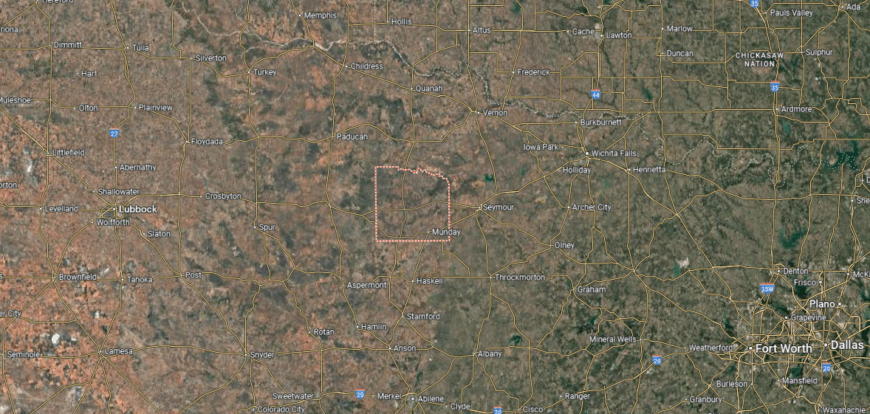
#16. Knox County
– Life expectancy: 71.7 years
— 5.5 years lower than the state average
You may also like: Best scenic drives in Texas
About
Knox County rests in North Texas, where open plains, ranchland, and the Brazos River shape both the scenery and daily life. Benjamin, the county seat, provides a small but steady center for schools, government, and community activity, while Munday contributes as a hub of local commerce. The county’s identity reflects the blend of rural landscape and the resilience of its people.
Ranching and farming have long supported the economy, and traditions built around fairs, sports, and church gatherings keep communities closely connected. Families often remain tied to the land for generations, carrying forward continuity through both work and heritage. Knox County stands as a place where geography, history, and community remain firmly interwoven.
Where is Knox County?
Knox County is located in north-central Texas, about 85 miles north of Abilene and 70 miles southwest of Wichita Falls. It spans more than 850 square miles of rolling plains, mesquite-covered rangeland, and cropland, much of it devoted to cattle ranching and wheat farming. The Brazos River runs along part of its southern boundary, shaping the county’s geography.
Benjamin, the county seat, sits near the center and serves as the hub for government and local services. Munday and Knox City are the county’s other main towns, each tied to farming and ranching activity. With its open landscapes, agricultural economy, and small-town centers, Knox County reflects the rural character of north-central Texas.
#15. Dallam County (tie)
– Life expectancy: 71.6 years
— 5.6 years lower than the state average
About
Dallam County’s story is tied to ranching and farming, which drew settlers to the far reaches of the Texas Panhandle. Dalhart, the county seat, developed as a hub for trade, schools, and civic life, connecting families across the wide, open plains. The county’s identity reflects both its frontier past and its continued reliance on agriculture.
Flat prairies and endless skies define the landscape, providing space for cattle, crops, and community traditions. Festivals, school events, and generational family ties keep local culture strong despite the county’s vast distances. Dallam County remains a place where history, land, and community are firmly bound together.
Where is Dallam County?

Dallam County is positioned in the far northwestern corner of Texas, forming part of the state’s Panhandle and touching both New Mexico and Oklahoma. It spans more than 1,500 square miles of High Plains terrain, with wide-open prairies, ranchland, and stretches of the Rita Blanca National Grasslands. The county lies about 85 miles northwest of Amarillo, making it one of the most remote in the state.
Dalhart, the county seat, sits near the intersection of U.S. Highways 54, 87, and 385 and serves as the hub for commerce and community life. Smaller communities such as Texline and Kerrick are scattered across the plains near the state borders. With its ranching base, expansive grasslands, and tri-state connections, Dallam County represents the far reaches of the Texas Panhandle.
#14. Donley County (tie)
– Life expectancy: 71.6 years
— 5.6 years lower than the state average
About
Donley County is shaped by its small-town gatherings, church events, and community traditions that connect families across the Texas Panhandle. Clarendon, the county seat, anchors schools, commerce, and civic activity, serving as the hub for surrounding ranching and farming areas. The county’s identity reflects both its rural heritage and its enduring community ties.
Its history is linked to ranching, farming, and the settlement of the Panhandle, which left a lasting imprint on its growth. Open plains and wide skies frame daily life, providing both livelihood and continuity for generations. Donley County endures as a place where culture, history, and land remain closely connected.
Where is Donley County?
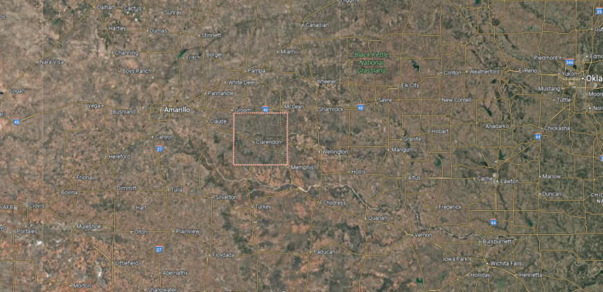
Donley County is located in the eastern Texas Panhandle, about 60 miles east of Amarillo. It covers just over 900 square miles of High Plains terrain, with rolling prairies, canyons, and the Prairie Dog Town Fork of the Red River shaping parts of the landscape. Agriculture, particularly cattle ranching and farming, has long been central to the county’s economy.
Clarendon, the county seat, lies near the center and serves as the hub for government, commerce, and education. Smaller communities such as Hedley and Howardwick connect the surrounding rural areas. With its mix of ranchlands, open plains, and historic towns, Donley County reflects the character of the Panhandle’s eastern edge.
#13. Hutchinson County
– Life expectancy: 71.4 years
— 5.8 years lower than the state average
About
Hutchinson County lies in the northern Panhandle, where prairies, rivers, and canyons shape its rugged setting. Borger, the county seat, serves as a hub for schools, commerce, and civic activity, connecting smaller communities across the region. The county’s identity reflects both its natural landscape and the energy of its industrial growth.
Its history is tied to the oil and gas boom, which transformed the area and left a lasting influence on its economy and culture. Community life thrives through festivals, school traditions, and local gatherings that strengthen bonds across generations. Hutchinson County remains a place where land, history, and community are firmly linked.
Where is Hutchinson County?

Hutchinson County is located in the northern Texas Panhandle, about 45 miles northeast of Amarillo. It spans over 880 square miles of High Plains terrain, marked by flat prairies, canyons, and stretches of the Canadian River that cut across its northern edge. Oil and natural gas development have played a central role in shaping the county’s economy and growth.
Stinnett, the county seat, sits near the middle of the county and serves as the hub for government and local services. Borger, the largest city, anchors the region’s commerce and industry, while smaller communities such as Fritch and Sanford provide additional local centers. With its combination of energy resources, open plains, and river valleys, Hutchinson County reflects the industrial and rural character of the Panhandle.
#12. Montague County (tie)
– Life expectancy: 71.3 years
— 5.9 years lower than the state average
About
Montague County’s story is tied to frontier settlement, ranching, and farming, which shaped its growth in North Texas. Montague, the county seat, and Bowie together serve as hubs for schools, commerce, and cultural life, linking smaller towns across the county. Its identity reflects both the endurance of rural traditions and the influence of regional trade.
Rolling hills, prairies, and farmland frame the land, providing space for ranches and community gatherings alike. Festivals, rodeos, and strong family networks sustain a sense of belonging across generations. Montague County continues to stand as a place where history, land, and culture remain firmly woven together.
Where is Montague County?
Montague County is found in north-central Texas along the Oklahoma border. It lies about 65 miles northwest of Fort Worth and 55 miles east of Wichita Falls, covering more than 930 square miles of rolling prairies, wooded hills, and farmland. The Red River defines much of its northern boundary, creating a natural border with Oklahoma.
Montague, the county seat, is located near the center and serves as the hub for government and community life. Bowie and Nocona are the largest towns, each tied to regional trade, ranching, and local industry. With its river border, mix of farmland and ranchland, and historic towns, Montague County represents the landscape and traditions of north-central Texas.
#11. Zavala County (tie)
– Life expectancy: 71.3 years
— 5.9 years lower than the state average
You may also like: Best private colleges in Texas
About
Zavala County is known for its strong community ties, where church gatherings, festivals, and school events highlight the rhythms of South Texas life. Crystal City, the county seat, serves as a hub for education, commerce, and civic activity, linking rural communities across the brush country. The county’s identity reflects both small-town traditions and a heritage rooted in Hispanic culture.
Its history includes ranching, farming, and a significant role in vegetable production, which gave Crystal City the title “Spinach Capital of the World.” The flat plains and fertile soil continue to support agriculture as a foundation for local life. Zavala County endures as a place where culture, land, and history remain inseparably connected.
Where is Zavala County?

Zavala County is located in South Texas, about 90 miles southwest of San Antonio and 35 miles east of the U.S.–Mexico border. It spans more than 1,300 square miles of brush country, farmland, and rangeland within the Rio Grande Plain. The Nueces River runs along part of its boundary, providing water for agriculture and wildlife.
Crystal City, the county seat, lies near the center and serves as the hub for government and community life. Smaller towns such as La Pryor and Batesville connect the surrounding rural areas and farming communities. With its agricultural base, ranchlands, and regional crossroads, Zavala County reflects the character of the South Texas brush country.
#10. Sabine County (tie)
– Life expectancy: 71.2 years
— 6.0 years lower than the state average
About
Sabine County lies along the eastern border of Texas, where forests, rivers, and the shores of Toledo Bend Reservoir shape both its setting and daily life. Hemphill, the county seat, anchors schools, commerce, and community traditions, serving as the center for surrounding rural areas. The county’s identity reflects its wooded landscape and its ties to the water.
Its history is rooted in early settlement, timber, and farming, industries that influenced growth for generations. Festivals, fishing tournaments, and family-centered gatherings keep heritage alive while strengthening community bonds. Sabine County remains a place where geography, history, and culture remain firmly connected.
Where is Sabine County?
Sabine County is located in far eastern Texas along the Louisiana border. It lies about 160 miles northeast of Houston and covers just over 500 square miles within the Piney Woods region. The county is bordered by the Sabine River and Toledo Bend Reservoir, which form its eastern edge and provide both recreation and natural resources.
Hemphill, the county seat, is positioned near the center and serves as the hub for government and community life. Smaller communities such as Pineland, Milam, and Geneva are scattered through the wooded countryside. With its forests, lakes, and border location, Sabine County reflects the natural and rural character of East Texas.
#9. Crockett County (tie)
– Life expectancy: 71.2 years
— 6.0 years lower than the state average
About
Crockett County carries a legacy tied to frontier settlement and the ranching traditions of West Texas. Ozona, the county seat, developed as a small but vital hub for schools, commerce, and community life in the midst of wide ranchlands. The county’s identity reflects both its historic resilience and its continuing ties to the land.
Its geography is marked by open plains, canyons, and the Pecos River, which shape both work and recreation. Community pride shows through local festivals, church gatherings, and family networks that pass traditions across generations. Crockett County endures as a place where history, land, and culture remain inseparably linked.
Where is Crockett County?
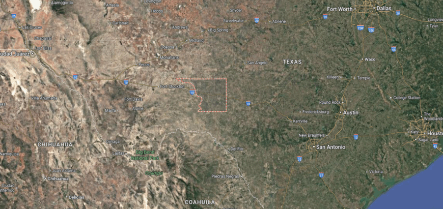
Crockett County is located in western Texas on the edge of the Edwards Plateau and the Trans-Pecos region. It spans more than 2,800 square miles, making it one of the larger counties in the state, with terrain that includes dry plains, rocky hills, and deep canyons carved by the Pecos River. The county lies about 200 miles west of San Antonio and 100 miles east of Fort Stockton, placing it in a remote but strategic position along Interstate 10.
Ozona, the county seat, is the only incorporated community and serves as the center for government, schools, and commerce. The rest of the county is largely rural, with ranches and open land stretching across wide distances. With its rugged landscape, river valleys, and crossroads location, Crockett County embodies the frontier character of West Texas.
#8. Potter County
– Life expectancy: 71.1 years
— 6.1 years lower than the state average
About
Potter County is shaped by the energy of its communities, where festivals, school events, and civic gatherings bring residents together across the Panhandle. Amarillo, the county seat, serves as a hub for education, commerce, and cultural life, tying the region’s towns and rural areas together. The county’s identity reflects both small-town traditions and the growth of a major urban center.
Its history includes ranching, railroads, and the rise of the cattle industry, each leaving a lasting mark on its development. Wide plains and open skies form the backdrop for daily life, while families and local institutions carry forward continuity across generations. Potter County stands as a place where culture, history, and land remain firmly bound.
Where is Potter County?
Potter County is located in the Texas Panhandle, about 120 miles north of Lubbock and bordering the Canadian River to the north. It covers nearly 900 square miles of High Plains terrain, with flat prairies, river breaks, and parts of Palo Duro Canyon cutting into its southern edge. The county’s location along Interstate 40 makes it a key stop on a major east–west travel corridor.
Amarillo, the county seat, lies near the center and serves as both the county’s largest city and the regional hub for business, culture, and transportation. Smaller communities such as Bishop Hills provide residential areas within the county’s borders. With its mix of urban development, canyon landscapes, and highway connections, Potter County anchors the northern Panhandle.
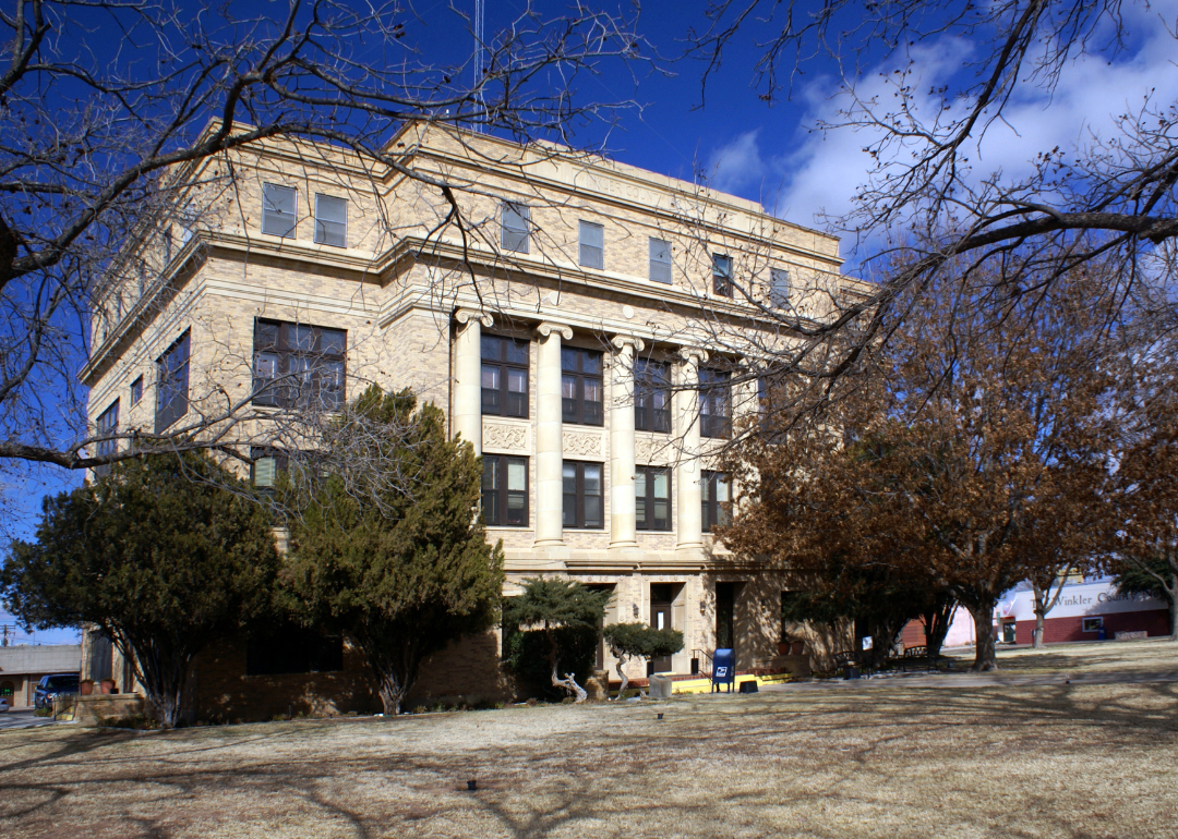
#7. Winkler County
– Life expectancy: 71.0 years
— 6.2 years lower than the state average
About
Winkler County lies in West Texas, where arid plains and desert brushland shape both its scenery and daily rhythms. Kermit, the county seat, provides the center for schools, commerce, and civic activity, connecting residents across the sparsely populated landscape. The county’s identity reflects both its rugged environment and its role in the state’s oil industry.
Its history is tied to ranching and the discovery of oil, which transformed the economy and remains a defining influence. Community life is sustained through local events, school traditions, and the strong ties of families rooted across generations. Winkler County continues to stand as a place where land, history, and community remain closely connected.
Where is Winkler County?
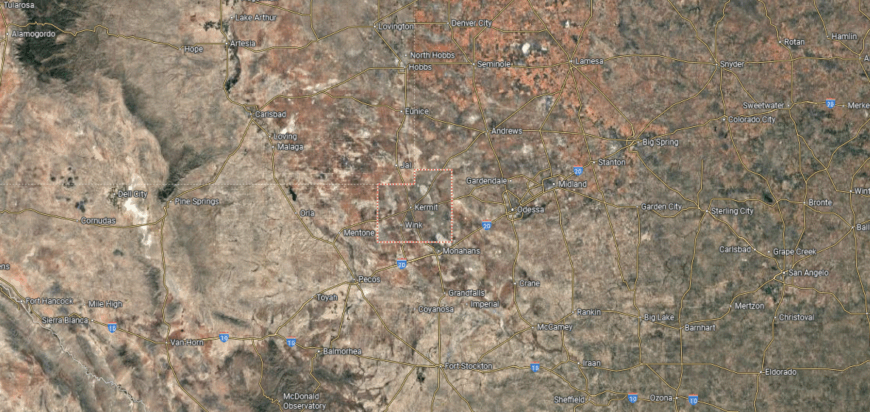
Winkler County is located in far western Texas within the Permian Basin. It spans just over 840 square miles of flat, semi-arid terrain, much of it devoted to oil production and ranching. The county lies about 35 miles southwest of Odessa and is crossed by several state highways that connect it to neighboring energy hubs.
Kermit, the county seat, sits near the center and serves as the hub for government, commerce, and community life. Wink, a smaller town, anchors the southern part of the county and is closely tied to the region’s oil history. With its petroleum industry, ranchlands, and rural towns, Winkler County reflects the resource-driven character of West Texas.
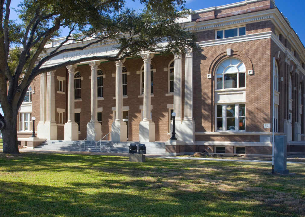
#6. Brooks County
– Life expectancy: 70.9 years
— 6.3 years lower than the state average
You may also like: How many people are receiving mental health treatment in Texas
About
Brooks County’s story is tied to ranching and the legacy of South Texas settlement, where wide stretches of brush country shaped both work and community life. Falfurrias, the county seat, developed as a hub for schools, commerce, and civic institutions, anchoring the region’s rural families. The county’s identity reflects resilience built from its ranching traditions and frontier roots.
Flat plains and brushland form the backdrop, supporting cattle and agriculture as steady parts of the economy. Festivals, church gatherings, and family networks preserve heritage and strengthen continuity across generations. Brooks County stands as a place where history, land, and culture remain firmly interwoven.
Where is Brooks County?
Brooks County is located in South Texas, about 70 miles north of the U.S.–Mexico border and 80 miles southwest of Corpus Christi. It spans more than 940 square miles of brush country, rangeland, and sandy soils typical of the Rio Grande Plain. The county is known for its remote setting and role as a crossroads along U.S. Highway 281.
Falfurrias, the county seat, lies near the center and serves as the hub for government, commerce, and community life. Smaller settlements and ranches are scattered throughout the countryside, tied to cattle raising and agriculture. With its rural landscape, borderland proximity, and ranching traditions, Brooks County reflects the character of South Texas.
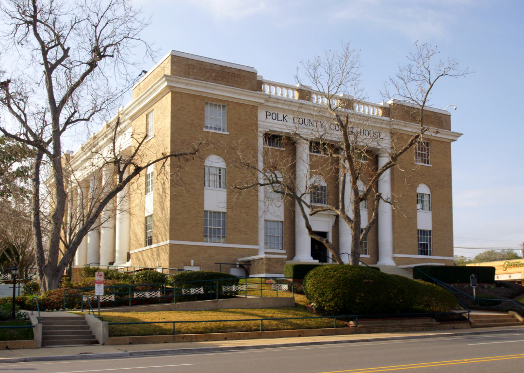
#5. Polk County
– Life expectancy: 70.8 years
— 6.4 years lower than the state average
About
Polk County is marked by strong community traditions, where church gatherings, school events, and festivals sustain the rhythms of East Texas life. Livingston, the county seat, serves as a hub for education, commerce, and civic activity, connecting nearby towns and rural areas. The county’s identity reflects both its small-town spirit and the heritage of the Piney Woods.
Its history is tied to timber, farming, and trade, which shaped settlement and growth across generations. Forests, rivers, and the presence of Lake Livingston provide both livelihood and recreation, grounding families in the land. Polk County endures as a place where culture, history, and geography remain firmly connected.
Where is Polk County?
Polk County is situated in southeastern Texas within the Piney Woods region. It lies about 75 miles northeast of Houston and covers more than 1,000 square miles of forestland, river valleys, and rolling hills. The Trinity River forms part of its western boundary, while Lake Livingston, one of the state’s largest reservoirs, dominates the center of the county.
Livingston, the county seat, sits near the lake and serves as the hub for government, business, and community life. Other towns such as Corrigan, Onalaska, and Goodrich connect the surrounding rural areas. With its wooded landscape, major reservoir, and small-town centers, Polk County reflects the natural and cultural character of East Texas.
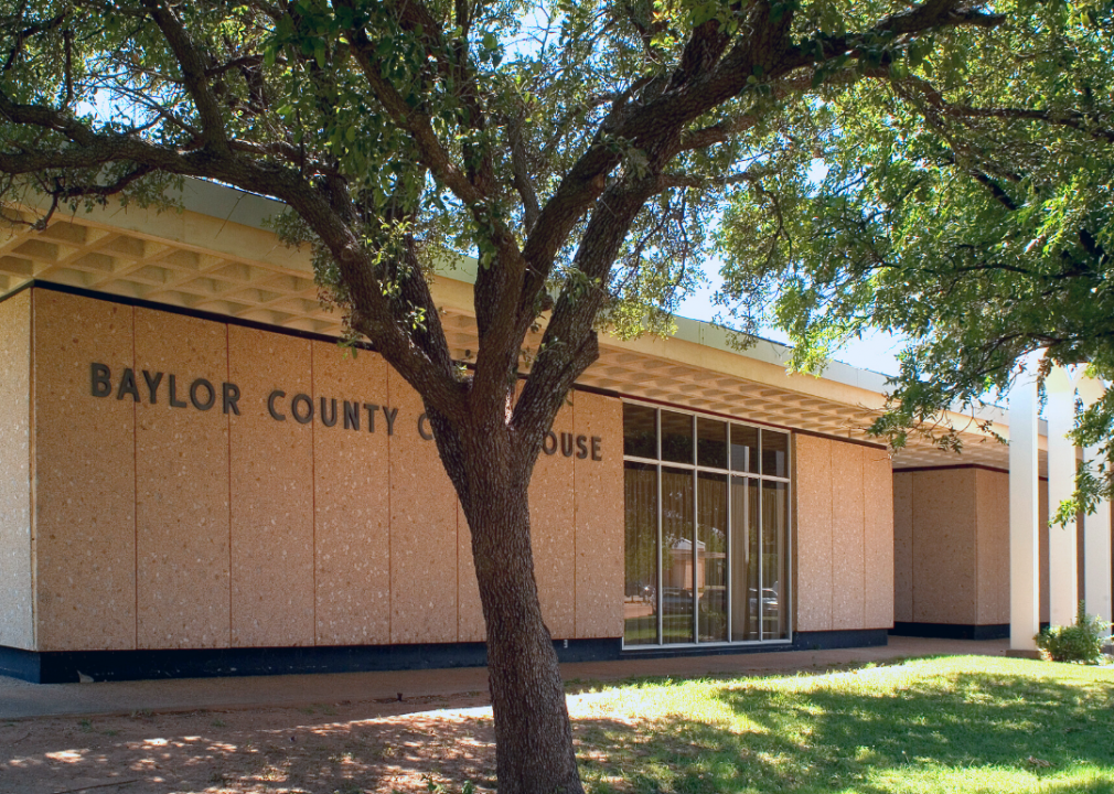
#4. Baylor County (tie)
– Life expectancy: 70.7 years
— 6.5 years lower than the state average
About
Baylor County lies in North Texas, where rolling prairies, farmland, and the Brazos River shape its landscape. Seymour, the county seat, anchors schools, commerce, and civic life, serving as a focal point for surrounding rural communities. The county’s identity reflects both its open land and its tradition of ranching and farming.
Its history includes frontier settlement, agriculture, and oil development, each leaving a lasting imprint on local life. Festivals, school events, and generational family ties help preserve continuity and pride across the county. Baylor County continues to stand as a place where land, history, and community remain firmly connected.
Where is Baylor County?

Baylor County is located in north-central Texas, about 130 miles northwest of Fort Worth and 50 miles southwest of Wichita Falls. It covers just over 900 square miles of rolling plains and mesquite-covered rangeland, much of it used for cattle ranching and farming. The Brazos River flows across part of the county, adding to its agricultural base.
Seymour, the county seat, rests near the center and serves as the hub for government, schools, and commerce. Smaller communities and rural settlements are scattered across the countryside, connected by U.S. Highways 82 and 277. With its ranchlands, open terrain, and river valleys, Baylor County reflects the rural traditions of north-central Texas.
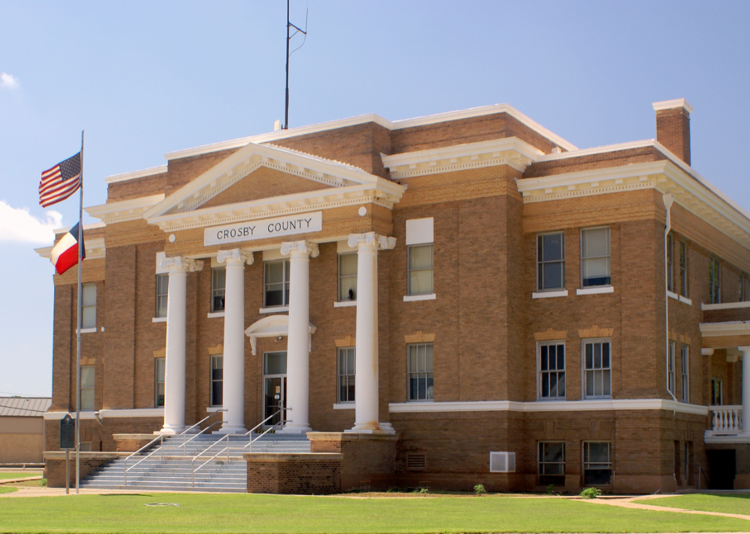
#3. Crosby County (tie)
– Life expectancy: 70.7 years
— 6.5 years lower than the state average
About
Crosby County carries a legacy shaped by frontier settlement, ranching, and the rise of farming on the South Plains. Crosbyton, the county seat, grew as a center for schools, commerce, and civic life, linking smaller rural communities across the wide, open landscape. The county’s identity reflects both its agricultural heritage and its enduring resilience.
Flat farmland and broad horizons define the scenery, providing the foundation for cotton and cattle as central parts of the economy. Festivals, school traditions, and family gatherings sustain community pride and continuity across generations. Crosby County remains a place where history, land, and culture are firmly bound together.
Where is Crosby County?
Crosby County is located in northwestern Texas within the South Plains region. It lies about 35 miles east of Lubbock and spans more than 900 square miles of High Plains terrain. The county’s geography includes flat farmland on the plains as well as steep canyons that mark the edge of the Caprock Escarpment.
Crosbyton, the county seat, sits near the center and serves as the hub for government and local commerce. Smaller communities such as Ralls and Lorenzo are tied to the area’s cotton farming and ranching economy. With its mix of open plains, canyonlands, and agricultural base, Crosby County reflects the landscape and traditions of the South Plains.
#2. Coleman County
– Life expectancy: 70.2 years
— 7.0 years lower than the state average
About
Coleman County is marked by its strong sense of community, where school events, church gatherings, and local celebrations bring people together across town and countryside. Coleman, the county seat, serves as a hub for education, commerce, and civic life, tying the area’s rural communities to a shared center. The county’s character blends small-town traditions with the steady values of West Texas living.
Its history is tied to ranching, farming, and frontier settlement, each leaving a lasting influence on the region’s growth. Rolling plains, lakes, and wide skies provide both livelihood and recreation for generations of families. Coleman County continues to stand as a place where culture, history, and land remain inseparably connected.
Where is Coleman County?
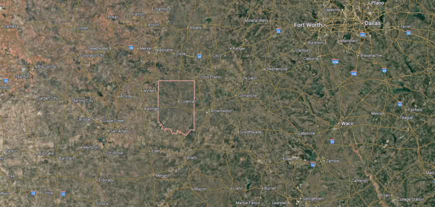
Coleman County is situated in central Texas, about 60 miles southeast of Abilene and 150 miles northwest of Austin. It covers just over 1,200 square miles of rolling plains, mesquite rangeland, and farmland, with the Colorado River forming part of its boundary. The county lies at the crossroads of West Texas ranch country and the northern Hill Country.
Coleman, the county seat, is located near the center and serves as the hub for government, commerce, and community life. Other small towns such as Santa Anna, Novice, and Valera connect the surrounding rural areas. With its blend of farmland, ranchlands, and river valleys, Coleman County reflects both the rugged and fertile character of central Texas.
#1. Red River County
– Life expectancy: 69.6 years
— 7.6 years lower than the state average
About
Red River County lies along the northeastern edge of Texas, its landscape defined by fertile bottomlands, forests, and the river that gives the county its name. Clarksville, the county seat, serves as a hub for schools, commerce, and civic life, anchoring smaller towns and rural communities. The county’s identity reflects the deep connection between land and settlement in this corner of East Texas.
Its history includes farming, timber, and trade, each shaping the growth and resilience of the county over generations. Festivals, church gatherings, and family traditions keep cultural ties strong and provide continuity across time. Red River County remains a place where geography, history, and community remain firmly linked.
Where is Red River County?

Red River County is located in far northeastern Texas along the Oklahoma border. It spans over 1,000 square miles of rolling prairies, farmland, and forests within the Piney Woods region. The Red River runs along its northern edge, creating a natural boundary and shaping much of the county’s history and economy.
Clarksville, the county seat, lies near the center and serves as the hub for government and commerce. Smaller communities such as Bogata, Detroit, and Annona connect the rural countryside with nearby trade routes. With its river frontage, agricultural base, and historic towns, Red River County reflects the heritage and landscape of northeast Texas.
This story features data reporting by Karim Noorani, writing by Kiersten Hickman, and is part of a series utilizing data automation across 49 states.
You may also like: Counties with the most prewar homes in Texas
By Stacker