
Counties with the shortest life expectancy in Oklahoma
Life expectancy can be affected by a variety of factors. About 25% of your lifespan is determined by genetics, according to the National Library of Medicine. Health and wellness habits—like following a balanced, nutrient-rich diet; not smoking; drinking minimal alcohol; maintaining a healthy weight; and staying physically active—can add more than a decade to your life, research from the National Institutes of Health shows. While these factors are significant, another important element that you might not have considered is your environment and community.
In order to come up with the very specific design ideas, we create most designs with the assistance of state-of-the-art AI interior design software.
While life expectancy generally increases annually in the United States—jumping from about 70.8 years old to 77.5 between 1970 and 2022, according to the Centers for Disease Control and Prevention—this particular metric can vary from state to state or even county to county. In some parts of the country, the average lifespan is getting shorter based on a variety of risk factors on top of health, including socioeconomic factors like poverty, unemployment, income, and education.
According to a 2020 study from researchers at Penn State, West Virginia, and Michigan State Universities, communities with a higher population density, more fast food restaurants, and a high number of extraction industry-based jobs tend to have shorter life expectancies.
To find out how life expectancy varies within Oklahoma, Stacker used 2024 County Health Rankings & Roadmaps from the University of Wisconsin Population Health Institute to identify the counties with the shortest life expectancy. Life expectancy measures the average number of years from birth a person can expect to live and is calculated based on the number of deaths in a given time period and the average number of people at risk of dying during that period. Counties with unreliable or insufficient data were excluded from the analysis. Mortality data came from the National Vital Statistics System.
Read on to see if your county is on the list.
You may also like: Seniors in these Oklahoma counties have the highest Alzheimer’s rates

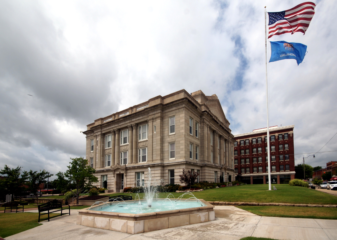
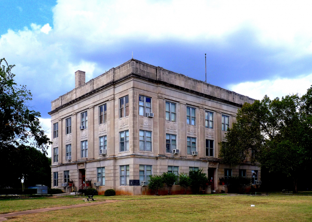
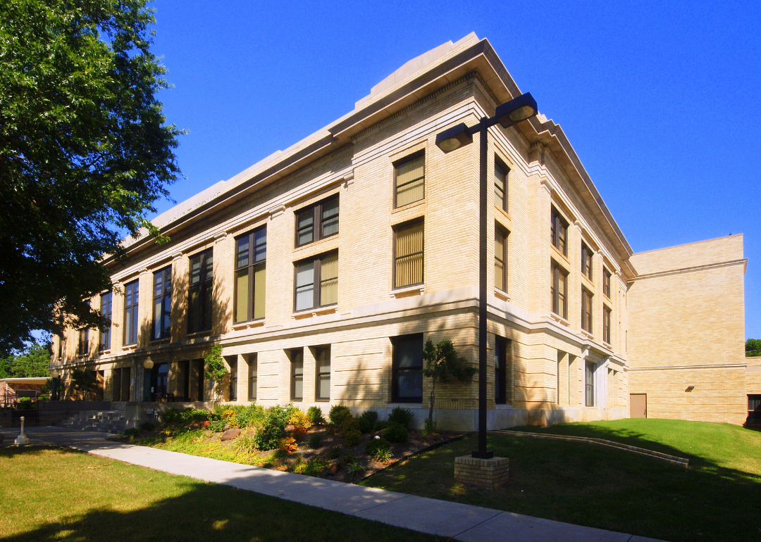
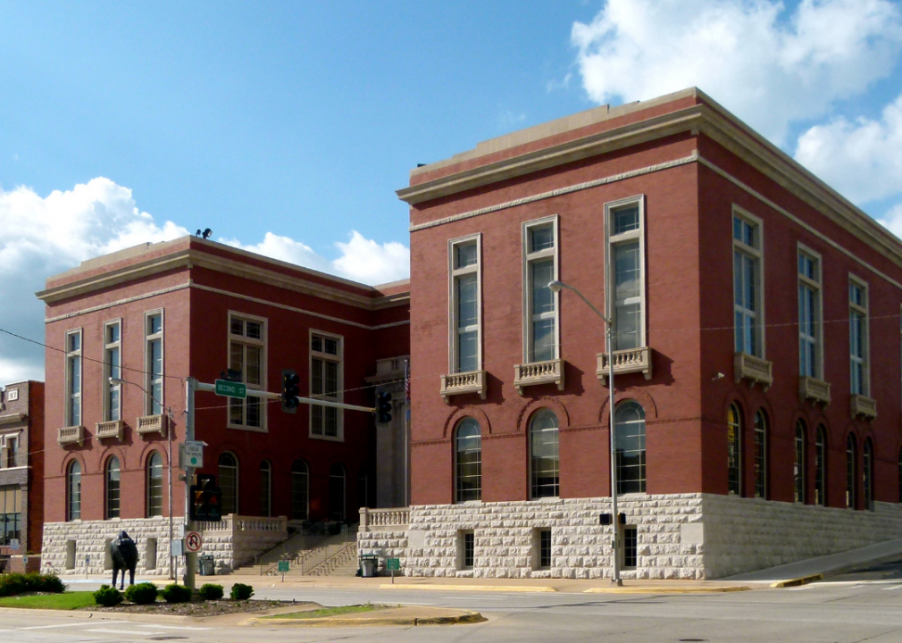
#38. Garfield County
– Life expectancy: 73.6 years
— 0.8 years lower than the state average
About
Garfield County, Oklahoma stretches across the open plains of north-central Oklahoma, where wide skies and fertile farmland define its landscape. Enid, the county seat, serves as both a regional hub and a cultural center, known for its arts scene, historic architecture, and role as a gathering place for surrounding communities. The land itself shapes much of the county’s rhythm, from wheat harvests to outdoor events.
Agriculture remains a pillar of the economy, but energy production, healthcare, and education now play equally important roles in supporting growth. Enid’s grain elevators, often called “the world’s tallest” when built, still stand as symbols of the county’s agricultural strength. Garfield County brings together the enduring productivity of its land with the adaptability of a modern regional center.
Where is Garfield County?
Garfield County lies in north-central Oklahoma, part of the Red Bed Plains that stretch across the state. It covers a landscape of wide prairies, productive farmland, and small creeks that flow into the Cimarron and Arkansas River systems. The county is positioned roughly 80 miles north of Oklahoma City, giving it strong links to the state’s capital region.
Enid is both the county seat and the largest city, long recognized as a center for grain storage and agricultural trade. Outlying towns such as Covington, Waukomis, and Kremlin add to the county’s small-town network. With major highways and rail lines crossing the area, Garfield County serves as an important agricultural and transportation hub in Oklahoma.
#37. Creek County (tie)
– Life expectancy: 73.5 years
— 0.9 years lower than the state average
About
Creek County, Oklahoma carries a name that reflects the legacy of the Muscogee (Creek) Nation, whose history and culture remain deeply tied to the region. Sapulpa, the county seat, developed as a stop along the rail lines and grew quickly with the oil boom of the early 20th century, leaving behind historic districts and industrial landmarks. Today, the county reflects both Native heritage and the story of Oklahoma’s energy-driven growth.
Oil and gas remain important to the economy, though manufacturing, transportation, and small businesses provide balance. Proximity to Tulsa has also encouraged suburban development while keeping much of the county’s rural identity intact. Creek County blends Native history, industrial heritage, and modern growth into a unique profile within eastern Oklahoma.
Where is Creek County?

Creek County is located in northeastern Oklahoma, just west of Tulsa. The county is named for the Muscogee (Creek) Nation, whose people were forcibly relocated to the area during the 19th century. Rolling hills, wooded ridges, and the Arkansas River shape much of the landscape, and the county sits at the crossroads of eastern woodlands and western prairies.
The county seat is Sapulpa, known for its glass manufacturing history and Route 66 heritage. Other communities include Bristow, Drumright, and Mannford, the latter of which lies along the shores of Keystone Lake — a popular spot for fishing, camping, and boating. Today, Creek County blends small-town character with its proximity to Tulsa, offering both rural charm and access to urban amenities.
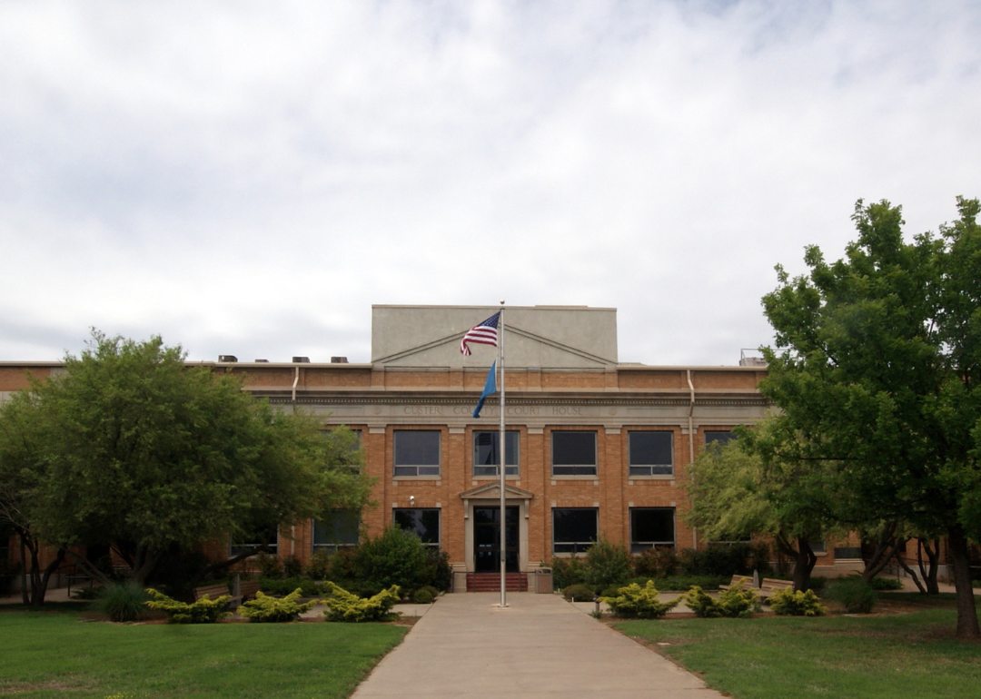
#36. Custer County (tie)
– Life expectancy: 73.5 years
— 0.9 years lower than the state average
About
Custer County, Oklahoma is anchored by Weatherford and Clinton, two towns that highlight the county’s mix of history, education, and Route 66 culture. Weatherford is home to Southwestern Oklahoma State University, giving the area an academic presence, while Clinton is celebrated for its role on the Mother Road, with museums and landmarks tied to America’s highway era. The county’s open plains and skies provide a setting that reflects the spirit of western Oklahoma.
Farming and ranching remain important, with wheat, cotton, and cattle forming the backbone of local production. Energy development, particularly wind power and oil, adds another layer to the economy, while tourism tied to Route 66 and regional history supports small businesses. Custer County stands out as a place where classic Americana, educational influence, and rural productivity intersect.
Where is Custer County?
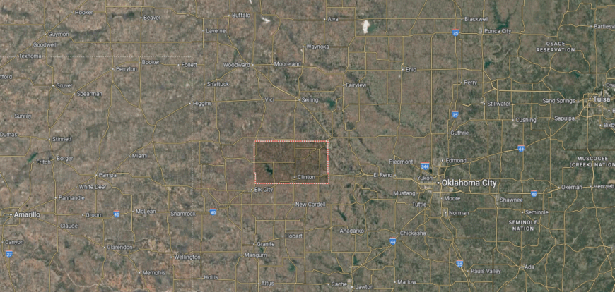
Custer County sits in western Oklahoma, where the rolling prairie opens into wide skies and wheat fields that stretch for miles. Established in 1891 and named after General George Armstrong Custer, the county has roots in both agricultural traditions and the growth of Route 66 communities that shaped much of Oklahoma’s identity in the 20th century.
Arapaho is the county seat, reflects the region’s deep ties to Native American and pioneer history, while nearby Clinton is known as the “Hub City of Western Oklahoma” and home to the Route 66 Museum. Weatherford, another key town, hosts Southwestern Oklahoma State University and attracts students from across the state. Together, these communities showcase Custer County’s balance of heritage, education, and prairie life.
#35. Craig County
– Life expectancy: 73.3 years
— 1.1 years lower than the state average

About
Craig County, Oklahoma sits in the state’s northeast corner, where rolling hills and open prairies stretch toward the Ozark Plateau. The county seat, Vinita, proudly claims the title “Crossroads of America,” a nod to its historic role as a railroad and highway junction. Travelers still stop at the famous Route 66 attraction—the world’s largest McDonald’s arches over the interstate here—as they pass through the region.
Beyond its roadside landmarks, Craig County has deep roots in Native American history, particularly with the Cherokee Nation, whose cultural presence remains strong. Agriculture, energy production, and small businesses sustain the local economy, while annual events like the Calf Fry Festival highlight the area’s rural traditions. This blend of history, community spirit, and Oklahoma landscape makes Craig County a distinctive part of “The Sooner State.”
Where is Craig County?
Craig County sits in the northeastern part of Oklahoma, where open prairies transition into the wooded foothills of the Ozark Plateau. Established at statehood in 1907, it was named for Granville Craig, a Cherokee farmer and political leader, reflecting the county’s strong Cherokee Nation heritage. The landscape is a mix of farmland, creeks, and gently rolling hills that support both agriculture and small communities.
Vinita serves as the county seat and is one of Oklahoma’s earliest towns, historically linked to the railroad and later to Route 66. Smaller towns such as Welch, Bluejacket, and Big Cabin add to the rural character of the area. With its blend of Native history, agricultural traditions, and transportation routes, Craig County connects Oklahoma’s past with its present.
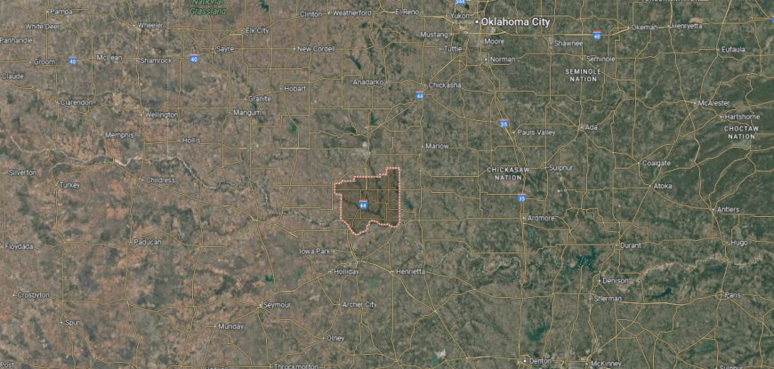
#34. Tillman County
– Life expectancy: 73.2 years
— 1.2 years lower than the state average
You may also like: States sending the most people to Oklahoma

About
Tillman County, Oklahoma lies in the state’s southwest corner, where broad prairies and open farmland define its landscape. Frederick, the county seat, grew as a rail and agricultural town, with grain elevators and depots marking its early importance. The county’s setting near the Red River connects it closely to both farming and cross-border trade with Texas.
Agriculture dominates the economy, with cotton, wheat, and cattle production long serving as the backbone of local life. Small industries, healthcare, and retail provide added support, helping sustain the rural population. Tillman County represents a place where the land itself shapes both livelihood and tradition, reflecting the enduring character of Oklahoma’s farm country.
Where is Tillman County?
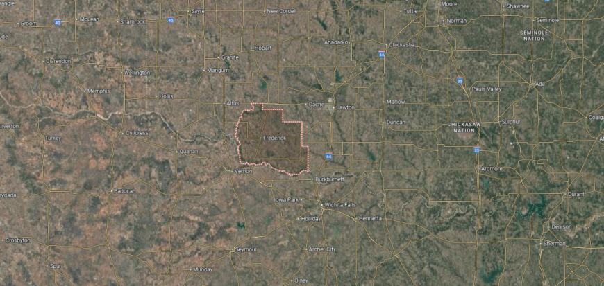
Tillman County, positioned along Oklahoma’s southern border, meets Texas at the Red River. Wide stretches of farmland dominate its landscape, with cotton, wheat, and cattle forming the backbone of the economy. Created in 1907 at statehood, the county reflects both pioneer settlement and the enduring agricultural traditions of the southwest plains.
At the center of the county sits Frederick, the seat of government and a hub for trade. Surrounding towns such as Tipton, Davidson, and Grandfield highlight the area’s rural character. Highways crossing north to south and east to west keep Tillman County tied to neighboring regions while preserving its prairie identity.
#33. Bryan County
– Life expectancy: 72.9 years
— 1.5 years lower than the state average
About
Bryan County, Oklahoma rests in the southeastern corner of the state, where the Red River forms its southern boundary and rolling hills give way to fertile valleys. Durant, the county seat, is known as the “Magnolia Capital of Oklahoma” and serves as both a cultural hub and home to Southeastern Oklahoma State University. The county also carries deep ties to the Choctaw Nation, whose government headquarters are located in Durant.
The economy is diverse, blending agriculture, education, and manufacturing with strong growth in retail and services. Tourism tied to Lake Texoma adds another important layer, drawing visitors for fishing, boating, and recreation. Bryan County reflects a balance of Native heritage, natural resources, and modern development that continues to shape its identity.
Where is Bryan County?
🔥 Would you like to save this?
Bryan County rests in southern Oklahoma, where the Red River marks the state line with Texas. The county was formed in 1907 at statehood and named after William Jennings Bryan, the three-time presidential candidate. Its geography is a mix of fertile bottomlands along the river and rolling prairies that extend northward.
The county seat, Durant, has grown into a regional center for business, education, and culture, also serving as the home of Southeastern Oklahoma State University. Calera, Caddo, and Colbert are smaller towns that reflect the county’s agricultural and transportation roots. With U.S. Highway 69/75 running through, Bryan County connects North Texas to the rest of Oklahoma while maintaining its own strong community identity.
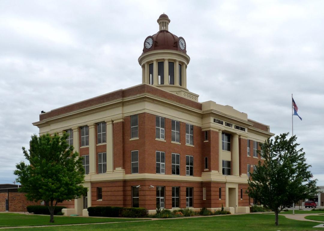
#32. Beckham County (tie)
– Life expectancy: 72.6 years
— 1.8 years lower than the state average
About
Beckham County, Oklahoma rises from the western plains, where wide horizons and red soil shape both its landscape and identity. Sayre, the county seat, and Elk City, its largest town, reflect the county’s ties to Route 66, with museums and landmarks honoring the highway’s history. The Beckham County Courthouse, with its distinctive dome, stands as a regional landmark and symbol of civic life.
Agriculture—especially cattle and wheat—anchors the economy, while oil and gas production add significant influence. Tourism connected to Route 66, along with local businesses and services, supports steady growth. Beckham County embodies the character of western Oklahoma, where land, history, and resilience converge.
Where is Beckham County?
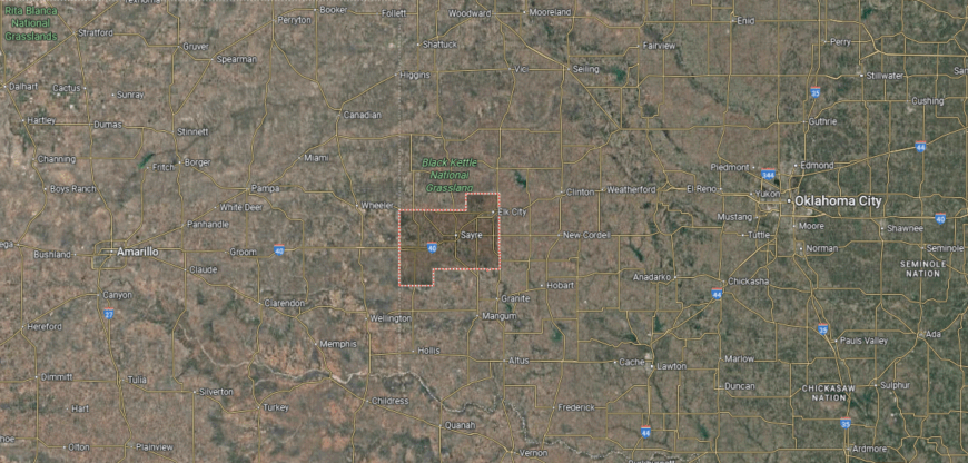
Beckham County is positioned in far western Oklahoma, directly along the state’s border with the Texas Panhandle. It sits about 130 miles west of Oklahoma City and roughly 150 miles east of Amarillo, Texas. The county’s landscape is shaped by the Red River system and stretches of prairie that dominate the region.
Sayre, the county seat, lies near the center along Interstate 40, a major east–west route. Elk City is located to the northeast and serves as the largest urban center in the county. Smaller towns such as Erick and Carter are spread across the western plains, close to the Texas state line.
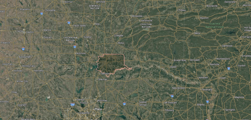
#31. Murray County (tie)
– Life expectancy: 72.6 years
— 1.8 years lower than the state average
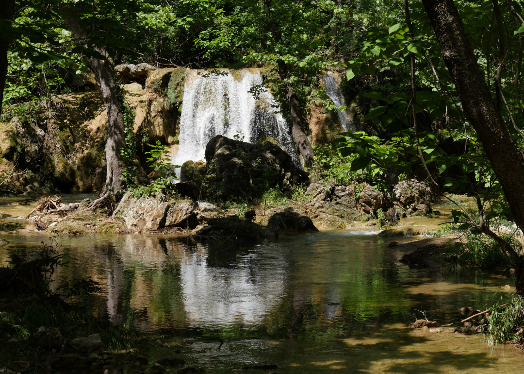
About
Murray County, Oklahoma is nestled in the Arbuckle Mountains, giving it one of the most scenic landscapes in the state. Sulphur, the county seat, is closely tied to Chickasaw National Recreation Area, where natural springs, lakes, and trails draw visitors year-round. The county’s mix of rugged hills, clear waters, and historic sites makes it a unique destination within south-central Oklahoma.
Tourism is a major economic driver, supported by the recreation area, Turner Falls, and cultural attractions linked to the Chickasaw Nation. Agriculture and small businesses provide additional stability, while hospitality and services benefit from steady visitor traffic. Murray County stands out as a place where natural beauty, Native heritage, and community life are deeply connected.
Where is Murray County?
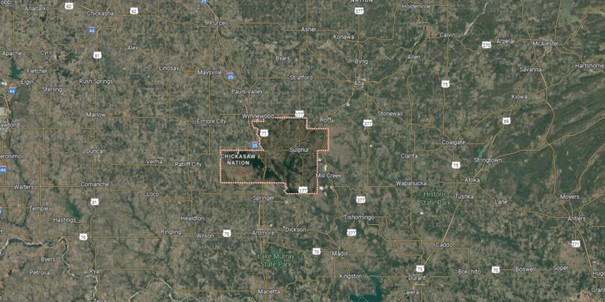
Murray County sits in south-central Oklahoma, bordered by Garvin County to the north and Carter County to the south. It lies about 75 miles south of Oklahoma City and roughly 30 miles north of the Red River, placing it within the Arbuckle Mountains region. The area is noted for its mix of rugged hills, springs, and fertile valleys.
Sulphur, the county seat, is located near the center and serves as the gateway to the Chickasaw National Recreation Area. Davis lies just to the west along Interstate 35, connecting the county to major travel routes. Smaller communities such as Dougherty and Hickory are scattered across the Arbuckle foothills.
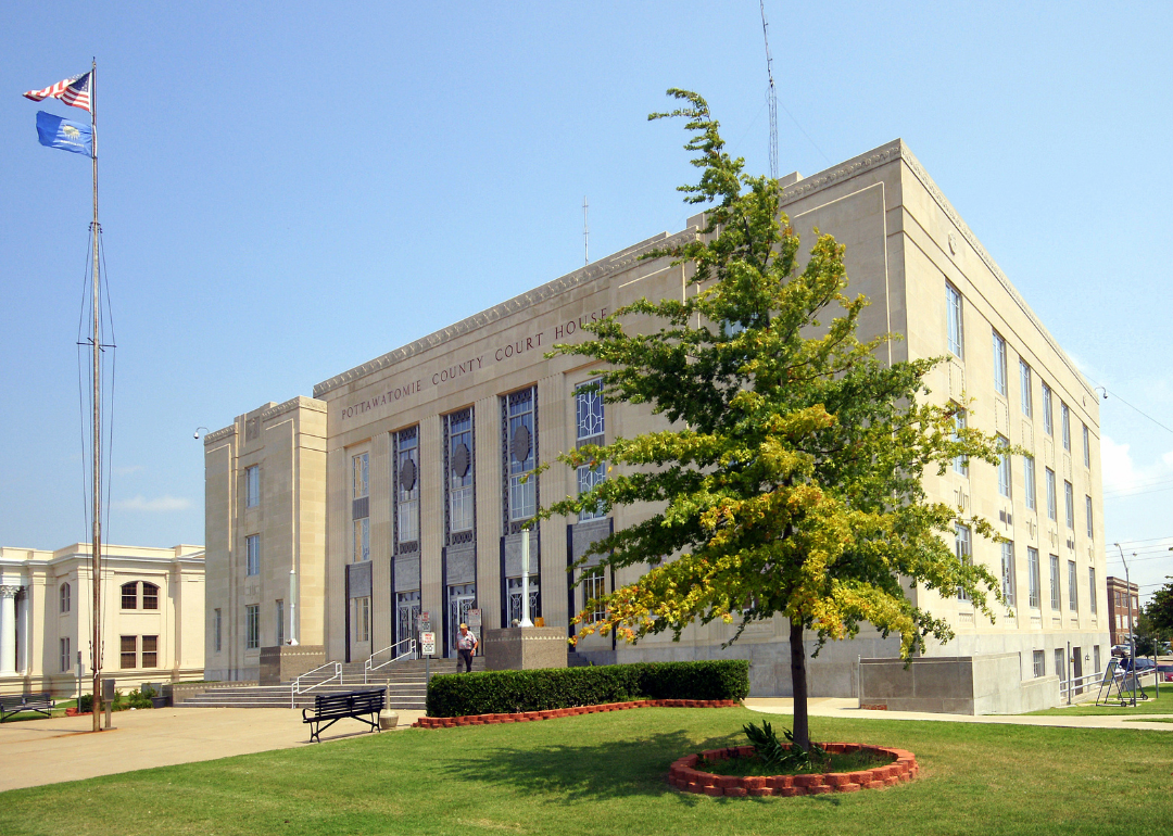
#30. Pottawatomie County (tie)
– Life expectancy: 72.5 years
— 1.9 years lower than the state average

About
Pottawatomie County, Oklahoma blends Native heritage, agricultural tradition, and modern development in the heart of the state. Shawnee, the county seat, reflects this mix with historic districts, cultural institutions, and a role as a regional center for commerce and education. The county’s roots tie back to the Potawatomi people, whose influence remains visible in local communities and traditions.
Agriculture has long shaped the economy, with crops and livestock anchoring rural life, but manufacturing, healthcare, and retail now provide significant strength. Educational institutions and cultural venues add to the county’s character, while casinos and tribal enterprises highlight its Native connections. Pottawatomie County represents a balance of history, economy, and cultural identity that continues to evolve.
Where is Pottawatomie County?
Pottawatomie County is located in central Oklahoma, east of Oklahoma County and west of Seminole County. It sits about 40 miles east of Oklahoma City, with the North Canadian River flowing across its northern boundary. The county’s terrain combines fertile river bottomlands with rolling prairies.
Shawnee, the county seat, lies along Interstate 40 and serves as the largest community in the area. Tecumseh sits just south of Shawnee, while smaller towns such as Asher, Earlsboro, and Maud add to the county’s rural makeup. With its location near the state capital, Pottawatomie County links central Oklahoma to both eastern and southern regions of the state.
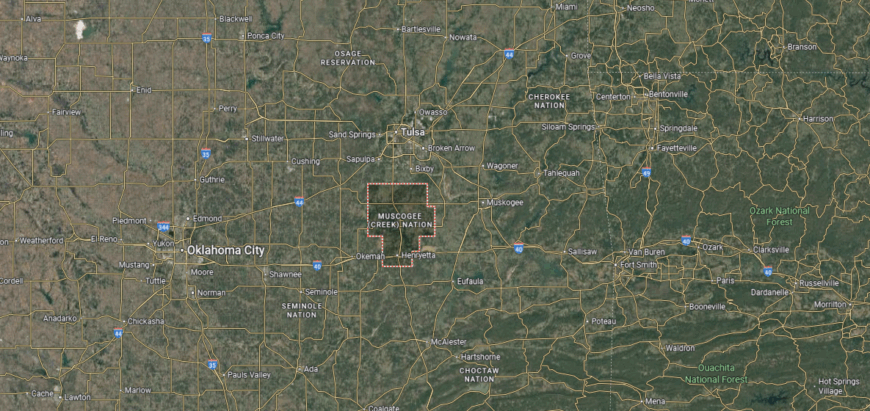
#29. McIntosh County (tie)
– Life expectancy: 72.5 years
— 1.9 years lower than the state average
You may also like: How many people are receiving mental health treatment in Oklahoma
About
McIntosh County, Oklahoma is shaped by its waters, with Lake Eufaula—the largest lake in the state—dominating its landscape and defining much of its identity. Checotah, the county seat, is known as the “Steer Wrestling Capital of the World” and carries a strong country music tradition, being the hometown of singer Carrie Underwood. The blend of lakefront life, small towns, and open countryside gives the county a distinctive character.
Tourism tied to Lake Eufaula plays a major role in the economy, drawing boaters, campers, and anglers throughout the year. Agriculture remains important, with cattle and crops supporting rural communities, while retail and services sustain local needs. McIntosh County combines water-centered recreation, cultural heritage, and farming traditions into a lasting and recognizable identity.
Where is McIntosh County?
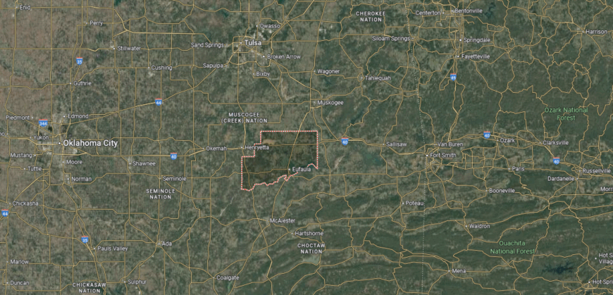
McIntosh County lies in eastern Oklahoma, bordered by Muskogee County to the north and Pittsburg County to the south. It is positioned along Lake Eufaula, one of the largest reservoirs in the United States, which covers much of its western side. The county’s landscape blends rolling hills, wooded areas, and wide stretches of water.
Eufaula serves as the county seat and sits near the lake’s shoreline. Other communities include Checotah to the northeast and Stidham to the south. With U.S. Highways 69 and 266 crossing the area, McIntosh County is well connected to Tulsa and southeastern Oklahoma.
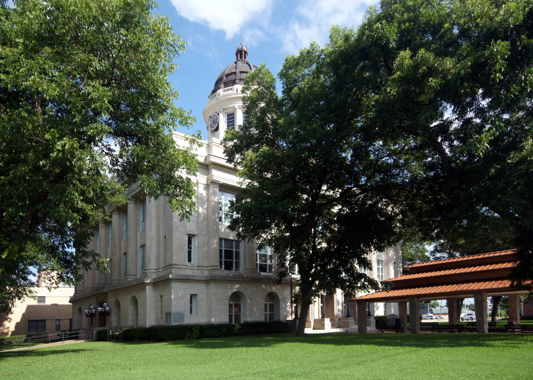
#28. Carter County
– Life expectancy: 72.4 years
— 2.0 years lower than the state average
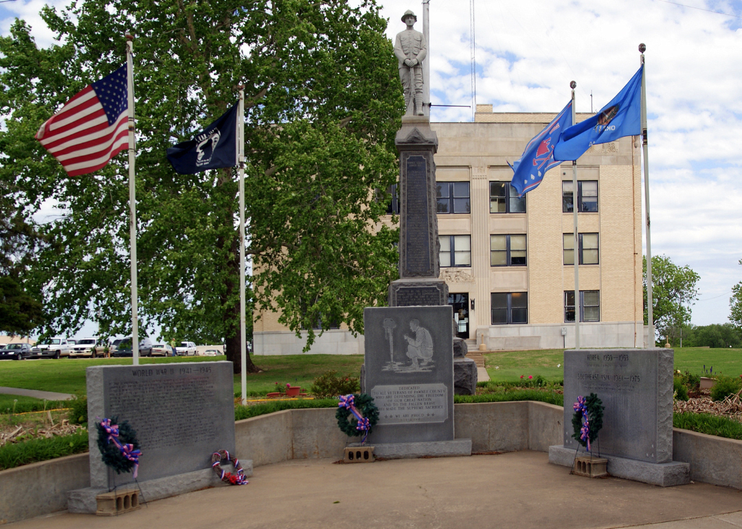
About
Carter County, Oklahoma sits in the southern part of the state, where rolling plains meet wooded hills and creeks. Ardmore, the county seat, grew as a railroad and oil town, carrying a history shaped by both opportunity and resilience after major fires and explosions in its early years. Today, its historic downtown and cultural institutions highlight the county’s role as a regional hub.
Oil and natural gas continue to influence the economy, but Carter County also benefits from manufacturing, healthcare, and retail. Agriculture remains part of daily life, with cattle and crops anchoring rural communities, while tourism tied to Lake Murray and regional history adds diversity. Carter County reflects a balance of energy heritage, economic growth, and community strength.
Where is Carter County?
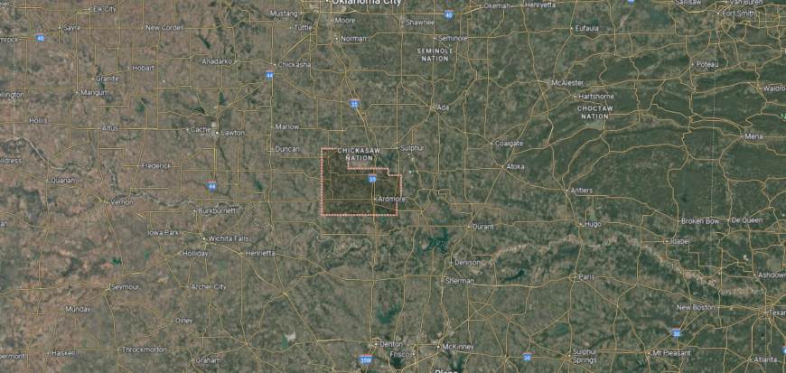
Carter County is located in south-central Oklahoma, bordered by Murray County to the north and Love County to the south. It sits about 100 miles south of Oklahoma City and roughly 30 miles north of the Red River, which separates Oklahoma from Texas. The terrain includes rolling prairies, wooded hills, and parts of the Arbuckle Mountains.
Ardmore serves as the county seat and is the largest community, positioned along Interstate 35 between Oklahoma City and Dallas. Smaller towns such as Wilson, Lone Grove, and Healdton add to the county’s local network. With its central location on major travel routes, Carter County connects southern Oklahoma to the Texas border region.
#27. Pawnee County (tie)
– Life expectancy: 72.3 years
— 2.1 years lower than the state average
About
Pawnee County, Oklahoma carries a strong Native heritage, with the Pawnee Nation headquarters located in the town of Pawnee, the county seat. Historic sites such as the Pawnee Bill Ranch and Museum highlight both Native and frontier history, tying the county to Oklahoma’s cultural story. Its landscape of prairies, rolling hills, and reservoirs shapes both recreation and rural life.
Agriculture has long supported the county, with cattle and crops forming its foundation, while energy production—particularly oil and gas—has added economic influence. Tourism tied to history, rodeos, and outdoor spaces provides another layer of vitality. Pawnee County blends Native identity, agricultural tradition, and historic preservation into a distinctive profile within the state.
Where is Pawnee County?
🔥 Would you like to save this?
Pawnee County sits in north-central Oklahoma, bordered by Osage County to the north and Creek County to the south. It lies about 50 miles west of Tulsa, with the Arkansas River forming part of its southern boundary. The county’s landscape is made up of rolling prairies, wooded hills, and reservoirs that support both farming and recreation.
Pawnee, the county seat, is located near the middle of the county and reflects both pioneer and Native American heritage. Cleveland, on the eastern side, sits along Keystone Lake and serves as a gateway to water recreation. Other communities such as Hallett, Jennings, and Maramec contribute to the county’s rural makeup.
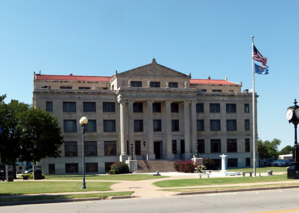
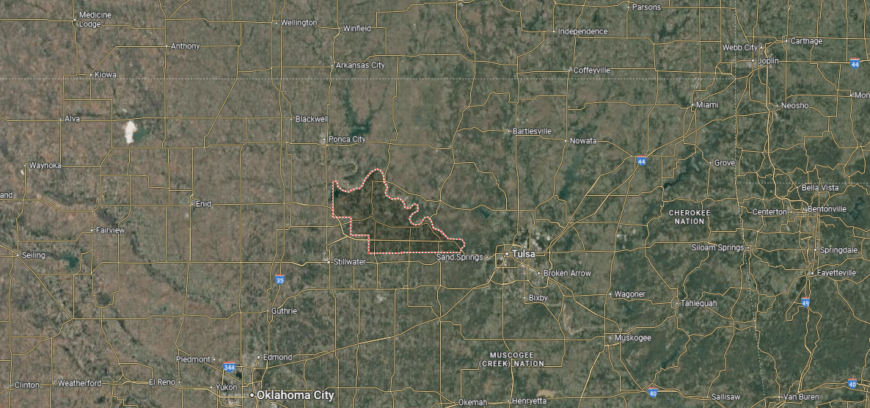
#26. Kay County (tie)
– Life expectancy: 72.3 years
— 2.1 years lower than the state average

About
Kay County, Oklahoma is positioned along the state’s northern border, where the Arkansas River and wide plains shape its landscape. Ponca City, the county seat, rose to prominence during the oil boom of the early 20th century, leaving behind architectural landmarks like the Marland Mansion that still showcase that era’s prosperity. Smaller towns contribute their own history and character, reflecting both Native and pioneer influences.
Oil remains part of the county’s economic story, but modern life is supported by agriculture, manufacturing, healthcare, and education. Energy companies, refineries, and agribusiness provide a strong foundation, while tourism tied to history and cultural attractions adds vitality. Kay County reflects a mix of oil heritage, rural productivity, and modern adaptability.
Where is Kay County?
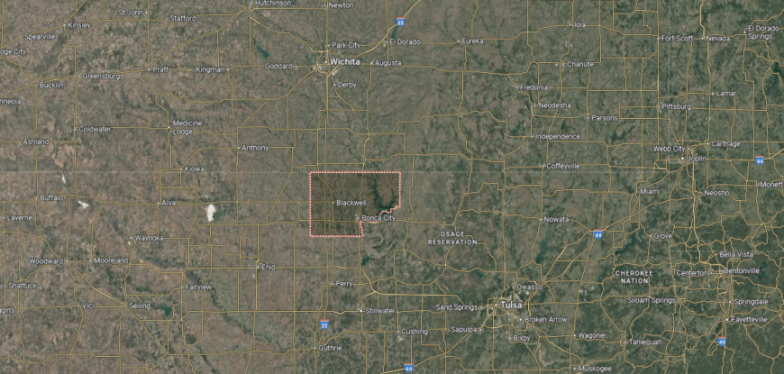
Kay County is positioned in north-central Oklahoma, bordering Kansas to the north and Noble County to the south. It lies about 90 miles north of Oklahoma City and is crossed by the Arkansas River, which flows eastward through the county. The terrain includes fertile farmland, prairies, and oil-rich lands that have shaped its economy.
Newkirk serves as the county seat, located near the Kansas state line. Ponca City is the largest community, historically tied to the oil industry and still a major center of commerce. Smaller towns such as Tonkawa, Blackwell, and Kaw City add to the county’s local network, with Kaw Lake providing recreation and water resources.
#25. Mayes County (tie)
– Life expectancy: 72.3 years
— 2.1 years lower than the state average

About
Mayes County, Oklahoma lies in the northeastern part of the state, where the Grand River and surrounding lakes shape both its scenery and daily life. Pryor Creek, the county seat, serves as a hub for business and culture, with historic downtown streets that reflect the town’s early growth. The county is also home to the massive MidAmerica Industrial Park, one of the largest of its kind in the nation.
The economy is anchored by this industrial park, which supports manufacturing, technology, and energy-related industries, while agriculture remains vital across rural areas. Lake Hudson and nearby recreational areas attract visitors for boating, fishing, and outdoor activities, strengthening tourism. Mayes County stands out as a place where industry, natural resources, and community traditions intersect.
Where is Mayes County?

Mayes County lies in northeastern Oklahoma, bordered by Rogers County to the west and Delaware County to the east. It is about 45 miles east of Tulsa, with the Grand River and its system of lakes — including Lake Hudson and Grand Lake O’ the Cherokees — shaping much of the county’s geography. Rolling hills, fertile valleys, and waterways define its landscape.
Pryor Creek, often called Pryor, serves as the county seat and is positioned near the center of the county. Salina, Locust Grove, and Chouteau are other key towns, each tied to agriculture, trade, or recreation. With U.S. Highway 69 and the MidAmerica Industrial Park, Mayes County connects small-town life with major economic development.
#24. Pontotoc County (tie)
– Life expectancy: 72.3 years
— 2.1 years lower than the state average
You may also like: Bestselling cars in Oklahoma
About
Pontotoc County, Oklahoma is located in the rolling hills of south-central Oklahoma, with Ada serving as its county seat and cultural center. The city is home to East Central University, which provides academic and cultural influence, and it also hosts the Chickasaw Nation headquarters, adding deep Native heritage to the county’s identity. Landmarks, museums, and local events highlight the area’s mix of history and community life.
The economy reflects this diversity—education, tribal enterprises, healthcare, and manufacturing support much of the workforce. Agriculture remains important in the surrounding areas, with cattle and crops anchoring rural communities. Pontotoc County blends Native heritage, educational strength, and rural tradition into a profile that continues to evolve.
Where is Pontotoc County?
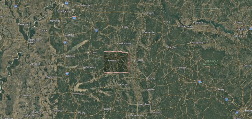
Pontotoc County is situated in south-central Oklahoma, bordered by Seminole County to the north and Johnston County to the south. It lies about 85 miles southeast of Oklahoma City and sits within a landscape of rolling prairies, river valleys, and wooded hills. The county is crossed by the Canadian and Blue rivers, which add to its agricultural and natural resources.
Ada serves as the county seat and is the largest community, home to East Central University and the headquarters of the Chickasaw Nation. Other towns such as Roff, Stonewall, and Byng contribute to the county’s rural network. With state highways linking it to larger cities, Pontotoc County balances small-town life with cultural and educational significance.
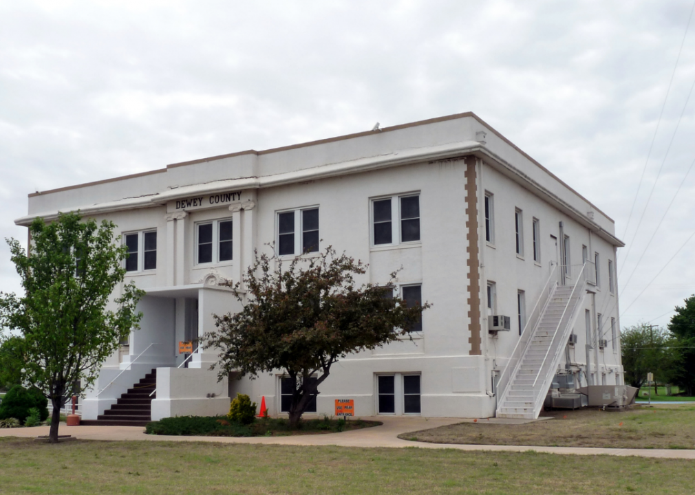
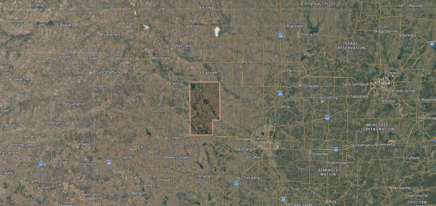
#23. Dewey County (tie)
– Life expectancy: 72.3 years
— 2.1 years lower than the state average

About
Dewey County, Oklahoma lies in the western part of the state, where open prairies and red soil form the backdrop of daily life. Taloga, the county seat, reflects the quiet character of a rural community, while surrounding towns carry histories tied to early settlement and farming. The Canadian River and wide skies give the county a landscape that feels distinctly western.
Agriculture remains central, with wheat, cattle, and other livestock forming the backbone of the local economy. Oil and wind energy add modern layers of development, providing new opportunities alongside traditional farming. Dewey County represents the resilience of Oklahoma’s plains, where land and resourcefulness continue to shape identity.
Where is Dewey County?
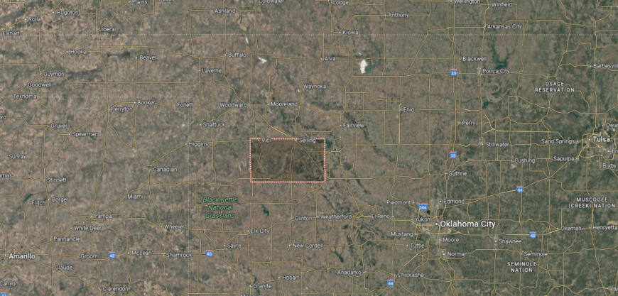
Dewey County sits in western Oklahoma, bordered by Woodward County to the north and Custer County to the south. It lies about 120 miles northwest of Oklahoma City, in a region defined by prairies, red soil, and the Canadian River flowing across its southern boundary. The landscape reflects both open farmland and rugged terrain typical of the western plains.
Taloga is the county seat, located near the center along the North Canadian River valley. Other communities such as Seiling, Vici, and Camargo serve as small hubs for agriculture and local trade. With U.S. Highways 183 and 270 crossing the county, Dewey maintains strong connections to surrounding regions.
#22. Haskell County
– Life expectancy: 72.2 years
— 2.2 years lower than the state average
🔥 Would you like to save this?
About
Haskell County, Oklahoma rests in the state’s eastern hills, where forests, rivers, and farmland create a varied landscape. Stigler, the county seat, reflects both small-town traditions and the county’s ties to Native history, as much of the land was once part of the Choctaw Nation. Historic sites, churches, and community events highlight its cultural roots.
Agriculture plays a strong role in the economy, with cattle, poultry, and crops supporting rural life. Coal mining was once significant here, and while it has declined, energy and small industries continue to contribute. Haskell County blends Native heritage, agricultural strength, and historic character into a profile shaped by both land and legacy.
Where is Haskell County?
Haskell County lies in eastern Oklahoma, bordered by Muskogee County to the north and Latimer County to the south. It is positioned about 40 miles west of the Arkansas state line, with the San Bois Mountains rising in its southern portion and the Arkansas River forming part of its northern edge. The landscape combines river bottomlands, rolling hills, and forested ridges.
Stigler serves as the county seat and is centrally located, acting as the hub for government and commerce. Other towns include Keota, McCurtain, and Kinta, each tied to the county’s agricultural and coal-mining heritage. With state highways and its proximity to Kerr Lake and the Arkansas River, Haskell County links natural resources with regional trade and recreation.
#21. Cotton County (tie)
– Life expectancy: 72.1 years
— 2.3 years lower than the state average
About
Cotton County, Oklahoma sits along the Red River in the state’s southern plains, its name reflecting the crop that shaped much of its early history. Walters, the county seat, grew as a farming and trade town, with historic streets and civic institutions still anchoring community life. Open farmland and river valleys define the county’s landscape, tying it closely to agriculture.
Cotton production, along with wheat, cattle, and other livestock, continues to drive the local economy. Small industries, energy development, and local services add stability, supporting the rural population. Cotton County represents a place where farming heritage, natural resources, and community traditions remain closely connected.
Where is Cotton County?
Cotton County is located in southern Oklahoma, sharing its border with Texas along the Red River. It was created in 1912, making it one of the last counties formed in the state, and its landscape consists of open prairie, farmland, and river valleys. The county sits about 90 miles southwest of Oklahoma City and 30 miles north of Wichita Falls, Texas.
Walters serves as the county seat and is positioned near the center of the county. Other towns such as Temple, Randlett, and Devol contribute to the area’s rural character. With U.S. Highway 277 and access to Interstate 44, Cotton County maintains strong connections to both Oklahoma and northern Texas.
#20. Harmon County (tie)
– Life expectancy: 72.1 years
— 2.3 years lower than the state average
About
Harmon County, Oklahoma lies in the state’s southwest corner, bordered by Texas and shaped by wide prairies and open skies. Hollis, the county seat, reflects the spirit of a small agricultural town, with schools, churches, and historic buildings serving as community landmarks. The Red River valley adds both natural beauty and fertile ground to the county’s character.
Agriculture is the backbone of the economy, with cotton, wheat, and cattle production sustaining local life. Small businesses and services provide support, while regional trade ties the county to neighboring areas in Texas and Oklahoma. Harmon County endures as a rural landscape where farming traditions and wide-open land define its identity.
Where is Harmon County?
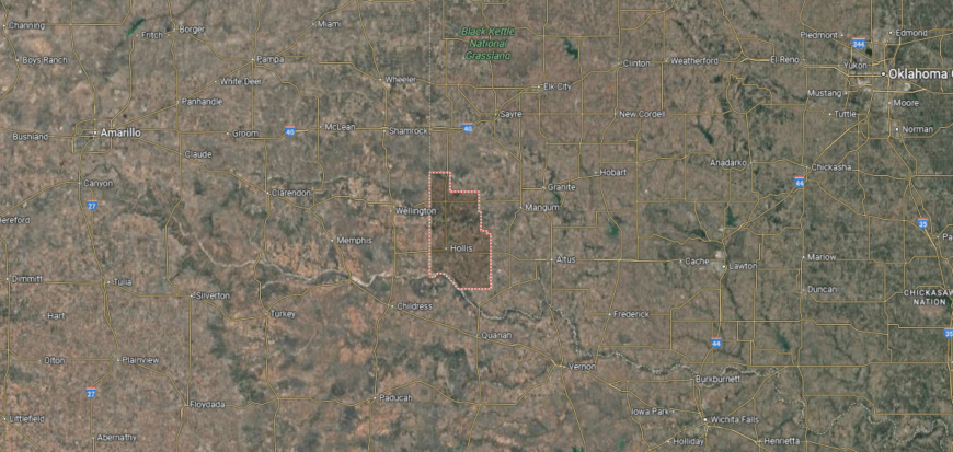
Harmon County is positioned in the far southwestern corner of Oklahoma, with Texas forming both its southern and western boundaries. It was established in 1909 and is one of the least populated counties in the state. The terrain consists largely of flat plains and fertile farmland, especially along the Red River.
Hollis serves as the county seat and is located near the Texas state line. Other communities such as Gould and Vinson reflect the county’s agricultural roots and small-town lifestyle. Highways crossing the area connect Harmon County to larger trade centers in both Oklahoma and Texas.
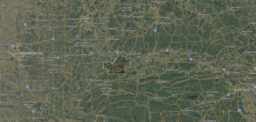
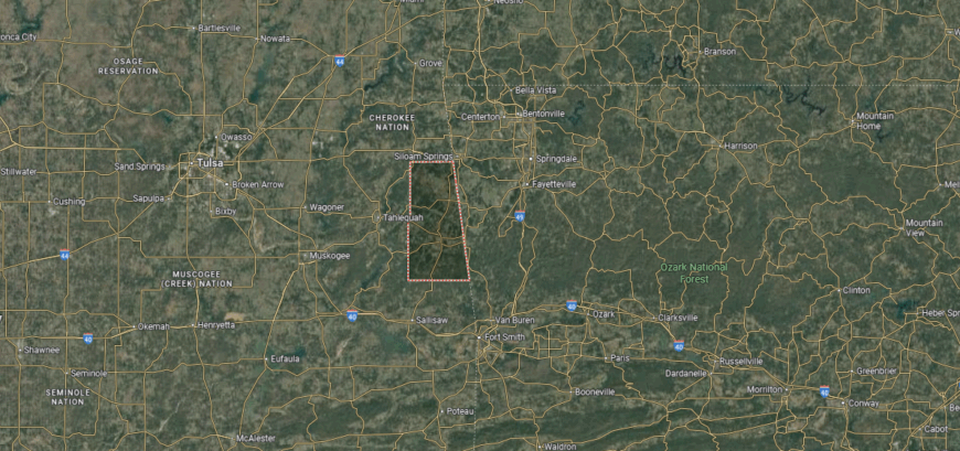
#19. Le Flore County (tie)
– Life expectancy: 72.1 years
— 2.3 years lower than the state average
You may also like: The top careers hiring for AI skills in Oklahoma, according to job postings
About
Le Flore County, Oklahoma stretches across the Ouachita Mountains and the Arkansas River Valley, giving it one of the most diverse landscapes in the state. Poteau, the county seat, sits near Cavanal Hill, often called “the world’s highest hill,” while nearby Wister Lake State Park and the Ouachita National Forest add to the county’s natural appeal. Its position along historic routes ties it to both frontier settlement and Native heritage, as much of the land was once part of the Choctaw Nation.
The economy is supported by agriculture, forestry, and energy, alongside tourism that thrives on the county’s mountains, rivers, and parks. Small industries and local businesses provide balance, while tribal enterprises add cultural and economic influence. Le Flore County stands out as a place where rugged landscapes, Native history, and modern livelihoods intersect.
Where is Le Flore County?
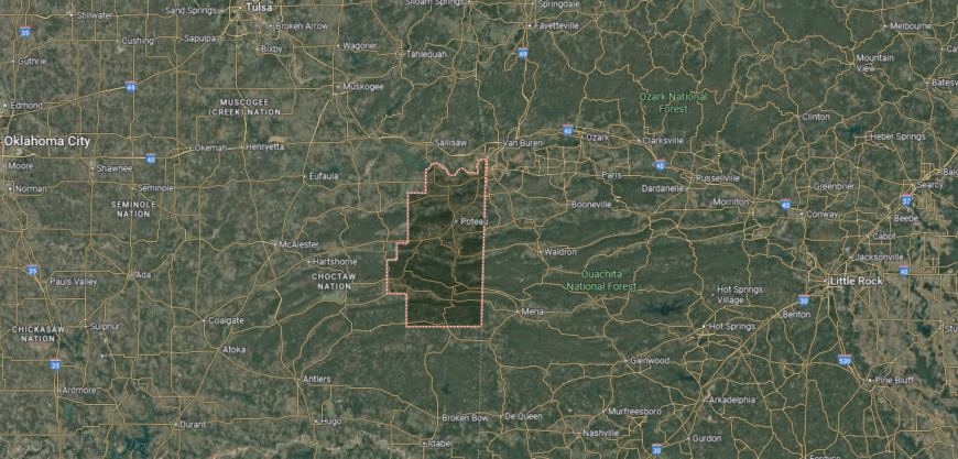
Le Flore County lies in far eastern Oklahoma, bordered by Arkansas to the east and Latimer County to the west. It is one of the state’s largest counties by area, stretching from the Arkansas River Valley into the Ouachita Mountains. The landscape ranges from fertile bottomlands to rugged forested peaks, including Cavanal Hill, often called the “world’s highest hill.”
Poteau serves as the county seat and is located near the base of Cavanal Hill. Heavener, Spiro, and Talihina are other important communities, each contributing to the county’s cultural and economic fabric. With highways, rail lines, and proximity to the Ouachita National Forest, Le Flore County ties together agriculture, industry, and outdoor recreation.
#18. Johnston County (tie)
– Life expectancy: 72.1 years
— 2.3 years lower than the state average
About
Johnston County, Oklahoma lies in the south-central part of the state, where rolling hills, streams, and farmland shape its character. Tishomingo, the county seat, is closely tied to the history of the Chickasaw Nation, serving as its historic capital and still carrying strong cultural influence today. Landmarks like the Chickasaw National Capitol Building highlight the county’s deep Native heritage.
Agriculture remains a cornerstone of the local economy, with cattle and crop production sustaining rural communities. Tourism adds vitality, as visitors come for outdoor recreation at Blue River, the Tishomingo National Wildlife Refuge, and cultural sites tied to Chickasaw history. Johnston County blends Native identity, natural beauty, and farming traditions into a distinct profile within Oklahoma.
Where is Johnston County?

Johnston County is located in south-central Oklahoma, bordered by Pontotoc County to the north and Marshall County to the south. It sits about 100 miles southeast of Oklahoma City and lies within a region of rolling prairies, wooded hills, and fertile river valleys. The Washita River flows through the county, shaping much of its landscape.
Tishomingo serves as the county seat and is known for its ties to the Chickasaw Nation, which has its historic capital there. Other communities such as Milburn, Ravia, and Mannsville contribute to the county’s rural network. With U.S. Highways 377 and 177 crossing the area, Johnston County links southern Oklahoma to both Lake Texoma and central parts of the state.
#17. Pittsburg County
– Life expectancy: 72.0 years
— 2.4 years lower than the state average
About
Pittsburg County, Oklahoma sits in the southeastern part of the state, where the Ouachita Mountains and open plains meet. McAlester, the county seat, developed as a major coal mining center in the late 19th century, leaving behind a legacy of industry and immigrant communities that shaped its culture. The county also plays a key role in state corrections, with the Oklahoma State Penitentiary adding both historic and economic significance.
While coal defined its past, today the economy relies on manufacturing, government services, healthcare, and retail. Agriculture, particularly cattle and poultry, continues across rural areas, while Lake Eufaula provides recreation and tourism opportunities. Pittsburg County reflects a blend of industrial heritage, cultural diversity, and modern adaptability, making it a vital part of southeastern Oklahoma.
Where is Pittsburg County?
Pittsburg County is situated in southeastern Oklahoma, bordered by Haskell County to the east and Atoka County to the south. It covers a diverse landscape of wooded hills, open plains, and lakes, with the Canadian River flowing across its northern portion. The county is also home to parts of the Ouachita Mountains, giving it a rugged and scenic terrain.
McAlester serves as the county seat and is the largest community, long known as a center for coal mining and regional commerce. Other towns such as Krebs, Hartshorne, and Haileyville add to the county’s character, each with roots in mining and agriculture. With U.S. Highways 69 and 270 running through, Pittsburg County is a transportation hub in southeastern Oklahoma.
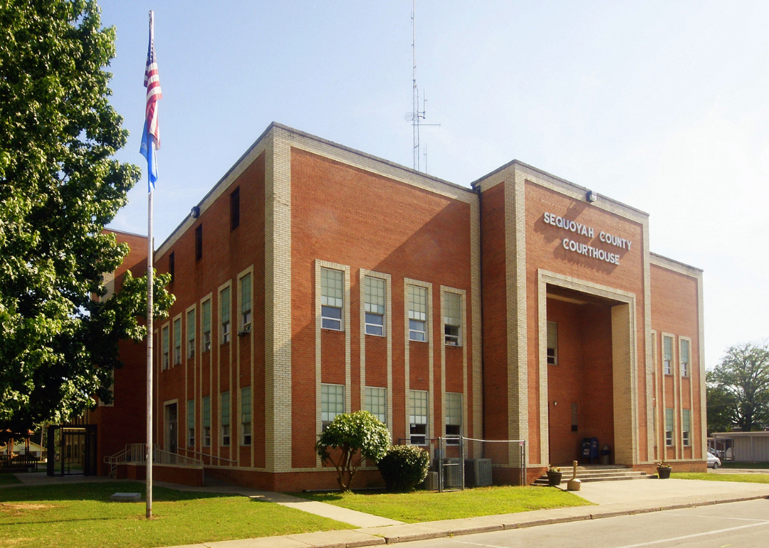
#16. Sequoyah County
– Life expectancy: 71.6 years
— 2.8 years lower than the state average
About
Sequoyah County, Oklahoma rests along the Arkansas River in the state’s eastern hills, carrying a name that honors Sequoyah, the Cherokee leader who created the Cherokee syllabary. Sallisaw, the county seat, serves as a central hub, while historic sites and landmarks preserve the area’s deep Cherokee heritage. The county’s landscape of rivers, valleys, and wooded hills ties its identity closely to both Native history and natural resources.
The economy blends agriculture, manufacturing, and trade, with cattle and crops anchoring rural areas. Tourism plays a strong role as well, with visitors drawn to Sequoyah’s Cabin, state parks, and the Arkansas River for recreation. Sequoyah County reflects a lasting balance of Native tradition, agricultural roots, and community resilience.
Where is Sequoyah County?
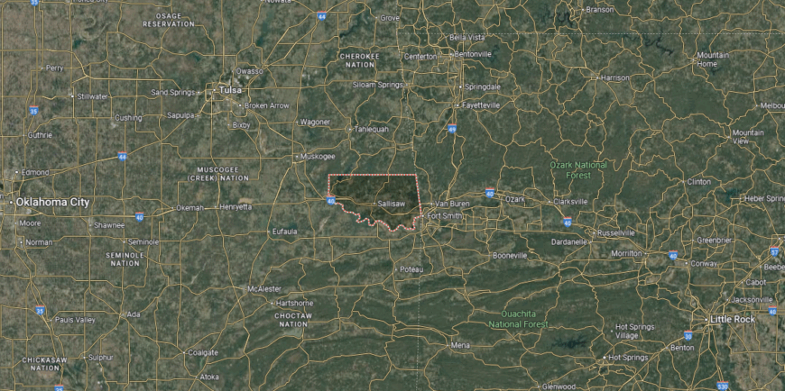
Sequoyah County lies in eastern Oklahoma, directly bordering Arkansas along the Arkansas River. The county’s landscape includes river valleys, wooded hills, and farmland, with the Arkansas River and Robert S. Kerr Reservoir shaping much of its eastern edge. It sits about 25 miles west of Fort Smith, Arkansas, and roughly 125 miles east of Tulsa.
Sallisaw serves as the county seat and is centrally located along Interstate 40. Other communities such as Muldrow, Roland, and Vian add to the county’s network of small towns. With its rivers, reservoirs, and major highways, Sequoyah County connects eastern Oklahoma to the Arkansas border region.
#15. Garvin County
– Life expectancy: 71.5 years
— 2.9 years lower than the state average

About
Garvin County, Oklahoma lies in the south-central part of the state, where fertile farmland and the Washita River Valley have long supported settlement and growth. Pauls Valley, the county seat, is known for its historic Main Street, courthouse square, and cultural landmarks that reflect both pioneer history and small-town traditions. The area’s location along major highways has also made it a crossroads of trade and travel.
Agriculture remains central to the county’s economy, with cattle, poultry, and crops forming its foundation. Energy production and manufacturing add strength, while local businesses and services support community life. Garvin County blends rural productivity, transportation ties, and historic character into a profile that continues to evolve.
Where is Garvin County?

Garvin County is located in south-central Oklahoma, bordered by McClain County to the north and Murray County to the south. The Washita River flows through the area, creating fertile valleys amid rolling prairies and wooded hills. It lies about 60 miles south of Oklahoma City, giving the county close ties to the state’s capital region.
Pauls Valley serves as the county seat and sits along Interstate 35, which connects the area to both Oklahoma City and Dallas. Lindsay, Wynnewood, and Stratford are other notable towns, each supporting the county’s agricultural and economic base. With its position on major highways, Garvin County serves as a link between central and southern Oklahoma.
#14. Blaine County
– Life expectancy: 71.0 years
— 3.4 years lower than the state average
You may also like: These are the most prevalent disabilities in Oklahoma
About
Blaine County, Oklahoma sits on the western plains, where red soil, wide horizons, and rugged landscapes define its setting. Watonga, the county seat, is known for its annual cheese festival and historic downtown, while Roman Nose State Park showcases natural springs, canyons, and outdoor recreation. The county’s mix of prairie and unique geological features highlights its distinctive character within Oklahoma.
Agriculture anchors the economy with wheat, cattle, and poultry production, while oil, gas, and wind energy provide additional layers of growth. Small industries and tourism tied to state parks and cultural events contribute to local vitality. Blaine County reflects a balance of natural landmarks, agricultural tradition, and energy development that shapes its identity.
Where is Blaine County?
Blaine County rests in central Oklahoma, bordered by Major County to the north and Canadian County to the south. Its landscape features wide prairies, fertile farmland, and parts of the gypsum hills that make the region distinctive. The county lies about 70 miles northwest of Oklahoma City, offering both rural space and proximity to the state’s urban core.
Watonga serves as the county seat and is known for its history, agriculture, and annual cheese festival. Smaller towns such as Okeene, Geary, and Canton contribute to the county’s rural framework. With U.S. Highways 270 and 281 running through, Blaine County connects western Oklahoma communities to larger state routes.
#13. Adair County
– Life expectancy: 70.9 years
— 3.5 years lower than the state average
About
Adair County, Oklahoma rests in the foothills of the Ozark Mountains, where forests, streams, and rolling hills define its landscape. Stilwell, the county seat, is widely known as the “Strawberry Capital of the World,” with its annual festival drawing visitors from across the region. Much of the county’s identity is tied to the Cherokee Nation, whose presence and heritage remain strong throughout the area.
Agriculture supports local life, with strawberries, cattle, and poultry forming important parts of the economy. Timber and small industries add stability, while tourism tied to Cherokee culture and outdoor recreation continues to grow. Adair County blends Native heritage, agricultural pride, and mountain scenery into a distinctive corner of Oklahoma.
Where is Adair County?
Adair County is positioned in far northeastern Oklahoma, sharing its eastern border with Arkansas. The Ozark Plateau shapes much of its geography, with wooded hills, fertile valleys, and clear streams defining the landscape. It sits about 80 miles southeast of Tulsa and roughly 40 miles west of Fayetteville, Arkansas.
Stilwell serves as the county seat and is centrally located within the county. Other communities include Westville, Watts, and Proctor, each contributing to the county’s rural network. With state highways crossing the region, Adair County links eastern Oklahoma to northwest Arkansas while retaining its small-town character.
#12. Okmulgee County (tie)
– Life expectancy: 70.8 years
— 3.6 years lower than the state average
About
Okmulgee County, Oklahoma is steeped in Native history, serving as the historic capital of the Muscogee (Creek) Nation. The city of Okmulgee, the county seat, preserves this legacy through landmarks such as the Creek Council House and cultural institutions that celebrate tribal heritage. Beyond its historic core, lakes, wildlife areas, and rolling prairies shape the county’s landscape.
Agriculture, particularly cattle and crops, provides a strong base for the economy, while energy and manufacturing add diversity. Tribal enterprises and cultural tourism also contribute, linking history with modern opportunity. Okmulgee County stands out as a place where Native governance, natural resources, and rural traditions intersect to define its character.
Where is Okmulgee County?
Okmulgee County is located in eastern Oklahoma, bordered by Tulsa County to the north and McIntosh County to the south. The Deep Fork River runs across the county, shaping fertile valleys amid rolling hills and woodlands. Positioned about 35 miles south of Tulsa, the county blends rural landscapes with access to a major metropolitan area.
Okmulgee, the county seat, is also the headquarters of the Muscogee (Creek) Nation, giving the community strong cultural and historical significance. Henryetta, Beggs, and Morris are other key towns that support the county’s economy and identity. With U.S. Highways 75 and 62 running through, Okmulgee County remains closely tied to both local heritage and statewide connections.
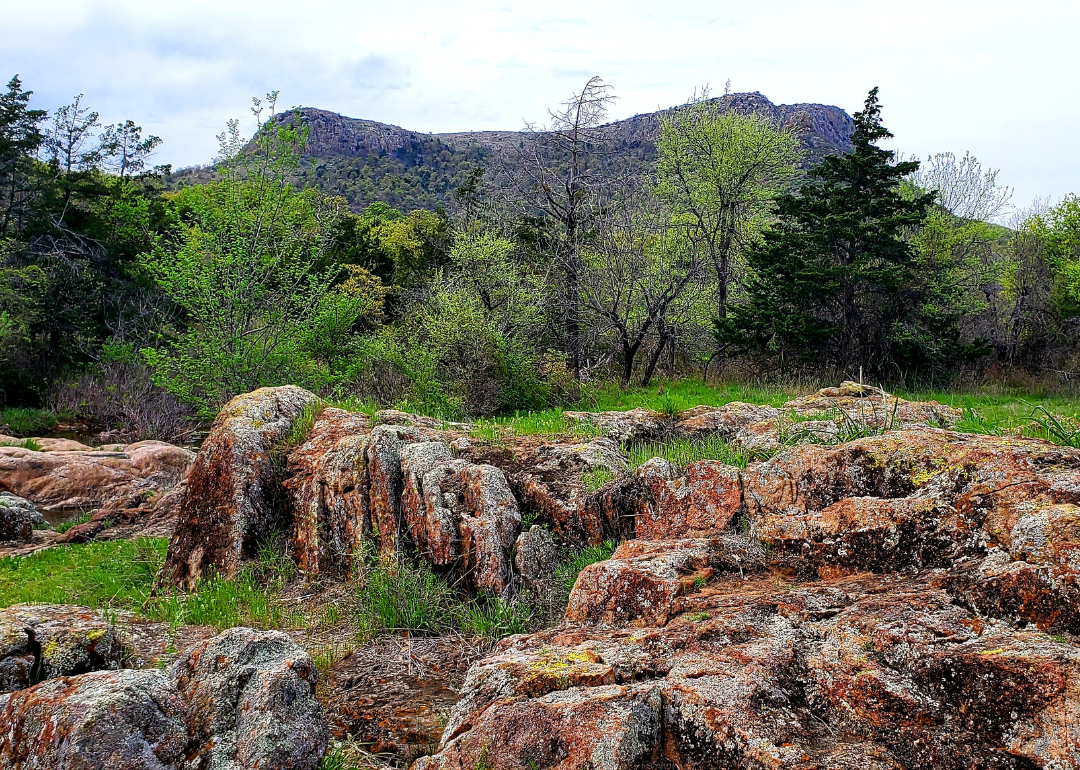
#11. Kiowa County (tie)
– Life expectancy: 70.8 years
— 3.6 years lower than the state average

About
Kiowa County, Oklahoma grew rapidly after the 1901 land lottery opened the area to settlement, with Hobart emerging as a centerpiece of trade and civic life. The county’s name honors the Kiowa people, whose history and presence remain part of the region’s identity. Historic buildings, museums, and landmarks preserve stories of both Native heritage and pioneer life.
While farming and ranching continue to anchor the local economy, the county also benefits from its proximity to the Wichita Mountains. Quartz Mountain draws visitors for hiking, camping, and the arts, adding tourism as a steady contributor. Kiowa County reflects a place where history, land, and culture intersect in meaningful ways.
Where is Kiowa County?
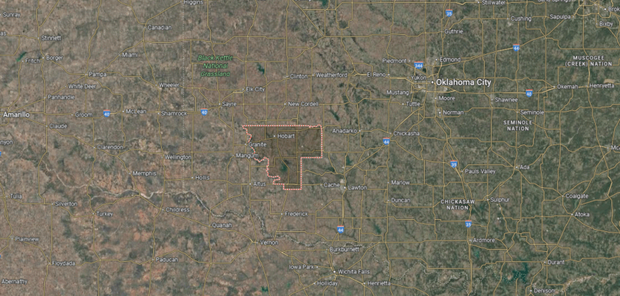
Kiowa County is found in southwestern Oklahoma, bordered by Washita County to the north and Tillman County to the south. The county lies within the foothills of the Wichita Mountains, giving it a mix of rugged granite peaks, rolling prairies, and fertile farmland. It is positioned about 120 miles southwest of Oklahoma City and 80 miles north of Wichita Falls, Texas.
Hobart serves as the county seat and is located near the center of the county. Other communities such as Snyder, Mountain Park, and Gotebo reflect the area’s rural and agricultural roots. With U.S. Highways 183 and 62 running through, Kiowa County connects the Wichita Mountain region to the rest of southwestern Oklahoma.
#10. Muskogee County (tie)
– Life expectancy: 70.8 years
— 3.6 years lower than the state average

About
Muskogee County, Oklahoma holds a central place in the state’s story, with Muskogee—its county seat—immortalized in song and known for its cultural and historic influence. The city grew as a river port along the Arkansas River and later as a hub for railroads, leaving behind a legacy of trade, transportation, and civic pride. Landmarks like the Five Civilized Tribes Museum and Honor Heights Park highlight both Native and regional heritage.
The economy today blends agriculture, manufacturing, healthcare, and energy, while education and retail strengthen its role as a regional center. Tourism tied to festivals, music, and cultural institutions adds another layer of vitality. Muskogee County reflects a mix of historic significance, Native heritage, and modern adaptability, making it one of Oklahoma’s defining counties.
Where is Muskogee County?
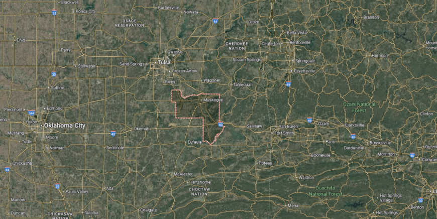
Muskogee County is situated in eastern Oklahoma, where the Arkansas, Verdigris, and Grand Rivers come together. The county’s landscape includes fertile river bottoms, rolling hills, and sections of the Cookson Hills to the east. It lies about 50 miles southeast of Tulsa and serves as a crossroads between northeastern and southeastern Oklahoma.
Muskogee, the county seat and largest city, is positioned along the Arkansas River and has long been a hub for trade, culture, and transportation. Smaller towns such as Fort Gibson, Boynton, and Warner add to the county’s network of communities. With Interstates 40 and 69 intersecting nearby, Muskogee County holds a central place in the state’s river and highway systems.
#9. Hughes County (tie)
– Life expectancy: 70.8 years
— 3.6 years lower than the state average
You may also like: Fastest-growing jobs in Oklahoma
About
Hughes County, Oklahoma lies in the east-central part of the state, where prairies and wooded hills shape a largely rural landscape. Holdenville, the county seat, carries historic ties to the railroad era and remains a small-town center of commerce and culture. The county’s history is also deeply tied to the Muscogee (Creek) Nation, whose influence continues to be seen in local traditions and communities.
Agriculture anchors much of the economy, with cattle, poultry, and crops providing stability for rural residents. Energy production, particularly oil and natural gas, adds another layer of economic activity, while small businesses and local services sustain community life. Hughes County blends Native heritage, agricultural strength, and resource-based development into a resilient profile.
Where is Hughes County?
Hughes County lies in east-central Oklahoma, bordered by Okfuskee County to the north and Pontotoc County to the south. Its terrain is a mix of rolling prairies, wooded hills, and farmland, with the Canadian River forming part of its northern boundary. The county is positioned about 80 miles southeast of Oklahoma City and 70 miles southwest of Tulsa.
Holdenville serves as the county seat and is located near the center of the county. Other towns such as Wetumka, Dustin, and Atwood reflect the county’s agricultural and small-town traditions. With state highways connecting it in all directions, Hughes County serves as a rural crossroads in east-central Oklahoma.
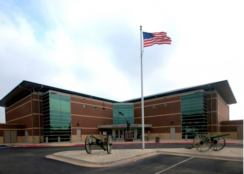
#8. Ottawa County
– Life expectancy: 70.6 years
— 3.8 years lower than the state average
About
Ottawa County, Oklahoma sits in the far northeast corner of the state, where rolling hills and waterways link it closely to the Ozarks. Miami, the county seat, is known for its historic Coleman Theatre and its ties to Route 66, which continues to draw visitors through the region. The county’s cultural fabric is shaped by several tribal nations, including the Miami, Peoria, and Shawnee, whose heritage remains central to local identity.
Mining once dominated Ottawa County’s economy, with lead and zinc production fueling growth during the 20th century. While that industry has declined, agriculture, manufacturing, and tourism now provide balance, with Route 66 landmarks and tribal enterprises adding vitality. Ottawa County reflects a blend of Native history, industrial legacy, and cultural tourism that makes it a distinctive part of Oklahoma.
Where is Ottawa County?
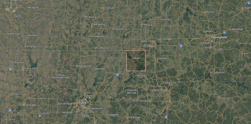
Ottawa County sits in the far northeastern corner of Oklahoma, where the state meets both Kansas and Missouri. The county’s geography is defined by the Ozark Plateau, with rolling hills, hardwood forests, and the Neosho and Spring rivers flowing through its valleys. It is also part of the Tri-State Mining District, once a major center for lead and zinc production.
Miami serves as the county seat and largest community, positioned along U.S. Route 69. Other towns such as Commerce, Quapaw, and Fairland contribute to the county’s history and rural character. With its location at a three-state junction, Ottawa County links Oklahoma to Missouri and Kansas through both highways and regional trade.
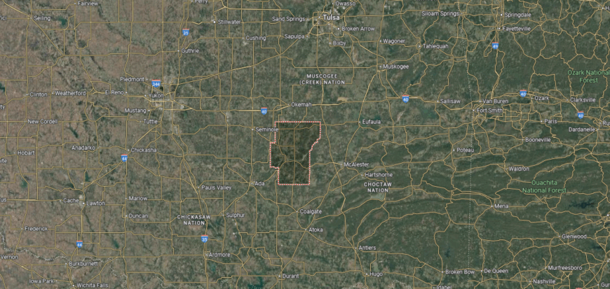
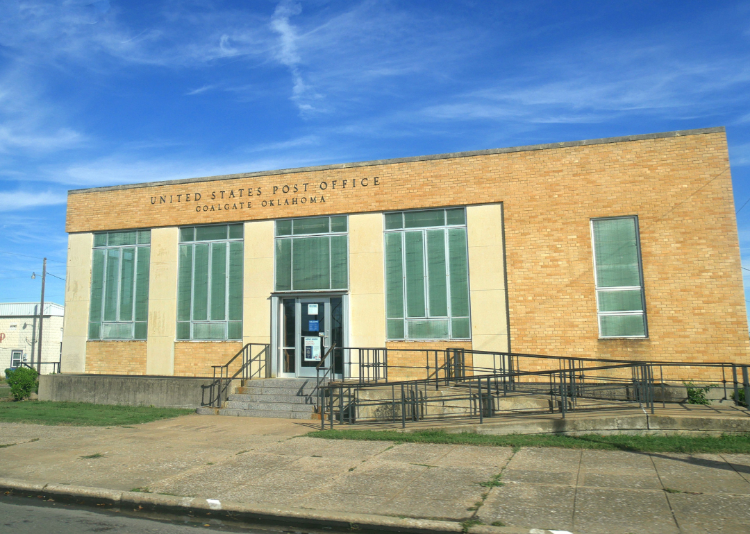
#7. Coal County
– Life expectancy: 70.4 years
— 4.0 years lower than the state average
About
Coal County, Oklahoma takes its name from the coal deposits that fueled its early growth and shaped the communities that emerged around mining. Coalgate, the county seat, reflects this heritage with historic buildings and ties to the railroads that once carried coal across the region. The county’s landscape of prairies, wooded hills, and streams ties its history to both land and resource.
While coal is no longer the dominant force, agriculture provides the backbone of the modern economy, with cattle and crops sustaining rural life. Small industries, energy production, and local services add stability, keeping the county connected to broader markets. Coal County blends resource-driven history with enduring rural traditions, creating a profile rooted in both resilience and heritage.
Where is Coal County?
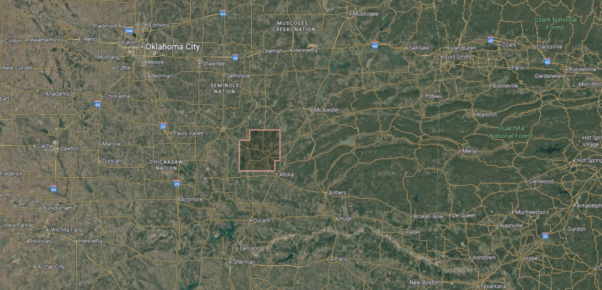
Coal County is located in south-central Oklahoma, bordered by Hughes County to the north and Atoka County to the south. True to its name, the county was historically shaped by coal mining, with rolling hills, wooded areas, and fertile valleys forming its landscape. It sits about 100 miles southeast of Oklahoma City and 120 miles north of the Texas border.
Coalgate serves as the county seat and is positioned near the center of the county. Other communities such as Lehigh, Centrahoma, and Tupelo reflect the area’s rural and mining heritage. With state highways providing connections, Coal County links small-town Oklahoma to broader regional routes.
#6. Caddo County (tie)
– Life expectancy: 70.0 years
— 4.4 years lower than the state average
About
Caddo County, Oklahoma rests in the state’s southwest, where fertile farmland and rolling plains have long supported settlement and growth. Anadarko, the county seat, is often called the “Indian Capital of the Nation,” reflecting the presence of multiple tribal nations and cultural institutions such as the Southern Plains Indian Museum. This strong Native influence gives the county a distinctive identity within Oklahoma.
Agriculture remains a foundation of the economy, with wheat, cotton, and cattle production shaping rural life. Energy development, particularly oil, gas, and wind, provides additional strength, while cultural tourism tied to tribal heritage contributes as well. Caddo County stands out as a place where Native traditions, agricultural productivity, and resource development all intersect.
Where is Caddo County?
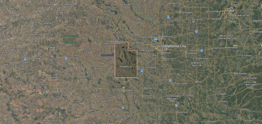
Caddo County is located in central Oklahoma, bordered by Blaine County to the north and Grady County to the south. Its landscape includes fertile farmland, stretches of prairie, and the rugged Wichita Mountains along its southwestern edge. The county sits about 50 miles west of Oklahoma City, placing it within easy reach of the state’s capital.
Anadarko serves as the county seat and is home to a strong Native American presence, with several tribal agencies and cultural centers based there. Other towns such as Carnegie, Binger, and Cement highlight the county’s agricultural and small-town roots. With U.S. Highways 62 and 281 crossing the area, Caddo County ties western Oklahoma to the central part of the state.
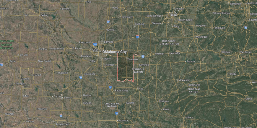
#5. Seminole County (tie)
– Life expectancy: 70.0 years
— 4.4 years lower than the state average
About
Seminole County, Oklahoma carries a strong Native legacy, with its name honoring the Seminole Nation, whose presence continues to shape the area’s culture and identity. Wewoka, the county seat, is home to the Seminole Nation Museum and the annual Sorghum Festival, both of which highlight the county’s traditions and history. The landscape of prairies, woodlands, and creeks provides a backdrop closely tied to farming and community life.
Oil brought dramatic change in the early 20th century, making Seminole County one of the centers of Oklahoma’s oil boom. While energy production still plays a role, agriculture, small businesses, and tribal enterprises now support the local economy. Seminole County reflects a mix of Native heritage, oil history, and rural strength that continues to define its character.
Where is Seminole County?
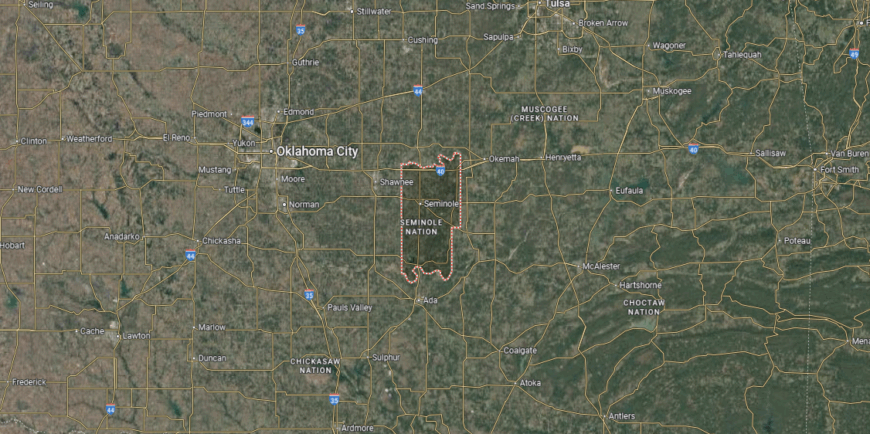
Seminole County sits in east-central Oklahoma, bordered by Pottawatomie County to the west and Hughes County to the east. The Canadian River marks part of its northern boundary, and the county’s terrain mixes fertile farmland with rolling prairies and wooded areas. It lies about 55 miles southeast of Oklahoma City, giving it close ties to the state’s central region.
Wewoka serves as the county seat and is also the capital of the Seminole Nation, reflecting the area’s deep tribal heritage. Seminole and Konawa are other key towns, each shaped by oil booms and agriculture. With state highways and proximity to Interstate 40, Seminole County maintains strong links to both central and eastern Oklahoma.
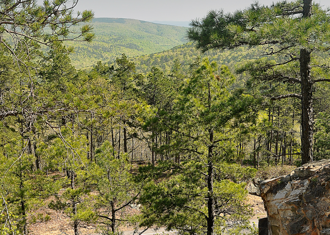
#4. Pushmataha County (tie)
– Life expectancy: 69.9 years
— 4.5 years lower than the state average
You may also like: How gas prices have changed in Oklahoma in the last week
About
Pushmataha County, Oklahoma is set in the rugged Kiamichi Mountains of the southeast, where forests, rivers, and valleys dominate the landscape. Antlers, the county seat, is known as the “Deer Capital of the World,” reflecting both its natural surroundings and the county’s connection to outdoor life. The area carries deep ties to the Choctaw Nation, whose history and culture remain visible across the county.
Timber and agriculture form the backbone of the economy, with cattle, poultry, and forestry sustaining local livelihoods. Outdoor recreation—from hunting and fishing to hiking in the Ouachita National Forest—also contributes through tourism. Pushmataha County blends mountain scenery, Native heritage, and rural traditions into one of the most distinctive profiles in Oklahoma.
Where is Pushmataha County?
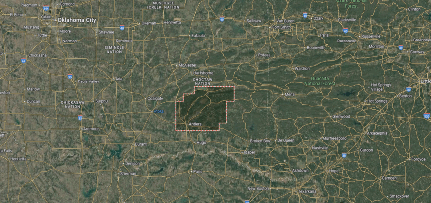
Pushmataha County lies in southeastern Oklahoma, bordered by Le Flore County to the east and Atoka County to the west. It is one of the state’s most rugged counties, dominated by the Kiamichi Mountains, forested ridges, and valleys carved by the Kiamichi River. The area sits about 150 miles southeast of Oklahoma City and just north of the Texas border.
Antlers serves as the county seat, located along the Kiamichi River valley. Clayton, Albion, and Rattan are smaller towns that add to the county’s rural network. With U.S. Highway 271 and access to large portions of the Ouachita National Forest, Pushmataha County is both a transportation link and a destination for outdoor recreation.
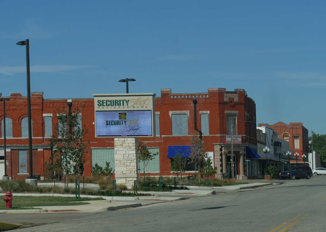
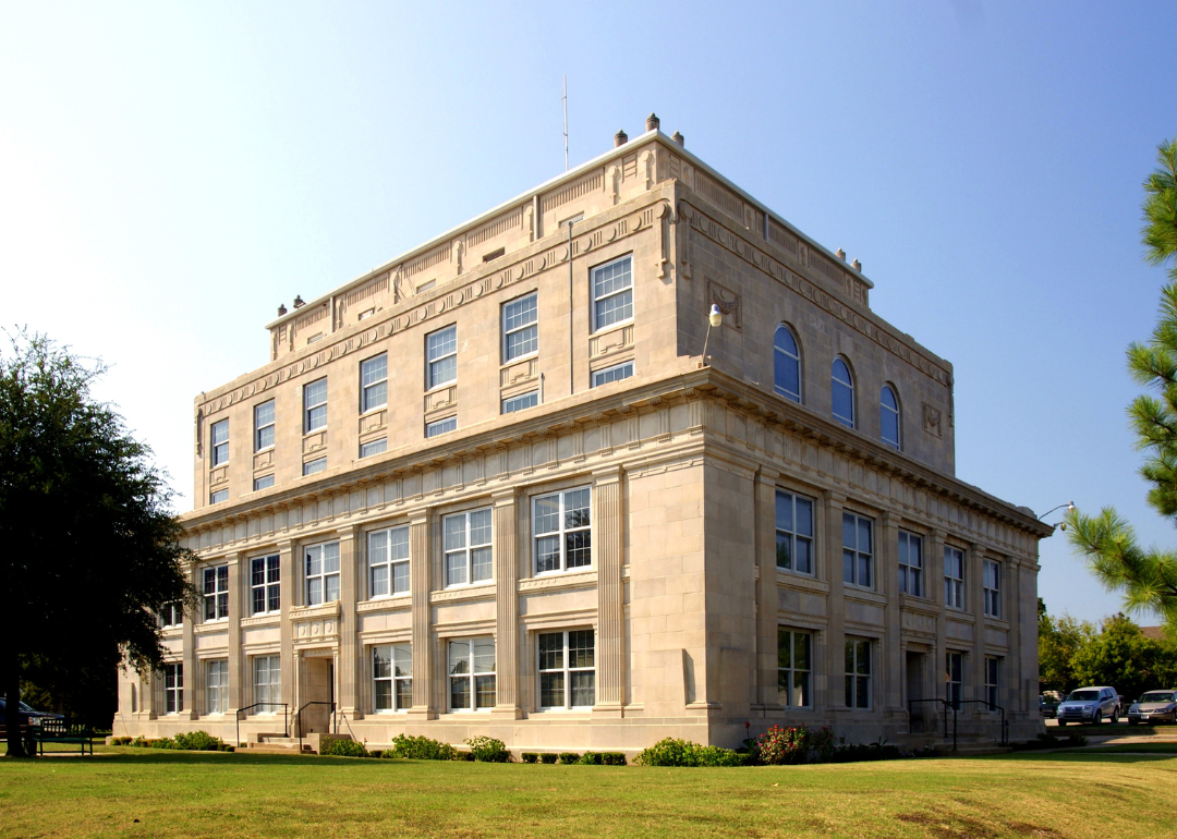
#3. Choctaw County (tie)
– Life expectancy: 69.9 years
— 4.5 years lower than the state average
About
Choctaw County, Oklahoma lies in the southeastern part of the state, where the Red River forms its southern boundary and rolling hills meet fertile bottomlands. Hugo, the county seat, is known as the “Circus City, USA,” home to winter quarters for several circuses and the famous Showmen’s Rest cemetery that honors performers. The county also carries deep ties to the Choctaw Nation, whose heritage continues to shape local culture.
Agriculture plays a steady role in the economy, with cattle, poultry, and crops anchoring rural life. Tourism adds vitality through lakes, historic sites, and cultural events that draw visitors to the region. Choctaw County reflects a mix of Native history, unique traditions, and rural strength that give it a distinct identity within Oklahoma.
Where is Choctaw County?
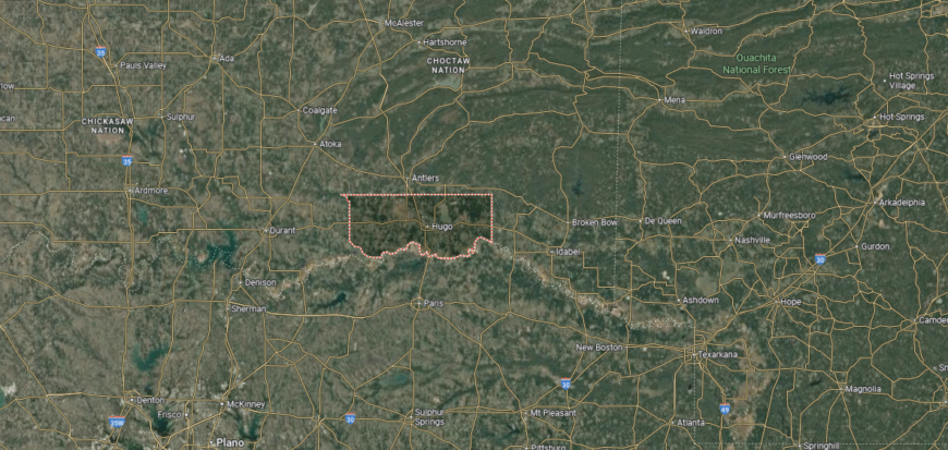
Choctaw County is located in southeastern Oklahoma, sharing its southern boundary with Texas along the Red River. The terrain is marked by fertile river valleys, rolling prairies, and wooded hills, with Hugo Lake and the Kiamichi River adding to its natural features. It lies about 130 miles southeast of Oklahoma City and 120 miles northeast of Dallas.
Hugo serves as the county seat and is known for its connections to the railroad and its unique history as a winter home for traveling circuses. Other towns such as Boswell, Soper, and Fort Towson reflect the county’s rural and agricultural character. With U.S. Highway 70 running east–west, Choctaw County provides a key link between Oklahoma and northern Texas.
#2. Okfuskee County
– Life expectancy: 69.2 years
— 5.2 years lower than the state average
About
Okfuskee County, Oklahoma sits in the east-central part of the state, where prairies and wooded hills shape a mostly rural setting. Okemah, the county seat, is celebrated as the hometown of folk singer Woody Guthrie, and his legacy continues to influence the county’s cultural identity through festivals and music events. The county also carries strong ties to the Muscogee (Creek) Nation, whose heritage remains a central part of local life.
Agriculture provides the backbone of the economy, with cattle, hay, and crops supporting rural communities. Small businesses, energy production, and tourism tied to Guthrie’s legacy add further stability. Okfuskee County blends musical heritage, Native history, and agricultural tradition into a profile that is both distinctive and enduring.
Where is Okfuskee County?
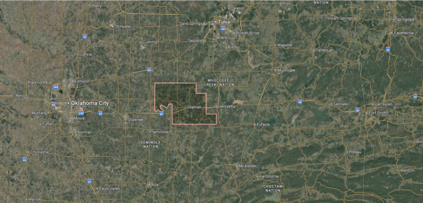
Okfuskee County is set in east-central Oklahoma, bordered by Creek County to the north and Hughes County to the south. Its landscape is a mix of rolling prairies, farmland, and wooded areas, with the North Canadian River flowing through its northern portion. The county is positioned about 60 miles east of Oklahoma City and 75 miles south of Tulsa.
Okemah serves as the county seat and is well known as the birthplace of folk musician Woody Guthrie. Smaller communities such as Paden, Boley, and Weleetka add to the county’s rural network and history, with Boley standing out as one of the historic all-Black towns in Oklahoma. State highways crossing the area connect Okfuskee County to both central and eastern parts of the state.
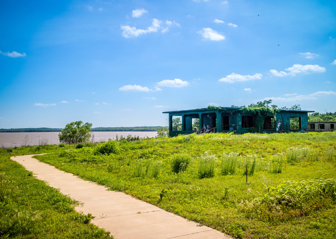
#1. McCurtain County
– Life expectancy: 69.1 years
— 5.3 years lower than the state average

About
McCurtain County, Oklahoma lies in the state’s far southeast corner, where dense pine forests and the Ouachita Mountains create some of the most striking scenery in Oklahoma. Idabel, the county seat, anchors local life, while Broken Bow has become a major destination thanks to Beavers Bend State Park and the nearby Mountain Fork River. The county’s natural beauty and outdoor attractions make it a cornerstone of Oklahoma tourism.
The economy is driven by forestry, tourism, and agriculture, with timber production long serving as a foundation. In recent decades, cabins, resorts, and recreation around Broken Bow Lake have fueled rapid growth in hospitality and services. McCurtain County stands out as a place where natural landscapes, economic vitality, and cultural traditions converge at the edge of the Ouachitas.
Where is McCurtain County?
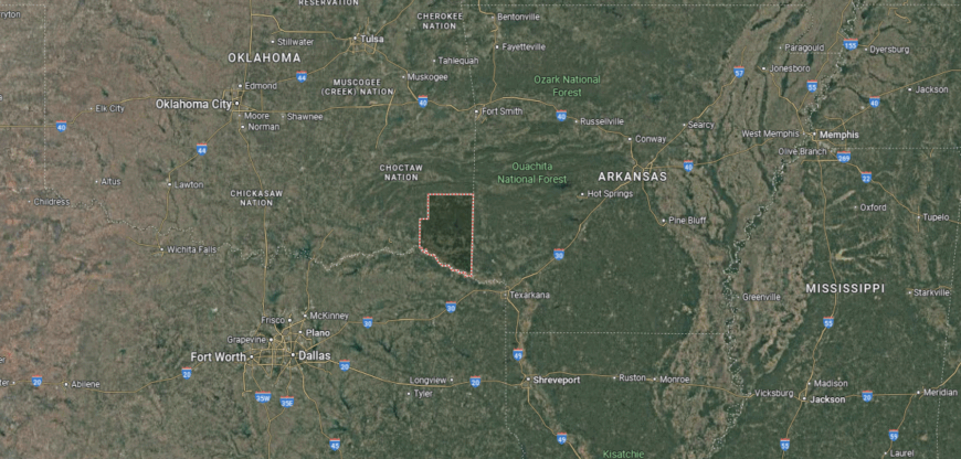
McCurtain County is located in the far southeastern corner of Oklahoma, bordered by Arkansas to the east and Texas to the south along the Red River. It is the state’s most heavily forested county, dominated by the Ouachita Mountains, pine woodlands, and river valleys. The area sits roughly 200 miles southeast of Oklahoma City and is known for its rugged terrain and natural beauty.
Idabel serves as the county seat and is positioned near the center of the county. Broken Bow, located to the north, is a gateway to Beavers Bend State Park and the Mountain Fork River, making it a hub for tourism and recreation. Other towns such as Valliant, Haworth, and Wright City reflect the county’s strong ties to forestry and rural life.
This story features data reporting by Karim Noorani, writing by Kiersten Hickman, and is part of a series utilizing data automation across 49 states.
By Stacker