Best counties to live in Pennsylvania
More counties in the United States experienced population growth in the last year, according to the latest Census data, even as pandemic-related moving trends begin to normalize.
Counties in the South continued to experience growth, particularly in Florida, where 96% of its 67 counties gained new residents. Polk County, Florida, a suburb of Orlando, added the most, with 26,000 people moving there in 2023.
Meanwhile, counties in the Midwest and Northeast continued to lose population, but at slower rates than the year before. Some of the biggest losses were in counties home to large cities, including Cook County, Illinois (home of Chicago) and the boroughs of Brooklyn and Queens in New York.
Many counties are experiencing growth due to their job opportunities, education, or relatively affordable housing costs. Others are favored for their historic or well-designed downtowns or access to cultural opportunities.
Stacker compiled a list of the best counties to live in Pennsylvania using rankings from Niche. Niche ranks counties by various factors including public schools, educational attainment, cost of living, and housing.
Keep reading to see if your county made the list.
You may also like: These 10 car insurers have the highest market share in Pennsylvania
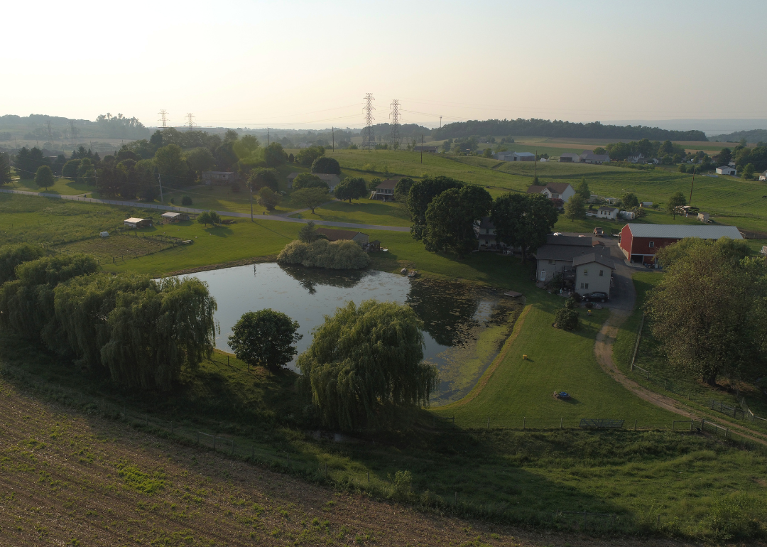
#30. Franklin County, Pennsylvania
– Overall Rank: Not ranked
– Population: 156,084
– Median household income: $71,808
– Median home value: $222,000 (73% own)
– Median rent: $1,019 (27% rent)
– Top public schools: Greencastle-Antrim Senior High School (grade A minus), Greencastle-Antrim Middle School (grade B+), Greencastle-Antrim Elementary School (grade B+)
– Top private schools: Mercersburg Academy (grade A+), Cumberland Valley Christian School (grade B), Shalom Christian Academy (grade C+)
– Top places: Greencastle (grade A minus), Shippensburg (grade B+), Southampton Township (grade B)
In order to come up with the very specific design ideas, we create most designs with the assistance of state-of-the-art AI interior design software.
About
Franklin County’s economy is anchored by manufacturing, healthcare, and logistics, strengthened by its location along the I-81 corridor. Agriculture remains vital, with dairy, produce, and livestock shaping the landscape across rural townships. Chambersburg, the county seat, supports this base with hospitals, schools, and government services, while Waynesboro, Greencastle, and Mercersburg contribute their own industries and traditions.
The county’s setting in the Cumberland Valley offers farmland, parks, and access to the Appalachian Trail. Residents enjoy festivals, historic sites tied to the Civil War, and a strong network of community organizations. With its blend of industry, farming, and heritage, Franklin County stands as a dynamic hub in south-central Pennsylvania.
Where is Franklin County?
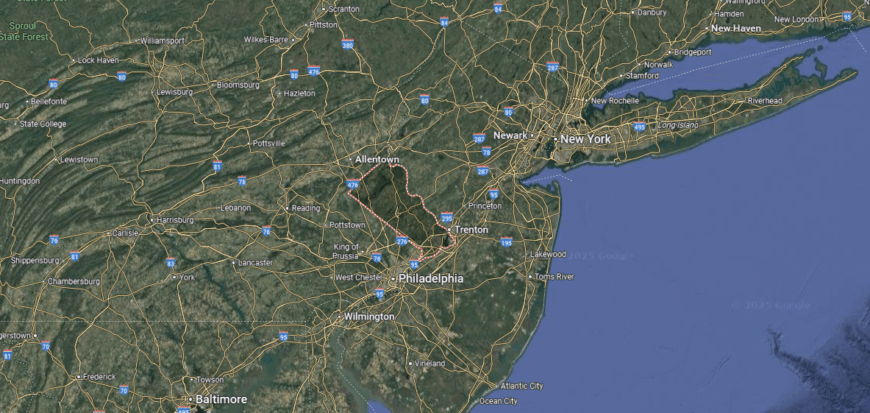
Franklin County is positioned in south-central Pennsylvania, bordering Maryland to the south. It lies about 55 miles southwest of Harrisburg and 90 miles northwest of Washington, D.C., making it part of the Cumberland Valley region.
Interstate 81 runs north–south through the county, connecting it directly to cities across the East Coast, while U.S. Route 30 provides an east–west corridor through Chambersburg, the county seat. Its location places it at the crossroads of Pennsylvania’s agricultural heartland and the Mid-Atlantic’s major urban centers.
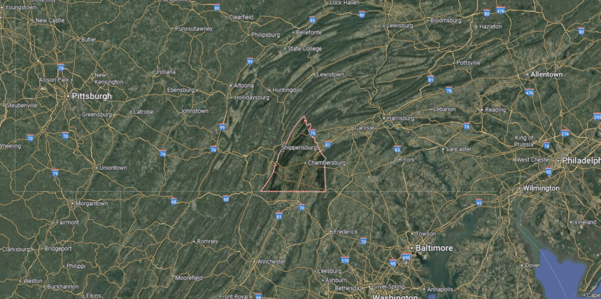
#29. Lebanon County, Pennsylvania
– Overall Rank: Not ranked
– Population: 143,258
– Median household income: $72,532
– Median home value: $211,400 (72% own)
– Median rent: $1,023 (28% rent)
– Top public schools: Lingle Avenue Elementary School (grade A), Pine Street Elementary School (grade A), Palmyra Area Middle School (grade A minus)
– Top private schools: Lebanon Christian Academy (grade B+), New Covenant Christian School (grade B minus), Myerstown Mennonite School (grade unavailable)
– Top places: North Londonderry Township (grade A minus), Cleona (grade A minus), Palmyra (grade B+)
About
Lebanon County reflects its Pennsylvania Dutch heritage through traditions, festivals, and foods like Lebanon bologna. The economy is built on agriculture, manufacturing, and healthcare, with small businesses tying together both rural and urban areas. Lebanon serves as the county seat, while Palmyra, Myerstown, and Annville add their own historic character.
Residents enjoy Middle Creek Wildlife Management Area, local fairs, and landmarks that highlight the county’s history. Colleges, theaters, and community venues bring cultural life to the region. With its balance of tradition, industry, and lifestyle, Lebanon County blends heritage with modern opportunity.
Where is Lebanon County?
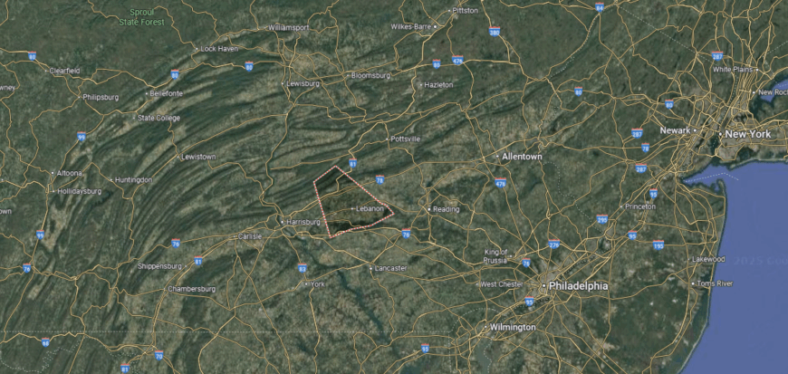
Lebanon County sits in south-central Pennsylvania, about 25 miles east of Harrisburg and 30 miles west of Reading. It lies within the Lebanon Valley, a fertile stretch of land framed by the Blue Mountain ridge to the north and the South Mountain range to the south.
Interstate 81 passes just north of the county, while the Pennsylvania Turnpike (Interstate 76) runs along its southern edge, with U.S. Route 422 cutting directly through the city of Lebanon. Its location gives it both rural character and strong connections to the state’s major east–west travel routes.
#28. Luzerne County, Pennsylvania
– Overall Rank: Not ranked
– Population: 325,396
– Median household income: $60,836
– Median home value: $152,400 (67% own)
– Median rent: $904 (33% rent)
– Top public schools: Wycallis Elementary School (grade A minus), Dallas Elementary School (grade B+), Salem Elementary School (grade B+)
– Top private schools: Wyoming Seminary College Preparatory School (grade A+), MMI Preparatory School (grade A), Holy Redeemer High School (grade B)
– Top places: Dallas (grade A), Conyngham (grade A minus), Swoyersville (grade A minus)
About
Luzerne County is anchored by Wilkes-Barre, a city along the Susquehanna River with roots in coal mining and industry. The modern economy draws on healthcare, education, retail, and a growing logistics sector, while manufacturing still plays a role. Communities such as Hazleton, Pittston, and Nanticoke add their own schools, businesses, and cultural life.
Wilkes-Barre provides hospitals, colleges, and civic institutions that serve the wider region. Residents enjoy access to Mohegan Sun Arena, local theaters, and outdoor recreation in nearby state parks and the Pocono Mountains. With its mix of history, services, and natural access, Luzerne County balances tradition with opportunity.
Where is Luzerne County?
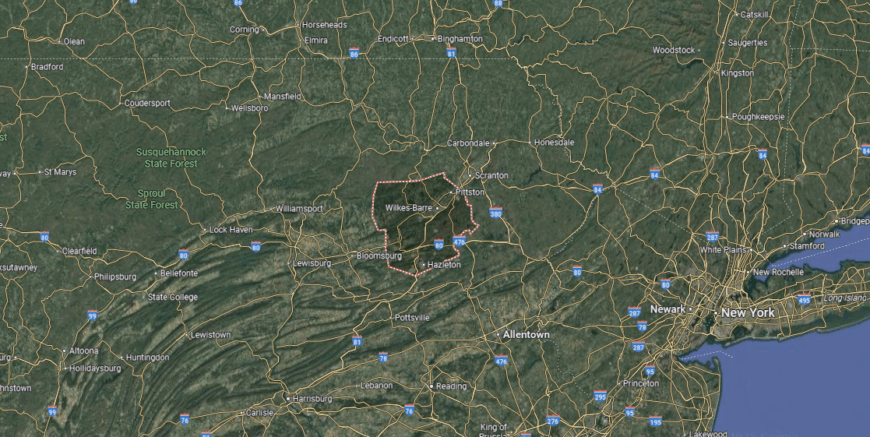
Luzerne County is located in northeastern Pennsylvania, about 20 miles southwest of Scranton and 100 miles northwest of Philadelphia. Centered around the Wyoming Valley and the city of Wilkes-Barre, it sits along the Susquehanna River where mountains and valleys converge.
Interstate 81 runs north–south through the county, while Interstates 80 and 476 provide key east–west and regional connections. Its position in the Pocono Plateau and Wyoming Valley makes it both a transportation hub and a gateway between Pennsylvania’s coal country and its larger metropolitan areas.
#27. Lycoming County, Pennsylvania
– Overall Rank: 1,342
– Population: 114,022
– Median household income: $63,437
– Median home value: $182,500 (70% own)
– Median rent: $886 (30% rent)
– Top public schools: Loyalsock Township Middle School (grade B+), C.E. McCall Middle School (grade B+), Hepburn-Lycoming Elementary School (grade B+)
– Top private schools: St. John Neumann Regional Academy (grade A minus), St. John Neumann Elementary School (grade unavailable), West Branch School (grade unavailable)
– Top places: Faxon (grade A), Muncy (grade A minus), Hughesville (grade B+)
About
Lycoming County stretches across the Appalachian foothills and valleys, with the West Branch Susquehanna River shaping much of its landscape. The economy is supported by healthcare, education, and manufacturing, alongside natural gas development and a long tradition of forestry. Williamsport, the county seat, anchors the region with schools, hospitals, and government services.
Residents enjoy outdoor life through Pine Creek Gorge, hiking trails, and state forests that define the county’s character. Cultural highlights include the Little League World Series, which brings international attention each summer. With its mix of natural beauty, strong industries, and community traditions, Lycoming County combines recreation with resilience.
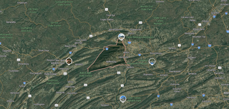
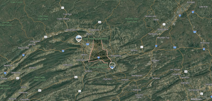
Where is Lycoming County?

Lycoming County sits in north-central Pennsylvania, with Williamsport as its county seat. It lies about 85 miles north of Harrisburg and 65 miles west of Scranton, occupying a vast stretch of the Appalachian Plateau that makes it the largest county by land area in the state.
U.S. Route 15 provides the main north–south corridor, while Interstate 180 and U.S. Route 220 connect Williamsport to surrounding regions. Its location places it deep in Pennsylvania’s interior, defined by forested ridges, river valleys, and a landscape that feels far removed from the state’s urban centers.
#26. Pike County, Pennsylvania
– Overall Rank: 1,257
– Population: 58,996
– Median household income: $76,416
– Median home value: $225,100 (84% own)
– Median rent: $1,344 (16% rent)
– Top public schools: Shohola Elementary School (grade A minus), Delaware Valley Middle School (grade A minus), Delaware Valley High School (grade B+)
– Top private schools: New Life Christian Day School (grade unavailable)
– Top places: Matamoras (grade B+), Milford Township (grade B+), Milford (grade B)
You may also like: States sending the most people to Pennsylvania
About
Pike County traces its history to the early 1800s, when the Delaware River and canals carried timber and trade through the region. Today, the economy leans on tourism, small businesses, and services, with residents benefiting from a growing connection to the New York and New Jersey metro areas. Milford, the county seat, provides schools, healthcare, and cultural life while towns like Dingmans Ferry and Matamoras add their own traditions.
The county is known for Delaware Water Gap National Recreation Area and natural landmarks that attract visitors year-round. Residents enjoy hiking, boating, and historic sites that connect present-day life with the past. With its blend of history, tourism, and scenic setting, Pike County continues to balance heritage with opportunity.
Where is Pike County?
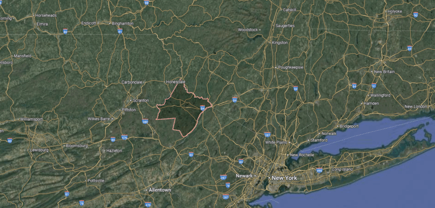
Pike County is found in Pennsylvania’s far northeastern corner, where the state meets New York and New Jersey. It lies about 75 miles northwest of New York City and 40 miles east of Scranton, placing it squarely within the Pocono Mountains region.
Interstate 84 runs east–west through the county, linking it directly to the Hudson Valley and northern Pennsylvania, while U.S. Route 6 winds across its towns and forested landscapes. Its location along the Delaware River and the tri-state border makes it both a gateway to the Poconos and a natural connection point between Pennsylvania and the New York metropolitan area.
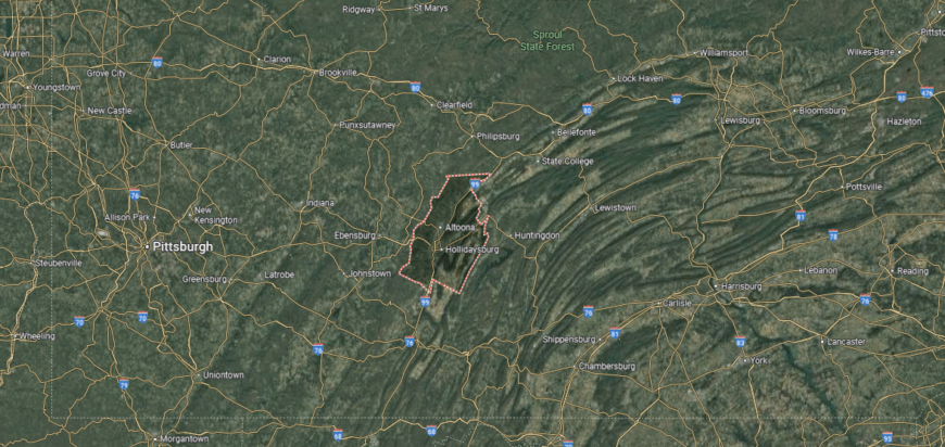
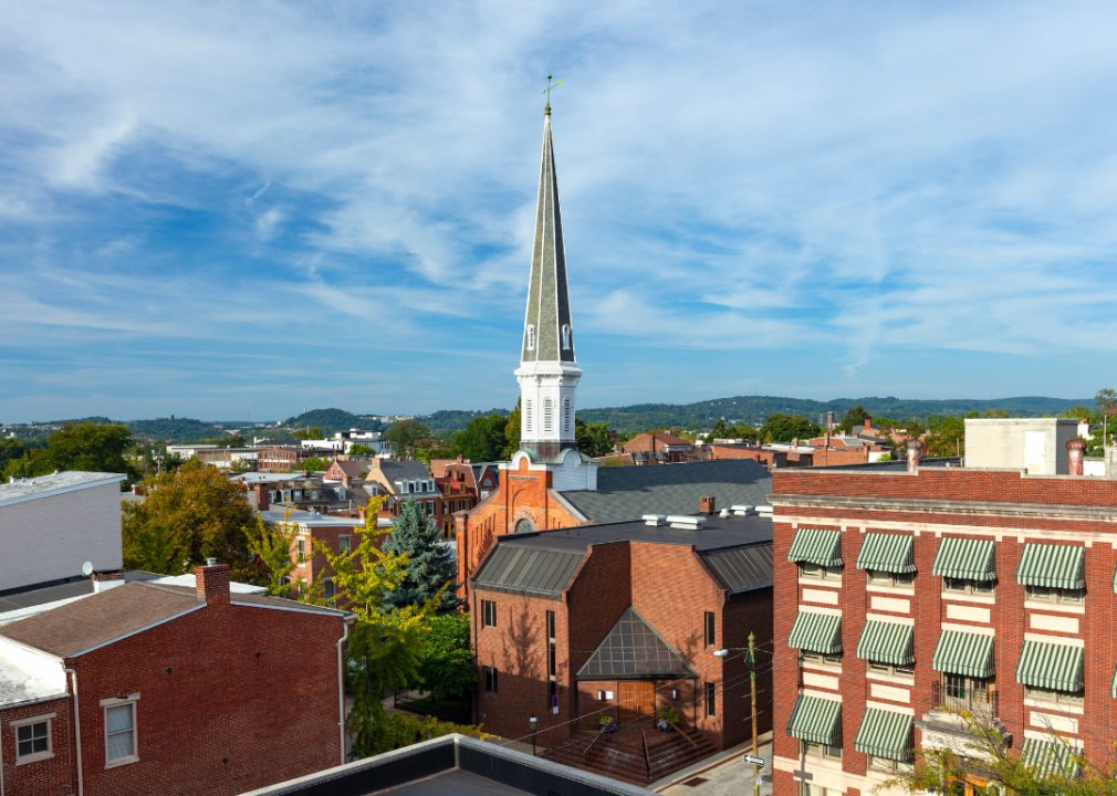
#25. Blair County, Pennsylvania
– Overall Rank: 1,231
– Population: 122,640
– Median household income: $59,386
– Median home value: $149,300 (72% own)
– Median rent: $838 (28% rent)
– Top public schools: Frankstown Elementary School (grade B+), Hollidaysburg Area Junior High School (grade B+), Tyrone Area Elementary School (grade B)
– Top private schools: Bishop Guilfoyle Catholic High School (grade B+), Great Commission Schools (grade B+), Blair County Christian School (grade B)
– Top places: Hollidaysburg (grade A), Blair Township (grade A minus), Frankstown Township (grade A minus)
About
Blair County’s economy is driven by healthcare, education, manufacturing, and retail, making it a stable hub in central Pennsylvania. Agriculture continues to play a role across rural areas, while logistics and services strengthen regional connections. Altoona, the county seat, anchors this base with hospitals, colleges, and government offices.
The county is also known for Horseshoe Curve, a landmark of its railroad heritage that still draws visitors today. Residents enjoy parks, trails, and cultural venues that add balance to daily life. With its mix of strong industries, historic identity, and outdoor access, Blair County maintains both opportunity and character.
Where is Blair County?
🔥 Would you like to save this?
Blair County is situated in central Pennsylvania, about 45 miles southwest of State College and 100 miles east of Pittsburgh. Anchored by Altoona, it lies in the Allegheny Mountains, where valleys and ridges create a dramatic setting in the state’s interior.
Interstate 99 runs north–south through the county, linking it to the broader I-80 corridor, while U.S. Routes 22 and 220 provide east–west access. Its location places it squarely in the heart of the Alleghenies, giving it both regional connectivity and the character of a mountain crossroads.
#24. Berks County, Pennsylvania
– Overall Rank: 1,193
– Population: 428,483
– Median household income: $74,617
– Median home value: $225,700 (71% own)
– Median rent: $1,078 (29% rent)
– Top public schools: West Reading Elementary Center (grade A), Wyomissing Hills Elementary Center (grade A), Wyomissing Area Junior/Senior High School (grade A minus)
– Top private schools: Blue Mountain Academy (grade A minus), The King’s Academy (grade A minus), Berks Catholic High School (grade A minus)
– Top places: Colony Park (grade A+), West Reading (grade A+), Whitfield (grade A)
About
Berks County sits in the rolling hills of southeastern Pennsylvania, with farmland, forests, and the Schuylkill River shaping its landscape. The economy is supported by manufacturing, healthcare, and education, while agriculture and small businesses remain vital across its townships. Reading, the county seat, provides hospitals, colleges, and cultural institutions that anchor the region.
Hawk Mountain Sanctuary, local trails, and parks that highlight the county’s natural setting. Festivals, fairs, and a strong Pennsylvania Dutch heritage add to its cultural identity. With its balance of scenic land, industry, and tradition, Berks County offers both opportunity and connection.
Where is Berks County?
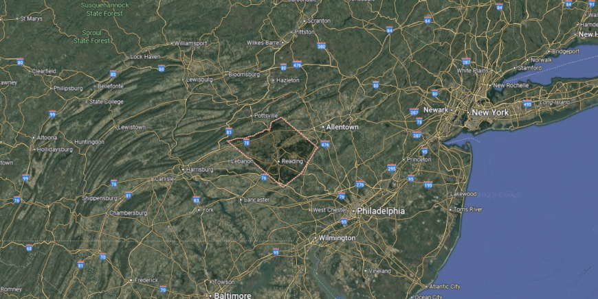
Berks County lies in southeastern Pennsylvania, with Reading as its county seat and largest city. It is about 60 miles northwest of Philadelphia and 35 miles southwest of Allentown, set within the Schuylkill River Valley and framed by the Blue Mountain ridge to the north.
U.S. Route 222 and Interstate 78 provide the main connections to the Lehigh Valley and beyond, while U.S. Route 422 links directly to the Philadelphia area. Its location gives it both the accessibility of the state’s urban corridor and the rural landscapes of Pennsylvania Dutch Country.
#23. York County, Pennsylvania
– Overall Rank: 1,134
– Population: 457,051
– Median household income: $79,183
– Median home value: $220,700 (76% own)
– Median rent: $1,094 (24% rent)
– Top public schools: York Haven Elementary School (grade A), Dallastown Elementary School (grade A), York Suburban Senior High School (grade A)
– Top private schools: York Country Day School (grade A+), Logos Academy (grade A minus), York Catholic Middle & High School (grade B+)
– Top places: Grantley (grade A), Valley View (grade A), East York (grade A)
About
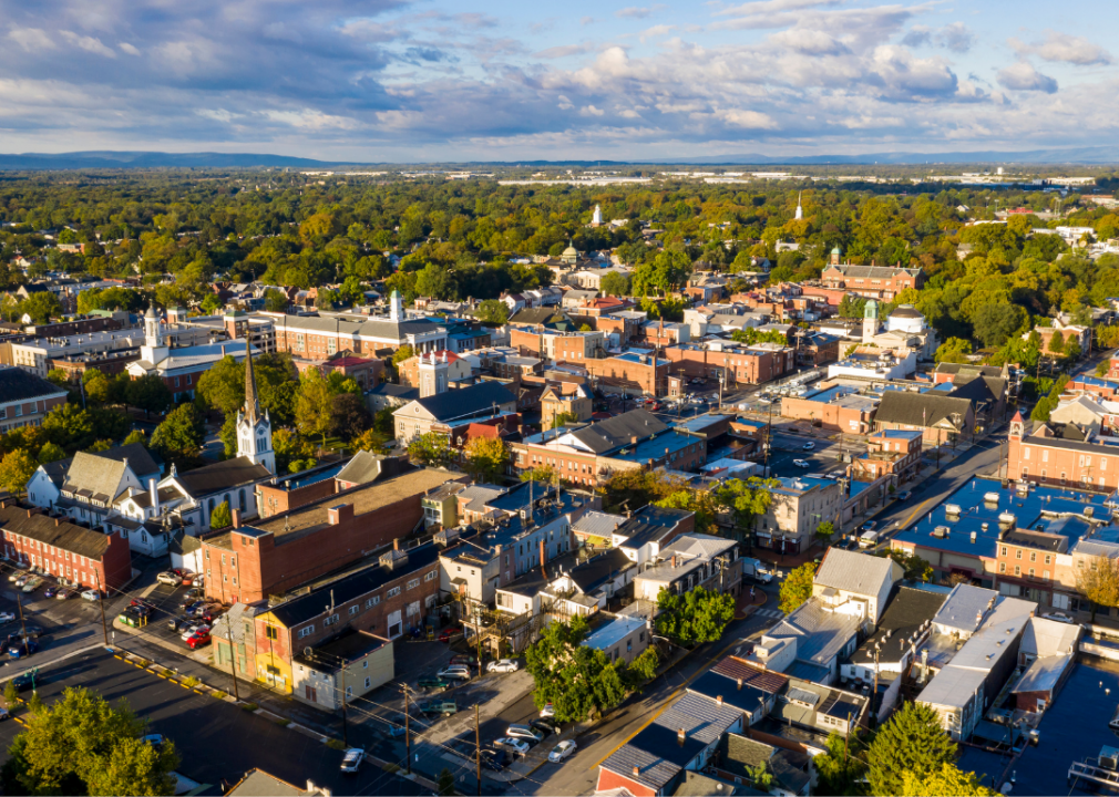
York County carries a strong heritage, from its role in the American Revolution to its long-standing Pennsylvania Dutch traditions. The economy has grown from early manufacturing into a mix of healthcare, logistics, agriculture, and modern industry, supported by both rural towns and urban centers. York, the county seat, provides hospitals, colleges, and cultural institutions that serve as regional anchors.
Residents enjoy fairs, farmers markets, and historic districts that tie present-day life to the county’s past. Outdoor opportunities range from Codorus State Park to trails along the Susquehanna River. With its deep cultural roots and diverse industries, York County blends history with opportunity.
Where is York County?
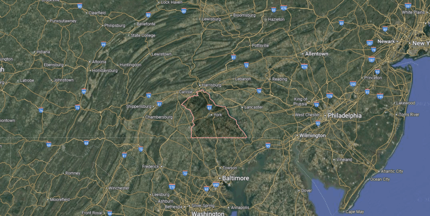
York County is positioned in south-central Pennsylvania, bordering Maryland to the south. It lies about 25 miles south of Harrisburg and 50 miles north of Baltimore, giving it a strategic location in the Susquehanna River Valley.
Interstate 83 runs north–south through the county, directly connecting it to both Harrisburg and Baltimore, while U.S. Route 30 provides the main east–west route. Its location makes it both a commuter hub for larger cities and a gateway to the rolling farmland and historic towns of Pennsylvania’s countryside.
#22. Monroe County, Pennsylvania
– Overall Rank: 1,103
– Population: 168,128
– Median household income: $80,656
– Median home value: $221,100 (79% own)
– Median rent: $1,311 (21% rent)
– Top public schools: Stroudsburg High School (grade A minus), Pocono Mountain East High School (grade A minus), Pocono Mountain West High School (grade B+)
– Top private schools: Notre Dame Junior/Senior High School (grade A), Gregory the Great Academy (grade B minus), Notre Dame Elementary School (grade unavailable)
– Top places: Smithfield Township (grade B+), Pocono Township (grade B+), Coolbaugh Township (grade B+)
About
Monroe County is anchored by Stroudsburg, the county seat, which serves as a hub for government, healthcare, and education. The economy is shaped by tourism tied to the Pocono Mountains, along with retail, services, and a growing logistics sector. Other communities like East Stroudsburg, Mount Pocono, and Tannersville add schools, businesses, and cultural activity.
Resorts, ski slopes, and state parks that define the county’s reputation as a recreation destination. Festivals, outlet shopping, and historic districts add to its appeal for both locals and visitors. With its balance of tourism, community life, and natural setting, Monroe County thrives as a gateway to the Poconos.
Where is Monroe County?

Monroe County sits in northeastern Pennsylvania, about 40 miles north of Allentown and 75 miles west of New York City. It lies within the Pocono Mountains, with a landscape shaped by forested ridges, lakes, and valleys that attract visitors year-round.
Interstate 80 runs directly through the county, serving as its main east–west artery, while U.S. Route 209 connects its smaller towns along the Delaware Water Gap. Its location places it at the edge of the New York metropolitan area, making it both a mountain retreat and a commuter link to the city.
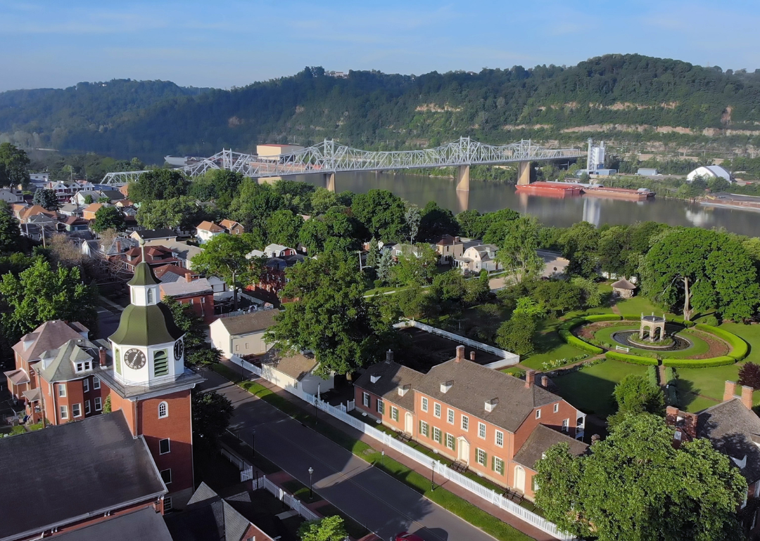
#21. Columbia County, Pennsylvania
– Overall Rank: 1,072
– Population: 64,924
– Median household income: $59,457
– Median home value: $183,200 (71% own)
– Median rent: $862 (29% rent)
– Top public schools: Central Columbia Middle School (grade A), Central Columbia Elementary School (grade A), Central Columbia Senior High School (grade A minus)
– Top private schools: Columbia County Christian School (grade C+), Bloomsburg Christian School (grade C+), New Story School (grade unavailable)
– Top places: Espy (grade A), Orange Township (grade A minus), Mount Pleasant Township (grade A minus)
You may also like: Best-performing Pennsylvania stocks last week
About
Life in Columbia County is shaped by its close-knit communities, where schools, local fairs, and small businesses connect residents across towns and countryside. Bloomsburg, the county seat, anchors the region with Bloomsburg University, healthcare services, and cultural venues. Smaller boroughs like Berwick and Catawissa add their own traditions through festivals, markets, and neighborhood ties.
The economy is supported by education, manufacturing, and healthcare, while agriculture continues to play a role in the rural townships. Residents enjoy access to the Susquehanna River, nearby state parks, and events that celebrate both history and community pride. With its steady industries and strong community life, Columbia County balances opportunity with tradition.
Where is Columbia County?
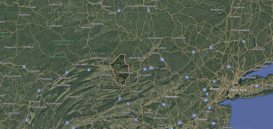
Columbia County is located in east-central Pennsylvania, about 45 miles northeast of Harrisburg and 55 miles southwest of Scranton. Anchored by Bloomsburg, the only incorporated town in the state, it sits along the Susquehanna River’s North Branch where valleys meet wooded ridges.
Interstate 80 cuts across the county, providing a major east–west route, while U.S. Routes 11 and 487 connect its river towns and rural communities. Its location places it within the heart of the Susquehanna Valley, balanced between Pennsylvania’s northern mountains and central lowlands.
#20. Beaver County, Pennsylvania
– Overall Rank: 1,070
– Population: 167,629
– Median household income: $67,194
– Median home value: $170,900 (74% own)
– Median rent: $830 (26% rent)
– Top public schools: Dutch Ridge Elementary School (grade A minus), Beaver Area Middle School (grade B+), Lincoln Park Performing Arts Charter School (grade B+)
– Top private schools: Beaver County Christian School (grade B), Beaver Co Christian School – Middle Campus (grade unavailable), Our Lady of Fatima Elementary School (grade unavailable)
– Top places: Beaver (grade A), Chippewa Township (grade A minus), Brighton Township (grade A minus)

About
Beaver County sits where the Ohio, Beaver, and Connoquenessing Rivers meet, shaping both its landscape and its history. The economy combines manufacturing, healthcare, and energy with growing service and technology sectors. Beaver, the county seat, joins communities like Aliquippa, Ambridge, and Monaca in providing schools, businesses, and cultural life.
Residents enjoy riverfront parks, historic districts, and trails that highlight the county’s setting near Pittsburgh. Annual festivals and community events connect towns while celebrating local heritage. With its rivers, industries, and strong neighborhoods, Beaver County links natural scenery with opportunity.
Where is Beaver County?
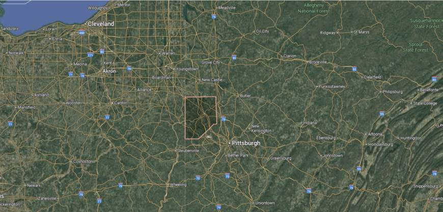
Beaver County sits in western Pennsylvania along the Ohio River, about 30 miles northwest of Pittsburgh. Its position places it at the edge of the Pittsburgh metropolitan area while still tied to the rolling hills and river valleys of the region.
Interstate 376 links the county directly to Pittsburgh, while the Pennsylvania Turnpike (Interstate 76) crosses its southern edge for broader east–west access. Its location makes it both a commuter gateway into the city and a hub along the Ohio River corridor.
#19. Washington County, Pennsylvania
– Overall Rank: 1,030
– Population: 209,631
– Median household income: $74,403
– Median home value: $205,600 (76% own)
– Median rent: $879 (24% rent)
– Top public schools: Peters Township Middle School (grade A), Peters Township High School (grade A), Bower Hill Elementary School (grade A)
– Top private schools: First Love Christian Academy (grade A minus), Faith Christian School (grade C+), Tri-State Christian Academy (grade B minus)
– Top places: McMurray (grade A+), Thompsonville (grade A), Canonsburg (grade A minus)
About
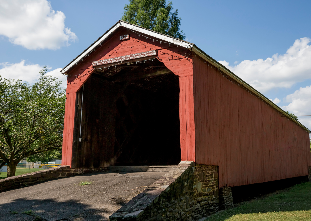
Washington County traces its history to the Whiskey Rebellion of the 1790s, a defining moment in early American politics. The economy has shifted from coal mining and steel to a mix of energy, healthcare, manufacturing, and education. Washington, the county seat, anchors this base with schools, hospitals, and cultural venues, while towns like Canonsburg and Monongahela add their own industries and traditions.
Visitors enjoy historic sites, fairs, and events like the annual Covered Bridge Festival that celebrate local heritage. Outdoor recreation includes parks, trails, and rivers that connect people to the land. With its blend of history, strong industries, and community pride, Washington County remains both rooted and resilient.
Where is Washington County?
🔥 Would you like to save this?
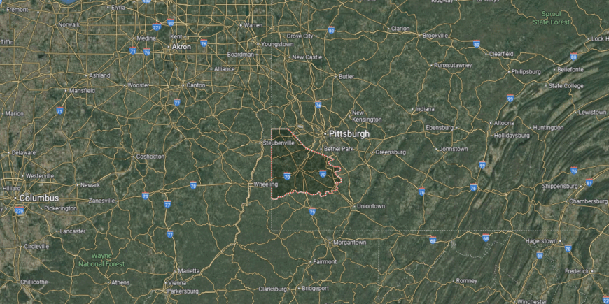
Washington County is located in southwestern Pennsylvania, just south of Pittsburgh. It borders West Virginia to the southwest and lies about 30 miles north of the Ohio River at Wheeling, placing it in a crossroads position near two state lines.
Interstate 70 and Interstate 79 intersect within the county, giving it direct north–south and east–west connections across the region. Its location makes it a key link between Pittsburgh, the Ohio Valley, and northern West Virginia, while still defined by rolling hills and historic small towns.
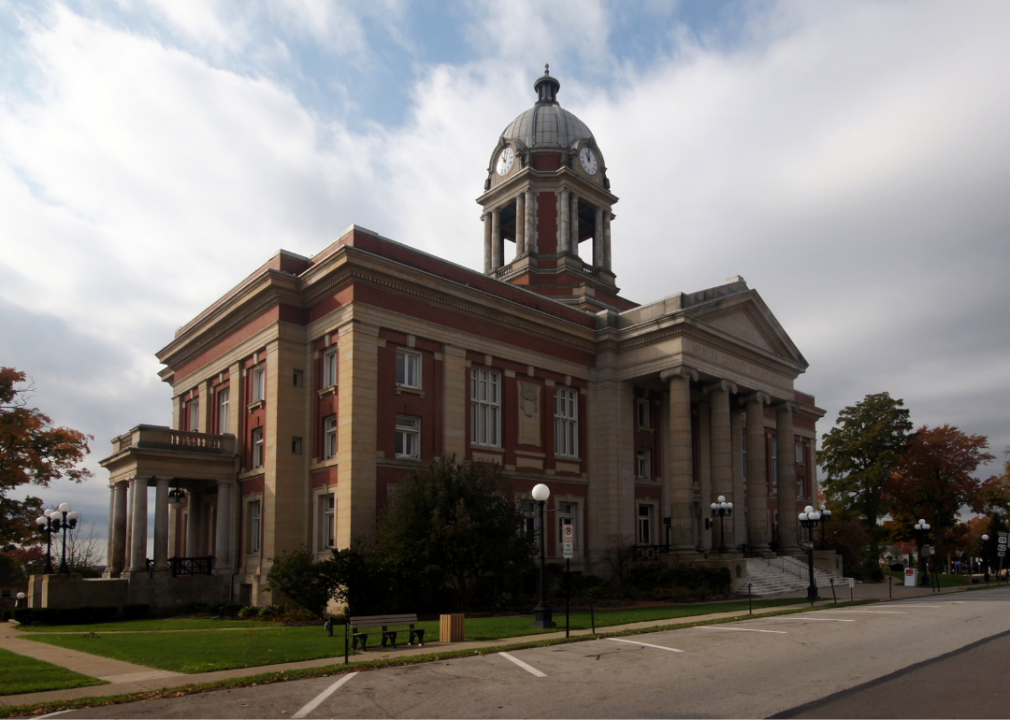
#18. Mercer County, Pennsylvania
– Overall Rank: 991
– Population: 110,600
– Median household income: $57,353
– Median home value: $146,100 (72% own)
– Median rent: $761 (28% rent)
– Top public schools: Delahunty Middle School (grade A), Artman Elementary School (grade A minus), Karen A. Ionta Elementary School (grade B+)
– Top private schools: Kennedy Catholic High School (grade A minus), Saint John Paul II Elementary School (grade A+), Grove City Christian Academy (grade B+)
– Top places: Grove City (grade A), Pine Township (grade B+), Hermitage (grade B+)
About
Mercer County is anchored by Mercer, the county seat, with Sharon, Hermitage, and Grove City serving as additional centers of commerce and community. The economy is supported by manufacturing, healthcare, retail, and education, with Grove City College and shopping outlets drawing regional activity. Agriculture also continues to play a role in the county’s rural areas.
Local parks, golf courses, and cultural venues spread across its towns. Festivals, fairs, and historic sites add to community life while reinforcing regional identity. With its balanced industries and accessible location, Mercer County serves as both a workplace and a destination in western Pennsylvania.
Where is Mercer County?
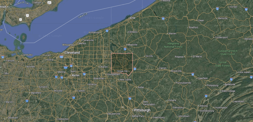
Mercer County is found in western Pennsylvania, about 60 miles north of Pittsburgh and 75 miles southeast of Cleveland. It sits along the Ohio border, giving it strong ties to both Pennsylvania’s interior and northeastern Ohio.
Interstate 80 runs east–west across the county, while Interstate 79 provides a north–south connection, making it a well-traveled junction in the region. Its location places it at the meeting point of two states, balancing rural landscapes with easy access to larger metropolitan areas.
#17. Union County, Pennsylvania
– Overall Rank: 756
– Population: 42,908
– Median household income: $64,914
– Median home value: $210,300 (72% own)
– Median rent: $899 (28% rent)
– Top public schools: Donald H. Eichhorn Middle School (grade A), Kelly Elementary School (grade A), Linntown Elementary School (grade A)
– Top private schools: Shady Grove Christian School (grade unavailable), Buffalo Creek Parochial School (grade unavailable), Morning Star Mennonite School (grade unavailable)
– Top places: Linntown (grade A), Lewisburg (grade A), West Buffalo Township (grade B)
About
Union County is centered on close-knit communities where schools, local markets, and small businesses shape daily life. Lewisburg, the county seat, adds vibrancy with Bucknell University, healthcare services, and cultural institutions that anchor the region. Towns like Mifflinburg and New Berlin contribute festivals, historic districts, and neighborhood traditions.
The economy balances education, manufacturing, and healthcare with farming that remains important in rural areas. Residents enjoy parks, riverfront trails along the Susquehanna, and events that celebrate both history and community spirit. With its mix of strong community ties, industries, and culture, Union County blends small-town living with regional opportunity.
Where is Union County?
Union County is situated in central Pennsylvania, about 50 miles north of Harrisburg and 60 miles east of State College. It lies in the Susquehanna River Valley, with the river forming much of its eastern boundary and forested ridges rising to the west.
U.S. Route 15 provides the main north–south corridor, while Interstate 80 crosses just north of the county line, linking it to the broader region. Its location gives it a mix of accessibility and seclusion, with Lewisburg as the county seat anchoring this stretch of the valley.
#16. Erie County, Pennsylvania
– Overall Rank: 665
– Population: 270,495
– Median household income: $59,396
– Median home value: $160,200 (68% own)
– Median rent: $851 (32% rent)
– Top public schools: Northwest Pennsylvania Collegiate Academy (grade A+), Robison Elementary School (grade A), Fairview Elementary School (grade A)
– Top private schools: Mercyhurst Preparatory School (grade A), Cathedral Preparatory School (grade A minus), Erie First Christian Academy (grade B+)
– Top places: Fairview (grade A minus), Millcreek Township (grade A minus), Harborcreek Township (grade A minus)
You may also like: Bestselling cars in Pennsylvania
About
Erie County stretches along Lake Erie, where Presque Isle State Park, sandy beaches, and harbors define both its landscape and recreation. The economy is driven by healthcare, education, and manufacturing, while tourism tied to the lakefront adds seasonal strength. Erie, the county seat, anchors the region with universities, hospitals, and cultural institutions.
Residents enjoy boating, fishing, and trails along the shoreline, as well as festivals and sporting events that bring the community together. Smaller towns like North East, Fairview, and Edinboro add wineries, schools, and local traditions. With its mix of lakefront beauty, industry, and culture, Erie County thrives as a hub of northwest Pennsylvania.
Where is Erie County?
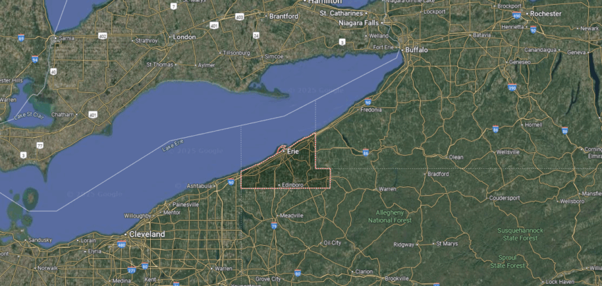
Erie County sits in the far northwestern corner of Pennsylvania, bordered by Lake Erie to the north, Ohio to the west, and New York to the east. The city of Erie serves as its hub, about 100 miles southwest of Buffalo and 125 miles north of Pittsburgh.
Interstate 90 runs east–west across the county, while Interstates 79 and 86 connect it south toward Pittsburgh and east into New York. Its location on the Great Lakes shoreline makes it Pennsylvania’s only lakefront county, serving as both a shipping gateway and a regional center between three states.
#15. Westmoreland County, Pennsylvania
– Overall Rank: 658
– Population: 354,414
– Median household income: $69,454
– Median home value: $181,600 (78% own)
– Median rent: $822 (22% rent)
– Top public schools: Franklin Regional Senior High School (grade A), Franklin Regional Primary School (grade A), Franklin Regional Middle School (grade A)
– Top private schools: The Kiski School (grade A+), Greensburg Central Catholic High School (grade B+), Grace Bible Academy (grade B)
– Top places: Murrysville (grade A+), North Huntingdon Township (grade A), Manor (grade A)
About
Westmoreland County traces its history to the colonial era as one of Pennsylvania’s earliest counties, with a legacy tied to frontier settlement and industry. Manufacturing, healthcare, and education now anchor the economy, while agriculture remains important in rural areas. Greensburg, the county seat, provides schools, hospitals, and cultural venues, and towns like Latrobe and Jeannette contribute their own traditions.
Historic sites, museums, and events highlight the county’s role in Pennsylvania’s growth. Residents also enjoy access to parks, trails, and the Laurel Highlands, which bring both recreation and tourism. With its mix of history, industry, and scenic settings, Westmoreland County blends heritage with opportunity.
Where is Westmoreland County?
Westmoreland County is located in southwestern Pennsylvania, about 30 miles east of Pittsburgh. It stretches from the edges of the Pittsburgh metropolitan area into the Laurel Highlands, where rolling farmland transitions into forested hills and ridges.
U.S. Route 30 serves as the main east–west corridor, while the Pennsylvania Turnpike (Interstate 76) cuts across the county, linking it to both Harrisburg and Ohio. Its location places it at the gateway between the urban influence of Pittsburgh and the scenic mountain landscapes of western Pennsylvania.
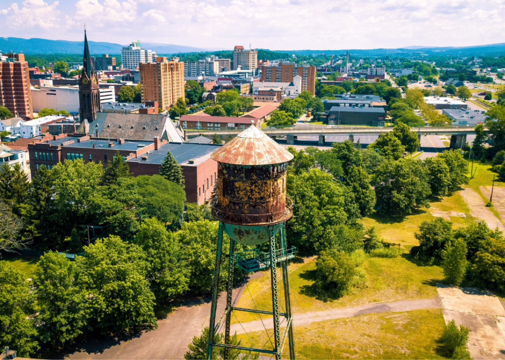
#14. Lackawanna County, Pennsylvania
– Overall Rank: 544
– Population: 215,672
– Median household income: $63,739
– Median home value: $175,700 (65% own)
– Median rent: $917 (35% rent)
– Top public schools: Waverly School (grade A), South Abington School (grade A minus), Moscow Elementary School (grade A minus)
– Top private schools: Scranton Preparatory School (grade A), Holy Cross High School (grade B+), Triboro Christian Academy (grade C)
– Top places: Clarks Summit (grade A), Chinchilla (grade A), Clarks Green (grade A)
🔥 Would you like to save this?
About
Lackawanna County is known for attractions like the Steamtown National Historic Site, local theaters, and events that showcase its cultural energy. The economy has shifted from coal mining to a base of healthcare, education, logistics, and services that sustain the region. Scranton, the county seat, anchors this activity with universities, hospitals, and government offices, while towns like Dunmore, Old Forge, and Carbondale add their own identity.
Skiing in the nearby Poconos, trails and parks across the valley, and festivals highlight both heritage and community pride. Historic architecture and museums connect present life with the county’s industrial past. With its blend of cultural attractions, recreation, and steady industries, Lackawanna County continues to serve as a hub of northeastern Pennsylvania.
Where is Lackawanna County?
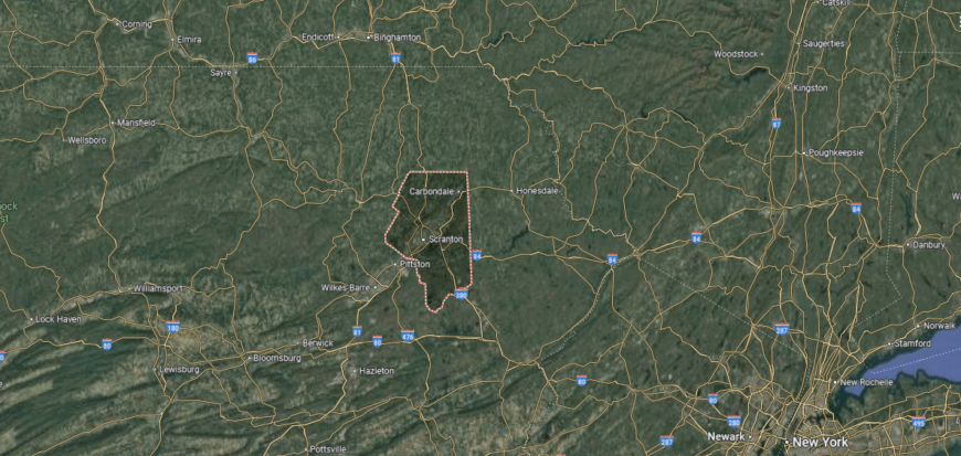
Lackawanna County is positioned in northeastern Pennsylvania, with Scranton as its county seat and largest city. It lies about 15 miles north of Wilkes-Barre and 120 miles northwest of New York City, resting in the Lackawanna River Valley amid the Pocono and Endless Mountains.
Interstate 81 runs north–south through the county, while Interstates 84 and 380 provide direct links eastward toward New York and New Jersey. Its location makes it a hub of the Scranton–Wilkes-Barre metropolitan area and a gateway between Pennsylvania’s mountain country and the greater New York region.
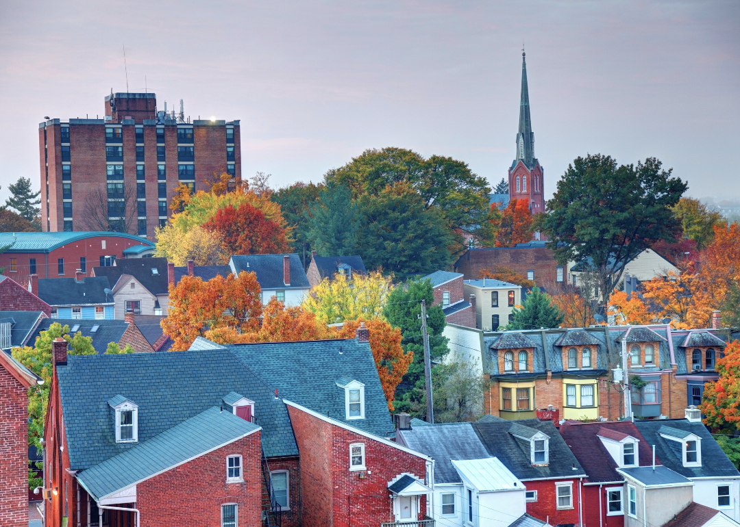
#13. Butler County, Pennsylvania
– Overall Rank: 534
– Population: 194,562
– Median household income: $82,932
– Median home value: $258,500 (76% own)
– Median rent: $978 (24% rent)
– Top public schools: Rowan Elementary School (grade A minus), Haine Middle School (grade A minus), Ehrman Crest Elementary School (grade A minus)
– Top private schools: North Catholic High School (grade A minus), First Baptist Christian School (grade B minus), Portersville Christian School (grade B minus)
– Top places: Cranberry Township (grade A), Seven Fields (grade A), Harmony (grade A minus)
About
Butler County’s economy is supported by manufacturing, healthcare, and education, with small businesses and retail adding stability across its towns. Agriculture remains important in rural areas, while technology and services have grown closer to the Pittsburgh metro region. Butler, the county seat, anchors the area with hospitals, schools, and civic institutions.
Residents enjoy Moraine State Park, historic districts, and local festivals that bring communities together. Towns such as Cranberry Township, Zelienople, and Slippery Rock contribute their own strengths through universities, cultural venues, and neighborhood traditions. With its mix of industry, farmland, and recreation, Butler County balances growth with small-town identity.
Where is Butler County?
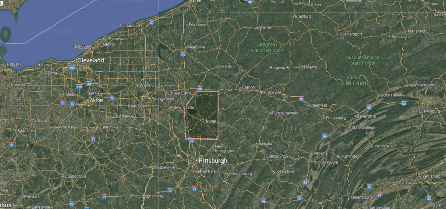
Butler County sits in western Pennsylvania, about 30 miles north of Pittsburgh. It marks the transition from the Pittsburgh metropolitan area into the rolling hills and farmland of the state’s interior.
Interstate 79 runs along its western edge, connecting it directly to Pittsburgh and Erie, while U.S. Route 422 cuts east–west through the county. Its location gives it both the accessibility of a growing suburban region and the open landscapes of rural western Pennsylvania.
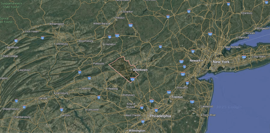
#12. Northampton County, Pennsylvania
– Overall Rank: 522
– Population: 314,299
– Median household income: $82,201
– Median home value: $265,600 (71% own)
– Median rent: $1,280 (29% rent)
– Top public schools: The Lehigh Valley Charter High School for the Arts (grade A), Nazareth Area High School (grade A), Nazareth Area Intermediate School (grade A minus)
– Top private schools: Moravian Academy (grade A+), Notre Dame High School (grade A minus), Faith Christian School (grade A minus)
– Top places: Tatamy (grade A), Lower Nazareth Township (grade A), Forks Township (grade A minus)
About
Northampton County stretches along the Lehigh River and Delaware River, with rolling hills and fertile farmland shaping much of its landscape. The economy is supported by healthcare, education, logistics, and advanced manufacturing, while agriculture and small businesses remain steady contributors. Easton, the county seat, provides schools, hospitals, and cultural venues, while Bethlehem and Nazareth add historic districts and strong community ties.
Locals enjoy parks, riverfront trails, and easy access to the Appalachian Trail and Delaware Water Gap. Festivals, farmers markets, and museums highlight both heritage and culture across the county’s towns. With its blend of natural settings, industry, and traditions, Northampton County connects scenic beauty with economic opportunity.
Where is Northampton County?
Northampton County is found in eastern Pennsylvania, bordering New Jersey along the Delaware River. It lies about 70 miles north of Philadelphia and 70 miles west of New York City, with Easton as its county seat and Bethlehem as one of its major cities.
Interstate 78 and U.S. Route 22 provide the main east–west routes, linking the county directly to both New York and Philadelphia. Its location places it in the heart of the Lehigh Valley, a region that blends historic river towns with growing metropolitan connections.
#11. Lancaster County, Pennsylvania
– Overall Rank: 445
– Population: 553,202
– Median household income: $81,458
– Median home value: $263,600 (70% own)
– Median rent: $1,221 (30% rent)
– Top public schools: Nitrauer School (grade A), Reidenbaugh Elementary School (grade A), Landis Run Intermediate School (grade A)
– Top private schools: Linden Hall (grade A+), Lancaster Country Day School (grade A+), Veritas Academy (grade A)
– Top places: Manheim Township (grade A), East Hempfield Township (grade A), Landisville (grade A)
You may also like: Fastest-growing jobs in Pennsylvania
About
Lancaster County is deeply tied to its Pennsylvania Dutch heritage, from Amish farmland to historic towns that preserve early American traditions. Agriculture remains central to the economy, supported by manufacturing, healthcare, and tourism that thrives on the county’s cultural identity. Lancaster, the county seat, offers schools, hospitals, and vibrant markets, while towns like Ephrata, Lititz, and Strasburg add their own historic character.
Residents and visitors enjoy covered bridges, farmland tours, and festivals that celebrate local crafts and foods. Outdoor recreation along the Susquehanna River and in county parks adds balance to daily life. With its blend of heritage, strong industries, and rural beauty, Lancaster County connects tradition with opportunity.
Where is Lancaster County?
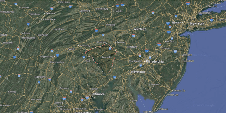
Lancaster County lies in southeastern Pennsylvania, about 70 miles west of Philadelphia and 40 miles east of Harrisburg. It stretches across the fertile farmlands of the Susquehanna River Valley and is widely recognized as the heart of Pennsylvania Dutch Country.
U.S. Route 30 serves as the major east–west corridor, while U.S. Route 222 and the Pennsylvania Turnpike (Interstate 76) provide strong north–south and regional links. Its location places it at the crossroads of rural tradition and urban accessibility, balancing agricultural landscapes with proximity to major East Coast cities.
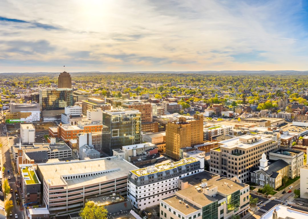
#10. Lehigh County, Pennsylvania
– Overall Rank: 429
– Population: 374,110
– Median household income: $74,973
– Median home value: $254,500 (65% own)
– Median rent: $1,259 (35% rent)
– Top public schools: Fred J. Jaindl Elementary School (grade A), Veterans Memorial Elementary School (grade A), Parkland High School (grade A)
– Top private schools: Allentown Central Catholic High School (grade A), Lehigh Christian Academy (grade B), Salem Christian School (grade B minus)
– Top places: Trexlertown (grade A+), Breinigsville (grade A), Dorneyville (grade A)
About
Lehigh County is anchored by Allentown, the county seat and third-largest city in Pennsylvania, which serves as a hub for healthcare, education, and cultural life. The economy is powered by logistics, manufacturing, and services, strengthened by the county’s location along major transportation corridors. Communities such as Emmaus, Macungie, and Whitehall add schools, businesses, and strong neighborhood traditions.
Allentown offers hospitals, colleges, and arts venues that shape the county’s identity. Residents enjoy Coca-Cola Park, the Allentown Art Museum, and a network of parks and trails that connect city and countryside. With its mix of urban energy, economic strength, and suburban communities, Lehigh County stands as a key center in eastern Pennsylvania.
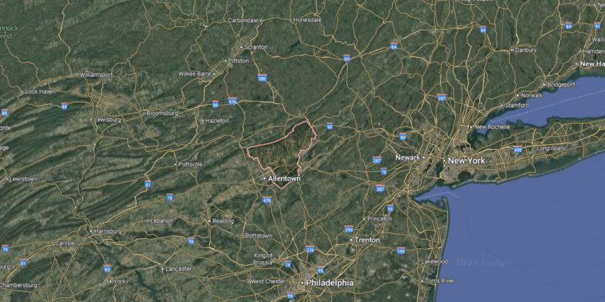
Where is Lehigh County?
Lehigh County is located in eastern Pennsylvania, with Allentown as its county seat and largest city. It sits about 60 miles north of Philadelphia and 90 miles west of New York City, anchoring the center of the Lehigh Valley.
Interstate 78 runs east–west through the county, linking it directly to both Philadelphia and New York, while U.S. Route 22 provides a key regional route across the valley. Its location gives it a blend of metropolitan accessibility and valley landscapes, making it a central hub within eastern Pennsylvania.
#9. Montour County, Pennsylvania
– Overall Rank: 271
– Population: 18,165
– Median household income: $72,626
– Median home value: $227,800 (70% own)
– Median rent: $998 (30% rent)
– Top public schools: Danville Area Middle School (grade A minus), Danville Area Senior High School (grade A minus), Liberty-Valley Elementary School (grade A minus)
– Top private schools: St. Joseph School (grade unavailable), St. Cyril Preschool & Kindergarten (grade unavailable), Creek Side School (grade unavailable)
– Top places: Danville (grade A), Valley Township (grade A minus), Mahoning Township (grade B+)
About
Montour County is shaped by its close-knit communities, where schools, local businesses, and traditions tie residents together. Danville, the county seat, serves as the center for healthcare, education, and civic life, while surrounding townships contribute their own rural identity. Daily life here blends small-town connections with access to the Susquehanna River and nearby countryside.
The economy is anchored by healthcare, with Geisinger Medical Center playing a major role, along with agriculture and small manufacturing. Residents enjoy parks, riverfront activities, and community events that highlight the county’s character. With its strong community spirit and balance of work and recreation, Montour County offers both stability and connection.
Where is Montour County?
Montour County is set in east-central Pennsylvania, about 60 miles north of Harrisburg and 55 miles southwest of Scranton. It is the smallest county in the state by land area, centered around Danville along the North Branch of the Susquehanna River.
U.S. Route 11 and State Route 54 provide the main travel corridors, linking the county to surrounding regions and larger highways like Interstate 80 just to the north. Its location in the Susquehanna Valley gives it both accessibility and a compact, close-knit character.
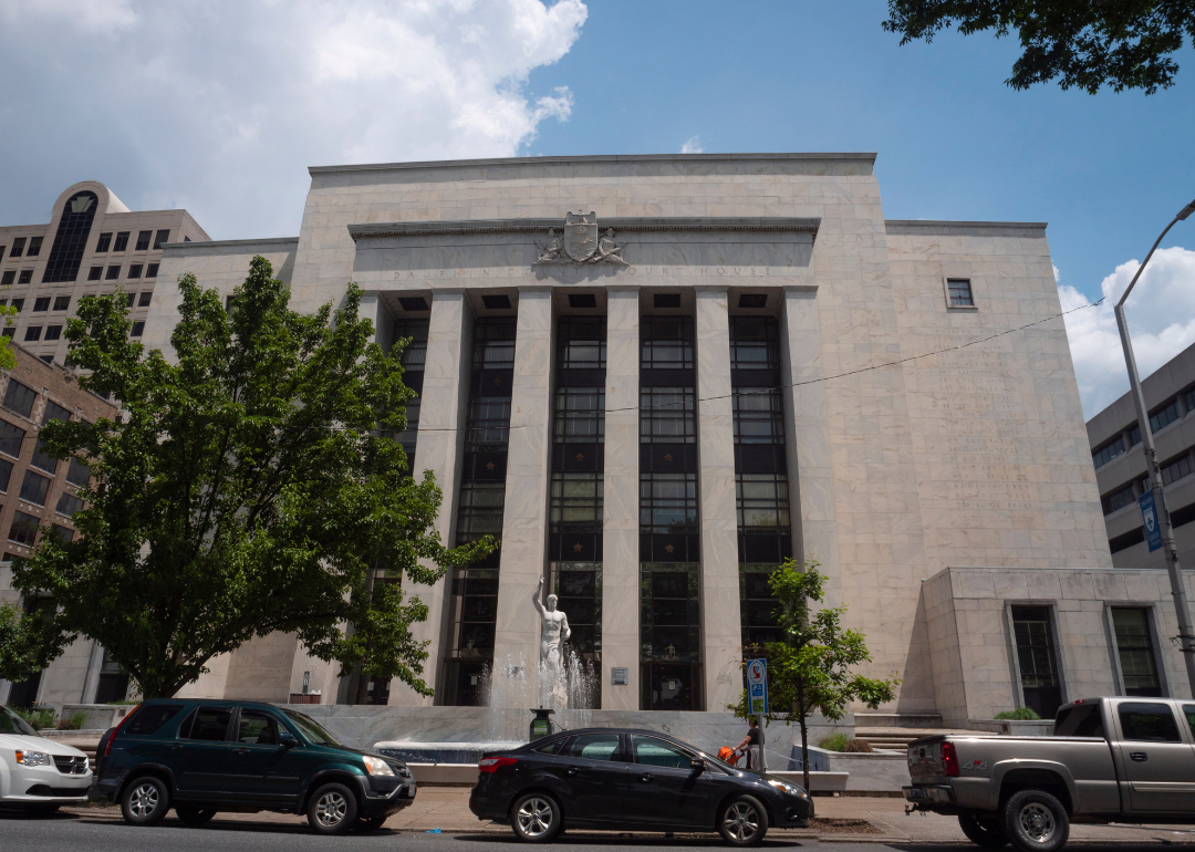
#8. Dauphin County, Pennsylvania
– Overall Rank: 243
– Population: 286,108
– Median household income: $71,046
– Median home value: $208,200 (63% own)
– Median rent: $1,090 (37% rent)
– Top public schools: Hershey Middle School (grade A+), Hershey High School (grade A+), Infinity Charter School (grade A+)
– Top private schools: Covenant Christian Academy (grade A), Bishop McDevitt High School (grade A minus), Milton Hershey School (grade B+)
– Top places: Hershey (grade A), Penbrook (grade A), Middle Paxton Township (grade A minus)
About
Dauphin County stretches from the Susquehanna River through wooded hills and state parks that shape both its scenery and recreation. The economy is supported by government, healthcare, and education, with Harrisburg, the state capital and county seat, serving as the hub for civic and cultural life. Other communities like Hershey and Middletown add their own strengths through industry, tourism, and tradition.
Residents enjoy trails, riverfront parks, and attractions such as Hersheypark and the Pennsylvania State Capitol. Festivals, historic sites, and local markets tie together city energy with small-town pride. With its combination of natural beauty, strong institutions, and cultural landmarks, Dauphin County stands as both a destination and a center of opportunity.
Where is Dauphin County?
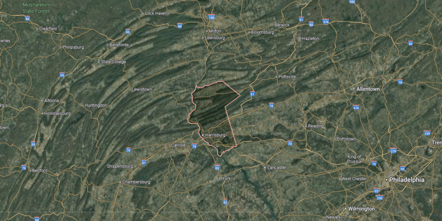
Dauphin County is positioned in south-central Pennsylvania, with Harrisburg—the state capital—serving as its hub. It lies about 105 miles west of Philadelphia and 200 miles east of Pittsburgh, stretching from the Susquehanna River Valley northward into the ridges of the Appalachian Mountains.
Interstate 81 and Interstate 83 provide key north–south routes, while the Pennsylvania Turnpike (Interstate 76) runs east–west across the county. Its location places it at the center of state government and transportation, bridging urban corridors with mountain landscapes.
#7. Bucks County, Pennsylvania
– Overall Rank: 199
– Population: 645,163
– Median household income: $107,826
– Median home value: $395,800 (78% own)
– Median rent: $1,461 (22% rent)
– Top public schools: Central Bucks High School – East (grade A+), Bucks County Montessori Charter School (grade A+), Central Bucks High School – West (grade A+)
– Top private schools: George School (grade A+), Solebury School (grade A+), Holy Ghost Preparatory School (grade A+)
– Top places: Buckingham Township (grade A+), Doylestown Township (grade A+), Newtown (grade A+)
About
Bucks County carries deep historical roots, from Washington’s crossing of the Delaware River to preserved colonial towns that reflect its role in early America. The economy blends suburban growth with healthcare, education, and services, while agriculture and tourism remain steady contributors. Doylestown, the county seat, anchors the region with cultural institutions, schools, and government services, while towns like Newtown and Quakertown add their own historic character.
Residents and visitors enjoy covered bridges, river towns, and arts festivals that highlight the county’s heritage. Outdoor opportunities range from Delaware Canal State Park to trails and preserved farmland. With its mix of history, cultural life, and strong industries, Bucks County connects tradition with modern vitality.
Where is Bucks County?
Bucks County sits in southeastern Pennsylvania, bordering both New Jersey and the northern edge of the Philadelphia metropolitan area. It lies about 25 miles northeast of Philadelphia and 75 miles southwest of New York City, with the Delaware River forming much of its eastern boundary.
Interstate 95 and U.S. Route 1 run along the county’s eastern corridor, while the Pennsylvania Turnpike (Interstate 276) provides a major east–west link. Its location makes it both a gateway to Philadelphia and a corridor to New Jersey and New York, blending suburban communities with historic river towns.
#6. Cumberland County, Pennsylvania
– Overall Rank: 188
– Population: 261,269
– Median household income: $82,849
– Median home value: $246,200 (70% own)
– Median rent: $1,146 (30% rent)
– Top public schools: Winding Creek Elementary School (grade A), Shaull Elementary School (grade A), Hampden Elementary School (grade A)
– Top private schools: Harrisburg Academy (grade A+), Trinity High School (grade A minus), Heritage Christian Academy (grade A minus)
– Top places: Camp Hill (grade A+), Hampden Township (grade A+), Upper Allen Township (grade A)
You may also like: Best places to live in Pennsylvania
About
Cumberland County’s economy is driven by logistics, manufacturing, and healthcare, strengthened by its position along the I-81 corridor. Agriculture remains an important part of the county, with dairy and crop farming sustaining its rural areas. Carlisle, the county seat, anchors the region with schools, hospitals, and government services, while towns like Mechanicsburg and Shippensburg add their own industries and traditions.
State parks, trails, and historic landmarks across the Cumberland Valley are best places to enjoy. Events like car shows in Carlisle and community festivals connect people throughout the year. With its mix of strong industries, farming, and culture, Cumberland County blends economic vitality with local identity.
Where is Cumberland County?
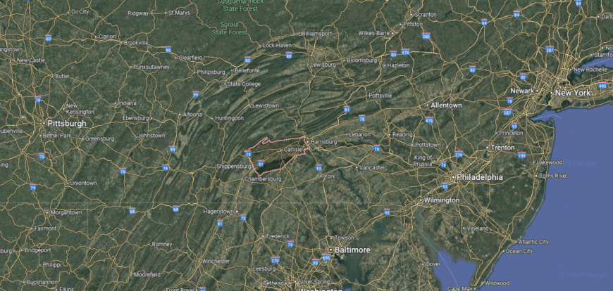
Cumberland County is located in south-central Pennsylvania, just west of Harrisburg across the Susquehanna River. It lies about 120 miles northwest of Baltimore and 110 miles west of Philadelphia, stretching across the fertile Cumberland Valley.
Interstate 81 runs north–south through the county, while the Pennsylvania Turnpike (Interstate 76) cuts east–west, making it one of the state’s most accessible crossroads. Its location places it at the heart of the valley, balancing rural landscapes with its close proximity to the state capital.
#5. Centre County, Pennsylvania
– Overall Rank: 169
– Population: 158,665
– Median household income: $70,087
– Median home value: $289,800 (63% own)
– Median rent: $1,118 (37% rent)
– Top public schools: State College Area High School (grade A+), Corl Street Elementary School (grade A+), Radio Park Elementary School (grade A+)
– Top private schools: Centre County Christian Academy (grade A), Grace Prep High School (grade A), Saint Joseph’s Catholic Academy (grade B+)
– Top places: Houserville (grade A+), Boalsburg (grade A+), Park Forest Village (grade A+)
About
Centre County lies in the heart of the Alleghenies, with valleys, ridges, and forests shaping both its landscape and identity. The economy is anchored by Penn State University in State College, which drives education, research, and services, while healthcare, retail, and agriculture add balance. Bellefonte, the county seat, contributes historic architecture, government offices, and community traditions.
Perfect for outdoor recreation in Bald Eagle State Park, Rothrock State Forest, and numerous trails that connect towns to the countryside. Festivals, arts events, and college athletics highlight the cultural life tied to Penn State. With its blend of natural beauty, education, and community pride, Centre County stands as a dynamic center in central Pennsylvania.
Where is Centre County?
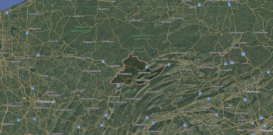
Centre County sits in central Pennsylvania, with State College and Penn State University at its core. It lies about 90 miles northwest of Harrisburg and 140 miles east of Pittsburgh, occupying a broad stretch of the Allegheny Mountains and valleys.
Interstate 80 runs across the northern edge of the county, while U.S. Routes 322 and 220 connect its interior towns and link directly to State College. Its location places it in the geographic center of Pennsylvania, blending mountain ridges, farmland, and a major university hub.
#4. Delaware County, Pennsylvania
– Overall Rank: 136
– Population: 575,312
– Median household income: $86,390
– Median home value: $289,700 (69% own)
– Median rent: $1,257 (31% rent)
– Top public schools: Radnor Senior High School (grade A+), Ithan Elementary School (grade A+), Radnor Middle School (grade A+)
– Top private schools: Jack M. Barrack Hebrew Academy (grade A+), The Episcopal Academy (grade A+), The Agnes Irwin School (grade A+)
– Top places: Swarthmore (grade A+), Rose Valley (grade A+), Nether Providence Township (grade A+)
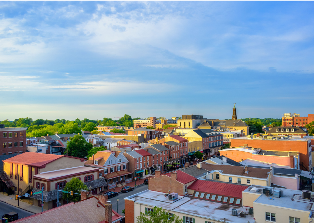
About
Delaware County traces its history to some of Pennsylvania’s earliest settlements, with colonial towns and Revolutionary-era landmarks still shaping its identity. The economy today is driven by healthcare, education, and services, supported by suburban growth tied to the Philadelphia metro region. Media, the county seat, anchors this activity with government, schools, and cultural venues, while towns like Chester, Upper Darby, and Radnor add their own history and character.
Historic districts, local theaters, and parks that connect urban neighborhoods with preserved landscapes are some of county’s pride. Colleges and museums contribute to the county’s cultural strength, while proximity to Philadelphia expands opportunities. With its mix of heritage, strong institutions, and suburban communities, Delaware County blends history with modern vitality.
Where is Delaware County?
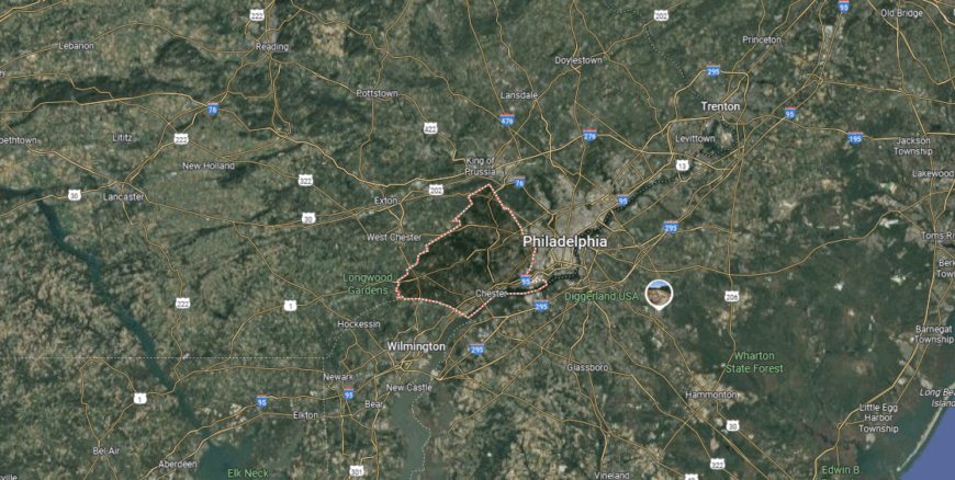
Delaware County is positioned in southeastern Pennsylvania, directly bordering Philadelphia to the southwest. It lies about 15 miles west of downtown Philadelphia and roughly 90 miles northeast of Baltimore, giving it a strong place within the greater Delaware Valley.
Interstate 95 runs along the county’s eastern edge by the Delaware River, while Interstate 476 and U.S. Route 1 provide key north–south and east–west routes across the region. Its location makes it both an extension of Philadelphia’s urban core and a gateway to the state’s suburban and riverfront communities.
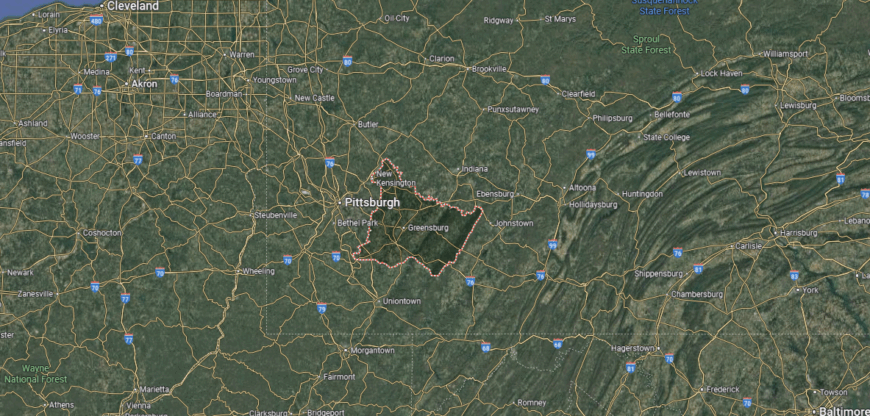
#3. Allegheny County, Pennsylvania
– Overall Rank: 64
– Population: 1,245,310
– Median household income: $72,537
– Median home value: $200,200 (65% own)
– Median rent: $1,050 (35% rent)
– Top public schools: North Allegheny High School (grade A+), Bradford Woods Elementary School (grade A+), Franklin Elementary School (grade A+)
– Top private schools: Shady Side Academy (grade A+), Winchester Thurston School (grade A+), The Ellis School (grade A+)
– Top places: Aspinwall (grade A+), Franklin Park (grade A+), Mount Lebanon Township (grade A+)
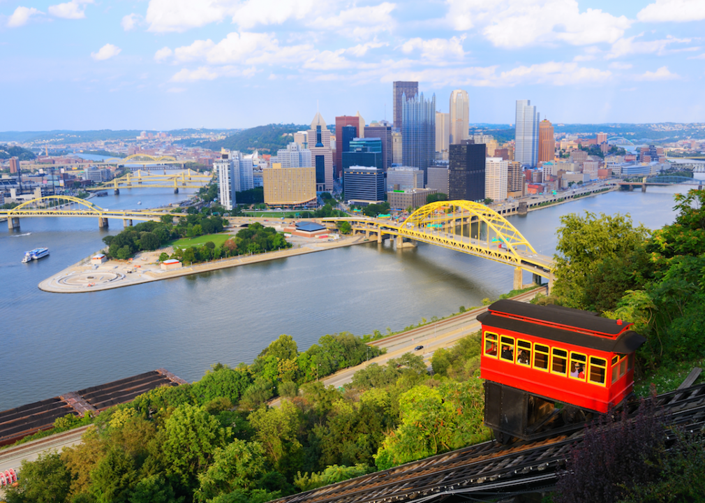
About
Allegheny County is anchored by Pittsburgh, a city that serves as a hub for healthcare, education, technology, and cultural life. The economy has shifted from its steelmaking legacy to a diverse base that includes research, finance, and advanced manufacturing. Suburban communities like Mount Lebanon, Monroeville, and Robinson Township add schools, retail, and neighborhood traditions that strengthen the region.
Pittsburgh offers world-class universities, hospitals, museums, and sports venues that define the county’s identity. Residents enjoy riverfront trails, expansive parks, and cultural festivals that highlight both history and innovation. With its urban energy, strong industries, and surrounding communities, Allegheny County remains one of Pennsylvania’s most dynamic centers.
Where is Allegheny County?
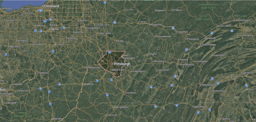
Allegheny County is located in southwestern Pennsylvania, with Pittsburgh as its county seat and largest city. It lies at the junction of the Allegheny, Monongahela, and Ohio Rivers, about 300 miles west of Philadelphia and 130 miles southeast of Cleveland.
Interstate 79 runs north–south through the county, while Interstates 76 (the Pennsylvania Turnpike) and 376 provide key east–west connections. Its location at the meeting point of major rivers and highways makes it a central hub of western Pennsylvania, blending urban density with surrounding hills and valleys.
#2. Chester County, Pennsylvania
– Overall Rank: 51
– Population: 536,474
– Median household income: $118,574
– Median home value: $435,000 (75% own)
– Median rent: $1,601 (25% rent)
– Top public schools: Conestoga Senior High School (grade A+), Downingtown STEM Academy (grade A+), Valley Forge Middle School (grade A+)
– Top private schools: Malvern Preparatory School (grade A+), Westtown School (grade A+), Church Farm School (grade A+)
– Top places: Chesterbrook (grade A+), Devon (grade A+), Paoli (grade A+)
About
Chester County is defined by rolling farmland, woodlands, and the Brandywine Valley, where natural beauty and historic landscapes meet. The economy is supported by agriculture, biotechnology, education, and healthcare, with strong ties to the Philadelphia region. West Chester, the county seat, anchors the area with universities, government services, and cultural venues, while towns like Kennett Square and Phoenixville add their own character.
Residents enjoy preserved parks, equestrian trails, and gardens that highlight the county’s scenic setting. Local festivals, farmers markets, and historic districts connect communities across rural and suburban areas. With its mix of landscapes, industries, and heritage, Chester County balances growth with tradition.
Where is Chester County?
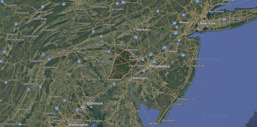
Chester County sits in southeastern Pennsylvania, about 30 miles west of Philadelphia and 20 miles north of Wilmington, Delaware. It lies within the rolling hills of the Piedmont region, where farmland, historic towns, and suburban communities intersect.
U.S. Routes 30 and 202 serve as major corridors through the county, while the Pennsylvania Turnpike (Interstate 76) crosses its northern edge. Its location places it within the greater Philadelphia metropolitan area while still rooted in a landscape of countryside and preserved open space.
#1. Montgomery County, Pennsylvania
– Overall Rank: 32
– Population: 856,399
– Median household income: $107,441
– Median home value: $382,300 (72% own)
– Median rent: $1,514 (28% rent)
– Top public schools: Harriton Senior High School (grade A+), Lower Merion High School (grade A+), The Souderton Charter School Collaborative (grade A+)
– Top private schools: The Baldwin School (grade A+), The Shipley School (grade A+), The Hill School (grade A+)
– Top places: Ardmore (grade A+), Penn Wynne (grade A+), Conshohocken (grade A+)
About
Montgomery County traces its roots to colonial settlements and Revolutionary War sites that remain part of its identity today. The economy is driven by healthcare, education, manufacturing, and a strong service sector, with many residents connected to the wider Philadelphia metro area. Norristown, the county seat, anchors the region with government, schools, and cultural venues, while towns like King of Prussia, Lansdale, and Pottstown contribute their own industries and traditions.
Valley Forge National Historical Park, extensive trail systems, and local festivals that highlight both heritage and community life. Shopping centers, museums, and colleges add vibrancy, while suburban neighborhoods provide stability. With its mix of historic significance, economic strength, and modern amenities, Montgomery County continues to balance tradition with progress.
Where is Montgomery County?
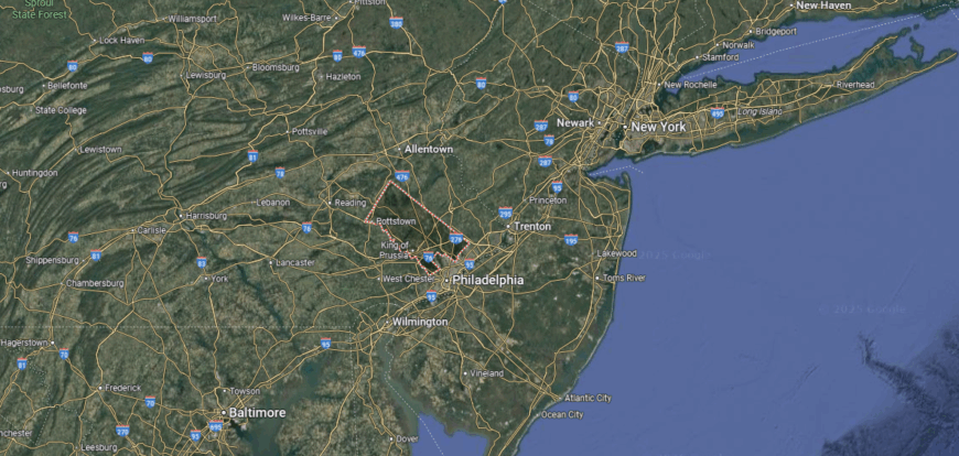
Montgomery County is positioned in southeastern Pennsylvania, directly northwest of Philadelphia. It lies about 25 miles from downtown Philadelphia and 100 miles southwest of New York City, making it part of the greater Delaware Valley region.
The Pennsylvania Turnpike (Interstate 276) runs east–west through the county, while Interstates 76 and 476 provide major connections into Philadelphia and beyond. Its location blends suburban communities, historic towns, and commercial hubs, all within quick reach of the state’s largest city.
This story features data reporting and writing by Elena Cox and is part of a series utilizing data automation across 50 states.
You may also like: How drunk driving fatalities in Pennsylvania compare to the rest of the US
By Stacker