🔥 Would you like to save this?
Best counties to live in Nebraska based on a variety of factors including median home purchase prices
More counties in the United States experienced population growth in the last year, according to the latest Census data, even as pandemic-related moving trends begin to normalize.
Counties in the South continued to experience growth, particularly in Florida, where 96% of its 67 counties gained new residents. Polk County, Florida, a suburb of Orlando, added the most, with 26,000 people moving there in 2023.
Meanwhile, counties in the Midwest and Northeast continued to lose population, but at slower rates than the year before. Some of the biggest losses were in counties home to large cities, including Cook County, Illinois (home of Chicago) and the boroughs of Brooklyn and Queens in New York.
Many counties are experiencing growth due to their job opportunities, education, or relatively affordable housing costs. Others are favored for their historic or well-designed downtowns or access to cultural opportunities.
Stacker compiled a list of the best counties to live in Nebraska using rankings from Niche. Niche ranks counties by various factors including public schools, educational attainment, cost of living, and housing.
Keep reading to see if your county made the list.
You may also like: Nebraska ranks #21 in mental health care deserts
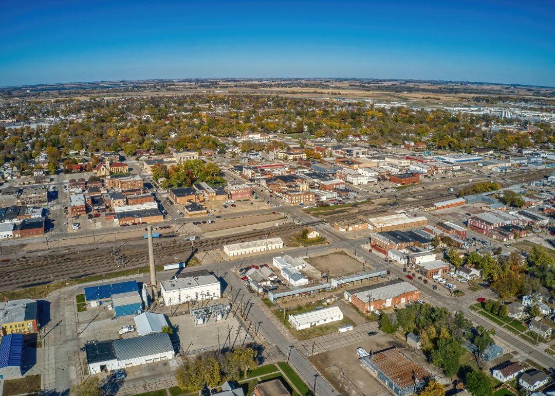
#30. Platte County, Nebraska
– Overall Rank: 987
– Population: 34,219
– Median household income: $69,943
– Median home value: $195,800 (75% own)
– Median rent: $872 (25% rent)
– Top public schools: Lakeview High School (grade B), Lakeview Junior High School (grade B), Columbus High School (grade B minus)
– Top private schools: Scotus Central Catholic High School (grade B), Lindsay Holy Family School (grade B minus), St. Francis Schools (grade C+)
– Top places: Columbus (grade B), Walker Township (grade A minus), Monroe Township (grade B+)
About
Platte County, Nebraska rests along the Platte River in the eastern part of the state, where fertile soil and waterways have long supported farming and settlement. Columbus, the county seat, serves as a regional hub with historic districts, cultural venues, and strong civic traditions that anchor the community. The landscape combines agricultural fields with open plains, creating both economic strength and scenic identity.
Agriculture remains central to the economy, with corn, soybeans, and livestock production forming its backbone. Manufacturing, energy, and service industries have expanded in recent decades, adding diversity and stability to the local workforce. Platte County reflects a balance of rich farmland, economic resilience, and a tradition of community rooted in both land and history.
Where is Platte County?
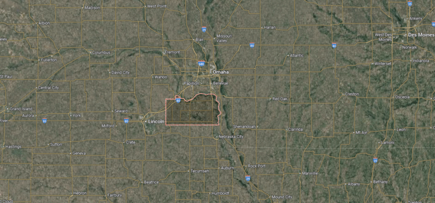
Platte County is located in eastern Nebraska, bordered by Madison County to the north and Butler County to the south. It lies about 85 miles west of Omaha and roughly 60 miles northwest of Lincoln, placing it within reach of the state’s largest metropolitan areas. The Loup and Platte Rivers run through the county, shaping both its geography and agricultural base.
Columbus serves as the county seat and is positioned near the confluence of the Loup and Platte Rivers. Smaller communities such as Humphrey, Duncan, and Monroe add to the county’s rural and small-town character. With U.S. Highways 30 and 81 crossing the area, Platte County serves as a key transportation link in eastern Nebraska.
#29. Clay County, Nebraska
– Overall Rank: 963
– Population: 6,088
– Median household income: $73,933
– Median home value: $129,600 (80% own)
– Median rent: $668 (20% rent)
– Top public schools: Sandy Creek Middle School (grade B+), Sutton Secondary School (grade B), Sutton Elementary School (grade B)
– Top private schools:
– Top places: Leicester Township (grade B+), Sutton (grade B+), Clay Center (grade B+)
About
Clay County, Nebraska developed as a farming stronghold in the late 19th century, with its towns and villages reflecting that agricultural heritage. Courthouses, grain elevators, and historic main streets stand as reminders of the role the county has played in supporting Nebraska’s rural economy. Cultural life centers on fairs, local festivals, and schools that bring residents together year after year.
Today, agriculture still anchors the economy, with row crops and livestock dominating production. At the same time, small businesses, light manufacturing, and local services provide added stability. Clay County illustrates how a rural region can preserve its history while adapting to modern economic needs.
Where is Clay County?
Clay County is situated in south-central Nebraska, bordered by Hamilton County to the north and Nuckolls County to the south. It lies about 25 miles south of Grand Island and roughly 100 miles southwest of Lincoln. The county’s landscape is defined by flat to gently rolling plains, farmland, and prairie typical of the region.
Clay Center serves as the county seat and sits near the geographic middle of the county. Other towns such as Sutton, Harvard, and Fairfield contribute to its agricultural economy and community life. State highways connect the area to larger cities, making it an accessible yet rural part of Nebraska.
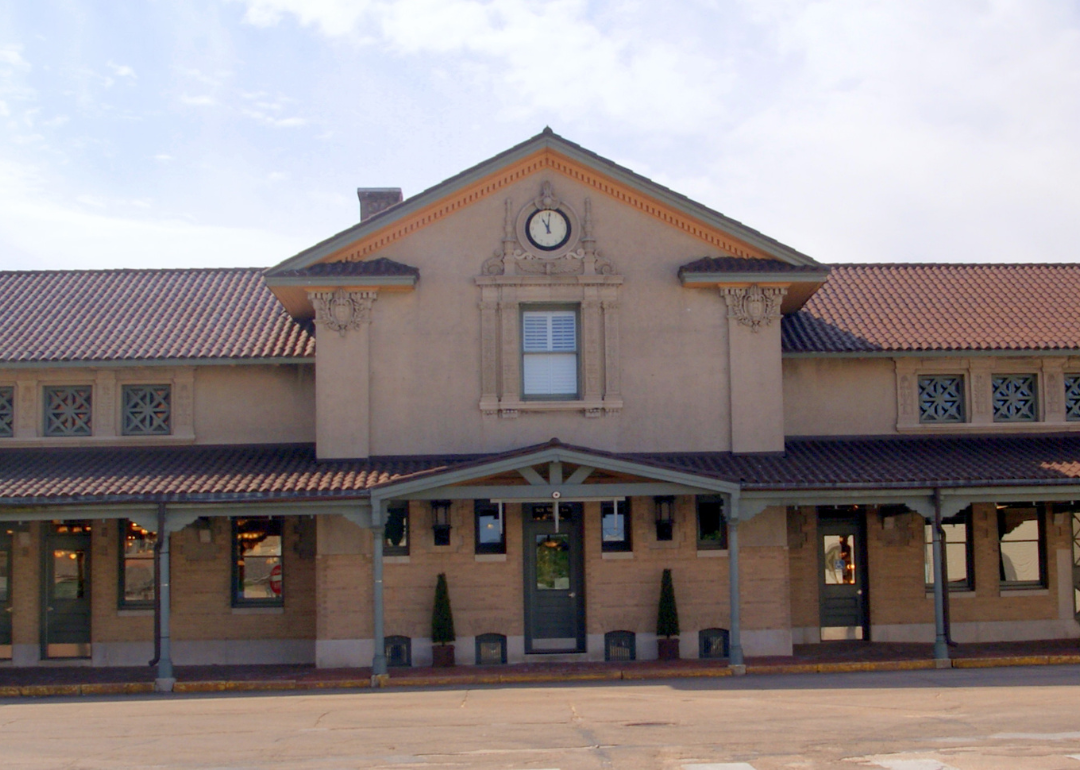
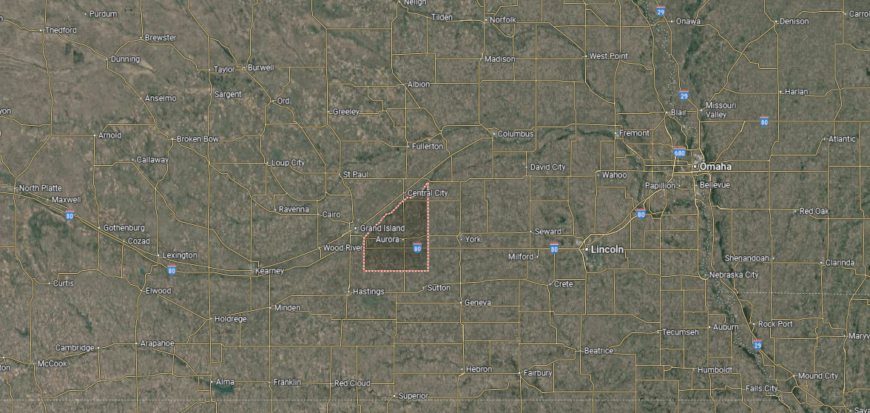
#28. Hall County, Nebraska
– Overall Rank: 938
– Population: 62,575
– Median household income: $63,553
– Median home value: $190,800 (62% own)
– Median rent: $886 (38% rent)
– Top public schools: Wood River Rural High School (grade A minus), Westridge Middle School (grade B+), Cedar Hollow School (grade B)
– Top private schools: Grand Island Central Catholic School (grade A minus), Heartland Lutheran High School (grade B), Trinity Lutheran School (grade unavailable)
– Top places: Grand Island (grade B minus), Center Township (grade A), Wood River Township (grade B+)
About
Hall County, Nebraska is anchored by Grand Island, one of the state’s major regional centers and a hub of culture, transportation, and commerce. The county’s history is tied to the Platte River and the arrival of the railroad, which shaped its growth and settlement patterns. Landmarks, museums, and annual events like the Nebraska State Fair highlight its civic and cultural presence.
The economy is broad and diverse, with agriculture supported by irrigation from the Platte River alongside strong manufacturing, healthcare, and retail sectors. Transportation and logistics also play a key role, reflecting the county’s central location in Nebraska. Hall County stands out as a place where history, economic vitality, and cultural life converge.
Where is Hall County?
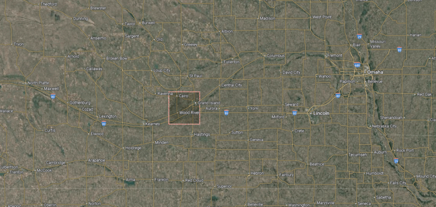
Hall County is located in south-central Nebraska, bordered by Merrick County to the north and Adams County to the south. It lies about 95 miles west of Lincoln and roughly 150 miles west of Omaha. The Platte River flows across the southern part of the county, shaping both its landscape and agricultural productivity.
Grand Island serves as the county seat and is also the largest city, positioned near the center along Interstate 80. Smaller communities such as Wood River, Alda, and Cairo contribute to the county’s mix of urban and rural life. With its central location and major transportation routes, the county is an important hub for trade and travel in Nebraska.
#27. Custer County, Nebraska
– Overall Rank: 937
– Population: 10,566
– Median household income: $62,288
– Median home value: $133,400 (70% own)
– Median rent: $765 (30% rent)
– Top public schools: Arnold Elementary School (grade B+), North Park Elementary School (grade B), Sargent Elementary School (grade B)
– Top private schools:
– Top places: Broken Bow (grade B+), Arnold Township (grade B+)
About
Custer County, Nebraska stretches across the central Sandhills, making it the largest county in the state by land area. Broken Bow, the county seat, serves as a center of culture and commerce, surrounded by open rangeland, rolling hills, and expansive skies that define the county’s identity. Its history reflects the settlement era, with preserved landmarks and traditions still woven into community life.
Ranching and farming dominate the economy, with cattle production and crop agriculture forming the backbone of local livelihoods. Small industries, retail, and tourism linked to the Sandhills provide additional support and diversity. Custer County embodies the spirit of the Great Plains—vast, resilient, and deeply tied to the land.
Where is Custer County?
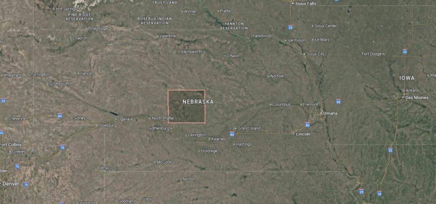
Custer County is found in central Nebraska, bordered by Valley County to the north and Dawson County to the south. It is one of the state’s largest counties by area, covering expansive prairies, river valleys, and rolling hills. The Middle Loup River flows through the region, supporting both agriculture and recreation.
Broken Bow serves as the county seat and is positioned near the center of the county. Smaller towns such as Arnold, Callaway, and Ansley add to the county’s rural character and community life. With state highways linking it to neighboring regions, the area balances wide open landscapes with accessible connections.
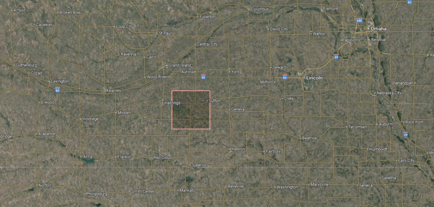
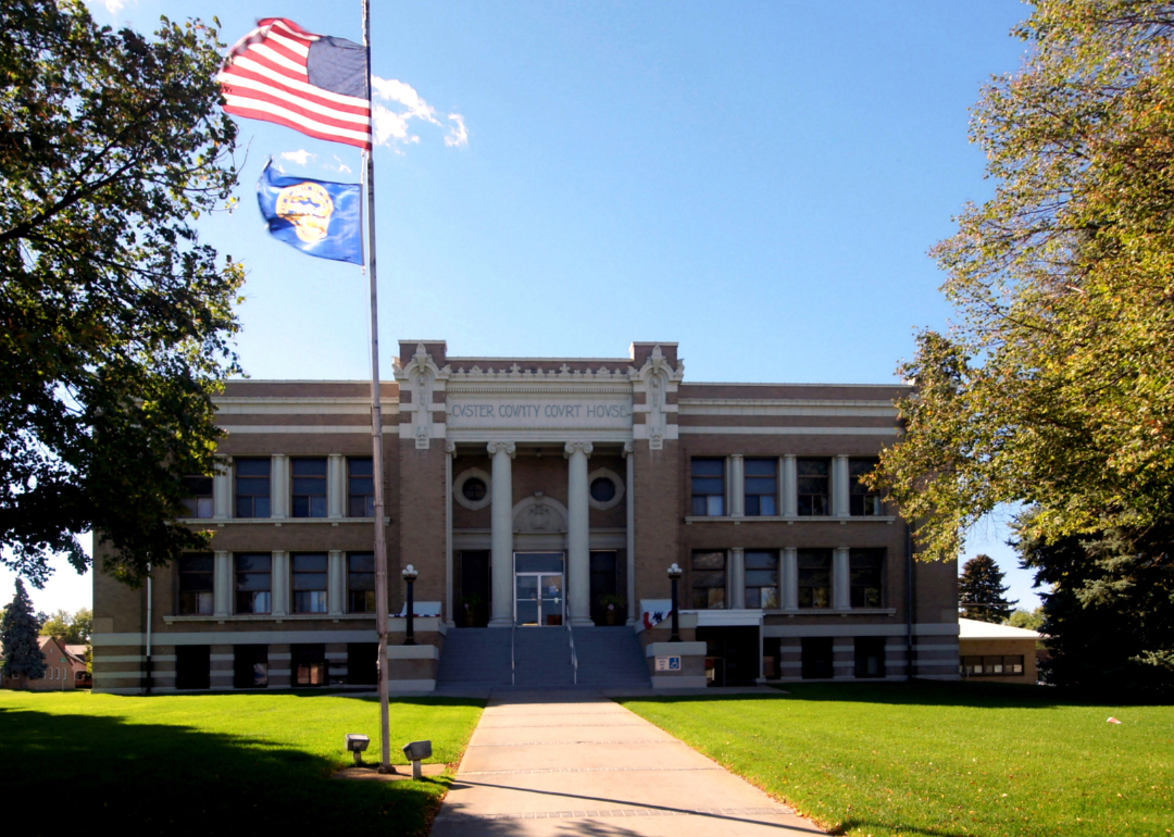
#26. Adams County, Nebraska
– Overall Rank: 914
– Population: 31,143
– Median household income: $61,502
– Median home value: $166,300 (68% own)
– Median rent: $812 (32% rent)
– Top public schools: Adams Central Elementary School (grade B+), Adams Central Junior/Senior High School (grade B+), Kenesaw High School (grade B)
– Top private schools: St. Cecilia High School (grade B), St. Michael’s School (grade unavailable), Christ Lutheran School (grade unavailable)
– Top places: Hastings (grade B), West Blue Township (grade A minus), Denver Township (grade A minus)
You may also like: How drunk driving fatalities in Nebraska compare to the rest of the US
About
Adams County, Nebraska grew around Hastings, its county seat, which developed into a regional hub of culture, commerce, and education. The county’s history includes the World War II Naval Ammunition Depot, once one of the largest of its kind, leaving a lasting mark on both the landscape and community identity. Local traditions and historic neighborhoods continue to shape the sense of place.
Agriculture remains a vital part of the economy, with corn, soybeans, and livestock production supporting regional markets. Manufacturing, education, healthcare, and retail add strength and balance, making Hastings a center of economic activity in south-central Nebraska. Adams County reflects a blend of historic depth, agricultural heritage, and modern industry.
Where is Adams County?
Adams County is located in south-central Nebraska, bordered by Hall County to the north and Webster County to the south. It lies about 100 miles west of Lincoln and roughly 160 miles west of Omaha. The county’s landscape is characterized by flat to gently rolling plains, farmland, and sections of the Little Blue River valley.
Hastings serves as the county seat and is the largest city, positioned near the center along U.S. Highways 6 and 281. Other communities such as Juniata, Kenesaw, and Roseland contribute to the county’s rural and suburban mix. With its strong agricultural base and highway access, the county plays a central role in Nebraska’s heartland region.
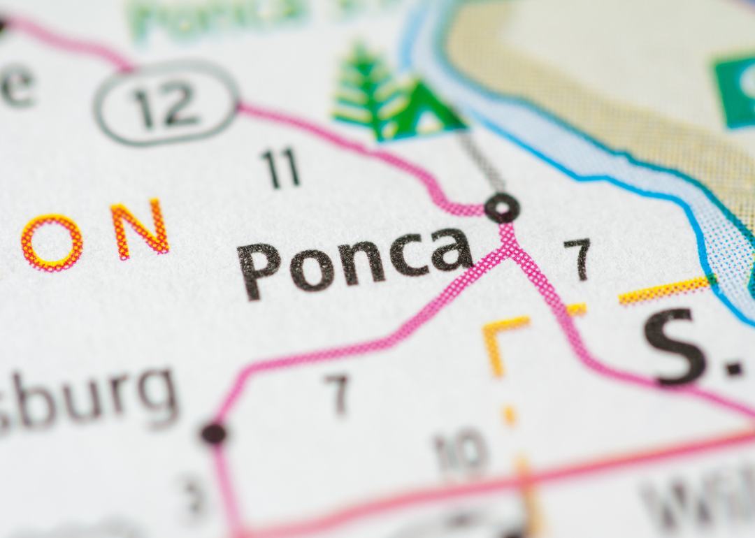
#25. Dixon County, Nebraska
– Overall Rank: 819
– Population: 5,579
– Median household income: $60,568
– Median home value: $123,500 (75% own)
– Median rent: $676 (25% rent)
– Top public schools: Emerson-Hubbard Elementary School (grade A minus), Ponca Elementary School (grade B+), Ponca High School (grade B)
– Top private schools:
– Top places: Ponca (grade A minus), Newcastle Township (grade A minus), Newcastle (grade B+)
🔥 Would you like to save this?
About
Dixon County, Nebraska rests in the northeastern corner of the state, bordered by the Missouri River and marked by rolling hills and fertile farmland. Its small towns, including Ponca, the county seat, carry a strong sense of heritage with historic buildings, local festivals, and ties to early settlement. The nearby Ponca State Park adds natural beauty, offering recreation and a connection to the river landscape.
Agriculture anchors the economy, with corn, soybeans, and livestock production shaping daily life and regional trade. Small businesses and local services sustain community needs, while tourism tied to the park and river brings added activity. Dixon County reflects a steady balance of natural resources, agricultural strength, and preserved history.
Where is Dixon County?
Dixon County is situated in northeastern Nebraska, bordered by Dakota County to the east and Cedar County to the west. It lies along the Missouri River, which forms its northern boundary with South Dakota. The terrain features river bluffs, rolling hills, and fertile farmland.
Ponca serves as the county seat and is located near the Missouri River. Other towns such as Wakefield, Allen, and Martinsburg contribute to the county’s rural community network. With scenic river access and state highways crossing the area, Dixon County connects agricultural life with natural resources.
#24. Saunders County, Nebraska
– Overall Rank: 805
– Population: 22,374
– Median household income: $84,474
– Median home value: $220,600 (81% own)
– Median rent: $892 (19% rent)
– Top public schools: Wahoo Middle School (grade B+), Ashland-Greenwood Elementary School (grade B+), Ashland-Greenwood High School (grade B+)
– Top private schools: Bishop Neumann Jr/Sr Catholic High School (grade B minus), St. Wenceslaus School (grade unavailable), St. John Nepomucene School (grade unavailable)
– Top places: Wahoo (grade A minus), Ashland (grade B+), Ashland Township (grade A minus)
About
Saunders County, Nebraska sits between the Platte and Elkhorn Rivers, giving it rich farmland and a landscape shaped by water and open plains. Wahoo, the county seat, blends historic architecture with a role as a civic and cultural hub for the surrounding towns and villages. Local heritage is reflected in preserved landmarks, rural traditions, and long-standing community ties.
The economy relies heavily on agriculture, with corn, soybeans, and livestock forming its base, while agribusiness and related industries provide added support. Small manufacturers, services, and retail outlets contribute to growth, benefiting from the county’s location near both Lincoln and Omaha. Saunders County stands as a place where fertile land, regional connections, and a blend of tradition and development define its identity.
Where is Saunders County?
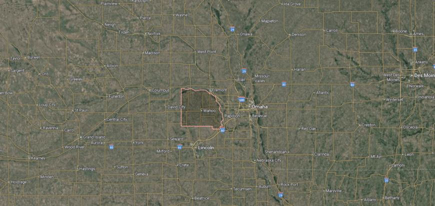
Saunders County is located in eastern Nebraska, bordered by Dodge County to the north and Lancaster County to the south. It lies just west of Omaha and north of Lincoln, placing it between the state’s two largest metropolitan areas. The Platte River forms much of its northern and eastern boundary, shaping both its geography and farmland.
Wahoo serves as the county seat and sits near the geographic center of the county. Smaller towns such as Ashland, Ceresco, and Yutan add to the local community network. With close access to major highways and nearby cities, Saunders County combines rural character with strong regional connections.
#23. Cass County, Nebraska
– Overall Rank: 768
– Population: 26,749
– Median household income: $87,673
– Median home value: $234,300 (83% own)
– Median rent: $970 (17% rent)
– Top public schools: Elmwood-Murdock Elementary School (grade A minus), Elmwood-Murdock Junior/Senior High School (grade A minus), Conestoga Elementary School (grade B)
– Top private schools: First Baptist School (grade B minus), St. John the Baptist School (grade unavailable)
– Top places: Plattsmouth (grade B minus), Louisville (grade A minus), Elmwood (grade A minus)
About
Cass County, Nebraska lies along the Missouri River in the southeastern part of the state, where bluffs, valleys, and fertile farmland give it a distinctive landscape. Plattsmouth, the county seat, carries historic character with its old riverfront ties and preserved architecture. The county is also known for its scenic parks and recreation areas, including access to lakes and trails that highlight its natural beauty.
Agriculture forms a strong base of the economy, centered on corn, soybeans, and livestock production. Proximity to Omaha and Lincoln has also encouraged commuting, small business growth, and light industry, adding balance to the traditional rural economy. Cass County represents a blend of historic roots, agricultural strength, and modern connections to Nebraska’s urban centers.
Where is Cass County?
Cass County is positioned in southeastern Nebraska, bordered by Sarpy County to the north and Otoe County to the south. It lies along the Missouri River, which forms its eastern boundary with Iowa. The landscape consists of river valleys, rolling hills, and fertile farmland.
Plattsmouth serves as the county seat and is located on the Missouri River near the northern end of the county. Other communities such as Louisville, Weeping Water, and Elmwood add to its small-town network. With Interstate 80 and U.S. Highway 75 running nearby, the county is closely tied to both Omaha and Lincoln.
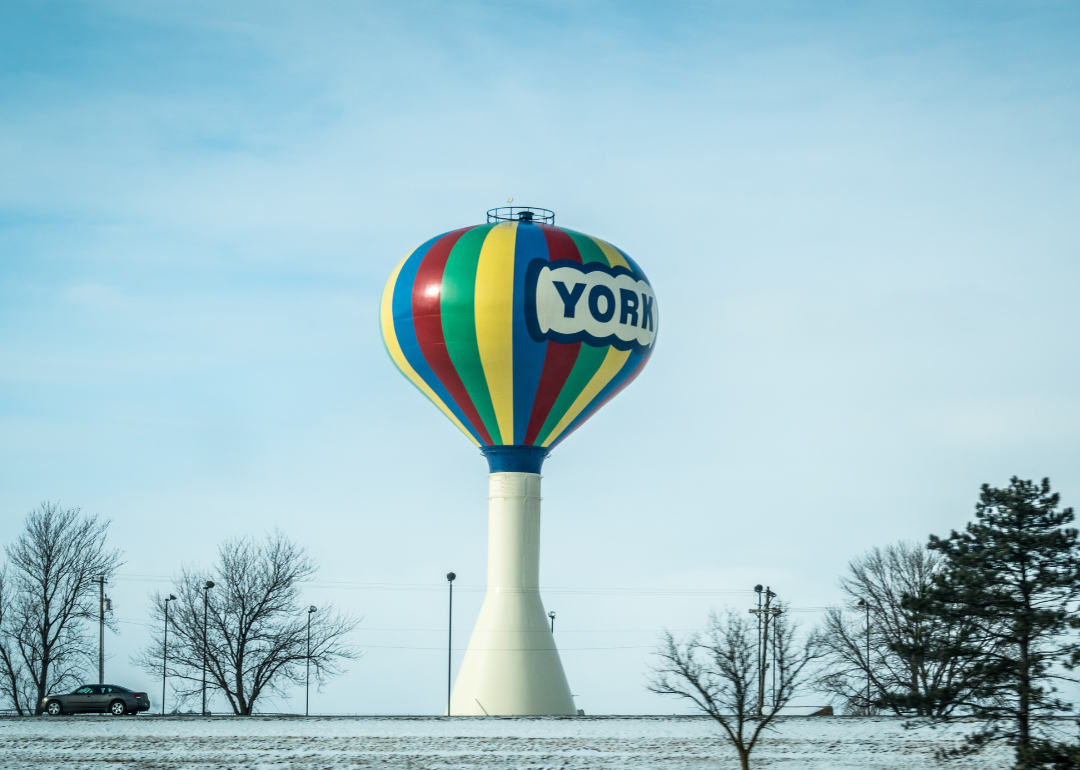
#22. York County, Nebraska
– Overall Rank: 740
– Population: 14,212
– Median household income: $72,914
– Median home value: $160,500 (75% own)
– Median rent: $842 (25% rent)
– Top public schools: Heartland Community High School (grade B+), Heartland Community Elementary School (grade B+), York Middle School (grade B+)
– Top private schools: Nebraska Evangelical Lutheran High School (grade A), Emmanuel-Faith Lutheran School (grade unavailable), St. Joseph Catholic School (grade unavailable)
– Top places: York (grade B+), Bradshaw (grade A minus), Henderson (grade B+)
About
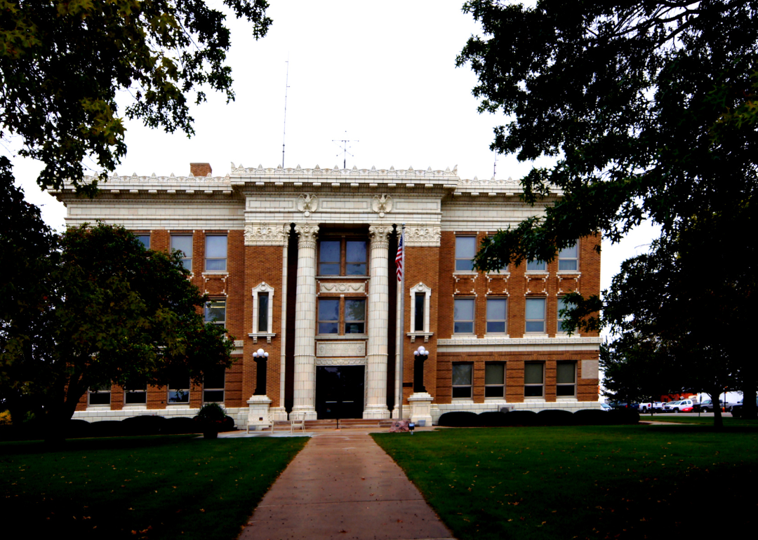
York County, Nebraska sits in south-central Nebraska, where gently rolling farmland and open skies define the landscape. York, the county seat, serves as a regional crossroads with historic landmarks, schools, and cultural institutions that anchor civic life. Its location along Interstate 80 has long made it a gateway for travelers and commerce across the state.
Agriculture drives the economy, with corn, soybeans, and livestock production at the forefront, supported by agribusiness and related industries. Manufacturing, retail, and services add further strength, while transportation links continue to support growth and opportunity. York County reflects a balance of strong rural heritage, economic adaptability, and regional importance.
Where is York County?
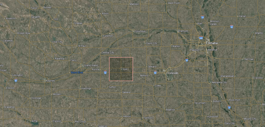
York County is located in south-central Nebraska, bordered by Seward County to the east and Hamilton County to the west. It sits about 50 miles west of Lincoln and roughly 120 miles southwest of Omaha. The county’s geography is defined by flat to gently rolling farmland, dotted with small creeks and rural roads that form part of the region’s agricultural grid.
York, the county seat, lies along Interstate 80 and serves as a convenient hub for both travelers and commerce. Smaller towns such as Waco, McCool Junction, and Benedict contribute to the county’s rural network, supporting the farming economy and community life. With its central placement on major transportation routes, York County connects Nebraska’s agricultural heartland to larger state and regional markets.
#21. Scotts Bluff County, Nebraska
– Overall Rank: 734
– Population: 36,048
– Median household income: $60,137
– Median home value: $150,600 (68% own)
– Median rent: $876 (32% rent)
– Top public schools: Mitchell Secondary School (grade B+), Mitchell Elementary School (grade B), Geil Elementary School (grade B)
– Top private schools: St. Agnes Catholic School (grade unavailable), Community Christian Elementary/Middle School (grade unavailable), Helping Hands Preschool (grade unavailable)
– Top places: Gering (grade B+), Scottsbluff (grade B), Mitchell (grade B+)
You may also like: Risky reservoirs: Nebraska counties where aging dams pose the greatest threat
About
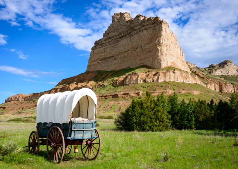
Scotts Bluff County, Nebraska is defined by its striking landscapes, with the monumental Scotts Bluff National Monument rising above the North Platte River valley. The county seat, Gering, along with neighboring Scottsbluff, forms a cultural and economic center for the Panhandle region. Historic trails that once guided westward migration add a deep sense of heritage to the area.
Agriculture, particularly sugar beet farming, cattle, and corn production, anchors the economy and has long shaped the county’s identity. Food processing, healthcare, education, and retail provide added stability, making Scotts Bluff a hub for surrounding rural communities. The county blends dramatic natural landmarks, rich history, and a diverse economy into a defining presence in western Nebraska.
Where is Scotts Bluff County?
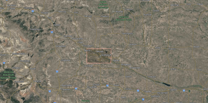
Scotts Bluff County is located in the western Panhandle of Nebraska, bordered by Sioux County to the north and Banner County to the south. It lies along the North Platte River, about 20 miles from the Wyoming state line and nearly 45 miles north of Colorado. The county’s terrain includes river valleys, high plains, and the prominent bluff formations that give the area its name.
Gering serves as the county seat, while the neighboring city of Scottsbluff is the largest community and commercial hub. Other towns such as Mitchell, Morrill, and Minatare contribute to the county’s mix of small-town and rural life. With U.S. Highways 26 and 71 and the Scotts Bluff National Monument nearby, the county is both a transportation center and a site of historical and natural significance.
#20. Polk County, Nebraska
– Overall Rank: 727
– Population: 5,182
– Median household income: $67,695
– Median home value: $152,700 (81% own)
– Median rent: $636 (19% rent)
– Top public schools: Cross County Elementary School (grade A minus), Osceola Elementary School (grade A minus), Cross County Middle School (grade B+)
– Top private schools:
– Top places: Stromsburg (grade A minus), Osceola (grade B+), Shelby (grade B)
About
Polk County, Nebraska rests in the central part of the state, where broad prairies and fertile soil have long supported farming communities. Osceola, the county seat, reflects small-town traditions with historic landmarks, schools, and civic institutions that anchor local life. The county’s landscape, shaped by open fields and quiet waterways, highlights its strong agricultural character.
Corn, soybeans, and livestock production form the backbone of the economy, with agribusiness and related services supporting local growth. Small industries, retail, and community-based enterprises provide added opportunities while maintaining a rural identity. Polk County represents the enduring strength of Nebraska’s farmland, blending economic resilience with deep-rooted tradition.
Where is Polk County?
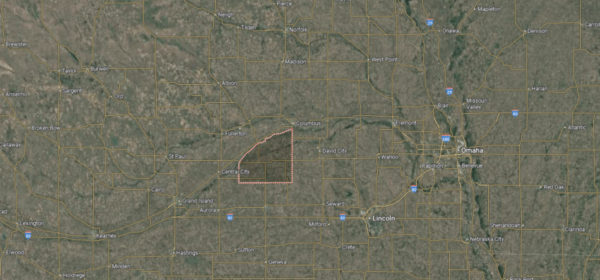
Polk County is situated in east-central Nebraska, bordered by Merrick County to the north and York County to the south. It lies about 75 miles west of Omaha and roughly 60 miles northwest of Lincoln. The county’s landscape is made up of fertile farmland, open prairies, and small creeks that support its strong agricultural base.
Osceola serves as the county seat and is located near the center of the county. Other communities such as Stromsburg, Shelby, and Polk add to its network of small towns. With state highways connecting it to larger cities, the county maintains both its rural character and accessibility to regional markets.
#19. Otoe County, Nebraska
– Overall Rank: 710
– Population: 15,995
– Median household income: $73,031
– Median home value: $172,500 (77% own)
– Median rent: $881 (23% rent)
– Top public schools: Middle School at Syracuse (grade A minus), High School at Syracuse (grade B+), Elementary School at Syracuse (grade B+)
– Top private schools: Lourdes Central Catholic School (grade B+)
– Top places: Nebraska City (grade B+), Syracuse (grade A minus), Unadilla (grade B+)
🔥 Would you like to save this?
About
Otoe County, Nebraska is set along the Missouri River in the southeastern part of the state, where fertile valleys and wooded bluffs define its landscape. Nebraska City, the county seat, is notable as the home of Arbor Day and carries a strong legacy of conservation and civic pride. Historic districts, museums, and cultural landmarks highlight the county’s long role in Nebraska’s development.
Agriculture remains a cornerstone of the economy, with corn, soybeans, and orchards shaping both production and identity. Proximity to the river has also supported trade, industry, and tourism, giving balance to the traditional rural base. Otoe County blends historic significance, natural beauty, and a resilient economy into a lasting regional presence.
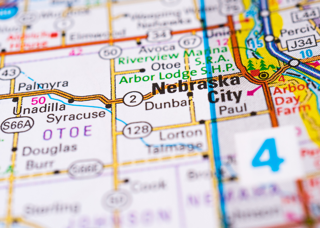
Where is Otoe County?
Otoe County is located in southeastern Nebraska, bordered by Cass County to the north and Johnson County to the south. It lies along the Missouri River, which forms its eastern boundary with the state of Iowa. The terrain consists of fertile river bottomlands, rolling hills, and stretches of farmland.
Nebraska City serves as the county seat and is a historic community positioned on the river. Other towns such as Syracuse, Palmyra, and Talmage contribute to the county’s agricultural and small-town character. With U.S. Highways 2 and 75 passing through, the area connects easily to Lincoln, Omaha, and surrounding states.
#18. Cuming County, Nebraska
– Overall Rank: 705
– Population: 9,000
– Median household income: $68,917
– Median home value: $160,000 (71% own)
– Median rent: $782 (29% rent)
– Top public schools: West Point Elementary School (grade A minus), Wisner-Pilger Elementary School (grade B+), Bancroft-Rosalie Junior/Senior High School (grade B)
– Top private schools: Guardian Angels Central Catholic High School (grade B+), Guardian Angels Elementary School (grade unavailable), St. Paul Lutheran School (grade unavailable)
– Top places: West Point (grade B+), Beemer Township (grade B+)
About
Cuming County, Nebraska is located in the northeastern part of the state, where fertile farmland and small towns form the backbone of daily life. West Point, the county seat, serves as a center of culture and tradition, with historic churches, schools, and civic institutions shaping its identity. The county’s history is rooted in early German and Czech settlers, whose influence is still visible in festivals and community life.
Agriculture dominates the economy, with corn, soybeans, and livestock production providing stability and regional importance. Agribusiness and related services strengthen local growth, while small industries and retail support residents’ needs. Cuming County reflects a blend of immigrant heritage, agricultural strength, and enduring rural tradition.
Where is Cuming County?
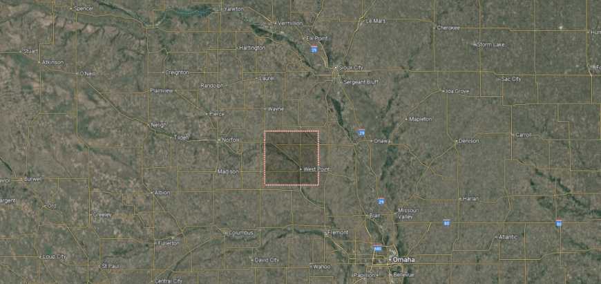
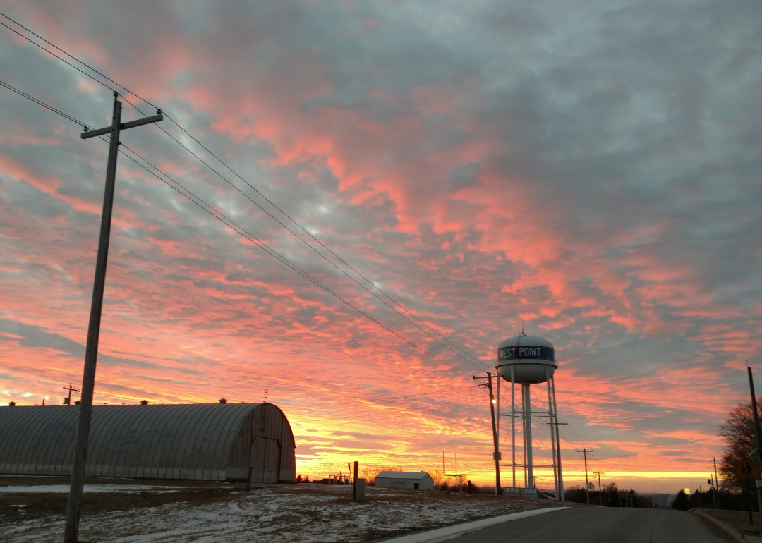
Cuming County is situated in northeastern Nebraska, bordered by Burt County to the east and Stanton County to the west. It lies about 80 miles northwest of Omaha and roughly 95 miles north of Lincoln. The county’s landscape is dominated by rolling farmland, river valleys, and prairie typical of the region.
West Point serves as the county seat and is positioned along the Elkhorn River. Smaller communities such as Beemer, Bancroft, and Wisner contribute to the county’s agricultural economy and small-town life. With state highways running through the area, Cuming County maintains close ties to both nearby rural counties and larger cities in eastern Nebraska.
#17. Thayer County, Nebraska
– Overall Rank: 701
– Population: 5,006
– Median household income: $60,305
– Median home value: $91,600 (77% own)
– Median rent: $719 (23% rent)
– Top public schools: Thayer Central Intermediate School (grade A minus), Bruning-Davenport Middle School (grade B+), Thayer Central High School (grade B)
– Top private schools: Deshler Lutheran School (grade unavailable)
– Top places: Bruning (grade A minus), Davenport (grade B+), Hebron (grade B)
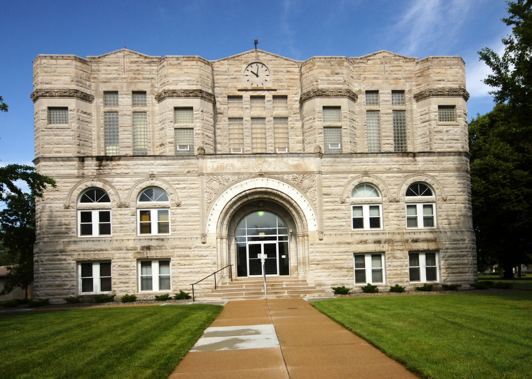
About
Thayer County, Nebraska sits along the Kansas border in the south-central part of the state, where open prairies and farmland define the landscape. Hebron, the county seat, is known for its historic courthouse, small-town traditions, and the world’s largest covered porch swing, a local landmark that reflects its unique character. The county’s heritage is tied to early settlers who built lasting communities around the land.
Agriculture is the foundation of the economy, with corn, soybeans, and livestock production shaping daily life and trade. Small businesses and local services add stability, while regional connections help support growth. Thayer County represents the enduring strength of rural Nebraska, combining history, farming traditions, and community pride.
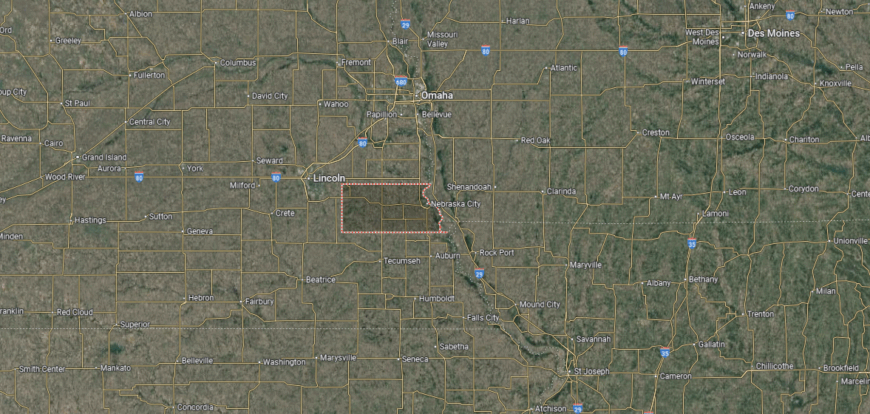
Where is Thayer County?
Thayer County is located in southern Nebraska along the Kansas state line, bordered by Jefferson County to the east and Nuckolls County to the west. It lies about 65 miles southwest of Lincoln and nearly 150 miles southwest of Omaha. The county’s terrain features broad plains, fertile farmland, and small creeks that support its agricultural base.
Hebron serves as the county seat and is positioned near the center of the county along U.S. Highway 136. Smaller communities such as Deshler, Davenport, and Bruning add to the county’s rural network. With its location on the state border, Thayer County connects Nebraska’s heartland with northern Kansas.
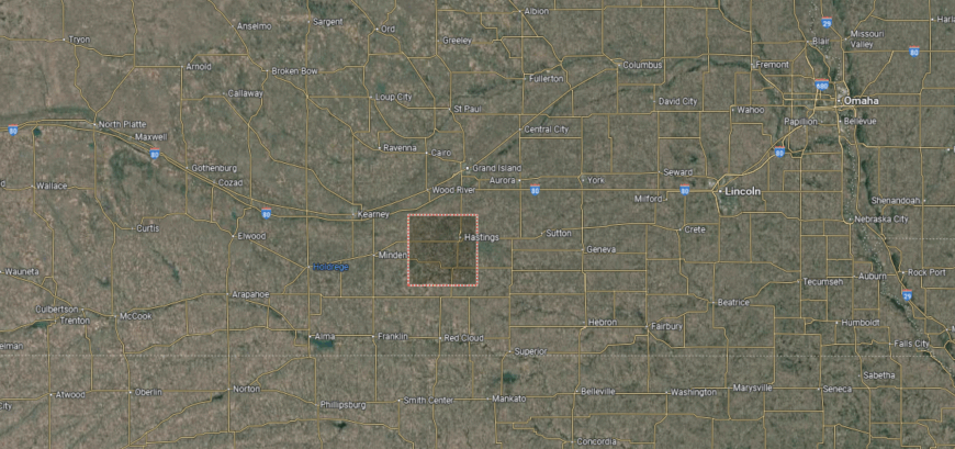
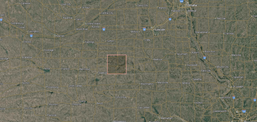
#16. Kearney County, Nebraska
– Overall Rank: 695
– Population: 6,655
– Median household income: $74,276
– Median home value: $203,200 (77% own)
– Median rent: $784 (23% rent)
– Top public schools: Minden East Elementary School (grade B+), C.L. Jones Middle School (grade B), Minden High School (grade B)
– Top private schools:
– Top places: Minden (grade B+), Lincoln Township (grade B+), Blaine Township (grade B+)
You may also like: Counties with the most bridges in Nebraska
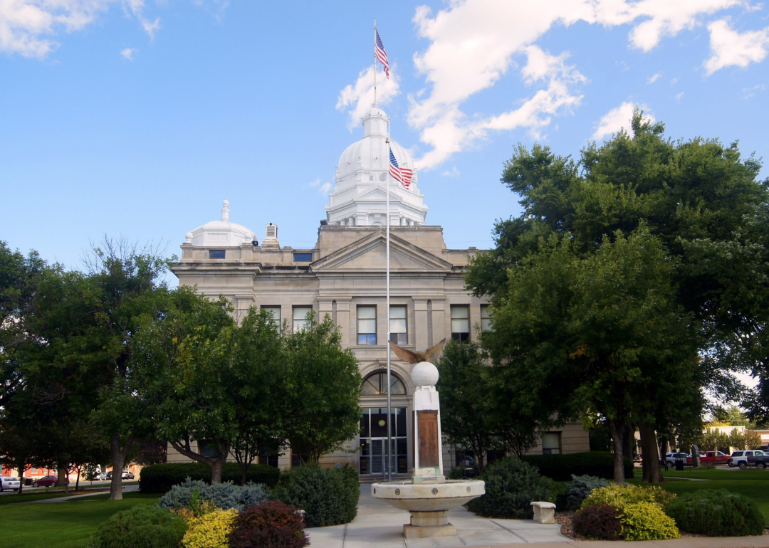
About
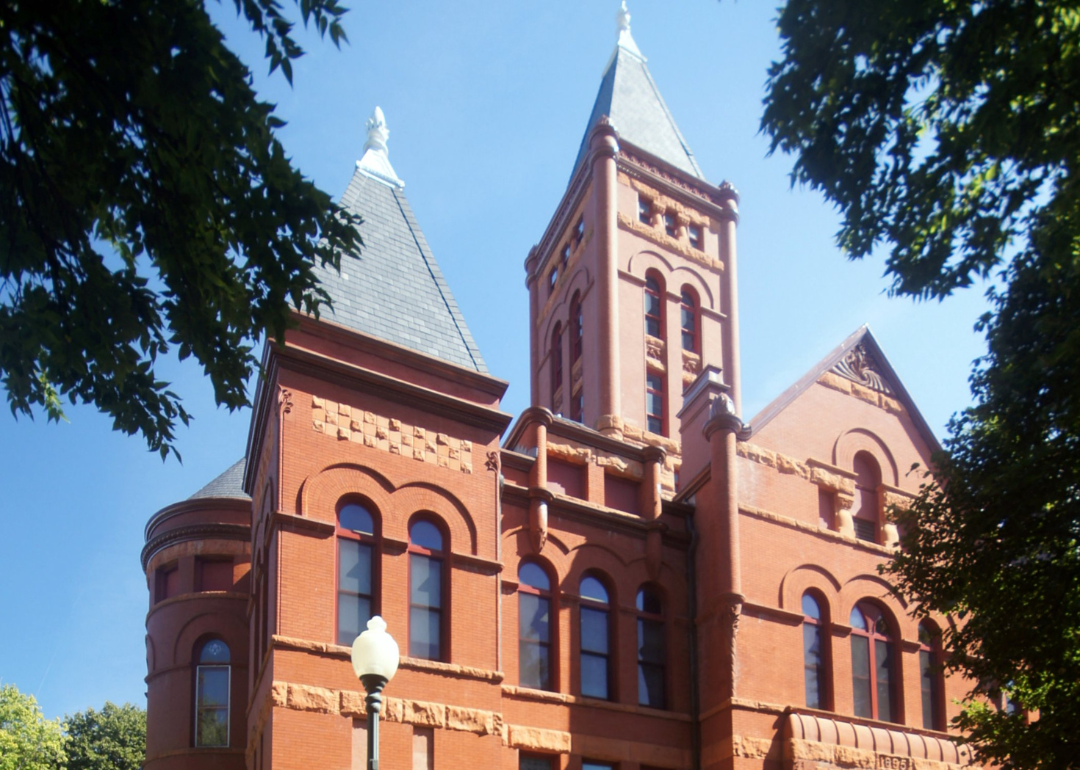
Kearney County, Nebraska lies in the south-central part of the state, with Minden serving as its county seat. Known for the Harold Warp Pioneer Village, Minden highlights the county’s deep ties to history and its role in preserving the story of settlement and progress on the Plains. The county’s landscape of fertile farmland and open skies reflects the agricultural backbone that has long defined the area.
The economy centers on farming, with corn, soybeans, and livestock production shaping both local livelihoods and regional markets. Agribusiness, small industries, and community enterprises provide additional strength, ensuring balance beyond traditional agriculture. Kearney County blends historic preservation, strong rural values, and steady economic resilience.
Where is Kearney County?
Kearney County is located in south-central Nebraska, bordered by Buffalo County to the north and Franklin County to the south. It sits about 15 miles south of the city of Kearney and roughly 125 miles west of Lincoln. The county’s landscape is made up of fertile plains, farmland, and portions of the Platte River valley.
Minden serves as the county seat and is positioned near the center of the county. Smaller towns such as Axtell, Norman, and Wilcox contribute to the agricultural economy and community life. With U.S. Highway 6 and state routes crossing the area, the county maintains strong connections to neighboring regions.
#15. Hamilton County, Nebraska
– Overall Rank: 686
– Population: 9,400
– Median household income: $73,254
– Median home value: $201,200 (81% own)
– Median rent: $822 (19% rent)
– Top public schools: Aurora Elementary School (grade A minus), Aurora Middle School (grade B+), Aurora High School (grade B+)
– Top private schools: Hampton Lutheran School (grade unavailable), Immanuel Lutheran School (grade unavailable)
– Top places: Aurora (grade B+), Overland (grade B), Giltner (grade B)
About
Hamilton County, Nebraska rests in the heart of the state, with Aurora as its county seat and cultural center. The Plains landscape, marked by fertile fields and open skies, has long supported farming communities and shaped the county’s rural identity. Aurora also carries historic charm, with landmarks, museums, and civic traditions that highlight the area’s heritage.
Agriculture anchors the economy through corn, soybeans, and livestock, while agribusiness and food processing strengthen its regional role. Renewable energy, small industries, and local services add further stability to the workforce. Hamilton County reflects a balance of historic depth, agricultural strength, and modern adaptability.
Where is Hamilton County?
🔥 Would you like to save this?
Hamilton County is situated in south-central Nebraska, bordered by Merrick County to the north and Clay County to the south. It lies about 25 miles northeast of Grand Island and roughly 65 miles west of Lincoln. The county’s landscape features open farmland, prairie, and small creeks that flow into the Platte River.
Aurora serves as the county seat and is positioned near the geographic center of the county. Other communities such as Giltner, Hampton, and Marquette add to the county’s rural network. With Interstate 80 and U.S. Highway 34 running through the area, Hamilton County is well connected to regional trade and travel routes.
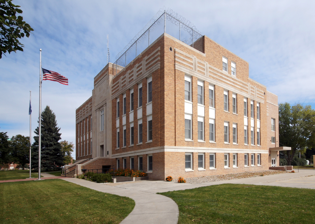
#14. Butler County, Nebraska
– Overall Rank: 678
– Population: 8,373
– Median household income: $75,690
– Median home value: $150,400 (81% own)
– Median rent: $740 (19% rent)
– Top public schools: Bellwood Elementary School (grade A minus), David City Elementary School (grade B+), David City Secondary School (grade B+)
– Top private schools: Aquinas High School (grade B minus), St. Mary’s School (grade unavailable)
– Top places: David City (grade A minus), Ulysses Township (grade A minus), Linwood Township (grade B+)
About
Butler County, Nebraska is located in the eastern part of the state, where prairies and farmland form the foundation of its landscape. David City, the county seat, highlights both historic charm and cultural vitality, with preserved architecture and local institutions anchoring community life. The county’s heritage is tied to waves of European immigrants, whose traditions still shape festivals, churches, and civic organizations.
The economy is strongly agricultural, centered on corn, soybeans, and livestock production that connect to regional and state markets. Agribusiness and small industries provide added support, while retail and services sustain local needs. Butler County reflects a steady blend of immigrant heritage, farming tradition, and economic resilience.
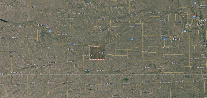
Where is Butler County?
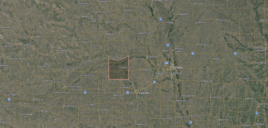
Butler County is located in eastern Nebraska, bordered by Platte County to the north and Seward County to the south. It sits about 60 miles west of Omaha and nearly 45 miles northwest of Lincoln. The county’s geography consists of fertile plains, farmland, and the Platte River forming part of its northern boundary.
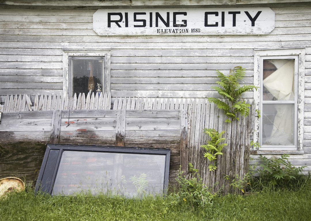
David City serves as the county seat and lies near the center of the county. Other towns such as Rising City, Bellwood, and Brainard contribute to its small-town character and agricultural economy. With state highways providing access to larger cities, the county balances rural life with regional connectivity.
#13. Holt County, Nebraska
– Overall Rank: 676
– Population: 10,149
– Median household income: $66,325
– Median home value: $148,900 (72% own)
– Median rent: $741 (28% rent)
– Top public schools: Atkinson Elementary School (grade A minus), West Holt High School (grade A minus), Chambers High School (grade B+)
– Top private schools: St. Mary’s Catholic Schools (grade B minus), St. Joseph Elementary School (grade unavailable), Word of Life Christian School (grade unavailable)
– Top places: O’Neill (grade B+), Atkinson Township (grade A minus), Inman Township (grade A minus)
About
Holt County, Nebraska covers a vast stretch of the north-central Sandhills, where open rangeland and prairies define its character. O’Neill, the county seat, is widely recognized for its Irish heritage, celebrated each year with parades, festivals, and cultural traditions that give the area a distinct identity. Historic churches, schools, and civic spaces highlight the deep roots of settlement across the county.
The economy is dominated by cattle ranching and farming, supported by the unique grasslands of the Sandhills. Livestock markets, agriculture-related businesses, and local services provide stability for the rural population. Holt County stands as a stronghold of ranching culture, shaped by both its heritage and the land that sustains it.
Where is Holt County?
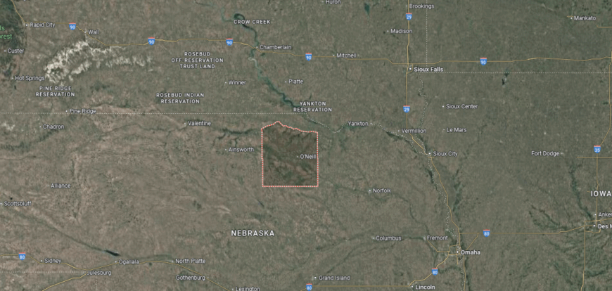
Holt County is located in north-central Nebraska, bordered by Boyd County to the north and Wheeler County to the south. It is one of the largest counties in the state by area, stretching across the Niobrara River basin and the edge of the Sandhills. The terrain includes wide prairies, river valleys, and rolling grasslands suited for ranching and farming.
O’Neill serves as the county seat and is the largest community, often called the “Irish Capital of Nebraska.” Smaller towns such as Atkinson, Stuart, and Ewing provide additional centers of local life. With U.S. Highways 20 and 275 crossing the region, Holt County links the Sandhills to neighboring counties and eastern Nebraska.
#12. Washington County, Nebraska
– Overall Rank: 614
– Population: 20,884
– Median household income: $89,671
– Median home value: $265,800 (81% own)
– Median rent: $926 (19% rent)
– Top public schools: Blair North Elementary School (grade A), Deerfield Elementary School (grade A), Blair South Elementary School (grade A minus)
– Top private schools: St. Paul Lutheran School (grade unavailable)
– Top places: Blair (grade A minus), Washington Township (grade A minus), Arlington Township (grade B+)
About
Washington County, Nebraska lies along the Missouri River in the eastern part of the state, where bluffs, valleys, and fertile bottomlands shape its landscape. Blair, the county seat, serves as both a historic and civic hub, with landmarks, schools, and museums reflecting the area’s long development. The county’s location near Omaha adds to its regional influence while preserving a distinctly rural character.
Agriculture remains central to the economy, with corn, soybeans, and livestock production forming a strong base. Proximity to metropolitan markets has encouraged growth in industry, retail, and services, giving the county balance beyond its farming roots. Washington County reflects a blend of natural beauty, historic presence, and economic diversity.
Where is Washington County?
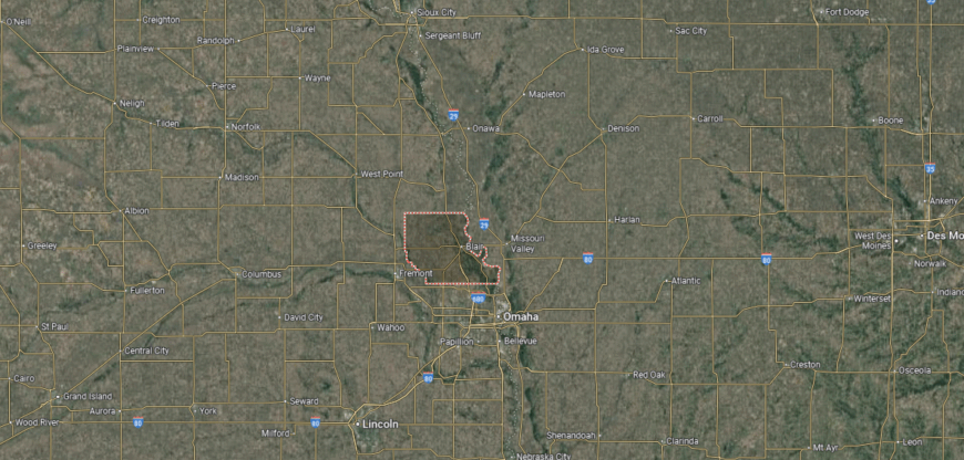
Washington County is positioned in eastern Nebraska, bordered by Burt County to the north and Douglas County to the south. It lies along the Missouri River, which forms its eastern boundary with the state of Iowa. The county’s landscape is a mix of river bluffs, fertile bottomlands, and gently rolling hills.
Blair serves as the county seat and is the largest community, located near the Missouri River. Smaller towns such as Fort Calhoun, Arlington, and Herman add to the county’s network of rural communities. With U.S. Highway 30 and proximity to Omaha, Washington County combines small-town character with strong regional connections.
#11. Fillmore County, Nebraska
– Overall Rank: 559
– Population: 5,557
– Median household income: $72,335
– Median home value: $122,700 (81% own)
– Median rent: $643 (19% rent)
– Top public schools: Fillmore Central High School (grade B+), Shickley Elementary School (grade B+), Exeter-Milligan High School (grade B)
– Top private schools: Grace Lutheran School (grade unavailable)
– Top places: Geneva Township (grade A), Geneva (grade A minus), Bennett Township (grade B+)
You may also like: Counties where the most opioids are dispensed in Nebraska
About
Fillmore County, Nebraska sits in the south-central part of the state, where broad prairies and fertile farmland define its identity. Geneva, the county seat, features historic architecture and serves as the center of civic and cultural life for surrounding communities. The county’s history reflects early settlement patterns tied closely to the land and its agricultural potential.
Farming anchors the economy, with corn, soybeans, and livestock production shaping local livelihoods and regional markets. Agribusiness, small manufacturing, and service industries provide additional strength while preserving the county’s rural character. Fillmore County represents the enduring balance of agricultural tradition, historic depth, and steady economic resilience.
Where is Fillmore County?
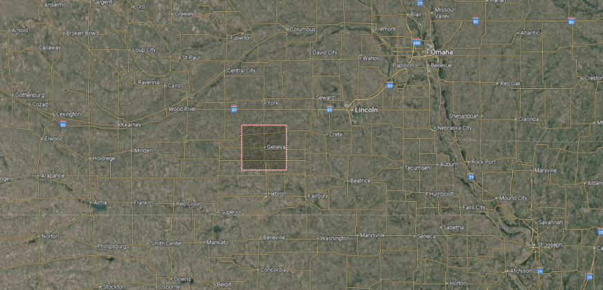
Fillmore County is located in southeastern Nebraska, bordered by York County to the north and Thayer County to the south. It lies about 70 miles southwest of Lincoln and roughly 125 miles southwest of Omaha. The county’s terrain consists of level to gently rolling plains, largely devoted to farming and agriculture.
Geneva serves as the county seat and sits near the center of the county along U.S. Highway 81. Smaller communities such as Exeter, Fairmont, and Shickley contribute to its rural character and economy. With major highways crossing the region, Fillmore County connects local agriculture to broader state and regional markets.
#10. Cherry County, Nebraska
– Overall Rank: 525
– Population: 5,473
– Median household income: $62,373
– Median home value: $137,300 (57% own)
– Median rent: $832 (43% rent)
– Top public schools: Cody-Kilgore High School (grade A minus), Cody-Kilgore Middle School (grade A minus), Valentine Elementary School (grade A minus)
– Top private schools: Zion Lutheran School (grade unavailable)
– Top places: Valentine (grade B+), Cody (grade B), Merriman (grade C+)
About
Cherry County, Nebraska is the largest county in the state, stretching across the northern Sandhills with wide-open prairies, rangeland, and winding rivers. Valentine, the county seat, serves as a gateway to outdoor recreation, with nearby parks, rivers, and scenic byways that highlight the county’s natural beauty. The landscape is central to its identity, shaping both culture and daily life.
Ranching dominates the economy, with cattle production defining the county’s role in Nebraska’s livestock industry. Tourism also plays an important part, as visitors are drawn to the Niobrara River, wildlife areas, and the unique Sandhills terrain. Cherry County reflects the vast scale of the Great Plains, combining economic strength in ranching with a deep connection to land and nature.
Where is Cherry County?
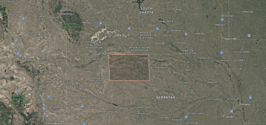
Cherry County is located in north-central Nebraska, stretching across the state’s Sandhills and reaching the South Dakota border to the north. It is the largest county in Nebraska by area, spanning wide prairies, rolling grass-covered dunes, and numerous rivers and streams. The Niobrara River cuts through the northern part of the county, offering scenic valleys and recreational opportunities.
Valentine serves as the county seat and is positioned near the Niobrara River, acting as the county’s commercial and cultural hub. Smaller communities such as Cody, Merriman, and Kilgore are scattered across the expansive landscape. With U.S. Highways 20 and 83 running through, Cherry County remains both a ranching stronghold and a gateway to the Sandhills’ natural beauty.
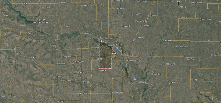
#9. Wayne County, Nebraska
– Overall Rank: 508
– Population: 9,701
– Median household income: $64,951
– Median home value: $176,200 (69% own)
– Median rent: $764 (31% rent)
– Top public schools: Wayne High School (grade B+), Wayne Elementary School (grade B+), Wayne Junior High School (grade B minus)
– Top private schools: St. Mary Elementary School (grade unavailable), Trinity Lutheran School (grade unavailable)
– Top places: Wayne (grade A minus), Carroll (grade B minus), Hoskins (grade B minus)
About
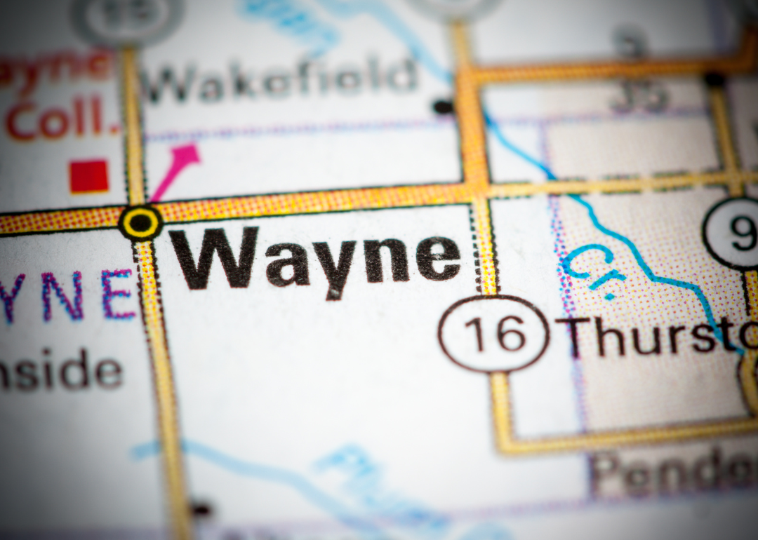
Wayne County, Nebraska rests in the northeastern part of the state, where fertile farmland and small towns form the foundation of daily life. Wayne, the county seat, is home to Wayne State College, which brings cultural, educational, and economic influence to the region. Historic neighborhoods, local festivals, and preserved landmarks highlight the county’s blend of tradition and progress.
Agriculture remains central to the economy, with corn, soybeans, and livestock production anchoring local markets. The presence of the college adds stability through education, research, and employment, while small businesses and services strengthen community life. Wayne County reflects a balance of rural heritage, academic influence, and steady economic growth.
Where is Wayne County?
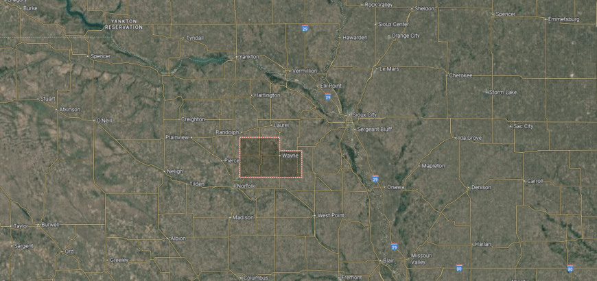
Wayne County is situated in northeastern Nebraska, bordered by Dixon County to the east and Stanton County to the west. It lies about 45 miles southwest of Sioux City, Iowa, and roughly 110 miles northwest of Omaha. The landscape includes fertile farmland, rolling hills, and small streams that support its agricultural base.
Wayne serves as the county seat and is home to Wayne State College, making it both an educational and cultural hub. Smaller communities such as Winside, Carroll, and Hoskins contribute to the county’s rural fabric. With state highways linking it to nearby regions, Wayne County balances small-town life with strong educational and economic ties.
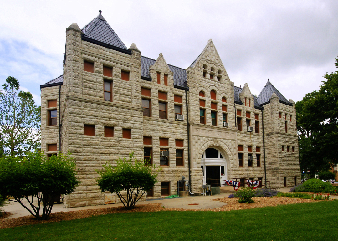
#8. Saline County, Nebraska
– Overall Rank: 482
– Population: 14,275
– Median household income: $71,104
– Median home value: $155,800 (74% own)
– Median rent: $763 (26% rent)
– Top public schools: Crete Elementary School (grade A), Tri County Elementary School (grade A minus), Friend Elementary School (grade B+)
– Top private schools: St. James Elementary School (grade unavailable)
– Top places: Crete (grade B+), De Witt (grade B+), Wilber (grade B)

About
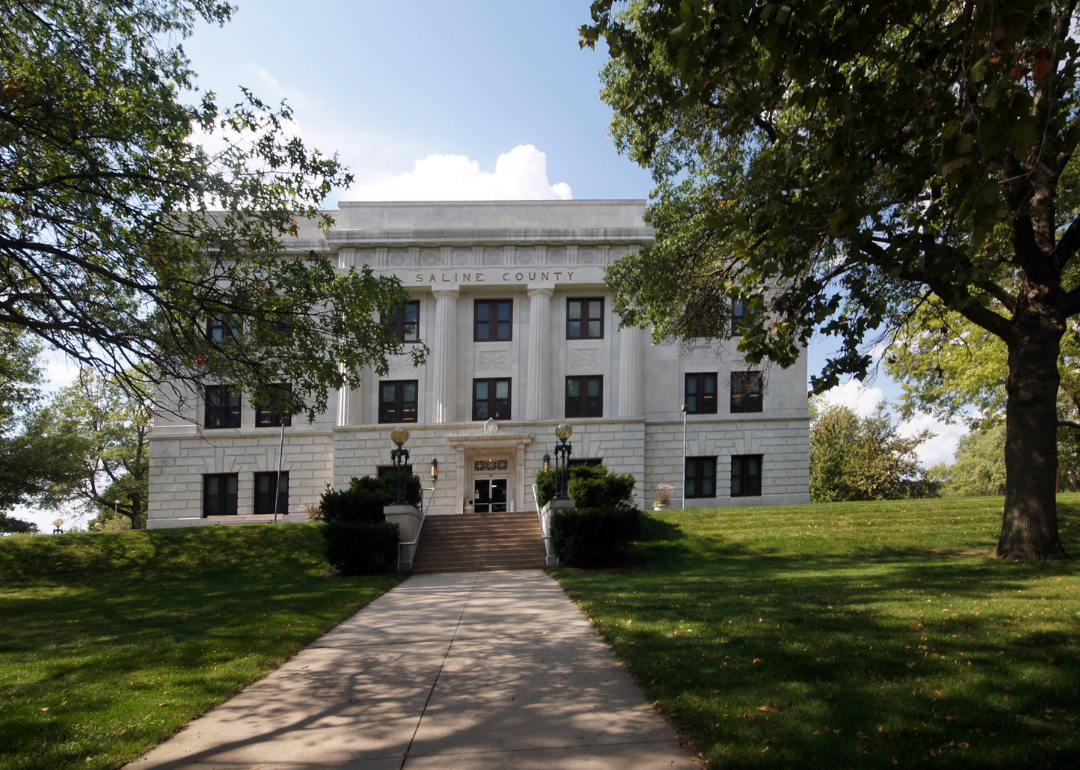
Saline County, Nebraska lies in the southeastern part of the state, where farmland and prairies provide the foundation for settlement and growth. Wilber, the county seat, is recognized as the “Czech Capital of the USA,” with festivals, cultural landmarks, and traditions that celebrate the heritage of its early settlers. Crete adds further influence as a hub of education, industry, and cultural diversity through Doane University.
Agriculture remains an important part of the economy, supported by corn, soybeans, and livestock production. Manufacturing, food processing, and education contribute additional strength, making the county’s economy both diverse and stable. Saline County reflects a unique blend of cultural heritage, academic presence, and agricultural tradition.
Where is Saline County?
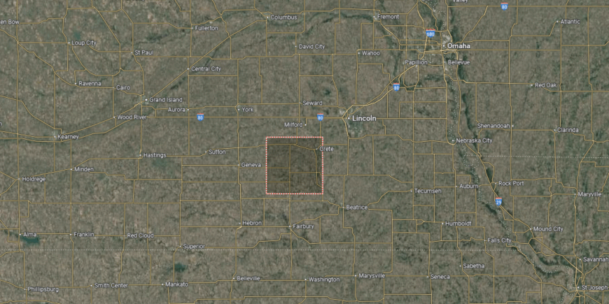
Saline County is located in southeastern Nebraska, bordered by Lancaster County to the north and Jefferson County to the south. It lies about 25 miles southwest of Lincoln and roughly 85 miles southwest of Omaha. The county’s terrain is characterized by rolling farmland, prairies, and creeks that flow into the Big Blue River.
Wilber serves as the county seat and is known as the “Czech Capital of the USA,” reflecting its cultural heritage. Crete, the largest city, is home to Doane University and serves as a center of commerce and education. Other towns such as Friend and DeWitt add to the county’s rural network and community life.
#7. Buffalo County, Nebraska
– Overall Rank: 350
– Population: 50,103
– Median household income: $70,093
– Median home value: $218,600 (66% own)
– Median rent: $885 (34% rent)
– Top public schools: Meadowlark Elementary School (grade A minus), Buffalo Hills Elementary School (grade A minus), Windy Hills Elementary School (grade A minus)
– Top private schools: Kearney Catholic High School (grade B+), Zion Lutheran School (grade unavailable), Faith Christian School of Kearney (grade unavailable)
– Top places: Kearney (grade A), Amherst (grade B+), Ravenna (grade B)
About
Buffalo County, Nebraska is situated in south-central Nebraska, with Kearney serving as its county seat and cultural center. The county’s history is tied to the Platte River and the westward migration, remembered through landmarks like Fort Kearny and the Great Platte River Road Archway Monument. Its landscape of rolling plains and river valleys provides both scenic beauty and fertile ground.
The economy is diverse, with agriculture—especially corn, soybeans, and cattle—forming the base, while manufacturing, healthcare, and education broaden its strength. The University of Nebraska at Kearney adds cultural and economic vitality, making the county a hub for the region. Buffalo County reflects a balance of historic depth, agricultural tradition, and modern growth.
Where is Buffalo County?
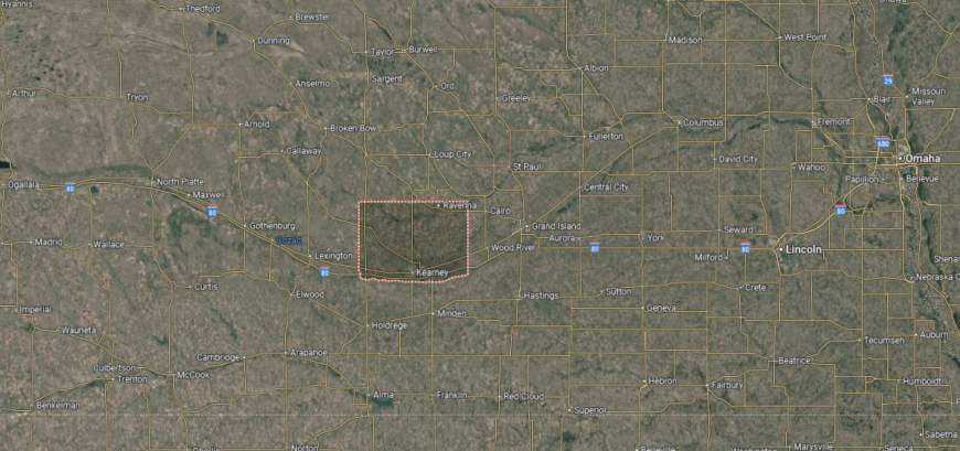
Buffalo County is located in south-central Nebraska, bordered by Sherman County to the north and Kearney County to the south. It lies about 130 miles west of Lincoln and roughly 180 miles west of Omaha. The Platte River flows across its southern edge, shaping both the land and the agricultural base of the county.
Kearney serves as the county seat and is the largest city, positioned along Interstate 80 as a regional hub. Other communities such as Elm Creek, Gibbon, and Shelton add to the county’s mix of rural and small-town life. With major highways and rail lines, Buffalo County is a key transportation and economic center in central Nebraska.
#6. Nemaha County, Nebraska
– Overall Rank: 329
– Population: 7,019
– Median household income: $57,196
– Median home value: $118,300 (70% own)
– Median rent: $657 (30% rent)
– Top public schools: Elementary School at Johnson (grade A), High School at Johnson (grade A minus), Auburn Middle School (grade B)
– Top private schools:
– Top places: Auburn (grade B+), Peru (grade A minus), Johnson (grade A minus)
You may also like: Healthy hotspots: The most physically active counties in Nebraska
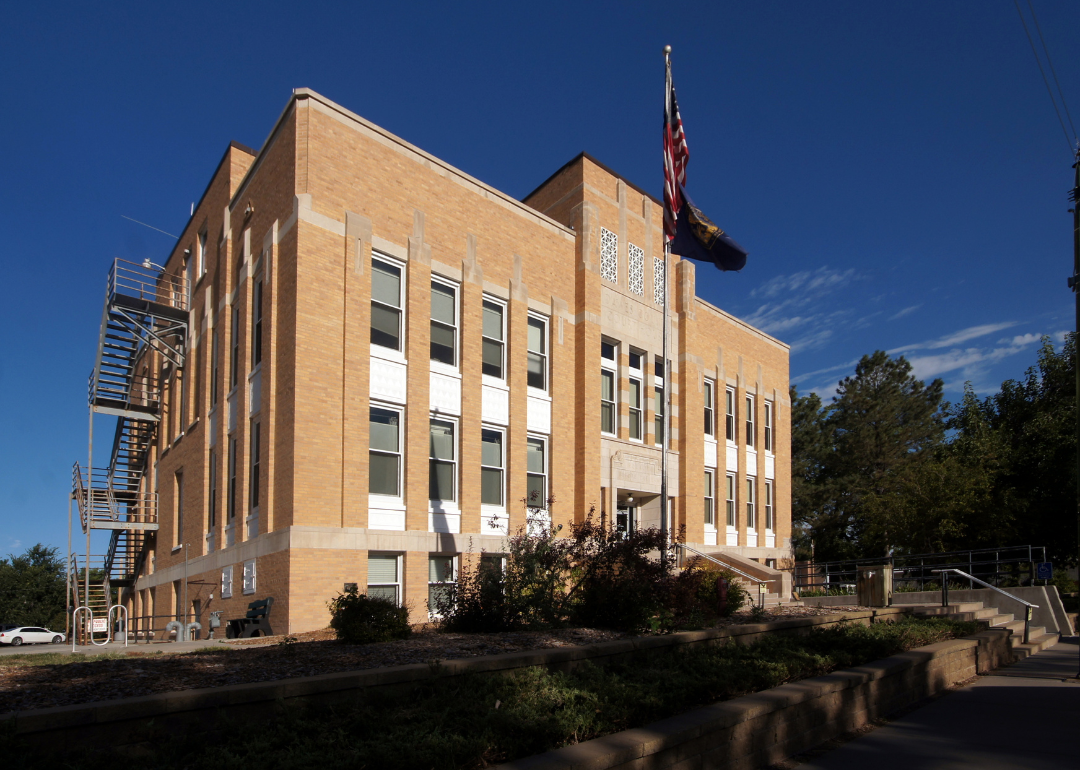
About
Nemaha County, Nebraska sits along the Missouri River in the southeastern part of the state, where bluffs, valleys, and fertile farmland define its landscape. Auburn, the county seat, serves as the civic and cultural center, with historic buildings, schools, and community traditions shaping local identity. The county’s riverside setting ties it closely to both history and natural resources.
Agriculture anchors the economy, with corn, soybeans, and livestock forming the backbone of production. Small industries, retail, and local services support regional stability, while proximity to the river adds opportunities for trade and recreation. Nemaha County reflects a blend of agricultural strength, historic presence, and steady rural resilience.
Where is Nemaha County?
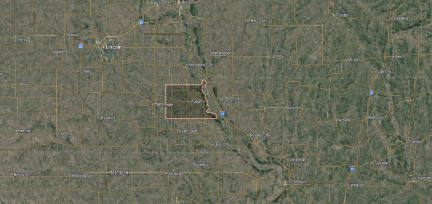
Nemaha County is situated in southeastern Nebraska, bordered by Otoe County to the north and Richardson County to the south. The Missouri River forms its eastern boundary, creating a natural border with the state of Missouri. The county’s geography includes river bluffs, fertile bottomlands, and rolling farmland.
Auburn serves as the county seat and is the largest community, positioned near the center of the county. Smaller towns such as Peru, Johnson, and Julian contribute to its rural network, with Peru also home to Peru State College. With U.S. Highways 75 and 136 passing through, Nemaha County connects easily to nearby states and regional markets.
#5. Dawes County, Nebraska
– Overall Rank: 277
– Population: 8,279
– Median household income: $53,760
– Median home value: $142,100 (63% own)
– Median rent: $887 (37% rent)
– Top public schools: Chadron Middle School (grade A minus), Chadron Senior High School (grade B+), Chadron Intermediate School (grade B minus)
– Top private schools:
– Top places: Chadron (grade A), Crawford (grade B minus)
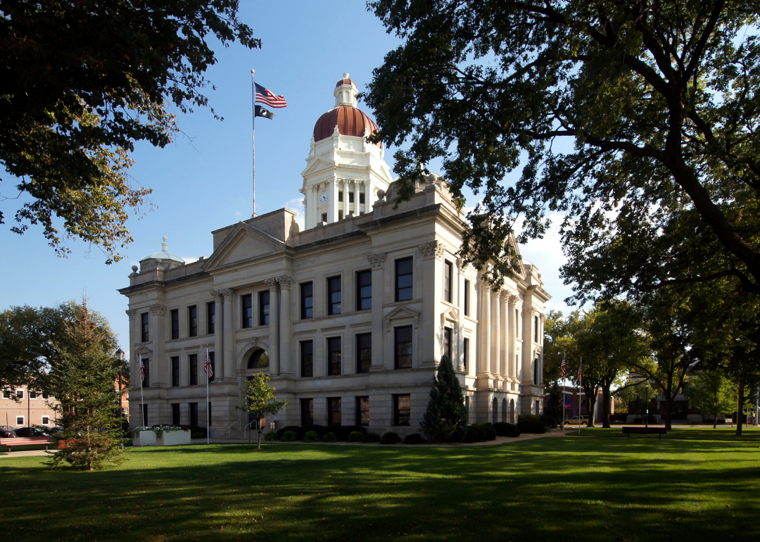
About
Dawes County, Nebraska lies in the northwestern Panhandle, where the rugged Pine Ridge region sets it apart with buttes, canyons, and forested hills. Chadron, the county seat, is home to Chadron State College, which brings educational and cultural influence while also strengthening the local economy. Historic sites, including ties to Native American history and frontier settlement, add depth to the county’s identity.
Ranching and farming remain central to the economy, supported by cattle, crops, and the use of natural grasslands. Tourism contributes as well, with Chadron State Park, the Museum of the Fur Trade, and scenic landscapes drawing visitors to the region. Dawes County combines natural beauty, educational presence, and strong agricultural traditions into a distinctive character.
Where is Dawes County?
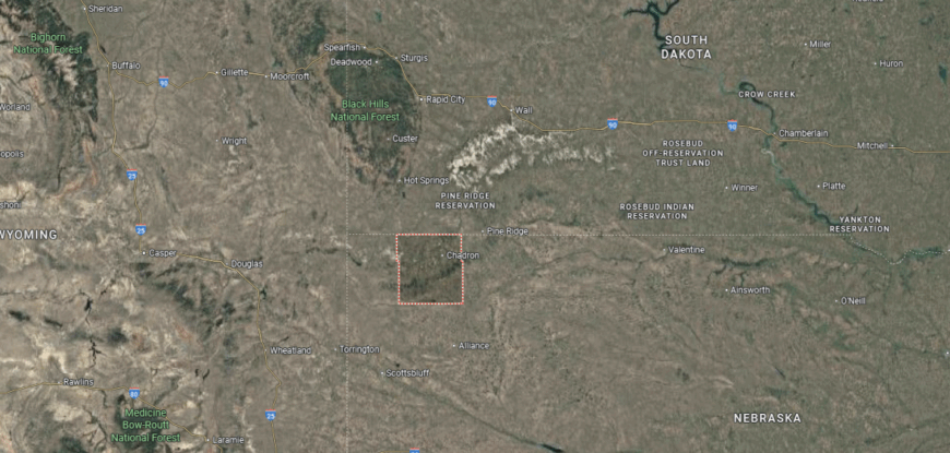
Dawes County is located in the northwestern corner of Nebraska, bordered by Sioux County to the west and Box Butte County to the south. It shares its northern boundary with South Dakota, placing it within the Pine Ridge region. The county’s landscape features buttes, canyons, and stretches of the Pine Ridge National Forest.
Chadron serves as the county seat and is the largest community, positioned along U.S. Highways 20 and 385. Crawford, another notable town, sits near Fort Robinson State Park, a site of both historical and recreational importance. With its mix of natural scenery and small communities, Dawes County is a gateway to the Nebraska Panhandle’s rugged beauty.
#4. Seward County, Nebraska
– Overall Rank: 265
– Population: 17,644
– Median household income: $79,677
– Median home value: $208,700 (73% own)
– Median rent: $916 (27% rent)
– Top public schools: Seward Middle School (grade A), Seward Elementary School (grade A minus), Seward High School (grade B+)
– Top private schools: St. John Lutheran School (grade unavailable), St. Paul Lutheran School (grade unavailable), St. Vincent de Paul School (grade unavailable)
– Top places: Seward (grade A), Milford (grade A minus), Staplehurst (grade B+)

About
Seward County, Nebraska rests in the southeastern part of the state, where prairies and farmland stretch across a landscape shaped by generations of farming. Seward, the county seat, is nationally recognized for its large Fourth of July celebration, which reflects both tradition and civic pride. The presence of Concordia University adds cultural and educational influence, making the county a regional center of activity.
Agriculture forms the backbone of the economy, with corn, soybeans, and livestock at the forefront. Agribusiness, small industries, and service sectors provide added strength, while the university supports stability through education and employment. Seward County blends patriotic heritage, agricultural tradition, and academic presence into a well-rounded identity.
Where is Seward County?
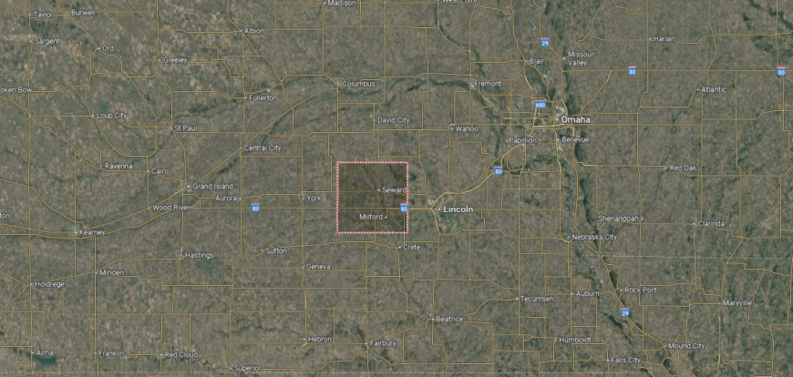
Seward County is positioned in southeastern Nebraska, bordered by Butler County to the north and Saline County to the south. It lies about 25 miles west of Lincoln and nearly 90 miles southwest of Omaha. The county’s terrain includes rolling farmland, prairies, and small streams that feed into the Big Blue River.
Seward serves as the county seat and is located near the center of the county along U.S. Highway 34. Milford and Utica are other key communities, contributing to the county’s educational and agricultural life, with Milford home to a Nebraska Community College campus. With its close proximity to Lincoln and easy access to Interstate 80, Seward County combines rural traditions with strong regional connections.
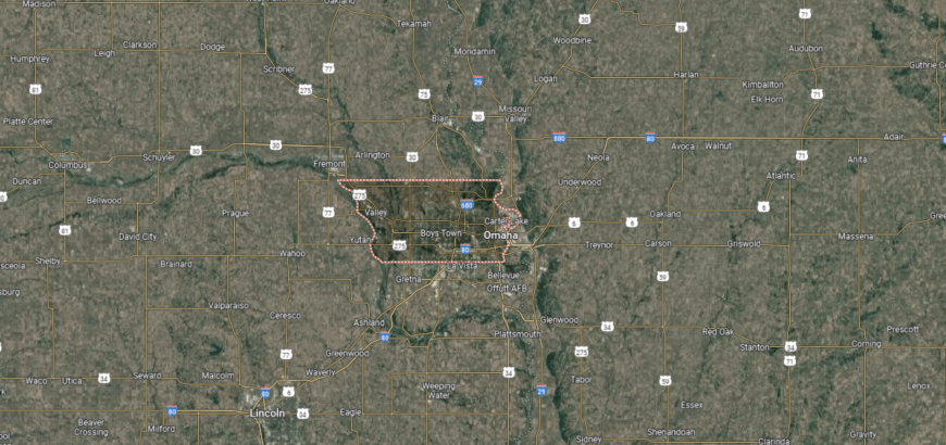
#3. Sarpy County, Nebraska
– Overall Rank: 146
– Population: 191,272
– Median household income: $95,911
– Median home value: $263,000 (70% own)
– Median rent: $1,203 (30% rent)
– Top public schools: Upchurch Elementary School (grade A), Liberty Middle School (grade A), Portal Elementary School (grade A)
– Top private schools: Gross Catholic High School (grade A minus), Cornerstone Christian School (grade B), St. Columbkille School (grade unavailable)
– Top places: Papillion (grade A), Gretna (grade A), La Vista (grade A)
About
Sarpy County, Nebraska, the smallest by land area in the state, is one of the fastest growing due to its position within the Omaha metropolitan region. Papillion, the county seat, along with Bellevue and La Vista, anchors a mix of suburban life, historic roots, and modern development. The Missouri River and Offutt Air Force Base add both strategic importance and cultural character to the county.
The economy is broad and dynamic, driven by military presence, technology, retail, and service industries, while suburban growth continues to expand housing and commerce. Small businesses and local institutions complement this momentum, ensuring balance between tradition and progress. Sarpy County reflects the vitality of a growing metropolitan community grounded in history and strengthened by economic diversity.
Where is Sarpy County?
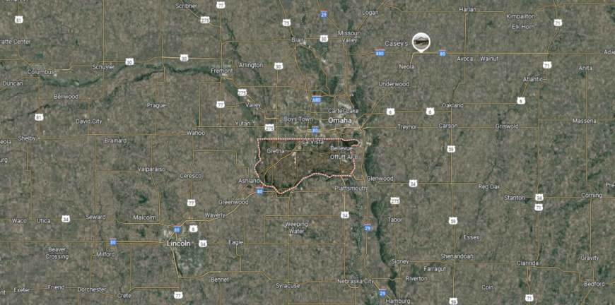
Sarpy County is located in eastern Nebraska, bordered by Douglas County to the north and Cass County to the south. It lies along the Missouri River, which forms its eastern boundary with the state of Iowa. The county is the smallest in Nebraska by land area but one of the fastest-growing due to its suburban expansion.
Papillion serves as the county seat and is part of the Omaha metropolitan area. Other major communities include Bellevue, La Vista, and Gretna, each contributing to the county’s rapid residential and commercial development. With Interstate 80 and Offutt Air Force Base nearby, Sarpy County holds both strategic and economic importance in the region.
#2. Lancaster County, Nebraska
– Overall Rank: 137
– Population: 322,063
– Median household income: $70,387
– Median home value: $239,900 (59% own)
– Median rent: $997 (41% rent)
– Top public schools: Lincoln East High School (grade A), Moore Middle School (grade A), Lux Middle School (grade A)
– Top private schools: Pius X High School (grade A minus), Lincoln Christian School (grade B+), Parkview Christian Schools (grade B+)
– Top places: Lincoln (grade A), Waverly (grade A minus), Yankee Hill (grade A minus)
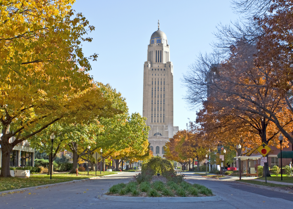
About
Lancaster County, Nebraska is home to Lincoln, the state capital, which serves as both the cultural and political heart of the region. Historic neighborhoods, museums, and performing arts venues reflect a strong civic identity, while the University of Nebraska–Lincoln adds academic influence and statewide recognition. The county’s landscape of rolling plains and woodlands provides a balance between urban energy and natural beauty.
Its economy is one of the most diverse in Nebraska, anchored by government, education, healthcare, and technology. Agriculture continues to contribute, though industry, research, and retail have expanded the county’s reach. Lancaster County blends historic importance, cultural vitality, and economic strength into a defining presence for the state.
Where is Lancaster County?
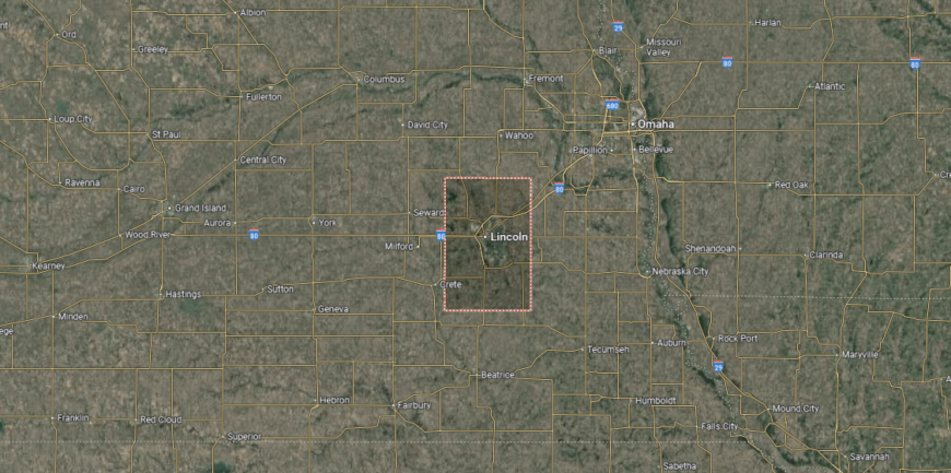
Lancaster County is located in southeastern Nebraska, bordered by Saunders County to the north and Gage County to the south. It lies about 55 miles southwest of Omaha and serves as home to Lincoln, the state capital. The county’s geography is made up of rolling plains, farmland, and creeks that flow into the Salt Creek watershed.
Lincoln serves as both the county seat and the largest city, functioning as Nebraska’s center for government, education, and culture. Smaller communities such as Waverly, Hickman, and Denton add to the county’s suburban and rural mix. With Interstate 80 and multiple highways running through, Lancaster County is a major hub of travel and commerce in the state.
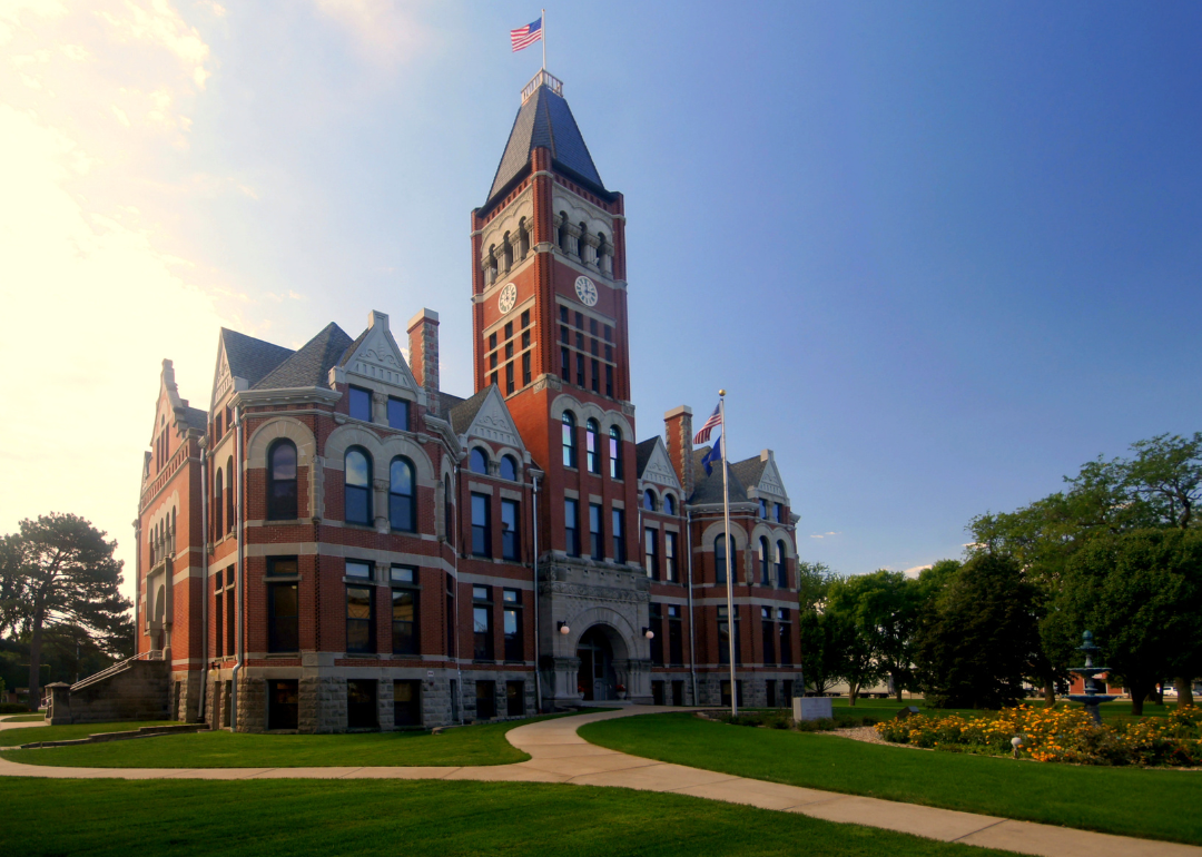
#1. Douglas County, Nebraska
– Overall Rank: 79
– Population: 582,638
– Median household income: $76,083
– Median home value: $227,400 (62% own)
– Median rent: $1,109 (38% rent)
– Top public schools: Blue Sage Elementary School (grade A+), Woodbrook Elementary School (grade A+), Sagewood Elementary School (grade A+)
– Top private schools: Brownell Talbot College Preparatory School (grade A+), Mount Michael Benedictine High School (grade A+), Marian High School (grade A)
– Top places: Omaha (grade A), Bennington (grade A minus), Ralston (grade B+)

About
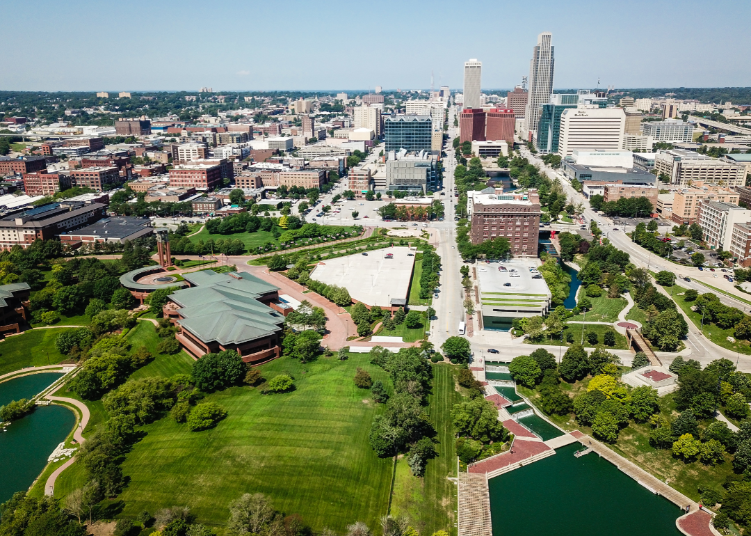
Douglas County, Nebraska is the most populous in the state, with Omaha as its county seat and metropolitan core. The county’s identity is shaped by its historic role as a gateway to the west, visible in preserved districts, museums, and cultural landmarks that reflect both settlement and innovation. The Missouri River frames its eastern border, tying the region to trade, transportation, and commerce.
The economy is the most diverse in Nebraska, built on finance, healthcare, education, and transportation, alongside strong agricultural ties. Omaha’s role as a corporate center adds national influence, while small businesses and cultural institutions enrich local life. Douglas County stands as Nebraska’s economic and cultural hub, blending history, progress, and metropolitan vitality.
Where is Douglas County?
Douglas County is located in eastern Nebraska, bordered by Washington County to the north and Sarpy County to the south. The Missouri River forms its eastern boundary, separating it from the state of Iowa. It is the most populous county in Nebraska, with a landscape that transitions from river lowlands to developed urban areas.
Omaha serves as the county seat and is the largest city in the state, positioned along the Missouri River. Other communities such as Bennington, Ralston, and Valley add to the county’s suburban and small-town network. With Interstate 80, Eppley Airfield, and major rail lines, Douglas County is a central hub of commerce, transportation, and culture in Nebraska.
This story features data reporting and writing by Elena Cox and is part of a series utilizing data automation across 50 states.
You may also like: Cities with the fastest-growing home prices in Nebraska
By Stacker