
🔥 Would you like to save this?
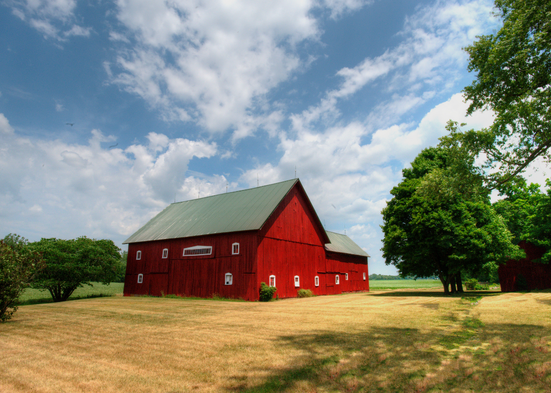
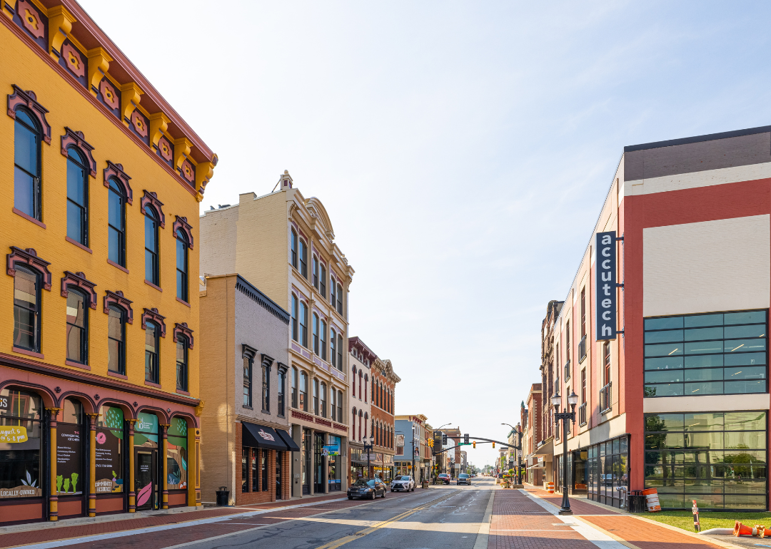
Best counties to live in Indiana – selections based on a variety of factors including median home values.
More counties in the United States experienced population growth in the last year, according to the latest Census data, even as pandemic-related moving trends begin to normalize.
Counties in the South continued to experience growth, particularly in Florida, where 96% of its 67 counties gained new residents. Polk County, Florida, a suburb of Orlando, added the most, with 26,000 people moving there in 2023.
In order to come up with the very specific design ideas, we create most designs with the assistance of state-of-the-art AI interior design software.
Meanwhile, counties in the Midwest and Northeast continued to lose population, but at slower rates than the year before. Some of the biggest losses were in counties home to large cities, including Cook County, Illinois (home of Chicago) and the boroughs of Brooklyn and Queens in New York.
Many counties are experiencing growth due to their job opportunities, education, or relatively affordable housing costs. Others are favored for their historic or well-designed downtowns or access to cultural opportunities.
Stacker compiled a list of the best counties to live in Indiana using rankings from Niche. Niche ranks counties by various factors including public schools, educational attainment, cost of living, and housing (i.e. home prices and mortgage affordability).
Keep reading to see if your county made the list.
You may also like: Best public high schools in Indiana
#30. Marshall County, Indiana
– Overall Rank: 873
– Population: 46,208
– Median household income: $66,016
– Median home value: $170,800 (76% own)
– Median rent: $882 (24% rent)
– Top public schools: Jefferson Elementary School (grade B+), Plymouth High School (grade B+), Triton Junior/Senior High School (grade B+)
– Top private schools: Culver Academies (grade A+), St. Michael School (grade unavailable), St. Paul’s Lutheran School and Preschool (grade unavailable)
– Top places: Bremen (grade A), Plymouth (grade B+), Bourbon (grade A minus)

About
Marshall County’s economy benefits from a strong manufacturing base, supported by agriculture, retail trade, and a growing service sector. Investment in infrastructure, workforce development, and business-friendly initiatives continues to attract both established companies and entrepreneurial ventures.
The county’s strategic location within northern Indiana supports steady economic activity and regional connectivity. Cultural life includes seasonal festivals, community gatherings, and events that reflect the area’s Midwestern heritage.
Residents have access to parks, lakes, and outdoor recreation that encourage an active lifestyle. Quality schools, public safety services, and active civic organizations help maintain a welcoming and family-oriented environment.
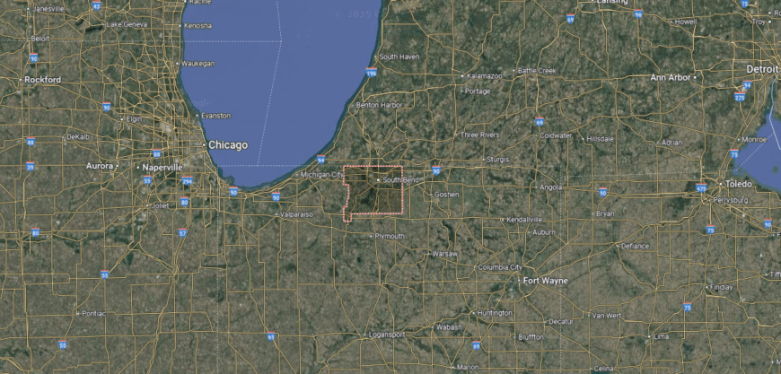
Where is Marshall County?
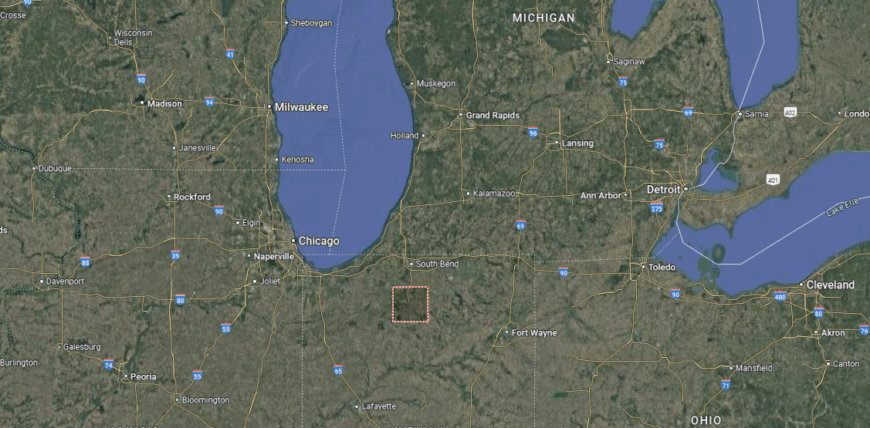
Marshall County is located in north-central Indiana, bordered by St. Joseph County to the north and Kosciusko County to the east. The county seat, Plymouth, lies about 25 miles south of South Bend and roughly 90 miles north of Indianapolis.
U.S. Route 30 runs east–west across the county, while U.S. Route 31 provides a major north–south connection through Plymouth. The landscape is a mix of farmland, small towns, and natural features such as Lake Maxinkuckee near Culver, one of Indiana’s largest natural lakes, and the Tippecanoe River. These features, along with state parks and rural highways, shape both the county’s travel routes and its recreational appeal.
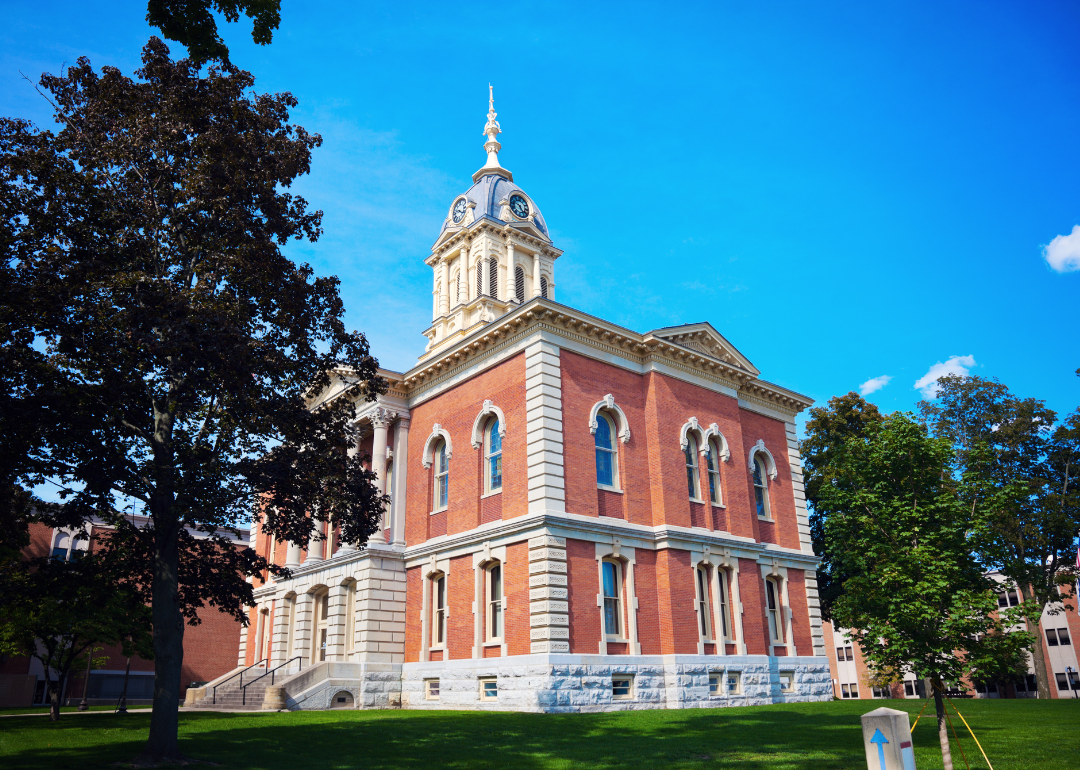
#29. Wabash County, Indiana
– Overall Rank: 859
– Population: 31,032
– Median household income: $66,194
– Median home value: $135,800 (79% own)
– Median rent: $731 (21% rent)
– Top public schools: Manchester Elementary School (grade A), Sharp Creek Elementary School (grade B+), Southwood Elementary School (grade B)
– Top private schools: Emmanuel Christian School (grade C+), St. Bernard Elementary School (grade unavailable)
– Top places: North Manchester (grade A), Wabash (grade B+), Chester Township (grade A minus)
About
Wabash County combines a rich industrial heritage with a forward-looking approach to economic growth. Manufacturing remains a key driver, joined by healthcare, education, and small business ventures that strengthen the local economy.
Strategic development projects focus on revitalizing downtown areas, enhancing transportation links, and encouraging innovation. The community’s cultural identity is shaped by historic landmarks, performing arts venues, and annual events that bring residents together.
Scenic riverfronts, trails, and nature preserves offer opportunities for outdoor recreation year-round. Strong schools, active volunteer networks, and an emphasis on preserving local history create a sense of pride and belonging for those who call Wabash County home.
Where is Wabash County?
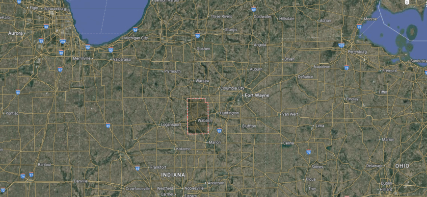
Wabash County is located in north-central Indiana, along the Wabash River. The county seat, also named Wabash, lies about 45 miles southwest of Fort Wayne and roughly 85 miles north of Indianapolis. It is positioned around 25 miles west of Huntington.
The county is bordered by Miami County to the north and Grant County to the south. U.S. Route 24 and State Road 15 intersect in Wabash, providing convenient connections to nearby cities and rural communities. The Wabash River and surrounding farmland shape much of the county’s landscape and travel routes.
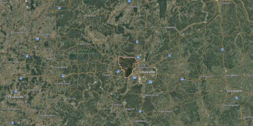
#28. Clark County, Indiana
– Overall Rank: 808
– Population: 121,484
– Median household income: $69,005
– Median home value: $195,100 (74% own)
– Median rent: $1,002 (26% rent)
– Top public schools: Pleasant Ridge Elementary School (grade A minus), Utica Elementary School (grade A minus), Silver Creek High School (grade B+)
– Top private schools: Our Lady of Providence Junior/Senior High School (grade B+), St. John Paul II Catholic School (grade unavailable), St. Anthony Elementary School (grade unavailable)
– Top places: Jeffersonville (grade A minus), Sellersburg (grade B+), Clarksville (grade B+)

About
Clark County benefits from its position along the Ohio River, fostering a diverse economy anchored by manufacturing, logistics, healthcare, and retail. Proximity to the Louisville metropolitan area enhances business opportunities while supporting steady population growth.
Ongoing investments in infrastructure and commercial development aim to balance economic expansion with community needs. Cultural offerings range from riverfront festivals and music events to local markets that highlight regional flavors.
Residents enjoy parks, walking trails, and recreational facilities that encourage active living. Strong educational resources, public services, and civic engagement contribute to a dynamic environment that blends small-town charm with metropolitan access.
Where is Clark County?
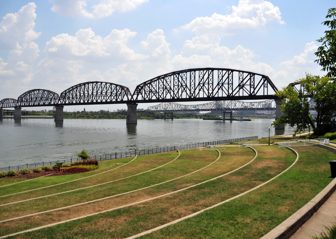
Clark County sits in the southernmost part of Indiana, along the Ohio River. The county seat, Jeffersonville, is located directly across the river from Louisville, Kentucky, and about 110 miles south of Indianapolis. It lies roughly 50 miles west of Madison.
The county shares its southern border with Kentucky, connected by several bridges spanning the Ohio River. Interstate 65 runs through Jeffersonville, linking the area to major regional highways. Riverfront areas and proximity to the Louisville metropolitan region make Clark County a key connection point between Indiana and Kentucky.
#27. Montgomery County, Indiana
– Overall Rank: 802
– Population: 38,018
– Median household income: $62,937
– Median home value: $156,400 (75% own)
– Median rent: $787 (25% rent)
– Top public schools: Ladoga Elementary School (grade A minus), New Market Elementary School (grade A minus), Sugar Creek Elementary School (grade A minus)
– Top private schools:
– Top places: Crawfordsville (grade B), Brown Township (grade A minus), Lake Holiday (grade A minus)
About
Montgomery County’s economy is anchored by manufacturing, agriculture, and a growing service sector, supported by its strategic location in west-central Indiana. Local development initiatives emphasize workforce training, infrastructure improvements, and support for entrepreneurial growth.
The county’s transportation access and business-friendly environment continue to attract both established industries and new ventures. Cultural life reflects a blend of historic preservation and community traditions, with events, fairs, and festivals that celebrate local heritage.
Parks, trails, and recreational facilities provide year-round opportunities for outdoor activities. Strong schools, public safety, and active community organizations foster a connected and family-oriented atmosphere.
Where is Montgomery County?
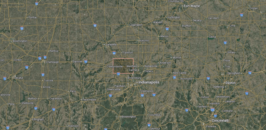
Montgomery County is situated in west-central Indiana. The county seat, Crawfordsville, lies about 45 miles northwest of Indianapolis and roughly 35 miles south of Lafayette. It is positioned around 25 miles east of the Illinois state line.
U.S. Route 231 and Interstate 74 cross through the county, offering direct routes to both urban centers and rural areas. Surrounded by farmland and intersected by Sugar Creek, Montgomery County blends easy highway access with a predominantly agricultural landscape.
#26. Spencer County, Indiana
– Overall Rank: 786
– Population: 19,935
– Median household income: $66,168
– Median home value: $168,200 (80% own)
– Median rent: $715 (20% rent)
– Top public schools: Heritage Hills Middle School (grade A), Nancy Hanks Elementary School (grade A), Chrisney Elementary School (grade A)
– Top private schools: St. Bernard School (grade unavailable)
– Top places: Clay Township (grade A), Santa Claus (grade A), Huff Township (grade A minus)
You may also like: Highest-rated wineries in Indiana, according to Yelp

About
Spencer County blends agricultural strength with expanding tourism, manufacturing, and small business development. Its location along the Ohio River supports commerce and offers access to regional markets, while community planning focuses on sustainable growth and economic diversity.
Investment in infrastructure and local initiatives continues to create opportunities for residents and businesses alike. The county is known for historic sites, cultural attractions, and seasonal events that highlight its heritage.
Outdoor recreation thrives through river access, parks, and nature trails that invite exploration. Quality schools, strong public services, and a close-knit community spirit contribute to a welcoming environment for families and newcomers.
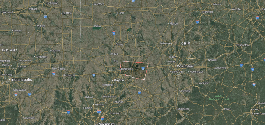
Where is Spencer County?
Spencer County is located in the southwestern corner of Indiana, along the Ohio River. The county seat, Rockport, sits about 50 miles east of Evansville and roughly 80 miles west of Louisville, Kentucky. It is positioned near the state’s southern border, opposite Owensboro, Kentucky.
The county is served by U.S. Route 231 and State Road 66, providing riverfront and inland access. Its location along the Ohio River shapes both travel routes and local industry, with nearby attractions and small towns connected by scenic rural highways.
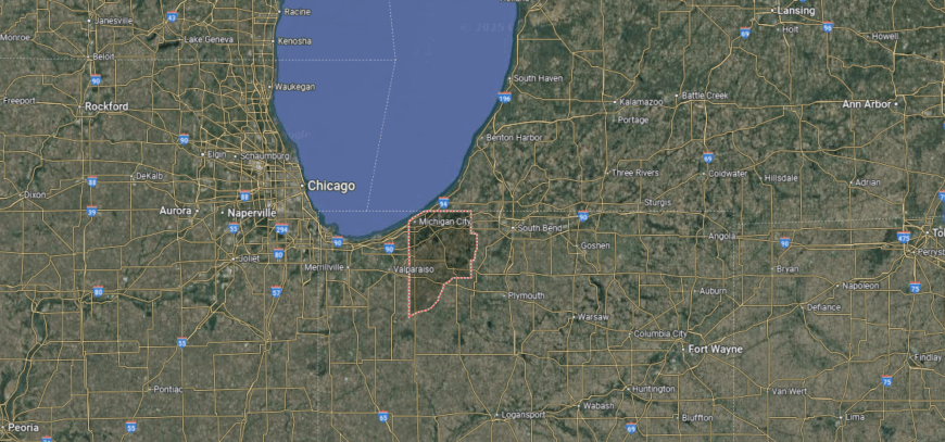
#25. LaPorte County, Indiana
– Overall Rank: 781
– Population: 112,215
– Median household income: $66,854
– Median home value: $166,200 (74% own)
– Median rent: $860 (26% rent)
– Top public schools: Prairie View Elementary School (grade A minus), Rolling Prairie Elementary School (grade A minus), F. Willard Crichfield Elementary School (grade A minus)
– Top private schools: La Lumiere School (grade A+), Marquette Catholic High School (grade A+), Sacred Heart Apostolic School (grade A)
– Top places: Long Beach (grade B+), Michigan City (grade B+), La Porte (grade B)
About
LaPorte County benefits from a diverse economy supported by manufacturing, healthcare, tourism, and port-related industries. Its location on the southern shore of Lake Michigan offers strategic access to regional transportation routes, fostering trade and attracting investment.
Economic development efforts prioritize workforce readiness, infrastructure upgrades, and sustainable business growth. Cultural life is enriched by lakefront events, arts programming, and festivals that reflect the county’s mix of heritage and innovation.
Residents enjoy beaches, parks, and nature preserves that encourage outdoor recreation in every season. Strong schools, active civic organizations, and engaged neighborhoods create a balanced environment that values both progress and community connection.
Where is LaPorte County?
🔥 Would you like to save this?
LaPorte County lies in the northwestern part of Indiana, bordering the southern shore of Lake Michigan. The county seat, LaPorte, is located about 60 miles east of Chicago, Illinois, and roughly 30 miles west of South Bend. Michigan City, the county’s other major city, sits directly on the lakefront.
Interstate 94, U.S. Route 20, and the Indiana Toll Road (I-80/I-90) run through the county, offering regional and interstate connections. Its location along Lake Michigan provides both transportation advantages and access to nearby coastal and recreational areas.
#24. Tipton County, Indiana
– Overall Rank: 776
– Population: 15,328
– Median household income: $71,947
– Median home value: $150,700 (81% own)
– Median rent: $842 (19% rent)
– Top public schools: Tipton Elementary School (grade B+), Tipton Middle School (grade B), Tri Central Middle/High School (grade B minus)
– Top private schools: St. John the Baptist School (grade unavailable)
– Top places: Tipton (grade B+), Jefferson Township (grade A minus), Prairie Township (grade A minus)

About
Tipton County maintains a strong agricultural base while encouraging growth in manufacturing, renewable energy, and small business ventures. Its central Indiana location provides easy access to major markets, supporting steady economic activity and attracting new investment.
Local development strategies focus on infrastructure, workforce skills, and preserving the county’s rural character alongside economic progress. Community life is shaped by local fairs, seasonal festivals, and events that showcase farming traditions and regional pride.
Parks, sports facilities, and open spaces offer opportunities for recreation and gathering. Quality schools, responsive public services, and active civic groups contribute to a safe, connected, and family-friendly atmosphere.
Where is Tipton County?
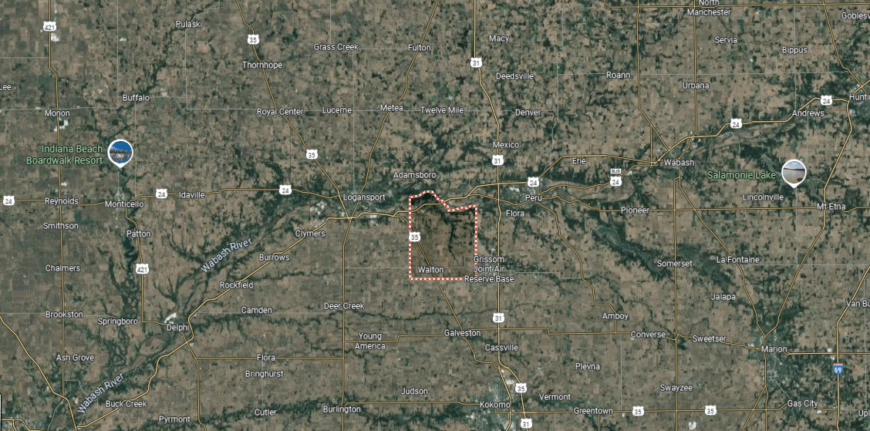
Tipton County is situated in central Indiana, surrounded entirely by farmland. The county seat, Tipton, lies about 35 miles north of Indianapolis and roughly 20 miles south of Kokomo. It is positioned around 50 miles east of Lafayette.
State Roads 28 and 19 intersect in Tipton, creating direct routes to neighboring counties and regional hubs. With no major rivers or lakes, the county’s geography is defined by its flat agricultural terrain and grid of rural highways.
#23. Vigo County, Indiana
– Overall Rank: 712
– Population: 106,355
– Median household income: $52,789
– Median home value: $130,300 (63% own)
– Median rent: $853 (37% rent)
– Top public schools: Terre Haute South Vigo High School (grade B+), Fayette Elementary School (grade B+), Adelaide DeVaney Elementary School (grade B+)
– Top private schools: St. Patrick Elementary School (grade unavailable), Holy Cross School (grade unavailable), Bible Baptist Academy (grade unavailable)
– Top places: North Terre Haute (grade B), Terre Haute (grade B), West Terre Haute (grade C+)

About
Vigo County combines the energy of a regional economic center with the character of a historic Midwestern community. The presence of universities, major healthcare providers, and manufacturing facilities drives employment and fosters long-term stability.
Strategic location along key transportation routes supports commerce and positions the county as a link between Indiana and surrounding states. Local culture blends academic influence with hometown traditions, offering a calendar filled with art exhibitions, heritage celebrations, and live performances.
Outdoor options range from riverside trails to community parks, providing space for recreation and gathering. Strong civic involvement and a focus on quality-of-life amenities help make Vigo County a place where economic opportunity and community spirit grow together.
Where is Vigo County?
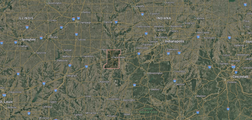
Vigo County is located in western Indiana along the Wabash River, bordering Illinois. The county seat, Terre Haute, sits about 75 miles west of Indianapolis and roughly 180 miles southeast of Chicago. It lies directly across the state line from Paris, Illinois.
Interstate 70 runs east–west through Terre Haute, linking the area to Indianapolis and St. Louis. U.S. Routes 41 and 150 provide additional north–south connections. The Wabash River and surrounding lowlands influence both the county’s landscape and its transportation routes.
#22. Howard County, Indiana
– Overall Rank: 697
– Population: 83,452
– Median household income: $62,014
– Median home value: $143,100 (72% own)
– Median rent: $855 (28% rent)
– Top public schools: Western Middle School (grade A minus), Northwestern Middle School (grade A minus), Northwestern Senior High School (grade B+)
– Top private schools: Sts. Joan of Arc & Patrick School (grade unavailable), Redeemer Lutheran School (grade unavailable), Acacia Academy (grade unavailable)
– Top places: Greentown (grade B), Kokomo (grade B minus), Clay Township (grade A minus)

About
Howard County blends industrial heritage with a modern drive toward innovation and diversified growth. Long known for its role in automotive manufacturing, the county has expanded into healthcare, technology, and small business development, creating a balanced economic base.
Its central location in Indiana offers direct access to major markets, supporting both local commerce and regional trade. Life here is shaped by a mix of cultural venues, community events, and outdoor spaces that serve as gathering points year-round.
Historic architecture stands alongside revitalized districts, reflecting a community that values both preservation and progress. Strong schools, civic engagement, and a shared sense of pride help make Howard County a place where tradition and opportunity meet.
Where is Howard County?
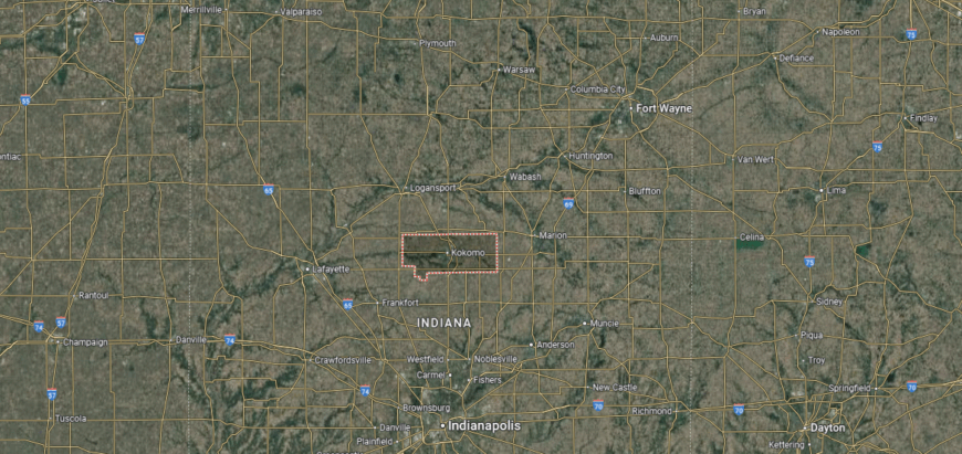
Howard County is positioned in north-central Indiana. The county seat, Kokomo, is about 50 miles north of Indianapolis and roughly 60 miles south of South Bend. It sits around 20 miles west of Marion.
U.S. Route 31 runs north–south through Kokomo, connecting the county to major cities and regional highways. State Roads 22 and 26 offer additional east–west access, while the surrounding flat terrain is primarily agricultural with urban development centered in and around Kokomo.
#21. Elkhart County, Indiana
– Overall Rank: 642
– Population: 206,841
– Median household income: $63,978
– Median home value: $181,800 (71% own)
– Median rent: $945 (29% rent)
– Top public schools: Wakarusa Elementary School (grade A), North Wood Middle School (grade A), Woodview Elementary School (grade A)
– Top private schools: Bethany Christian Schools (grade A minus), Elkhart Christian Academy (grade B+), Clinton Christian School (grade C+)
– Top places: Nappanee (grade A minus), Goshen (grade A minus), Dunlap (grade B+)
You may also like: These 10 car insurers have the highest market share in Indiana
About
Elkhart County stands out as a national leader in RV manufacturing, with a strong network of suppliers and skilled trades that fuel its reputation as the “RV Capital of the World.” Agriculture also plays a central role, with fertile farmland supporting crop production and agribusiness.
Its location near the Michigan border provides valuable transportation access for both domestic and international markets. Beyond its industrial strength, the county is known for a vibrant blend of cultural influences, including Amish heritage, arts festivals, and community fairs.
Scenic backroads, parks, and nature areas invite exploration, while local markets and events showcase regional craftsmanship. With a mix of tradition, innovation, and community pride, Elkhart County offers both economic vitality and a distinctive cultural character.
Where is Elkhart County?

Elkhart County is located in northern Indiana, along the Michigan state line. The county seat, Goshen, lies about 25 miles southeast of South Bend and roughly 100 miles east of Chicago, Illinois. The city of Elkhart, another major population center, is situated near the St. Joseph and Elkhart rivers.
The county is crossed by U.S. Route 33 and the Indiana Toll Road (I-80/I-90), providing direct links to regional and interstate destinations. Its position near the state border offers easy access to both northern Indiana communities and southwestern Michigan.
#20. Posey County, Indiana
– Overall Rank: 566
– Population: 25,226
– Median household income: $75,594
– Median home value: $200,900 (81% own)
– Median rent: $735 (19% rent)
– Top public schools: South Terrace Elementary School (grade A), Marrs Elementary School (grade A minus), North Posey Junior High School (grade A minus)
– Top private schools: St. Wendel School (grade unavailable), St. Philip School (grade unavailable), St. Matthew Elementary School (grade unavailable)
– Top places: Mount Vernon (grade B), Bethel Township (grade A+), Marrs Township (grade A minus)
About
Posey County sits at Indiana’s southwestern tip, bordered by both the Ohio and Wabash Rivers, giving it a unique position for trade, transportation, and outdoor recreation. Agriculture remains a foundation of the local economy, complemented by manufacturing, logistics, and small business growth.
Its riverfront location also supports commerce and connects the county to regional markets across state lines. Cultural life reflects a deep connection to history and the outdoors, with heritage festivals, local arts, and community gatherings throughout the year.
Residents enjoy boating, fishing, and exploring nature preserves along the rivers, as well as a network of parks and trails. With close-knit communities, quality schools, and active civic involvement, Posey County offers a blend of rural charm and strategic economic opportunity.
Where is Posey County?
Posey County sits in the southwestern tip of Indiana, where the Ohio and Wabash rivers meet. The county seat, Mount Vernon, is located about 20 miles west of Evansville and roughly 175 miles southwest of Indianapolis. It borders both Illinois to the west and Kentucky to the south.
U.S. Route 62 and State Road 69 run through the county, offering connections to nearby cities and river crossings. The landscape is shaped by its riverfront position, with fertile bottomlands and transportation routes tied closely to the waterways.
#19. Kosciusko County, Indiana
– Overall Rank: 462
– Population: 80,442
– Median household income: $70,945
– Median home value: $183,300 (76% own)
– Median rent: $946 (24% rent)
– Top public schools: Lincoln Elementary School (grade A), Edgewood Middle School (grade A), Eisenhower Elementary School (grade A minus)
– Top private schools: Lakeland Christian Academy (grade B+), Sacred Heart Elementary School (grade unavailable), Pierceton Woods Academy (grade unavailable)
– Top places: Winona Lake (grade A+), Warsaw (grade A), Syracuse (grade B+)
About
Kosciusko County is known for its thriving orthopedic industry, which has earned it recognition as a global hub for medical device manufacturing. A diverse economy also includes agriculture, tourism, and small business enterprises, supported by steady infrastructure investment and workforce development programs.
The county’s numerous lakes and central northern Indiana location make it both an economic and recreational draw. Life here is shaped by a strong outdoor culture, with boating, fishing, and lakeside events central to community life.
Annual festivals, farmers markets, and arts programs add to the area’s vibrant local character. Combined with quality schools, active volunteer networks, and engaged neighborhoods, Kosciusko County offers a setting where innovation, natural beauty, and community spirit intersect.
Where is Kosciusko County?

🔥 Would you like to save this?
Kosciusko County is situated in north-central Indiana, known for its numerous natural lakes. The county seat, Warsaw, lies about 40 miles northwest of Fort Wayne and roughly 120 miles north of Indianapolis. It is positioned around 50 miles southeast of South Bend.
U.S. Route 30 runs east–west through the county, while State Roads 15 and 25 provide north–south connections. The abundance of lakes, including Lake Wawasee and Winona Lake, shapes both the local geography and recreational opportunities.
#18. Delaware County, Indiana
– Overall Rank: 450
– Population: 112,156
– Median household income: $53,377
– Median home value: $120,500 (66% own)
– Median rent: $841 (34% rent)
– Top public schools: Indiana Academy for Science, Mathematics, and Humanities (grade A+), Yorktown High School (grade A), Delta High School (grade A)
– Top private schools: Heritage Hall Christian School (grade B minus), St. Michael Catholic School (grade unavailable), Huffer Memorial Children’s Center (grade unavailable)
– Top places: Yorktown (grade A), Muncie (grade B), Daleville (grade B)
About
Delaware County pairs its rich manufacturing roots with the energy of a university-centered community. Ball State University anchors the local economy, driving innovation, research, and cultural engagement, while healthcare, logistics, and advanced manufacturing round out a well-balanced economic profile.
Strategic investment in business districts and public infrastructure continues to position the county for long-term growth. The arts play a prominent role, with galleries, live music, and theater complementing seasonal festivals and neighborhood gatherings.
Green spaces, riverfront trails, and sports facilities offer residents ways to stay active and connected. Blending educational influence with hometown pride, Delaware County fosters an environment where progress and tradition move forward together.
Where is Delaware County?

Delaware County is located in east-central Indiana. The county seat, Muncie, sits about 60 miles northeast of Indianapolis and roughly 65 miles southwest of Fort Wayne. It lies approximately 20 miles west of the Indiana–Ohio state line.
U.S. Route 35 and State Road 67 pass through Muncie, offering direct access to regional cities and rural areas. The White River flows through the county, influencing both its landscape and transportation corridors.
#17. Hancock County, Indiana
– Overall Rank: 424
– Population: 80,170
– Median household income: $85,262
– Median home value: $235,500 (80% own)
– Median rent: $1,058 (20% rent)
– Top public schools: New Palestine Intermediate School (grade A), New Palestine Junior High (grade A), Brandywine Elementary School (grade A minus)
– Top private schools: Zion Lutheran School (grade unavailable), St. Michael’s Catholic School (grade unavailable)
– Top places: McCordsville (grade A+), New Palestine (grade B+), Greenfield (grade B+)
About
Hancock County blends its agricultural heritage with a steadily expanding role as a residential and business hub in central Indiana. Logistics centers, light manufacturing, and small enterprises thrive alongside family farms, creating a balanced and resilient economy.
Its location just east of Indianapolis gives residents the advantages of metropolitan access while maintaining a distinct local identity. Community life features a mix of long-standing traditions and new opportunities, from annual harvest celebrations to modern recreational facilities.
Trails, green spaces, and sports programs keep outdoor life active, while local events strengthen neighborhood ties. With thoughtful growth planning and strong public services, Hancock County continues to evolve without losing the close-knit spirit that defines it.
Where is Hancock County?
Hancock County is positioned in central Indiana, just east of Indianapolis. The county seat, Greenfield, lies about 20 miles from downtown Indianapolis and roughly 90 miles west of Dayton, Ohio. It is located along the I-70 corridor, providing quick access to major metropolitan areas.
U.S. Route 40 runs parallel to Interstate 70 through the county, while State Road 9 connects Greenfield to communities north and south. The county’s landscape is largely agricultural, with suburban growth extending outward from the Indianapolis metro area.
#16. Lake County, Indiana
– Overall Rank: 344
– Population: 497,682
– Median household income: $66,375
– Median home value: $195,100 (71% own)
– Median rent: $1,039 (29% rent)
– Top public schools: Munster High School (grade A+), Wilbur Wright Middle School (grade A+), Frank H. Hammond Elementary School (grade A)
– Top private schools: Andrean High School (grade A), Bishop Noll Institute (grade A), Illiana Christian High School (grade B+)
– Top places: Munster (grade A+), Dyer (grade A), St. John (grade A)
You may also like: Best places to live in Indiana
About
Lake County serves as a gateway between Indiana and the Chicago metropolitan area, giving it a unique advantage for commerce, industry, and cultural exchange. A long-standing manufacturing tradition is now paired with growth in healthcare, logistics, and entrepreneurial ventures, creating a broad and adaptable economy.
Its position along Lake Michigan also supports shipping, tourism, and waterfront development. The county’s character reflects both urban vibrancy and neighborhood-focused living, with festivals, markets, and arts events drawing diverse communities together.
Lakefront trails, marinas, and nature areas provide space for recreation and relaxation. Combining economic reach with a strong local identity, Lake County continues to evolve as a place where industry, culture, and community meet.
Where is Lake County?
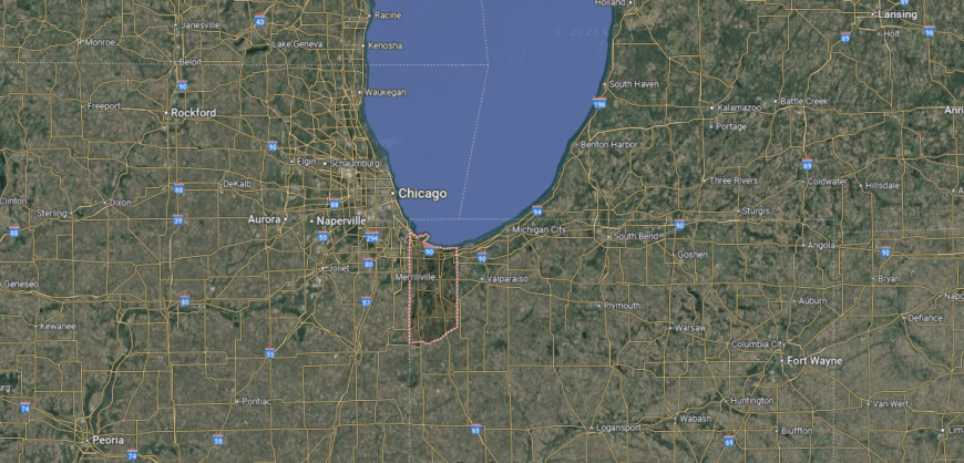
Lake County is located in the northwestern corner of Indiana, along the southern shore of Lake Michigan. The county seat, Crown Point, sits about 25 miles southeast of Chicago, Illinois, and roughly 15 miles south of the lakefront city of Gary. It shares its western border with Illinois.
Interstate 80/94, Interstate 65, and U.S. Route 41 cross through the county, creating major transportation links between Indiana, Illinois, and beyond. Its proximity to Chicago and Lake Michigan heavily influences the region’s economy, commuting patterns, and recreational access.
#15. Dubois County, Indiana
– Overall Rank: 308
– Population: 43,584
– Median household income: $68,945
– Median home value: $187,000 (77% own)
– Median rent: $771 (23% rent)
– Top public schools: Ireland Elementary School (grade A), Pine Ridge Elementary School (grade A), Ferdinand Elementary School (grade A)
– Top private schools: Precious Blood School (grade unavailable), Holy Family School (grade unavailable), Jasper Christian Academy (grade unavailable)
– Top places: Jasper (grade A), Huntingburg (grade A minus), Patoka Township (grade A minus)

About
Dubois County blends a reputation for craftsmanship with a diverse and steadily evolving economy. Furniture manufacturing and wood products remain central, supported by advanced manufacturing, agriculture, and local entrepreneurship.
Positioned in southern Indiana, the county benefits from strong transportation links that connect it to broader regional and national markets. Its cultural identity is deeply tied to German heritage, celebrated through annual festivals, music, and community gatherings.
Outdoor recreation ranges from scenic parklands to well-maintained trails, offering residents a variety of ways to enjoy the landscape. With engaged neighborhoods, respected schools, and an emphasis on preserving both heritage and growth, Dubois County maintains a balance between tradition and forward momentum.
Where is Dubois County?

Dubois County is situated in southern Indiana, within the rolling hills of the Hoosier State’s interior. The county seat, Jasper, lies about 60 miles west of Louisville, Kentucky, and roughly 85 miles east of Evansville. It is positioned around 30 miles south of Bedford.
U.S. Route 231 and State Road 56 run through the county, linking it to nearby towns and regional hubs. The area’s terrain is a mix of forested land, farmland, and small waterways, shaping both its travel routes and local character.
#14. Vanderburgh County, Indiana
– Overall Rank: 305
– Population: 179,900
– Median household income: $58,839
– Median home value: $162,800 (65% own)
– Median rent: $930 (35% rent)
– Top public schools: Signature School (grade A+), North High School (grade A minus), McCutchanville Elementary School (grade A minus)
– Top private schools: Evansville Day School (grade A), Reitz Memorial High School (grade A minus), Mater Dei High School (grade B+)
– Top places: Melody Hill (grade A), Evansville (grade B+), Highland (grade B+)
🔥 Would you like to save this?
About
Vanderburgh County thrives as a regional anchor where industry, culture, and community intersect. Centered around Evansville, it draws strength from a mix of healthcare, manufacturing, education, and retail, all supported by a skilled workforce and strong infrastructure.
The Ohio River adds both scenic beauty and practical value, serving as a vital route for trade and connection. Daily life here blends urban energy with neighborly warmth—locals gather for riverfront concerts, cheer at sporting events, and stroll through farmers markets.
Historic neighborhoods stand beside revitalized districts, showing how tradition and progress can share the same streets. With opportunities for work, recreation, and connection, Vanderburgh County offers more than a place to live—it offers a place to belong.
Where is Vanderburgh County?
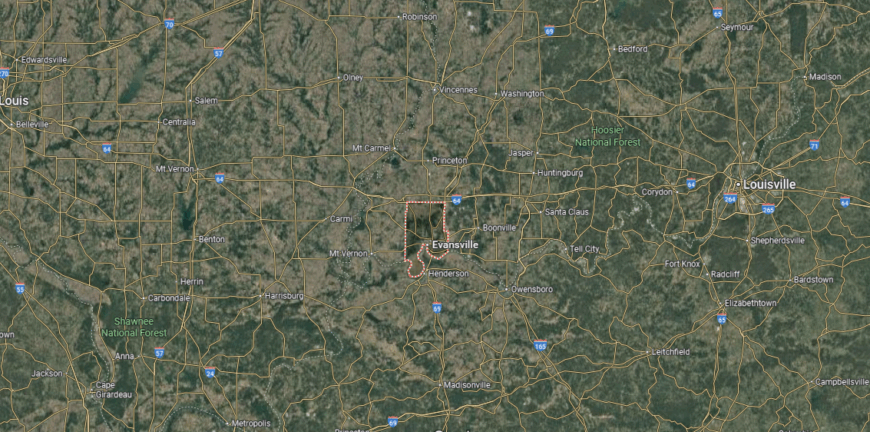
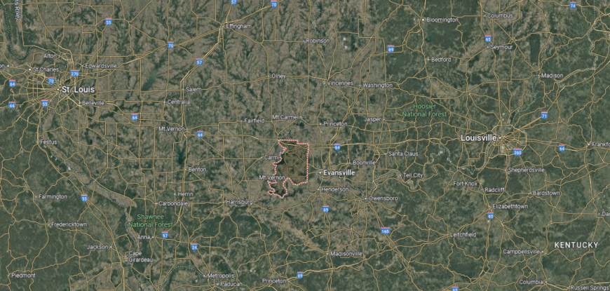
Vanderburgh County occupies a southwestern point of Indiana, where the Ohio River curves along its southern edge. Evansville, the county seat, is positioned across the river from Henderson, Kentucky, about 170 miles from Indianapolis and 120 miles from Louisville. Its location places it near the meeting point of Indiana, Kentucky, and Illinois.
The county is linked by Interstate 69, U.S. Route 41, and State Road 62, giving it strong connections to surrounding states and cities. River access plays a key role in the area’s transportation network, with the Ohio River serving as both a boundary and a shipping route.
#13. Johnson County, Indiana
– Overall Rank: 239
– Population: 161,952
– Median household income: $82,730
– Median home value: $240,700 (74% own)
– Median rent: $1,155 (26% rent)
– Top public schools: Center Grove Middle School Central (grade A), Maple Grove Elementary School (grade A), Center Grove Elementary School (grade A)
– Top private schools: Greenwood Christian Academy (grade B+), Ss. Francis & Clare Catholic School (grade unavailable), Our Lady of Greenwood School (grade unavailable)
– Top places: Bargersville (grade A), Greenwood (grade A minus), New Whiteland (grade A minus)

About
Johnson County sits just south of Indianapolis, blending the convenience of city access with a strong sense of its own identity. Its economy reflects both tradition and adaptation—agriculture and manufacturing remain important, while healthcare, education, and small enterprises continue to expand.
Steady population growth has encouraged investment in infrastructure, housing, and community amenities. On weekends, residents might explore farmers markets, attend local art shows, or gather for seasonal parades and festivals.
Trails and parks weave through towns and countryside, offering places to walk, cycle, and connect with nature. Johnson County’s mix of opportunity, heritage, and everyday livability makes it a place where people put down roots and build lasting connections.
Where is Johnson County?
Johnson County lies in central Indiana, directly south of Indianapolis. The county seat, Franklin, is located about 20 miles from downtown Indianapolis and roughly 90 miles north of Louisville, Kentucky. It sits along a major growth corridor extending from the state capital.
Interstate 65 runs north–south through the county, while U.S. Route 31 and State Road 44 provide additional connections to neighboring communities. A mix of suburban neighborhoods, farmland, and small towns defines the county’s layout and travel routes.
#12. Porter County, Indiana
– Overall Rank: 236
– Population: 173,355
– Median household income: $82,915
– Median home value: $242,300 (77% own)
– Median rent: $1,092 (23% rent)
– Top public schools: Heavilin Elementary School (grade A), Ben Franklin Middle School (grade A), Thomas Jefferson Middle School (grade A)
– Top private schools: Victory Christian Academy (grade B+), Portage Christian School (grade B+), Immanuel Lutheran School (grade A)
– Top places: Chesterton (grade A), Valparaiso (grade A), Ogden Dunes (grade A)

About
Porter County offers a mix of economic diversity, natural beauty, and community vitality along the southern shore of Lake Michigan. Manufacturing, healthcare, education, and tourism all play key roles in its economy, supported by strong transportation links and proximity to the Chicago metropolitan area.
The Indiana Dunes provide both a natural landmark and a driver for recreation and visitor activity. Life here moves between bustling town centers and the quiet rhythm of beaches, trails, and wooded preserves.
Festivals, farmers markets, and arts events bring residents together, while historic districts preserve a sense of place. With quality schools, active civic organizations, and access to both nature and city life, Porter County offers a balance that appeals to a wide range of lifestyles.
Where is Porter County?
Porter County is positioned in northwestern Indiana, along the southern shore of Lake Michigan. The county seat, Valparaiso, sits about 50 miles southeast of Chicago, Illinois, and roughly 10 miles south of the Indiana Dunes National Park. It lies between LaPorte County to the east and Lake County to the west.
Interstate 94, U.S. Route 20, and State Road 49 cross the county, linking lakefront areas to inland towns and regional hubs. Proximity to Lake Michigan and the Indiana Dunes shapes both the county’s transportation network and its recreational access.
#11. Marion County, Indiana
– Overall Rank: 219
– Population: 971,737
– Median household income: $59,504
– Median home value: $184,100 (55% own)
– Median rent: $1,042 (45% rent)
– Top public schools: Herron High School (grade A+), Arthur C. Newby Elementary School (grade A), Speedway Senior High School (grade A)
– Top private schools: International School of Indiana (grade A+), Park Tudor School (grade A+), Brebeuf Jesuit Preparatory School (grade A+)
– Top places: Devon (grade A+), North Central (grade A+), Delaware Trails (grade A+)
You may also like: Where refugees in Indiana are arriving from
About
Marion County serves as the economic, cultural, and political center of Indiana, anchored by the city of Indianapolis. Its economy spans government, healthcare, education, manufacturing, logistics, and a growing tech sector, all supported by a well-developed transportation network.
As the state’s most populous county, it attracts both major employers and entrepreneurial ventures, driving steady growth and innovation. Cultural life is as varied as its communities—professional sports, world-class museums, performing arts, and diverse festivals fill the calendar year-round.
Greenways, parks, and riverfront trails provide outdoor escapes within an urban setting, while historic neighborhoods offer a glimpse into the city’s past. With its blend of big-city opportunity and neighborhood-level connection, Marion County continues to shape Indiana’s future while honoring its roots.
Where is Marion County?

Marion County sits in the center of Indiana and contains the state capital, Indianapolis. The city is located about 110 miles southeast of Chicago, Illinois, and roughly 100 miles northwest of Louisville, Kentucky. It is bordered by several central Indiana counties, forming the core of the Indianapolis metropolitan area.
Interstate highways 65, 69, 70, and 74 converge in Marion County, making it a major transportation hub. U.S. Routes and state roads further connect urban neighborhoods with surrounding suburbs, while the White River flows through the heart of Indianapolis.
#10. Warrick County, Indiana
– Overall Rank: 153
– Population: 64,065
– Median household income: $91,105
– Median home value: $215,600 (82% own)
– Median rent: $964 (18% rent)
– Top public schools: Lynnville Elementary School (grade A), Castle High School (grade A), Sharon Elementary School (grade A)
– Top private schools: Newburgh Christian Academy (grade B+), St. John the Baptist School (grade unavailable)
– Top places: Newburgh (grade A minus), Boonville (grade A minus), Chandler (grade B+)
About
Warrick County sits along the Ohio River, where expanding neighborhoods meet open farmland and historic small towns. Its economy draws strength from manufacturing, healthcare, energy production, and a growing retail sector, with Evansville nearby providing additional opportunities for work and commerce.
Well-placed highways and river access make it a natural link in the region’s transportation network. Life here has a rhythm that blends activity and connection—residents gather at local festivals, explore parks and lakes, or spend weekends on hiking and biking trails.
Community pride shows in well-kept neighborhoods, volunteer projects, and school events that bring people together. In Warrick County, growth comes with a commitment to preserving the character and connections that define the area.
Where is Warrick County?
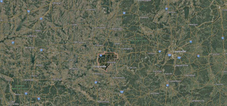
Warrick County is located in southwestern Indiana, just east of Evansville. The county seat, Boonville, lies about 15 miles from downtown Evansville and roughly 160 miles southwest of Indianapolis. The Ohio River forms part of its southern boundary, opposite Kentucky.
Key routes such as State Road 62 and State Road 66 run through the county, linking riverfront areas to inland communities. Its position along the Ohio River and proximity to Evansville influence both local commerce and regional travel.
#9. Floyd County, Indiana
– Overall Rank: 149
– Population: 80,191
– Median household income: $75,686
– Median home value: $214,800 (74% own)
– Median rent: $943 (26% rent)
– Top public schools: Floyds Knobs Elementary School (grade A), Greenville Elementary School (grade A), Highland Hills Middle School (grade A)
– Top private schools: Christian Academy of Indiana (grade B+), Our Lady of Perpetual Help School (grade unavailable), St. Mary of the Knobs Catholic School (grade unavailable)
– Top places: Georgetown (grade A minus), New Albany (grade A minus), Galena (grade B+)
About
Floyd County offers a mix of riverfront energy, small-town charm, and access to metropolitan opportunities. Anchored by its position along the Ohio River, the area supports a diverse economy that includes healthcare, manufacturing, education, and a variety of local enterprises.
Its close proximity to Louisville provides both cultural exchange and expanded employment options while keeping a strong local identity intact. The county’s rhythm is shaped by community traditions, from seasonal fairs and music gatherings to neighborhood markets and historical tours.
Parks, greenways, and scenic overlooks encourage time outdoors, whether for quiet walks or active recreation. In Floyd County, growth and heritage coexist, creating a setting where progress feels rooted in a shared story.
Where is Floyd County?
Floyd County lies in the far southern part of Indiana, along the Ohio River. The county seat, New Albany, sits directly across from Louisville, Kentucky, and is about 110 miles south of Indianapolis. It is bordered to the east by Clark County and to the west by Harrison County.
Interstate 64 passes through New Albany, providing quick access to Louisville and points west. State roads connect smaller towns and rural areas, while the Ohio River shapes much of the county’s southern edge and transportation links.
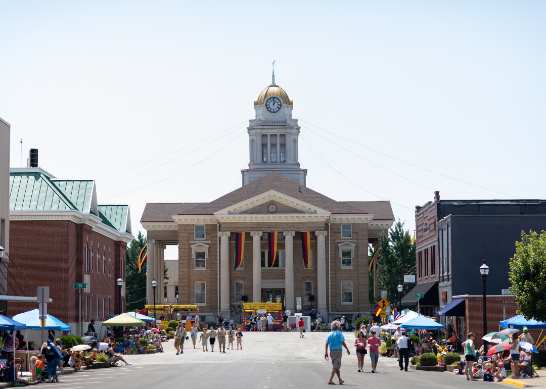
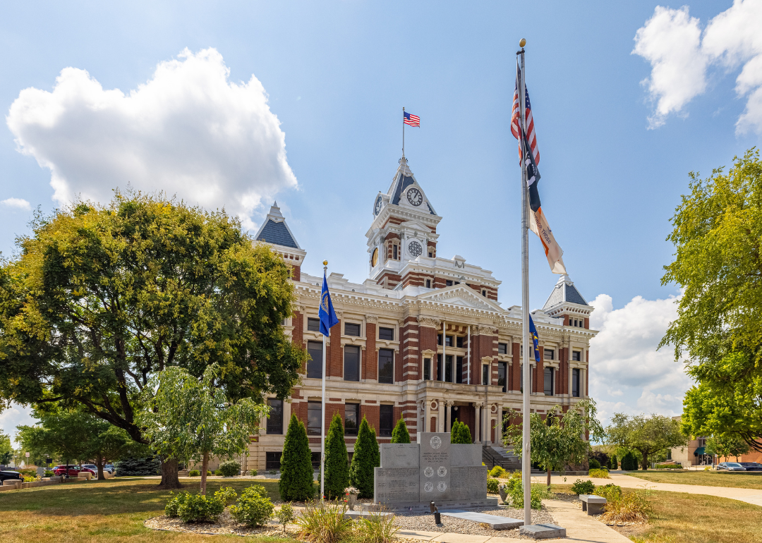
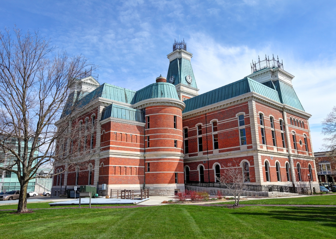
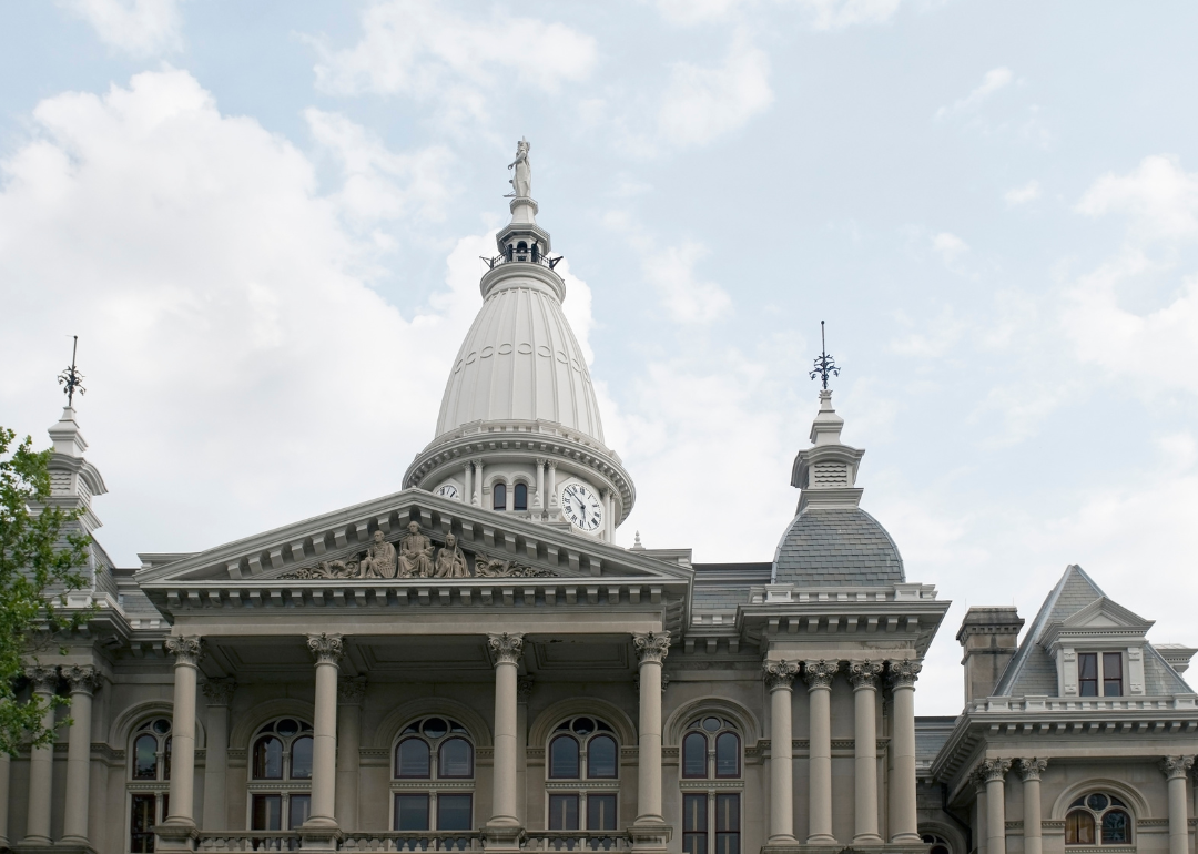
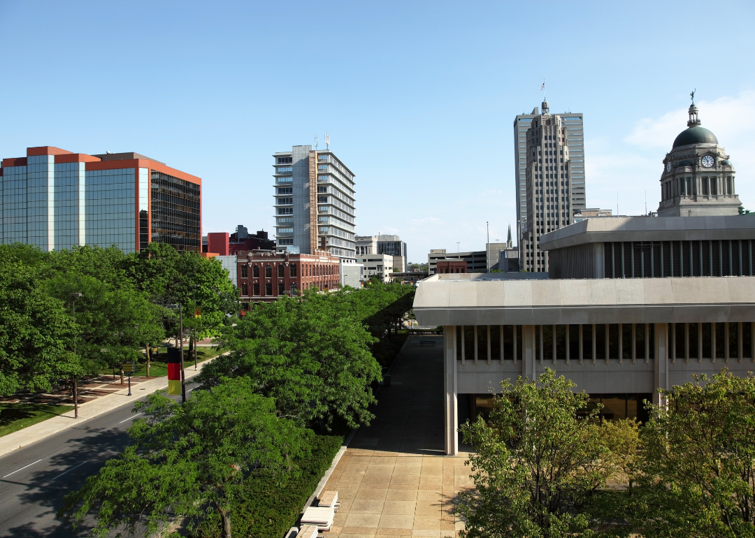
#8. Bartholomew County, Indiana
– Overall Rank: 148
– Population: 82,371
– Median household income: $76,912
– Median home value: $197,500 (70% own)
– Median rent: $1,063 (30% rent)
– Top public schools: Southside Elementary School (grade A), Columbus North High School (grade A), Columbus Signature Academy (CSA) – Lincoln Campus (grade A minus)
– Top private schools: Columbus Christian School (grade B), St. Peter’s Lutheran School (grade unavailable), St. Bartholomew Catholic School (grade unavailable)
– Top places: Columbus (grade A), Harrison Township (grade A), German Township (grade A minus)
About
Bartholomew County stands out in Indiana for its unusual blend of industrial strength and creative spirit. While manufacturing—especially in automotive and engine production—remains a cornerstone, the local economy also thrives on healthcare, education, and entrepreneurial ventures.
Its position along major transportation routes keeps the county well connected to regional and national markets. What truly sets Bartholomew County apart is its reputation for world-class architecture and public art, visible in civic buildings, parks, and community spaces.
Residents take part in festivals, concerts, and cultural programs that reflect both global influences and local traditions. Here, economic opportunity and artistic vision work side by side, shaping a community that values both productivity and inspiration.
Where is Bartholomew County?
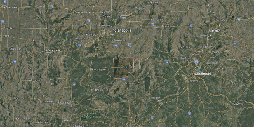
Bartholomew County sits in south-central Indiana, with Columbus as its county seat. Columbus is positioned about 45 miles from Indianapolis and around 60 miles from Louisville, placing it along a key travel corridor between the two cities. The county is bordered by Johnson County to the north and Jackson County to the south.
Major routes include Interstate 65, which runs north–south through the county, and U.S. Route 31, providing an alternate parallel route. State Road 46 links east–west destinations, while the meeting point of the Flatrock and Driftwood rivers near Columbus adds a distinctive feature to the local geography.
#7. Tippecanoe County, Indiana
– Overall Rank: 129
– Population: 186,955
– Median household income: $55,728
– Median home value: $199,300 (53% own)
– Median rent: $1,020 (47% rent)
– Top public schools: West Lafayette Junior/Senior High School (grade A+), West Lafayette Intermediate School (grade A+), West Lafayette Elementary School (grade A+)
– Top private schools: Central Catholic Jr. – Sr. High School (grade A), Faith Christian School (grade B+), St. James Lutheran Elementary School (grade A)
– Top places: West Lafayette (grade A+), Battle Ground (grade A), Lafayette (grade A minus)
About
Tippecanoe County is shaped by a dynamic mix of academic influence, industry, and natural resources. Purdue University serves as both an educational powerhouse and an economic engine, driving research, innovation, and workforce development.
Surrounding the campus, a network of businesses—from manufacturing and healthcare to tech startups—contributes to a well-rounded and resilient economy. The Wabash River winds through the county, offering scenic spaces for boating, cycling, and waterfront events.
Farmers markets, music festivals, and historic districts give each community its own personality while keeping a shared sense of place. In Tippecanoe County, tradition and forward thinking meet in a way that supports both progress and quality of life.
Where is Tippecanoe County?

Tippecanoe County lies in west-central Indiana along the Wabash River. Its county seat, Lafayette, is positioned about 65 miles from Indianapolis and roughly 125 miles from Chicago, with West Lafayette directly across the river. The county is bordered by Benton County to the northwest and Clinton County to the southeast.
Travel is supported by Interstate 65 running along its eastern edge, while U.S. Routes 52 and 231 cut through both urban and rural areas. The river and the presence of Purdue University create a blend of academic, residential, and commercial activity that shapes the county’s connections.
#6. Allen County, Indiana
– Overall Rank: 118
– Population: 385,456
– Median household income: $66,222
– Median home value: $173,600 (69% own)
– Median rent: $924 (31% rent)
– Top public schools: Arcola School (grade A), East Allen University (grade A), Aboite Elementary School (grade A)
– Top private schools: Canterbury School (grade A+), Bishop Luers High School (grade A), Concordia Lutheran High School (grade A minus)
– Top places: Huntertown (grade A), Leo-Cedarville (grade A minus), Fort Wayne (grade A minus)
You may also like: Best suburbs to live in Indiana

About
Allen County blends urban vitality with regional reach, serving as a gateway to northeastern Indiana’s economy and culture. Fort Wayne drives much of the activity, hosting industries from advanced manufacturing and healthcare to defense and emerging tech ventures.
Its position at the intersection of major highways, rail corridors, and air routes makes it a natural center for commerce and logistics. Beyond its economic role, the county offers a rich mix of experiences—historic neighborhoods alongside modern riverfront projects, seasonal festivals, and a growing arts scene.
Greenways and parks link communities, providing spaces for cycling, walking, and gathering. Allen County’s identity comes from this balance of progress, connectivity, and a strong sense of place.
Where is Allen County?
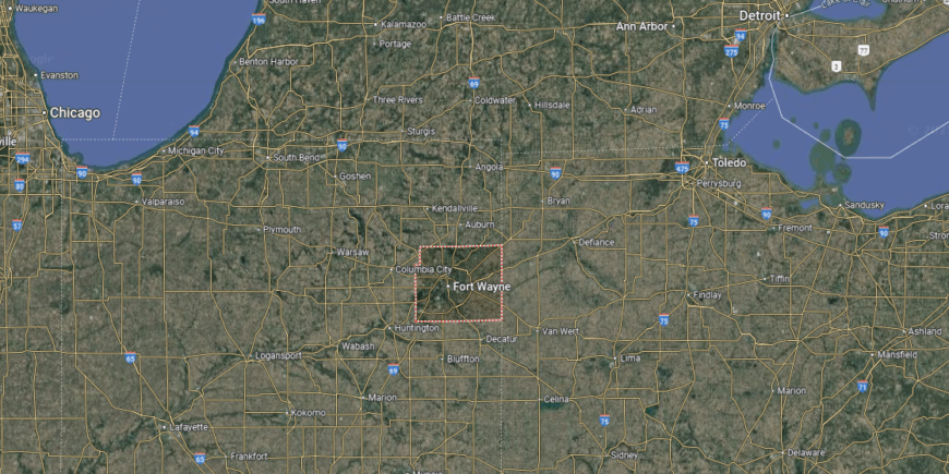
Allen County occupies Indiana’s northeastern corner, sharing its eastern border with Ohio. Fort Wayne, the county seat, lies about 120 miles from Indianapolis and roughly 20 miles from the state line, serving as a regional hub for commerce and transportation. The Maumee, St. Joseph, and St. Marys rivers all converge within the city.
Transportation is anchored by Interstates 69 and 469, which link the county to other parts of Indiana and neighboring states. Multiple U.S. highways, including 24, 27, 30, and 33, create a network of routes radiating outward from Fort Wayne.
#5. St. Joseph County, Indiana
– Overall Rank: 106
– Population: 272,388
– Median household income: $61,877
– Median home value: $165,700 (68% own)
– Median rent: $969 (32% rent)
– Top public schools: Northpoint Elementary School (grade A), Discovery Middle School (grade A), Prairie Vista Elementary School (grade A)
– Top private schools: Trinity School at Greenlawn (grade A+), Saint Joseph High School (grade A), Marian High School (grade A)
– Top places: Granger (grade A+), Osceola (grade A), Mishawaka (grade A minus)
About
St. Joseph County is a northern Indiana hub where education, industry, and cultural heritage converge. Anchored by the University of Notre Dame, the local economy benefits from research, healthcare, manufacturing, and a growing technology sector.
Its location along major transportation routes, including highway and rail, supports strong regional and national connections. The county’s character is enriched by a mix of historic architecture, collegiate traditions, and community events that draw visitors year-round.
Residents enjoy riverfront trails, parks, and seasonal festivals, as well as vibrant arts and music scenes. In St. Joseph County, academic excellence, economic opportunity, and a deep sense of community work together to create a place with both momentum and enduring charm.
Where is St. Joseph County?
St. Joseph County is located in northern Indiana along the Michigan state line. South Bend, the county seat, is about 90 miles east of Chicago, Illinois, and roughly 150 miles north of Indianapolis. The city of Mishawaka, a major neighboring community, lies just to the east of South Bend.
The county is crossed by the Indiana Toll Road (I-80/I-90), providing quick access to Chicago and points east. U.S. Routes 20 and 31, along with State Road 23, connect local cities and towns, while the St. Joseph River winds through the area and shapes its layout.
#4. Hendricks County, Indiana
– Overall Rank: 72
– Population: 175,639
– Median household income: $95,261
– Median home value: $257,700 (78% own)
– Median rent: $1,271 (22% rent)
– Top public schools: Brownsburg East Middle School (grade A+), Eagle Elementary School (grade A+), Reagan Elementary School (grade A+)
– Top private schools: Bethesda Christian Schools (grade B+), St. Malachy Catholic School (grade unavailable), St. Susanna School (grade unavailable)
– Top places: Brownsburg (grade A+), Pittsboro (grade A+), Avon (grade A)
About
Hendricks County pairs rapid growth with a strong sense of local identity, offering both suburban convenience and rural landscapes. Its economy is supported by healthcare, manufacturing, logistics, and a steadily expanding retail sector, aided by its location just west of Indianapolis.
Continued investment in infrastructure and community planning has helped balance development with quality-of-life priorities. The county’s social life revolves around farmers markets, seasonal festivals, and community fairs, alongside a growing network of parks and trails.
Historic town centers stand beside new neighborhoods, reflecting a blend of tradition and modern amenities. With engaged residents, strong schools, and a focus on livability, Hendricks County continues to attract people looking for opportunity and connection.
Where is Hendricks County?

Hendricks County sits just west of Indianapolis in central Indiana. Danville, the county seat, is about 20 miles from downtown Indianapolis and roughly 140 miles east of Terre Haute. The county is bordered by Boone County to the north and Morgan County to the south.
Interstate 70 runs along its southern edge, while U.S. Route 36 passes through the center, linking small towns to the state capital. State Road 267 and other local routes connect suburban neighborhoods, farmland, and growing commercial areas throughout the county.
#3. Boone County, Indiana
– Overall Rank: 38
– Population: 71,235
– Median household income: $103,038
– Median home value: $320,000 (80% own)
– Median rent: $1,190 (20% rent)
– Top public schools: Zionsville Community High School (grade A+), Boone Meadow (grade A+), Zionsville Pleasant View Elementary School (grade A+)
– Top private schools: Traders Point Christian Schools (grade A minus), James E. Davis School (grade B), Children’s Learning Program (grade unavailable)
– Top places: Zionsville (grade A+), Whitestown (grade A), Lebanon (grade B+)

About
Boone County combines a strong agricultural tradition with one of the fastest-growing business corridors in central Indiana. Its economy benefits from logistics hubs, advanced manufacturing, healthcare, and a steadily expanding retail and service sector.
Located between Indianapolis and Lafayette, the county enjoys strategic transportation access that fuels both local enterprise and regional trade. Community life is marked by a mix of small-town gatherings, county fairs, and new developments that bring modern amenities to historic settings.
Trails, parks, and recreational facilities offer year-round opportunities for outdoor activity. With thoughtful growth planning, quality schools, and active civic engagement, Boone County balances economic momentum with a welcoming, close-knit atmosphere.
Where is Boone County?
Boone County occupies a spot in central Indiana between Indianapolis and the agricultural regions to the north. The county seat, Lebanon, rests along the route from the state capital to Lafayette, placing it roughly 30 miles from Indianapolis. Its boundaries connect it with Hendricks County to the south and Clinton County to the north.
Rather than running straight, Interstate 65 cuts diagonally across Boone County, linking it to both urban centers and outlying rural areas. Smaller highways and state roads weave through farmland and small towns, forming a network that supports both local and regional travel.
#2. Monroe County, Indiana
– Overall Rank: 22
– Population: 140,065
– Median household income: $60,308
– Median home value: $240,600 (55% own)
– Median rent: $1,105 (45% rent)
– Top public schools: The Academy of Science and Entrepreneurship (grade A+), Bloomington High School South (grade A), Childs Elementary School (grade A)
– Top private schools: Lighthouse Christian Academy (grade A), Harmony School (grade A minus), Clear Creek Christian School (grade A+)
– Top places: Bloomington (grade A), Ellettsville (grade A), Perry Township (grade A+)
About
Monroe County thrives as a cultural and educational hub in south-central Indiana, anchored by Indiana University’s presence in Bloomington. The university fuels research, arts, and innovation, while the local economy also draws strength from healthcare, manufacturing, technology, and small business ventures.
Its location near major highways allows easy access to larger markets while maintaining a distinct local identity. Life here blends academic energy with a rich arts and music scene, from gallery walks and theater performances to live concerts and film festivals.
Outdoor recreation is abundant, with nearby forests, lakes, and trails offering a natural balance to the vibrant downtown. In Monroe County, education, creativity, and community spirit converge to create a setting that is both dynamic and deeply rooted.
Where is Monroe County?
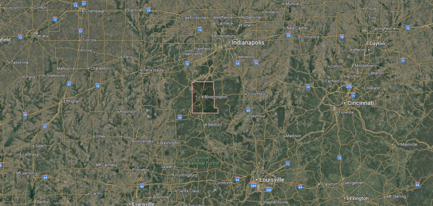
Monroe County is set in south-central Indiana, with Bloomington as both its county seat and home to Indiana University’s main campus. Bloomington lies about 50 miles southwest of Indianapolis and roughly 90 miles north of Louisville, Kentucky. The county is bordered by Morgan County to the northeast and Lawrence County to the south.
State Road 37, part of the future Interstate 69 corridor, runs north–south through Monroe County, while State Roads 46 and 48 provide key east–west connections. The presence of rolling hills, forests, and nearby Lake Monroe shapes the county’s travel routes and landscape.
#1. Hamilton County, Indiana
– Overall Rank: 5
– Population: 349,527
– Median household income: $114,866
– Median home value: $350,900 (76% own)
– Median rent: $1,412 (24% rent)
– Top public schools: Carmel High School (grade A+), Creekside Middle School (grade A+), West Clay Elementary School (grade A+)
– Top private schools: Eman Schools (grade A+), University High School of Indiana (grade A), St. Theodore Guerin High School (grade A)
– Top places: Carmel (grade A+), Fishers (grade A+), Westfield (grade A+)
About
Hamilton County is one of Indiana’s fastest-growing areas, known for its blend of economic opportunity, high quality of life, and well-planned communities. Its economy is anchored by healthcare, technology, finance, and professional services, with a strong small business presence adding to its diversity.
Proximity to Indianapolis enhances market access while allowing the county to maintain its own thriving civic and cultural identity. Neighborhoods here are linked by extensive trail systems, parks, and green spaces that encourage outdoor activity.
Concert venues, art districts, and seasonal festivals fill the calendar, reflecting a community invested in both culture and connection. With strong schools, modern infrastructure, and active local engagement, Hamilton County continues to attract residents seeking both growth and a sense of place.
Where is Hamilton County?
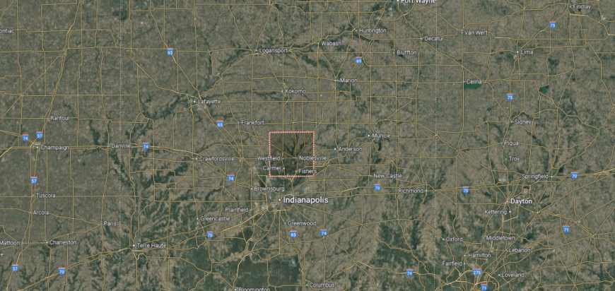
Hamilton County sits just north of Indianapolis in central Indiana. The county seat, Noblesville, is about 25 miles from downtown Indianapolis, with other major communities including Carmel, Fishers, and Westfield. Its boundaries connect it with Boone County to the west and Madison County to the east.
U.S. Route 31 and Interstate 69 serve as primary corridors, linking the county to the state capital and beyond. State Roads 32, 37, and 38 connect smaller towns, while suburban growth and developed road networks make Hamilton County a key part of the Indianapolis metropolitan area.
This story features data reporting and writing by Elena Cox and is part of a series utilizing data automation across 50 states.
You may also like: How gas prices have changed in Indiana in the last week
By Stacker


