🔥 Would you like to save this?
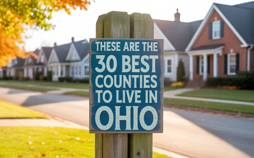
Best counties to live in Ohio based on a variety of data including median home prices for mortgage insights
More counties in the United States experienced population growth in the last year, according to the latest Census data, even as pandemic-related moving trends begin to normalize.
Counties in the South continued to experience growth, particularly in Florida, where 96% of its 67 counties gained new residents. Polk County, Florida, a suburb of Orlando, added the most, with 26,000 people moving there in 2023.
Meanwhile, counties in the Midwest and Northeast continued to lose population, but at slower rates than the year before. Some of the biggest losses were in counties home to large cities, including Cook County, Illinois (home of Chicago) and the boroughs of Brooklyn and Queens in New York.
Many counties are experiencing growth due to their job opportunities, education, or relatively affordable housing costs. Others are favored for their historic or well-designed downtowns or access to cultural opportunities.
Stacker compiled a list of the best counties to live in Ohio using rankings from Niche. Niche ranks counties by various factors including public schools, educational attainment, cost of living, and housing.
Keep reading to see if your county made the list.
You may also like: Ohio small businesses thrive in these counties
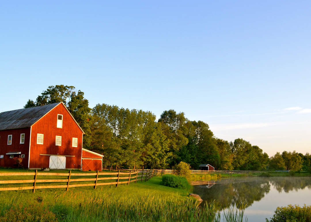
#30. Mercer County, Ohio
– Overall Rank: 933
– Population: 42,321
– Median household income: $73,278
– Median home value: $192,800 (79% own)
– Median rent: $749 (21% rent)
– Top public schools: Coldwater Middle School (grade A), Fort Recovery Middle School (grade A minus), St. Henry Elementary School (grade A minus)
– Top private schools: Immaculate Conception School (grade unavailable)
– Top places: Coldwater (grade A minus), Celina (grade B), St. Henry (grade A minus)
About
Mercer County, Ohio rests along the state’s western border, where flat farmland and open skies have long defined its character. The county seat of Celina sits on the shore of Grand Lake St. Marys, a landmark that shapes both recreation and local economy. Agriculture, small business, and manufacturing together sustain the rhythm of life across its towns and countryside.
In order to come up with the very specific design ideas, we create most designs with the assistance of state-of-the-art AI interior design software. Also, assume links that take you off the site are affiliate links such as links to Amazon. this means we may earn a commission if you buy something.
Residents gather at county fairs, festivals, and lakeside events that highlight tradition and strengthen social ties. Outdoor life thrives on the water, in parks, and across fields that connect people to the land. Mercer County reflects a steady balance of heritage, community pride, and the enduring presence of rural Ohio values.
Where is Mercer County?
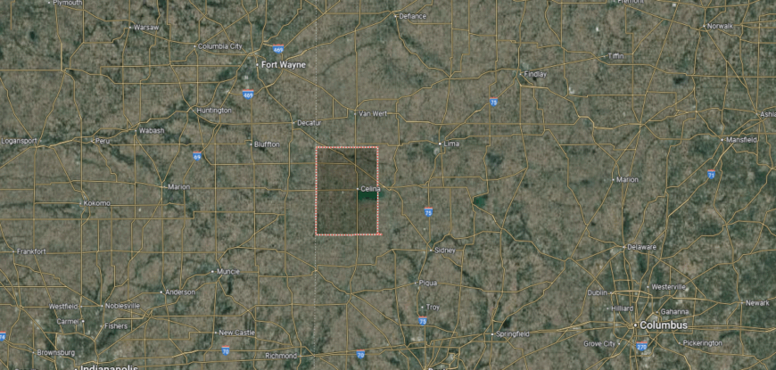
Mercer County sits along the western edge of Ohio, directly bordering the state of Indiana. It is surrounded by Auglaize County to the north, Darke County to the south, and Van Wert County to the northwest. The land stretches about 470 square miles, with flat to gently rolling terrain shaped by rich farmland and the shores of Grand Lake St. Marys.
Celina, the county seat, lies on the northern edge of the lake and serves as the commercial hub of the area. Coldwater, Fort Recovery, and St. Henry are among the county’s smaller towns, each with strong agricultural roots. Known for its blend of farming, manufacturing, and recreational opportunities on Grand Lake, Mercer County connects rural traditions with community-centered living.
#29. Defiance County, Ohio
– Overall Rank: 896
– Population: 38,300
– Median household income: $69,302
– Median home value: $147,600 (77% own)
– Median rent: $808 (23% rent)
– Top public schools: Ayersville Elementary School (grade A minus), Hicksville Elementary School (grade A minus), Tinora Elementary School (grade B+)
– Top private schools: Holy Cross Catholic School (grade unavailable), St. John Lutheran School (grade unavailable)
– Top places: Hicksville (grade B+), Defiance (grade B+), Richland Township (grade B+)
About
Defiance County, Ohio carries a history shaped by its rivers, forts, and early settlement at the edge of the Northwest Territory. The city of Defiance, the county seat, grew from its strategic position where the Maumee and Auglaize Rivers meet, preserving landmarks tied to frontier and military heritage. Surrounding towns and farmland continue the tradition of agriculture while supporting modern industry and commerce.
Life here is marked by community festivals, school-centered gatherings, and civic events that strengthen local pride. Parks, rivers, and trails offer residents opportunities for recreation and reflection on the region’s natural beauty. Defiance County stands as a place where history, resilience, and community connection remain at the heart of daily life.
Where is Defiance County?
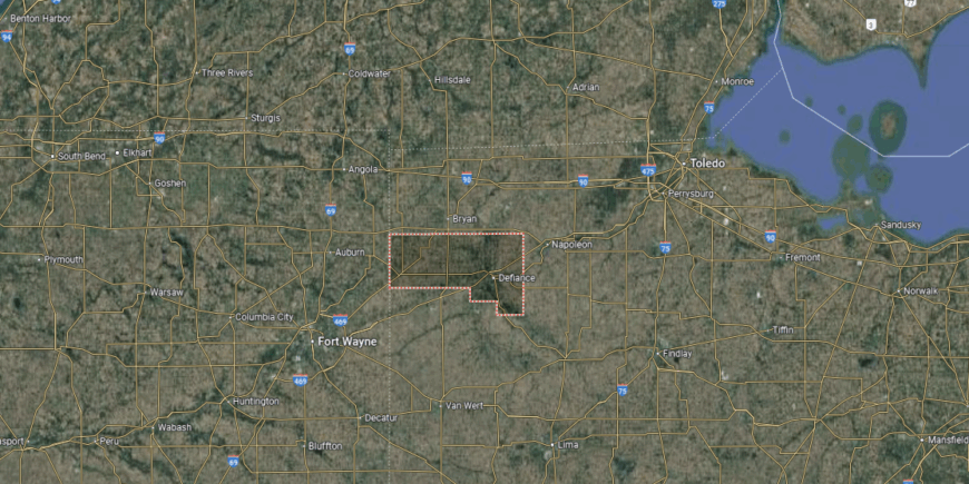
Defiance County is located in the northwestern part of Ohio, near the Indiana border. It is surrounded by Williams County to the north, Henry County to the east, and Paulding County to the west. The landscape spans about 415 square miles, with farmland, woodlands, and river valleys shaped by the Maumee and Auglaize rivers.
The city of Defiance, serving as the county seat, sits at the meeting point of the Maumee and Auglaize rivers. Other communities include Hicksville on the western edge and Sherwood to the south. Agriculture and manufacturing remain central to the county, giving it a balance of rural tradition and economic activity.
#28. Clermont County, Ohio
– Overall Rank: 886
– Population: 208,851
– Median household income: $79,573
– Median home value: $224,800 (74% own)
– Median rent: $984 (26% rent)
– Top public schools: Boyd E. Smith Elementary School (grade A minus), Meadowview Elementary School (grade A minus), McCormick Elementary School (grade A minus)
– Top private schools: Milford Christian Academy (grade B+), St. Veronica Catholic School (grade A minus), St. Columban Elementary School (grade unavailable)
– Top places: Milford (grade A), Mount Repose (grade A minus), Mulberry (grade B+)
About
Clermont County, Ohio lies just east of Cincinnati, where suburban neighborhoods blend with farmland, forests, and river valleys. The county seat of Batavia anchors civic life, while nearby communities reflect a mix of small-town tradition and steady growth tied to the region’s expanding metro area. The Ohio River and Little Miami Scenic River give the county both historic depth and natural beauty.
Residents come together through festivals, farmers’ markets, and school events that highlight strong community ties. Outdoor recreation thrives in parks, trails, and along waterways that connect people to the landscape. Clermont County reflects a balance of heritage and progress, where local identity endures alongside modern growth.
Where is Clermont County?
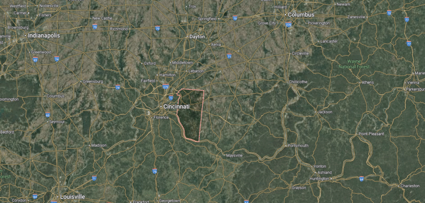
Clermont County is positioned in southwestern Ohio, directly east of Cincinnati along the Ohio River. It is bordered by Hamilton County to the west, Brown County to the east, and Warren County to the north. The county covers nearly 460 square miles, blending riverfront lowlands with rolling hills and suburban growth.
Batavia serves as the county seat, while Milford and Amelia are among the other notable communities. The Ohio River forms much of the southern boundary, offering both transportation routes and recreational opportunities. With its mix of historic river towns, expanding suburbs, and rural landscapes, Clermont County connects Greater Cincinnati with the Ohio River Valley.
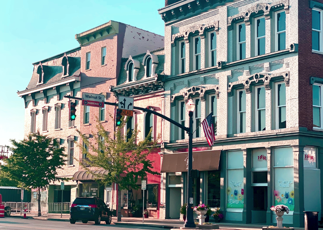
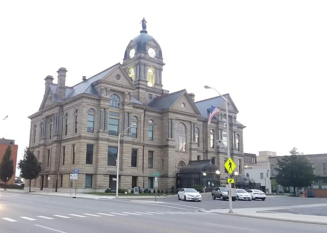
#27. Allen County, Ohio
– Overall Rank: 875
– Population: 102,087
– Median household income: $58,976
– Median home value: $147,000 (67% own)
– Median rent: $844 (33% rent)
– Top public schools: Bluffton Elementary School (grade A), Maplewood Elementary School (grade A minus), Shawnee Middle School (grade A minus)
– Top private schools: Lima Central Catholic High School (grade B+), Delphos St. John’s Catholic School (grade B minus), Temple Christian School (grade B minus)
– Top places: Bluffton (grade A), Fort Shawnee (grade A minus), Delphos (grade B+)
About
Allen County, Ohio sits in the state’s northwest, where agriculture, industry, and community life have long shaped its identity. The city of Lima, the county seat, anchors the region with a history tied to manufacturing, railroads, and civic institutions. Smaller towns and farmland surrounding it preserve the rural traditions that continue to define much of the county’s character.
Local fairs, cultural festivals, and school-centered events bring residents together and reinforce a strong sense of pride. Parks, trails, and natural spaces offer opportunities for recreation while connecting people to the land. Allen County stands as a place where heritage, resilience, and progress work side by side in shaping daily life.
Where is Allen County?
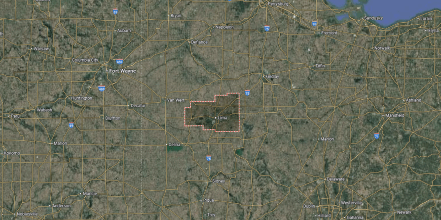
Allen County is located in northwest Ohio, covering roughly 405 square miles of fertile farmland and river valleys. It is bordered by Putnam County to the north, Auglaize County to the south, and Hardin County to the east, with Van Wert and Paulding counties forming its western edge. The landscape is predominantly flat and agricultural, shaped by small waterways that tie into the Auglaize River.
Lima, the county seat, sits near the center and serves as the region’s commercial and cultural hub. Other communities include Delphos, which straddles the county’s western line, and Bluffton in the northeast. Allen County ties together rural farming traditions with industrial and educational growth, bridging smaller towns with the larger economy of northwest Ohio.
#26. Miami County, Ohio
– Overall Rank: 870
– Population: 108,818
– Median household income: $71,440
– Median home value: $190,900 (73% own)
– Median rent: $906 (27% rent)
– Top public schools: Newton Elementary School (grade A), Nevin Coppock Elementary School (grade A), L.T. Ball Intermediate School (grade A minus)
– Top private schools: Troy Christian School (grade B+), Troy Christian Elementary School (grade unavailable), St. Patrick School (grade unavailable)
– Top places: Tipp City (grade A), Troy (grade A minus), Covington (grade B)
You may also like: The biggest health care data breaches you should know about in Ohio
About
Miami County, Ohio reflects a heritage rooted in its position along the Great Miami River, where fertile farmland and small towns have long flourished. The city of Troy, the county seat, serves as a hub of culture and commerce with historic districts and community institutions. Surrounding towns like Piqua and Tipp City carry forward traditions of craftsmanship, industry, and strong civic life.
Residents celebrate through county fairs, festivals, and neighborhood gatherings that highlight local pride. Outdoor recreation thrives along rivers, parks, and trails that connect people to both land and history. Miami County endures as a place where heritage, community, and steady growth come together in lasting form.
Where is Miami County?
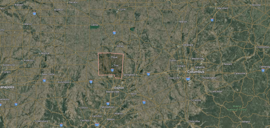
Miami County is located in west-central Ohio, just north of Dayton in the Miami Valley region. It is bordered by Shelby County to the north, Champaign County to the east, and Montgomery County to the south. The land stretches over 400 square miles, with fertile farmland and the Great Miami River flowing through its center.
Troy, the county seat, sits near the river and serves as the main commercial and cultural hub. Other communities include Piqua to the north and Tipp City to the south, each with strong local identities. With its combination of agriculture, manufacturing, and historic towns, Miami County reflects both rural heritage and modern growth.
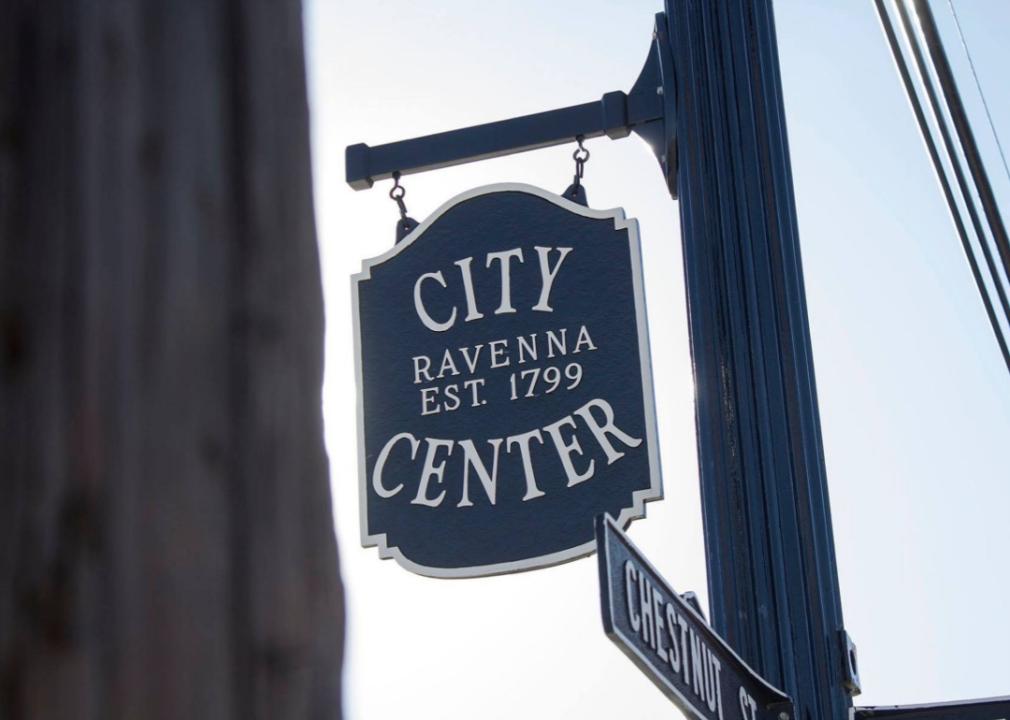
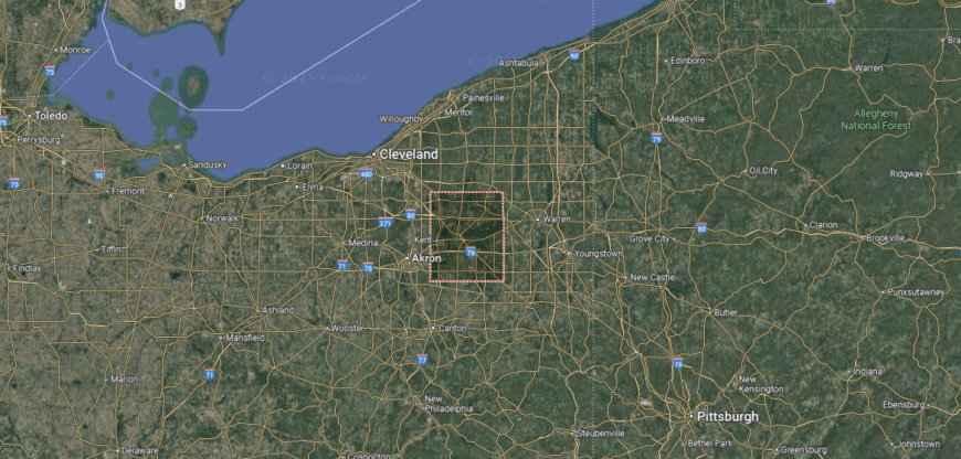
#25. Portage County, Ohio
– Overall Rank: 847
– Population: 161,217
– Median household income: $69,796
– Median home value: $197,100 (71% own)
– Median rent: $990 (29% rent)
– Top public schools: Aurora High School (grade A), Leighton Elementary School (grade A), Harmon Middle School (grade A)
– Top private schools: St. Patrick Elementary School (grade unavailable), St. Joseph Elementary School (grade unavailable), Valley Christian Academy (grade unavailable)
– Top places: Aurora (grade A+), Hiram (grade A), Kent (grade B+)
About
Portage County, Ohio blends the energy of a university hub with the traditions of rural and small-town life. The city of Ravenna serves as the county seat, while Kent anchors cultural and educational life through Kent State University. Surrounding farmland, woodlands, and villages add to the county’s balance of growth, history, and community identity.
Residents gather for concerts, festivals, and school events that highlight both heritage and creativity. Outdoor recreation is abundant in parks, lakes, and trails that tie people closely to the natural landscape. Portage County stands as a place where education, tradition, and community spirit create a dynamic way of life.
Where is Portage County?
🔥 Would you like to save this?
Portage County sits in the northeastern part of Ohio, within the state’s Western Reserve region. It is bordered by Geauga County to the north, Trumbull County to the east, and Summit County to the west, while Stark County lies to the south. The county spans nearly 500 square miles, with a mix of farmland, small towns, and growing suburban areas.
Ravenna, the county seat, is located near the center, while Kent is the largest city and home to Kent State University. Smaller communities such as Streetsboro, Garrettsville, and Aurora add to the county’s diverse character. With its blend of education, agriculture, and suburban development, Portage County serves as a vital link between Cleveland, Akron, and Youngstown.
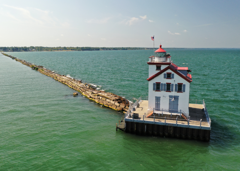
#24. Lorain County, Ohio
– Overall Rank: 834
– Population: 313,101
– Median household income: $67,272
– Median home value: $191,900 (73% own)
– Median rent: $886 (27% rent)
– Top public schools: Avon Middle School (grade A), Avon Heritage Elementary School (grade A), Learwood Middle School (grade A)
– Top private schools: Lake Ridge Academy (grade A+), Elyria Catholic High School (grade A minus), First Baptist Christian School (grade A minus)
– Top places: Avon (grade A+), Oberlin (grade A+), Avon Lake (grade A)
About
Lorain County, Ohio rests along the southern shore of Lake Erie, where industry, agriculture, and lakefront culture have long shaped its character. The city of Elyria, the county seat, anchors civic life, while Lorain itself reflects a proud heritage tied to steelmaking, shipbuilding, and immigrant traditions. Smaller towns and rural areas add balance, preserving farming and community-centered living.
Local fairs, parades, and cultural festivals highlight the county’s diversity and strong social bonds. Outdoor life thrives on Lake Erie’s shoreline, in parks, and across trails that connect residents to the land and water. Lorain County remains a place where history, resilience, and community identity continue to define everyday life.
Where is Lorain County?
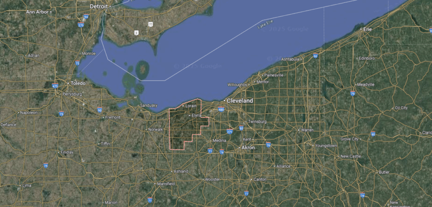
Lorain County is positioned in the northeastern part of Ohio, along the southern shore of Lake Erie. It is bordered by Cuyahoga County to the east, Huron County to the west, and Medina and Ashland counties to the south. Spanning more than 490 square miles, the county features lakefront areas, farmland, and expanding suburban communities.
Elyria, the county seat, lies near the center, while Lorain, the largest city, sits along Lake Erie at the mouth of the Black River. Other towns include Avon, Amherst, and Wellington, each contributing to the county’s mix of urban and rural life. With its industrial heritage, lakefront access, and growing suburban corridors, Lorain County ties together commerce, community, and natural resources.
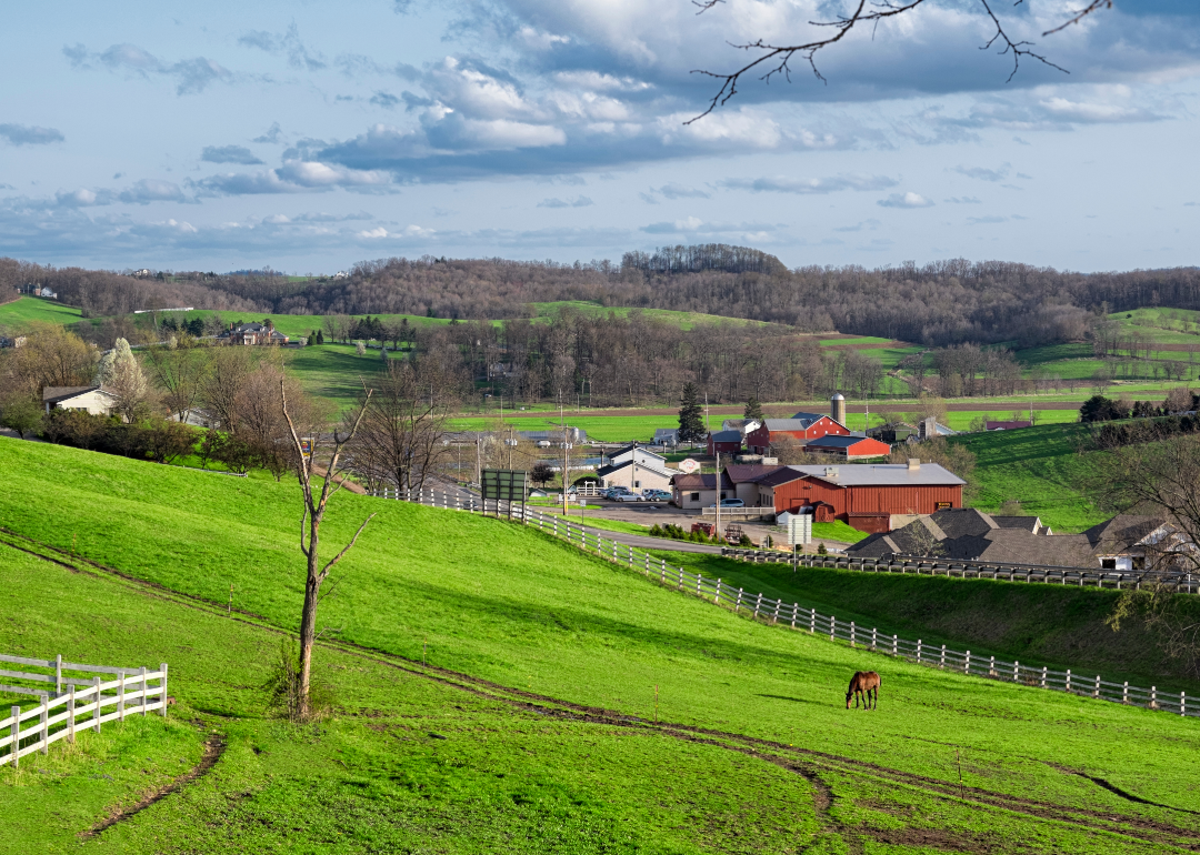
#23. Wayne County, Ohio
– Overall Rank: 813
– Population: 116,680
– Median household income: $70,320
– Median home value: $189,800 (75% own)
– Median rent: $824 (25% rent)
– Top public schools: Norwayne Middle School (grade A minus), Hazel Harvey Elementary School (grade A minus), Dalton Middle School (grade A minus)
– Top private schools: Central Christian School (grade B), Kingsway Christian School (grade B minus), St. Mary of Immaculate Conception School (grade A)
– Top places: Doylestown (grade A minus), Orrville (grade A minus), Wooster (grade B+)
About
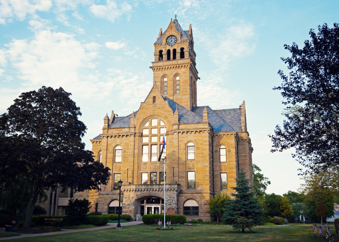
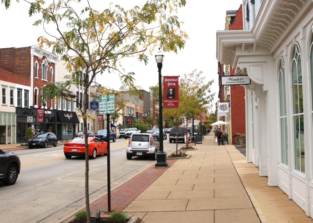
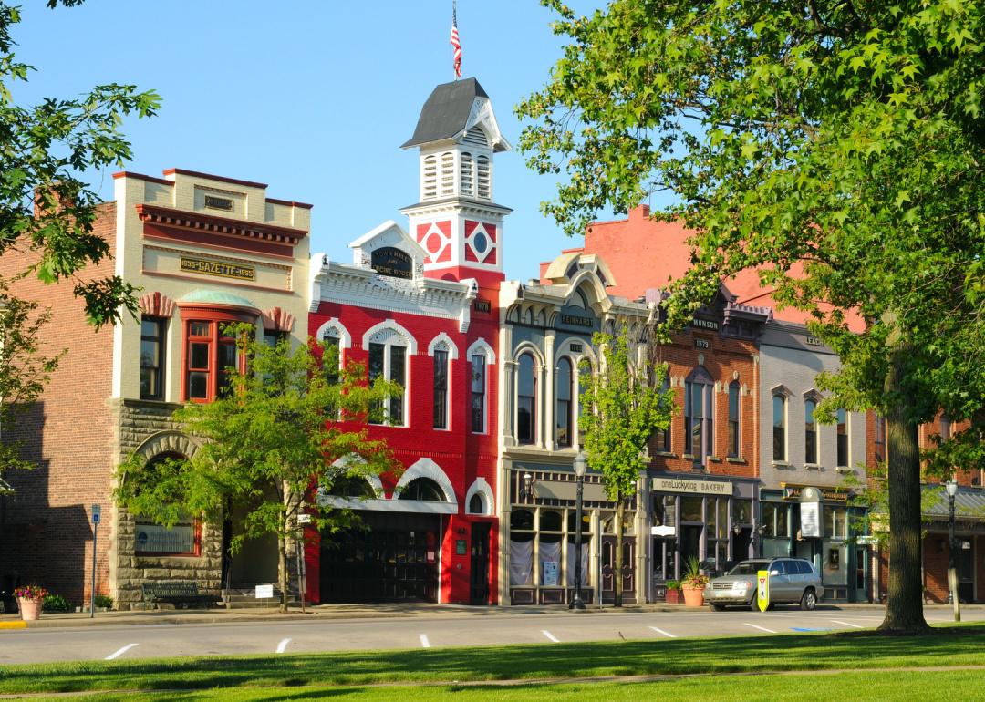
Wayne County, Ohio is set in the heart of Amish Country, where agriculture and tradition remain central to daily life. The city of Wooster, the county seat, is known for its historic downtown, cultural institutions, and ties to education through The College of Wooster. Across the county, farms, villages, and markets reflect a steady connection to the land and to generational heritage.
Community pride is celebrated through fairs, cultural festivals, and gatherings that bring neighbors together. Outdoor spaces, from rolling farmland to scenic trails, provide both livelihood and recreation. Wayne County stands as a place where tradition, rural strength, and community values guide the rhythm of life.
Where is Wayne County?
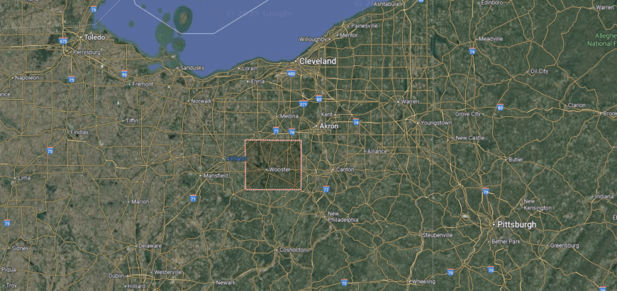
Wayne County is in northeastern Ohio, bordered by Medina to the north, Stark to the east, Ashland to the west, and Holmes to the south. It spans over 550 square miles with rolling hills, fertile farmland, and a strong agricultural base.
Wooster, the county seat, anchors the region and is home to The College of Wooster. Other towns include Orrville, noted for its food industry, and Dalton in the north. The county blends rural landscapes, small-town life, and educational influence.
#22. Ottawa County, Ohio
– Overall Rank: 625
– Population: 40,367
– Median household income: $69,515
– Median home value: $179,100 (82% own)
– Median rent: $846 (18% rent)
– Top public schools: Oak Harbor Middle School (grade A minus), R.C. Waters Elementary School (grade B+), Danbury High School (grade B+)
– Top private schools: Immaculate Conception School (grade unavailable), St. Boniface Catholic School and Preschool (grade unavailable), Ottawa County Christian Academy (grade unavailable)
– Top places: Port Clinton (grade B+), Genoa (grade B+), Curtice (grade B)
About
Ottawa County, Ohio stretches along the Lake Erie shoreline, where water, islands, and harbors shape both livelihood and recreation. The county seat of Port Clinton is known as the “Walleye Capital of the World,” anchoring civic life while serving as a gateway to the Lake Erie Islands. Fishing, boating, and tourism join agriculture to create a diverse and enduring economy.
Local festivals, lakefront events, and school activities highlight the county’s community spirit and traditions. Outdoor recreation thrives on the water, in state parks, and across the islands that define its landscape. Ottawa County remains a place where lake heritage, community pride, and natural beauty come together in lasting form.
Where is Ottawa County?
Ottawa County is located in northern Ohio along the southern shore of Lake Erie. It is bordered by Sandusky County to the south and Erie County to the west, with Wood County touching its southeastern edge. The county spans about 255 square miles of land, with much of its character shaped by the lakefront and the Sandusky Bay.
Port Clinton, the county seat, lies on the lake and serves as a gateway to the Lake Erie Islands. Other communities include Oak Harbor inland and Put-in-Bay on South Bass Island, a popular destination. With its mix of shoreline, islands, and recreational opportunities, Ottawa County is closely tied to tourism, fishing, and lake-centered living.
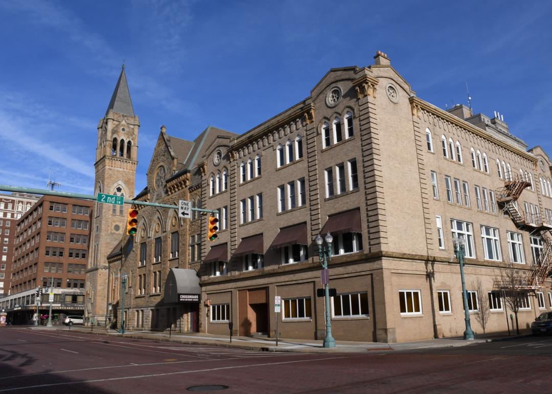
#21. Fairfield County, Ohio
– Overall Rank: 602
– Population: 159,371
– Median household income: $82,969
– Median home value: $247,800 (75% own)
– Median rent: $1,042 (25% rent)
– Top public schools: Toll Gate Middle School (grade A minus), Pickerington High School North (grade A minus), Pickerington High School Central (grade A minus)
– Top private schools: William V. Fisher Catholic High School (grade A minus), Fairfield Christian Academy (grade B minus), St. Mary Elementary School (grade unavailable)
– Top places: Pickerington (grade A), Millersport (grade B minus), Lancaster (grade B minus)
You may also like: Best beach towns on the Great Lakes
About
Fairfield County, Ohio lies at the edge of the Appalachian foothills, where rolling hills meet farmland and growing suburban communities. The city of Lancaster, the county seat, preserves historic districts and civic traditions while serving as a hub of commerce and culture. Across the county, small towns and countryside reflect a balance of heritage and steady development tied to nearby Columbus.
Residents come together at fairs, festivals, and school events that showcase both tradition and community pride. Outdoor recreation is abundant in parks, trails, and natural areas like Hocking Hills, which connect people to the land. Fairfield County endures as a place where history, growth, and rural identity blend into a lasting way of life.
Where is Fairfield County?
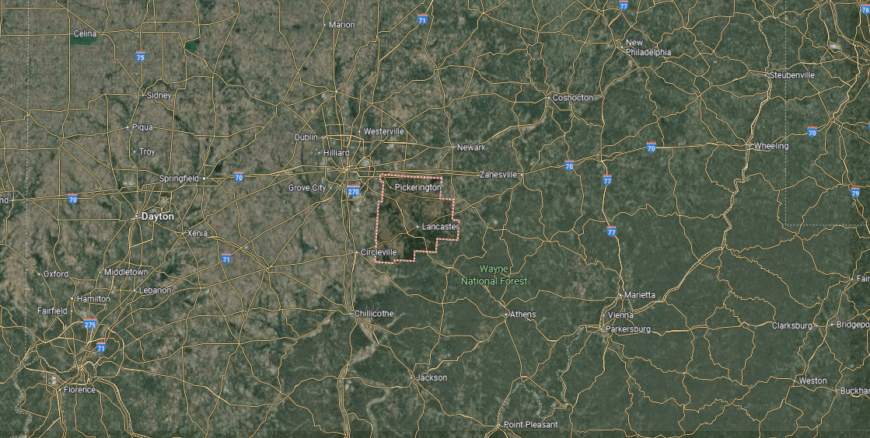
Fairfield County sits in central Ohio, just southeast of Columbus in the state’s Hocking Valley region. It is bordered by Licking County to the north, Perry County to the east, and Pickaway County to the west, with Hocking County along the southern edge. The county spans more than 500 square miles, blending rolling hills in the south with flatter farmland in the north.
Lancaster, the county seat, is positioned near the center and serves as the county’s largest city. Other communities include Pickerington on the western edge and Baltimore to the northeast. With its mix of agriculture, growing suburbs, and access to the Hocking Hills, Fairfield County connects rural tradition with expanding development.
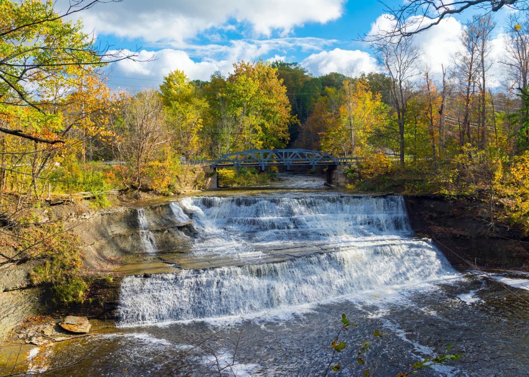
#20. Stark County, Ohio
– Overall Rank: 564
– Population: 374,199
– Median household income: $63,130
– Median home value: $164,900 (68% own)
– Median rent: $838 (32% rent)
– Top public schools: Strausser Elementary School (grade A), Lake Primary School (grade A), Clearmount Elementary School (grade A)
– Top private schools: St. Thomas Aquinas High School & Middle School (grade A minus), Central Catholic High School (grade A minus), Lake Center Christian School (grade B)
– Top places: Greentown (grade A), North Canton (grade A), Uniontown (grade A)
About
Stark County, Ohio reflects a legacy shaped by industry, innovation, and cultural tradition in the state’s northeast. The city of Canton, the county seat, is home to the Pro Football Hall of Fame, while also carrying a strong history tied to manufacturing and civic life. Surrounding towns and farmland preserve rural roots even as suburban growth continues to expand.
Festivals, school events, and community celebrations highlight the county’s pride and bring people together. Parks, trails, and nearby lakes provide space for outdoor recreation and reflection on the region’s landscape. Stark County stands as a place where history, culture, and resilience remain central to everyday life.
Where is Stark County?
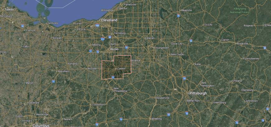
Stark County is positioned in northeastern Ohio, spanning more than 570 square miles of farmland, hills, and industrial centers. It is bordered by Summit County to the north, Mahoning and Carroll counties to the east, and Wayne and Holmes counties to the west and south. Tuscarawas County runs along its southeastern edge, connecting Stark to Ohio’s Appalachian foothills.
Canton, the county seat, anchors the region in the east-central section. Other notable communities include Massillon to the west and Alliance near the eastern border. With its blend of urban density, agricultural areas, and historic towns, Stark County sits at a crossroads between Ohio’s industrial northeast and its rural Appalachian gateway.
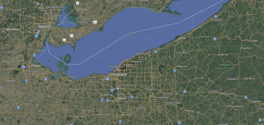
#19. Lake County, Ohio
– Overall Rank: 542
– Population: 232,236
– Median household income: $76,835
– Median home value: $189,600 (75% own)
– Median rent: $1,027 (25% rent)
– Top public schools: Istem Geauga Early College High School (grade A minus), Kirtland Elementary School (grade A minus), Hopkins Elementary School (grade A minus)
– Top private schools: Andrews Osborne Academy (grade A+), Lake Catholic High School (grade A minus), Mentor Christian School (grade C+)
– Top places: Kirtland (grade A), Mentor (grade A), Willoughby (grade A minus)
About
Lake County, Ohio stretches along the southern shore of Lake Erie, where vineyards, harbors, and growing towns define its identity. The county seat of Painesville anchors civic life, while communities like Mentor and Willoughby reflect both historic charm and suburban development. Agriculture, shipping, and commerce blend with recreation on the lake to shape a diverse local character.
Residents gather through festivals, farmers’ markets, and cultural events that strengthen community ties. Outdoor opportunities flourish in parks, trails, and along Lake Erie’s shoreline, connecting people closely to the water and land. Lake County endures as a region where tradition, growth, and natural beauty remain strongly intertwined.
Where is Lake County?
🔥 Would you like to save this?
Lake County is positioned in northeastern Ohio, along the southern shore of Lake Erie. It is bordered by Geauga County to the south, Cuyahoga County to the west, and Ashtabula County to the east. Covering about 230 square miles, it is the smallest county by land area in the state but holds a strong mix of lakefront, suburban, and rural landscapes.
Painesville, the county seat, sits near the center along the Grand River, while Mentor is the largest city and a major suburban hub. Other communities include Willoughby and Eastlake, both tied closely to the Cleveland metropolitan area. With Lake Erie, rivers, and expanding suburbs, Lake County blends natural beauty with economic and residential growth.
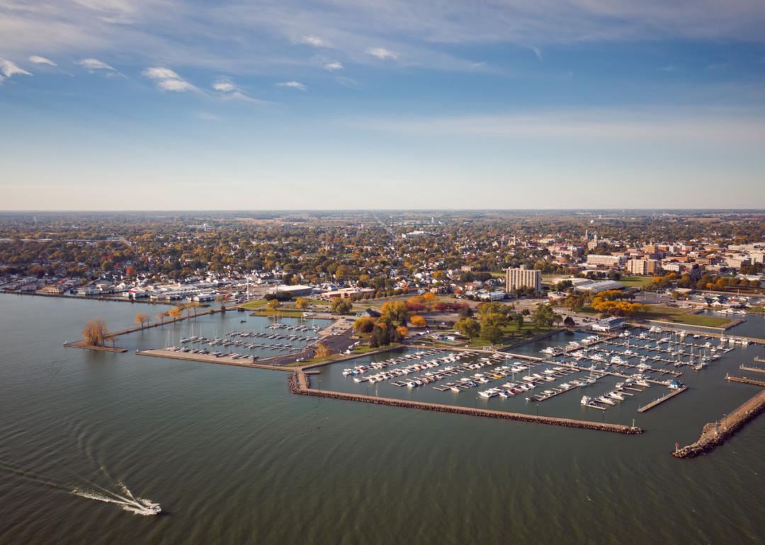
#18. Erie County, Ohio
– Overall Rank: 478
– Population: 75,299
– Median household income: $65,171
– Median home value: $169,400 (71% own)
– Median rent: $884 (29% rent)
– Top public schools: Woodlands Intermediate School (grade B+), Edison Middle School (formerly Berlin-Milan Middle School) (grade B+), Edison Elementary School (formerly Milan Elementary) (grade B+)
– Top private schools: Sandusky Central Catholic School (grade A minus), St. Peter Elementary School (grade unavailable), Firelands Montessori Academy (grade unavailable)
– Top places: Huron (grade B+), Milan (grade B+), Sandusky (grade B+)

About
Erie County, Ohio is defined by its position along Lake Erie, where water, islands, and shoreline communities shape both history and economy. The city of Sandusky, the county seat, anchors the region with its historic downtown, port heritage, and reputation as a center for tourism and recreation. Beyond the lakefront, farmland and smaller towns contribute to the county’s balance of rural tradition and modern growth.
Local life thrives through festivals, waterfront events, and gatherings that highlight community pride. Outdoor recreation is abundant on the lake, in parks, and across the Lake Erie Islands, connecting residents and visitors alike to the natural landscape. Erie County remains a place where heritage, recreation, and community identity come together in lasting form.
Where is Erie County?
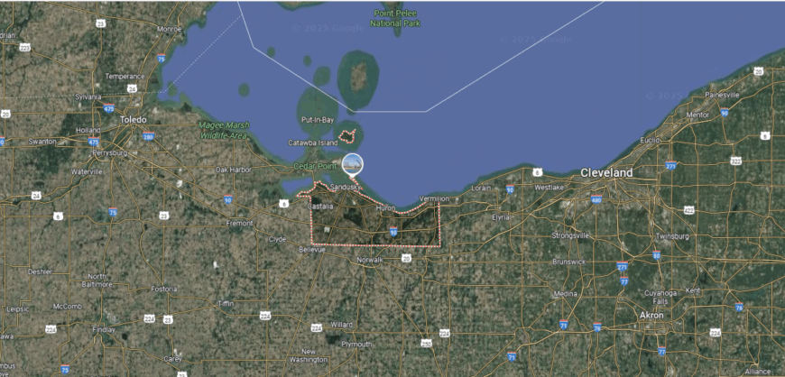
Erie County is located along the northern edge of Ohio, bordered by Lake Erie to the north and Huron County to the south. Sandusky Bay cuts into the shoreline, giving the county a distinct geography that includes islands, peninsulas, and marshlands. The county covers just over 250 square miles of land, with much of its identity shaped by its waterfront.
Sandusky, the county seat, lies along the bay and serves as a hub for tourism and industry. Other communities include Huron to the east and Vermilion on the western edge, both connected to the lakefront. With Cedar Point amusement park, island access, and lake-centered commerce, Erie County ties recreation, history, and natural resources together.
#17. Montgomery County, Ohio
– Overall Rank: 419
– Population: 536,121
– Median household income: $61,942
– Median home value: $154,300 (62% own)
– Median rent: $925 (38% rent)
– Top public schools: Dayton Regional STEM School (grade A+), Oakwood Junior High School (grade A+), Harman Elementary School (grade A+)
– Top private schools: The Miami Valley School (grade A+), Chaminade Julienne Catholic High School (grade A), Archbishop Alter High School (grade A)
– Top places: Oakwood (grade A+), Centerville (grade A+), Kettering (grade A)

About
Montgomery County, Ohio rests in the Miami Valley, where history, innovation, and community life converge. The city of Dayton, the county seat, is recognized for its role in aviation history, strong manufacturing roots, and a tradition of invention that shaped the region’s character. Surrounding towns and suburban areas reflect both the county’s industrial heritage and its steady adaptation to modern growth.
Residents gather through cultural festivals, concerts, and civic events that strengthen local pride and highlight creativity. Parks, trails, and rivers offer opportunities for recreation while keeping people connected to the landscape. Montgomery County endures as a place where history, resilience, and innovation continue to guide daily life.
Where is Montgomery County?
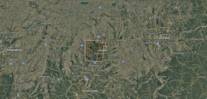
Montgomery County is situated in southwestern Ohio, at the heart of the Miami Valley region. It is bordered by Miami County to the north, Greene County to the east, and Warren County to the south, with Preble and Darke counties lying to the west. Spanning about 460 square miles, the county combines fertile farmland, river valleys, and extensive urban development.
Dayton, the county seat and largest city, anchors the region with a strong history in aviation and industry. Other communities include Kettering, Miamisburg, and Huber Heights, each contributing to the county’s suburban and economic growth. With the Great Miami River running through its center, Montgomery County blends historic innovation with modern metropolitan life.
#16. Putnam County, Ohio
– Overall Rank: 409
– Population: 34,400
– Median household income: $79,453
– Median home value: $176,200 (86% own)
– Median rent: $807 (14% rent)
– Top public schools: Miller City Elementary School (grade A), Kalida Elementary School (grade A), Ottoville Elementary School (grade A)
– Top private schools: Sts. Peter & Paul Catholic School (grade unavailable), St. Anthony of Padua School (grade unavailable), St. Mary’s Catholic School (grade unavailable)
– Top places: Ottawa (grade A minus), Glandorf (grade B+), Kalida (grade A)
You may also like: Best lookout points in Ohio
About
Putnam County, Ohio is a rural region in the state’s northwest, where farmland and small towns create a steady rhythm of community life. The county seat of Ottawa anchors civic activity with its courthouse square and historic presence. Agriculture has long been the backbone of the county, shaping both its economy and its traditions.
Community gatherings are centered on fairs, festivals, and school events that bring neighbors together across generations. Parks, rivers, and open fields provide residents with spaces for recreation and reflection. Putnam County stands as a place where rural heritage, community pride, and a connection to the land remain enduring values.
Where is Putnam County?
Putnam County is located in northwestern Ohio, within a largely agricultural region of the state. It is bordered by Henry County to the north, Allen County to the south, and Hancock County to the east, with Paulding and Van Wert counties along the western side. The county covers about 480 square miles, with flat, fertile farmland defining much of its landscape.
Ottawa, the county seat, lies near the center and serves as the main hub of government and commerce. Other towns include Columbus Grove to the north, Leipsic to the west, and Continental near the Henry County line. Strong farming traditions, small-town communities, and close-knit rural life characterize Putnam County.
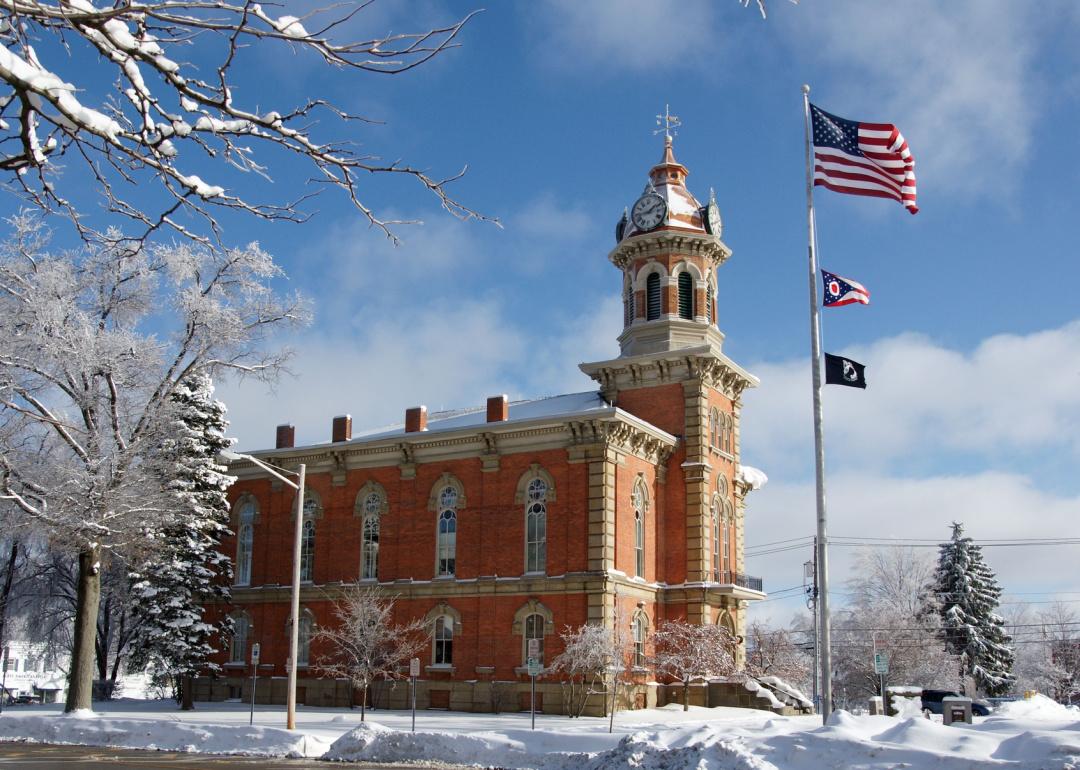
#15. Hancock County, Ohio
– Overall Rank: 403
– Population: 75,072
– Median household income: $67,006
– Median home value: $179,600 (69% own)
– Median rent: $877 (31% rent)
– Top public schools: Liberty-Benton Middle School (grade A), Van Buren Elementary School (grade A minus), Liberty-Benton Elementary School (grade A minus)
– Top private schools: Heritage Christian School (grade A minus), St. Michael School (grade unavailable), Trinity Evangelical Lutheran School (grade unavailable)
– Top places: Findlay (grade A minus), Liberty Township (grade A), Marion Township (grade A)
About
Hancock County, Ohio blends a rich agricultural foundation with the energy of a thriving urban center. The city of Findlay, the county seat, is known as the “Flag City” and serves as a hub of culture, commerce, and community pride. Beyond the city, farmland and smaller towns preserve a steady rhythm tied to tradition and rural living.
Local life is marked by fairs, festivals, and civic events that highlight both heritage and progress. Outdoor opportunities in parks, rivers, and open countryside connect residents to the natural landscape. Hancock County endures as a place where tradition, growth, and community spirit continue to shape daily life.
Where is Hancock County?
Hancock County is positioned in northwestern Ohio, bordered by Wood County to the north, Hardin County to the south, and Seneca County to the east. It spans nearly 535 square miles, with a landscape dominated by fertile farmland and small river valleys, particularly those connected to the Blanchard River. The county serves as a key part of Ohio’s agricultural and manufacturing corridor.
Findlay, the county seat and largest city, lies near the center and is known for its industrial base and educational institutions. Other communities include Arlington to the south, McComb to the west, and Mount Blanchard in the southeast. With its mix of industry, farming, and community life, Hancock County blends rural traditions with urban development.
#14. Geauga County, Ohio
– Overall Rank: 382
– Population: 95,455
– Median household income: $97,162
– Median home value: $288,000 (87% own)
– Median rent: $1,009 (13% rent)
– Top public schools: Gurney Elementary School (grade A), Kenston Middle School (grade A), Chardon Middle School (grade A)
– Top private schools: Hawken School (grade A+), Notre Dame-Cathedral Latin School (grade A minus), Hershey Montessori School Adolescent Campus (grade A minus)
– Top places: South Russell (grade A+), Bainbridge (grade A), Chardon (grade A minus)

🔥 Would you like to save this?
About
Geauga County, Ohio is set in the state’s northeast, where rolling farmland, forests, and small towns shape its rural identity. The county seat of Chardon anchors community life, while Amish communities and agricultural traditions add a distinctive character. Local markets, dairies, and maple syrup production reflect the county’s enduring connection to the land.
Residents come together through seasonal festivals, fairs, and school-centered gatherings that strengthen civic ties. Parks, trails, and natural preserves provide recreation while highlighting the county’s scenic beauty. Geauga County remains a place where heritage, rural values, and community pride form the foundation of everyday life.
Where is Geauga County?
Geauga County is located in northeastern Ohio, about 30 miles east of Cleveland. It is bordered by Lake County to the northwest, Ashtabula County to the northeast, and Portage County to the south, with Cuyahoga County along the western edge. Covering roughly 400 square miles, the county is noted for its rolling hills, woodlands, and agricultural lands.
Chardon, the county seat, sits near the center on higher ground, often known for heavy snowfall due to its elevation. Other communities include Bainbridge, Chesterland, and Burton, each contributing to the county’s rural and suburban mix. With a strong Amish presence, scenic countryside, and proximity to Cleveland, Geauga County reflects both tradition and quiet growth.
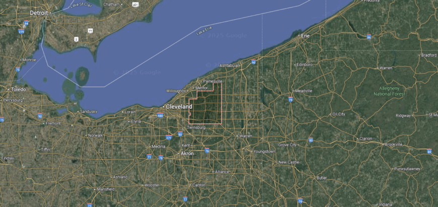
#13. Cuyahoga County, Ohio
– Overall Rank: 360
– Population: 1,256,620
– Median household income: $60,074
– Median home value: $168,700 (58% own)
– Median rent: $952 (42% rent)
– Top public schools: Solon High School (grade A+), Solon Middle School (grade A+), Hilltop Elementary School (grade A+)
– Top private schools: University School (grade A+), Laurel School (grade A+), Hathaway Brown School (grade A+)
– Top places: Shaker Heights (grade A+), Pepper Pike (grade A+), Solon (grade A+)

About
Cuyahoga County, Ohio is the state’s most populous county, defined by its urban energy along Lake Erie and the Cuyahoga River. The city of Cleveland, the county seat, anchors the region with its cultural institutions, industrial legacy, and role as an economic hub. Surrounding suburbs and neighborhoods reflect a wide diversity of traditions, industries, and community life.
Residents experience a vibrant culture through music, sports, festivals, and civic events that showcase both heritage and creativity. Outdoor opportunities are found along lakefront parks, trails, and the Cuyahoga Valley National Park, connecting people to both city and nature. Cuyahoga County endures as a place where history, innovation, and cultural identity come together in dynamic form.
Where is Cuyahoga County?
Cuyahoga County is located in northeastern Ohio, along the southern shore of Lake Erie. It is bordered by Lorain County to the west, Medina and Summit counties to the south, and Geauga and Lake counties to the east. Spanning more than 450 square miles of land, the county combines dense urban centers, suburban corridors, and stretches of lakefront.
Cleveland, the county seat and largest city, anchors the region as a cultural, economic, and industrial hub. Other communities include Parma, Lakewood, and Shaker Heights, each with their own historic and suburban character. With Lake Erie, major universities, and a rich industrial legacy, Cuyahoga County stands as one of the most influential regions in Ohio.
#12. Mahoning County, Ohio
– Overall Rank: 342
– Population: 227,979
– Median household income: $54,279
– Median home value: $132,000 (70% own)
– Median rent: $753 (30% rent)
– Top public schools: Canfield Village Middle School (grade A), Austintown Elementary School (grade A), West Boulevard Elementary School (grade A)
– Top private schools: Ursuline High School (grade A), Cardinal Mooney High School (grade A), Valley Christian Schools (grade A minus)
– Top places: Canfield (grade A+), Poland (grade A), Boardman (grade A minus)
About
Mahoning County, Ohio carries a legacy rooted in the steel industry, which shaped both its economy and identity for generations. The city of Youngstown, the county seat, reflects this industrial past while also serving as a center of culture, education, and revitalization. Smaller towns and rural areas balance the county, preserving traditions tied to farming and community life.
Festivals, school activities, and cultural events highlight resilience and local pride across neighborhoods. Parks, rivers, and nearby preserves offer space for recreation and reflection beyond the urban core. Mahoning County stands as a place where history, adaptation, and community values continue to guide its path forward.
Where is Mahoning County?
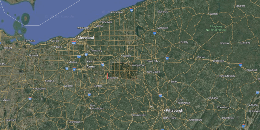
Mahoning County is set in northeastern Ohio, along the border with Pennsylvania. It is bordered by Trumbull County to the north, Columbiana County to the south, and Portage County to the west. The county covers about 425 square miles, with a mix of urban centers, suburban areas, and stretches of farmland.
Youngstown, the county seat and largest city, lies in the Mahoning Valley and has long been tied to the steel industry. Other communities include Struthers, Canfield, and Sebring, each adding to the county’s local character. With its industrial heritage, educational institutions, and proximity to both Cleveland and Pittsburgh, Mahoning County remains a vital part of Ohio’s northeastern region.
#11. Butler County, Ohio
– Overall Rank: 333
– Population: 388,327
– Median household income: $77,062
– Median home value: $224,300 (69% own)
– Median rent: $1,048 (31% rent)
– Top public schools: Independence Elementary School (grade A), Heritage Early Childhood School (grade A), Hopewell Early Childhood School (grade A)
– Top private schools: Cincinnati Christian Schools (grade A minus), Stephen T. Badin High School (grade B+), St. John XXIII Catholic School (grade A)
– Top places: Beckett Ridge (grade A+), Wetherington (grade A), Oxford (grade A)
You may also like: The most popular poker players in Ohio

About
Butler County, Ohio lies in the southwestern corner of the state, where farmland, suburban growth, and historic towns create a varied landscape. The city of Hamilton, the county seat, reflects a strong industrial heritage alongside efforts of cultural renewal. Nearby, Oxford brings the influence of Miami University, adding an academic and artistic dimension to the county’s character.
Local traditions thrive through festivals, fairs, and school events that strengthen community bonds. Parks, rivers, and trails provide abundant opportunities for recreation and connection to the outdoors. Butler County endures as a place where history, education, and community pride come together in lasting form.
Where is Butler County?
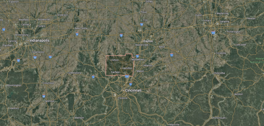
Butler County is located in southwestern Ohio, within the Greater Cincinnati region. It is bordered by Preble County to the north, Warren County to the east, and Hamilton County to the south, while the Indiana state line marks its western edge. Covering about 470 square miles, the county features a mix of fertile farmland, suburban communities, and growing urban corridors.
Hamilton, the county seat, sits along the Great Miami River near the center of the county. Other key communities include Middletown to the north and West Chester Township to the south, both major hubs of population and commerce. With its blend of historic towns, expanding suburbs, and river valleys, Butler County connects rural heritage with metropolitan growth.
#10. Lucas County, Ohio
– Overall Rank: 312
– Population: 430,014
– Median household income: $57,265
– Median home value: $144,200 (62% own)
– Median rent: $879 (38% rent)
– Top public schools: Ottawa Hills High School (grade A), Toledo Early College High School (grade A), Fallen Timbers Middle School (grade A)
– Top private schools: Maumee Valley Country Day School (grade A+), St. John’s Jesuit High School and Academy (grade A), Notre Dame Academy (grade A)
– Top places: Ottawa Hills (grade A+), Sylvania (grade A+), Maumee (grade A)
About
Lucas County, Ohio anchors the state’s northwest corner, where Lake Erie and the Maumee River have long shaped its economy and identity. The city of Toledo, the county seat, carries a legacy in glassmaking, automotive manufacturing, and shipping, while also serving as a center for culture and education. Surrounding suburbs and communities contribute to the county’s diversity, balancing industry with neighborhood life.
Residents engage in festivals, concerts, and civic events that highlight both tradition and creativity. Outdoor recreation thrives along the lakefront, in Metroparks, and on the Maumee River, connecting people to the natural setting. Lucas County stands as a place where history, innovation, and community spirit continue to define everyday life.
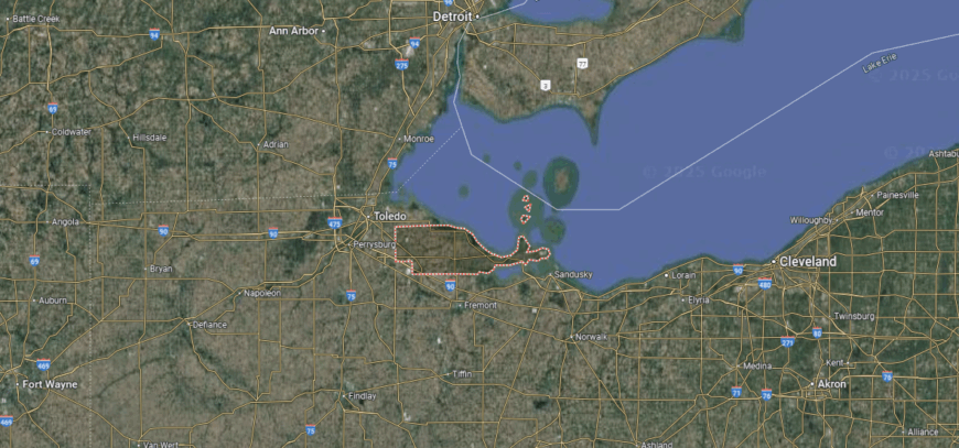
Where is Lucas County?
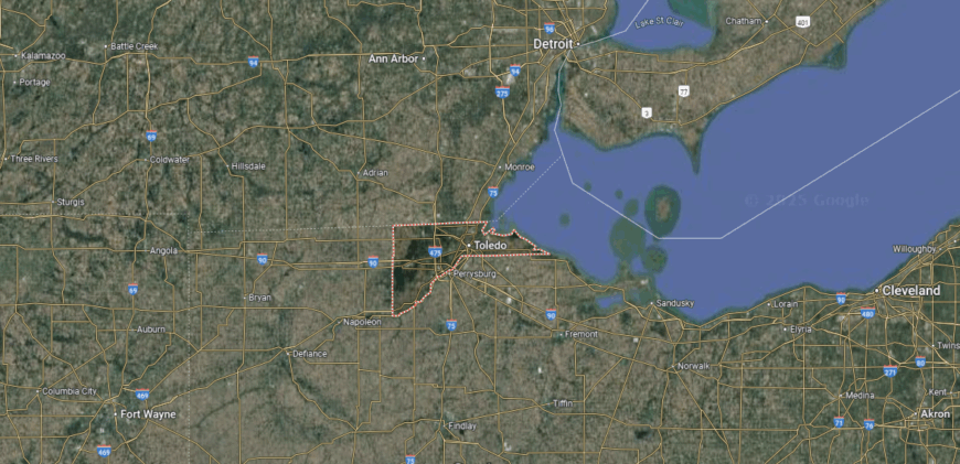
Lucas County is situated in the northwestern corner of Ohio, along the western end of Lake Erie. It is bordered by Ottawa County to the east, Wood County to the south, and Fulton County to the west, while the Michigan state line forms its northern boundary. Spanning about 340 square miles, the county combines lakefront, river valleys, and densely developed urban areas.
Toledo, the county seat and largest city, anchors the region at the mouth of the Maumee River. Other communities include Sylvania, Maumee, and Oregon, each contributing to the county’s suburban and industrial mix. With its port access on Lake Erie, strong manufacturing base, and cultural institutions, Lucas County serves as a gateway between Ohio and Michigan.
#9. Union County, Ohio
– Overall Rank: 262
– Population: 63,411
– Median household income: $104,496
– Median home value: $282,900 (80% own)
– Median rent: $1,144 (20% rent)
– Top public schools: Dublin Jerome High School (grade A+), Glacier Ridge Elementary School (grade A+), Abraham Depp Elementary School (grade A)
– Top private schools: St. John’s Lutheran School (grade unavailable), Trinity Lutheran School (grade unavailable), St. Paul Lutheran School (grade unavailable)
– Top places: Marysville (grade A minus), Jerome Township (grade A+), New California (grade A+)
About
Union County, Ohio reflects a mix of agricultural heritage and rapid growth tied to its proximity to the Columbus metropolitan area. The city of Marysville, the county seat, anchors the region with strong civic life and a history tied to farming and industry. Surrounding towns and farmland maintain a rural character even as development continues to expand.
Community spirit is expressed through fairs, parades, and school-centered gatherings that bring neighbors together. Parks, trails, and open countryside offer residents space for recreation and connection to the land. Union County stands as a place where tradition and modern growth intersect, creating a balanced way of life.
Where is Union County?
Union County is located in central Ohio, northwest of Columbus. It is bordered by Marion County to the north, Delaware County to the east, and Champaign County to the west, with Madison and Franklin counties along the southern edge. Covering more than 430 square miles, the county features fertile farmland, expanding suburbs, and sections of the Big Darby Creek watershed.
Marysville, the county seat, sits near the center and has grown as a hub of industry and commerce. Other communities include Plain City on the southeastern edge and Richwood in the north. With its balance of agriculture, manufacturing, and suburban development, Union County reflects both rural roots and modern growth.
#8. Wood County, Ohio
– Overall Rank: 251
– Population: 131,564
– Median household income: $70,537
– Median home value: $203,300 (64% own)
– Median rent: $907 (36% rent)
– Top public schools: Perrysburg Junior High School (grade A), Hull Prairie Intermediate School (grade A), Toth Elementary School (grade A)
– Top private schools: Bowling Green Christian Academy (grade B+), St. Rose Elementary School (grade unavailable), St. Aloysius Elementary School (grade unavailable)
– Top places: Perrysburg (grade A+), Northwood (grade A minus), Bowling Green (grade A minus)
About
Wood County, Ohio lies in the state’s northwest, where flat farmland and small towns define much of its character. The city of Bowling Green, the county seat, serves as both a civic hub and a university town, home to Bowling Green State University. Agriculture, education, and light industry blend together to sustain the county’s economy and identity.
Residents come together at fairs, festivals, and campus-centered events that highlight both tradition and community pride. Outdoor recreation is found in parks, along rivers, and across open countryside that ties people to the land. Wood County endures as a place where rural heritage, education, and community values remain closely connected.
Where is Wood County?
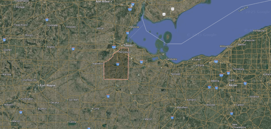
Wood County is positioned in northwestern Ohio, just south of Toledo and along the western edge of Lake Erie. It is bordered by Lucas County to the north, Hancock County to the south, and Sandusky County to the east, with Henry County lying to the west. Spanning more than 600 square miles, the county is characterized by fertile farmland, small river valleys, and growing suburban corridors.
Bowling Green, the county seat, anchors the region as home to Bowling Green State University. Other communities include Perrysburg to the north along the Maumee River and North Baltimore in the southern section. With its mix of agriculture, higher education, and suburban expansion, Wood County ties together rural heritage and modern development.
#7. Medina County, Ohio
– Overall Rank: 248
– Population: 182,347
– Median household income: $89,968
– Median home value: $249,700 (80% own)
– Median rent: $1,053 (20% rent)
– Top public schools: Granger Elementary School (grade A), Hinckley Elementary School (grade A), Sharon Elementary School (grade A)
– Top private schools: St. Francis Xavier School (grade A), Medina Christian Academy (grade B minus), Saint Ambrose Catholic School (grade unavailable)
– Top places: Wadsworth (grade A), Medina (grade A minus), Brunswick (grade B+)

About
Medina County, Ohio rests between rural farmland and the influence of the Cleveland metropolitan area, giving it both small-town charm and suburban growth. The city of Medina, the county seat, is known for its historic square, cultural institutions, and role as a community anchor. Surrounding towns and countryside preserve agricultural traditions while accommodating steady development.
Residents celebrate local pride through fairs, parades, and seasonal festivals that strengthen social bonds. Parks, trails, and natural areas provide opportunities for recreation and connection to the land. Medina County remains a place where history, rural identity, and modern growth come together in enduring form.
Where is Medina County?
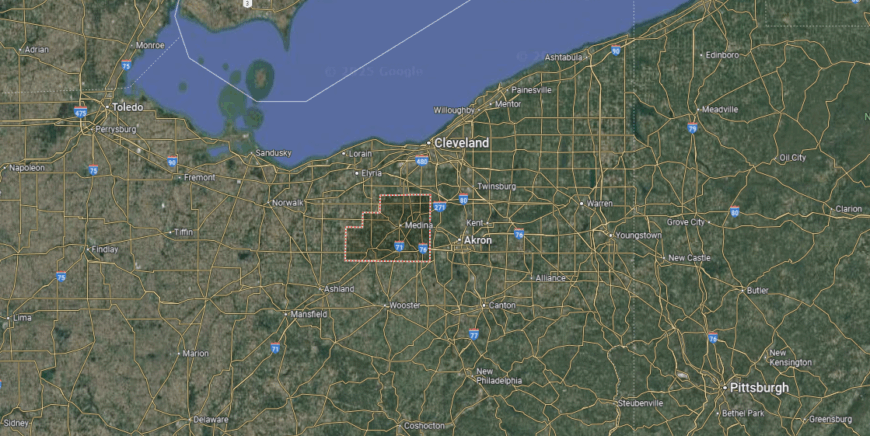
Medina County is located in northeastern Ohio, positioned between the Cleveland and Akron metropolitan areas. It is bordered by Lorain County to the west, Summit County to the east, and Wayne County to the south, while Cuyahoga County lies directly to the north. Covering about 425 square miles, the county blends suburban growth with stretches of farmland and wooded areas.
The city of Medina, serving as the county seat, sits near the center and is known for its historic downtown square. Other communities include Brunswick in the north and Wadsworth to the southeast, both of which have grown as suburban centers. With its mix of rural landscapes, historic towns, and modern development, Medina County bridges traditional character with metropolitan influence.
#6. Greene County, Ohio
– Overall Rank: 183
– Population: 167,567
– Median household income: $81,243
– Median home value: $222,300 (67% own)
– Median rent: $1,027 (33% rent)
– Top public schools: Bellbrook High School (grade A), Bellbrook Middle School (grade A), Trebein Elementary School (grade A)
– Top private schools: Legacy Christian Academy (grade A minus), Wright State University Mini University (grade A), St. Luke Catholic Elementary School (grade unavailable)
– Top places: Yellow Springs (grade A+), Bellbrook (grade A+), Beavercreek (grade A+)
You may also like: Counties with the highest heart disease rates in Ohio
About
Greene County, Ohio is set in the Miami Valley, where farmland, towns, and a strong educational presence define its character. The city of Xenia, the county seat, anchors civic life with historic roots and a role as a regional hub. Surrounding communities, including Fairborn and Yellow Springs, add unique identities shaped by military ties, universities, and artistic traditions.
Residents gather through cultural festivals, fairs, and school events that highlight both heritage and creativity. Parks, bike trails, and natural areas connect people to the land and foster outdoor activity. Greene County stands as a place where history, education, and community spirit come together in lasting balance.
Where is Greene County?
Greene County is located in southwestern Ohio, within the Miami Valley. It is bordered by Clark County to the north, Madison and Fayette counties to the northeast, and Clinton County to the southeast, with Warren and Montgomery counties along its southern and western edges. The county spans about 420 square miles of farmland, wooded areas, and suburban development.
Xenia, the county seat, lies near the center as a civic and transportation hub. Other key communities include Beavercreek to the west, Fairborn adjacent to Wright-Patterson Air Force Base, and Yellow Springs to the north. Greene County blends suburban expansion with historic towns and rural landscapes, tying together the Dayton metro area with Ohio’s agricultural core.
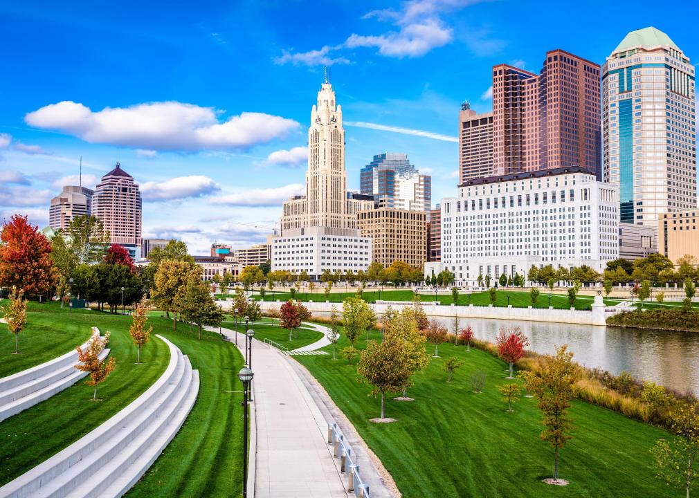
#5. Franklin County, Ohio
– Overall Rank: 159
– Population: 1,318,149
– Median household income: $71,070
– Median home value: $243,100 (53% own)
– Median rent: $1,169 (47% rent)
– Top public schools: Wyandot Elementary School (grade A+), Henry Karrer Middle School (grade A+), Mary Emma Bailey Elementary School (grade A+)
– Top private schools: Columbus Academy (grade A+), The Wellington School (grade A+), Columbus School for Girls (grade A+)
– Top places: Bexley (grade A+), Upper Arlington (grade A+), Dublin (grade A+)

About
Franklin County, Ohio is the state’s capital region, anchored by Columbus, which serves as both the county seat and Ohio’s largest city. The area reflects a blend of government, education, commerce, and culture, with a history shaped by growth along the Scioto and Olentangy Rivers. Surrounding suburbs and neighborhoods add diversity, balancing urban energy with community-centered living.
Residents experience a vibrant cultural life through festivals, sports, museums, and university events that highlight both tradition and innovation. Parks, trails, and riverfront spaces offer recreation and connect people to the natural landscape. Franklin County endures as a place where history, progress, and civic pride converge in dynamic form.
Where is Franklin County?
Franklin County lies in central Ohio and serves as the state’s most populous county. It is bordered by Delaware County to the north, Fairfield and Licking counties to the east, and Madison and Pickaway counties to the west and south. Spanning about 540 square miles, the county features a mix of urban development, river valleys, and suburban communities.
Columbus, the state capital and county seat, dominates the region as its cultural and economic center. Other communities include Dublin, Westerville, and Grove City, each part of the greater metropolitan area. With government, education, business, and technology at its core, Franklin County anchors Ohio’s growth and identity.
#4. Summit County, Ohio
– Overall Rank: 115
– Population: 539,361
– Median household income: $68,360
– Median home value: $182,500 (67% own)
– Median rent: $956 (33% rent)
– Top public schools: Hudson High School (grade A+), Hudson Middle School (grade A), East Woods Elementary School (grade A)
– Top private schools: Western Reserve Academy (grade A+), Archbishop Hoban High School (grade A), Our Lady of the Elms (grade A)
– Top places: Hudson (grade A+), Fairlawn (grade A+), Reminderville (grade A)
About
Summit County, Ohio rises in the state’s northeast, its name drawn from the highest elevation along the Ohio and Erie Canal. The city of Akron, the county seat, reflects a history built on rubber and tire manufacturing while today standing as a center for culture, education, and innovation. Smaller towns and suburban communities add balance, preserving local traditions while contributing to steady growth.
Community pride shows through festivals, concerts, and civic events that connect residents across generations. Outdoor recreation thrives in the Cuyahoga Valley National Park, Metro Parks, and along historic canalways that tie the county to its past. Summit County remains a place where industry, heritage, and natural beauty come together in lasting form.
Where is Summit County?
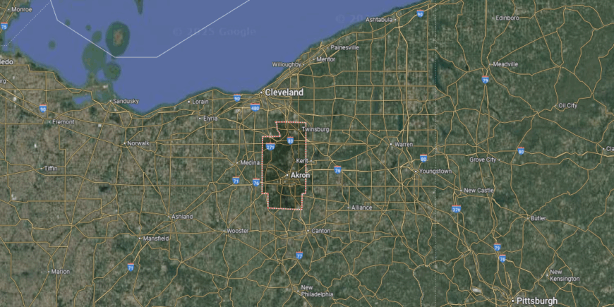
Summit County is located in northeastern Ohio, within the state’s Western Reserve region. It is bordered by Cuyahoga County to the north, Stark County to the south, and Portage and Medina counties to the east and west. Covering about 420 square miles, the county combines rolling hills, river valleys, and densely developed urban corridors.
Akron, the county seat and largest city, anchors the region with its industrial heritage and cultural institutions. Other communities include Cuyahoga Falls, Barberton, and Hudson, each adding suburban or historic character. With the Cuyahoga Valley National Park along its northern edge, Summit County blends natural landscapes with urban life.
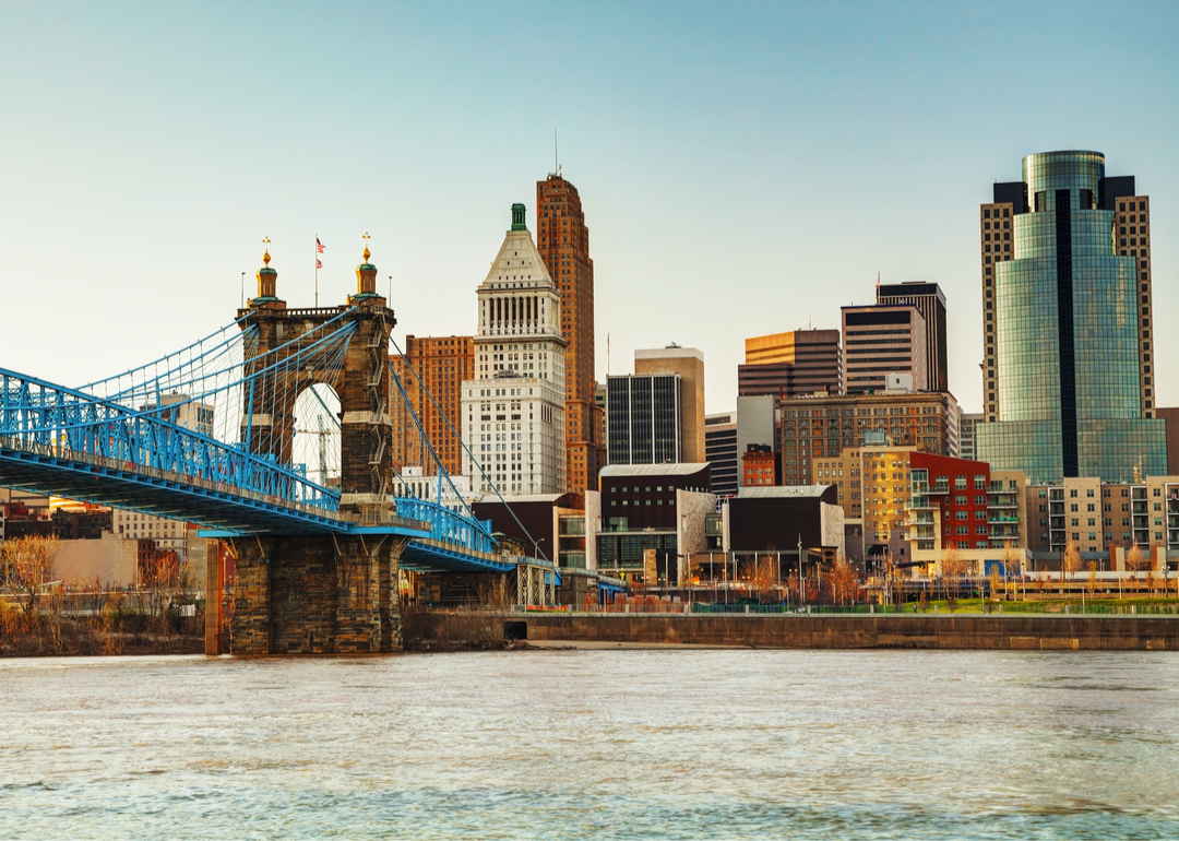
#3. Hamilton County, Ohio
– Overall Rank: 114
– Population: 827,671
– Median household income: $68,249
– Median home value: $205,000 (59% own)
– Median rent: $961 (41% rent)
– Top public schools: Indian Hill High School (grade A+), Sycamore High School (grade A+), Mariemont Junior High School (grade A+)
– Top private schools: Cincinnati Country Day School (grade A+), The Seven Hills School (grade A+), The Summit Country Day School (grade A+)
– Top places: Blue Ash (grade A+), Mariemont (grade A+), Madeira (grade A+)
About
Hamilton County, Ohio sits along the Ohio River, where history, commerce, and culture have long shaped its identity. The city of Cincinnati, the county seat, anchors the region with its historic neighborhoods, vibrant arts scene, and legacy in trade and industry. Surrounding towns and suburbs reflect a mix of tradition and modern growth tied to the metropolitan area.
Residents gather through parades, festivals, and cultural events that highlight both heritage and creativity. Parks, riverfront trails, and nearby hills provide recreation while linking people to the natural setting. Hamilton County stands as a place where history, innovation, and community spirit remain central to daily life.
Where is Hamilton County?
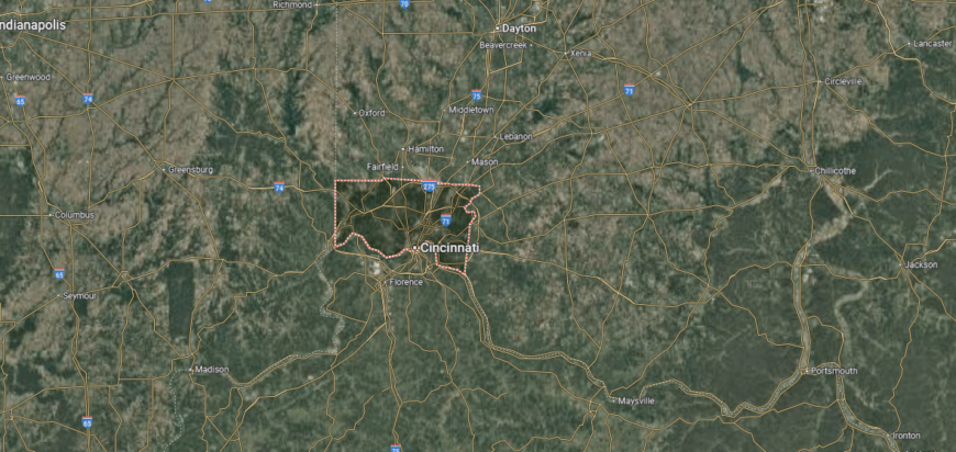
Hamilton County is set in the southwestern corner of Ohio, along the banks of the Ohio River. It is bordered by Butler County to the north, Clermont County to the east, and Warren County to the northeast, while Kentucky lies directly across the river to the south. Spanning about 410 square miles, the county blends urban density with suburban and riverfront areas.
Cincinnati, the county seat and largest city, dominates the region as a center of culture, commerce, and history. Other communities include Norwood, Blue Ash, and Forest Park, each contributing to the metropolitan mix. With its riverfront setting, historic neighborhoods, and economic importance, Hamilton County anchors southwestern Ohio.
#2. Warren County, Ohio
– Overall Rank: 87
– Population: 243,189
– Median household income: $103,128
– Median home value: $290,900 (79% own)
– Median rent: $1,254 (21% rent)
– Top public schools: William Mason High School (grade A+), Mason Intermediate Elementary School (grade A), Mason Middle School (grade A)
– Top private schools: Liberty Bible Academy (grade A), The CinDay Academy (grade A), Royalmont Academy (grade A)
– Top places: Mason (grade A+), Landen (grade A+), Springboro (grade A)
About
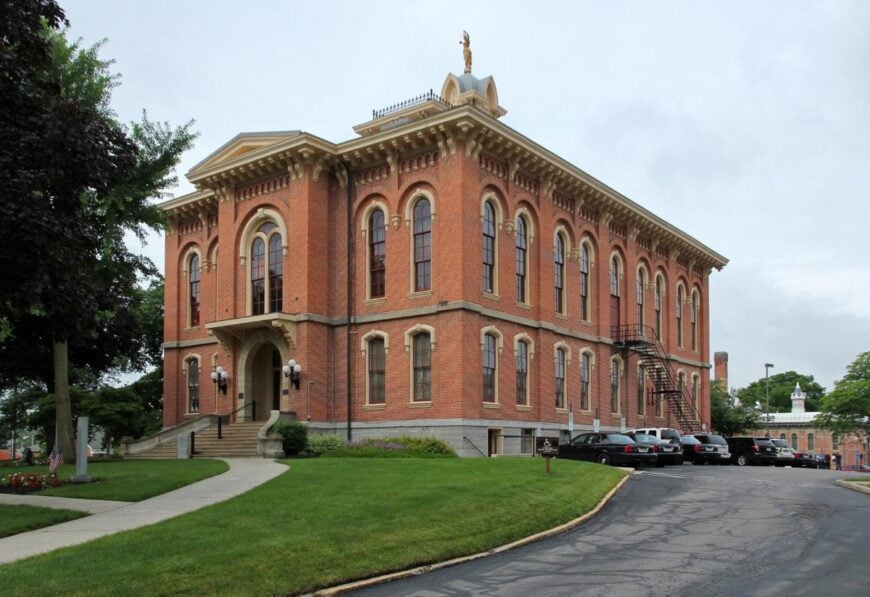
Warren County, Ohio is often called the “Ohio’s Largest Playground,” reflecting its blend of history, recreation, and steady growth. The city of Lebanon, the county seat, anchors community life with its historic downtown and cultural landmarks. Surrounding towns and suburban areas connect rural traditions with modern development tied to the Cincinnati-Dayton corridor.
Local spirit is showcased through fairs, festivals, and family-centered events that highlight both heritage and community pride. Outdoor recreation thrives at state parks, rivers, and attractions like Kings Island, drawing both residents and visitors. Warren County endures as a place where tradition, leisure, and growth come together in lasting form.
Where is Warren County?
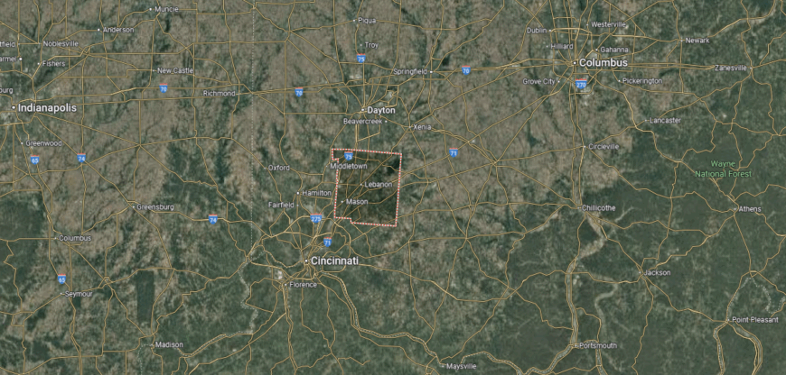
Warren County is located in southwestern Ohio, positioned between Cincinnati and Dayton. It is bordered by Montgomery County to the north, Clermont County to the south, and Butler County to the west, with Clinton and Greene counties along its eastern edge. The county spans nearly 400 square miles, featuring rolling farmland, river valleys, and fast-growing suburban areas.
Lebanon, the county seat, lies near the center and is noted for its historic downtown. Other communities include Mason, one of the county’s largest cities, and Springboro along the northern border. With attractions like Kings Island, the Little Miami River, and strong residential growth, Warren County blends history, recreation, and suburban development.
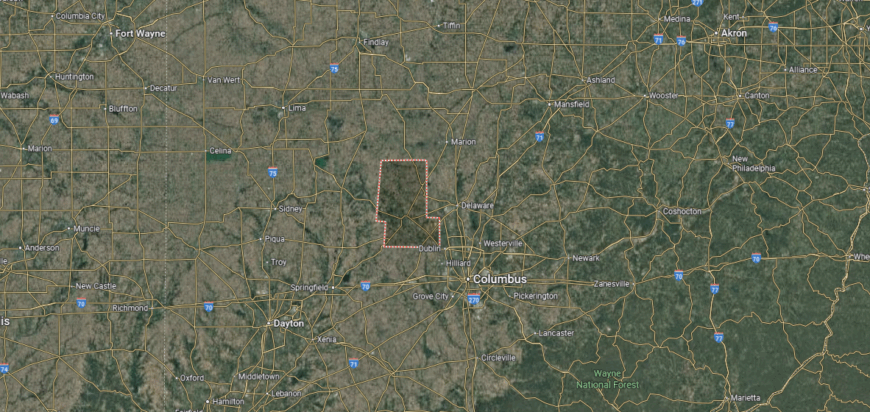
#1. Delaware County, Ohio
– Overall Rank: 50
– Population: 216,074
– Median household income: $123,995
– Median home value: $393,000 (79% own)
– Median rent: $1,338 (21% rent)
– Top public schools: Deer Run Elementary School (grade A+), Willard Grizzell Middle School (grade A+), Olentangy High School (grade A+)
– Top private schools: Genoa Christian Academy (grade B+), Delaware Christian School (grade B minus), St. Paul School (grade unavailable)
– Top places: Powell (grade A+), Delaware (grade A minus), Galena (grade A minus)
About
Delaware County, Ohio reflects one of the fastest-growing regions in the state, where suburban expansion meets a strong sense of history. The city of Delaware, the county seat, preserves a lively downtown, cultural institutions, and ties to Ohio Wesleyan University. Beyond its urban core, farmland, trails, and rural towns keep the county connected to its roots.
Community pride is expressed through festivals, parades, and school-centered traditions that bring neighbors together. Alum Creek, Hoover Reservoir, and numerous parks provide recreation and connect residents to the outdoors. Delaware County stands as a place where rapid growth and deep heritage come together in balanced form.
Where is Delaware County?
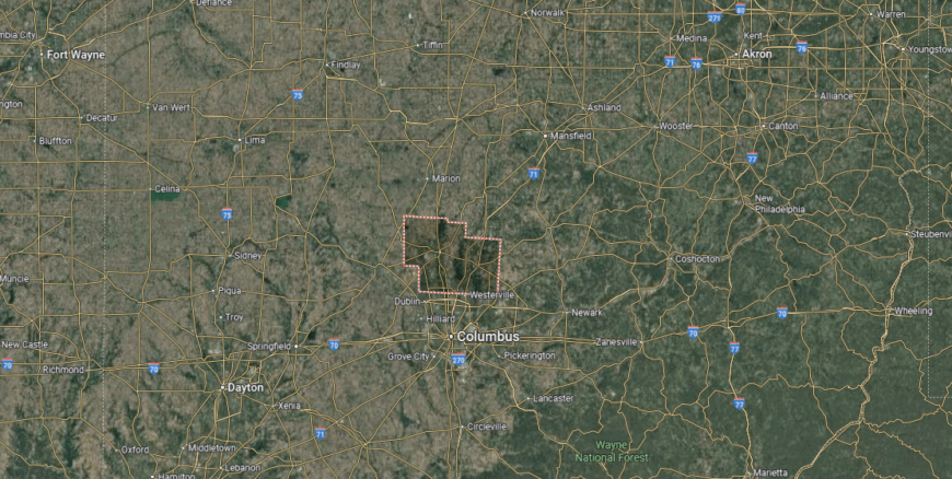
Delaware County is in central Ohio, just north of Columbus. It is bordered by Morrow County to the north, Licking County to the east, and Union County to the west, with Franklin County forming its southern edge. Spanning about 450 square miles, the county features rolling farmland, suburban growth, and the Olentangy River valley.
Delaware, the county seat, sits near the center and is home to Ohio Wesleyan University. Other communities include Powell, Sunbury, and Lewis Center, all tied to the county’s rapid suburban expansion. With its mix of historic towns, educational presence, and fast-paced development, Delaware County ranks among the state’s fastest-growing regions.
This story features data reporting and writing by Elena Cox and is part of a series utilizing data automation across 50 states.
You may also like: Risky reservoirs: Ohio counties where aging dams pose the greatest threat
By Stacker