
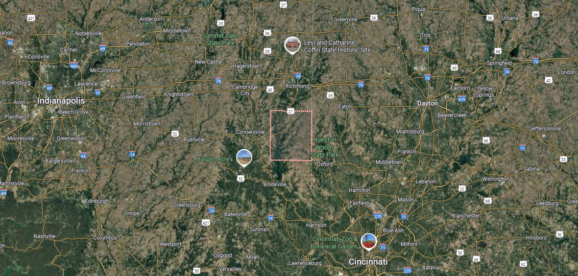
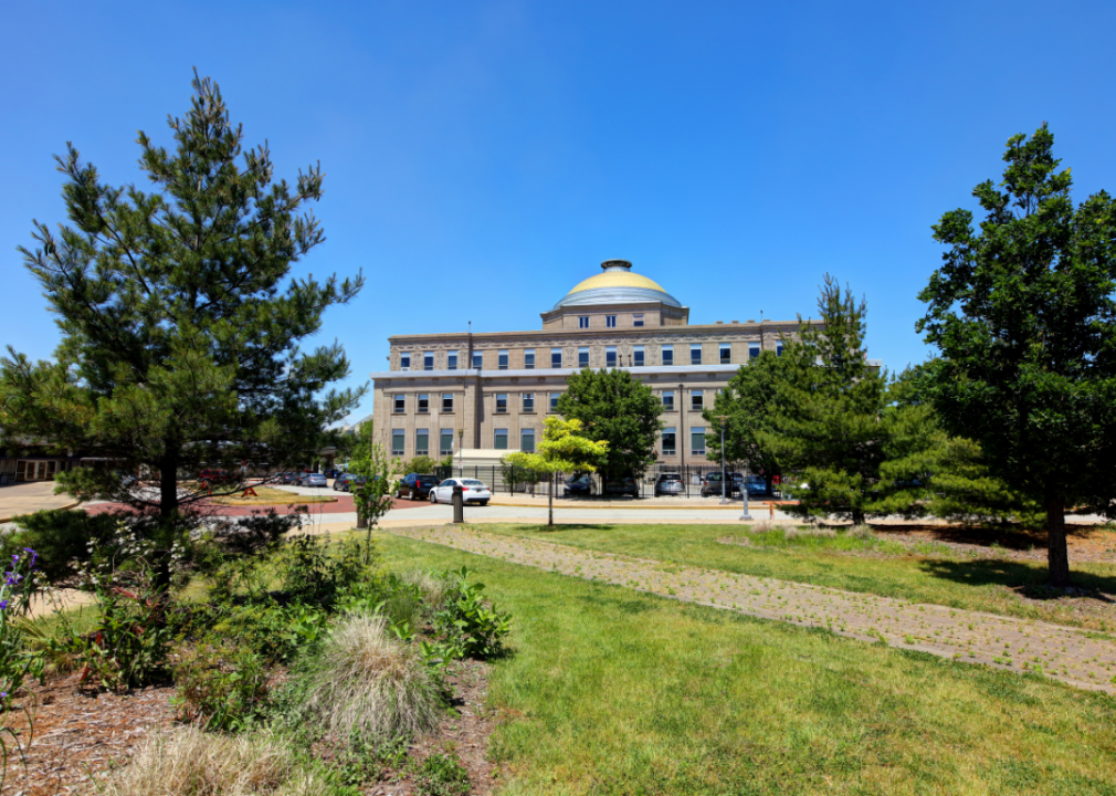
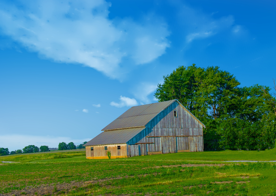
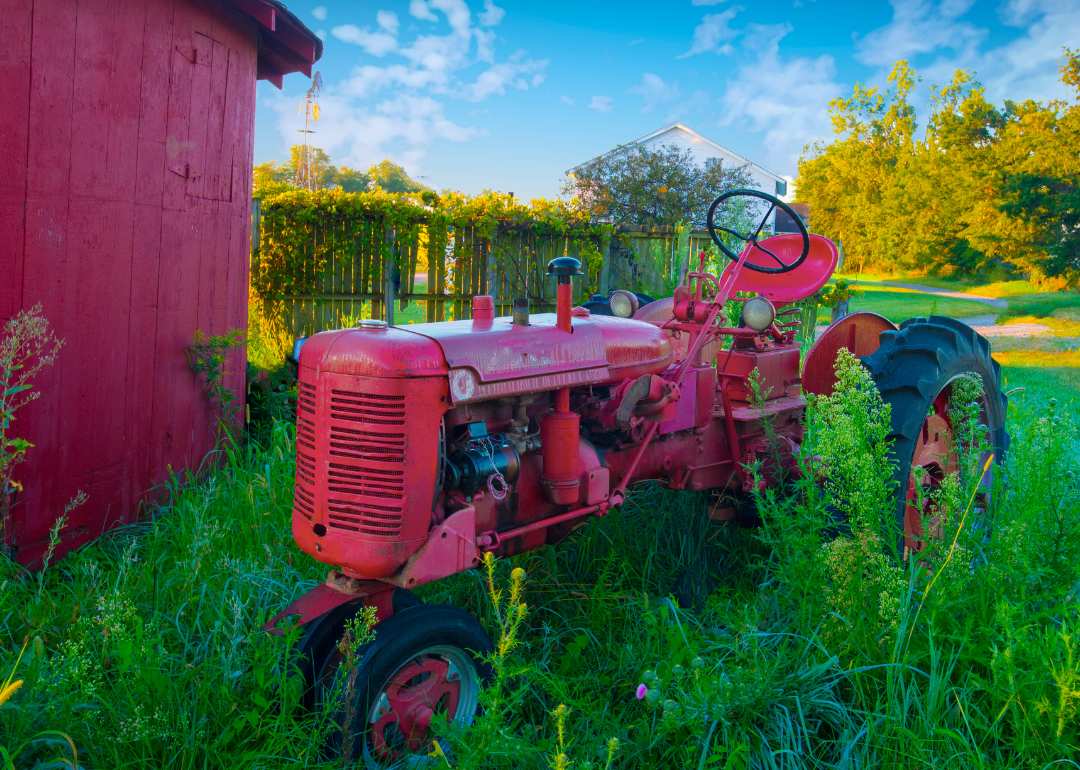
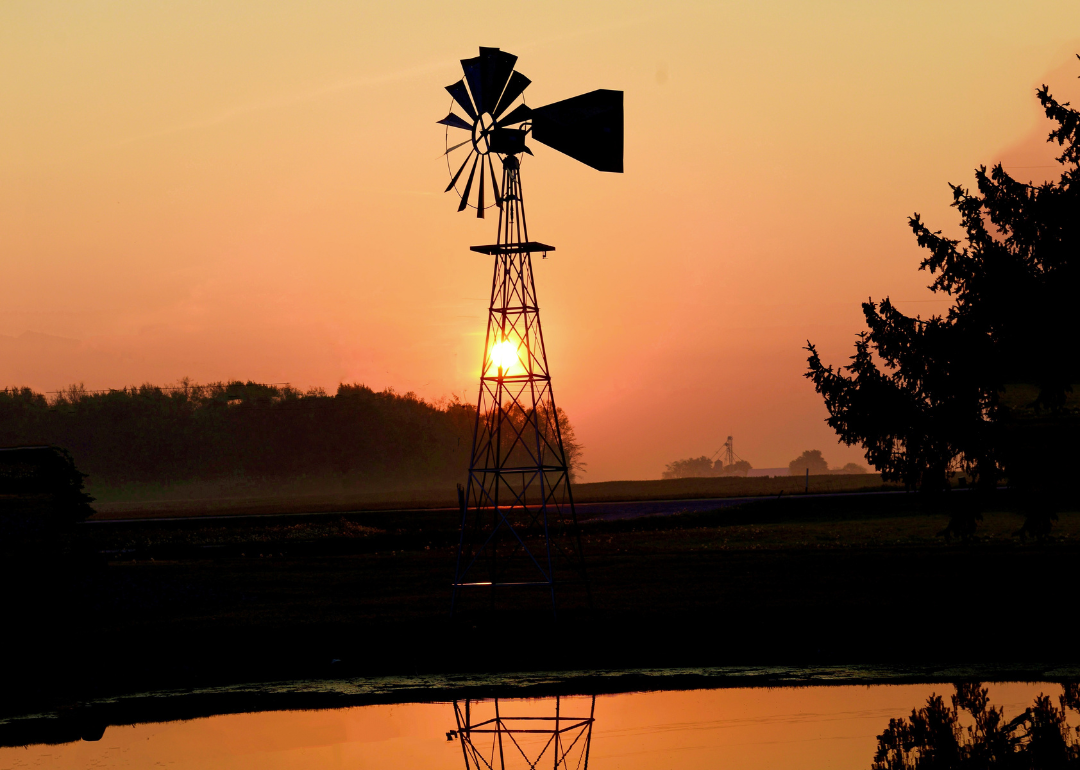
Counties with the shortest life expectancy in Indiana
Life expectancy can be affected by a variety of factors. About 25% of your lifespan is determined by genetics, according to the National Library of Medicine. Health and wellness habits—like following a balanced, nutrient-rich diet; not smoking; drinking minimal alcohol; maintaining a healthy weight; and staying physically active—can add more than a decade to your life, research from the National Institutes of Health shows. While these factors are significant, another important element that you might not have considered is your environment and community.
In order to come up with the very specific design ideas, we create most designs with the assistance of state-of-the-art AI interior design software. Also, assume links that take you off the site are affiliate links such as links to Amazon. this means we may earn a commission if you buy something.
While life expectancy generally increases annually in the United States—jumping from about 70.8 years old to 77.5 between 1970 and 2022, according to the Centers for Disease Control and Prevention—this particular metric can vary from state to state or even county to county. In some parts of the country, the average lifespan is getting shorter based on a variety of risk factors on top of health, including socioeconomic factors like poverty, unemployment, income, and education.
According to a 2020 study from researchers at Penn State, West Virginia, and Michigan State Universities, communities with a higher population density, more fast food restaurants, and a high number of extraction industry-based jobs tend to have shorter life expectancies.
To find out how life expectancy varies within Indiana, Stacker used 2024 County Health Rankings & Roadmaps from the University of Wisconsin Population Health Institute to identify the counties with the shortest life expectancy. Life expectancy measures the average number of years from birth a person can expect to live and is calculated based on the number of deaths in a given time period and the average number of people at risk of dying during that period. Counties with unreliable or insufficient data were excluded from the analysis. Mortality data came from the National Vital Statistics System.
Read on to see if your county is on the list.
You may also like: How gas prices have changed in Indiana in the last week
#46. Union County (tie)
– Life expectancy: 75.5 years
— 0.1 years lower than the state average
About
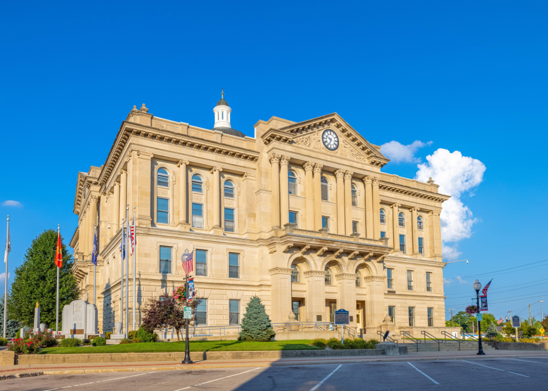
#45. St. Joseph County (tie)
– Life expectancy: 75.5 years
— 0.1 years lower than the state average
About
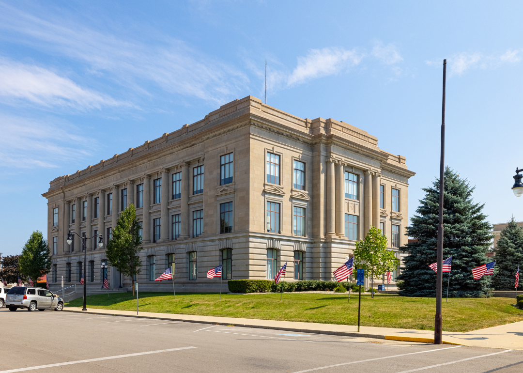
St. Joseph County, Indiana blends a strong industrial and educational legacy with the energy of urban and rural life. The city of South Bend, the county seat, is known for its ties to the Studebaker industry, revitalized downtown, and the presence of the University of Notre Dame. Smaller towns and surrounding farmland preserve a balance of tradition while contributing to the county’s diverse economy.
Community pride is expressed through festivals, cultural events, and school-centered traditions that unite residents. Outdoor opportunities thrive along the St. Joseph River, in county parks, and through trails that connect neighborhoods to nature. St. Joseph County endures as a place where history, innovation, and community identity continue to shape everyday living.
Where is St. Joseph County?
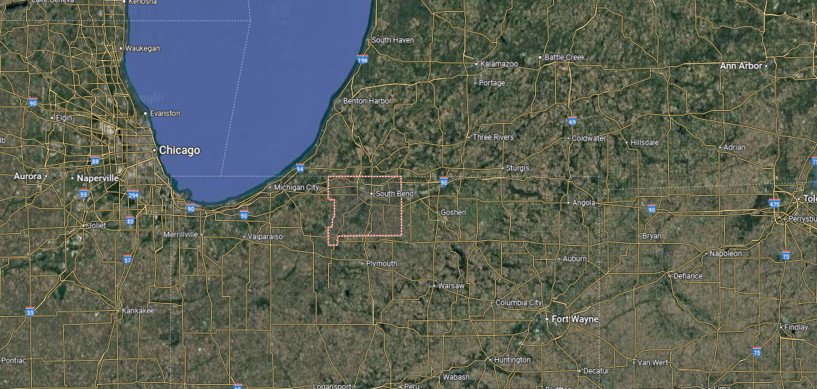
St. Joseph County is in northern Indiana, along the state’s border with Michigan. It is bordered by LaPorte County to the west, Elkhart County to the east, and Marshall County to the south, with Berrien and Cass counties in Michigan directly to the north. Spanning more than 450 square miles, the county features a mix of urban centers, farmland, and river valleys shaped by the St. Joseph River.
South Bend, the county seat and largest city, anchors the region as a hub of industry, education, and culture. Mishawaka, just to the east, adds to the metropolitan core, while smaller towns like New Carlisle and North Liberty highlight the county’s rural side. With the University of Notre Dame, manufacturing heritage, and a growing urban presence, St. Joseph County stands as one of northern Indiana’s most dynamic regions.
#44. White County (tie)
– Life expectancy: 75.4 years
— 0.2 years lower than the state average
About
White County, Indiana reflects a blend of farmland tradition and lakeside recreation that defines its rhythm of life. Monticello, the county seat, serves as the hub of civic and cultural activity, with nearby Lake Shafer and Lake Freeman drawing residents and visitors alike. Agriculture continues to anchor the economy, supported by small businesses and local institutions.
Seasonal festivals, county fairs, and school events highlight the spirit of community across towns and villages. The lakes and surrounding countryside provide opportunities for boating, fishing, and outdoor gatherings that connect people to the land. White County endures as a place where rural roots and recreational life exist side by side.
Where is White County?
White County is located in northwestern Indiana, bordered by Jasper County to the west, Carroll County to the south, and Pulaski County to the north. It spans about 500 square miles, with a landscape dominated by farmland, small lakes, and stretches of the Tippecanoe River. The county is well known for its mix of agriculture and recreation.
Monticello, the county seat, lies near the center and is a gateway to Lake Shafer and Lake Freeman. Other communities include Brookston in the south and Wolcott to the west, each reflecting the county’s rural roots. With its lakes, campgrounds, and agricultural base, White County blends small-town living with outdoor attractions.
#43. Huntington County (tie)
– Life expectancy: 75.4 years
— 0.2 years lower than the state average
About
Huntington County, Indiana is set in the state’s northeast, where rolling farmland and historic towns shape its identity. The city of Huntington, the county seat, reflects a legacy of industry and education while preserving landmarks tied to its past. Agriculture and small manufacturing remain central, blending tradition with steady economic life.
Community spirit thrives through fairs, cultural festivals, and school-centered gatherings that bring residents together. Parks, lakes, and trails across the county provide recreation and highlight the area’s natural beauty. Huntington County stands as a place where heritage, resilience, and community pride continue to define daily living.
Where is Huntington County?
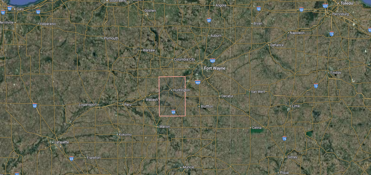
Huntington County is set in northeastern Indiana, bordered by Whitley County to the north, Wells County to the east, and Wabash County to the west. It covers about 380 square miles of rolling farmland, river valleys, and wooded areas. The Wabash and Little Rivers help define the county’s natural landscape.
Huntington, the county seat, lies near the center and serves as both the largest city and commercial hub. Other towns include Markle on the eastern edge and Roanoke in the northeast, each with strong community ties. With its agricultural foundation, small towns, and river scenery, Huntington County reflects a balance of rural life and local industry.
#42. Rush County (tie)
– Life expectancy: 75.4 years
— 0.2 years lower than the state average
You may also like: Highest-rated things to do in Indiana, according to Tripadvisor
About
Rush County, Indiana rests in the state’s east-central region, where wide stretches of farmland and rural towns define its landscape. The city of Rushville, the county seat, anchors civic life with a courthouse square and traditions rooted in agriculture and local industry. Generations have maintained a strong connection to the land, shaping both the economy and community identity.
Residents gather at county fairs, parades, and seasonal festivals that highlight rural heritage and foster pride. Outdoor recreation in parks, along rivers, and across open fields keeps people closely tied to nature. Rush County endures as a place where farming traditions, small-town life, and community spirit remain central to daily living.
Where is Rush County?
Rush County is located in east-central Indiana, bordered by Henry County to the north, Fayette County to the east, and Shelby County to the west. It spans nearly 410 square miles, with terrain made up of fertile farmland and gently rolling plains. Agriculture has long been the foundation of the county’s landscape and economy.
Rushville, the county seat, sits near the center and serves as the hub of government and commerce. Smaller towns include Carthage in the northwest and Arlington in the west, both rooted in farming communities. With its rural setting and historic county seat, Rush County highlights Indiana’s agricultural heartland.
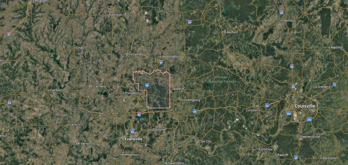
#41. Pike County (tie)
– Life expectancy: 75.4 years
— 0.2 years lower than the state average
About
Pike County, Indiana lies in the southwestern part of the state, where farmland, forests, and small towns give it a distinctly rural character. Petersburg, the county seat, anchors civic and cultural life while reflecting the county’s ties to agriculture and coal mining. Across the region, open landscapes and close-knit communities sustain a steady rhythm of local traditions.
Residents come together for fairs, festivals, and school events that highlight shared pride and heritage. Outdoor recreation along the White River, in county parks, and across woodlands keeps people connected to the land. Pike County stands as a place where natural resources, rural identity, and community life remain closely intertwined.
Where is Pike County?
🔥 Would you like to save this?
Pike County is located in southwestern Indiana, bordered by Daviess County to the north, Dubois County to the east, and Gibson and Warrick counties to the south, with Knox County on its western side. It covers about 340 square miles, marked by rolling farmland, coal fields, and river valleys tied to the White and Patoka rivers. Natural resources have played a strong role in shaping its identity.
Petersburg, the county seat, lies near the center and serves as the main hub of government and local business. Other small communities include Winslow and Spurgeon, each reflecting the county’s rural character. With its combination of agriculture, energy production, and waterways, Pike County blends Indiana’s farming traditions with industrial development.
#40. Clinton County
– Life expectancy: 75.3 years
— 0.3 years lower than the state average
About
Clinton County, Indiana grew from a strong agricultural foundation, where open fields and farmsteads still define much of its landscape. Frankfort, the county seat, carries the character of a classic Midwestern town with its courthouse square, industries, and local institutions. The county reflects a balance between rural heritage and the steady progress of small-town life.
Community identity comes alive in county fairs, school events, and gatherings that draw neighbors together year after year. Outdoor spaces, from local parks to trails that wind through farmland, provide recreation and connection to the land. Clinton County remains a place where tradition, resilience, and community spirit shape the rhythm of everyday living.
Where is Clinton County?
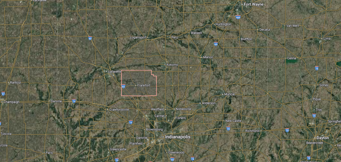
Clinton County is situated in central Indiana, bordered by Tippecanoe County to the west, Boone County to the south, and Howard County to the north. It spans just over 400 square miles, with flat farmland and small waterways making up most of the landscape. Agriculture is central to the county’s economy and character.
Frankfort, the county seat, sits near the center and serves as the largest community. Other towns include Rossville in the north and Mulberry to the west, each tied to the county’s rural traditions. With its farming base, small towns, and historic county seat, Clinton County reflects the heart of Indiana’s agricultural region.
#39. Switzerland County
– Life expectancy: 75.2 years
— 0.4 years lower than the state average
About
Switzerland County, Indiana rests along the Ohio River, where hills, valleys, and farmland create a landscape tied closely to both heritage and nature. Vevay, the county seat, reflects the county’s unique Swiss roots, with historic architecture and traditions carried forward from early settlers. Agriculture, river trade, and small-town life continue to guide the identity of the region.
Seasonal festivals, riverfront gatherings, and cultural events highlight local pride and celebrate the county’s history. Outdoor recreation thrives on the Ohio River, in state parks, and across rolling countryside that defines the area. Switzerland County stands as a place where heritage, natural beauty, and community connection remain firmly woven together.
Where is Switzerland County?
Switzerland County is tucked into the southeastern corner of Indiana, along the Ohio River. It is bordered by Ohio County to the east, Jefferson County to the west, and Ripley County to the north, while Kentucky lies just across the river to the south. Covering about 225 square miles, the county is defined by rolling hills, river bluffs, and farmland.
Vevay, the county seat, sits on the Ohio River and is known for its early Swiss settlers and winemaking heritage. Other small towns include Patriot and Florence, both riverfront communities. With its scenic views, historic ties, and riverside setting, Switzerland County blends rural charm with cultural tradition.
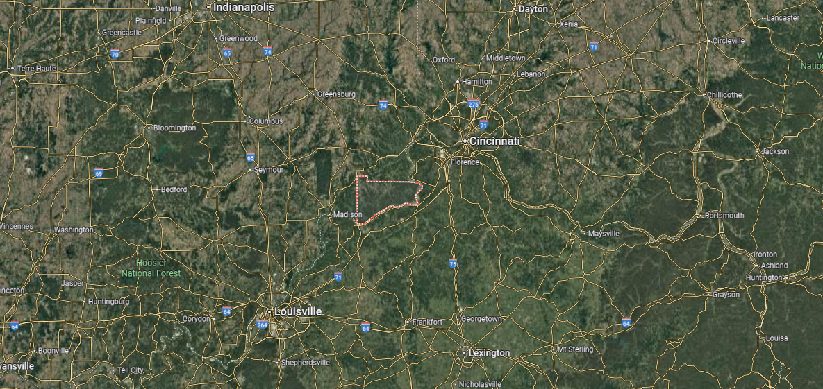
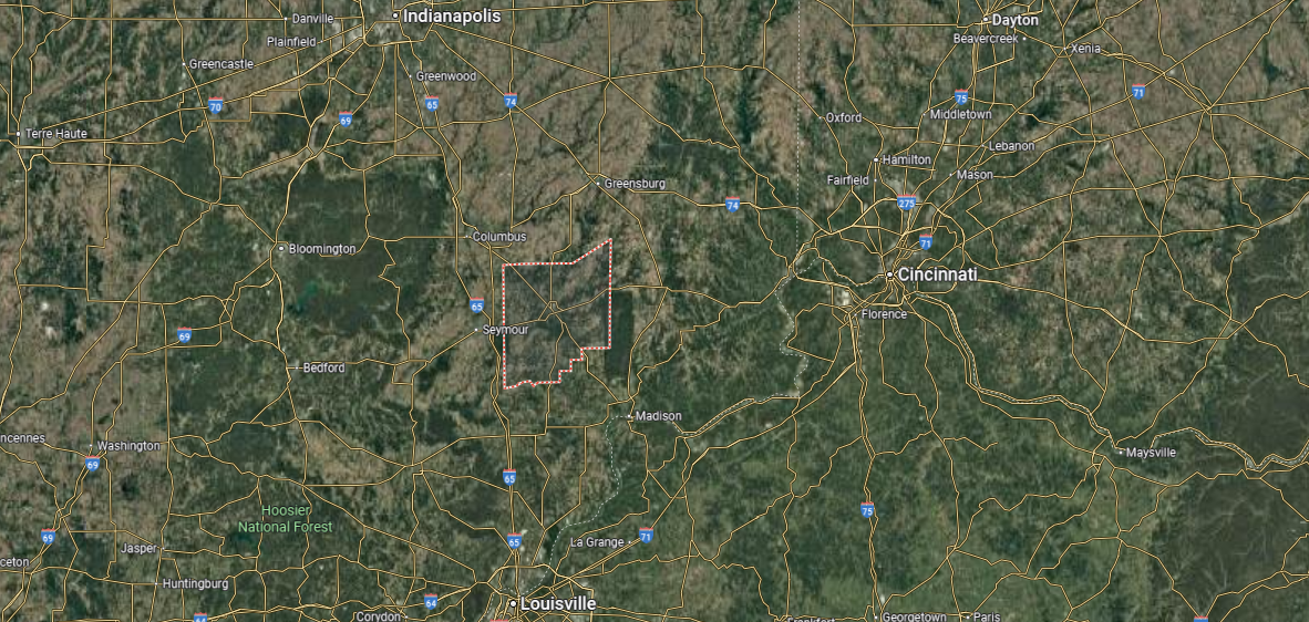
#38. Jackson County (tie)
– Life expectancy: 75.0 years
— 0.6 years lower than the state average
About
Jackson County, Indiana finds its character in the mix of small towns, farmland, and wooded hills that stretch across its landscape. Seymour, the largest city and county seat, developed as a railroad crossroads and remains central to the region’s culture and economy. Brownstown, along with other communities, adds layers of history and civic tradition.
Life here moves with the rhythm of county fairs, school gatherings, and music festivals that draw residents together. Natural spaces like Muscatatuck National Wildlife Refuge and nearby trails offer recreation and reflection. Jackson County stands as a place where daily life is shaped by community pride, local history, and the land itself.
Where is Jackson County?
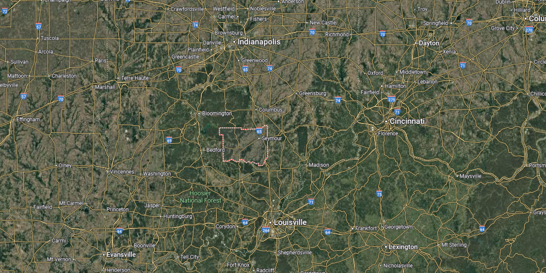
Jackson County is located in southern Indiana, bordered by Bartholomew County to the north, Jennings County to the east, and Washington and Lawrence counties to the south and west. It spans about 515 square miles, with terrain that includes river valleys, forested hills, and fertile farmland along the East Fork of the White River. Parts of the Hoosier National Forest extend into the county, adding natural variety.
Seymour, the county seat and largest city, lies near the center and serves as the county’s commercial hub. Brownstown, another key community, holds the historic courthouse and is rich in local heritage. With its mix of agriculture, industry, and outdoor recreation, Jackson County reflects both tradition and growth in southern Indiana.
#37. Jefferson County (tie)
– Life expectancy: 75.0 years
— 0.6 years lower than the state average
You may also like: How many people are receiving substance use treatment in Indiana
About
Jefferson County, Indiana sits along the Ohio River, where river towns, farmland, and wooded hills shape both its history and daily life. Madison, the county seat, is known for its well-preserved historic district, one of the largest of its kind in the Midwest, and for its strong ties to commerce along the river. Beyond the city, rural areas maintain traditions of farming and small-town community spirit.
Festivals, parades, and cultural events highlight the county’s heritage while drawing residents and visitors together. Outdoor recreation thrives along the Ohio River, in Clifty Falls State Park, and throughout the rolling countryside. Jefferson County endures as a place where history, landscape, and community life remain closely connected.
Where is Jefferson County?
Jefferson County is located in southeastern Indiana, along the Ohio River. It is bordered by Switzerland County to the east, Jennings County to the north, and Scott County to the west, with Kentucky just across the river to the south. Spanning nearly 365 square miles, the county features river valleys, wooded hills, and productive farmland.
Madison, the county seat, lies on the Ohio River and is noted for its historic downtown and riverfront setting. Smaller towns include Hanover, home to Hanover College, and Dupont in the northern part of the county. With its blend of history, education, and scenic landscapes, Jefferson County is a distinctive part of Indiana’s Ohio River region.
#36. Floyd County (tie)
– Life expectancy: 75.0 years
— 0.6 years lower than the state average
About
Floyd County, Indiana combines the vibrancy of a river city with the quiet character of its surrounding hills and farmland. New Albany, the county seat, has long been tied to the Ohio River, first as a steamboat center and now as a hub for culture, education, and business. Smaller towns and rural communities add balance, preserving traditions that keep the county’s heritage alive.
Residents gather at local fairs, parades, and concerts that strengthen bonds across generations. The Knobs, with their scenic views and trails, offer a natural escape and highlight the beauty of southern Indiana. Floyd County remains a place where history, landscape, and community spirit are woven into everyday life.
Where is Floyd County?
Floyd County is located in southern Indiana, directly across the Ohio River from Louisville, Kentucky. It is bordered by Clark County to the east, Harrison County to the west, and Washington County to the north. Covering less than 150 square miles, it is one of Indiana’s smallest counties, with a mix of wooded hills, farmland, and riverfront.
New Albany, the county seat, anchors Floyd County as its largest city and main commercial hub. Smaller towns such as Georgetown and Greenville highlight the county’s small-town character. With its historic neighborhoods, suburban growth, and strong ties to Louisville, Floyd County blends local tradition with metropolitan influence.
#35. Harrison County (tie)
– Life expectancy: 74.8 years
— 0.8 years lower than the state average
About
Harrison County, Indiana holds a unique place in the state’s story as the site of its first capital at Corydon. The county seat preserves that legacy with historic landmarks, courthouses, and cultural traditions that keep early Indiana history alive. Beyond Corydon, the county’s farmland, forests, and small towns reflect a steady rhythm of rural life.
Community pride shows through local festivals, heritage events, and school gatherings that bring residents together. Natural attractions like O’Bannon Woods State Park and the Ohio River provide recreation and connect people to the land. Harrison County endures as a place where history, landscape, and community values remain closely intertwined.
Where is Harrison County?
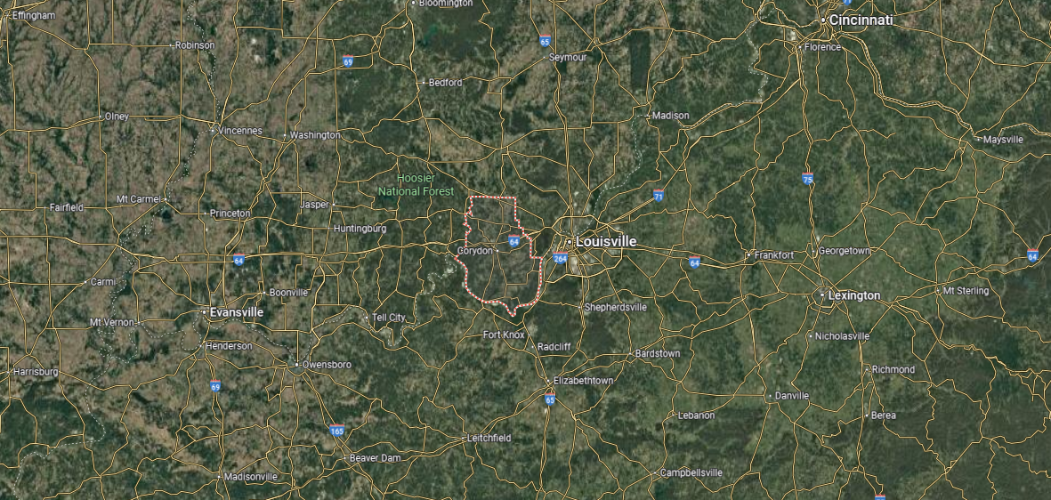
🔥 Would you like to save this?
Harrison County is in southern Indiana, along the Ohio River across from Kentucky. It is bordered by Floyd County to the east, Washington County to the north, and Crawford County to the west. Covering about 485 square miles, the county includes river lowlands, rolling hills, and large stretches of forest.
Corydon, the county seat, was Indiana’s first state capital and is known for its historic courthouse square. Other communities include Lanesville, Elizabeth, and Palmyra, each reflecting the county’s rural heritage. With its historic sites, scenic river views, and natural areas, Harrison County blends deep history with southern Indiana’s landscape.
#34. LaPorte County (tie)
– Life expectancy: 74.8 years
— 0.8 years lower than the state average
About
LaPorte County, Indiana finds its character in the mix of lakes, farmland, and shoreline along Lake Michigan. LaPorte, the county seat, serves as a historic and civic center, while Michigan City brings a stronger industrial and cultural presence to the region. Smaller towns and rural landscapes add depth, keeping agricultural traditions alive.
County life is expressed in seasonal fairs, community festivals, and local markets that draw residents together. Outdoor recreation ranges from hiking and boating to exploring the Indiana Dunes, tying people closely to the land and water. LaPorte County remains a place where heritage, natural resources, and community identity come together in lasting form.
Where is LaPorte County?
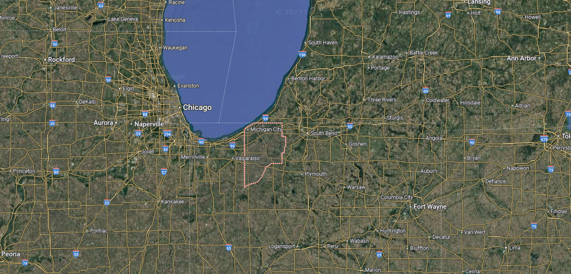
LaPorte County is located in northwestern Indiana, along the southern shore of Lake Michigan. It is bordered by Porter County to the west, St. Joseph County to the east, and Starke County to the south, while the lake defines its northern edge. Spanning over 600 square miles, it is one of Indiana’s larger counties, with landscapes ranging from farmland and forests to dunes and shoreline.
LaPorte, the county seat, lies inland near the center, while Michigan City sits on Lake Michigan as the largest community. Other towns include Westville, Kingsford Heights, and Trail Creek, each adding to the county’s mix of urban and rural life. With its lakefront, parks, and transportation links, LaPorte County ties natural beauty with industrial and commercial activity.
#33. Lake County (tie)
– Life expectancy: 74.7 years
— 0.9 years lower than the state average
About
Lake County, Indiana anchors the northwest corner of the state, where industry, commerce, and lakefront culture define its identity. Crown Point, the county seat, reflects historic charm with its courthouse square, while Gary stands as a symbol of the region’s industrial past and cultural influence. Suburban communities, farmland, and natural areas add contrast to the urban centers.
Life here is marked by neighborhood festivals, cultural events, and gatherings that highlight the county’s diversity. Outdoor opportunities stretch from the shores of Lake Michigan to the trails and dunes of Indiana Dunes National Park. Lake County stands as a place where history, resilience, and community spirit shape everyday life in a unique corner of Indiana.
Where is Lake County?
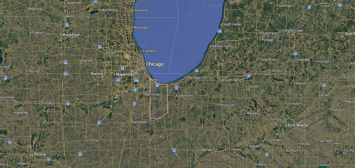
Lake County is positioned in the far northwestern corner of Indiana, along the southern shore of Lake Michigan. It is bordered by Porter County to the east, Newton and Jasper counties to the south, and Illinois to the west, with the lake forming its northern boundary. Spanning about 500 square miles, the county blends heavy industry, suburban growth, and natural lakefront areas.
Crown Point, the county seat, sits inland near the center, while Gary is the largest historic industrial city on the lakefront. Other major communities include Hammond, East Chicago, and Merrillville, each shaping the county’s metropolitan core. With its mix of steelmaking heritage, diverse cities, and access to Lake Michigan, Lake County stands as one of Indiana’s most urbanized and economically significant regions.
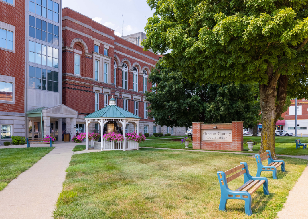
#32. Greene County (tie)
– Life expectancy: 74.7 years
— 0.9 years lower than the state average
You may also like: Demand for these health care jobs is increasing most in Indiana
About
Greene County, Indiana lies in the state’s southwest, where rolling farmland, forests, and small towns shape a distinctly rural way of life. Bloomfield, the county seat, serves as the hub of civic activity with its historic courthouse square and strong community traditions. Coal mining, agriculture, and small industry have long influenced the county’s economy and character.
Residents gather at county fairs, local festivals, and school events that strengthen ties across generations. Outdoor life is supported by state forests, reservoirs, and scenic trails that connect people to the land. Greene County remains a place where heritage, natural beauty, and community values are deeply rooted in daily living.
Where is Greene County?
Greene County is located in southwestern Indiana, bordered by Owen County to the north, Monroe County to the northeast, and Daviess and Martin counties to the south. It spans about 545 square miles, with a landscape of rolling farmland, forested hills, and river valleys, including stretches of the White River. Agriculture and natural resources have long shaped the county’s character.
Bloomfield, the county seat, lies near the center and serves as the hub of government and community life. Other towns include Linton, historically tied to coal mining, and Worthington along the White River. With its rural communities, natural landscapes, and historic industries, Greene County reflects the heart of southern Indiana.
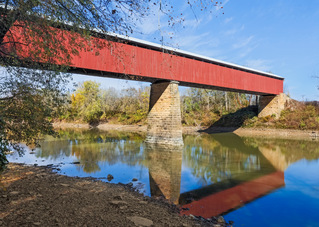
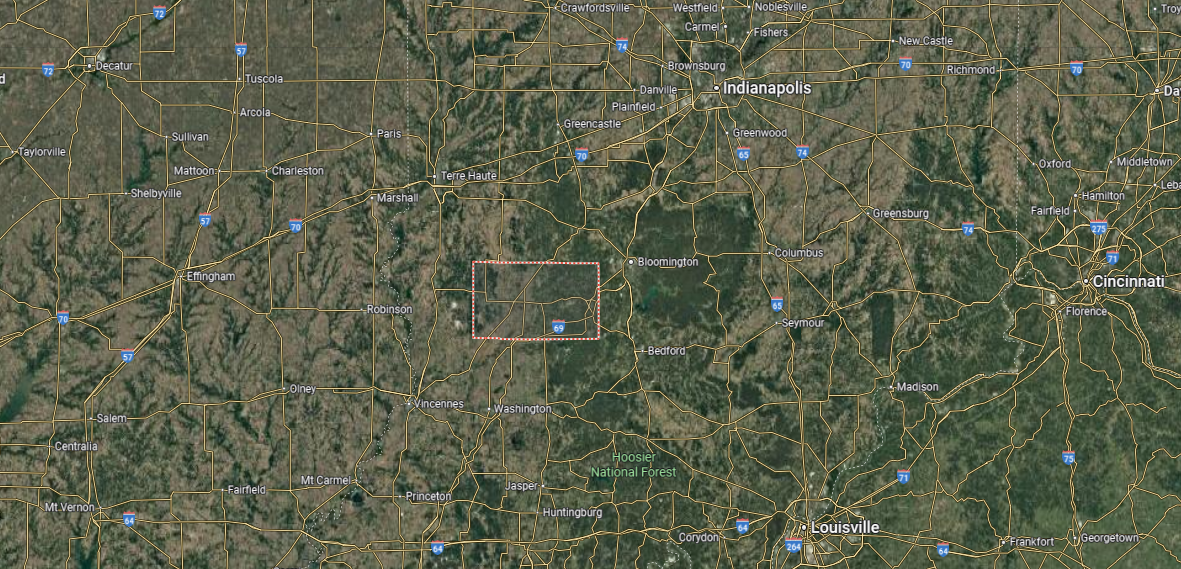
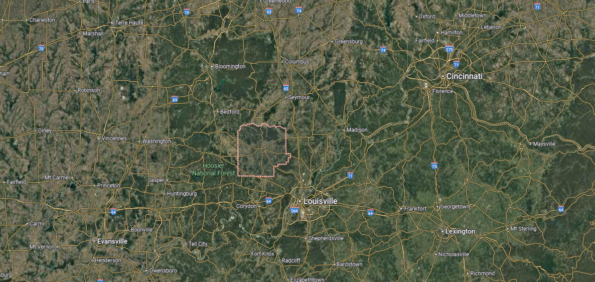
#31. Lawrence County (tie)
– Life expectancy: 74.6 years
— 1.0 years lower than the state average

About
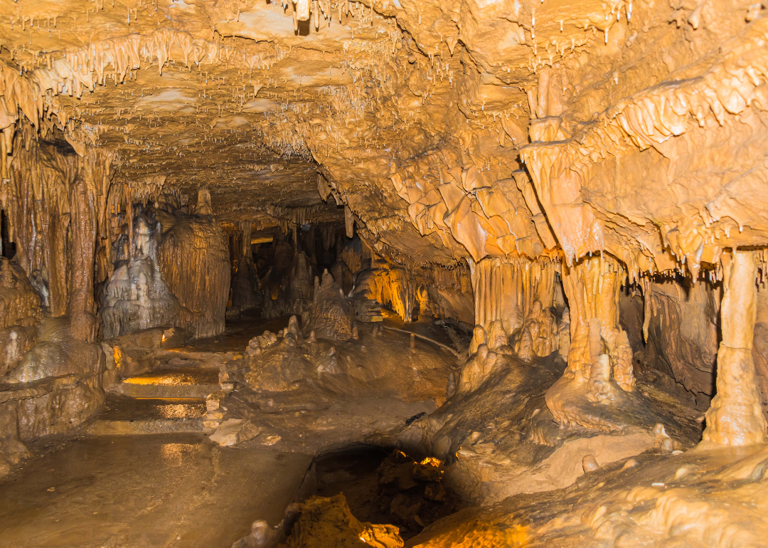
Lawrence County, Indiana rests in the state’s southern hills, long known for its limestone quarries that helped build landmarks across the nation. Bedford, the county seat, reflects this legacy with a strong industrial past and traditions that remain central to community identity. Mitchell and other towns add to the county’s character through small-town life and historic connections.
Local pride comes alive in festivals, parades, and school events that celebrate heritage and community ties. Outdoor recreation thrives in nearby caves, forests, and state parks that highlight the region’s natural beauty. Lawrence County stands as a place where industry, history, and rural traditions continue to shape everyday life.
Where is Lawrence County?
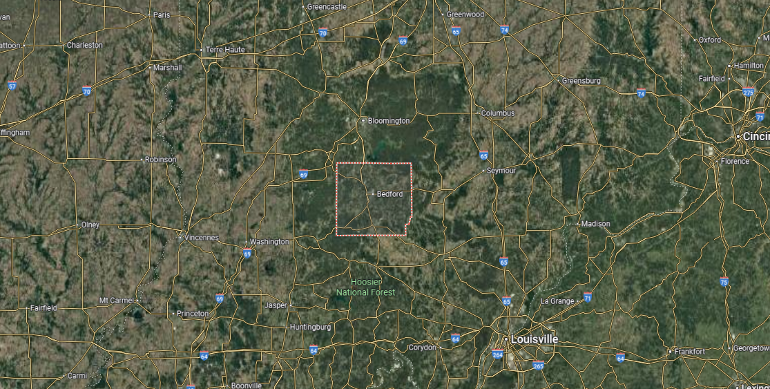
Lawrence County, Indiana rests in the state’s southern hills, long known for its limestone quarries that helped build landmarks across the nation. Bedford, the county seat, reflects this legacy with a strong industrial past and traditions that remain central to community identity. Mitchell and other towns add to the county’s character through small-town life and historic connections.
Local pride comes alive in festivals, parades, and school events that celebrate heritage and community ties. Outdoor recreation thrives in nearby caves, forests, and state parks that highlight the region’s natural beauty. Lawrence County stands as a place where industry, history, and rural traditions continue to shape everyday life.
#30. Vanderburgh County (tie)
– Life expectancy: 74.6 years
— 1.0 years lower than the state average
🔥 Would you like to save this?
About
Vanderburgh County, Indiana lies along the Ohio River, where urban life, industry, and culture intersect with a deep regional history. Evansville, the county seat and one of the state’s largest cities, anchors the area with its role as a center of commerce, education, and the arts. Surrounding neighborhoods and communities balance urban energy with a sense of tradition and local pride.
Residents celebrate their county through festivals, concerts, and civic events that reflect cultural diversity and community spirit. Outdoor recreation thrives along the riverfront, in city parks, and at nearby preserves that connect people to nature. Vanderburgh County endures as a place where history, growth, and community life come together in lasting form.
Where is Vanderburgh County?
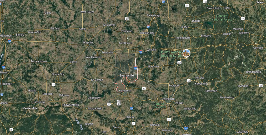
Vanderburgh County is located in the southwestern corner of Indiana, along the Ohio River. It is bordered by Posey County to the west, Warrick County to the east, and Gibson County to the north, while Kentucky lies just across the river to the south. Covering about 235 square miles, it is one of the smallest counties in land area but among the most densely populated in the state.
Evansville, the county seat and third-largest city in Indiana, dominates the region as a center of culture, health care, and industry. Smaller communities include Darmstadt in the north and Melody Hill near the city’s edge. With its riverfront setting, strong economy, and cultural institutions, Vanderburgh County serves as a hub for southwestern Indiana and beyond.
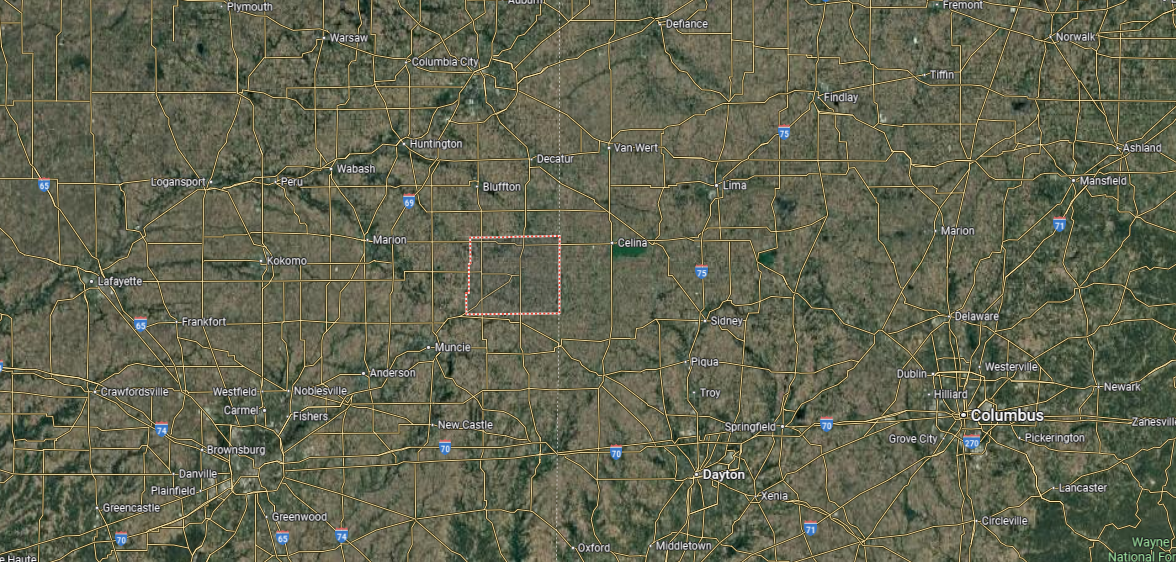
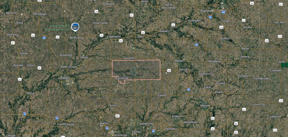
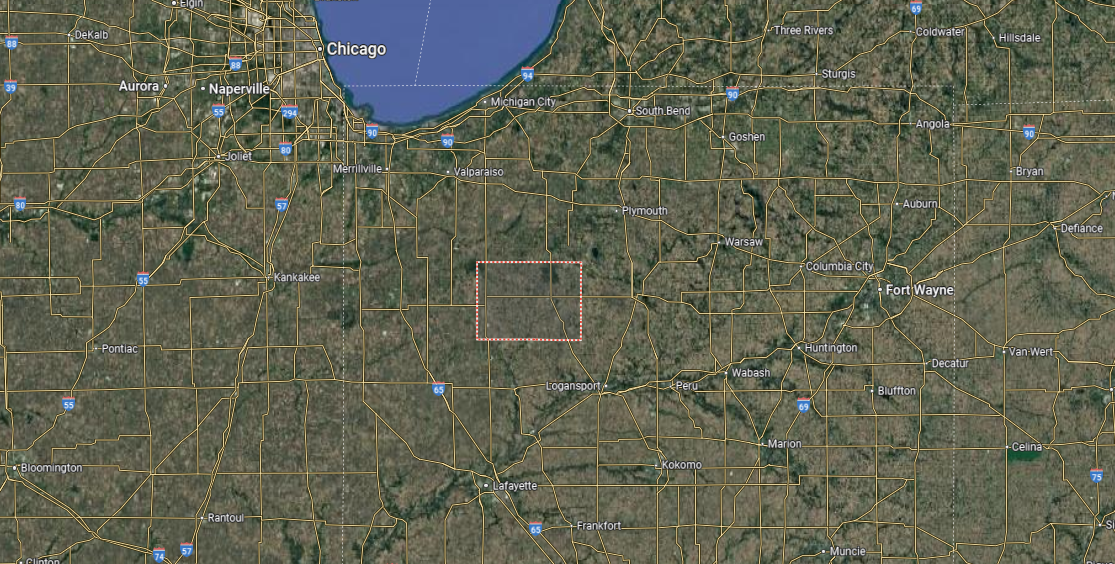
#29. Miami County (tie)
– Life expectancy: 74.5 years
— 1.1 years lower than the state average
About
Miami County, Indiana rests in north-central Indiana, where fields, forests, and river valleys shape a steady rural landscape. Peru, the county seat, grew with the Wabash and Erie Canal and railroads, later becoming famous for its circus heritage that still lives on today. Beyond the city, quiet towns and open farmland carry forward traditions tied to agriculture and community life.
People gather at local fairs, circus celebrations, and neighborhood events that bring generations together. The Wabash River, parks, and countryside trails provide outdoor spaces that connect residents to the land. Miami County stands as a place where history, natural setting, and community pride remain closely linked.
Where is Miami County?
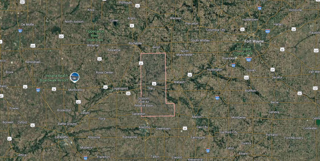
Miami County is in north-central Indiana, covering about 375 square miles of farmland, river valleys, and small towns. It is bordered by Fulton County to the north, Cass County to the west, and Howard County to the south. The Wabash River flows through the county, shaping both its geography and history.
Peru, the county seat, lies along the river and is recognized as the “Circus Capital of the World.” Other towns include Denver and Converse, each tied to the county’s rural heritage. With its agricultural base, historic traditions, and cultural ties, Miami County reflects the blend of small-town and regional life in Indiana.
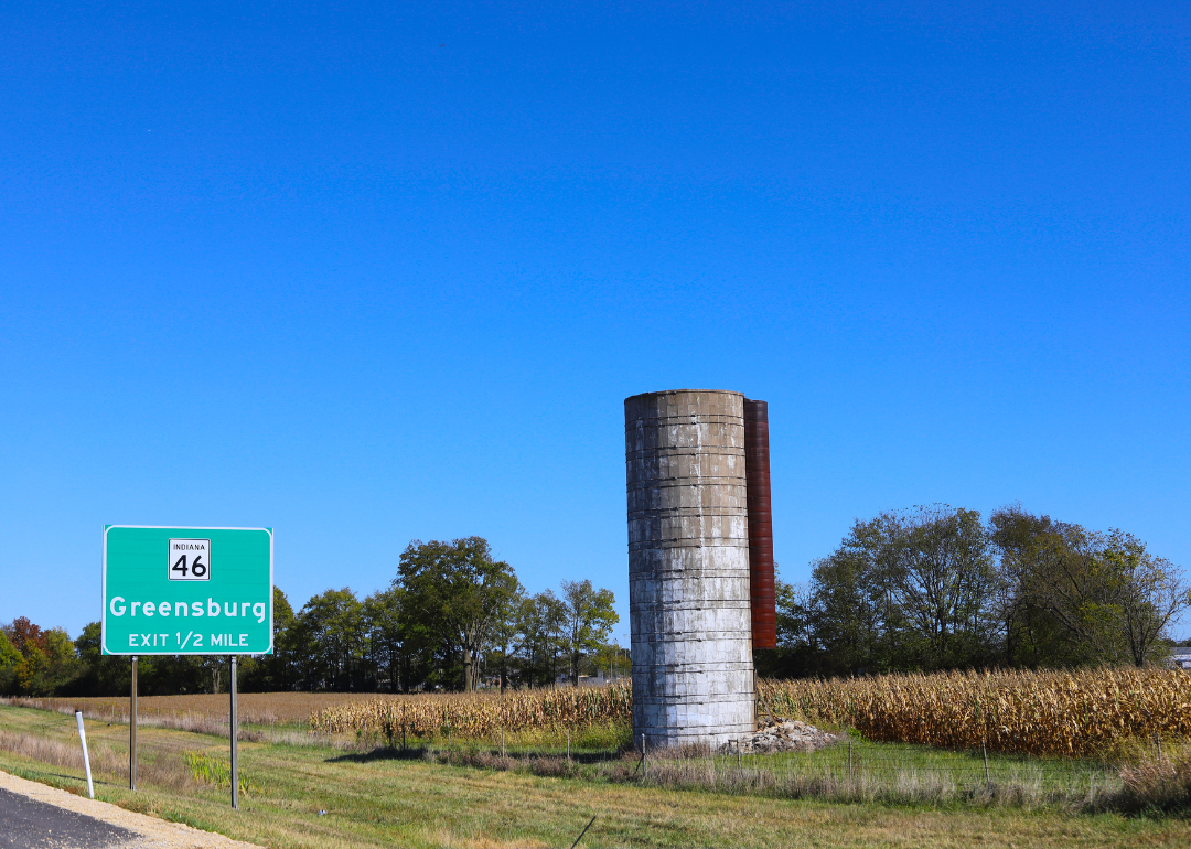
#28. Decatur County (tie)
– Life expectancy: 74.5 years
— 1.1 years lower than the state average
About
Decatur County, Indiana is marked by its farmland, quiet towns, and a courthouse that stands as one of the state’s most unique landmarks. Greensburg, the county seat, is recognized for the tree that has grown from its courthouse roof for more than a century, a feature that defines its local identity. Beyond the city, rural communities and open fields preserve the county’s agricultural traditions.
Community life is expressed through fairs, festivals, and gatherings that highlight local pride. Outdoor activities are enjoyed in parks, along trails, and across the county’s farmland. Decatur County remains a place where history, rural character, and community ties continue to shape everyday living.
Where is Decatur County?
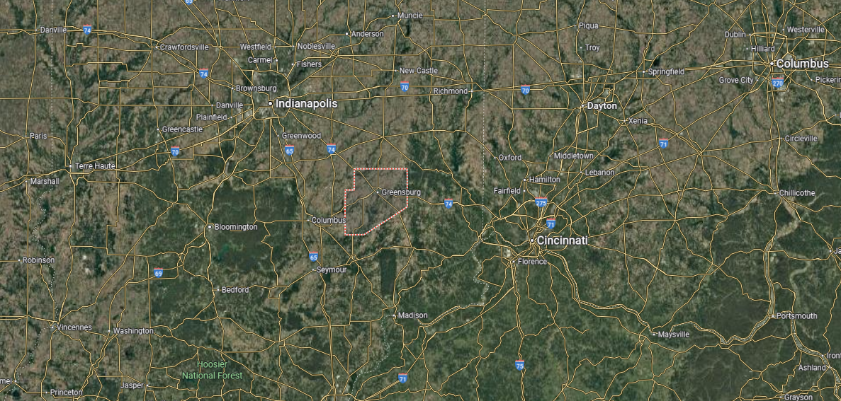
Decatur County is located in southeastern Indiana, bordered by Rush County to the north, Franklin County to the east, and Jennings and Ripley counties to the south. It covers about 375 square miles, with gently rolling farmland and small streams shaping its landscape. Agriculture has long been central to the county’s economy and identity.
Greensburg, the county seat, sits near the center and is famous for the “Tree Growing Out of the Courthouse Tower,” a unique local landmark. Other towns include Westport in the south and St. Paul on the northern edge. With its mix of rural communities, farmland, and historic charm, Decatur County highlights Indiana’s agricultural heartland.
#27. Fulton County (tie)
– Life expectancy: 74.4 years
— 1.2 years lower than the state average
You may also like: Airports using biometric facial recognition in Indiana

About
Fulton County, Indiana is shaped by open farmland, small towns, and a strong connection to its natural setting. Rochester, the county seat, reflects this balance with its historic courthouse and Lake Manitou, which serves as both a recreational hub and a local landmark. Across the county, agriculture and community traditions continue to guide daily life.
Fairs, festivals, and neighborhood events bring residents together and highlight a sense of shared pride. Outdoor recreation thrives on the lake, in parks, and along the county’s scenic backroads. Fulton County stands as a place where heritage, landscape, and community ties remain firmly connected.
Where is Fulton County?
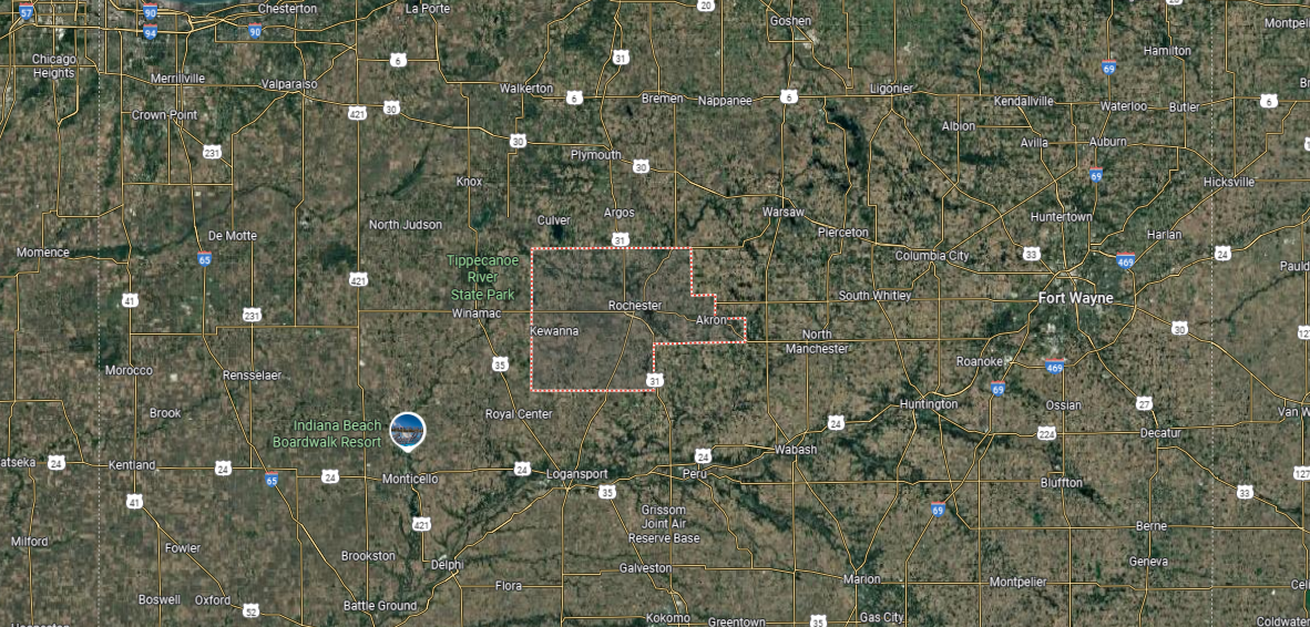
Fulton County is in north-central Indiana, bordered by Marshall County to the north, Kosciusko County to the northeast, and Cass and Miami counties to the south. It spans about 370 square miles, with terrain made up of fertile farmland, woodlands, and lakes. The Tippecanoe River runs through the county, adding to its natural setting.
Rochester, the county seat, lies near Lake Manitou and serves as the center of government and commerce. Smaller towns include Akron to the east and Kewanna to the west, both tied to the county’s rural heritage. With its blend of agriculture, small towns, and natural features, Fulton County reflects the balance of tradition and landscape in Indiana.
#26. Newton County (tie)
– Life expectancy: 74.4 years
— 1.2 years lower than the state average

About
Newton County, Indiana rests in the state’s northwest corner, where wide stretches of prairie, farmland, and small towns define its landscape. Kentland, the county seat, serves as the civic and cultural center, with a historic courthouse square that anchors community life. Agriculture has long been the foundation of the county’s economy, giving it a steady rhythm tied to the land.
Local identity is celebrated through county fairs, school events, and seasonal gatherings that connect neighbors across generations. Nature preserves and open countryside provide opportunities for outdoor recreation and reflection. Newton County endures as a place where rural tradition, natural beauty, and community spirit remain central to daily life.
Where is Newton County?
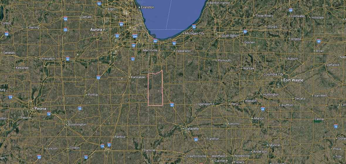
Newton County is located in northwestern Indiana, along the state’s border with Illinois. It is bordered by Jasper County to the east, Benton County to the south, and Lake County to the north. Covering about 400 square miles, the county features flat farmland, prairies, and wetlands, much of it once part of the Grand Kankakee Marsh.
Kentland, the county seat, sits near the center and serves as the hub of local government and commerce. Other towns include Morocco, Goodland, and Brook, each reflecting the county’s rural roots. With its agricultural base, open landscapes, and conservation areas, Newton County highlights Indiana’s prairie heritage.
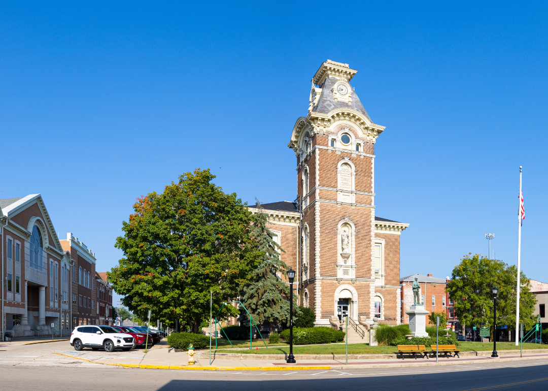
#25. Vigo County (tie)
– Life expectancy: 74.3 years
— 1.3 years lower than the state average
About
Vigo County, Indiana lies along the Wabash River, where history, education, and industry intersect in the heart of the state’s west. Terre Haute, the county seat, anchors the region with its universities, cultural institutions, and a legacy tied to commerce and railroads. Smaller towns and rural areas balance this urban presence, preserving traditions of farming and local pride.
Community life thrives through festivals, parades, and school events that bring residents together year after year. Parks, trails, and the riverfront provide recreation and keep people connected to the landscape. Vigo County stands as a place where history, education, and community spirit remain closely intertwined.
Where is Vigo County?
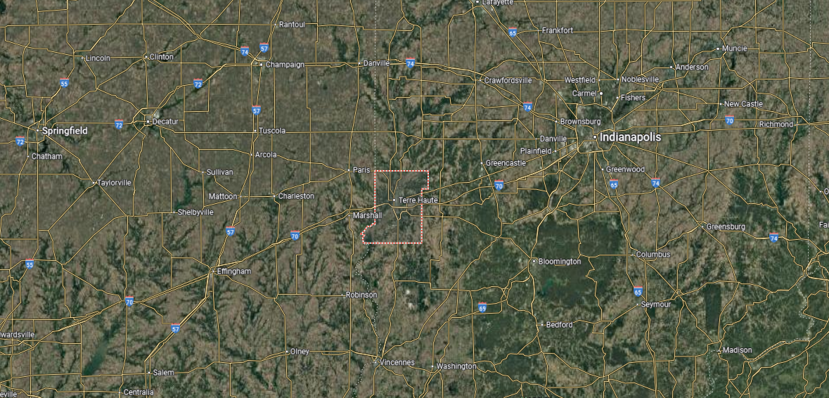
Vigo County is located in western Indiana, along the state’s border with Illinois. It is bordered by Vermillion County to the north, Clay County to the east, and Sullivan County to the south, with the Wabash River forming much of its western edge. Covering about 410 square miles, the county features fertile river plains, farmland, and expanding urban areas.
Terre Haute, the county seat and largest city, anchors Vigo County as a center of education, culture, and commerce. Other communities include West Terre Haute across the river and Seelyville to the east. With its universities, industrial base, and riverfront location, Vigo County blends tradition with regional growth.
#24. Wabash County (tie)
– Life expectancy: 74.3 years
— 1.3 years lower than the state average
About
Wabash County, Indiana carries a heritage shaped by its rivers, farmland, and historic towns. The city of Wabash, the county seat, is recognized as the first electrically lighted city in the world, a legacy that continues to symbolize local pride. Beyond the city, small communities and open countryside reflect the county’s enduring agricultural traditions.
Festivals, concerts, and school events bring residents together and highlight both history and culture. Outdoor recreation along the Wabash River, in parks, and on scenic trails connects people to the natural landscape. Wabash County remains a place where innovation, tradition, and community life come together in lasting form.
Where is Wabash County?
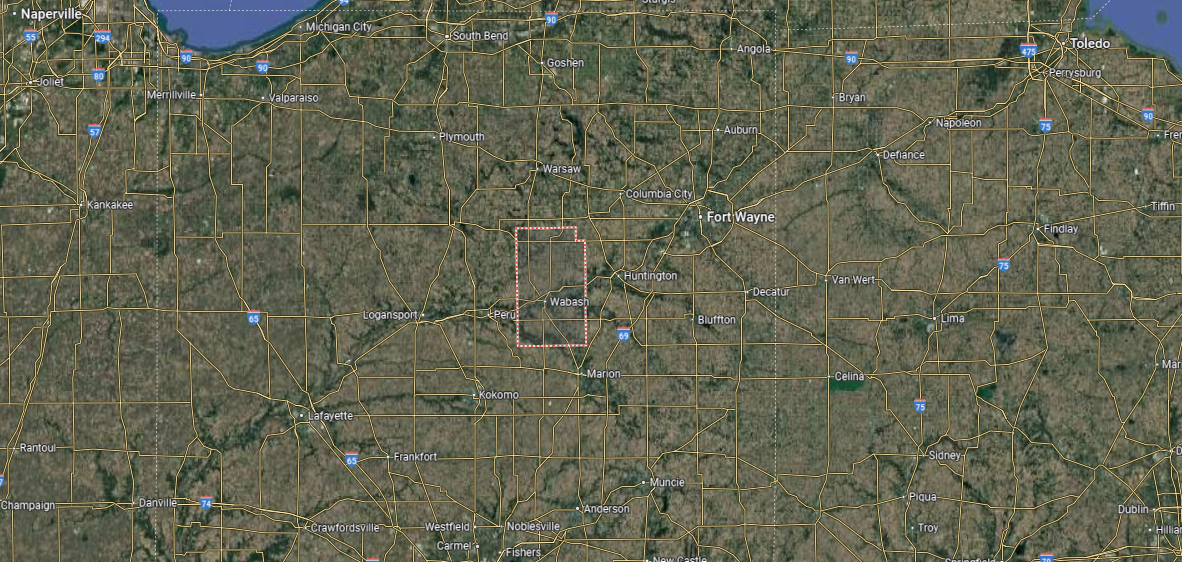
Wabash County is in north-central Indiana, bordered by Huntington County to the east, Miami County to the west, and Kosciusko and Whitley counties to the north. It covers about 420 square miles, with a landscape of fertile farmland, woodlands, and the Wabash River running through its center. The county’s history is closely tied to the river and early canal routes.
Wabash, the county seat, is noted as the first electrically lighted city in the world. Other communities include North Manchester in the north and La Fontaine to the south, both with strong local traditions. With its mix of historic towns, agriculture, and river valleys, Wabash County reflects the character of Indiana’s heartland.
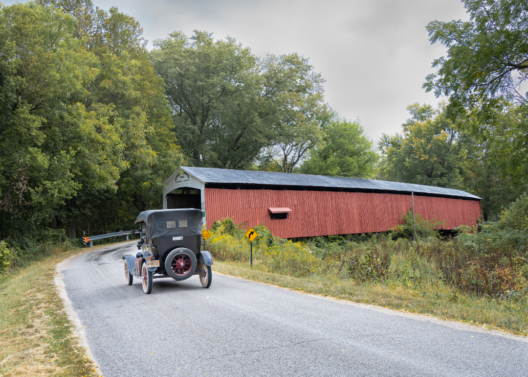
#23. Henry County (tie)
– Life expectancy: 74.2 years
— 1.4 years lower than the state average
About
Henry County, Indiana is set in the state’s east-central region, where farmland, small towns, and a legacy of civic life shape its character. New Castle, the county seat, is known for its ties to high school basketball history and for its historic courthouse that stands at the heart of the community. Agriculture and small industry continue to provide the backbone of the local economy.
Residents gather through school events, county fairs, and community festivals that highlight pride across generations. Parks, trails, and nearby reservoirs provide space for recreation and connection to the outdoors. Henry County endures as a place where tradition, community spirit, and rural heritage remain central to everyday life.
Where is Henry County?
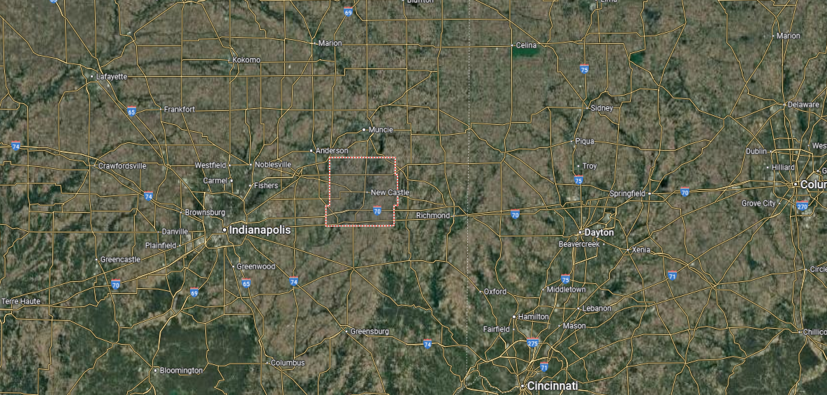
Henry County is located in east-central Indiana, bordered by Delaware County to the north, Wayne County to the east, and Hancock and Rush counties to the west and south. It spans about 395 square miles, with fertile farmland, small streams, and gently rolling terrain defining much of its landscape.
New Castle, the county seat, lies near the center and is known for its basketball heritage and automotive history. Other communities include Knightstown on the western edge and Middletown in the north. With its agricultural base, historic towns, and ties to Indiana’s sporting legacy, Henry County blends rural life with cultural significance.
#22. Vermillion County (tie)
– Life expectancy: 74.2 years
— 1.4 years lower than the state average
You may also like: Bestselling cars in Indiana
About
Vermillion County, Indiana sits along the Wabash River in the state’s western region, where farmland, river towns, and small communities define its landscape. Newport, the county seat, reflects a rich civic tradition and is widely known for hosting the Newport Antique Auto Hill Climb, a signature local event. Agriculture and river trade have long shaped the county’s economy and identity.
Local life is strengthened through festivals, school activities, and neighborhood gatherings that connect residents across generations. Outdoor opportunities along the Wabash River, in parks, and across open countryside tie people closely to the land. Vermillion County remains a place where history, tradition, and community pride are firmly rooted in daily living.
Where is Vermillion County?
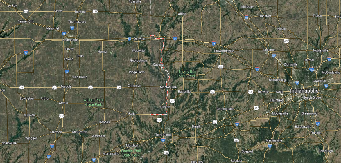
Vermillion County is located in western Indiana, along the state’s border with Illinois. It is bordered by Warren County to the north, Parke County to the east, and Vigo County to the south. Spanning about 260 square miles, it is one of Indiana’s smaller counties, with farmland, wooded areas, and the Wabash River shaping its landscape.
Newport, the county seat, sits near the center along the Wabash River. Other communities include Clinton in the south and Cayuga to the north, both reflecting the county’s industrial and agricultural roots. With its mix of small towns, historic riverfront, and rural countryside, Vermillion County highlights the quieter side of Indiana’s Wabash Valley.
#21. Crawford County (tie)
– Life expectancy: 74.2 years
— 1.4 years lower than the state average
About
Crawford County, Indiana is defined by its wooded hills, winding rivers, and small rural communities. English, the county seat, serves as the center of civic life, while surrounding towns and open countryside carry forward traditions tied to farming and local heritage. The presence of the Ohio River and nearby Hoosier National Forest highlights the county’s strong ties to nature.
Community pride is shown through local festivals, fairs, and school-centered events that bring residents together. Recreation is found in caves, on trails, and along riverbanks that showcase the region’s landscape. Crawford County remains a place where rural identity, natural beauty, and community spirit come together in everyday life.
Where is Crawford County?
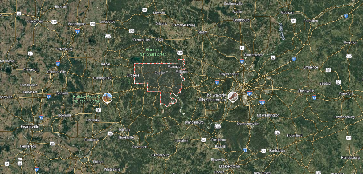
Crawford County is in southern Indiana, bordered by Orange County to the north, Harrison County to the east, and Perry County to the west, with the Ohio River forming much of its southern boundary. It spans about 310 square miles, featuring forested hills, limestone bluffs, and valleys tied to the river. Large portions of the Hoosier National Forest lie within its borders, adding to its natural character.
English, the county seat, is located inland near the center, while Marengo and Milltown are other notable communities. Recreational attractions include Wyandotte Caves, Patoka Lake, and riverfront access along the Ohio. With its rugged terrain, outdoor destinations, and small-town communities, Crawford County is defined by both its natural beauty and rural traditions.
#20. Jay County (tie)
– Life expectancy: 74.2 years
— 1.4 years lower than the state average
About
Jay County, Indiana is marked by its wide stretches of farmland, quiet towns, and traditions rooted in rural life. Portland, the county seat, serves as the civic and cultural center, with its courthouse square and community institutions anchoring local identity. Agriculture and small-scale industry remain central to the county’s character and economy.
Community spirit shows in county fairs, local festivals, and school gatherings that bring neighbors together. Parks, trails, and open countryside offer residents opportunities for recreation and reflection. Jay County stands as a place where farming heritage, civic pride, and a strong sense of community continue to guide daily living.
Where is Jay County?
Jay County is in east-central Indiana, along the state’s border with Ohio. It is bordered by Adams County to the north, Randolph County to the south, and Wells and Blackford counties to the west. Covering about 385 square miles, the county is marked by flat farmland, small rivers, and rural communities.
Portland, the county seat, sits near the center and serves as the hub of government and commerce. Other towns include Dunkirk on the southern edge and Redkey to the southwest. With its strong agricultural base and small-town character, Jay County reflects the rural heart of eastern Indiana.
#19. Randolph County
– Life expectancy: 74.1 years
— 1.5 years lower than the state average
About
Randolph County, Indiana rests along the state’s eastern border, where farmland, small towns, and historic communities define its setting. Winchester, the county seat, anchors the area with a classic courthouse square and traditions tied to local heritage. Agriculture has long been the backbone of the county, supported by small industries and community institutions.
Residents gather for county fairs, parades, and seasonal events that bring neighbors together. Outdoor recreation thrives in parks, along scenic backroads, and across the county’s open countryside. Randolph County remains a place where rural heritage, civic pride, and community ties shape everyday life.
Where is Randolph County?
Randolph County is located in east-central Indiana, along the border with Ohio. It is bordered by Jay County to the north, Wayne County to the south, and Delaware and Henry counties to the west. Spanning about 450 square miles, the county’s landscape is defined by flat farmland, small woodlands, and winding streams.
Winchester, the county seat, lies near the center and serves as the primary hub of government and community life. Other towns include Union City, which straddles the Indiana-Ohio line, and Farmland to the west. With its agricultural roots, cross-border connections, and small-town traditions, Randolph County reflects the rural character of eastern Indiana.
#18. Knox County
– Life expectancy: 73.9 years
— 1.7 years lower than the state average
About
Knox County, Indiana is the state’s oldest county, with roots reaching back to its days as part of the Northwest Territory. Vincennes, the county seat, reflects this history with preserved landmarks such as George Rogers Clark National Historical Park and Indiana’s first state capital site. The Wabash River and fertile farmland continue to shape both the landscape and the economy.
The county’s identity is tied to its historic role in early settlement, trade, and government, giving it a distinct place in Indiana’s story. Cultural institutions, museums, and historic districts highlight this legacy while supporting modern community life. Knox County stands as a region where deep history, fertile land, and civic tradition remain firmly connected.
Where is Knox County?
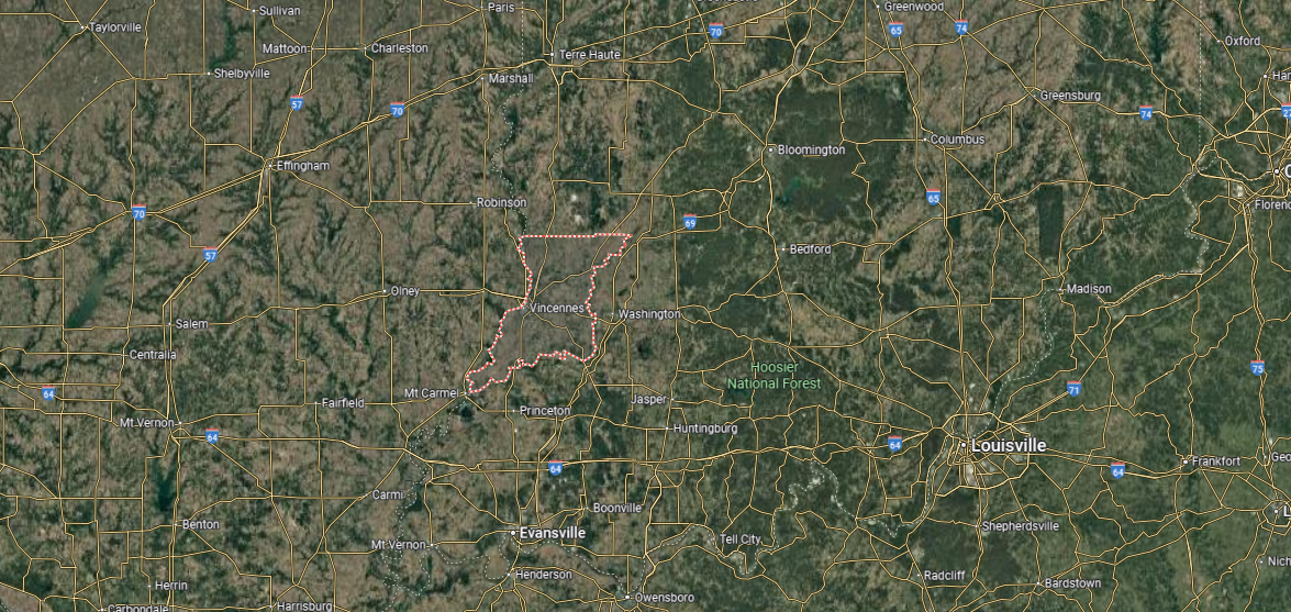
Knox County is located in southwestern Indiana, along the Wabash River and the Illinois state line. It is bordered by Sullivan County to the north, Daviess County to the east, and Gibson County to the south. Covering more than 520 square miles, it is one of Indiana’s oldest counties, with fertile farmland, river bottoms, and historic settlements.
Vincennes, the county seat, is the oldest city in Indiana and served as the state’s first capital. Other communities include Bicknell, Oaktown, and Monroe City, each tied to the county’s agricultural and historic base. With its rich heritage, fertile lands, and riverfront setting, Knox County blends Indiana’s frontier history with rural tradition.
#17. Marion County (tie)
– Life expectancy: 73.8 years
— 1.8 years lower than the state average
You may also like: These are the most prevalent disabilities in Indiana
About
Marion County, Indiana is the state’s capital region, home to Indianapolis, which serves as both the county seat and Indiana’s largest city. The county has grown around its role as a center of government, commerce, and culture, with a history tied to transportation and industry. Surrounding neighborhoods and suburban communities reflect a mix of historic districts, urban development, and civic traditions.
The county is defined by its cultural institutions, sports venues, and universities, which give it statewide and national significance. Parks, greenways, and the White River offer natural spaces that balance the pace of urban life. Marion County endures as a place where history, innovation, and civic identity converge in lasting form.
Where is Marion County?
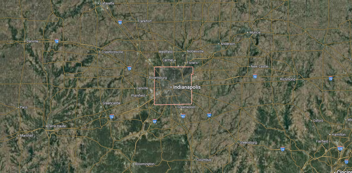
Marion County is located in central Indiana and serves as the state’s most populous county. It is bordered by Hamilton County to the north, Hancock County to the east, Johnson County to the south, and Hendricks County to the west. Spanning about 403 square miles, the county is heavily urbanized, with the White River and its tributaries running through its landscape.
Indianapolis, the county seat and state capital, dominates Marion County as its cultural, political, and economic center. Surrounding townships and neighborhoods, such as Lawrence, Speedway, and Warren, add to the county’s diverse communities. With its blend of government, business, sports, and cultural institutions, Marion County stands as the heart of Indiana.
#16. Clark County (tie)
– Life expectancy: 73.8 years
— 1.8 years lower than the state average

About
Clark County, Indiana lies along the Ohio River in the state’s southern region, where its history is tied to early settlement and river trade. Jeffersonville, the county seat, has long been connected to Louisville across the river and continues to serve as a hub of commerce and civic life. Historic ties to industry and shipbuilding remain part of the county’s character, balanced by growing suburban communities.
The Ohio River shapes much of the landscape, providing both transportation routes and scenic views. Parks, trails, and nearby natural areas add opportunities for recreation while preserving connections to the land. Clark County stands as a place where history, river heritage, and modern growth intersect.
Where is Clark County?
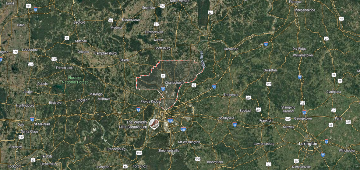
Clark County is in southern Indiana, along the Ohio River directly across from Louisville, Kentucky. It is bordered by Floyd County to the west, Scott County to the north, and Jefferson County to the east. Covering about 375 square miles, the county combines suburban development, farmland, and riverfront landscapes.
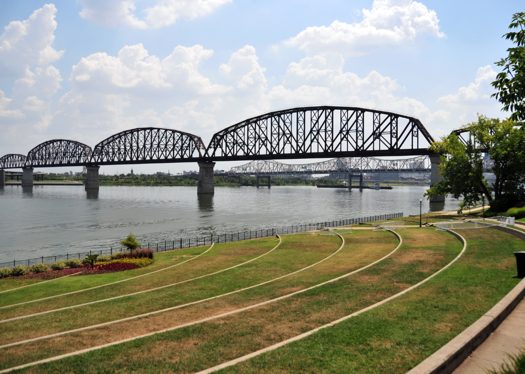
Jeffersonville, the county seat, lies on the river and serves as a gateway to Louisville via the Big Four and Abraham Lincoln bridges. Other communities include Charlestown, Sellersburg, and Clarksville, each adding to the county’s suburban and industrial growth. With its strong river connections, expanding neighborhoods, and historical ties, Clark County blends metropolitan influence with Indiana’s southern character.
#15. Orange County (tie)
– Life expectancy: 73.8 years
— 1.8 years lower than the state average

About
Orange County, Indiana is set in the southern hills, where small towns, caves, and mineral springs have shaped its unique identity. Paoli, the county seat, reflects local heritage through its historic square and role as a civic center. Tourism has long been part of the county’s character, with attractions such as French Lick and West Baden Springs preserving a legacy of resorts and architecture.
The county’s landscape blends rolling farmland with forests, offering a backdrop for both agriculture and recreation. Trails, state parks, and natural landmarks like Patoka Lake highlight the area’s connection to the outdoors. Orange County remains a place where history, natural resources, and community tradition come together in distinctive form.
Where is Orange County?
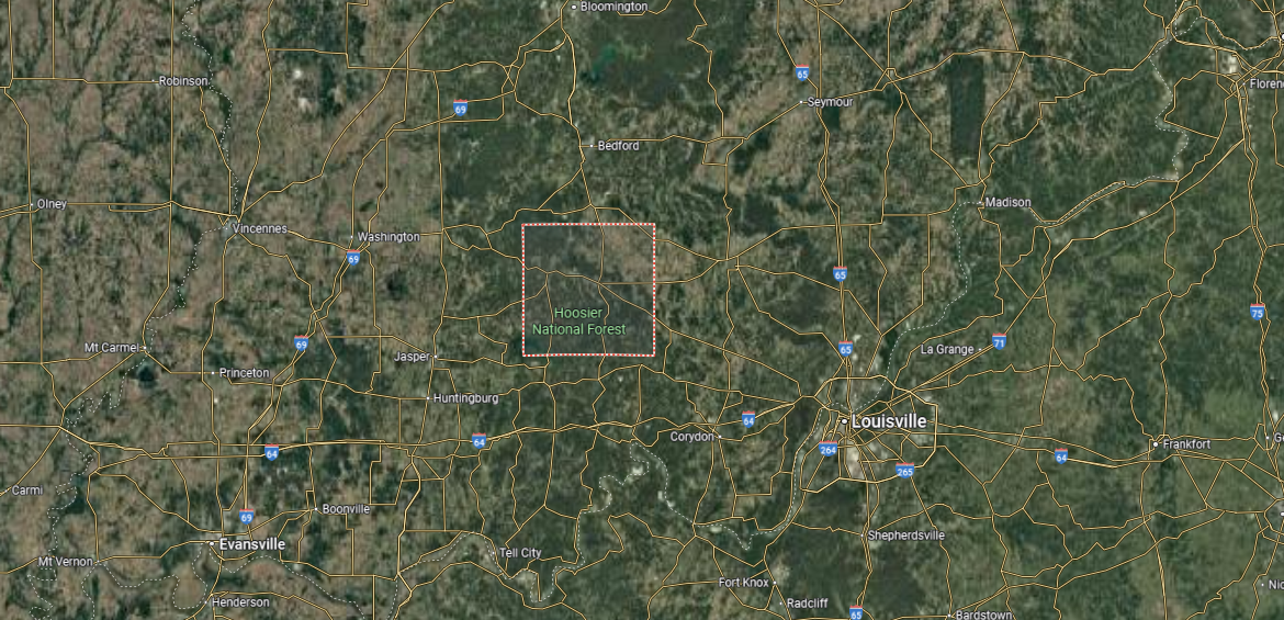
Orange County is located in southern Indiana, bordered by Lawrence County to the north, Washington County to the east, and Crawford and Dubois counties to the south and west. It spans about 400 square miles, with terrain defined by rolling hills, caves, and portions of the Hoosier National Forest. The county is also known for its mineral springs and historic resorts.
Paoli, the county seat, sits near the center and serves as the hub of government and community life. Other towns include French Lick and West Baden Springs, both famous for their historic hotels and tourism industry. With its natural landscapes, caves, and resort heritage, Orange County highlights the blend of recreation and history in southern Indiana.
#14. Madison County (tie)
– Life expectancy: 73.8 years
— 1.8 years lower than the state average

About
Madison County, Indiana rests in the state’s central region, where farmland, small towns, and manufacturing centers shape its identity. Anderson, the county seat, grew during the era of natural gas discovery and remains a hub for industry, education, and culture. Other communities across the county reflect a blend of rural tradition and suburban growth tied to nearby metropolitan areas.
The county’s character is defined by its historic downtowns, cultural institutions, and strong ties to both agriculture and industry. Parks, trails, and the White River provide natural spaces that balance community and landscape. Madison County stands as a place where heritage, progress, and local identity remain closely linked.
Where is Madison County?
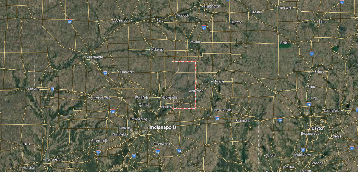
Madison County is in central Indiana, bordered by Grant County to the north, Hancock County to the south, and Hamilton and Delaware counties to the west and east. It covers about 450 square miles, with a landscape of fertile farmland, small rivers, and growing suburban areas tied to the Indianapolis metro region.
Anderson, the county seat and largest city, sits along the White River and has a history rooted in manufacturing and automotive industries. Other communities include Alexandria to the north and Pendleton in the southwest, both with strong local traditions. With its mix of agriculture, industry, and suburban growth, Madison County reflects both historic and modern influences in central Indiana.
#13. Washington County (tie)
– Life expectancy: 73.8 years
— 1.8 years lower than the state average
About
Washington County, Indiana is located in the state’s southern uplands, where farmland, forests, and small towns define its rural character. Salem, the county seat, preserves a historic courthouse square and serves as the cultural and civic center of the region. Agriculture and small-scale industry provide the economic backbone, continuing traditions that have guided the county for generations.
The landscape is marked by rolling hills, creeks, and wooded areas that support both farming and outdoor activity. Festivals, fairs, and heritage events highlight the county’s history while adding to its sense of community. Washington County endures as a place where natural setting, tradition, and local pride remain firmly rooted.
Where is Washington County?
Washington County is located in southern Indiana, bordered by Jackson County to the east, Lawrence County to the north, and Harrison and Orange counties to the south and west. It spans about 515 square miles, with rolling farmland, wooded hills, and parts of the Hoosier National Forest shaping its landscape. The county’s terrain reflects both agricultural and natural diversity.
Salem, the county seat, lies near the center and serves as the hub of government and commerce. Other small towns include Pekin, Campbellsburg, and Little York, each rooted in rural traditions. With its mix of farmland, forests, and historic communities, Washington County highlights the character of southern Indiana’s countryside.
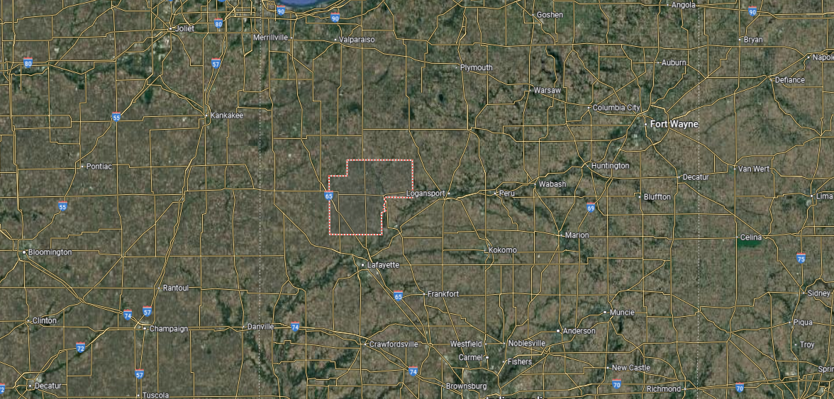
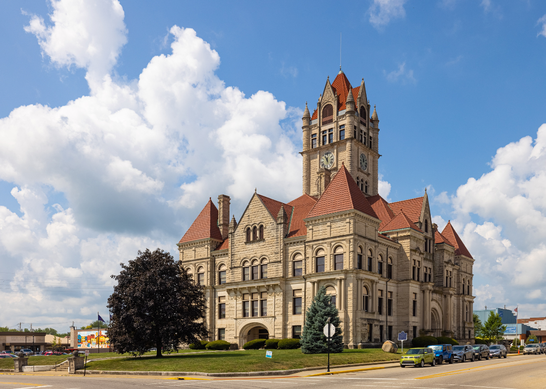
#12. Fountain County (tie)
– Life expectancy: 73.7 years
— 1.9 years lower than the state average
You may also like: Counties receiving the most SBA loans in Indiana
About
Fountain County, Indiana is shaped by its position along the Wabash River, where agriculture and small-town life remain central. Covington, the county seat, anchors community life with its courthouse square and historic presence. Beyond the town, farmland, woodlands, and quiet villages reflect the county’s enduring rural traditions.
The landscape offers both beauty and purpose, with open fields, parks, and covered bridges adding to its character. Local fairs and cultural gatherings highlight the county’s history and sense of identity. Fountain County endures as a place where rural heritage, natural features, and community values continue to guide daily life.
Where is Fountain County?
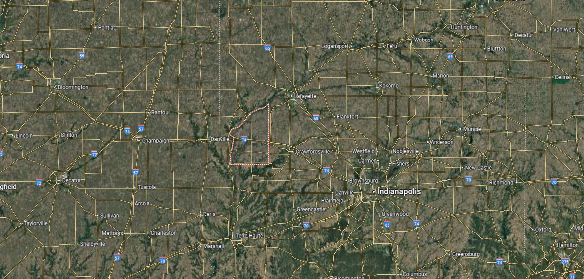
Fountain County is in western Indiana, along the state’s border with Illinois. It is bordered by Warren County to the north, Montgomery County to the east, and Parke and Vermillion counties to the south. Spanning about 400 square miles, the county is defined by farmland, wooded areas, and the Wabash River, which forms much of its northern boundary.
Covington, the county seat, sits along the Wabash River and serves as the center of government and community life. Other towns include Attica to the northeast and Veedersburg near the county’s center, both with strong local identities. With its agricultural base, small towns, and river landscapes, Fountain County reflects the rural character of western Indiana.
#11. Jennings County (tie)
– Life expectancy: 73.7 years
— 1.9 years lower than the state average
About
Jennings County, Indiana holds a distinctive place in the state’s story as home to Vernon, the first town in Indiana placed on the National Register of Historic Places. Its courthouse, built in 1859, stands as one of the oldest still in use, giving the county deep architectural and civic significance. North Vernon, the county’s largest city, developed as a rail town and continues to reflect that history in its layout and industry.
The county has long been shaped by its position as a crossroads of rail, trade, and agriculture, which influenced settlement patterns and economic life. Cultural institutions, historic districts, and preserved sites highlight this blend of heritage and progress. Jennings County stands out as a place where early state history, civic tradition, and rail-era development remain defining features.
Where is Jennings County?
Jennings County is located in southeastern Indiana, bordered by Decatur County to the north, Ripley County to the east, and Jackson and Bartholomew counties to the west. It covers about 380 square miles, with a landscape of fertile farmland, wooded hills, and creeks flowing into the Muscatatuck River. Large portions of the county are also covered by state and federal forestlands.
Vernon, the county seat, is a small historic town near the center, while North Vernon, the largest community, lies just to its north. Other towns include Butlerville and Hayden, each reflecting the county’s rural roots. With its combination of agriculture, forests, and historic towns, Jennings County blends natural beauty with small-town character.
#10. Owen County
– Life expectancy: 73.5 years
— 2.1 years lower than the state average
About
Owen County, Indiana carries a strong historical and cultural legacy as one of the state’s earliest settled regions. Spencer, the county seat, is anchored by its 1911 Romanesque Revival courthouse, a symbol of civic life that continues to serve as a centerpiece of the community. The county is also known for its connection to McCormick’s Creek State Park, Indiana’s very first state park, established in 1916.
Industry and commerce here have long been tied to limestone, small manufacturing, and agriculture, blending natural resources with local enterprise. Historic districts, preserved buildings, and cultural events highlight the county’s enduring heritage. Owen County stands out as a place where state history, civic institutions, and natural milestones intersect in meaningful ways.
Where is Owen County?
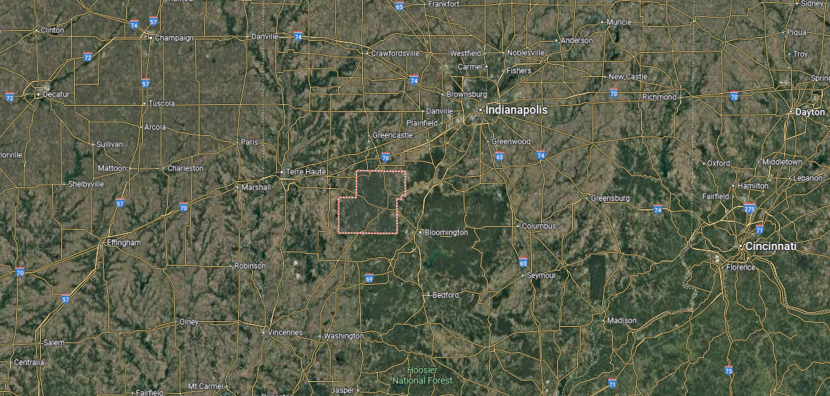
Owen County is in west-central Indiana, bordered by Putnam County to the north, Morgan County to the east, and Greene and Monroe counties to the south. It spans about 385 square miles, with a landscape of rolling hills, farmland, and wooded areas shaped by the White River and its tributaries. Much of the county retains a distinctly rural character.
Spencer, the county seat, lies along the White River and serves as the hub of government and commerce. Other communities include Gosport in the northeast and Freedom to the south, both reflecting small-town traditions. With its mix of farmland, forests, and rivers, Owen County highlights the natural and rural setting of west-central Indiana.
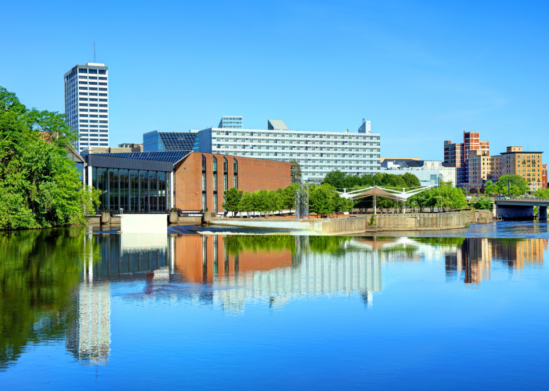
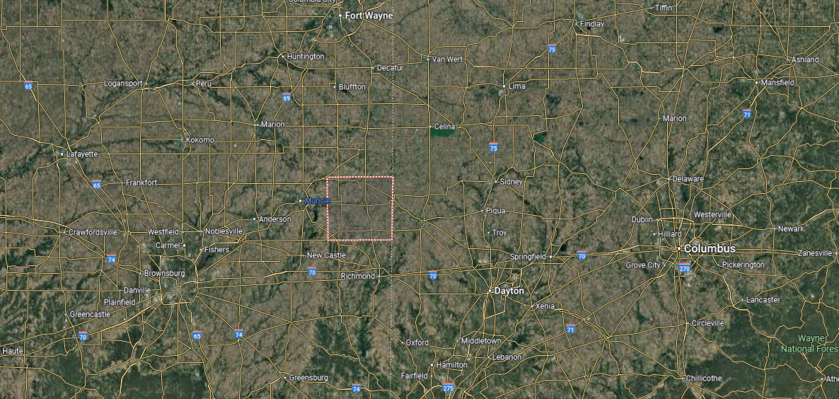
#9. Delaware County
– Life expectancy: 73.1 years
— 2.5 years lower than the state average

About
Delaware County, Indiana developed as an industrial and educational hub in the state’s east-central region. Muncie, the county seat, is best known as the home of Ball State University and the Ball Corporation legacy, both of which left lasting marks on its culture and economy. The county also gained national recognition through the “Middletown” sociological studies, which portrayed Muncie as a reflection of small-city American life in the 20th century.
While higher education and industry anchor its identity, the county also holds a strong arts presence, with theaters, galleries, and historic venues contributing to local life. Economic roots in glassmaking and manufacturing remain part of its story even as new development takes shape. Delaware County endures as a place where scholarship, culture, and industrial history converge.
Where is Delaware County?
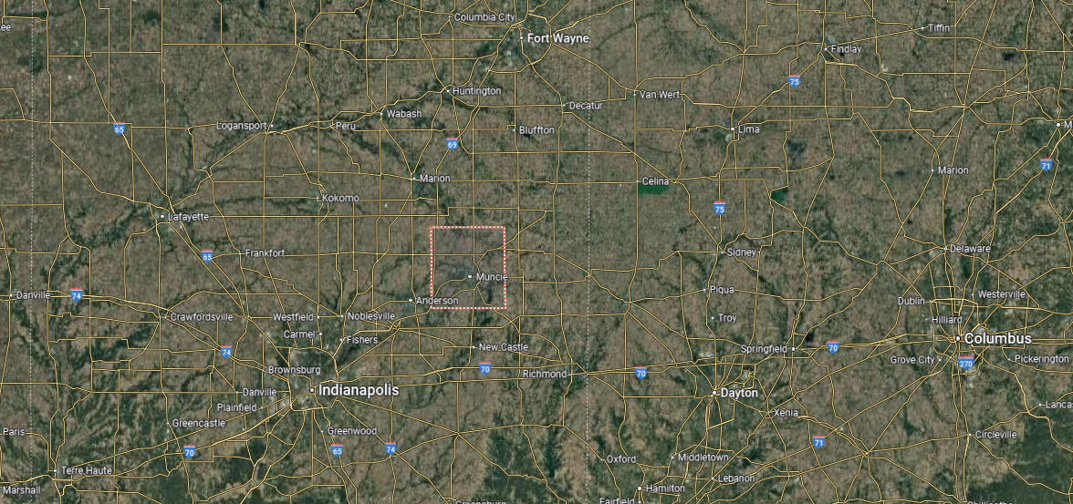
Delaware County is located in east-central Indiana, bordered by Blackford County to the north, Randolph County to the east, and Henry and Madison counties to the south. It covers about 395 square miles, with fertile farmland, the White River, and expanding suburban areas shaping its landscape. The county has long been a center for both agriculture and manufacturing.
Muncie, the county seat and largest city, anchors the region as home to Ball State University and a strong cultural presence. Other towns include Yorktown to the west and Albany to the northeast, each with deep local roots. With its mix of education, industry, and rural communities, Delaware County balances tradition with modern growth.
#8. Blackford County (tie)
– Life expectancy: 73.0 years
— 2.6 years lower than the state average

About
Blackford County, Indiana is one of the state’s smallest counties, yet its history reflects the sweeping changes of Indiana’s industrial past. Hartford City, the county seat, rose during the late 19th-century natural gas boom, when glassmaking and manufacturing transformed the area into a hub of industry. Montpelier also thrived in that era, known for its oil fields and rapid growth tied to energy resources.
Although the boom years passed, the legacy of industry remains visible in the county’s historic buildings, factories, and cultural memory. Agriculture and small manufacturing later filled the gap, maintaining stability and community life. Blackford County stands as a reminder of Indiana’s gas boom era, where rapid growth, industrial energy, and lasting resilience shaped its identity.
Where is Blackford County?
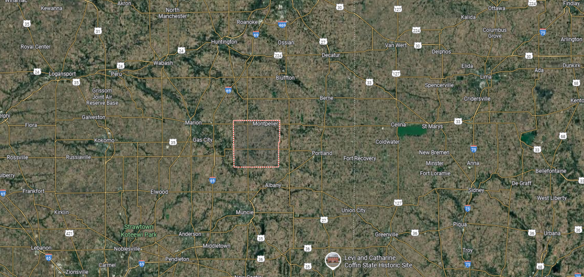
Blackford County is in east-central Indiana, bordered by Wells County to the northeast, Grant County to the west, and Jay County to the south. It is one of Indiana’s smaller counties, spanning just over 165 square miles, with flat farmland and small streams shaping its landscape. The county has strong agricultural roots, with corn and soybean production at its core.
Hartford City, the county seat, sits near the center and serves as the hub of government and community life. Montpelier, the other incorporated city, lies in the northwest and carries a history tied to the Indiana Gas Boom. With its rural character, small towns, and historic ties, Blackford County reflects the quieter side of Indiana’s heartland.
#7. Howard County (tie)
– Life expectancy: 73.0 years
— 2.6 years lower than the state average
You may also like: Counties with the lowest cost of living in Indiana
About
Howard County, Indiana holds a central place in the state’s industrial story, shaped by the natural gas boom of the late 1800s and its role in automotive manufacturing. Kokomo, the county seat, became known as the “City of Firsts” for its many innovations, including the first commercially produced automobile, the first push-button car radio, and contributions to aerospace technology. These milestones gave the county a national reputation for invention and progress.
The presence of major industries like Chrysler and Delco further defined Howard County’s economy, making it a hub of skilled labor and innovation throughout the 20th century. Today, cultural institutions, museums, and historic districts preserve this legacy while supporting a diverse community. Howard County endures as a place where industrial achievement, creativity, and local history remain central to its identity.
Where is Howard County?
Howard County is located in north-central Indiana, bordered by Miami County to the north, Tipton County to the south, and Carroll and Cass counties to the west. It spans about 290 square miles, with flat farmland and the Wildcat Creek flowing through its landscape. The county has long been linked to both agriculture and automotive manufacturing.
Kokomo, the county seat and largest city, anchors the area as a hub of industry and innovation. Smaller communities include Greentown to the east and Russiaville to the southwest, both with strong local traditions. With its mix of rural towns, industrial base, and community life, Howard County reflects both heritage and modern growth in Indiana.
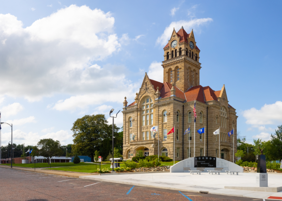
#6. Wayne County
– Life expectancy: 72.6 years
— 3.0 years lower than the state average
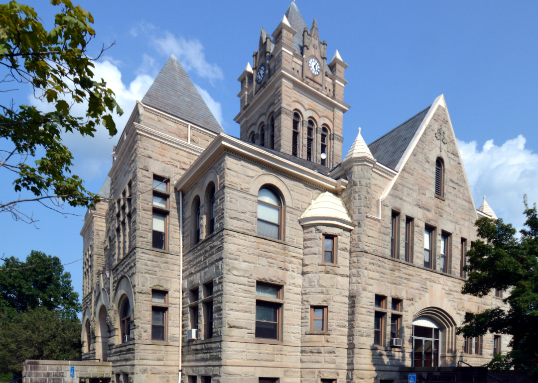
About
Wayne County, Indiana is deeply tied to the state’s early history and cultural development. Richmond, the county seat, became a center for manufacturing and commerce in the 19th century, while also gaining national recognition as a hub for early jazz recording through the Gennett Records label. The city’s historic architecture and cultural institutions reflect a legacy that blends industry with the arts.
The county also played a role in the state’s social and political history, with strong Quaker influences shaping movements such as abolition and education. Historic landmarks, museums, and preserved districts highlight these contributions while keeping the county’s past connected to its present. Wayne County stands as a place where innovation, culture, and civic ideals have left a lasting mark on Indiana’s identity.
Where is Wayne County?
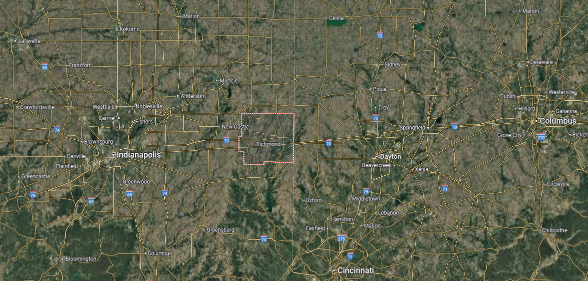
Wayne County is in eastern Indiana, along the state’s border with Ohio. It is bordered by Randolph County to the north, Fayette and Union counties to the south, and Henry County to the west. Spanning about 404 square miles, the county features fertile farmland, small rivers, and a strong network of historic towns.
Richmond, the county seat, lies near the center and anchors the region with its cultural, educational, and industrial roles. Other communities include Cambridge City, known for its historic district, and Hagerstown in the northern part of the county. With its mix of agriculture, historic heritage, and cross-state connections, Wayne County reflects both tradition and regional importance.
#5. Pulaski County
– Life expectancy: 72.5 years
— 3.1 years lower than the state average
About
Pulaski County, Indiana is a rural county in the northwestern part of the state, known for its quiet towns and strong agricultural base. Winamac, the county seat, serves as the civic center and is home to historic landmarks that reflect the county’s heritage. The Tippecanoe River flows through the area, adding both natural beauty and historical importance as a travel and trade route.
The county is also home to the Tippecanoe River State Park, one of its most recognized sites, which preserves woodlands and provides recreational opportunities. Agriculture has remained the backbone of Pulaski County’s economy, with generations of farming shaping its identity. Pulaski County stands as a place where history, farming traditions, and natural resources remain central to its character.
Where is Pulaski County?
Pulaski County is located in northwestern Indiana, bordered by Starke County to the north, White County to the south, and Fulton and Jasper counties on its eastern and western edges. It spans about 435 square miles, with flat farmland, woodlands, and the Tippecanoe River running through its center. Agriculture has long been the backbone of the county’s economy.
Winamac, the county seat, sits near the river and serves as the hub of government and commerce. Other communities include Francesville in the south and Medaryville in the north, both rooted in farming traditions. With its rural towns, river landscapes, and agricultural strength, Pulaski County reflects the character of Indiana’s countryside.
#4. Starke County
– Life expectancy: 72.4 years
— 3.2 years lower than the state average
About
Starke County, Indiana lies in the northwestern part of the state, where small towns and agricultural traditions form its foundation. Knox, the county seat, is the hub of government and community life, with a courthouse that has long anchored the downtown square. Railroads and farming played central roles in the county’s development, shaping its economy and settlement patterns.
The county is also noted for Bass Lake, once a popular resort destination and still a point of recreation and local pride. Historic sites and preserved landmarks highlight the area’s ties to both industry and leisure. Starke County endures as a place where rural heritage, civic tradition, and cultural history intersect.
Where is Starke County?
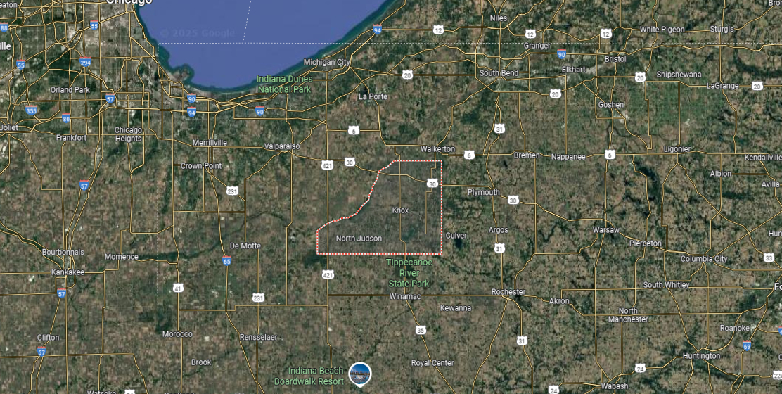
Starke County is in northwestern Indiana, bordered by LaPorte County to the north, Marshall County to the east, and Pulaski County to the south. It covers about 310 square miles, with flat farmland, woodlands, and several lakes, including Bass Lake, one of the largest natural lakes in the state. The county’s landscape reflects a mix of agriculture and recreation.
Knox, the county seat, sits near the center and serves as the hub of government and local life. Other communities include North Judson to the west and Hamlet to the north, each tied to farming and small-town traditions. With its agricultural roots, lakes, and rural charm, Starke County highlights the quieter side of northwestern Indiana.
#3. Grant County
– Life expectancy: 71.9 years
— 3.7 years lower than the state average
About
Grant County, Indiana carries a legacy shaped by both industry and culture in the state’s east-central region. Marion, the county seat, grew with the natural gas boom of the late 19th century and became a center for glassmaking and manufacturing. That industrial foundation left a lasting mark, even as the county adapted to new economic shifts over time.
The county is also known for its contributions to music and the arts, with ties to James Dean and Garfield creator Jim Davis adding to its cultural identity. Historic districts, theaters, and museums preserve these legacies while fostering community pride. Grant County stands as a place where industry, creativity, and history remain closely linked.
Where is Grant County?
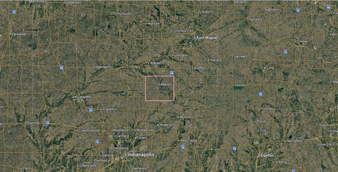
Grant County is located in east-central Indiana, bordered by Wabash County to the north, Blackford County to the east, and Madison and Tipton counties to the south. It spans about 415 square miles, with a landscape of fertile farmland, small rivers, and wooded areas. Agriculture and manufacturing have long shaped the county’s economy.
Marion, the county seat and largest city, lies near the center along the Mississinewa River. Other communities include Gas City, Jonesboro, and Fairmount, the latter known as the hometown of actor James Dean. With its blend of rural traditions, industrial heritage, and cultural ties, Grant County reflects both history and small-town character in Indiana.
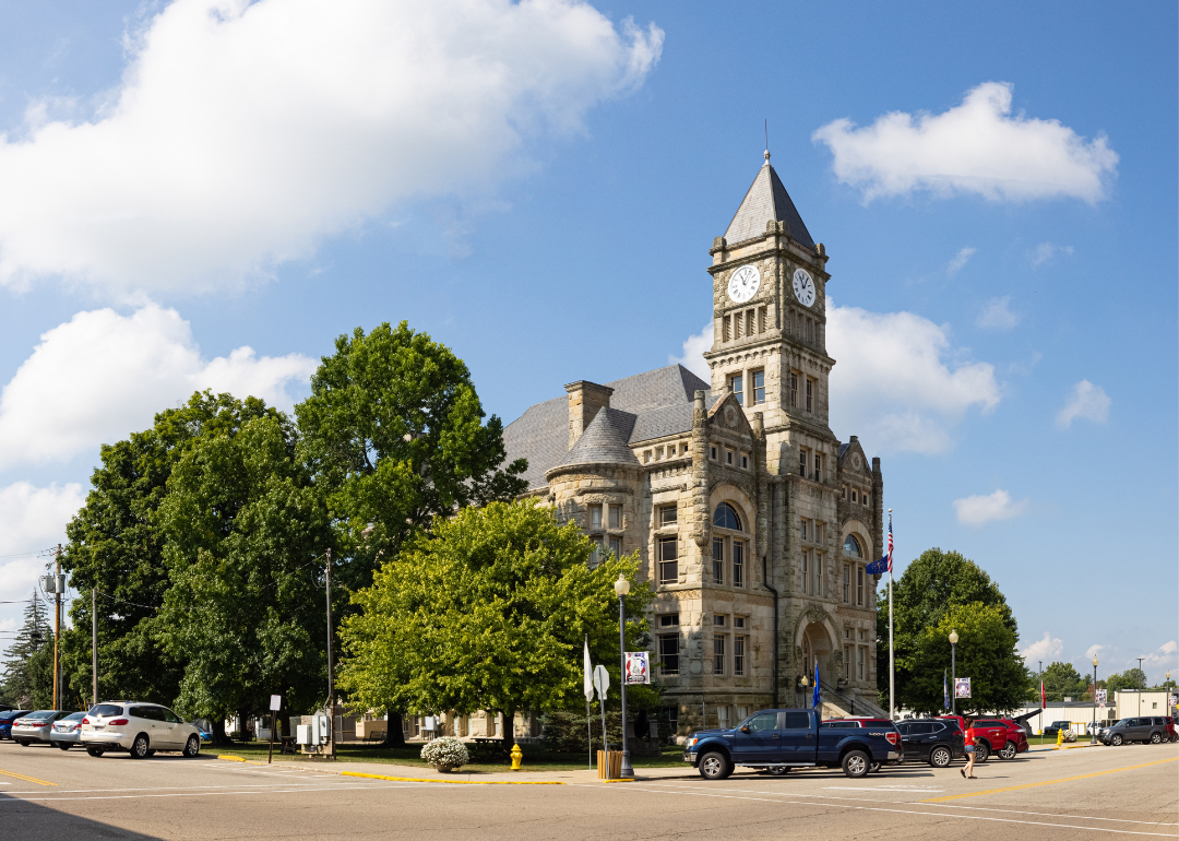
#2. Fayette County
– Life expectancy: 71.8 years
— 3.8 years lower than the state average
You may also like: Best counties to live in Indiana
About
Fayette County, Indiana is one of the state’s early industrial centers, shaped by manufacturing and its position along important transportation routes. Connersville, the county seat, earned the nickname “Little Detroit” in the early 20th century for its strong presence in the automobile industry, including carriages and later automobiles produced by several companies. This industrial legacy remains a defining chapter in the county’s history.
Beyond industry, the county holds significance as part of Indiana’s early settlement era, with historic buildings and institutions reflecting its long civic tradition. Museums, preserved sites, and cultural events continue to showcase this heritage. Fayette County stands as a place where early manufacturing strength, transportation history, and civic pride intersect.
Where is Fayette County?
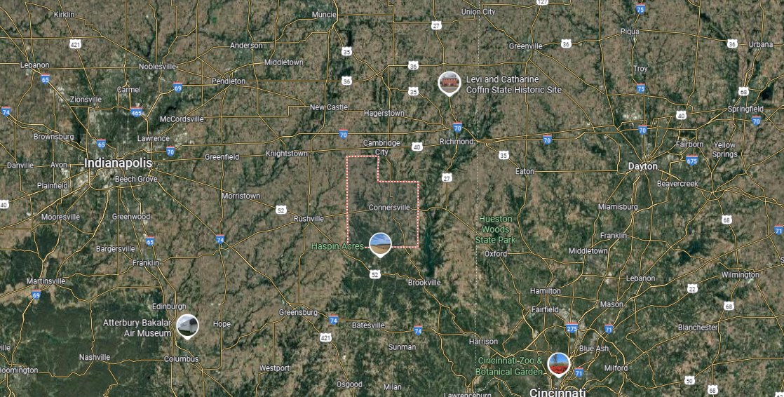
Fayette County is in east-central Indiana, bordered by Wayne County to the east, Rush County to the west, and Franklin and Union counties to the south. It is one of the state’s smaller counties, spanning about 215 square miles, with gently rolling farmland and the Whitewater River flowing through its landscape.
Connersville, the county seat and only incorporated city, lies near the center and has long served as the hub of government, industry, and commerce. Smaller communities include Glenwood on the western edge and Everton in the south. With its agricultural roots, historic industries, and river setting, Fayette County highlights the character of Indiana’s Whitewater Valley.
#1. Scott County
– Life expectancy: 69.5 years
— 6.1 years lower than the state average
About
Scott County, Indiana rests in the southern part of the state, where its history has been shaped by both transportation routes and small-town life. Scottsburg, the county seat, developed as a crossroads community with the arrival of the railroad in the mid-19th century, linking the county to wider markets and commerce. Agriculture and light industry have continued to support its economy, giving the area a steady foundation.
The county holds a heritage of resilience, with historic courthouses, local institutions, and preserved sites reflecting its civic traditions. Cultural gatherings and historical events highlight this past while connecting to the present. Scott County endures as a place where transportation history, rural roots, and community identity remain closely tied together.
Where is Scott County?
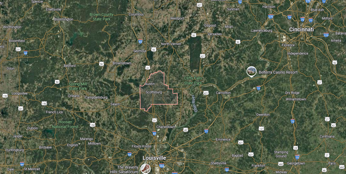
Scott County is located in southern Indiana, bordered by Jackson County to the north, Jefferson County to the east, and Washington County to the west. It covers about 190 square miles, making it one of the smaller counties in the state, with a landscape of farmland, wooded hills, and creek valleys. The Muscatatuck River forms part of its southeastern boundary.
Scottsburg, the county seat and largest city, lies near the center along Interstate 65, serving as the main hub of government and commerce. Other communities include Austin to the south and Lexington to the east, both rooted in small-town traditions. With its blend of rural landscapes, historic towns, and strong transportation links, Scott County connects southern Indiana’s countryside with modern accessibility.
This story features data reporting by Karim Noorani, writing by Kiersten Hickman, and is part of a series utilizing data automation across 49 states.
By Stacker