🔥 Would you like to save this?
Western Nevada is dotted with little pockets of life that sit quietly between volcanic ridges, dry playas, and wagon-rut valleys. These places have never tried to keep up with the fast lane; instead, they keep the porch light on for travelers who crave wide horizons and unhurried days.
Some began as mining camps, others formed around water in the desert, yet all now share a refreshing lack of traffic, chain stores, and glowing billboards. Visiting any of them feels like stepping through a door in time where the sky is larger, the nights are darker, and neighbors wave because they actually know one another.
In order to come up with the very specific design ideas, we create most designs with the assistance of state-of-the-art AI interior design software. Also, assume links that take you off the site are affiliate links such as links to Amazon. this means we may earn a commission if you buy something.
Our countdown highlights 25 of these out-of-the-way communities, noting what to explore, how locals earn a living, and why each remains blissfully off the main drag.
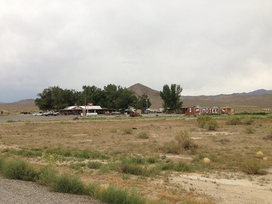
25. Denio – Border Outpost with Big-Sky Quiet
Denio sits where Nevada brushes Oregon, a scatter of houses, a café, and a tiny airstrip ringed by sagebrush and distant rims. It stays secluded because it’s hours from any city and caught between refuges, playas, and ranch country that keep development at bay.
The vibe is ranch-casual: dust on boots, pickup waves, and porch lights that feel ceremonial. Spend a morning soaking at nearby Alvord Desert hot springs, look for wild horses toward the Pueblo Mountains, cast for trout on the Quinn River, or chase golden-hour shots along empty fence lines.
Work here is cattle, guiding, and a few highway services that close early. When night falls, coyotes stitch the dark with yips, and the stars look almost close enough to cup. It’s the kind of place that reminds you how quiet the world can be.
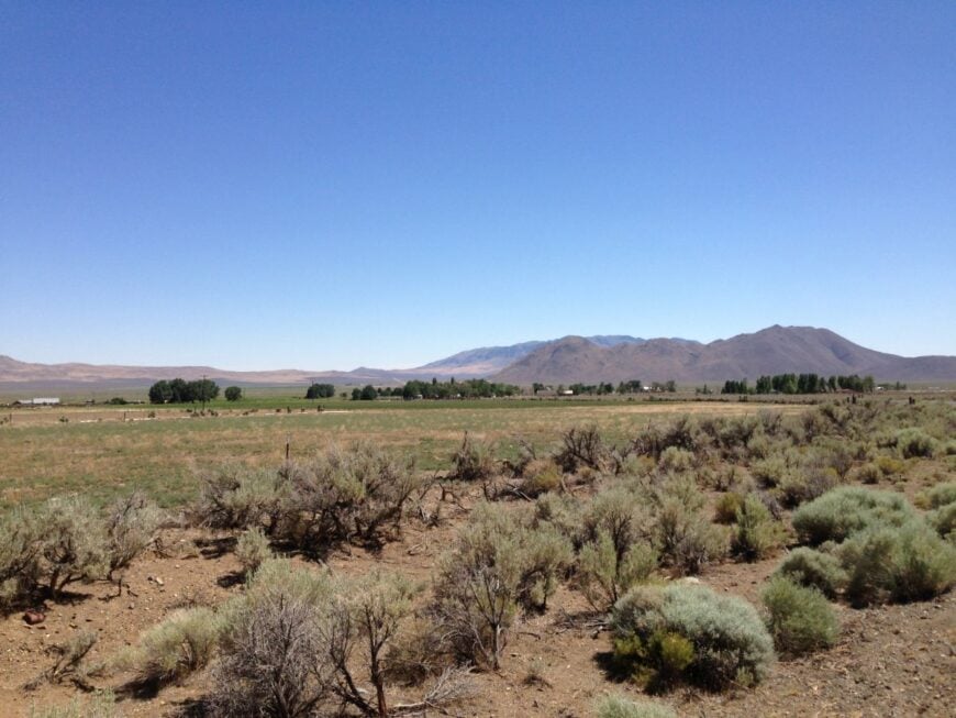
Where is Denio?
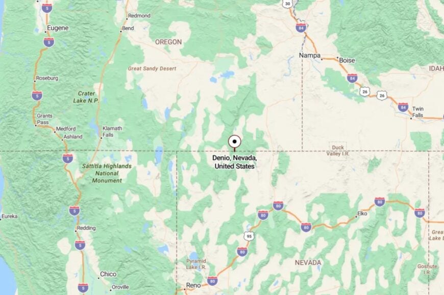
Denio sits in far northwestern Nevada in Humboldt County, right on the Oregon line along US-95. Winnemucca lies about 120 miles south, with little but ranch gates and wide basins in between.
You reach it via a long two-lane ribbon that trades billboards for antelope. Close enough for a weekend, far enough to feel like the map forgot it.
24. McDermitt – Twin-State Main Street on the High Desert
McDermitt straddles the Nevada–Oregon border, a main street with a few cafés and a windswept horizon that goes on forever. Its seclusion comes from distance more than elevation; the next stop of any size is many highway miles away in either direction.
The vibe is straightforward and unhurried—gas, coffee, and long conversations about weather and cattle. Hunt obsidian on nearby lava flats, bird the willow-lined forks of the Quinn River, or take a dirt-road loop toward the Trout Creek Mountains.
Ranching and small-scale mining anchor the economy, with travelers adding a trickle. After sunset, the desert cools fast, and the sky fills from edge to edge. You leave with dust on your boots and peace in your head.
Where is McDermitt?

Perched on US-95 at Nevada’s far northwest tip, McDermitt is about 73 miles north of Winnemucca. There’s no interstate nearby, just a two-lane highway and a lot of sky.
Approaches are simple but long, and winter storms can briefly close passes. It’s close to the road, yet far from everything else.
23. Orovada – Alfalfa Fields Beneath Red Rock Rims
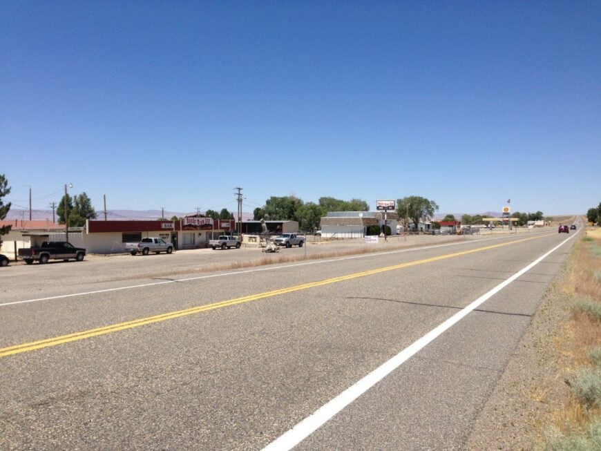
Orovada is an agricultural hamlet on the Owyhee Basin’s southern edge where sprinklers gleam in the evening sun and hawks sit every other power pole. It feels tucked away because fields, BLM ground, and long river miles surround it in every direction.
The vibe is work-first and friendly: feed store talk, school ballgames, and quiet gravel lanes after dark. Drive out to the Owyhee River for trout, watch sandhill cranes in spring, or roam dirt roads toward the Santa Rosa foothills for big-sky panoramas.
Most livelihoods are tied to hay, cattle, and a few service shops on the highway. When the pivots shut down, you can hear the wind move through alfalfa like surf. Out here, there’s always room to breathe.
Where is Orovada?
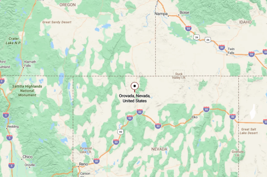
Orovada sits on US-95 about 42 miles north of Winnemucca in Humboldt County. It’s a straight, lightly trafficked run with no suburbs or strip malls to break the view.
Side roads become gravel quickly, and everything beyond turns to open range. You arrive by two-lane, and you stay because the horizon feels endless.
22. Empire – Company-Town Comeback on the Playa’s Doorstep
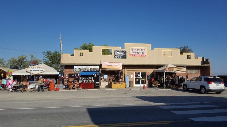
Empire, once shuttered when the gypsum mine closed, has slowly reawakened—a tight grid of houses, a store, and the old plant against a backdrop of white playa. It’s secluded because there’s nothing between it and Reno but long highways and open reservation lands.
The feel is frontier-practical with a hint of optimism: new paint on old porches, work whistles, and the desert’s hush at the edge of town. Wander the margins of the Black Rock Desert, photograph mirages along the flats, or day-trip to the painted terraces near Fly Geyser (on private land, tours required).
Mining and support services provide most paychecks, with festival season adding a brief pulse. Even then, evenings fold back into wind and crickets. Empire is a reminder that solitude and community can share a fence line.
Where is Empire?
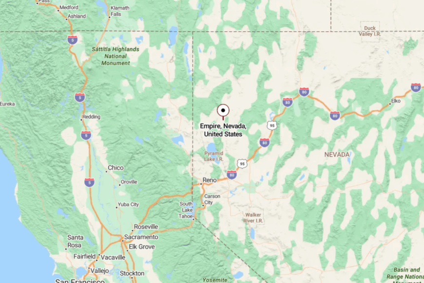
In northern Washoe County, Empire sits on NV-447 about six miles south of Gerlach. It’s a two-hour drive north of Reno with no alternate paved routes.
Beyond town, roads thin to ranch tracks and playa crossings. The last mile feels like you’re rolling off the map.
21. Nixon – Cultural Heart on Pyramid Lake’s Shore
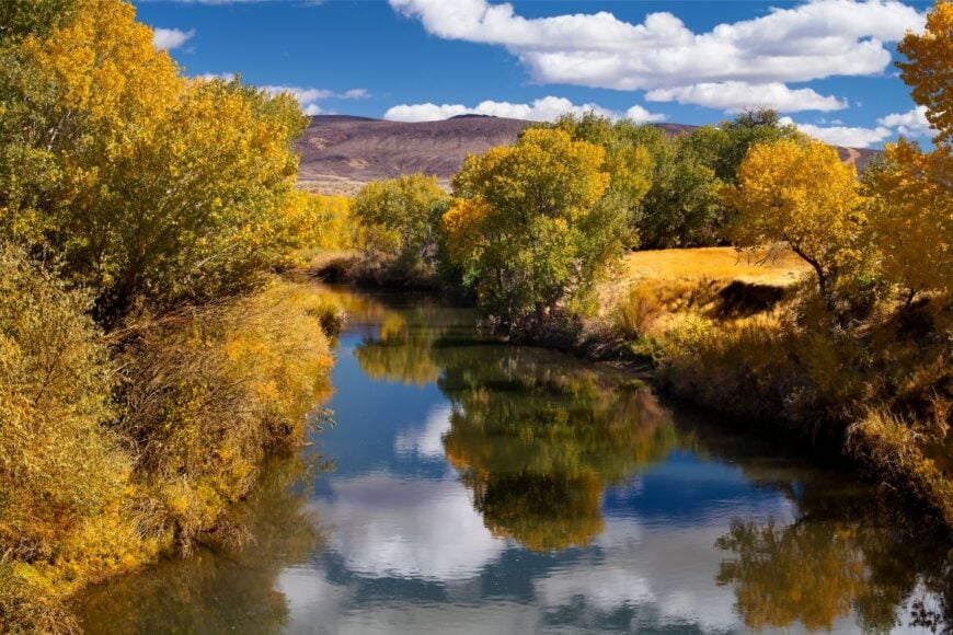
Nixon clusters around its tribal offices, museum, and a few storefronts set back from the turquoise sweep of Pyramid Lake. It feels removed because the reservation limits development, and distances are measured in valleys, not traffic lights.
The vibe is respectful and grounded—museum visits, family barbecues, and quiet shorelines where pelicans surf thermals. Browse the Pyramid Lake Paiute Tribe Museum & Visitor Center, fish for Lahontan cutthroat with a permit, or photograph the lake’s changing blues from sunrise to moonrise.
Work centers on tribal services, education, and guiding. When dusk comes, the lake turns to glass and conversation drops to a murmur. The stillness lingers long after you leave.
Where is Nixon?
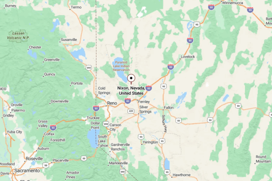
Nixon sits in Washoe County on the southeastern shore of Pyramid Lake, roughly 35 miles northeast of Reno–Sparks. You reach it via NV-447 through open hills and lake vistas.
Side roads quickly become gravel, and many areas are restricted, preserving the hush. It’s close to the metro—yet it feels a world away.
20. Vya – Edge-of-the-Map Ghost Town and Dark-Sky Country
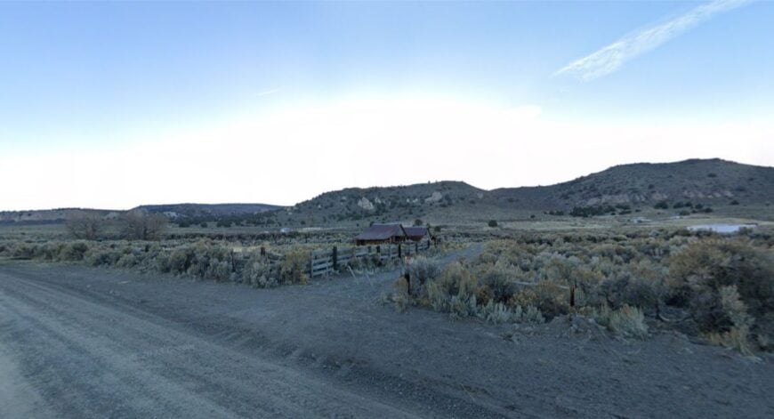
Vya is more suggestion than settlement: a few weathered structures, an old corral, and miles of two-track sliding toward California. Its seclusion is absolute—surrounded by sage seas and volcanic ridges with the Massacre Rim Dark Sky Sanctuary just beyond.
The mood is cinematic: wind in wire, meadowlarks, and a silence so complete you hear your own heartbeat. Search for petroglyphs on nearby basalt, camp beneath outrageous stars, or roam the Rim’s rim for wildflower bursts.
There’s no local economy—just ranch gates and the distant hum of overland rigs. Sunset pours molten light across empty basins. Vya feels like the West paused here and forgot to restart.
Where is Vya?
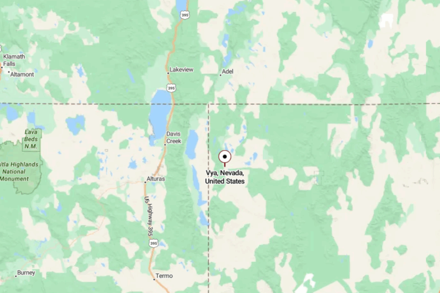
Tucked in far northwestern Washoe County near the California line, Vya is reached by graded gravel from NV-8A and distant NV-140. The nearest services are many miles away in Cedarville, CA, or Denio, NV.
Washboards, mud after storms, and winter closures keep casual visitors out. It’s close enough for the prepared, and perfect for the stars.
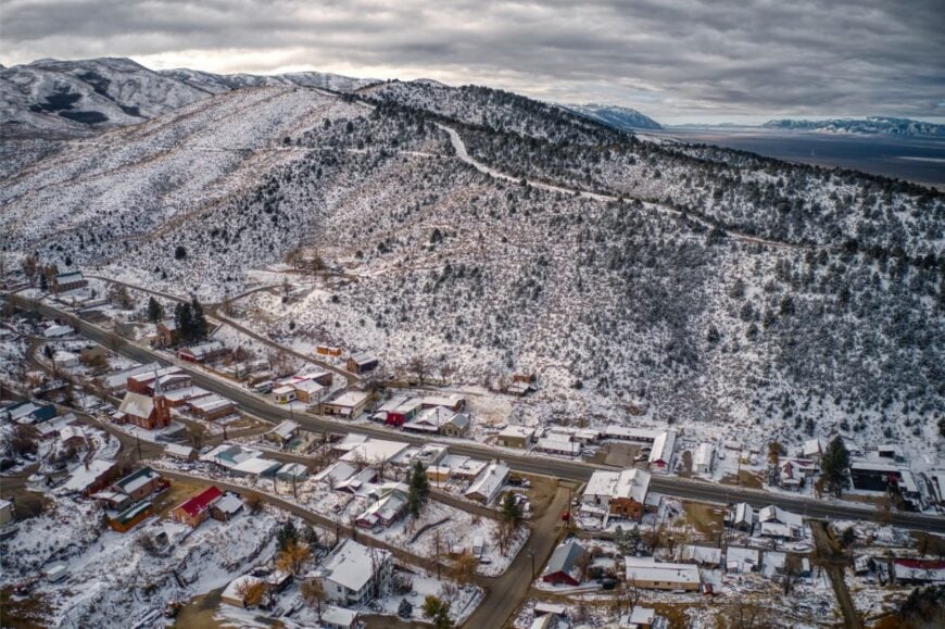
19. Austin – Stone Steeples on a High Ridge of US-50
🔥 Would you like to save this?
Austin rides a mountain spine like a fortress—stone churches, steep streets, and a view that runs to forever. It’s secluded because every approach is a long pull over passes, and the Loneliest Road shrugs off big-city urgency.
The vibe is historic and hardy: antique shops, a mineral museum, and hikers in dusty boots swapping pass conditions. Climb to Stokes Castle for sunset, hike to groves in the Toiyabes, tour the old courthouse, or soak at Spencer Hot Springs across the valley.
Mining heritage and small hospitality outfits share the payroll. At night, the town glows like a ship on a dark sea of sage. Austin teaches you to like the long way around.
Where is Austin?
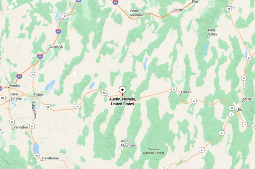
In Lander County, Austin sits roughly midway between Fallon and Ely on US-50. Approaches cross empty basins and top out on cool passes with no alternate freeways.
Once in town, streets pitch steeply up the ridge, and everything else falls away. You feel perched—above noise, above hurry.
18. Kingston – Creek-Side Cottonwoods in Big Smoky Valley
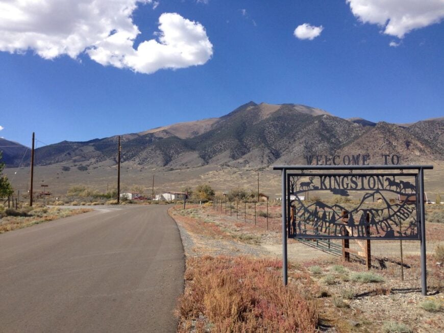
Kingston gathers along a cold creek beneath 11,000-foot peaks, a green ribbon in a wide stone bowl. It stays secluded because it’s at the end of a spur road and backed by the Toiyabe Range’s deep canyons.
The vibe is woodsmoke and porch chairs: dogs asleep on stoops, fly rods by the door, and the sound of water everywhere. Hike the Toiyabe Crest Trail, fish the pools above town, picnic by the old stone school, or drive the dirt over Kingston Summit to wild, empty country.
Jobs are a mix of remote work, small lodging, and ranch chores downvalley. When twilight settles, the creek chatters and the mountains go purple. It feels like a secret campsite someone built into a town.
Where is Kingston?
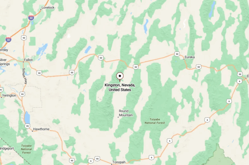
Kingston lies in Lander County off NV-376, about 33 miles south of Austin. The only access is a short but winding spur that dead-ends at the canyon mouth.
No through road means no pass-through traffic—just folks bound for the creek. It’s a small detour that feels like a discovery.
17. Belmont – Courthouse Ruins and Whispering Pinyon
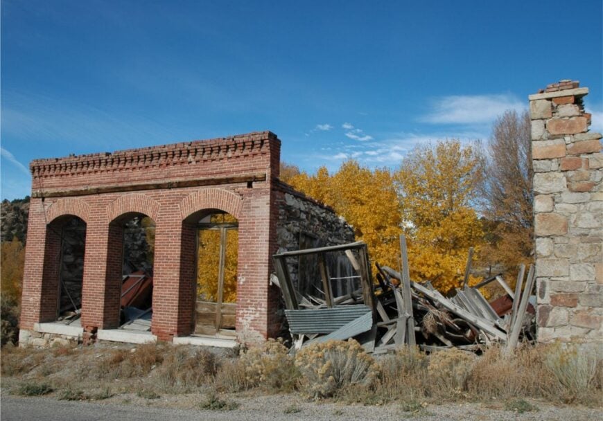
Belmont holds its history close: a proud stone courthouse, brick chimneys, and plank sidewalks that recall silver-boom days. It’s secluded because it sits high and far from main corridors, with miles of piñon-juniper and dirt passes in every direction.
The mood is lightly haunted and welcoming—camp mugs, ghost-town rambles, and stories traded by lantern light. Tour the courthouse, climb the fire lookout, explore charcoal kilns, or soak in quiet tubs at nearby hot springs.
Today’s economy is part caretaker, part weekend innkeeper, part ranch hand. As evening comes, pinyon resin scents the air and nighthawks skim the street. Belmont makes time slow to the pace of footsteps.
Where is Belmont?
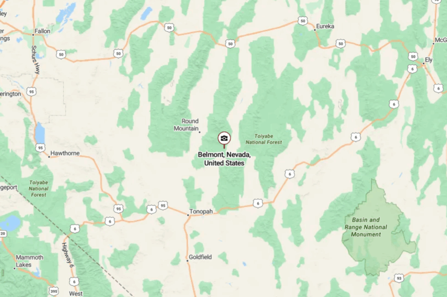
In northern Nye County, northeast of Tonopah, Belmont is reached by graded gravel spurs from US-6 or NV-376. Winter snows and spring mud can close the higher routes.
There’s no fuel on site, only wind and history. You crest a hill and the old courthouse appears like a postcard.
16. Manhattan – A Quiet Cousin in the Smoky Valley
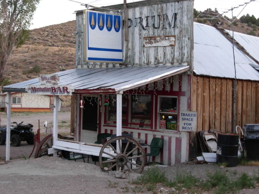
Manhattan tucks against sage hills above a green bottom where cottonwoods whisper all afternoon. It’s secluded because it sits far off US-95 and beyond the attention of casual travelers hustling between Reno and Vegas.
The vibe is neighborly and hand-built—porches, gardens, and a tidy white church that still rings. Walk the old mining streets, photograph stone ruins at daybreak, hunt for agates on nearby slopes, or slip over the pass to remote canyons.
Work comes from ranching, small lodging, and commutes to mines downvalley. Night brings clear constellations and the smell of rain on dust. Manhattan proves you don’t need crowds to have a main street.
Where is Manhattan?
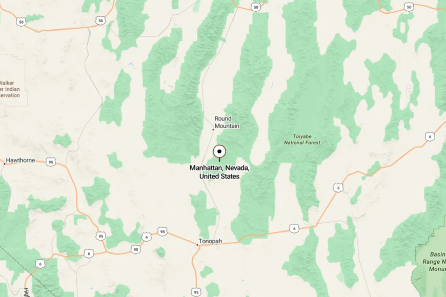
Set in Nye County just east of NV-376, Manhattan is about 50 miles north of Tonopah by a two-lane and graded road. It’s a detour from the fast track with no through route.
Spring snow and summer thunderstorms can make the last miles interesting. You arrive slowly—and that’s the point.
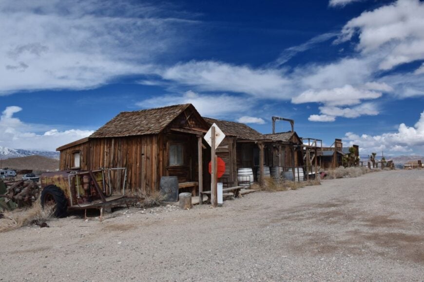
15. Silver Peak – Lithium Brine and a Living Ghost of the West
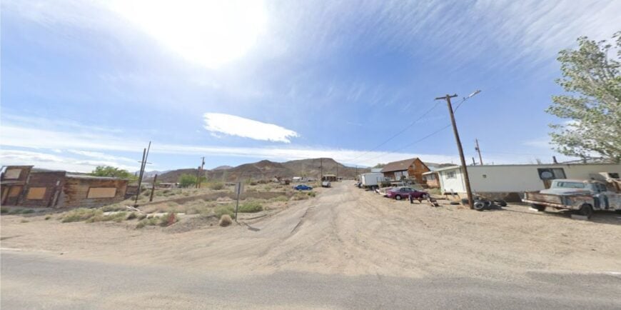
Silver Peak spreads low across alkali flats where evaporation ponds glow teal against pale earth. It feels remote because it’s encircled by BLM land and linked to the world by long, empty roads.
The town’s mood is working-quiet—hard hats at dawn, kids on bikes at dusk, and wind ruffling saltgrass all day. Watch the sun change colors across the brine ponds, explore relic buildings along the original main street, or day-trip to the White Mountains’ foothills for bristlecones and high views.
Mining is the heartbeat here, with a few small services and ranch chores filling in. When the shift whistles stop, you can hear meadowlarks and power lines hum. Silver Peak is industry and isolation sharing the same horizon.
Where is Silver Peak?
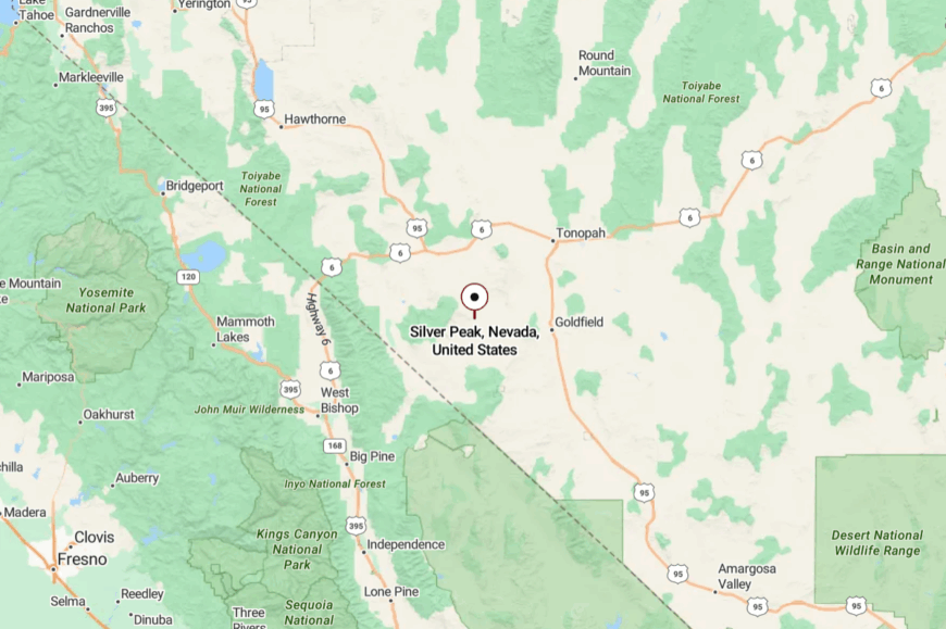
In Esmeralda County, southwest of Tonopah, Silver Peak sits off US-95 via NV-265. The connector runs through open basins with no towns along the way.
Once you turn, it’s all two-lane and then neighborhood streets against the flats. The stark basin light says you’re far from city clocks.
14. Gold Point – Veranda Chairs, False Fronts, and Starry Nights
Gold Point keeps a tidy row of false-front buildings, a saloon that doubles as a museum, and cabins you can sleep in beneath a thousand quiet stars. It’s secluded because it’s far from any highway, and one storm can turn the last miles into a washboard and mud.
The mood is playful-historic—lanterns, camp coffee, and tall tales that get a little taller after sunset. Tour the old stamp mill site, photograph weathered wood at golden hour, hunt turquoise on nearby ridges, or detour to the ghost of Lida.
Today’s income is part heritage lodging, part events, part ranch chores. Coyotes sing, and the Milky Way answers. Gold Point is the postcard you get to walk into.
Where is Gold Point?

Gold Point is in southwestern Esmeralda County, reached by graded roads from US-95 near Lida Junction or from NV-266. There’s no fuel or store, just the saloon and the sky. GPS helps, but locals still read the land. The last turn feels like a handshake with the past.
13. Dyer – Green Fields in a White-Rimmed Valley

🔥 Would you like to save this?
Dyer spreads along Fish Lake Valley, a surprising ribbon of orchards and hayfields ringed by the white shoulders of the White Mountains. Its seclusion comes from being way off the main Reno–Vegas path and hemmed by public lands on three sides.
The vibe is neighborly-agrarian: roadside fruit stands, school games, and long views that calm the mind. Soak at Fish Lake Valley Hot Springs, day-hike to ancient bristlecones over the state line, hunt for obsidian nodules, or photograph thunderheads piling over Boundary Peak.
Alfalfa, cattle, and a few traveler services keep the lights on. Sunsets paint the Sierra crest in unlikely pinks. Dyer feels like a garden someone planted in the desert and then forgot to advertise.
Where is Dyer?

In far southwestern Esmeralda County near the California line, Dyer is reached via NV-264/266 from US-95 or from Bishop, CA. The last hour is all basin and range—no traffic, just mountains shouldering the road.
Winter storms and spring run-off can briefly complicate passes. You arrive between white peaks and a wide sky.
12. Mina – Rail-Stop Relic on a Broad Sage Flat

Mina is a dot on US-95 where the railroad once mattered and the desert still does. It feels secluded because the nearest bustle is many miles away, and the town sits low in a basin ringed by blue ridges.
The vibe is quiet and resilient: a café sign humming in the breeze, quail in the tamarisk, and long freight horns fading into heat shimmer. Rockhound in nearby rhyolite hills, detour to volcanic tuffs at scenic Walker Lake, poke around old depots, or scan for wild burros at dawn.
Work revolves around highway services, ranching, and seasonal construction. Nights here are truly dark—perfect for meteor showers. Mina is a pause button on the modern West.
Where is Mina?

Mina sits in Mineral County on US-95, roughly 35 miles south of Hawthorne and 100 miles north of Tonopah. There’s no interstate—just long two-lane stretches between gas pumps.
Side roads turn to gravel quickly and run straight for miles. The horizon tells you you’re far from hurrying.
11. Luning – Basalt Hills, Big Trains, and Bigger Silence

Luning is a handful of streets tucked under dark basalt hills with the railroad running like a silver thread across the flats. It’s secluded because towns are spaced far on US-95 and there’s little to stop for but sky and stone.
The vibe is open-ended: porch shade, freight rumble, jackrabbits at the edge of yards. Climb the low hills for sunrise, ramble ghost sites to the west, beachcomb the shores of nearby Walker Lake, or scan the night for satellites arcing over Orion.
Today’s economy is highway-light—fuel, a few shops, and ranch work beyond the pavement. After dark, you can hear a train two valleys over. Luning is for people who like the long line between here and the horizon.
Where is Luning?

Also in Mineral County, Luning sits about 30 miles west of Mina on US-95, midway between Hawthorne and Fallon. Access is simple but sparse—one highway, few turnoffs, and long gaps between services.
The surrounding benchlands keep the town out of sight until you’re nearly there. It’s easy to reach and easier to forget everything you left behind.
10. Gerlach: Last Stop Before the Black Rock Desert

Gerlach counts roughly 130 residents, most of whom watch dust devils twist across the playa like clockwork. Visitors grab a plate of ravioli at Bruno’s Country Club, soak in Soldier Meadows Hot Springs, or photograph the kaleidoscopic terraces of the nearby Fly Geyser.
Seasonal crowds tied to Burning Man create a brief spike, yet the town’s year-round economy leans on small ranches, a modest BLM field office, and a single gas station that services long-haul adventurers. Artists set up easels along the Granite Range while rockhounds scour ancient lakebeds for opals and trilobites.
Gerlach feels secluded because it sits 104 miles north of Reno with no other supply points in between, surrounded by public land so vast that sunset appears to last twice as long. The weather-beaten storefronts and dirt streets form an island of humanity in a sea of desert silence.
Where is Gerlach?

The town sits in Washoe County at the southern lip of the Black Rock Desert playa. Unpaved ranch roads and a single paved artery, State Route 447, connect it to the rest of Nevada and nothing lies beyond it but dust and sky.
This stark geography keeps cell service scarce and light pollution nearly nonexistent. Travelers reach Gerlach by turning north from Interstate 80 at Wadsworth, then driving two serene hours past Pyramid Lake and rolling sagebrush.
9. Unionville: Mark Twain’s Forgotten Canyon Hideaway

Only about 70 people reside in Unionville, a cottonwood-lined ravine where Mark Twain once failed at silver mining but succeeded in storytelling. Modern visitors picnic near 19th-century stone ruins, fish for rainbow trout in Buena Vista Creek, and watch quail dart through apple orchards first planted by pioneers.
A combination of hobby ranching, bed-and-breakfast rooms, and remote telework supports the sparse economy. Hikers follow the canyon higher into the Humboldt Range, spotting wild burros that wander through abandoned adits.
The town stays secluded because it hides three miles off paved State Route 400 and sits 20 rugged miles from the nearest services in Lovelock. With no streetlights and only a faint trickle of traffic, night skies glow with Milky Way brilliance.
Where is Unionville?

🔥 Would you like to save this?
Unionville nestles on the western flank of Nevada’s Humboldt Range in Pershing County. Steep canyon walls limit road access to a single gravel spur that dead-ends at the old schoolhouse.
Snowy passes to the east and broad alkali flats to the west discourage casual detours. Drivers approach by exiting Interstate 80 at Mill City and following a signed but lonely route through ranchland and sage.
8. Ione: The “City of the Deserted” in the Reese River Valley

Fewer than 40 residents keep Ione on modern maps, sharing a landscape of scattered shacks, a weathered stone schoolhouse, and broad one-acre lots edged by juniper-covered hills. Visitors poke through the intact assay office, hunt for agates on nearby Spanish Peak, or ride ATVs along forgotten stagecoach trails.
The scant economy revolves around ranch work, seasonal construction, and caretaking of historic sites. Amateur astronomers favor the valley’s pitch-black nights, while birders seek out pygmy owls along Sixmile Canyon.
Ione’s isolation stems from its position 70 miles from the closest grocery store in Austin and the fact that every approach road is gravel. Mail arrives only a few times a week, reinforcing the town’s earned nickname, the “City of the Deserted.”
Where is Ione?

The settlement lies in Nye County’s central Reese River Valley, tucked between the Toiyabe and Shoshone Ranges. There is no direct paved link to Interstate 50, so travelers bump along County Road 21 for an hour after leaving Austin.
Surrounding BLM land and grazing allotments prevent suburban creep. Four-wheel-drive vehicles with full fuel tanks are recommended for the final stretch into town.
7. Middlegate: A Roadhouse Hamlet on “The Loneliest Road in America”
Middlegate’s resident count hovers near a dozen, yet the place manages to host a century-old bar, a handful of weathered cabins, and Nevada’s most famous Shoe Tree where travelers hang sneakers like desert ornaments.
Guests down buffalo burgers at the roadhouse, then step outside to watch wild mustangs graze beneath the Desert Mountains. Local income flows from the bar, a tiny gas pump, and passing motorcyclists who swear by the homemade pie.
Photographers take sweeping panoramas in every direction, capturing Basin and Range cloudscapes that feel almost painted.
The town feels secluded because no other settlement interrupts the 110-mile stretch between Fallon and Austin on US 50. After dark, wind whistles through telephone wires and stars spill unchecked across the sky.
Where is Middlegate?

Sitting in Churchill County, Middlegate straddles US 50 about 45 miles east of Fallon. North and south lie open military training grounds and sage flats with zero residential development.
The only way in is the highway itself, aptly labeled “The Loneliest Road in America” by Life magazine. Drivers simply keep an eye out for a cluster of cottonwoods, a rusting water tower, and a sign promising hot food.
6. Dixie Valley: Empty Homesteads Beneath the Clan Alpine Mountains
No permanent population is officially recorded for Dixie Valley, though a few caretakers and photographers camp near the skeletal barns that survive from an abandoned 1950s farming co-op.
Visitors explore geothermal steam vents, track pronghorn across miles of untouched grassland, and listen for jets from the distant Navy range that occasionally echo through the basin.
There is no formal economy, only the hum of a remote geothermal plant and the odd film crew chasing “end-of-the-earth” scenery. Birders photograph long-billed curlews, while overlanders test suspension systems on the valley’s endless dirt grids.
Seclusion stems from the lack of any services within 60 miles and the valley’s closure on three sides by the Clan Alpine and Stillwater Ranges. Abandoned irrigation ditches and tumbleweed-lined corrals remind visitors how quickly nature reclaims the high desert.
Where is Dixie Valley?

The site rests northeast of Fallon in Churchill County, bordered by two parallel mountain ranges that funnel weather and limit road options. Access requires turning north off US 50 onto a graded dirt route that can wash out after flash floods.
The nearest fuel and food are back in Fallon, so travelers prepare accordingly. Once inside the basin, gravel tracks branch like spider legs with no signposts, heightening the sense of being utterly alone.
5. Berlin: A Silver-Boom Relic Frozen in Time

Berlin claims zero full-time residents today, though state park rangers manage its cluster of 1890s buildings preserved on a hillside at 6,800 feet. Tourists walk through a 30-stamp mill, peer at miners’ cabins kept exactly as found in 1911, and hike the Ichthyosaur fossil trail two miles uphill.
Park fees and limited merchandise sales replace the silver ore that once paid every wage here. Mountain bikers enjoy quiet single-track loops through juniper and pinon, often spotting mule deer that now outnumber people by a wide margin.
Seclusion is guaranteed by 30 miles of winding pavement from Gabbs with no cell service, gas, or commerce along the way. Once gates close at dusk, only wind and the occasional coyote disturb the silence.
Where is Berlin?

Berlin lies inside Berlin-Ichthyosaur State Park in Nye County, halfway between the Shoshone and Toiyabe Ranges. State Route 844 darts south from tiny Gabbs and ends at the park boundary.
Steep switchbacks and winter snow keep traffic minimal for much of the year. Visitors should fill tanks in Fallon or Austin, then enjoy an hour of high-desert scenery before the ghost town comes into view.
4. Sutcliffe: Quiet Shores on Pyramid Lake’s Rugged Edge

Sutcliffe hosts roughly 250 residents whose homes scatter along the western shore of turquoise Pyramid Lake, protected under the Pyramid Lake Paiute Reservation. Anglers chase world-record Lahontan cutthroat trout, photographers marvel at tufa pinnacles like Stone Mother, and kayakers skirt the sheer cliffs of Popcorn Rock.
The local economy centers on tribal fishing permits, small guide outfits, and a marina store where anglers swap stories. Birdwatching shines during spring when vast flocks of American white pelicans swirl above Anaho Island.
Seclusion arises from reservation restrictions that limit development, plus the fact that no towns lie between Sutcliffe and the Reno-Sparks suburbs 35 miles south. Night skies remain so dark that the University of Nevada occasionally brings astronomy students here for lab credit.
Where is Sutcliffe?

Found in Washoe County, Sutcliffe occupies the west-central shoreline of Pyramid Lake at the terminus of State Route 445. Rugged hills hem the town on three sides while the lake blocks expansion to the east.
Apart from a single paved road hugging the shore, every route in is gravel and often gated. Day-trippers reach Sutcliffe by driving north from Sparks for about 45 minutes, passing Nevada’s first ever fish ladders at Marble Bluff Dam along the way.
3. Stillwater: Marshland Oasis Turned Modern Ghost Town
Stillwater’s population has dwindled to fewer than 60 people who occupy ranch houses sprinkled between century-old brick ruins and miles of wetlands. Guests paddle the Stillwater National Wildlife Refuge, spotting ibis, avocets, and once-endangered trumpeter swans while red-winged blackbirds soundtrack the day.
Limited ranching and refuge staffing replace the once-bustling stage stop economy that flourished when this was a mail link to Virginia City. Photographers frame sagging storefronts against shimmering canals and distant Sand Mountain dunes.
The town feels isolated because open pasture stretches 17 miles to Fallon, and flood-prone backroads make winter travel tricky. At sunset, frogs croak louder than any highway hum, sealing Stillwater in almost meditative quiet.
Where is Stillwater?

The settlement sits in Churchill County, east of Fallon and just south of the 80,000-acre refuge that shares its name. County Route 118 provides the only paved access, terminating at the marsh edge.
Seasonal flooding often submerges side roads, further limiting contact with the outside world. Visitors should follow signage from US 50 in Fallon, then keep binoculars ready for the sudden appearance of bald eagles on telephone poles.
2. Gabbs: Mining Town at the End of a Two-Lane Highway
Gabbs is home to roughly 180 residents who cluster around wide streets laid out during a post-war magnesium boom. Travelers stop to view Navy sonar domes at the nearby Berlin-Ichthyosaur fossil quarry, stargaze from the town park’s old baseball field, or hunt for turquoise in the Paradise Range.
The economy relies on the Premier Magnesia mine, part-time ranching, and a small convenience store that doubles as a social hub. Desert racers use Gabbs as a waypoint on the annual Vegas to Reno off-road event, boosting revenue for a weekend each summer.
Seclusion comes from the fact that State Route 361 dead-ends here after 60 lonely miles from US 50, with no alternate routes. The shuttered high school and empty sidewalks give the town an almost cinematic quiet between mine shifts.
Where is Gabbs?

Gabbs sits in Nye County at the northern base of the Paradise Range. Its only paved link is State Route 361, which winds south to Hawthorne or north to US 50 with nothing but wild burros in between.
The surrounding valley is open BLM land, precluding suburban expansion. Drivers planning a visit top off tanks in Fallon or Austin before embarking on the empty stretch.
1. Paradise Valley: Cottonwoods and Cattle Under the Santa Rosas

Paradise Valley supports about 100 residents who tend cattle, alfalfa fields, and heritage apple orchards beneath the 9,700-foot Santa Rosa Peaks. Travelers photograph 19th-century brick storefronts, fish the trout-rich Little Humboldt River, or picnic under cottonwoods that turn gold each October.
Ranching is the sole full-time industry, augmented by small guest cabins and seasonal hunting guides pursuing mule deer and chukar partridge. Horseback riders follow original Pony Express trails while local historians maintain Nevada’s oldest still-operating one-room library.
Seclusion stems from its placement 37 miles north of Winnemucca, accessed by a solitary two-lane spur that crosses open ranchland with zero traffic lights. When evening falls, the only glow comes from kerosene porch lamps and the occasional branding-iron fire.
Where is Paradise Valley?

The community rests at the mouth of its namesake valley in Humboldt County, backed by the towering Santa Rosa Range to the east and broad sage flats to the west. Nevada State Route 290 is the lone access road, ending right at the general store’s weathered porch.
Snow-choked passes and private ranch gates prevent shortcut traffic from Oregon or Idaho. Most visitors begin in Winnemucca, heading north on US 95 before turning east into a green ribbon of farmland that suddenly appears out of the desert.