Southwest Washington is a patchwork of river valleys, timber ridges, and roadside hamlets that rarely make the maps. It is the kind of region where headlights vanish quickly after dusk, and the night sky takes back its authority. The pace is set by tides, logging trucks, and weather that arrives straight off the Pacific.
In order to come up with the very specific design ideas, we create most designs with the assistance of state-of-the-art AI interior design software. Also, assume links that take you off the site are affiliate links such as links to Amazon. this means we may earn a commission if you buy something.
The Columbia River cuts a broad, silver line through the lower edge, while the Cascades push up abrupt walls of forest to the east. Between those borders sit towns that guard their privacy, some founded as lumber camps, others as farming enclaves, each carrying just enough infrastructure to keep going. The distances aren’t vast, but the sense of remove is real.
Isolation here is less about mileage and more about barriers—rivers without bridges, roads that twist through canyons, ridgelines that block cell signals and slow the traveler’s clock. Residents tend gardens, stack wood, and count salmon runs in place of traffic lights. Visitors who stumble in often find the silence startling, as though the land itself insists on a slower tempo.
This survey highlights 25 of those towns, scattered from tidewater outposts near Astoria to foothill settlements beneath Rainier and St. Helens. Each one shows a different way of staying small in a region pressed on all sides by growth, proof that quiet corners still exist where Washington chooses to hold back the world.
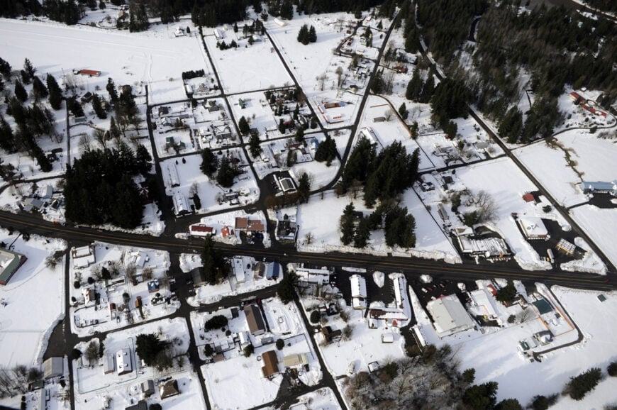
25. Cathlamet – River Town on an Island’s Edge
Cathlamet, with fewer than 600 residents, feels like a secret layered between river channels and wooded bluffs. Its location on the Lower Columbia means the town has always been tied to water, whether through the historic ferry to Oregon or quiet evenings watching ships glide past.
A single main street with a diner, antique shops, and a tiny theater still carries the heartbeat of this riverside community. Kayakers launch from hidden coves, while birdwatchers scan for eagles circling the tidal marshes. Fishing and small tourism ventures provide modest income, but the pace here hasn’t changed in decades.
Evenings settle into the sound of water lapping at pilings, reminding you that river life obeys its own rhythm. It’s the kind of place that feels hushed, as though you’ve stepped into a slower century.
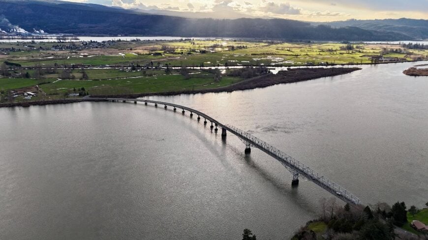
Where is Cathlamet?
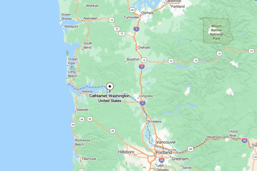
Cathlamet rests in Wahkiakum County, tucked along State Route 4 about 60 miles east of Astoria, Oregon. The town occupies a bluff and river island setting, with the only bridge crossing over to Puget Island.
Visitors reach it by winding riverside highway or by ferry, both of which slow travel. Arriving feels like slipping into a pocket of history where the Columbia River sets the tempo.
24. Carson – Hot Springs Hamlet in the Gorge
Carson hides in the forested folds of the Columbia Gorge, where the scent of cedar mingles with mineral steam from its historic hot springs. Fewer than 3,000 people live here, yet the streets often feel emptier, especially once you wander into the surrounding forest.
Hiking trails lead into the Gifford Pinchot National Forest, while anglers cast into the Wind River. The Carson Hot Springs Resort, with its creaky wooden bathhouse, anchors local tourism, but otherwise the town is a scattering of cabins and cafes.
Logging shaped its past, but today it thrives more on weekend visitors than industry. Nights are still and star-filled, the silence broken only by the river’s low rush. It’s the kind of place that tempts you to linger in quiet water and lose track of the world.
Where is Carson?
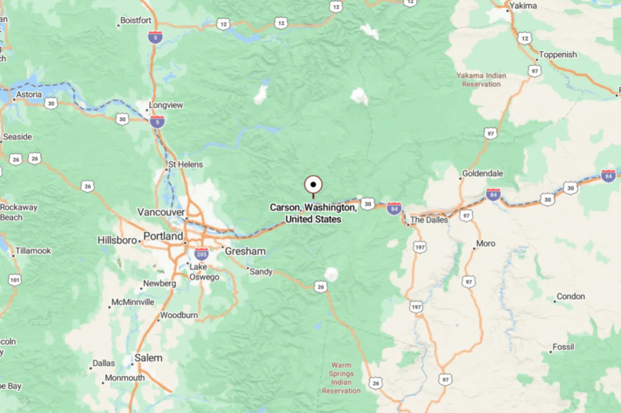
Carson sits on the Washington side of the Gorge in Skamania County, about 50 miles east of Vancouver. It’s accessed by State Route 14, then by a narrow spur road that winds into the trees.
The Columbia River cliffs and forested ridges press close, cutting the community off from sprawl. Arriving here feels like you’ve discovered a hidden clearing in the Gorge itself.
23. Yacolt – Gateway to the Burned Forest
Yacolt’s 1,600 residents live at the doorstep of Yacolt Burn State Forest, where charred history has given way to mossy regrowth and silent trails. This tiny town retains a rural feel, with horses grazing just beyond backyard fences and pickup trucks lining its single business block.
Hikers use Yacolt as a base for waterfalls like Lucia Falls or Moulton Falls, while mountain bikers disappear into the maze of old logging roads. Small sawmills and outdoor outfitters sustain the local economy, but life moves at a gentler pace. Nights bring deep quiet, broken only by owls calling from the forest edge.
Its seclusion lies not in distance, but in the sense of being tucked against miles of woods that have reclaimed their solitude. It’s a town that reminds you how land heals itself, slowly and quietly.
Where is Yacolt?
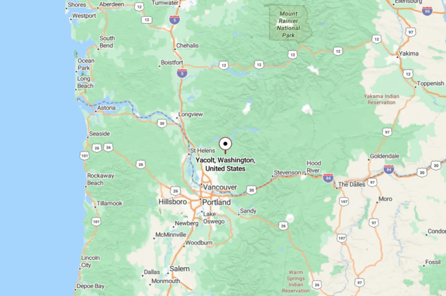
Yacolt is nestled in northern Clark County, about 25 miles northeast of Vancouver. You reach it by county highways that weave through farmland before dissolving into forest lanes.
The steep foothills and dense trees enclose the town, keeping development at bay. Arriving here feels like crossing into a boundary between town life and wilderness.
22. Mossyrock – Valley Town Between Lakes and Hills
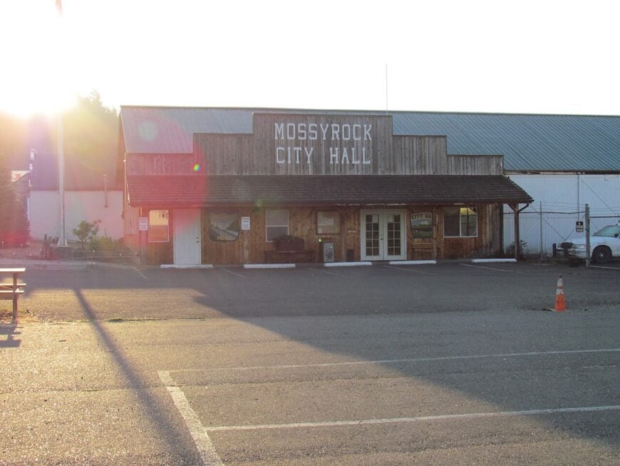
Mossyrock, home to about 800 residents, sits in a fertile valley ringed by the Cascade foothills. Orchards, berry farms, and gardens thrive here, nourished by the Cowlitz River and the mild microclimate. Known as the “Blueberry Capital of Washington,” its annual festival fills the town with parades, pie contests, and music that carries across the fields.
Life is tied to the land and nearby waters. Anglers head for Riffe Lake and Mayfield Lake, both minutes away, while hikers use Mossyrock as a base for trails that wind toward Mount Rainier. The main street holds diners, antique shops, and a small museum in the historic community hall, lending the place a center of gravity despite its modest size.
Evenings bring a soft quiet, broken only by crickets in summer or the low thrum of trains on distant tracks. Mossyrock feels like a valley pocket where modern Washington slows down and takes its time.
Where is Mossyrock?
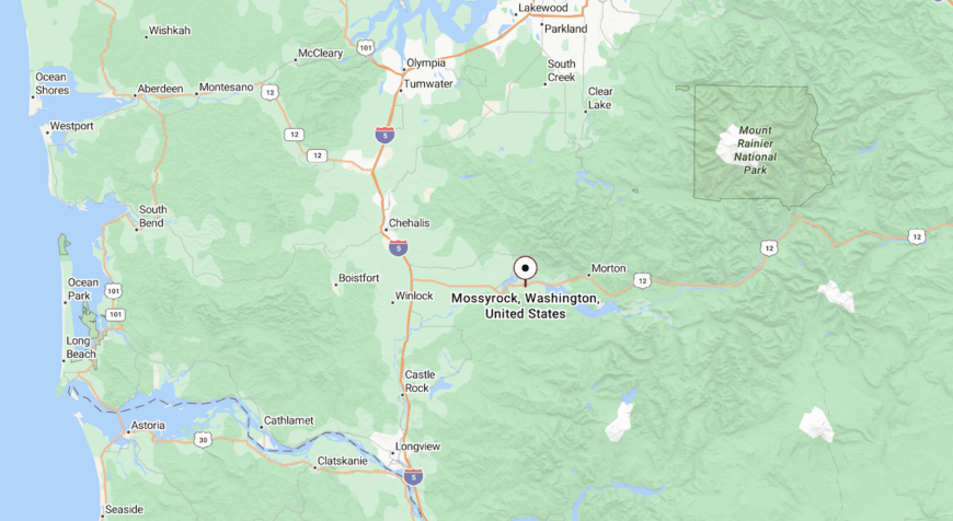
Mossyrock lies in central Lewis County along U.S. Highway 12, about 20 miles east of I-5 at Chehalis and halfway between Mount St. Helens and Mount Rainier. The town sits just north of Riffe Lake and south of Mayfield Lake, with the Tilton and Cowlitz Rivers threading the valley.
Highway 12 provides the only through route, a winding corridor lined with farmland, timber stands, and lakefront turnouts. Though accessible, the geography of steep ridges and wide reservoirs isolates Mossyrock from heavy traffic, preserving its small-town atmosphere.
21. Kalama – Timber Port Turned Quiet Retreat
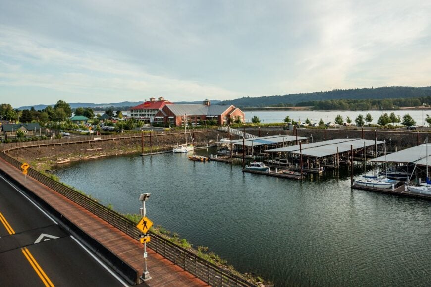
Kalama may be visible from I-5, but its heart lies down at the river’s edge, where old timber docks and fishing piers whisper of busier times. With about 3,500 residents, it retains a working-class charm but feels removed once you leave the highway.
Visitors stroll the riverside park, watch freighters slip past, or explore the quirky shops clustered in historic brick storefronts. Small logging outfits and river traffic once powered the town, but now tourism and retirees keep it steady. Evenings bring a hush over the docks, with only gulls and the distant rumble of passing trains.
Though close to the interstate, the river and bluffs shield Kalama, preserving its slower rhythm. It’s a town that lures you to sit by the water and simply watch the world go by.
Where is Kalama?
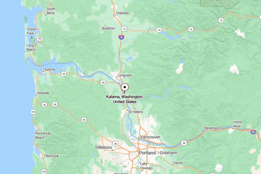
Kalama sits on the Columbia River in Cowlitz County, about 30 miles north of Vancouver. While I-5 runs above the town, access comes from steep downhill streets that separate it from through traffic.
The riverfront location hems it in, giving it a pocketed, tucked-away feel. Arriving feels like descending into a riverside time capsule.
20. Doty – A Timber Village Hidden in the Hills
Doty, with fewer than 300 people, nestles in the Chehalis River Valley where forested ridges rise on every side. The town grew around lumber mills, and remnants of that industry still stand, moss-covered and quiet.
Days are filled with fishing or kayaking on the slow Chehalis, or exploring Rainbow Falls State Park’s cascades nearby. A single general store, post office, and community hall anchor daily life. Economic activity remains tied to timber and small farms, but the pace has always been measured.
At night, the valley’s darkness deepens into near silence, with only the river’s whisper carrying through. It’s a place that feels sealed off by green walls, timeless and calm.
Where is Doty?
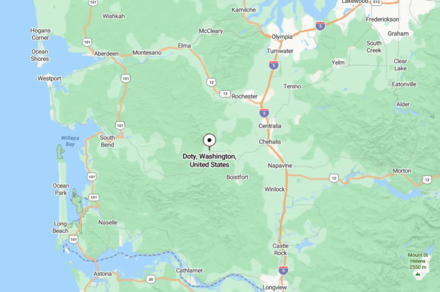
Doty lies in Lewis County, about 20 miles west of Chehalis. It’s accessed by curving two-lane roads that thread through farmland and forest.
The hills rise close, hiding the town from outside view. Arriving feels like discovering a pocket that was never meant to be found quickly.
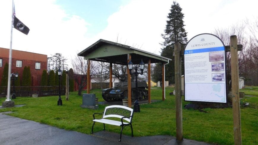
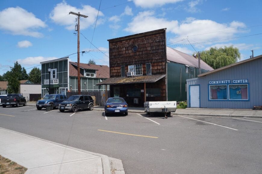
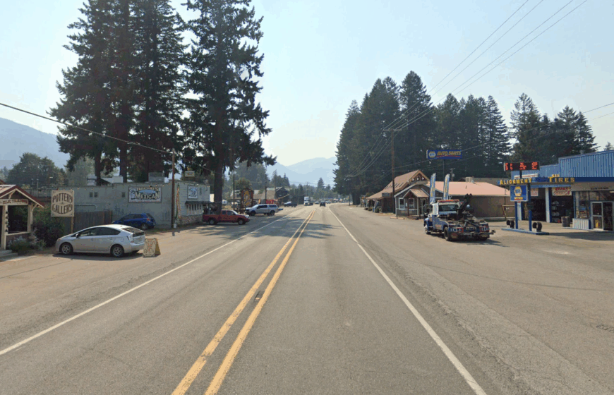
19. Pe Ell – Crossroads Hamlet with Logging Roots
🔥 Would you like to save this?
Pe Ell’s 600 residents live in a bend of the Chehalis River, where time seems to lag behind the outside world. Once a logging hub, its few businesses now include a diner, a tavern, and a scattering of shops along Main Street.
Locals gather for high school ballgames, community fairs, or Sunday fishing along the river. Surrounding hills keep the town cradled, with winding roads deterring hurried traffic. Small logging outfits and farming still provide a living, but the feel is resolutely rural.
When dusk settles, the quiet is nearly complete, broken only by crickets and passing trains. It’s a place where community lingers strong precisely because the world rushes by elsewhere.
Where is Pe Ell?
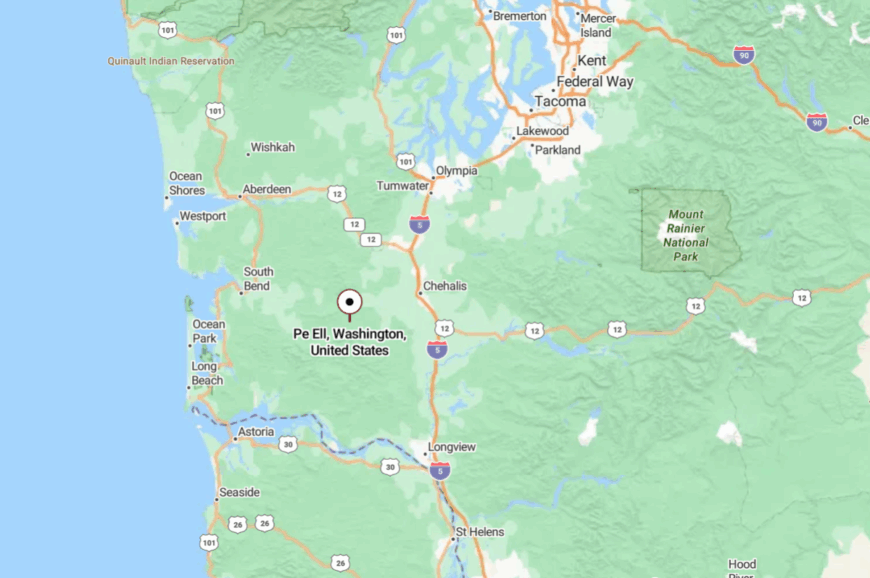
Pe Ell sits in western Lewis County, about 30 miles from Chehalis. It’s reached only by narrow highways winding through farmland and timber tracts.
The valley’s folds keep it hidden until you suddenly emerge into town. Getting there feels like crossing a forgotten boundary.
18. Vader – A Sleepy Stop in the Cowlitz Valley
Vader, with just over 700 people, feels like a village left behind by time. Its brick storefronts and small church steeples whisper of a busier past, when the timber industry thrived here.
Today, residents keep gardens, run small shops, and host annual community festivals in the park. Visitors explore nearby Ike Kinswa State Park, fish the Tilton River, or simply wander its quiet streets. Farming and small trades sustain the economy, but the prevailing mood is one of stillness.
Nights are calm, with porch lights glowing faintly against the dark ridges. Vader feels like the kind of town you stumble on, then remember long after leaving.
Where is Vader?
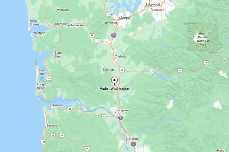
Vader is located in southern Lewis County, about 20 miles south of Chehalis near I-5. Despite its proximity, the town lies on a side road, bypassed by most travelers.
Surrounded by hills and forest, it feels tucked away from the main corridor. Reaching it feels like taking a step off the busy highway and into a quieter era.
17. Winlock – Egg Capital Turned Hidden Hamlet
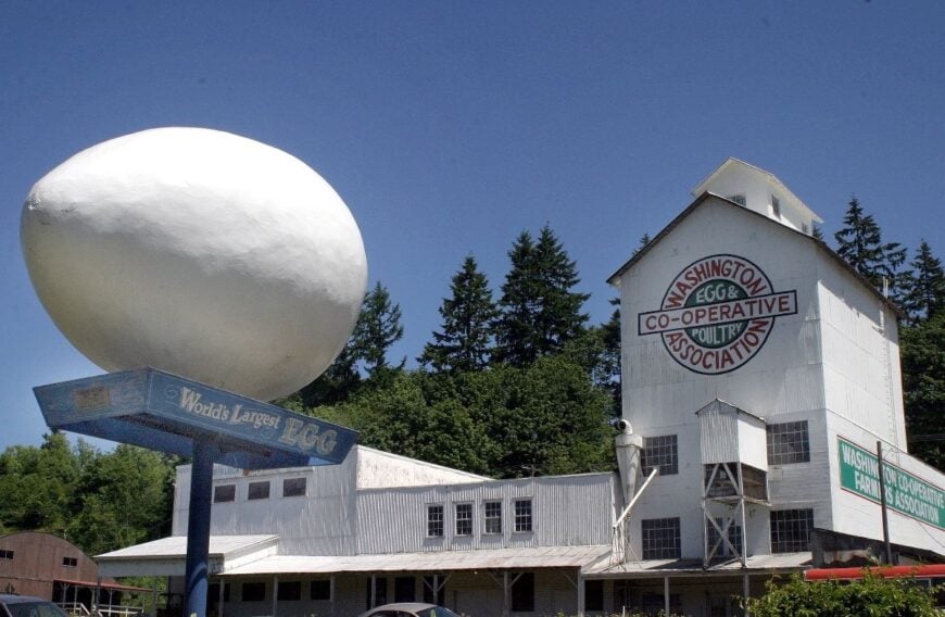
Winlock is known for its giant egg monument, but beyond that quirky claim, this town of about 1,700 feels decidedly secluded. Nestled among rolling pastures and patches of timber, it keeps to its own rhythm.
Residents gather for small-town parades, shop at the farmers market, and linger at the local bakery. The surrounding farmland and chicken ranches shaped its identity, though many now commute short distances for work.
Evenings are quiet, with train whistles drifting through the valley. The absence of big-box stores and rapid growth helps preserve its rural charm. It’s the sort of place where nostalgia and stillness mingle.
Where is Winlock?
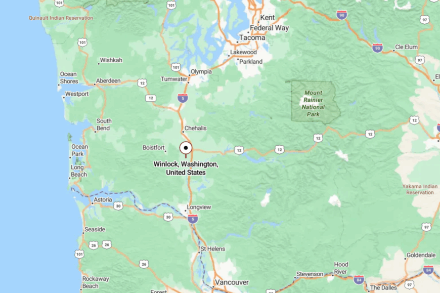
Winlock lies in Lewis County, about 15 miles south of Chehalis and just west of I-5. Though near the interstate, the town’s location on back roads keeps it out of sight.
Rolling farmland buffers it from larger cities. Arriving feels like pulling into a rural fairground that time forgot.
16. Toledo – Riverside Village of Farmers and Fishers
Toledo, with around 800 residents, perches on the banks of the Cowlitz River where salmon runs still set the rhythm. The small main street hosts diners, antique shops, and a weekly farmers market that draws neighbors together.
Kayakers paddle from the town’s riverside park, while anglers test their luck in the salmon-rich waters. Farming remains a major livelihood, with pastures and fields stretching to the horizon. The community feels like a gathering of old friends, slowed by the river’s steady pace.
Evenings bring deep quiet, softened only by frogs calling in the marshes. Toledo carries the gentle feel of a riverside retreat, unchanged by passing decades.
Where is Toledo?

Toledo sits in southern Lewis County, about 20 miles south of Chehalis. Access comes via winding county roads that branch off I-5.
Surrounded by farmland and river bends, it feels pocketed away from larger centers. Arriving is like easing into a riverside storybook.
15. Toutle – Valley Hamlet in St. Helens’ Shadow
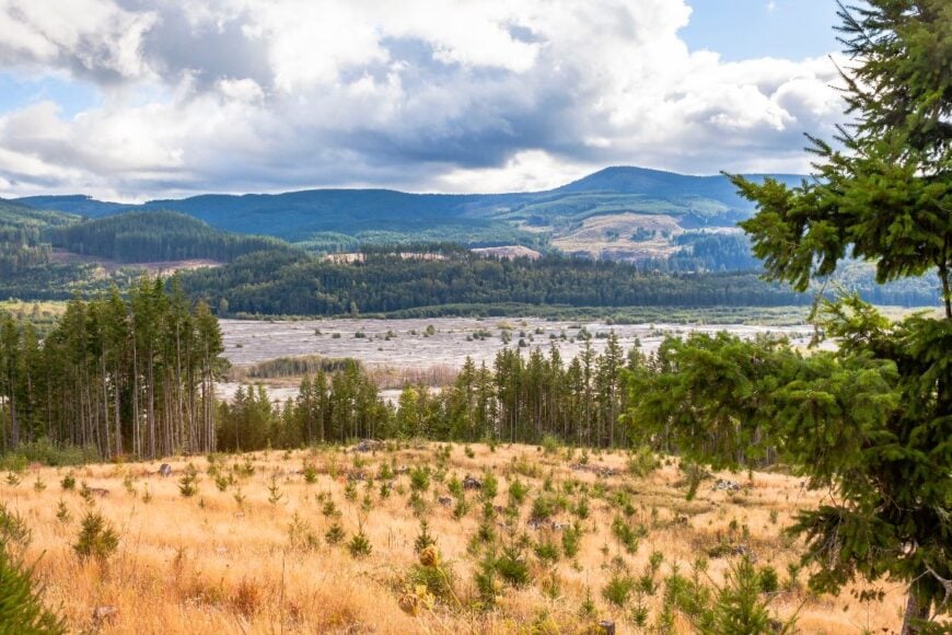
Toutle holds just over 1,000 residents, strung along the Toutle River Valley beneath the looming presence of Mount St. Helens. The 1980 eruption shaped both its landscape and identity, leaving layers of ash and a story told in its small museum.
Today, life revolves around fishing, hiking, and camping in the surrounding forests. A diner, a market, and school buildings make up most of the main drag. Timber and small tourism ventures remain economic anchors, but life here is defined more by nature’s cycles.
Nights bring a heavy quiet, the mountain always visible in silhouette. It’s a town that feels both fragile and resilient at once.
Where is Toutle?
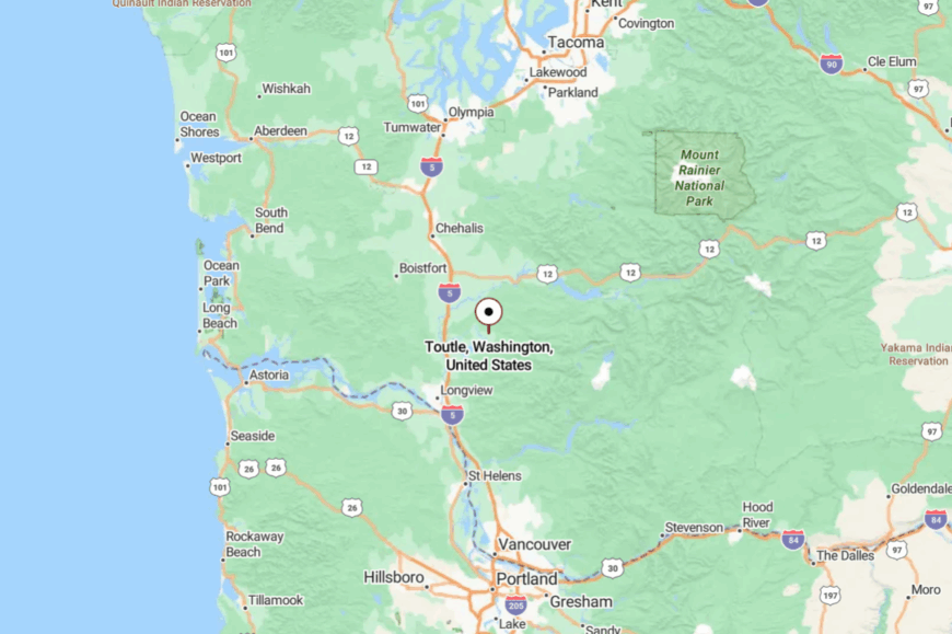
Toutle lies in Cowlitz County, about 20 miles east of Castle Rock. Access comes only via Highway 504, a winding road that eventually leads to the volcano’s blast zone.
Surrounded by ridges and forests, the town feels pocketed from urban life. Arriving feels like crossing into a valley still shaped by fire and regrowth.
14. Deep River – Tide Marsh Cabins at the End of the Road
Deep River is a speck of porches and weathered sheds tucked into alder thickets where the river slows into a broad tide marsh. Fewer than a few dozen households spread along the water’s bends, and the silence feels tidal—coming on slow and leaving slower.
The old Finnish community hall and scattered family farms hint at stubborn roots, even as salmon runs and seasonal rains dictate the rhythm of days. Kayakers slip through reedy channels, photographers chase low fog on winter mornings, and birders scan the sky for eagles coasting the flats.
With no main street and long stretches without services, life centers on home gardens, boat ramps, and a neighbor’s pickup when you truly need something. Logging and small-scale agriculture once defined the economy, but are now replaced by a patchwork of retiree routines and hands-on self-sufficiency. It’s the kind of place where you learn the tide table before you learn your own schedule.
Where is Deep River?

Deep River lies in far western Wahkiakum County, tucked between State Route 4 and the Columbia’s backwaters about 20 miles east of Astoria. You reach it via narrow county lanes that thread along dikes and through mossy cedar groves.
The river, marsh, and enclosing hills keep it off any casual route. It’s close enough to touch the highway, but far enough to feel like you’ve slipped behind the scenery.
13. Stevenson – Gorge Town Wrapped in Cliffs
🔥 Would you like to save this?
Stevenson, with about 1,600 residents, hugs the Washington shore of the Columbia, its streets climbing sharply into wooded hills. The town feels pocketed between cliffs and the river, with little room for expansion.
A brewery, small shops, and riverside parks give it a lively yet contained feel. Visitors hike into Beacon Rock State Park, windsurf the Gorge, or wander the historic downtown. Tourism fuels much of its economy, though the mood remains low-key.
The sense of seclusion comes not from distance, but from the way the cliffs and river hold the town tightly. It’s a place that feels sheltered, like a village hidden in plain sight.
Where is Stevenson?
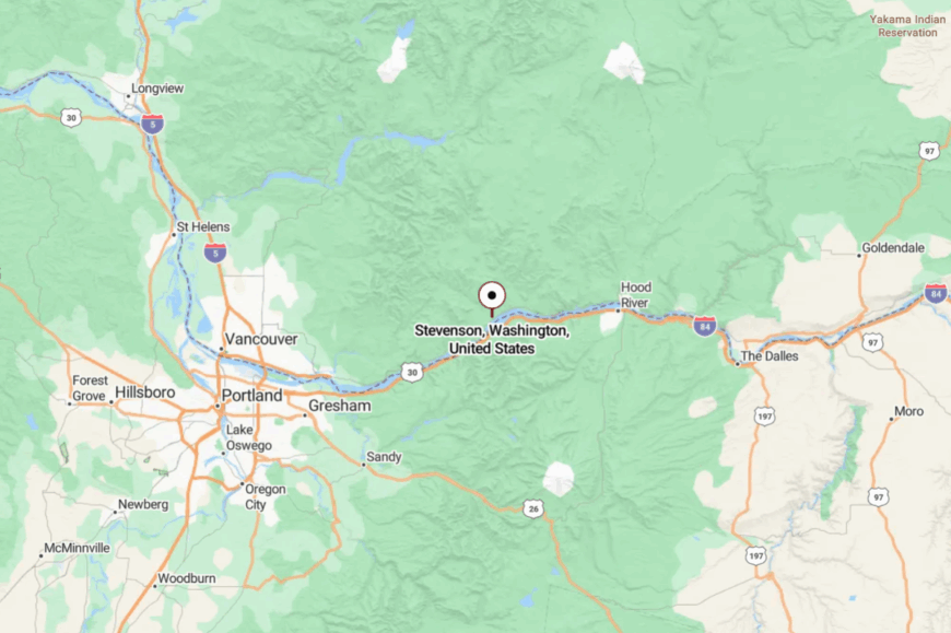
Stevenson lies in Skamania County, about 45 miles east of Vancouver along State Route 14. The Columbia River runs along its edge, with steep cliffs pressing close from the north.
Access requires hugging narrow highway bends with constant views of water and rock. Arriving feels like entering a Gorge-bound pocket world.
12. Altoona – Pilings, Pilchards, and the Wide Columbia
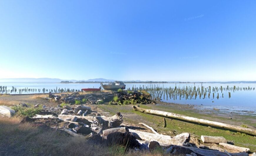
Altoona clings to a lonely bend of the Columbia where cannery days echo in rows of old pilings and salt-stung beams. A handful of houses perch above the tide, facing open water that turns silver under evening light.
There’s no commercial strip—just the river, a boat launch, and the constant company of gulls riding the breeze. Visitors beachcomb at low tide, cast for salmon in season, or walk the shoreline where the river feels as broad as a sea. The air smells faintly of brine and wet wood, and conversations carry far across the flats.
Most folks make do with trips to larger towns, living a rhythm shaped by weather and water rather than schedules. It’s the sort of place that reminds you how small you are beside a working river.
Where is Altoona?
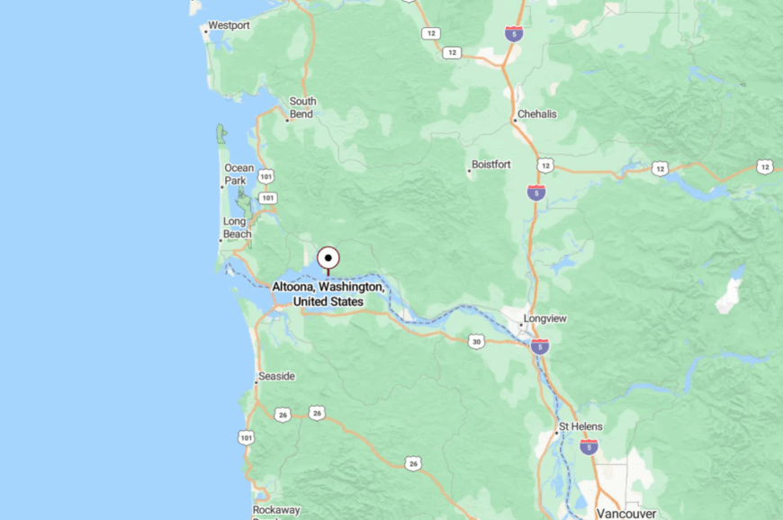
Altoona sits in extreme southwestern Wahkiakum County, roughly 12 miles southwest of Rosburg and well off State Route 4. You reach it by a narrow, winding road that hugs the bank before dead-ending near the pilings.
The river blocks any shortcut, and forested hills press close from behind. It’s close enough to the coast to taste the salt, but far enough to feel like the last stop before open water.
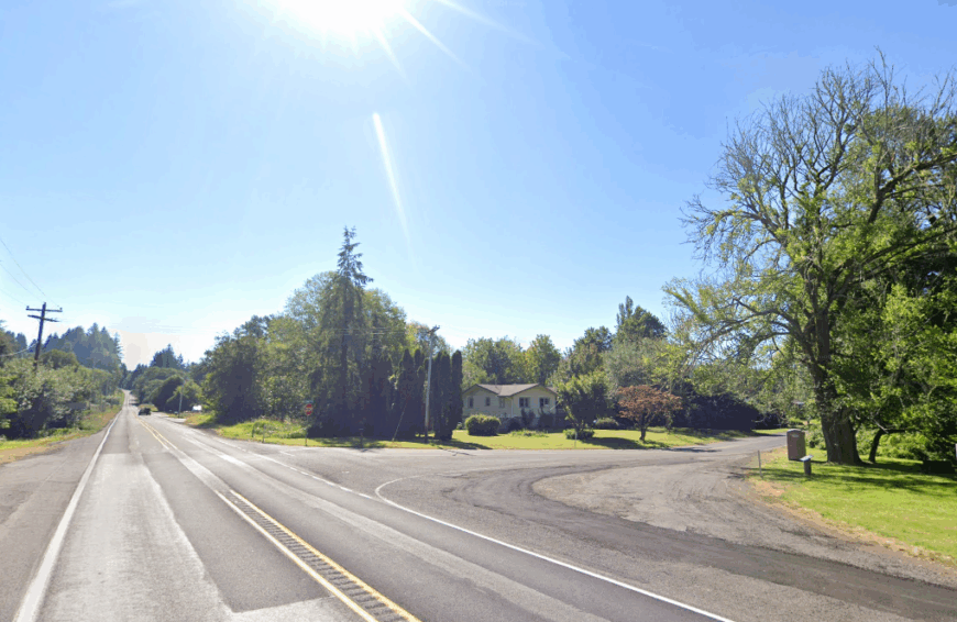
11. Willard – Pines, Creeks, and a Forgotten Mill Site
Willard hides in the north woods of Skamania County, a scattering of homes where tall pines hush the wind and old mill traces linger in the brush. There’s no true business district—just mailboxes on quiet lanes, the occasional saw buzzing, and creeks that run clear even in late summer.
Hikers use Willard as a launch point for the Gifford Pinchot’s lesser-known trails, while anglers test pocket water shaded by cedars. In spring, wildflowers light up old skid roads; in winter, the snowpack muffles every sound but the sweep of wings and a distant woodpecker.
The vibe is practical and rustic: stacked firewood, garden plots, and dogs trotting along gravel drives. Income comes from a mix of remote work, trades, and seasonal recreation, but the forest remains the real anchor. It’s the kind of spot where the map looks empty—and that feels exactly right.
Where is Willard?
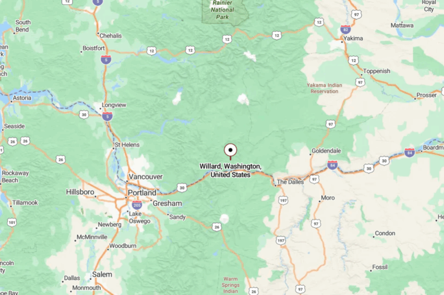
Willard sits about 10 miles north of Stevenson and the Columbia River, up forested roads that peel away from State Route 14. Access winds through canyons and past trailheads, with cell service fading as the trees thicken.
National forest land hems it in, holding back the sprawl of the Gorge’s busier towns. You arrive with dusty fenders and a sense that the world just got wider and quieter.
10. Grays River – Covered-Bridge Country in a Fog-Draped Valley
Roughly 250 people share the pastoral floor of the Grays River valley, a patchwork of hay fields dotted with weathered dairy barns.
Daylight hours invite kayaking on slow-moving sloughs, birdwatching along riverside pastures, and photography sessions at the 1905 Grays River Covered Bridge—the only one left in Washington that still carries traffic.
Small-scale cattle operations and niche organic farms replace the commercial logging that once dominated, keeping economic activity low-key. The lack of chain stores, streetlights, and fast internet deters large-scale growth, preserving a pace that rarely changes with the seasons.
Morning fog often blankets the valley and muffles sound, adding to the sense of being tucked far from modern bustle. Forested ridgelines on every side act as natural walls that separate the community from the nearest sizeable town.
Where is Grays River?
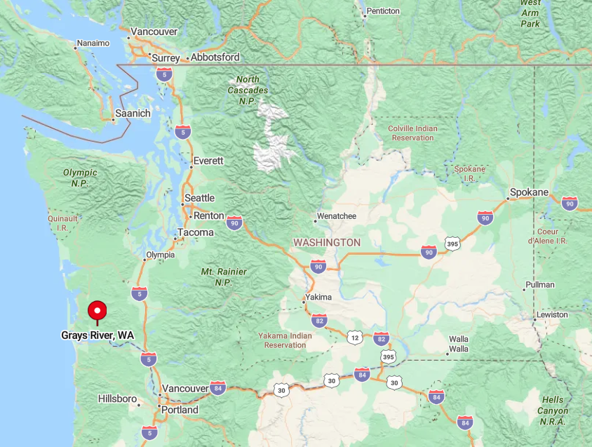
This hamlet sits along State Route 4 in western Wahkiakum County, about 50 miles west of Longview and 30 miles east of the Pacific surf at Long Beach. Heavy timber flanks the winding highway, and the river’s looping course forces drivers to slow, reinforcing its out-of-the-way feel.
The closest full-service airport is Portland International (about two hours away), while Astoria Regional across the Columbia offers limited general aviation and charter flights. Most visitors arrive by car after a scenic but deliberate trip through a labyrinth of levee roads and forest corridors.
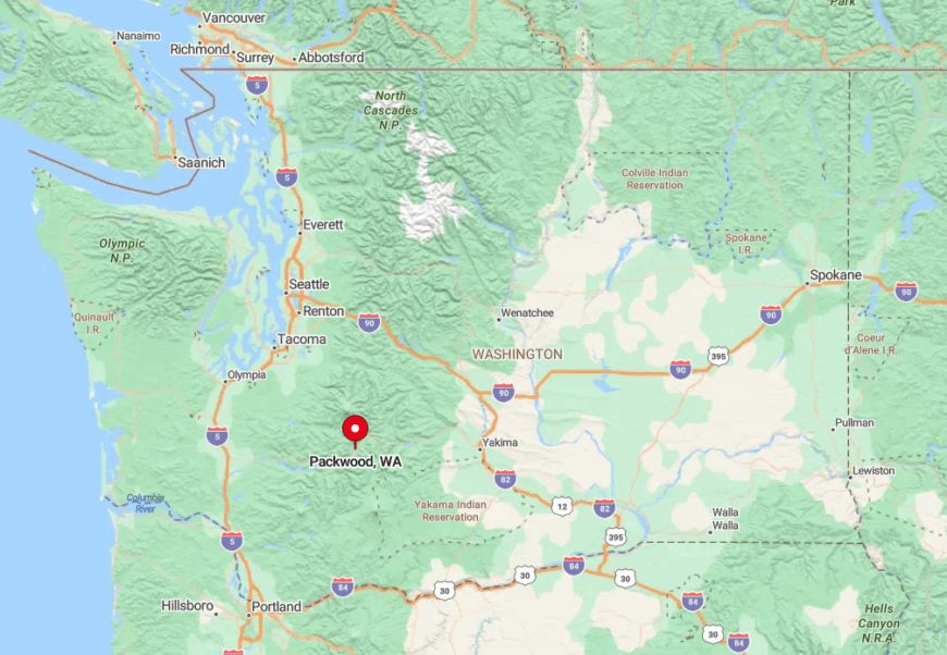
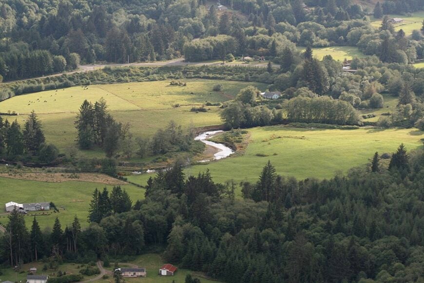
9. Packwood – Elk-Roaming Meadow Hamlet at Rainier’s Doorstep
Packwood’s permanent roster hovers near 1,500, though herds of Roosevelt elk often outnumber people in the broad meadow beside the Cowlitz River. Recreation revolves around hiking to local trails, snowshoeing at White Pass, and browsing the summer flea market that overruns Main Street on holiday weekends.
A handful of outfitters, vacation-rental managers, and seasonal festival vendors sustain the local economy now that large sawmills have closed. Packwood’s remoteness stems from 60 miles of curving Highway 12 separating it from Interstate 5, a stretch prone to winter closures that keeps casual visitors at bay.
Residents enjoy roomy riverfront lots where neighbors are more likely to be deer or elk than other humans. Even during peak tourism, quiet returns as soon as dusk settles behind the snowy crown of Mount Rainier.
Where is Packwood?
🔥 Would you like to save this?
The town rests on the east side of Lewis County, nestled between Mount Rainier National Park to the north and Goat Rocks Wilderness to the south. Steep valleys and federal forestland surround the settlement, preventing suburban sprawl from Centralia or Yakima.
Travelers reach Packwood by driving Highway 12 across White Pass or through the forested Nisqually corridor, routes that demand patience in snow season. Public transit is nonexistent, leaving private vehicles as the only practical means of arrival.
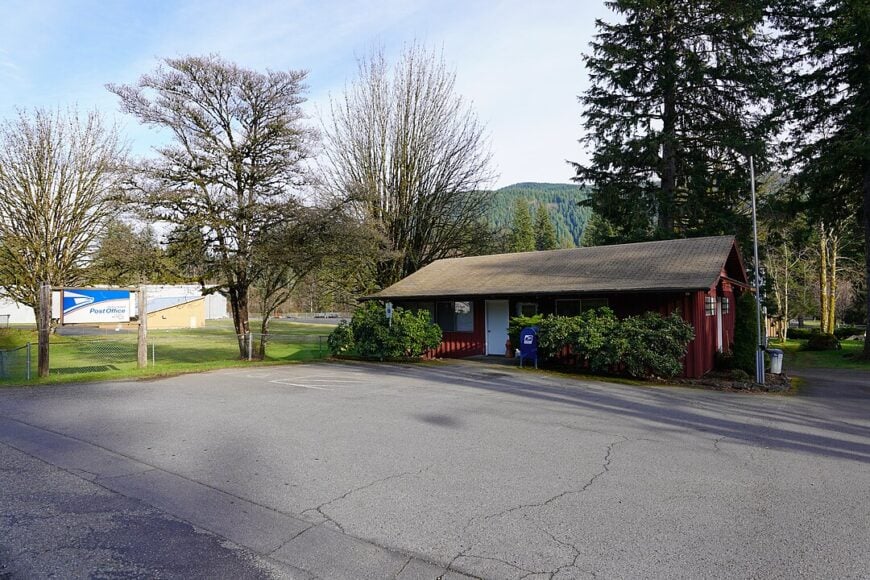
8. Naselle – Finnish Heritage Fields Beside the Willapa Hills
Home to around 400 residents, Naselle balances Scandinavian charm with evergreen solitude. Visitors can tour the Naselle Finnish American Folk Festival grounds, cast for steelhead in the Naselle River, or bike the gentle hills that cradle century-old farmsteads.
Family dairy farms, commercial cranberry bogs, and a small seafood cannery make up the economic backbone. The town’s distance from any four-lane highway and its one-acre zoning slow outside investment and keep views uncluttered by subdivisions.
Winter rains shroud the valley in low-hanging mist, muting sound and reinforcing its tucked-away appeal. Street names still carry Finnish spellings, a reminder of immigrant roots preserved precisely because growth has been modest.
Where is Naselle?
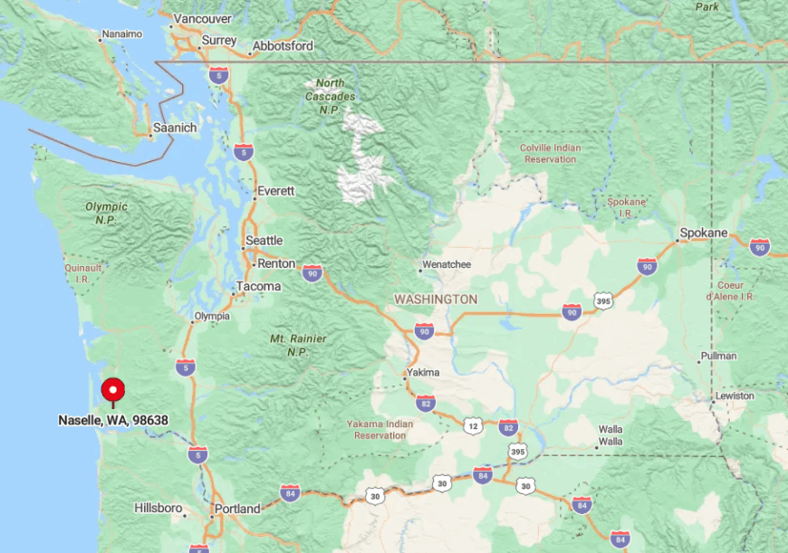
Naselle sits at the junction of State Routes 4 and 401, roughly 25 miles east of Astoria, Oregon, and 90 minutes from either Olympia or Portland. Willapa Hills rise to the east, while tidal flats of Willapa Bay guard the western approach, hemming the town into a narrow corridor.
Drivers coming from Interstate 5 must navigate logging roads or follow the Columbia River westward, both involving long stretches without services. Limited bus links end at Long Beach, making personal vehicles the preferred way to reach this Finnish enclave.
7. Cougar – Spirit Lake Highway’s Last Stop Before the Volcano
Cougar claims a year-round population of about 100, though weekends swell slightly with anglers bound for Yale Lake. Days can be filled with paddleboarding on the reservoir, hiking to Lava Canyon, or sharing stories at the lone café about the 1980 eruption of Mount St. Helens looming overhead.
A small marina, a general store, and private timber holdings provide most local jobs, leaving the rest of the week to quiet reflection in cedar-scented air. Only one paved road leads in, and it dead-ends at national forest gates, eliminating any through traffic.
Cabins perch on wooded acreages behind mossy stone walls, and porch lights are often the only points of illumination for miles. Nightfall brings deep hush, broken only by barred owls and distant waterfalls.
Where is Cougar?
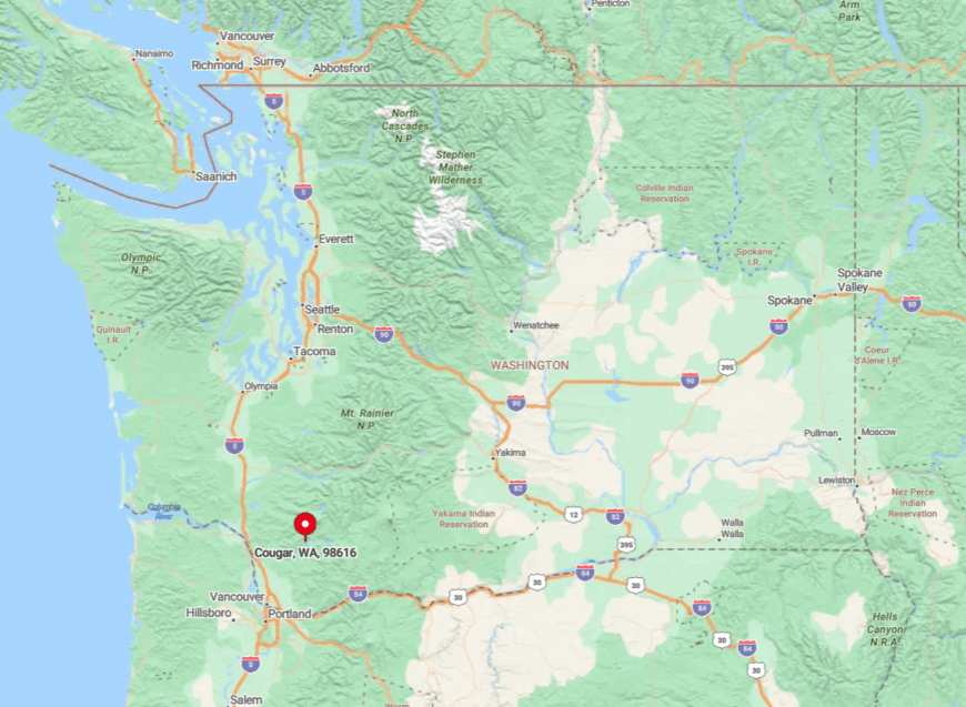
The settlement lies in northern Cowlitz County, 40 miles east of Woodland and Interstate 5, reached solely by State Route 503, also called Spirit Lake Highway. Jagged ridgelines and the vast Mount St. Helens National Volcanic Monument insulate the area from urban advance.
Snow or rockfall can close the road beyond Cougar, enhancing its sense of being the last refuge before true wilderness. Travelers must drive, since no bus or shuttle serves the community, and the nearest railway stop is over an hour away.
6. Skamokawa – Tide-Flat Retreat on the Lower Columbia
About 500 people inhabit Skamokawa, a riverside dot where tide flats stretch toward Oregon’s distant shore. Kayakers weave through protected sloughs, history buffs tour the 1894 Redmen Hall, and birders scan the wetlands for sandhill cranes during migration.
A slim roster of B&B hosts, charter-boat operators, and small dairy farms forms the local job market. Isolation is guaranteed by miles of serpentine levee roads hugging dikes and channels that discourage heavy trucks and RV caravans.
Wide estuarine views mean the nearest neighbor may sit half a mile across a salt-grass meadow. The hush deepens at high tide when water laps against pilings that once supported busy salmon canneries, now long gone.
Where is Skamokawa?
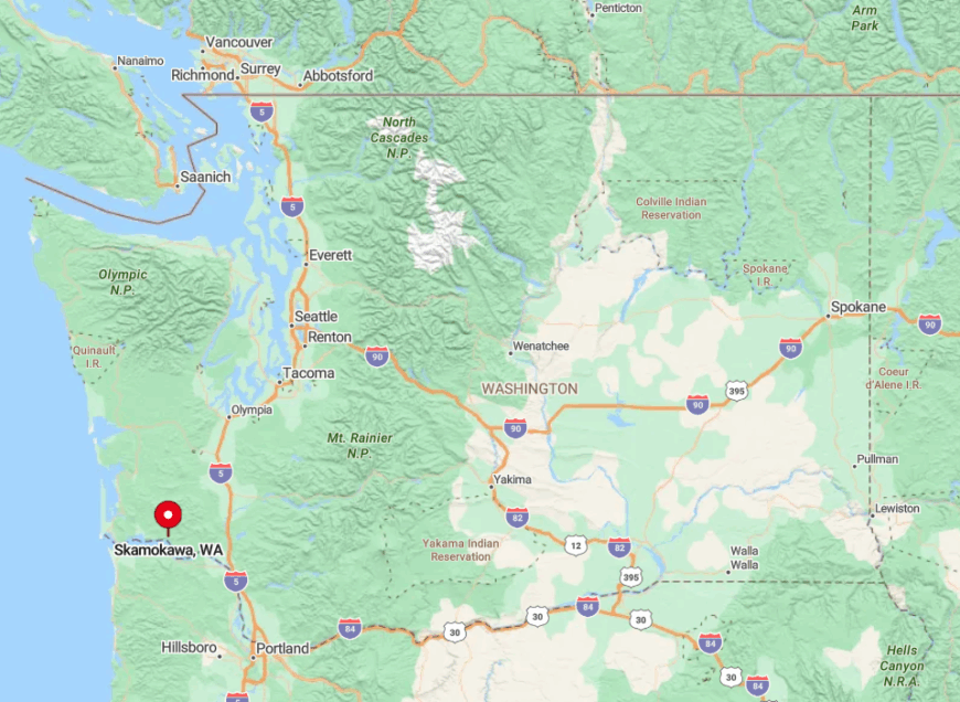
Skamokawa occupies a broad bend of the Columbia River 15 miles west of Cathlamet and roughly 75 miles from Portland. The town is hemmed in by the river to the south and steep, timbered hills to the north, limiting any expansion corridor.
Access comes via State Route 4, followed by a spur of meandering county roads, many of which narrow to a single lane near dairy pastures. No public transit crosses the valley, so first-time visitors usually arrive by car or by kayak from river camps upriver.
5. Randle – Forest-Fringed Crossroads Between Two Volcanoes

Randle hosts nearly 1,700 residents who greet each morning with unobstructed views of snow-streaked Goat Rocks peaks. Popular pastimes include fishing the Cowlitz River, stargazing from high-meadow trailheads, and browsing produce stands along U.S. Highway 12.
Small sawmills, Christmas-tree farms, and seasonal guide services anchor the modest economy. The absence of streetlights along county roads and a 40-mile buffer to the nearest large town preserves dark skies and rural calm.
Flat valley floors offer multi-acre home sites where vegetable gardens rival the size of suburban blocks. Even the main drag closes early, leaving night shift workers to rely on their porch lanterns.
Where is Randle?
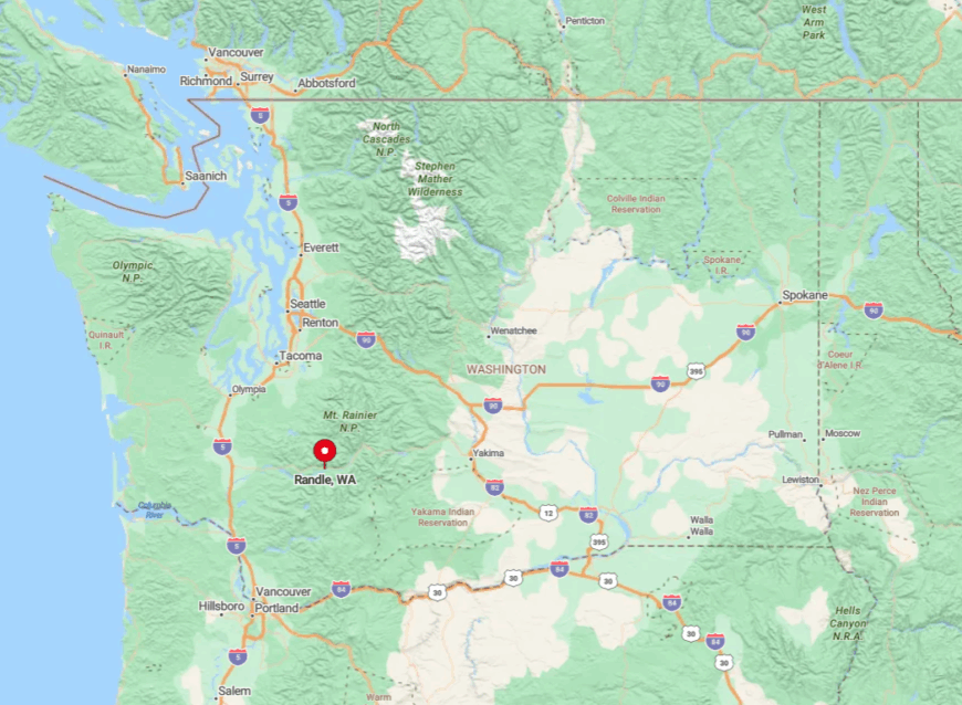
Set midway between Mount St. Helens and Mount Rainier, Randle lies on Highway 12, 55 miles east of I-5 at Chehalis. The Gifford Pinchot National Forest wraps around three sides, absorbing noise and blocking developers.
Winter storms often dust the highway with snow, making the last leg of travel deliberately slow. Aside from limited summertime bus tours to the volcanoes, private vehicles are the sole reliable link to the outside world.
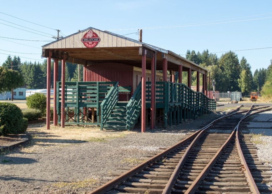
4. Amboy’s Chelatchie Prairie – Horses, Hills, and Endless Evergreens

Approximately 600 people call the Chelatchie Prairie north of Amboy home, many of them tending horses on roomy pastures framed by Douglas fir. Weekends fill with trail rides into the Yacolt Burn State Forest, steam-train excursions from the old depot, and berry picking at U-pick farms that dot the prairie.
Income arises from boutique horse boarding, specialty lumber milling, and home-based artisans rather than big box retail. A 25-mile ribbon of curving county highway separates the prairie from Vancouver’s suburbs, while the Cascade foothills create a natural barricade against large-scale development.
Most roads end in gravel driveways fading into timber, so passing traffic is scarce. Night brings a chorus of tree frogs and a canopy of stars seldom seen near metro centers.
Where is Chelatchie Prairie?
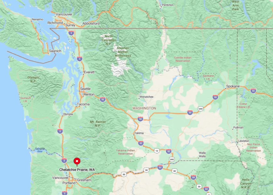
The prairie spreads across northern Clark County, just east of the Lewis River and south of Mount St. Helens. Steep foothills and thick forest borders funnel visitors along a single approach, Northeast Healy Road, adding to its tucked-away setting.
Though Vancouver is only an hour by car, the absence of direct bus routes or rail stops increases travel time and keeps commuter pressure low. Most guests arrive for the seasonal steam-train rides, then marvel at how quickly cell reception fades only minutes off the main pavement.
3. Rosburg – Salmon Streams and Pastureland at River’s Edge
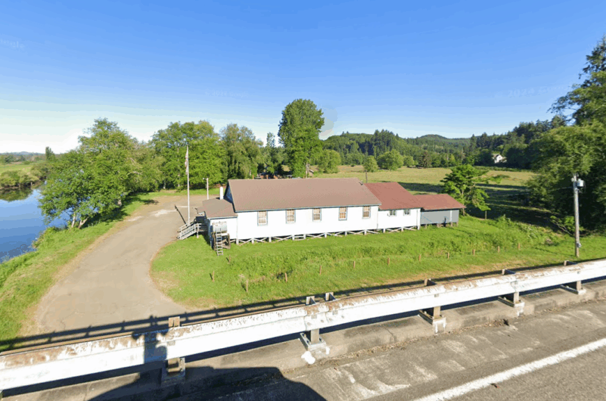
Rosburg’s head count hovers near 300, shared among farmhouses stretching along the Grays River’s sinuous bends. Locals cast for coho under alder canopies, browse heritage tools at Johnson Park Community Center, or swap stories during Friday night chili feeds.
Beef ranching and small-scale timber harvesting remain the chief sources of employment, supplemented by a single convenience store that doubles as a post office. The hamlet’s scatter of homes sits behind reed-choked oxbows and blind curves that ward off hurried drivers.
Dense forest buffers every road, muting any noise beyond the lowing of cattle. Visitors often remark that the loudest sound after dark is the splash of salmon rasping upstream.
Where is Rosburg?
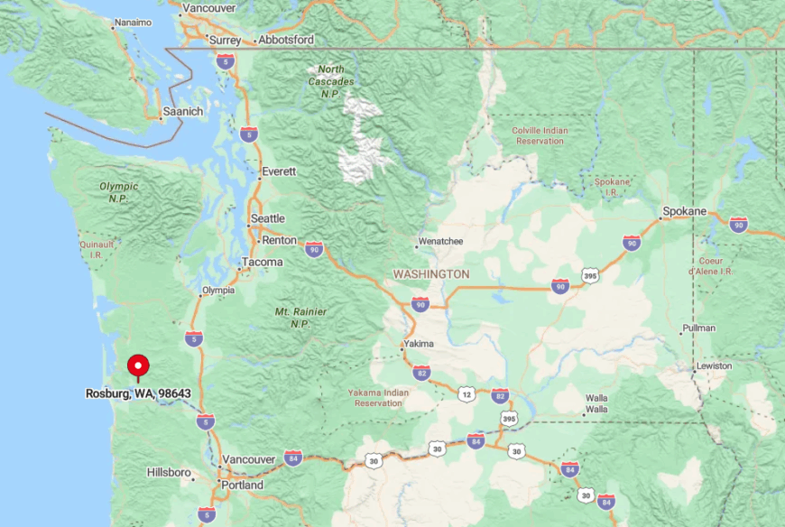
Rosburg lies in western Wahkiakum County, seven meandering miles upstream from Grays River and 60 miles from any interstate. Access involves threading State Route 4, then branching onto Altoona-Pillar Rock Road, a narrow track shadowed by cedars and hairpin turns.
The Columbia River’s tidal reach blocks any shortcut from the south, while steep hills hem in approaches from the north. Private vehicles are essential, as the nearest scheduled bus stop is more than 20 miles away in Cathlamet.
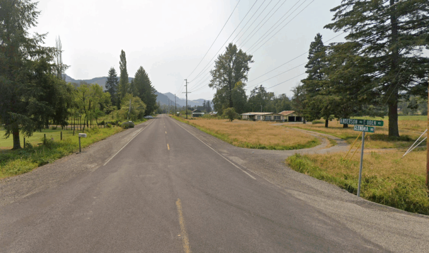
2. Ryderwood – Retiree Haven in a Former Lumber Camp
Around 400 seniors reside behind the whitewashed fences of Ryderwood, a company town built in 1923 and now reserved for those aged 55 and older. Afternoons might involve quilting at the Women’s Club, birdwatching along Cedar Creek, or browsing the miniature museum housed in the former commissary.
Pension checks, cottage rentals, and a modest cafe supply the local economy where logging once reigned. Surrounded by 50 square miles of private timberland and lacking a commercial strip, the town enjoys a stillness broken only by jingling wind chimes.
Wide setbacks between cottages provide garden space while creating an airy streetscape rarely found in modern subdivisions. The absence of through roads prevents stranger traffic, fostering a neighborly environment where everyone waves from the porch swing.
Where is Ryderwood?
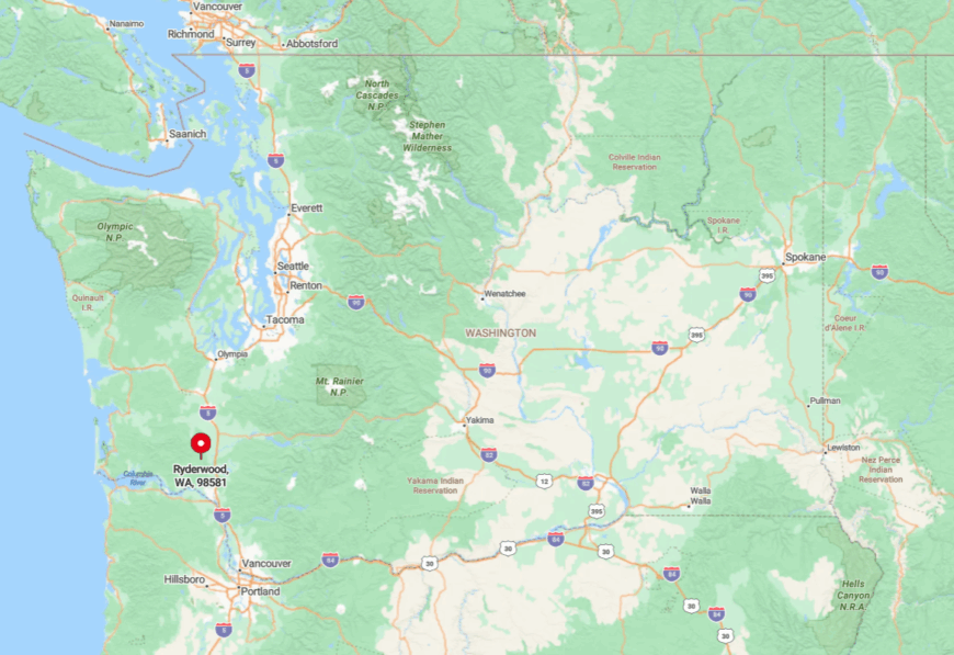
The village is tucked in northern Cowlitz County at the terminus of State Route 506, 16 miles west of I-5’s midpoint near Vader. Forested ridges ring the flat townsite, concealing it from motorists speeding between Seattle and Portland.
Only one road goes in or out, meaning visitors intentionally seek the town rather than stumble upon it. Without bus routes or ride-share coverage, reaching Ryderwood almost always involves a personal car navigating gentle logging-truck curves.
1. Glenoma – Lakeside Farms Beneath Riffe Reservoir Ridges
Glenoma records a population of roughly 700, spread across pastures and woodlots that slope toward the long blue reach of Riffe Lake. Days find residents launching boats at the Kosmos ramp, fishing for trout and bass, or hiking to Layser Cave for ridge-top views of three volcanoes.
Small farms, cattle grazing, and seasonal recreation tied to the lake’s drawdowns form the modest economic mix. Suburban growth never arrives here—checked by the expanse of the reservoir to the south and the Cascade foothills pressing in from the north.
Most homes sit on multi-acre parcels where barn owls hunt the fields and neighbors appear as distant silhouettes across foggy meadows. After sunset, the hum of the Cowlitz Falls Dam is often the only reminder that modern engineering coexists with this otherwise quiet landscape.
Where is Glenoma?
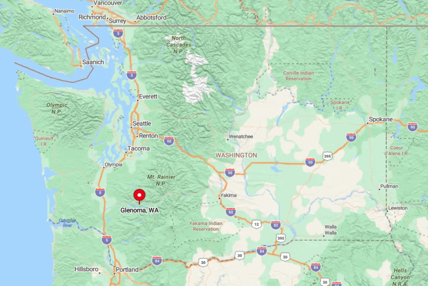
Located on U.S. Highway 12 in eastern Lewis County, Glenoma lies 60 miles east of Centralia and 25 miles west of White Pass. Riffe Lake hems in the southern edge while forested ridges rise abruptly to the north, forcing travelers to stay on the two-lane highway that doubles as Main Street.
Winter storms or summer wildfire closures can isolate the corridor for hours, underscoring the community’s detachment. Except for a once-a-week rural bus that stops 10 miles away in Morton, private cars remain the only dependable link to this lakeside settlement.


