Southwest Oklahoma is dotted with out-of-the-way communities where prairie grasses outnumber people and the night sky still belongs to the stars. Our roundup visits twenty five of these quiet places, each holding fewer residents than a city block yet offering scenery that stretches for miles.
In order to come up with the very specific design ideas, we create most designs with the assistance of state-of-the-art AI interior design software. Also, assume links that take you off the site are affiliate links such as links to Amazon. this means we may earn a commission if you buy something.
Travelers find rusty windmills, forgotten stretches of Route 66, and granite domes older than memory. Locals trade traffic for cattle guards and porch-light chats, proving that wide-open spaces remain alive and well on the southern plains.
From gold-rush ruins to wheat-field crossroads, these towns invite a slower pace and a camera with plenty of storage. Join us as we count down the most secluded corners of this often-overlooked region.
25. Cooperton — A Prairie Hamlet at the Refuge’s Edge
Cooperton, Oklahoma sits quietly in Kiowa County, one of the smallest incorporated towns in the state, where only a handful of homes cluster against the backdrop of wide prairie sky. Its seclusion comes from being nearly hidden along rural roads, with the Wichita Mountains rising in the distance like sentinels.
Once more bustling, Cooperton has slowly faded, leaving behind echoes of its early 20th-century life in weathered buildings and quiet streets. Visitors might drive through on their way to the Wichita Mountains Wildlife Refuge, pause to take in the silence, or wander the countryside where farmland meets open plains.
Life here is measured in seasons and the steady work of ranching, rather than the rush of modern schedules. Cooperton feels like a place where the land, not the clock, sets the rhythm of each day.
Where is Cooperton?
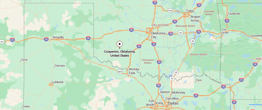
Cooperton, Oklahoma rests in the southwestern part of the state, tucked into Kiowa County near the Wichita Mountains. It’s about 25 miles north of Lawton, reached by leaving U.S. 62 and following smaller county roads that cut across open prairie.
The route carries you through flat farmland before the rugged outline of the mountains rises in the distance. By the time you arrive in Cooperton, the mix of wide plains and rocky hills makes it feel like a town quietly cradled between earth and sky.
24. Roosevelt — Granite Shadows on the Western Plains
Roosevelt, Oklahoma rests on the western edge of Kiowa County, a small town framed by open plains and the far-off rise of the Wichita Mountains. Its sense of seclusion comes from the wide stretches of farmland and prairie that surround it, leaving miles of quiet between neighboring towns.
Founded during the early 1900s land rush, Roosevelt still carries that pioneer spirit in its grid of streets and historic storefronts. A visitor might pass through the tiny downtown, stop at a local café, or drive toward the mountains for hiking and wildlife views.
Farming remains the backbone of daily life, with fields of wheat and cattle pastures marking the landscape. Roosevelt lingers as a reminder of how towns built on open land still hold steady against time’s push forward.
Where is Roosevelt?
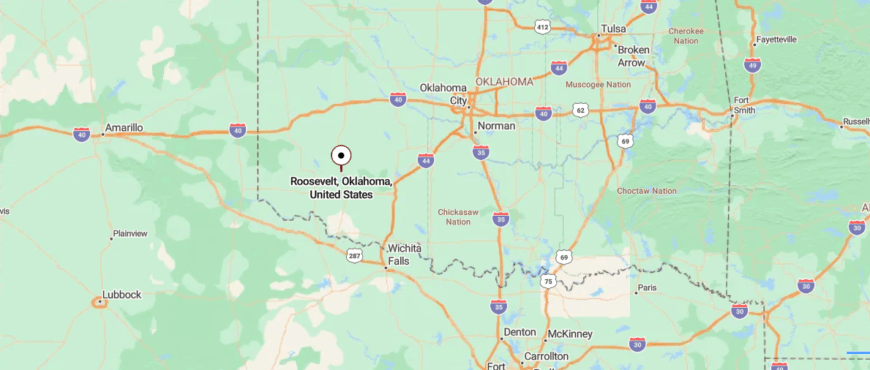
Roosevelt, Oklahoma sits in Kiowa County in the state’s southwest, just north of the Wichita Mountains. It’s about 30 miles west of Lawton, reached by taking U.S. 183 and then rolling along two-lane roads that cross farmland and open prairie.
The approach is wide and steady, with fields stretching toward the horizon and the faint outline of the mountains off to the south. By the time you reach Roosevelt, the spacious land and quiet pace give it a feeling of being both near the hills yet far from the noise.
23. Snyder — Gateway to the Wichitas

Snyder, Oklahoma lies in Kiowa County, a town shaped by both the prairie winds and the memory of history. Its seclusion comes from being surrounded by farmland and long, flat stretches of road that seem to run endlessly between fields.
The town is remembered for the devastating tornado of 1905, yet it rebuilt with grit, carrying that resilience into its quiet streets today. Visitors might walk through the small downtown, stop at local shops, or head toward nearby Lake Snyder for fishing and camping.
Life here is anchored in farming, schools, and community traditions that keep neighbors tied closely together. Snyder leaves you with the sense of a town that knows endurance, where the land and its people move forward hand in hand.
Where is Snyder?

Snyder, Oklahoma rests in Kiowa County, near the southwestern stretch of the state where the prairie meets the Wichita Mountains. It’s about 35 miles southwest of Lawton, reached by following U.S. 62 as it rolls past farmland and long, open plains.
The road in feels broad and unhurried, with distant views of rocky ridges rising from the flatland. When you arrive in Snyder, the vast sky and mountain edges make it feel like a place set apart on the edge of open country.
22. Gotebo — A Sleepy Crossroads of Cotton and Cattle

Gotebo, Oklahoma rests at the crossroads of prairie and sky in Kiowa County, a small town whose quiet is shaped by distance and wide horizons. Its seclusion comes from being surrounded by open farmland, where the nearest bustle lies miles down long, straight highways.
The town’s roots reach back to the railroad era, and though many businesses have faded, echoes of that past remain in its streets and buildings. A visitor might pause at the local museum, drive through farmland dotted with barns, or look toward the Wichita Mountains rising faintly in the distance.
Life here follows the rhythm of agriculture and community gatherings, where neighbors still recognize each other by name. Gotebo lingers as a place where history and stillness share the same wide stretch of land.
Where is Gotebo?

Gotebo, Oklahoma lies in Kiowa County in the state’s southwest, where farmland meets the quiet rise of the plains. It’s about 20 miles north of Hobart, reached by leaving U.S. 183 and following smaller state highways that cut through wide stretches of fields.
The approach is open and steady, with only silos and windmills breaking the horizon. By the time you reach Gotebo, the sweep of land and the stillness of the roads make it feel like a town tucked far from the rush of anywhere else.
21. Tipton — A Farming Village on the Red River Plains

Tipton, Oklahoma lies in Tillman County near the Red River, a town surrounded by fertile plains that stretch as far as the eye can see. Its seclusion comes from the miles of farmland that separate it from larger cities, giving it a quiet that feels anchored in the soil itself.
Known for its rich blackland earth, Tipton has long thrived on cotton, wheat, and cattle, with agriculture shaping both its economy and identity. A visitor might pass grain silos rising above the fields, watch tractors at work, or catch a Friday night game at the local school where the community gathers.
The pace is steady, guided by planting seasons and harvests rather than the rush of modern schedules. Tipton leaves you with the sense that the land is more than background here—it’s the very heart of life.
Where is Tipton?

Tipton, Oklahoma rests in Tillman County, close to the Red River that marks the Texas border. It’s about 30 miles southwest of Lawton, reached by following U.S. 62 before turning onto quieter stretches of State Route 5.
The drive passes through broad cotton fields and open prairie, with the horizon stretching wide in every direction. By the time you arrive in Tipton, the farmland and endless sky give it a feeling of calm distance from the bustle beyond.
20. Hollister — Grain Elevators on the Horizon

Hollister, Oklahoma sits quietly in Tillman County, a tiny community surrounded by sweeping farmland and open prairie. Its seclusion comes from being far off the main travel routes, where long stretches of road lead mostly to fields of wheat and cotton.
Once tied closely to the railroad, Hollister has grown smaller with time, leaving behind a scattering of homes, a post office, and memories of a busier past. A traveler might pause along its streets, catch the view of endless sky over silos, or drive onward to nearby Red River country.
Farming remains the lifeline here, with the land dictating the rhythm of work and rest. Hollister lingers as a place where silence and space are its strongest features, carrying the calm of a town left to its own pace.
Where is Hollister?

Hollister, Oklahoma sits in Tillman County, just a few miles north of the Red River near the Texas line. It’s about 10 miles south of Frederick, reached by leaving U.S. 183 and following a narrow two-lane road that slips through farmland.
The approach is marked by wide fields and open sky, with only the occasional farmhouse dotting the distance. By the time you arrive in Hollister, the quiet stretch of land makes it feel like a place set gently apart from the rest of the world.
19. Chattanooga — A Railroad Relic at the County Line

🔥 Would you like to save this?
Chattanooga, Oklahoma rests on the border of Comanche and Tillman Counties, a prairie town where the land stretches wide beneath an open sky. Its seclusion comes from being surrounded by endless farmland and long, quiet highways that seem to vanish into the horizon.
The town traces its roots to the early 1900s, built on the strength of farming and the railroad, both of which still leave their mark today. A visitor might pass grain elevators rising above the fields, wander its small grid of streets, or head toward the Wichita Mountains for a change in scenery.
Daily life leans on agriculture, with wheat, cotton, and cattle shaping the community’s rhythm. Chattanooga feels like a place where the prairie itself sets the tone—steady, open, and enduring.
Where is Chattanooga?

Chattanooga, Oklahoma rests in Comanche County, not far from the Wichita Mountains in the state’s southwest. It’s about 20 miles southwest of Lawton, reached by following State Highway 36 across rolling farmland and open prairie.
The drive is calm, with long views of fields broken by distant ridgelines and the occasional windmill. By the time you reach Chattanooga, the blend of wide plains and mountain edges gives it a quiet sense of being tucked away.
18. Davidson — A Borderland Community with Texas Ties

Davidson, Oklahoma rests in Tillman County just north of the Red River, a small town surrounded by wide farmland that stretches unbroken to the horizon. Its seclusion comes from the miles of quiet country roads that link it to neighboring towns, giving it a pace that feels steady and unhurried.
Founded with the arrival of the railroad, Davidson once bustled more than it does today, but its heart remains tied to agriculture. A visitor might see grain silos standing tall above cotton fields, stop at a local café, or simply watch the sunset turn the plains golden.
Life here is marked by the cycles of planting and harvest, with farming shaping both work and community ties. Davidson leaves the impression of a town that endures through the strength of its land and its people.
Where is Davidson?

Davidson, Oklahoma rests in Tillman County, near the southern edge of the state just a few miles from the Red River and the Texas border. It’s about 8 miles west of Frederick, reached by taking U.S. 70 as it runs straight across open farmland.
The approach is flat and expansive, with long stretches where fields and sky seem to meet without interruption. By the time you arrive in Davidson, the vast quiet of the plains makes the town feel small and set apart in its own wide world.
17. Headrick — A Forgotten Stop Near the Quartz Mountains

Headrick, Oklahoma rests in Jackson County, a tiny town that feels almost hidden along the backroads of the southwest plains. Its seclusion comes from the long stretches of farmland and open sky that surround it, leaving only a handful of streets and homes clustered together.
Once larger in the early 20th century, Headrick has quieted with time, its history still visible in weathered buildings and wide, empty lots. A traveler passing through might notice the grain bins, the quiet of the fields, or the faint outline of the Wichita Mountains in the distance.
Farming remains the steady thread here, with wheat and cattle defining much of daily life. Headrick lingers as a reminder of how small prairie towns hold on, even as the world rushes past them.
Where is Headrick?

Headrick, Oklahoma sits in Jackson County in the state’s southwest, tucked along the North Fork of the Red River. It’s about 12 miles east of Altus, reached by following U.S. 62 before turning onto a short country road that leads directly into town.
The drive passes cotton fields and stretches of prairie, with distant views of low ridges marking the horizon. By the time you arrive in Headrick, the quiet farmland and river valley make it feel like a place quietly tucked away from the wider world.
16. Martha — A Tiny Grain Hamlet

Martha, Oklahoma is a small Jackson County town set against the wide sweep of the southwest plains, where fields and sky seem to go on forever. Its seclusion comes from being tucked along quiet farm roads, far from the hum of larger cities.
The town’s history dates back to the early 1900s, once serving as a hub for farmers and railroad traffic, though today it carries only a fraction of that bustle. A visitor might see grain elevators rising above cotton fields, drive past weathered barns, or pause at the old school building that still tells of its past.
Life here leans on agriculture, with crops and cattle giving rhythm to the seasons. Martha feels like a place where history and open land weave together, holding steady in the quiet of the prairie.
Where is Martha?

Martha, Oklahoma rests in Jackson County, a small community set among the wide prairies of the state’s southwest. It’s about 8 miles northeast of Altus, reached by leaving U.S. 283 and following a short two-lane road that eases into town.
The approach rolls past farmland and open fields, with the sky stretching unbroken in every direction. By the time you arrive in Martha, the quiet land and endless horizon make it feel like a place gently set apart.
15. Eldorado — The End of the Highway

Eldorado, Oklahoma rests in Jackson County near the Red River, a town shaped by its wide farmland and the long horizons of the southwest plains. Its seclusion comes from being tucked at the edge of the state, far from major highways and surrounded by cotton fields and pastures that stretch for miles.
Founded during the early 1900s boom years, Eldorado once buzzed with railroad and farming trade, but today it moves at a gentler pace. A visitor might pass through its quiet main street, stop at a café, or head out to nearby country roads where the sky seems endless.
Farming remains the heartbeat here, with cotton and wheat defining both work and identity. Eldorado leaves you with the impression of a town that carries its history quietly, rooted firmly in the land around it.
Where is Eldorado?

Eldorado, Oklahoma lies in Jackson County near the Texas border, surrounded by the flat, open sweep of prairie. It’s about 28 miles southwest of Altus, reached by following State Highway 6 as it narrows into quieter country stretches.
The road in passes cotton fields, windmills, and long horizons with little to break the view. By the time you reach Eldorado, the stillness of the land and the wide sky make it feel like a town standing on the edge of solitude.
14. Blair — A Quiet Town Beneath Quartz Mountain

Blair, Oklahoma lies in Jackson County, nestled between the open prairies and the shadow of the nearby Quartz Mountains. Its seclusion comes from the broad stretches of farmland and the long drives that separate it from larger towns, giving it a calm, unhurried pace.
The town’s roots run back to the railroad and early agriculture, and those influences still shape its grain elevators, cotton fields, and small businesses. A traveler might stop in Blair on the way to the Quartz Mountains, wander its quiet streets, or watch the fields change with the seasons.
Daily life leans heavily on farming and ranching, with the land dictating much of the community’s rhythm. Blair lingers as a reminder of how Oklahoma’s small prairie towns hold steady under the vast sky.
Where is Blair?

Blair, Oklahoma sits in Jackson County in the state’s southwest, just north of the North Fork of the Red River. It’s about 10 miles north of Altus, reached by following U.S. 283 as it cuts through farmland and low, rolling prairie.
The approach offers long views of cotton fields and the faint outline of the Quartz Mountains to the northeast. By the time you arrive in Blair, the mix of open land and distant ridges gives it a quiet, tucked-away feel.
13. Granite — A Prison Town in the Hills

🔥 Would you like to save this?
Granite, Oklahoma rests at the foot of the rugged Wichita Mountains in Greer County, a town whose name comes from the red rock that surrounds it. Its seclusion comes from the way the mountains rise around it, giving the streets a sense of being cradled by stone and sky.
The town is known for its granite quarries, which have long shaped both its economy and its identity, with stone from here traveling far beyond the plains. Visitors can explore Quartz Mountain State Park nearby, hike the rocky trails, or visit the historic prison that still stands as part of Granite’s story.
Life here blends small-town rhythms with the presence of the mountains, where work, history, and nature intersect. Granite leaves you with the feeling of a place rooted in rock, steady and enduring against time.
Where is Granite?

Granite, Oklahoma rests in Greer County in the southwestern part of the state, set against the striking backdrop of the Quartz Mountains. It’s about 15 miles north of Altus, reached by taking U.S. 283 before turning onto State Highway 6, a road that runs straight through farmland into rugged hills.
The approach shifts quickly from flat fields to rocky outcrops, with the mountains rising suddenly against the prairie sky. By the time you reach Granite, the red stone cliffs and quiet streets make it feel like a town carved right out of the land itself.
12. Willow — A Remote Village of Wheat and Windmills

Willow, Oklahoma is a tiny community in Greer County, where the prairie stretches so wide it feels like the town is floating on open sky. Its seclusion comes from its size and remoteness, with just a few streets surrounded by miles of farmland and quiet country roads.
Once busier during the railroad era, Willow has settled into a slower pace, its history lingering in grain bins, barns, and weathered storefronts. A traveler might pass through on the way to nearby farmsteads, pause at the post office, or simply take in the endless horizon.
Farming and ranching remain the backbone of life, with wheat, cotton, and cattle shaping the seasons. Willow leaves the impression of a town that endures in stillness, carried forward by the land more than by change.
Where is Willow?

Willow, Oklahoma rests in Greer County, surrounded by the wide-open farmland of the state’s southwest. It’s about 20 miles northwest of Mangum, reached by following State Highway 34 and then narrowing county roads that stretch in long, straight lines across the prairie.
The drive is quiet and steady, broken only by silos and scattered farmhouses under the endless sky. By the time you arrive in Willow, the stillness of the plains makes it feel like a place far removed from the rush of anywhere else.
11. Carter — A Hidden Spot on the Beckham Plains

Carter, Oklahoma sits in Beckham County, a small prairie town where fields of wheat and cotton stretch far beyond its handful of streets. Its seclusion comes from the long highways and country roads that separate it from larger towns, leaving it quiet except for the sound of wind across the plains.
Founded in the early 1900s, Carter once thrived on the railroad and agriculture, and though the bustle has faded, its farming roots still run deep. A visitor might notice grain elevators rising above the flatland, stop at a local café, or drive into the countryside where sunsets spill wide across the horizon.
Daily life revolves around the soil, with planting and harvest setting the rhythm of the year. Carter leaves you with the feeling of a town defined not by size, but by the vast land it calls home.
Where is Carter?

Carter, Oklahoma sits in Beckham County in the state’s western plains, surrounded by farmland and long, open horizons. It’s about 15 miles southeast of Elk City, reached by leaving I-40 and following State Highway 34 as it narrows into quieter stretches.
The road carries you past flat fields, windmills, and clusters of cottonwood trees that break the skyline. When you arrive in Carter, the quiet land and broad sky make it feel like a town suspended in the wide openness of the plains.
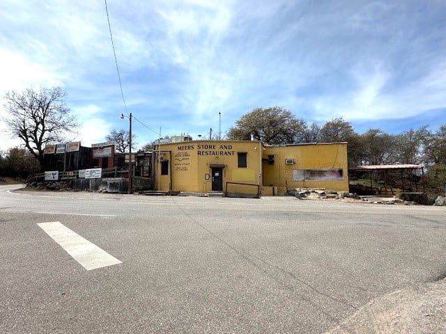
10. Meers — A Gold-Rush Hamlet in the Wichita Mountains

Fewer than 100 people call Meers home, yet the town’s famed burger café draws visitors from across the state. Guests explore 59,000 acres of nearby Wichita Mountains Wildlife Refuge, roving for bison herds, elk sightings, and quartz-lined hiking trails like Elk Mountain.
Ranching and small-scale tourism anchor the local economy, with souvenir-ready longhorn skulls and honey jars sold out of porch coolers. Weathered mine shafts and an abandoned stamp mill remind everyone that Meers began as a 1900s gold camp.
No chain stores, no stoplights, and only one paved road keep the settlement hushed after day-trippers leave. At sunset, the tin roofs glow copper against granite buttes, underscoring why photographers return every fall.
Where is Meers?

Meers hides inside Comanche County, deep within the Wichita Mountains about 20 miles northwest of Lawton. The town’s only access is Oklahoma State Highway 115, a twisting two-lane that threads through wildlife refuge gates and steep canyon walls.
Absence of through-traffic and the federally protected land on all sides prevent commercial growth, reinforcing the hamlet’s isolation. Visitors typically follow I-44 to Lawton, then drive 30 minutes of mountain curves before the famous yellow “Meers Store” sign appears.
9. Saddle Mountain — Kiowa County’s Hidden Foothill Village

Saddle Mountain supports roughly 40 year-round residents scattered across cedar-lined ranch tracts. Dawn finds locals photographing purple coneflowers and roadrunners along gravel section lines, while climbers scramble up the 500-foot granite knob that gave the town its name.
Cattle grazing and small hay operations supply most paychecks, with a weekend side hustle of drone photography workshops for visiting shutterbugs. The nearest convenience store sits 18 miles away, and cellular signals fade behind the ridges, creating a natural digital detox.
Star parties on cloudless nights reveal the Milky Way arcing over windmills, a sight city skies rarely allow. Here seclusion means neighbors are close enough to wave, yet distant enough for coyotes to outnumber porch lights.
Where is Saddle Mountain?

🔥 Would you like to save this?
The village rests on the Kiowa–Comanche county line, tucked south of State Highway 19 and ten miles of red-dirt roads. Surrounded by Bureau of Indian Affairs grazing leases and wildlife habitat, the area lacks any major corridor, shielding it from through-traffic.
Most arrive by exiting US-62 at Cooperton, then following county roads that narrow into caliche lanes. If a passing pickup raises dust ahead, travelers know they are almost there.
8. Loveland — A Whisper-Quiet Wheat Country Ghost Town

Loveland’s standing population hovers near a dozen, spread among widely spaced farmhouses built during the rail boom of 1908. Visitors wander past an empty main street of brick fronts, an abandoned grain elevator, and an intact depot that still boasts its original ticket window.
Dryland wheat and custom harvesting crews remain the sole industries, their seasonal rhythms echoed by prairie winds. Railroad tracks were removed in the 1940s, leaving Loveland at the terminus of a county blacktop with no reason for passers-through.
Nights bring total silence broken only by distant train horns along a different line, 15 miles away. The combination of big-sky vistas and ghost-town relics lends the settlement an uncanny stillness prized by landscape painters.
Where is Loveland?

Positioned in Tillman County, Loveland sits 22 miles west of Frederick and three miles from the Texas border fence. With no state highway frontage, the town relies on County Road EW183, a thin ribbon through endless wheat stubble.
Absence of services on that route keeps traffic negligible; some days the post van is the only visitor. Drivers reach Loveland by taking OK-5 west to a tiny sign, then following the tracks of grain trucks until the elevator silhouette appears against the horizon.
7. Vinson — Harmon County’s End-of-the-Road Outpost

A mere 20 residents inhabit Vinson, clustered around a shuttered school gym that now hosts holiday potlucks. Cotton and sorghum fields stretch in every direction, making fall harvest the town’s main event and economic lifeline.
Locals fish at nearby Lake Hall, pick sand-plums for jelly, and explore gypsum caves known only to area kids. Vinson’s seclusion stems from being 20 miles off the nearest paved highway, accessible only by red-dirt section lines that can flood after a storm.
Rusted storefronts and antique gas pumps recall a 1920s oil boomlet that never quite took hold. Today, dusk settles over empty crossroads, and visitors often comment they can hear their own heartbeat.
Where is Vinson?

The hamlet sits in western Harmon County, southwest of Hollis and a stone’s throw from the Texas Panhandle. Travelers leave US-62 at Gould, then jostle along county roads that lose cell coverage within minutes.
Surrounded by salt-flat prairie and playa lakes, Vinson endures minimal development because the land floods in wet years and bakes in dry ones. Those who brave the ruts find the old school’s orange-and-black Tigers mural greeting them at the first intersection.
6. Delhi — The Forgotten Crossroads of Beckham County

Delhi counts about 25 residents, most living on cattle spreads reached by cattle guards rather than street signs. Daylight hours see ranchers tending Angus herds or restoring classic tractors, while road-trippers photograph the 1910 stone schoolhouse still bearing carved chalkboards.
Beef, alfalfa, and small-scale hunting leases support the local economy, though many rely on Sayre for supplies. The town lost its rail line and post office decades ago, leaving two-lane roads and prairie gullies as the only companions.
With no commercial lighting, Delhi becomes a prime spot for meteor showers and barn-owl calls once darkness falls. It is the kind of isolation where porch swings remain the evening entertainment.
Where is Delhi?

Delhi occupies a lonely junction of State Highway 55 and County Road N1740, 15 miles south of Elk City. The settlement’s removal from I-40 traffic and lack of a convenience store within ten miles reduce casual visits.
To reach it, motorists exit the interstate, weave through wheat farms, and cross Sugar Creek’s low water bridge—impassable during floods. That periodic isolation cements Delhi’s quiet reputation.
5. Hext — Quiet Prairie Along Historic Route 66

Roughly 60 people reside among Hext’s scattered farmsteads, many of which still display faded Mother Road signage. Travelers walk the overgrown alignment of 1920s Route 66, spotting relics like the Johnson Oil Station’s concrete pylons and a rare Phillips “lighthouse” pump house.
Wheat and cattle provide income, supplemented by heritage tourism from die-hard roadies hunting photo ops. Interstate bypassing in the 1970s diverted traffic, sealing Hext in a time capsule of clapboard homes and wild sunflowers.
Nights echo only with coyotes and the distant roar of trucks on I-40, six miles north yet seemingly another universe. The combination of nostalgia and wide-open prairie defines its secluded charm.
Where is Hext?

Hext lies in Beckham County, four miles east of Sayre and just south of I-40’s Exit 25. Despite that proximity, no direct interchange connects to the old highway, forcing a loop of county roads that many travelers overlook.
The absence of services keeps the road empty except during the annual Route 66 vintage car rally. Pilgrims follow the original Portland-cement pavement—a narrow, cracking strip—to find the town.
4. Rainy Mountain — A Storied Valley of Granite and Grass

Rainy Mountain hosts about 30 inhabitants spread across ranches in a granite-rimmed basin steeped in Kiowa oral history. Visitors hike little-marked trails to petroglyph boulders, photograph morning fog rolling over buffalo grass, and explore remnants of the 1892 Rainy Mountain Mission.
Cattle ranching and seasonal hunting leases form the primary income, with occasional cultural tours led by tribal elders. Ringed by protected tribal lands and lacking a state highway, the valley stays hushed even during peak tourism months elsewhere.
Spring storms create waterfalls cascading down granite faces, a spectacle known mainly to locals. For most of the year, pronghorn and meadowlarks are the only traffic on the two-track roads.
Where is Rainy Mountain?

The valley lies ten miles west of Mountain View in Kiowa County, accessed by County Road E1360 that dead-ends at the mission ruins. Granite outcrops shield the basin from cell towers, adding another layer of retreat.
Drivers reach it by turning off OK-115 and following hand-painted signs past hay meadows and creek crossings. Once within the amphitheater, towering rock walls cut radio reception and modern noise alike.
3. Ahpeatone — Cedar-Rimmed Horse Country on the Red River

About 50 residents inhabit Ahpeatone, a clutch of horse farms and fishing ponds hidden behind ridges near the Texas state line. Daylight activities center on trail-riding, bow-fishing for gar along the Red River, and stargazing picnics at the decommissioned fire tower above town.
Quarter-horse breeding and custom saddle work keep money flowing, with ranch-to-table beef sold directly from coolers beside the road. Thick cedar breaks and lack of signage make the settlement nearly invisible from surrounding highways, preserving its quiet.
Nights reveal unbroken constellations mirrored in stock ponds, an astronomy club’s secret paradise. Visitors often comment that GPS drops pins a mile short, underscoring the locale’s tucked-away nature.
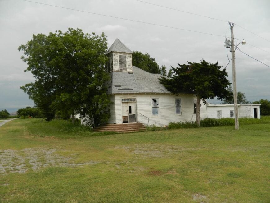
Where is Ahpeatone?

Situated in Cotton County, Ahpeatone sits five miles north of the Red River and twelve miles southeast of Walters. Reaching it requires leaving US-277, winding along gravel ridges, and descending into cedar-shaded hollows where cell service fades.
The community’s sole public marker is a small white church set back from the road, easily missed in summer foliage. Those who navigate the turns are rewarded with ranch gates bearing hand-forged brands and views stretching across state lines.
2. Corum — Cotton County’s Oak-Studded Upland

Corum registers just under 200 residents occupying oak-lined creek bottoms and hay meadows. Locals fish for bass beneath wooden bridges, hold pie suppers in the century-old community hall, and canoe slow-moving Beaver Creek.
Cattle, hay, and small apiaries provide livelihoods, while a volunteer art co-op sells prairie-themed canvases on weekends. The closest gas pump is eight miles away in Randlett, and winding county roads discourage casual traffic.
Morning fog often blankets lowlands, leaving only red barn roofs visible—a dream setting for photographers. The result is a community that feels private without being unfriendly.
Where is Corum?

Corum rests between State Highways 65 and 70 in north-central Cotton County, yet no direct highway passes through town. Visitors exit SH-65 onto gravel CR 1840, then follow it three miles into rolling oak savanna.
Landscape-blocking tree lines and meandering creeks keep road expansions at bay, sustaining Corum’s secluded status. Anyone arriving after dark should watch for white-tailed deer leaping across the lane just before the first farmhouse mailbox.
1. Alden — Sugar Creek’s Secluded Bend

Only about 15 people reside in Alden, their homes set among 1,000 acres of wheat fields, wild plum thickets, and cottonwood stands along Sugar Creek. Residents enjoy kayaking quiet bends of the creek, hunting turkey in spring, and trading canned sand-plum jelly at the one-room community center.
Dryland farming of wheat and milo forms the economic backbone, with a few families leasing pasture to neighboring cattle operations. The town’s sole paved spur ends abruptly at a low-water crossing, cutting it off during heavy rains and guaranteeing uninterrupted horizons the rest of the year.
Without streetlights, the Milky Way casts faint shadows on grain silos, creating perfect astrophotography conditions. Even postal deliveries occur just three times a week, preserving Alden’s hush.
Where is Alden?

Alden lies 15 miles northwest of Anadarko in Caddo County, reachable only via County Road N2590, a dead-end path paralleling Sugar Creek. Thick gallery forests and the winding waterway hem in the settlement, discouraging future road improvements.
Travelers leave US-62 at the unmarked gravel turnoff and navigate cattle guards before the landscape opens to wheat fields. The final clue that they have arrived is a weather-worn sign reading “Alden Community Building—Est. 1902.”