Would you like to save this?
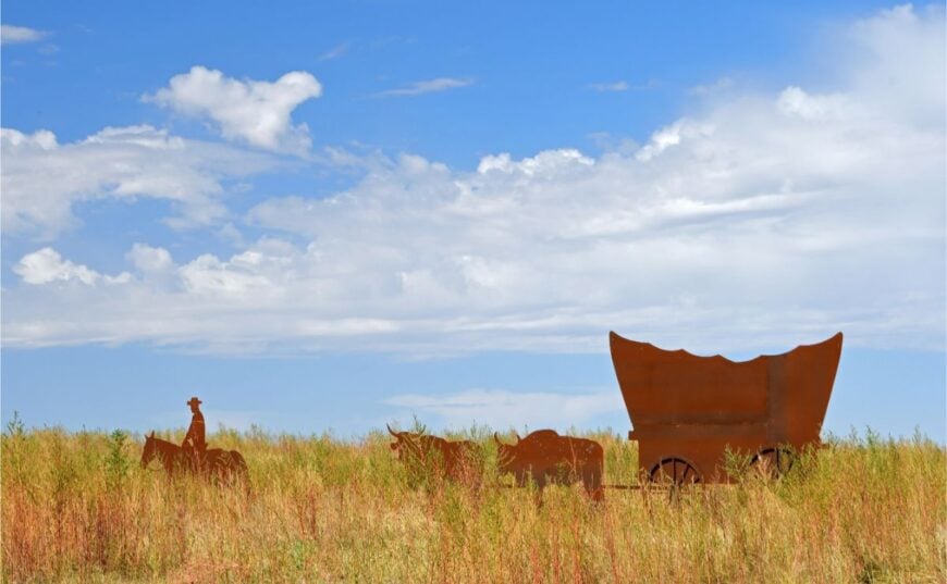
Southwest Kansas rarely grabs headlines, yet its back-road communities are perfect for anyone who wants elbow room, big skies, and a slower rhythm. The towns below sit far from interstates and shopping centers, surrounded by rangeland, wheat fields, and weather-sculpted bluffs that keep crowds away.
Each has a story that involves railroads, ranching, or the Santa Fe Trail, but today they trade bustle for tranquility. We selected spots where night is still genuinely dark, traffic lights are nonexistent, and neighbors wave because they actually recognize one another.
Visitors can photograph century-old storefronts, listen to meadowlarks without highway hum, and discover that quiet is easier to find than Wi-Fi. Our countdown starts in Manter, the windmill town, and ends at the edge of the Cimarron National Grassland.
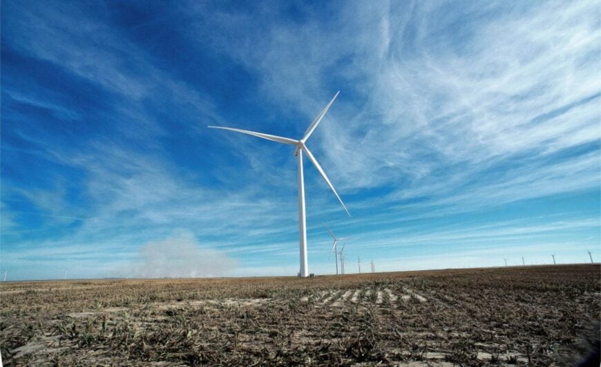
25. Manter – Windmill Town on the Open Divide
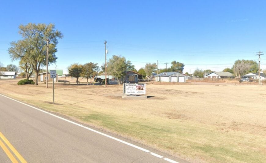
Manter sits low and steady on the prairie, where windmills turn and the sky seems to start at your doorstep. It feels secluded because section-line roads stretch to the horizon in every direction, and most travelers stay on the distant highways.
The rhythm is farm-first: pickups with seed sacks, coffee cups on dashboards, and neighbors who wave long before you’re close. Walk the quiet grid for elevator photos, watch meadowlarks riding the fence lines, or catch a blood-orange sunset that looks big enough to touch.
Spring brings prairie-chicken booming on nearby ranch leks; fall is for dust trails and long shadows. Work follows wheat, sorghum, and cattle, with school games as the week’s social anchor. It’s the kind of place where the wind sings backup to everyday life.
Where is Manter?
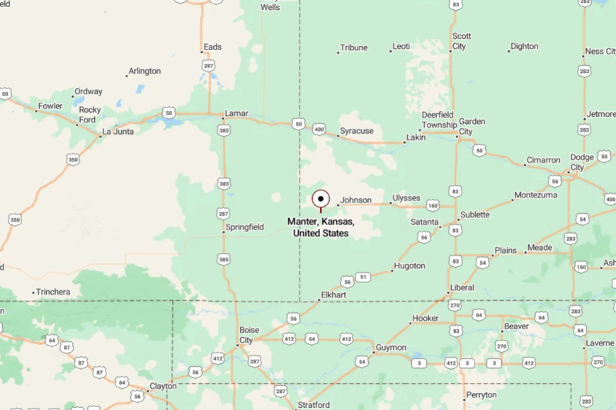
Tucked in far southwest Kansas, Manter lies in Stanton County on a lonely stretch of two-lane highway between Johnson City and the Oklahoma line. You reach it via K-27, then slow onto town streets that meet the prairie without fences.
With no interstates nearby, the landscape keeps its voice. It’s close enough for a day drive, yet far enough to reset your heartbeat.
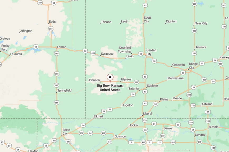
24. Big Bow – A One-Store Crossroads with Endless Sky
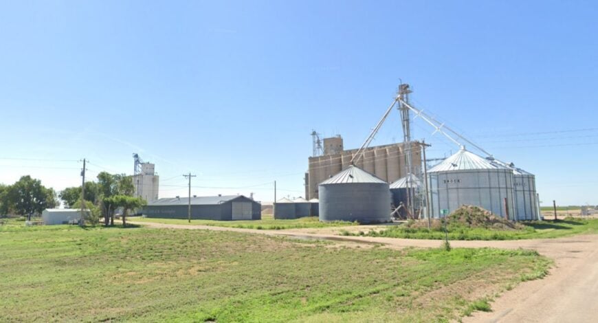
Big Bow is scarcely more than a name on the map, a tiny clutch of homes where wheat fields press right up to the mailbox posts. Seclusion comes easy here—no stoplights, no storefront rows, and miles of gravel spurs that slide into open range.
The vibe is spare and peaceful: wind through cedars, gate chains clinking, a dog asleep on the porch slab. Bring a camera for old granaries and wide-sky panoramas, glass the draws for pronghorn, or follow a dusty lane at golden hour just to see the light change.
Weekend hobbies lean simple—garden rows, fence repairs, thermoses of sweet tea. Farming and ranch work keep the days full without ever getting loud. Big Bow is proof that quiet can be a destination.
Where is Big Bow?
Kitchen Style?
You’ll find Big Bow in southern Stanton County, not far from the Colorado line and a few easy turns off US-160. Getting there means leaving the highway for straight-as-a-string county roads that trade speed for calm.
The last mile is usually just you, the sky, and a ribbon of dust. It feels like a private slice of prairie once you arrive.
23. Johnson City – County-Seat Calm on the High Plains
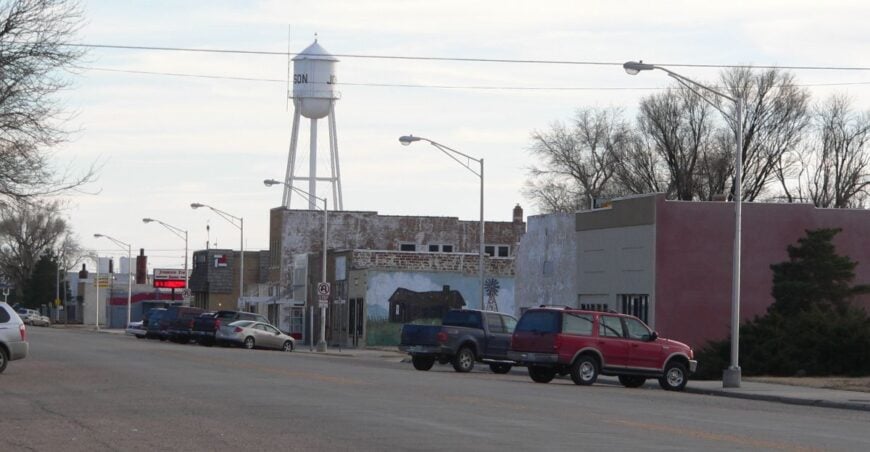
Johnson City keeps its pace measured and friendly, a tidy grid with courthouse shade trees and porches that catch the evening breeze. Seclusion lingers despite the county offices, thanks to long distances between towns and the absence of big-box bustle.
The feel is solid and neighborly: bake sales, small murals, and an elevator skyline at daybreak. Browse the local museum, follow section roads to seasonal wildflower patches, or bike the quiet streets at sunset.
Birders work shelterbelts after summer storms, and stargazers claim alleys when the wind lies down. Agriculture and public services share the workload here, each tuned to the weather. It’s a town that makes room for both errands and silence.
Where is Johnson City?
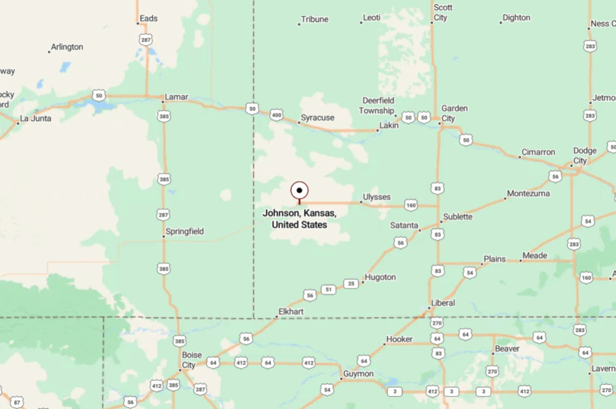
Johnson City sits in Stanton County near the western edge of Kansas, where US-160 meets K-27. Approaches roll through uninterrupted farm country that keeps traffic light and horizons long.
You’ll slow naturally as the courthouse comes into view. It’s easy to reach—and easier to forget the clock.
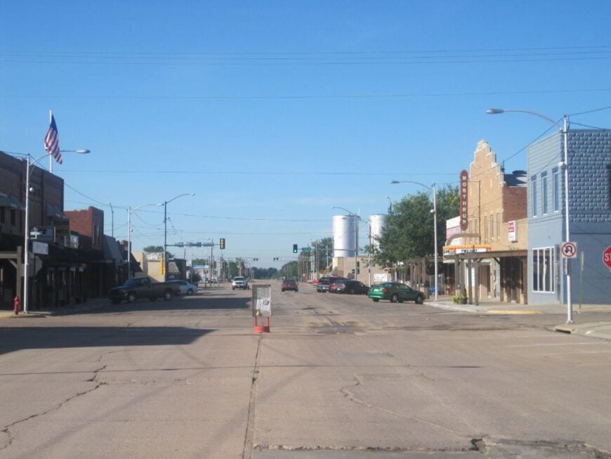
22. Syracuse – River-Valley Stop with Old Rail Bones
Home Stratosphere Guide
Your Personality Already Knows
How Your Home Should Feel
113 pages of room-by-room design guidance built around your actual brain, your actual habits, and the way you actually live.
You might be an ISFJ or INFP designer…
You design through feeling — your spaces are personal, comforting, and full of meaning. The guide covers your exact color palettes, room layouts, and the one mistake your type always makes.
The full guide maps all 16 types to specific rooms, palettes & furniture picks ↓
You might be an ISTJ or INTJ designer…
You crave order, function, and visual calm. The guide shows you how to create spaces that feel both serene and intentional — without ending up sterile.
The full guide maps all 16 types to specific rooms, palettes & furniture picks ↓
You might be an ENFP or ESTP designer…
You design by instinct and energy. Your home should feel alive. The guide shows you how to channel that into rooms that feel curated, not chaotic.
The full guide maps all 16 types to specific rooms, palettes & furniture picks ↓
You might be an ENTJ or ESTJ designer…
You value quality, structure, and things done right. The guide gives you the framework to build rooms that feel polished without overthinking every detail.
The full guide maps all 16 types to specific rooms, palettes & furniture picks ↓
Syracuse gathers along the Arkansas River valley, a small center where grain cars, cottonwoods, and redbrick storefronts share the same frame. Though it’s a county seat, it still feels tucked away because most travelers are pushing on toward state lines and leave the side streets untouched.
The vibe is warm and workmanlike: café chatter, hardware stores with everything, and summer nights that smell like cut alfalfa. Walk the river levee at dawn, explore mural alleys, cast a line in shaded eddies, or drive backroads to catch lightning storms rolling in from the west.
Rail history lingers in spurs and depots, quiet as old stories. Farming anchors daily life, with harvest season adding a low, steady hum. Syracuse reminds you that usefulness can be beautiful.
Where is Syracuse?
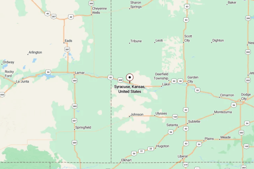
In Hamilton County near the Colorado border, Syracuse rests along US-50 on the Arkansas River’s broad plain. You slip off the highway, and the town appears under tall trees and elevator silhouettes. Distance from interstates preserves the night and the hush. It’s a valley town that still feels like a hideaway.
21. Deerfield – Small Town, Big Horizon
Deerfield looks west across fields that change color with the seasons—emerald circles in spring, blond quilt squares by July. Its seclusion owes to long gaps between neighbors and the way the river valley swallows highway noise.
The vibe is friendly and straightforward: a café that tops off your cup twice, tidy parks, and evening walks under cicada buzz. Fish a quiet bend of the Arkansas, photograph antique signs on brick, or follow gravel lanes to see storm cells bloom.
Harvest fills the streets with grain trucks for a spell, then they go still again. Farming is the metronome; everything else keeps time. Deerfield is small enough to hear the wind shift.
Where is Deerfield?
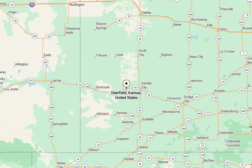
You’ll find Deerfield in Kearny County, west of Garden City on the broad, open run of US-50/400. The approach is simple and flat, with long views that take their time shrinking.
Slip into town and the pace drops a notch. It’s close to the river, far from the rush.
20. Lakin – Courthouse Town on the Old Trail
Lakin spreads its shade trees and sidewalks along the river corridor, a polite prairie town with an easy handshake. It feels secluded, not for lack of roads, but for the distance to any true bustle and the way evenings belong to sprinklers and porch talk.
The tone is neighborly and proud: a little museum, a few cafes, lawns that green up after a good rain. Walk the park loop, hunt antique nooks, cast for catfish at dawn, or drive dirt spurs to watch a thunderhead tower over the flats.
Harvest weeks bring a gentle clatter to Main Street, then quiet returns. Agriculture and county work keep things steady. Lakin is a good place to remember names and constellations.
Where is Lakin?
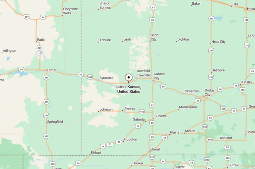
Set in Kearny County, Lakin sits along US-50/400 between Garden City and Syracuse. Getting there is a straight shot through farm country and big sky.
The river corridor and open acres keep the soundscape soft. It’s a “right off the road” stop that somehow feels miles away.
19. Pierceville – Trackside Hamlet with a Whispered Past
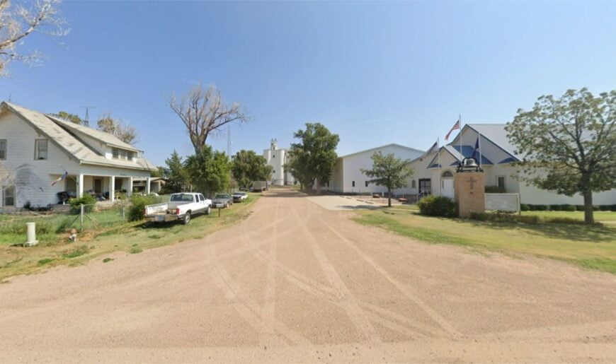
Pierceville is a tiny trackside settlement where grain bins gleam and the main street could host a game of catch. Seclusion holds because the town sits between bigger neighbors, leaving only locals and wanderers to stop.
The vibe is gentle and faintly nostalgic: porch gliders, crickets, and freight trains sliding by like long memories. Photograph weathered storefronts, watch swallows loop under the elevators, or wander out for sunset portraits against a clean horizon.
After dark, the Milky Way is bright enough to navigate by. Farming frames the day; the rails mark the night. Pierceville is a pause you can feel.
Where is Pierceville?
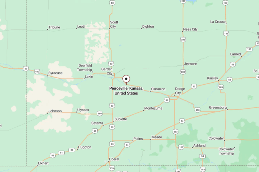
You’ll find it in Finney County, southeast of Garden City on the old US-50/400 line. The highway thins to two lanes, and the traffic thins right with it.
A short turn deposits you in a small town wrapped in fields. It’s the kind of place you could miss—and be glad you didn’t.
18. Ingalls – Little Town with a Big Western Sky
Ingalls keeps itself tidy and calm, a handful of blocks with an outsized view of weather and light. Seclusion comes from distance and openness; with few trees, the horizon gets all the attention.
The vibe is practical and friendly—coffee at the co-op, kids biking to the park, flags lifted by a steady breeze. Visit the local historic house museum, catch a school ballgame, or drive out at dusk to watch combine lights drift like fireflies.
On summer mornings, doves and train horns are the only sounds. Agriculture holds the center, as it has for generations. Ingalls teaches you to watch the sky.
Where is Ingalls?
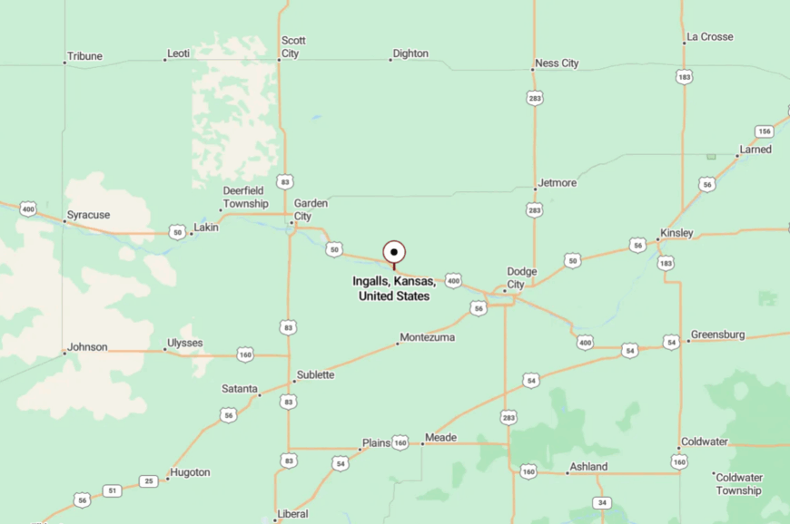
In Gray County west of Dodge City, Ingalls rests along the broad run of the old Santa Fe route. US-50 brings you close; a short turn carries you into quiet streets.
With big towns distant, the silence arrives quickly. It’s easy to find and easier to hear yourself think.
17. Ensign – A Grain-Country Corner with Porch-Light Evenings
Ensign sits where prairie meets sky, a trim little place with streets that glow soft after sundown. Its seclusion stems from miles of cropland in every direction and the simple fact that there’s no reason to hurry through.
The vibe is homey: dogs under pickups, garden hoses ticking in lawns, and neighbors swapping zucchini on tailgates. Walk to the tiny park, roll a bicycle down to the elevator for a photo, or drift out on gravel to watch hawks kite on the breeze.
Weekend drives lead to quiet reservoirs and ghostly former depots. Farming and seed cleaning set the rhythm; everything else fits between rains. Ensign makes the small look rich.
Where is Ensign?
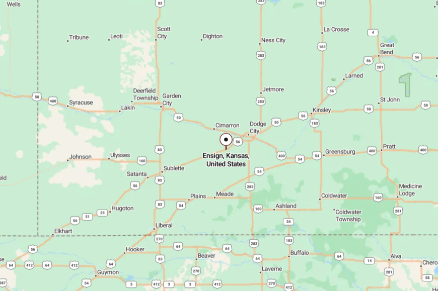
You’ll find Ensign in eastern Gray County on an easy two-lane highway between Cimarron and Montezuma. The last miles cut through open fields where the horizon steals attention.
Step off the highway and the noise falls away. It’s a small turn into a slower world.
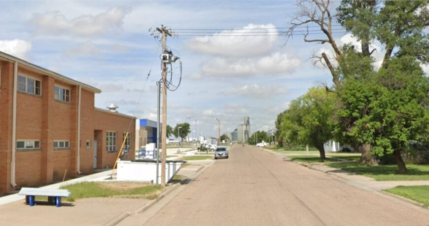
16. Montezuma – Wind-Farm Silhouettes over Wheat
Would you like to save this?
Montezuma feels quietly confident, a prairie town that pairs church bells with wind turbines on the rim of sight. Seclusion lingers because big cities are far, and the nearest four-lane doesn’t change the town’s daily habits.
The vibe mixes old and new: a café famous for pies, tidy storefronts, and the soft whoosh of blades on still mornings. Browse the local museum, day-trip to the grassland for birds and wildflowers, or photograph elevators backed by a quilt of milo and corn.
Evenings taste like dust and lilac after a storm. Agriculture is the backbone, with renewable energy a modern companion. Montezuma gives the plains a gentle, forward look.
Where is Montezuma?
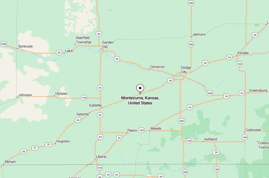
In Gray County, southwest of Dodge City, Montezuma sits along an easy corridor of two lanes that trade speed for scenery. You roll through shelterbelts and wide-open acres before town rises with its elevator crown.
With interstates distant, the night stays dark. It’s close enough for pie, far enough for stars.
15. Sublette – Crossroads Town with Prairie Edges
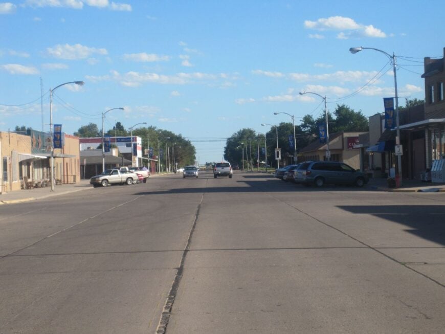
Sublette is a classic crossroads, the kind of place where grain trucks, school buses, and pickups choreograph the day without crowding a soul. Its seclusion is more about distance than direction; the roads are good, the neighbors are far.
The feel is steadfast and welcoming: a main street with purpose, a library that knows your name, and Saturday ballgames after chores. Tour small historical exhibits, sip coffee where everyone nods hello, detour to windbreaks for songbirds, or drive south into the open grass for antelope silhouettes.
Harvest and cattle feeding share top billing, and weather gets a seat at every table. Nights are quiet enough to hear sprinklers across town. Sublette wears the plains well.
Where is Sublette?
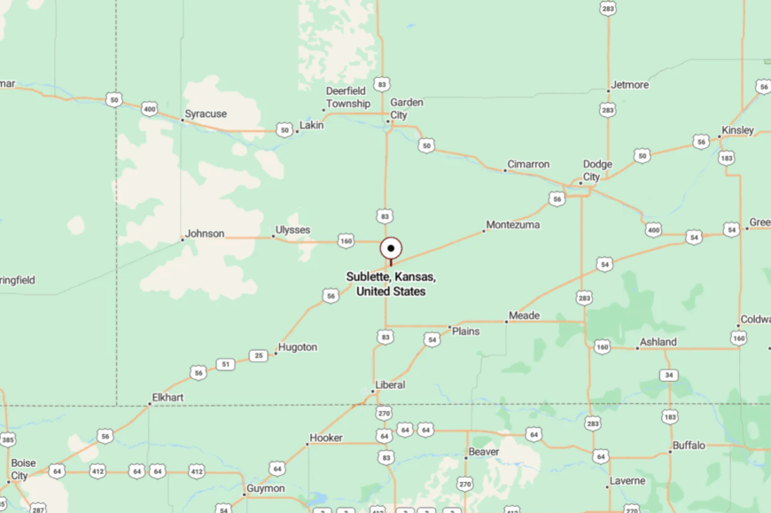
Centered in Haskell County, Sublette meets you at a simple prairie junction with long views on every side. The approaches are straight shots across farmland; you’ll spot the elevator before the street signs.
With no urban glow nearby, the stars show up early. It’s a crossroads that still feels like an end of the road.
14. Satanta – Prairie Bands and Saturday Parades
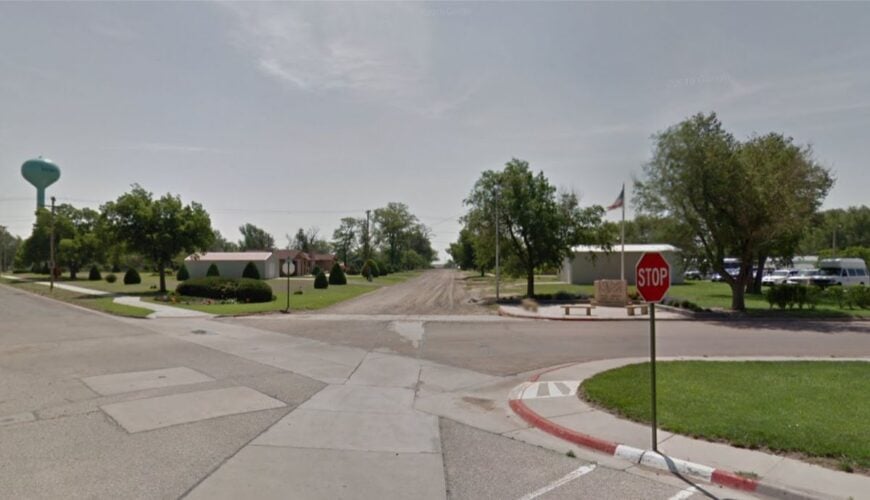
Satanta keeps a friendly bustle—school bands practicing on the breeze, storefront flags lifting in afternoon wind, neighbors catching up outside the market. Seclusion persists because the town sits amid big farms and long distances, with traffic thinning as fields widen.
The vibe is proud and homegrown: community festivals, classic pickups, and murals that nod to Kiowa heritage. Stroll Main Street for thrift finds, cycle quiet roads to windbreak groves, birdwatch on nearby creek draws, or follow two-lanes toward the grassland for wide-open views.
Weeknights end with the hush of irrigation pivots and crickets. Farming and school life share the calendar. Satanta is lively enough to feel known and small enough to feel kept.
Where is Satanta?
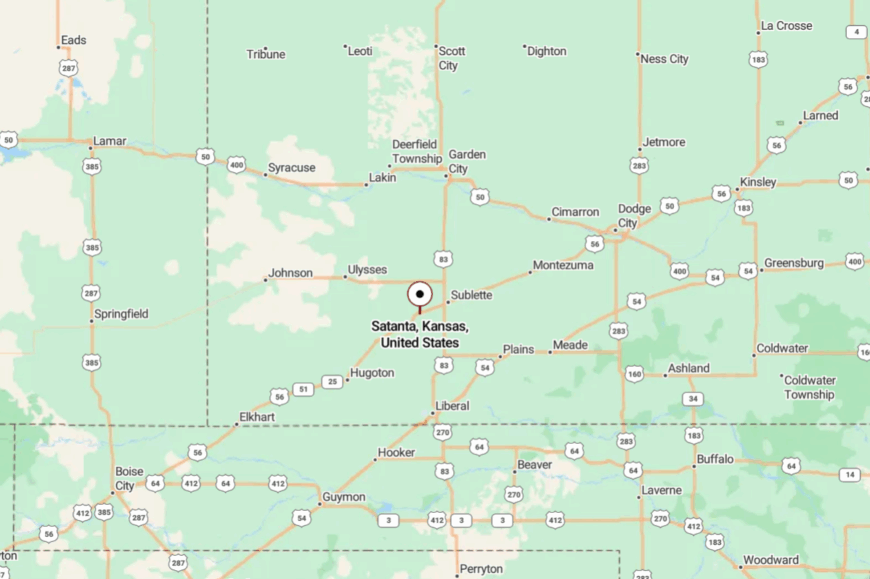
In Haskell County between Sublette and Hugoton, Satanta sits along a calm run of two-lane prairie highway. You’ll drive past wheat and milo fields before the elevator and water tower rise from the horizon.
The distance to bigger towns keeps evenings still. It’s the midpoint that feels like a retreat.
13. Plains – A Straight-Shot Town with the Widest Main
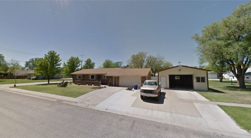
Plains spreads confidently on level ground where trains once set the tempo and sunsets still steal the show. It feels secluded because the prairie runs on all sides, and the nearest city glow is a long, flat drive away.
The mood is neighborly and no-nonsense: broad streets, tidy porches, and kids cruising bikes after supper. Hunt vintage signage for photos, cast for catfish at nearby ponds, browse a tiny antique nook, or take a back-road loop to watch deer step from shelterbelts.
Harvest season adds a warm rumble, then quiet returns as sprinklers tick. Farming keeps the ledger; community keeps the anchor. Plains turns open space into a welcome.
Where is Plains?
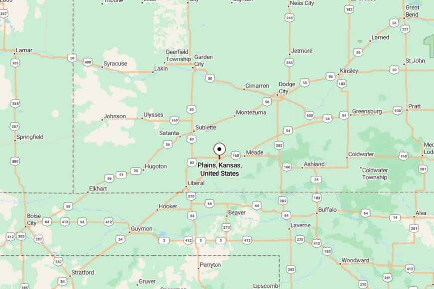
You’ll find Plains in Meade County on the far southwestern tablelands, west of Meade and east of Liberal. The approach is straight and simple on a two-lane ribbon that favors long thoughts.
With cities far off, the nights go truly dark. It’s as easy to reach as it is to exhale.
12. Fowler – Porch Swings and Elevator Echoes
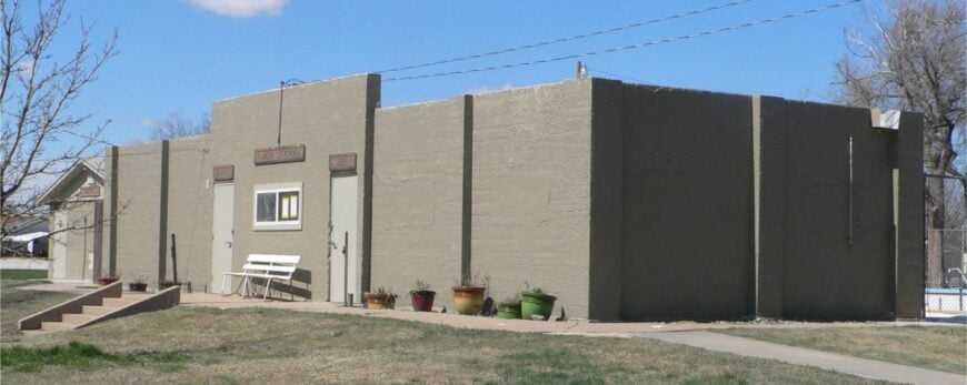
Fowler holds steady on the prairie, a small town where porch swings move with the wind and trains are more rumor than interruption. Seclusion sticks because bigger places are a long drive away, and most visitors are heading somewhere else.
The vibe is soft-spoken: a café where everyone greets you, a park with earnest shade trees, and an elevator that gleams at sundown. Walk the quiet grid for photo-worthy brickwork, look for kestrels along the fencerows, drive out to watch storms bloom, or bring a lawn chair for easy stargazing.
Harvest comes and goes; evenings belong to crickets. Farm life pays the bills and shapes the stories. Fowler makes time feel handmade.
Where is Fowler?
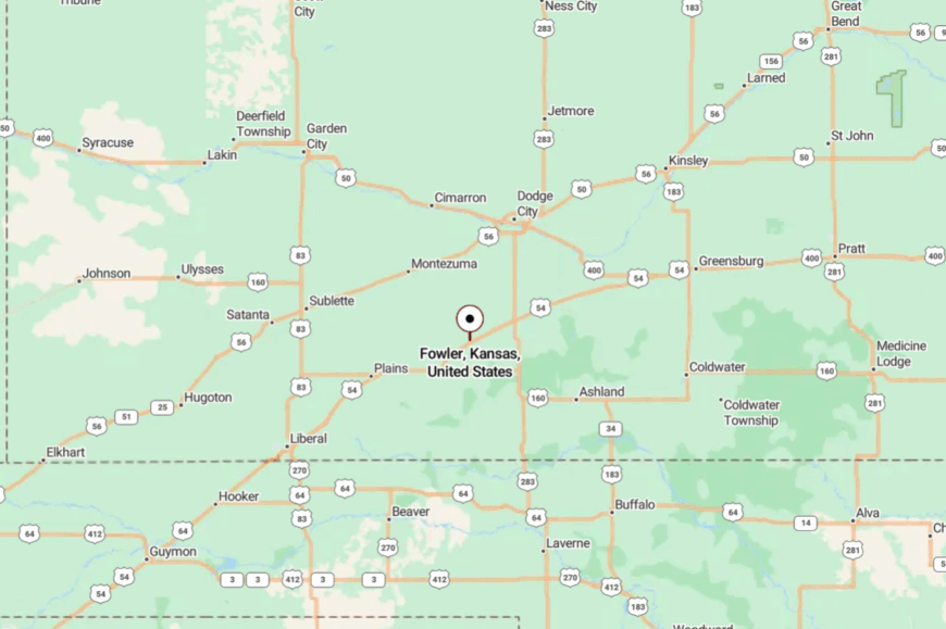
In Meade County on the open plains west of Dodge City, Fowler sits a few calm turns off the main travel corridors. Two-lane approaches cross fields so broad they feel like an ocean.
The distance keeps the town hushed after dusk. It’s reachable in an hour—and memorable for much longer.
11. Ashland – Red Hills Town with Canyon Light
Ashland leans against the Red Hills, where gypsum cliffs glow and cottonwoods rattle in a dry wind. Seclusion is written into the country itself—broken mesas, long ranch lanes, and little to tempt hurry.
The vibe is ranch-tough and hospitable: a main street with good pie, a feed store with opinions, and stories that begin with weather. Hike canyon rims at daybreak, fish quiet coves at the state lake, scan draws for mule deer, or follow sandy two-tracks to find yucca blooming under thunderheads.
Branding season perfumes the air with smoke and coffee; after dark, stars run right to the ridgelines. Ranching leads the ledger; everything else makes room. Ashland leaves red dust on your boots and calm in your chest.
Where is Ashland?
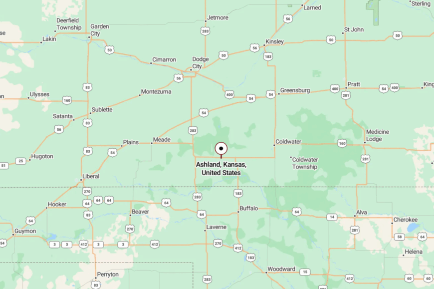
Deep in Clark County near the Oklahoma line, Ashland sits where prairie lifts into the Red Hills. You reach it on two-lanes that bend through canyons and pastures, a route that slows you whether you like it or not.
With interstates distant and bluffs close, the quiet feels natural. It’s close enough for a day trip, far enough to feel like you’ve left everything behind.
10. Richfield – Prairie Hamlet Lost in Morton County’s Rolling Grasslands
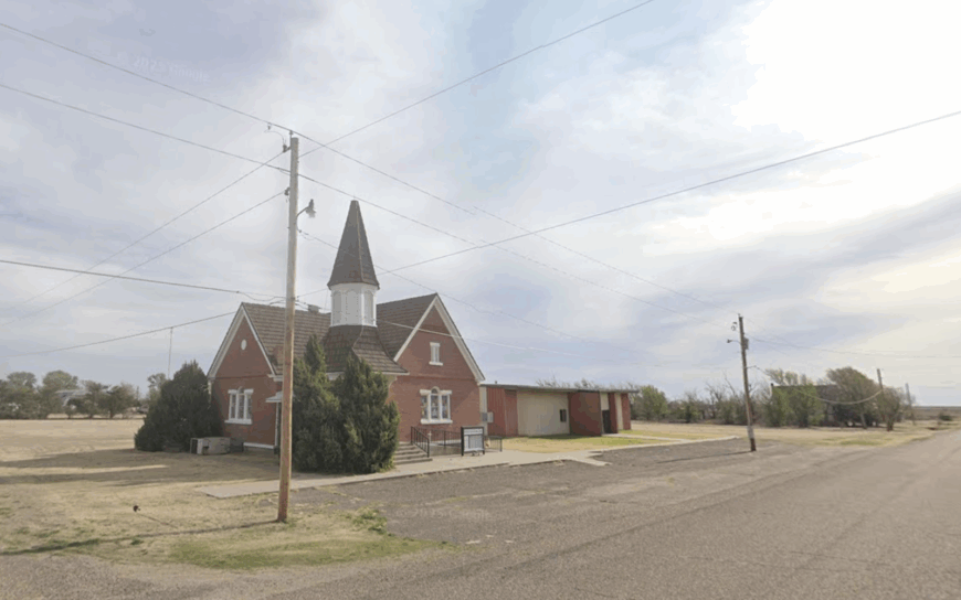
Richfield’s population hovers around 40, making it one of Kansas’s emptiest incorporated towns. Travelers can roam the nearly vacant grid, peek inside the 1920s stone jail, or hike the nearby St. Jacobs Well Trail, where antelopes outnumber people.
Agriculture and limited ranch support services are the primary sources of income, though many residents commute twenty miles to Elkhart for work. A sense of seclusion comes from treeless grasslands and wind-carved dunes that stretch to every horizon.
The nearest grocery store is twenty miles away, and cell service flickers in and out, adding to the remote feel. Even freight traffic is scarce, so evenings echo only with coyotes and prairie wind.
Where is Richfield?
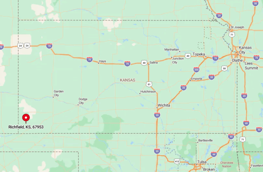
Richfield sits in north-central Morton County, three miles off Kansas Highway 27 and just twelve miles from the Colorado line. Endless ranchland on all sides limits development and buffers the town from through traffic.
Reaching it requires a deliberate detour on lightly traveled county roads that can become rutted after summer storms. The reward is pure solitude beneath an unbroken sky.
9. Coolidge – Santa Fe Trail Outpost on the Colorado Line
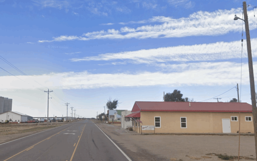
Coolidge counts roughly 80 residents clustered along broad dirt streets that once served wagon caravans on the Santa Fe Trail. Photographers come for the lonely grain elevator, the weather-beaten depot, and original trail ruts that slice the surrounding prairie.
Farming and elevator operations remain the dominant livelihood, with a seasonal bump from heritage tourism tied to the trail. Coolidge feels secluded because it is the last Kansas stop before Colorado, flanked by open rangeland and lacking any chain businesses.
Nights are silent except for occasional Burlington Northern trains sliding past the depot. The absence of streetlights grants Milky Way views that rival mountain towns.
Where is Coolidge?
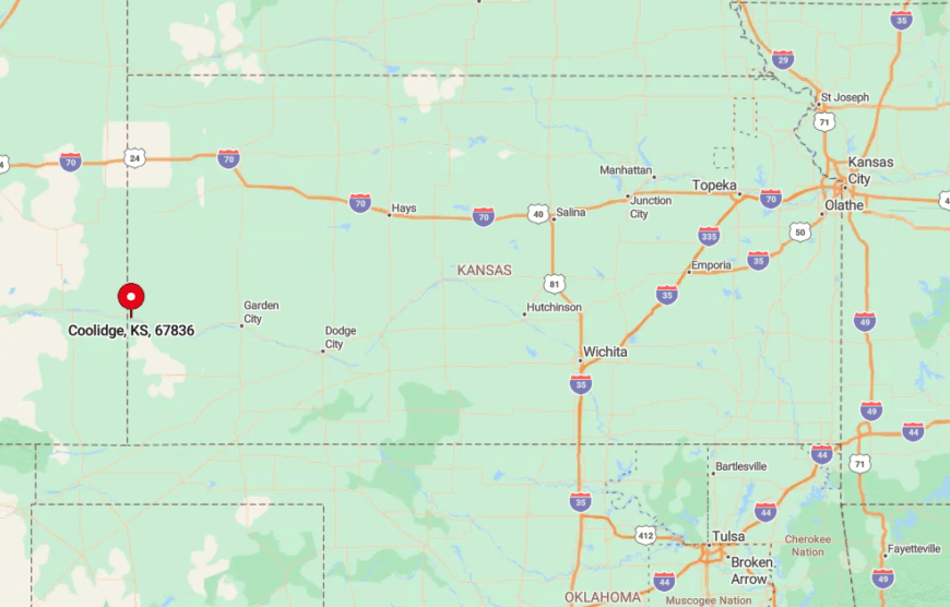
Located on US 50 at the western edge of Hamilton County, Coolidge is 17 miles west of Syracuse and 240 miles from the nearest metro city, Pueblo. It is hemmed in by prairie that remains largely unplowed, and the Arkansas River’s shallow channel forms a natural buffer to the south.
Most visitors arrive by car along US 50, though cyclists on the TransAmerica Trail also pass through. Because services are minimal, anyone heading there usually packs snacks and extra fuel.
8. Englewood – Red Hills Refuge Tucked Behind Scarlet Buttes
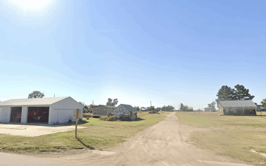
Englewood, home to about 70 people, nestles against the Red Hills where gypsum cliffs glow crimson at sunset. Locals explore gypsum caves, fish at nearby Englewood Lake, and stargaze from bluff-top overlooks that double as informal campgrounds.
Ranching and limited oilfield support anchor the economy, while a volunteer fire crew and tiny cafe keep civic life alive. Scarlet buttes shield the town from highways, and the closest Walmart sits an hour away in Dodge City, intensifying its hidden nature.
Empty storefronts along Main Street serve as reminders of a busier era, but now create a ghost-town hush. Coyotes often trot across the asphalt without slowing down.
Where is Englewood?
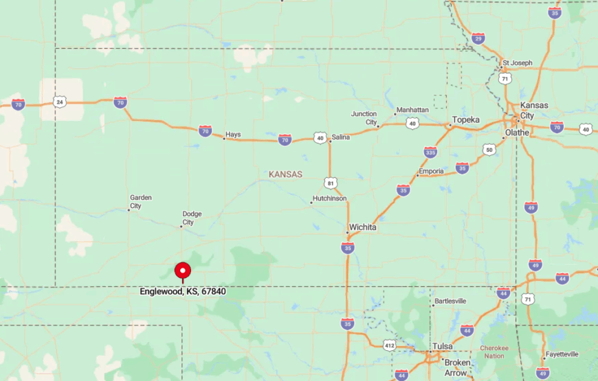
Englewood lies in southeastern Clark County, ten miles north of the Oklahoma border and a hearty thirty-five miles off US 283. Rugged canyons isolate it, and low water crossings can become impassable after heavy rain.
Drivers usually reach Englewood via county gravel routes that weave through ranch gates and oil pump jacks. The payoff is unrivaled night skies and quiet picnic spots atop gypsum plateaus.
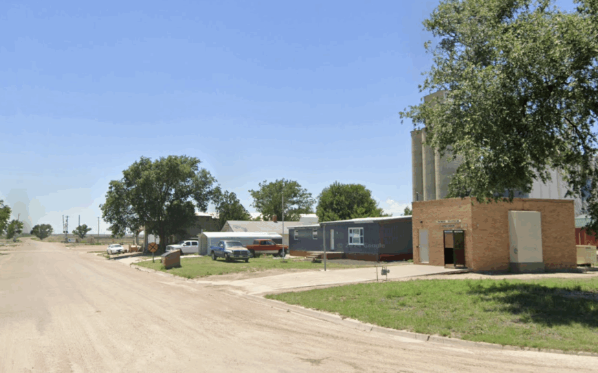
7. Kendall – One-Storefront Settlement on a Lazy Arkansas River Bend
Would you like to save this?
Kendall hosts roughly 65 residents scattered along a cottonwood-lined bend of the Arkansas River. Visitors like to cast for channel catfish, photograph the lone red-brick post office, and picnic at hidden sandbars south of town.
Dryland farming and cattle operations provide modest income, with postal work being the only official main-street job. Seclusion stems from its placement five miles off K-25 and the natural river barrier that discourages drive-through traffic.
Dirt roads wander into wheat fields, and GPS signals can vanish without warning. Even on July evenings, the loudest sound is usually crickets pulsing from the riparian grass.
Where is Kendall?
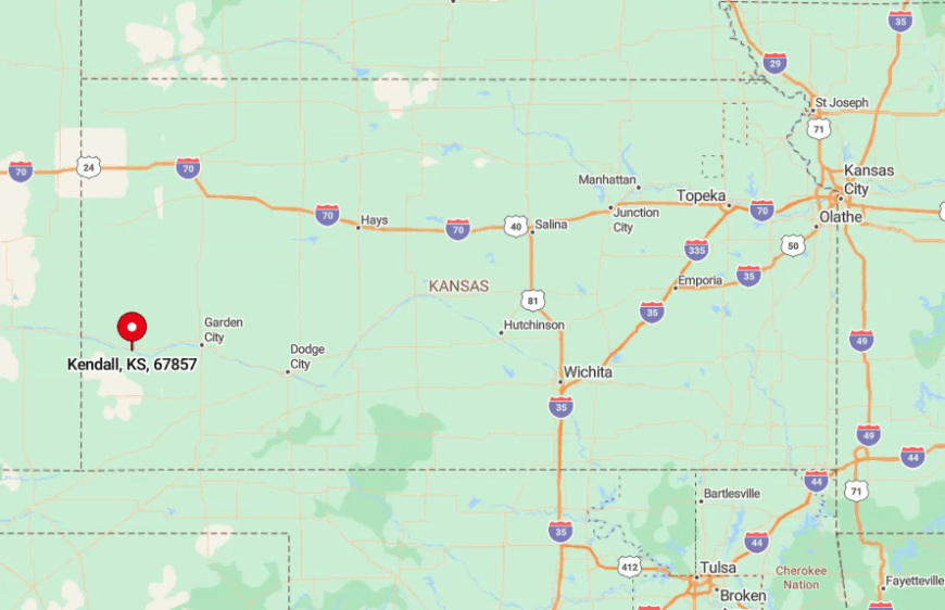
Kendall sits in southwestern Hamilton County, midway between Lakin and Coolidge but nowhere near a major junction. The Arkansas River meanders on three sides, requiring low-traffic bridges for access.
Most travelers exit K-25 onto a gravel spur that dead-ends at town, reinforcing the feeling of reaching a cul-de-sac in the prairie. Winter storms can make the final miles impassable, so residents keep an eye on forecasts.
6. Moscow – Grain Elevators Rising from an Ocean of Wheat
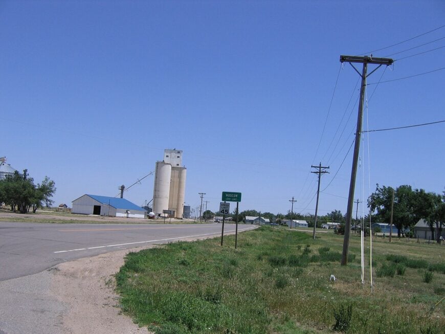
About 290 people call Moscow home, dominated by two towering concrete elevators visible for ten miles. Activities revolve around Friday night high-school sports, bird-watching on the nearby Cimarron National Grassland Auto Tour, and sunrise photography when golden wheat meets pink skies.
Grain handling and custom harvesting crews fuel the local economy with a dash of oilfield trucking. The town feels remote because the nearest larger community, Hugoton, is 25 miles away along a two-lane blacktop that sees more tumbleweeds than cars.
Broadband speeds lag city norms, and radio stations fade to static. Still, residents savor that very quiet, claiming they can hear a train horn in Guymon on still mornings.
Where is Moscow?
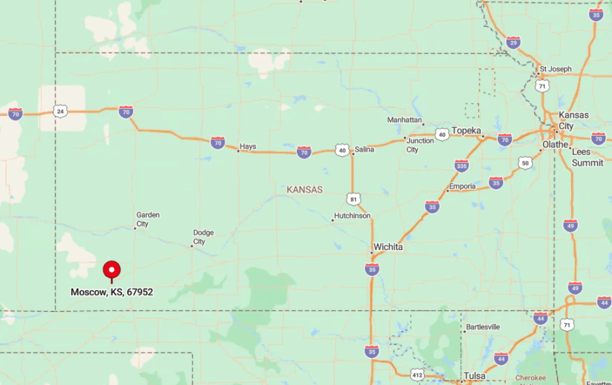
Moscow sits near the Stevens-Grant county line on Kansas Highway 56, forty minutes north of the Oklahoma Panhandle. Flat farmland surrounds it on all sides, allowing uninterrupted vistas that make the elevator feel like a lone skyscraper.
Reaching town involves a straight shot on 56, then a single turn onto Main Street, where angled parking spots are rarely full. Because there is no motel, overnight guests often camp at forest service sites in the grassland fifteen miles south.
5. Kalvesta – Lone Crossroads Framed by Chalky Bluffs
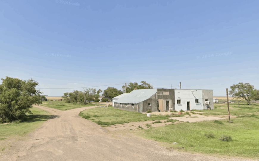
Kalvesta’s recorded population barely reaches 50, yet a handful of ranch houses cling to a crossroads marked by a vacant stucco schoolhouse. Travelers drive out to photograph gypsum-chalk outcrops glowing white against blue sky, hunt for fossils in draw bottoms, and walk the prairie dog towns east of town.
Ranching and custom haying form the slim economic base, while a once-a-week mail delivery keeps addresses official. More than half the surrounding land remains native grass, so horizons stay uncluttered and cell towers are scarce.
No state highway passes through, with only gravel Gant and Sod roads converging here. Nights feel endless, broken only by wind whistling through cedar fence posts.
Where is Kalvesta?
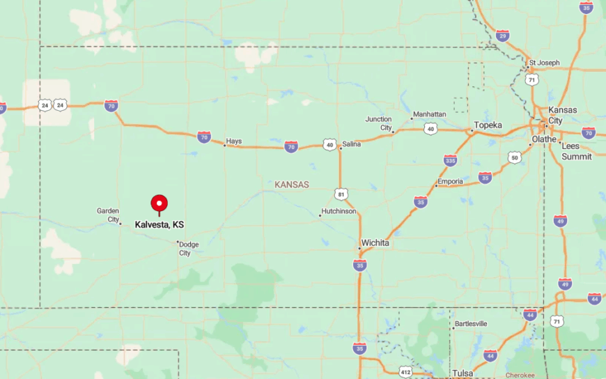
Kalvesta sits in north-central Finney County, twenty-three miles north of Garden City but hidden behind rolling bluffs that block the skyline glow. Travelers exit US 83, then follow county roads that shift from pavement to caliche before settling.
During wet spells, the last two miles can turn to gumbo, underscoring its isolation. Most GPS apps advise keeping a tow strap handy if rain is in the forecast.
4. Rolla – Wind-Turbine Horizon above a Wide-Lot Farm Community
Rolla’s roughly 380 residents enjoy large residential lots and vintage storefront murals that depict dust-bowl history. Families attend summer swimming lessons at the town pool, explore Cimarron National Grassland trails nearby, and sip coffee at the renovated 1930s bake shop that still uses a wood-fired oven.
Wheat, sorghum, and newer wind-energy leasing shape local income, creating an intriguing blend of old farm life and renewable tech. Although K-51 passes south of town, Rolla sits fifteen miles from the nearest four-lane highway, maintaining an unhurried pace.
Wind turbines dot distant ridges, yet their gentle whoosh only underscores the quiet. Evening softball games under metal-halide lights echo across empty blocks.
Where is Rolla?

Rolla rests in northern Morton County, nine miles from the Oklahoma line and thirty miles from Colorado, effectively placing it in a tri-state pocket. Surrounding grassland and Conservation Reserve Program acres form buffer zones that limit sprawl.
Visitors generally reach Rolla by following K-25, then cutting west on a paved spur into town. With no stoplights and one gas pump, it is easy to realize just how alone you are once the sun goes down.
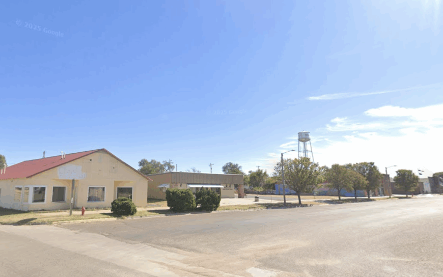
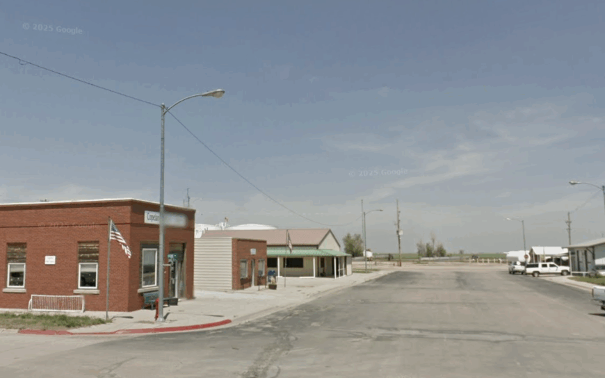
3. Copeland – Quiet Elevator Town Guarded by a Tin Water Tower
Copeland’s population hovers near 300, clustered around a silver water tower that has guided pilots since the 1940s. Locals gather at the community museum, fish at HorseThief Reservoir thirty minutes away, and savor homemade pie at the senior center’s monthly lunch.
Farming and seed cleaning dominate the economy, supported by seasonal pheasant hunting that draws a handful of visitors each fall. Copeland feels secluded due to its position on sparsely traveled K-190 and the miles of sorghum that stretch beyond town limits.
Streets turn dark after 9 p.m., punctuated only by the slow clicking of rail crossing signals as a grain car rolls by. The sky’s western half remains uninterrupted right down to sunset.
Where is Copeland?
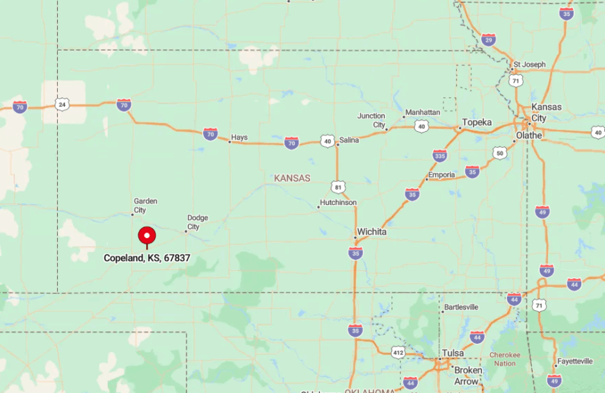
Copeland lies in Gray County, sixteen miles southwest of Montezuma and almost an hour’s drive from Garden City’s commercial strip. The town is bracketed by shelterbelts and massive circles of irrigated crops that mask it from passing motorists.
Most visitors arrive via K-190 or county road DD, stopping briefly to photograph the elevator before heading on. Passenger service ended decades ago, so arriving by car is the only realistic option.
2. Kismet – Remote Gateway to the Panhandle with 360-Degree Sky
Roughly 450 residents reside in Kismet, a grid of ranch homes anchored by a 1918 native-stone Methodist church. Popular pastimes include attending Southwestern Heights High football games, bird-watching at the nearby Arkalon Park wetlands, and browsing for antiques in the volunteer-run depot shop.
Farming, custom cattle feeding, and school district employment provide most paychecks, with a smattering of oil-patch work. Seclusion arises from its setting on a low-traffic state road and the prairie seas that surround the town in every direction.
There are no big-box stores, and the nearest movie theater sits thirty miles away in Liberal. Calm evenings reveal a sky so wide that a single thunderhead can occupy half of it.
Where is Kismet?
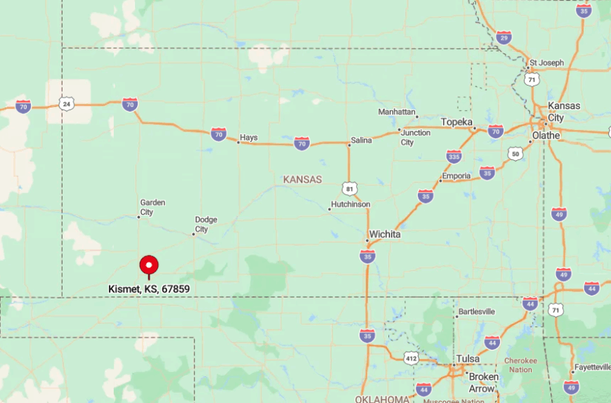
Kismet stands in eastern Seward County along Kansas Highway 54, yet the highway bypasses the residential grid by several hundred yards, reducing traffic noise.
Open fields and Conservation Reserve acres ensure unobstructed sightlines that add to its remote feel. Drivers usually reach town from Liberal in the west or Meade in the east, then pull onto Main Street to find angled parking always available. Bus routes do not serve the area, so visiting requires a private vehicle.
1. Elkhart – Tri-State Edge Town Surrounded by Cimarron National Grassland
Elkhart, the largest on our list with about 1,800 residents, clings to Kansas’s southwest corner just two miles from Oklahoma and eight from Colorado.
Residents bike shaded streets, explore 100,000 acres of adjacent Cimarron National Grassland, and hunt for Santa Fe Trail markers hidden among yucca and buffalo grass. Agriculture and grassland-related tourism drive the economy, supplemented by U.S. Customs jobs at the small airport that monitors nearby border airspace.
Despite its relative size, Elkhart feels secluded because the grassland wraps three sides of town, and the closest interstate interchange is over seventy miles away.
Nightlife consists of community theater at the historic Morton County Civic Center or a quiet drink under astonishing stars. The sense of frontier edge is palpable, reminding visitors why hardy homesteaders once called this place No Man’s Land.
Where is Elkhart?
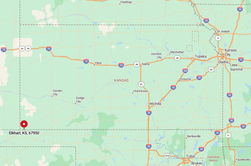
Elkhart sits at the junction of US 56 and K-27, but both highways shrink to two lanes well before reaching town. The surrounding Cimarron National Grassland acts as a giant buffer, preventing sprawl and muffling traffic.
Commercial flights land four hours away in Amarillo, so most arrivals involve a long, scenic drive across open country. Those who make the journey are rewarded with prairie solitude and a three-state photo op just outside city limits.