Would you like to save this?
Southern South Dakota holds a quiet side that often slips past travelers speeding between Mount Rushmore and the Missouri River. Away from the interstates sit tiny communities where prairie winds drown out traffic, corner cafés double as post offices, and night skies shine without a single streetlamp to dull the view.
These places are not ghost towns, yet they flirt with that label, sustained by ranch work, wheat, and a fierce fondness for room to breathe. We explore 25 such towns, counting down to the most out-of-the-way settlement, and share what life looks like once crowds fade from the rear-view mirror.
Expect a mix of boarded-up storefronts, roadside curiosities, and unexpected slices of history that reward anyone willing to take the long way around. Slip off the main road and discover where South Dakota still feels wonderfully remote.
25. Batesland – Prairie Crossroads with Lakota Roots
Batesland rests quietly on the Pine Ridge Reservation, its handful of streets surrounded by miles of open grassland that hums under prairie wind. Seclusion comes from the long distances between here and any larger town, with the nearest grocery more than 30 miles away.
The vibe is neighborly and deeply rooted in Lakota culture, with community gatherings at the school gym and traditional art sold at seasonal markets. Visitors can photograph the historic water tower, drive backroads where meadowlarks are more common than cars, or attend a local powwow when the season allows.
Ranch work and tribal programs form the main economic threads. At night, the horizon glows only with moonlight, offering an unbroken dome of stars. It’s the kind of place where stillness feels like part of the land itself.
Where is Batesland?
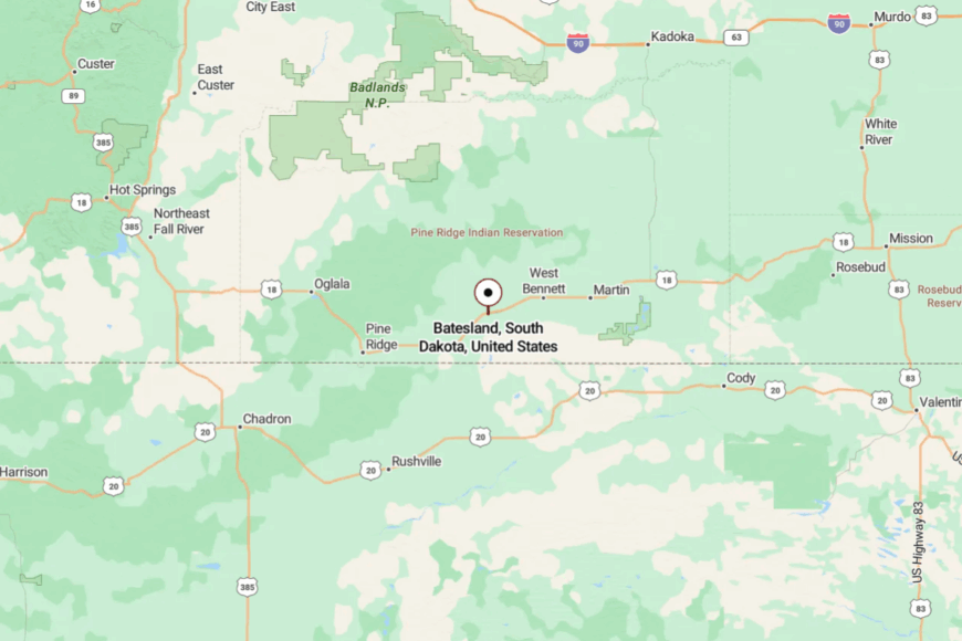
In the far southwest corner of the state, Batesland sits about 22 miles west of Martin along US Highway 18. Approaching from either direction means a long stretch of two-lane road through open prairie.
Traffic is minimal, and the views are endless. The closer you get, the more you understand why life here moves at its own pace.
24. Dallas – Small-Town Storybook on the Prairie Edge

Dallas is a tiny grid of streets just west of Gregory, where windbreak trees shield clapboard houses and gardens from the constant prairie breeze. Its removed feel comes from being bypassed by the main tourist routes, with US 18 slipping past miles to the south.
The town’s mood is simple and nostalgic—kids riding bikes on empty streets, church bells marking the hour, and neighbors swapping garden produce. Visitors can enjoy pie at the café, stop by the old grain elevator for photos, or explore nearby pheasant hunting grounds.
Farming dominates the economy, with wheat and corn fields pressing right up to town. On a summer night, fireflies outnumber porch lights. It’s the kind of quiet that makes you linger.
Where is Dallas?
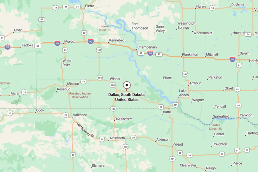
Set in Tripp County, Dallas lies about 5 miles west of Gregory along State Highway 44. The road in passes through gently rolling farmland with hardly a billboard in sight.
Few cars pass in a day, and the horizon stays wide. Arriving feels like stepping back a generation or two.
23. Herrick – Grain Silos and Gravel Lanes

Herrick is little more than a scattering of homes, a church, and a few towering silos standing sentinel over the surrounding fields. Seclusion here is born from the absence of any major road—visitors must intentionally turn down the gravel to find it.
The mood is quiet and self-reliant; most residents farm or commute to nearby Burke or Gregory. Travelers might stop for a photo of the historic school building, walk the grid of streets, or watch hawks circle over cut fields.
Harvest season is when the place hums; otherwise, it’s all wind and songbirds. The simplicity of life here gives Herrick an enduring charm. It’s a reminder of how small a community can be and still thrive.
Where is Herrick?
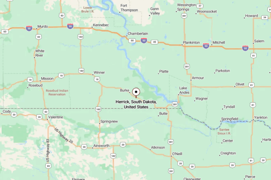
Located in Gregory County, Herrick sits about 6 miles east of Burke on county-maintained gravel roads. The approach passes through wide swaths of cropland with no landmarks until the silos appear.
You won’t stumble upon it without looking. That makes every arrival feel intentional.
22. Carter – Sleepy Junction on the Open Range

Carter is an unincorporated dot along US Highway 183, where cattle outnumber residents and the nearest store might be twenty miles away. Its seclusion is tied to its role as a simple service stop for the surrounding ranches—no main street, no stoplight, just a few buildings and endless sky.
The vibe is pure prairie: wind-swept grass, the scent of hay, and the sound of a distant semi once in a while. Stop for fuel, snap photos of weathered barns, or use Carter as a launch point for scenic drives toward the White River.
The economy turns on ranching and seasonal labor. Even a short visit leaves the impression of a place untouched by rush or clutter.
Where is Carter?

Carter rests in Tripp County, about 18 miles north of Winner along US 183. Approaching from the south, the road rolls over low ridges with cattle grazing on both sides.
With little signage and no traffic lights, it’s easy to miss if you’re not watching. And that’s exactly how locals like it.
21. Witten – Shelterbelt Quiet

Witten’s cluster of homes sits behind thick lines of cottonwood and spruce, planted decades ago to break the prairie wind. It’s secluded partly by design—State Highway 53 skirts the town entirely.
The mood is rural and comfortable, where front porches double as living rooms on summer nights. Visitors can wander quiet streets, photograph the old school gym, or head into nearby hunting lands for pheasant season.
Farming and a touch of game tourism keep things going. Between the shelterbelts and the slow pace, Witten feels cocooned from the outside world. It’s the kind of hidden corner that only locals and map-readers find.
Where is Witten?

Set in Tripp County about 14 miles northwest of Winner, Witten is reached via county gravel roads branching off Highway 183. The approach winds through farmland and past grain bins.
Once you pass the tree line, you’re in town. It feels like a place intentionally tucked out of sight.
20. Kennebec – Missouri Plateau Outpost

Kennebec holds fewer than 300 residents but serves as a lifeline stop on Interstate 90 for those who know it’s there. Its isolation is relatively close to the highway but buffered by open fields and sheltering hills.
The vibe blends prairie pragmatism with a touch of small-town friendliness; the café doubles as the social hub, and the grain elevator marks the skyline. Visit the local historical society, fish nearby Lake Byre, or take the backroads into the hills south of town.


Agriculture and highway services are the anchors here. It’s just enough bustle to feel alive without losing its quiet.
Where is Kennebec?

Located in Lyman County, Kennebec sits just north of I-90, about 25 miles west of Chamberlain. Exit 235 leads directly into town on a two-lane spur.
Once you turn off, traffic drops away immediately. The horizon opens, and the pace slows.
19. Presho – Prairie Town with a Main Street Heart

Would you like to save this?
Presho stretches along US Highway 16, a neat row of shops, cafés, and civic buildings framed by grain silos. Its relative seclusion comes from being 15 miles from the nearest interstate exit, leaving it off most travelers’ radar.
The town’s personality is community-driven and warm, with summer baseball games and harvest parades. Visitors can browse the local museum, sample pie at the café, or take in the view from nearby hills.
Farming is the backbone, but small businesses give it a pulse. Even at midday, the hum is never more than a murmur.
Where is Presho?

Presho lies in Lyman County, about halfway between Chamberlain and Murdo on US 16. Approaches from either direction are long and lightly trafficked.
The highway narrows as you enter town, signaling a slower rhythm. The surrounding prairie keeps the horizon wide and uncluttered.
18. Pukwana – Duck Races and River Breezes

Pukwana is a river-adjacent community known to insiders for its summer duck races down a narrow chute in the park. Its seclusion comes from being a few miles off I-90 and oriented more toward the Missouri River than the interstate.
The vibe is playful yet quiet—residents gather for Friday night suppers, kids bike to the ballfield, and fishermen head for nearby bays. Stop at the quirky roadside café, stroll past tidy lawns, or explore the old grain mill.
Farming, fishing, and small trade keep the lights on. On warm evenings, the breeze from the river cools the whole town.
Where is Pukwana?
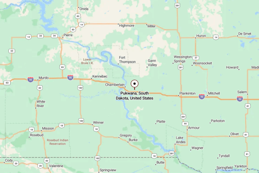
Located in Brule County, Pukwana sits about 7 miles east of Chamberlain along US 16. From the interstate, you take the exit and wind through a short stretch of farmland before the first houses appear.
The Missouri River lies just to the west, lending a soft edge to the horizon. It’s a place you find—and remember—by accident.
17. Kimball – Quiet Junction with a Friendly Wave

Kimball serves as a low-key junction between I-90 and SD 45, though the interstate noise fades quickly once you reach Main Street. Its seclusion is found in the slower, backstreet pace just a block from the highway.
The vibe is open and friendly, with folks waving from pickups and kids walking to the pool in summer. Visit the local history museum, grab ice cream from the drive-in, or head out on gravel for sunset photos over the prairie.
Agriculture and passing trade keep it steady. Even travelers who stop for a break often linger longer than planned.
Where is Kimball?

In Brule County, Kimball sits about 35 miles west of Mitchell along I-90. Exit 284 drops you right at the edge of town.
Beyond the interstate, the world shrinks to a few slow streets. The fields wrap it up like a comforter.
16. Lesterville – Czech Heritage in a Countryside Pocket

Lesterville is a small, tight-knit farming community where Czech heritage shows in bake sales, church suppers, and polka nights at the hall. Its secluded feel comes from being far from interstates and tucked into the rolling cropland of Yankton County.
The vibe is festive yet unhurried, with laughter spilling from gatherings and the scent of kolaches in the air. Visitors can attend a local festival, photograph the historic church, or take scenic drives to the Missouri River bluffs.
Farming remains the economic backbone. It’s a cultural oasis wrapped in quiet fields.
Where is Lesterville?
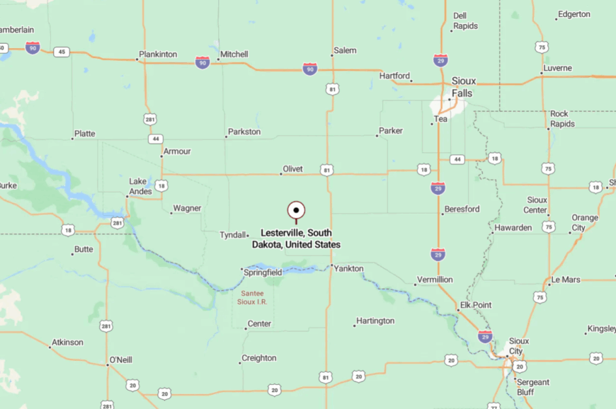
Set in southeastern South Dakota, Lesterville is about 15 miles northwest of Yankton via State Highway 46. County roads narrow as you approach, lined with corn and bean fields. The journey feels timeless. By the time you arrive, the rest of the world feels far away.
15. Tabor – Riverside Village with Old-World Charm

Tabor blends old-world charm with prairie simplicity, its main street lined with Czech-influenced storefronts and tidy gardens. Its seclusion is helped by its location well south of major east-west routes, oriented instead toward the Missouri River.
The vibe is colorful and community-focused, with festivals, church picnics, and folk music filling the calendar. Visitors can attend the annual Czech Days celebration, explore the local museum, or wander riverside trails.
Agriculture and heritage tourism share the economic stage. It’s the kind of place where history feels very much alive.
Where is Tabor?

Tabor lies in Bon Homme County, about 18 miles west of Yankton along State Highway 50, then south on State Highway 52. The approach rolls through rich farmland before dropping into a gentle valley near the river.
Roads are quiet, and the pace is slower still. It’s close to the water, but far from the noise.
14. Springfield – Blufftop Town Overlooking the Missouri

Springfield sits high above the Missouri River, where bluffs offer sweeping views and the wind carries the scent of water. Its removed feeling comes from being near the river but away from main travel routes, with most visitors arriving on purpose.
The mood is relaxed and scenic, with a riverside park, historic buildings, and a small college campus adding character. Spend an afternoon fishing, tour the Springfield State Recreation Area, or explore the blufftop trails.
Local life blends education, agriculture, and recreation. Sunsets here feel like they belong only to you.
Where is Springfield?

Located in Bon Homme County, Springfield lies about 12 miles south of Tyndall via State Highway 37. Approaching from the north means descending into a tree-lined valley before climbing to the blufftop.
The Missouri River curves quietly below. It’s an arrival that feels like a reward.
13. Avon – Grain, Green, and Good Neighbors

Would you like to save this?
Avon is a compact town surrounded by a sea of grain fields, with streets shaded by mature trees and a downtown that hasn’t changed much in decades. Its seclusion is geographical—miles from the nearest four-lane and wrapped in farmland.
The vibe is wholesome and cooperative, with neighbors pitching in on harvests and gathering at the café. Visitors can catch a Friday night ball game, browse the local thrift shop, or drive scenic loops through the surrounding countryside.
Farming anchors the economy, with a few small businesses on Main Street. Life here moves to the rhythm of the land.
Where is Avon?

In Bon Homme County, Avon sits about 20 miles southwest of Tyndall via State Highway 50 and county roads.
The approach is a patchwork of gravel and pavement, with fields stretching to the horizon. There’s no rush to get here. That’s part of the charm.
12. Tripp – Prairie Town with a German Accent

Tripp is a prairie town where German heritage shows in family names, local cooking, and summer polka dances. Its secluded feel comes from being a bit off the main routes, with State Highway 37 skirting just east of town.
The mood is friendly and tidy—well-kept lawns, painted shutters, and a downtown anchored by the elevator. Visit the local museum, attend a community dance, or explore nearby hunting lands.
Agriculture drives daily life. It’s a place where traditions hold steady against the winds.
Where is Tripp?

Located in Hutchinson County, Tripp is about 15 miles south of Parkston via State Highway 37. The route takes you past rolling cropland and through stands of shelterbelt trees.
The town appears gradually from the fields. And once you arrive, the quiet takes over.
11. Menno – Small but Sturdy on the Prairie

Menno feels sturdy and settled, its main street lined with brick buildings and wide enough for a parade. Its seclusion comes from being 20 miles from the nearest city and hemmed in by farms on all sides.
The vibe is steady and practical—hardware stores, cafés, and a strong sense of community pride. Visitors can attend the summer Pioneer Power Show, tour the local museum, or explore the countryside on gravel loops.
Agriculture is the backbone, with a dose of heritage tourism. Menno holds fast to its roots, even as the prairie shifts around it.
Where is Menno?

Set in Hutchinson County, Menno sits about 20 miles southwest of Yankton via State Highway 18 and county roads. The approach is a series of long, straight stretches lined with crops.
Each mile feels quieter than the last. By the time you reach Main Street, the rest of the state feels far away.
10. Allen – Isolated Reservation Village Surrounded by Prairie Seas
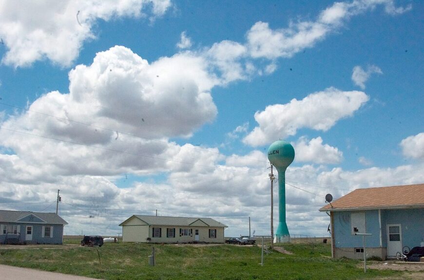
Allen counts roughly 420 residents, most of whom are part of the Oglala Lakota community. Visitors find the Pass Creek Church murals, local beadwork stands, and wide-open land perfect for bird-watching and sunrise photography.
Daily rhythm centers on tribal services, small-scale ranching, and jobs with the nearby tribal school. Grain fields and native grass stretch for miles, and the lack of any sizable town within a forty-minute drive keeps outside noise away.
Nights fall silent enough for coyotes to be heard from every direction. The combination of cultural roots and extreme distance from commercial corridors makes Allen one of the quietest spots on the Great Plains.
Where is Allen?

The village sits on the eastern side of the Pine Ridge Reservation, about 30 miles northeast of Wanblee. Low hills and unpaved roads act as buffers, adding to the sense of separation.
The simplest approach is by State Highway 18 to BIA Route 41, though pavement yields to gravel long before arrival. Limited signage means a good map or pre-downloaded GPS data is wise.
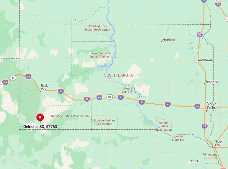
9. Oelrichs – Southern Hills Enclave with More Horses than People

Oelrichs hosts around 120 inhabitants, yet its summer rodeo draws far more horses than residents. Travelers can explore Cold Brook Reservoir for fishing, hike the southern edge of the Black Hills, or sift through antiques at the volunteer-run depot museum.
Cattle and hay define the economic landscape, with a few residents commuting north to Hot Springs for work. The town square holds only a café, a gas pump, and a handful of tidy homes set behind windbreak trees.
Encircling ponderosa ridges block highway sounds and funnel sweet pine scent across the valley. That topography, coupled with sparse traffic on US 18, preserves a stillness rare in the hills.
Where is Oelrichs?
Would you like to save this?
Located 12 miles south of Hot Springs on US 18, Oelrichs nestles against the first foothills rising from the prairie. The ridge line hides it from view until the last minute, amplifying the feeling of discovery.
Driving in, one passes open range gates and cattle grids that slow progress and remind motorists they are entering ranch country. Rapid City Regional Airport sits 70 miles north, but the final stretch is all two-lane blacktop and cattle trails.
8. Ideal – Appropriately Named for Absolute Country Calm

Ideal claims fewer than 100 full-time residents, though brandings and community suppers swell numbers on certain weekends. Locals gather for trap-shoot leagues at the township range, picnic under a lone cottonwood outside the tiny Methodist church, and fish farm ponds stocked with crappie by generous neighbors.
Cattle grazing and custom hay cutting form the backbone of income here. Houses rest on multi-acre lots, and porch lights are so spread out that meteor showers blaze across the sky unchallenged.
Sounds rarely rise above a distant tractor or meadowlark. The absence of both rail and highway traffic cements Ideal’s near-perfect hush.
Where is Ideal?

The hamlet sits 13 miles north of Winner along County Road 19, surrounded by rolling pasture broken only by barbed wire. Elevated ridges shield the area from the faint rush of State Highway 44 to the east.
Reaching it involves a steady climb on gravel that forces drivers to slow and watch for loose cattle. Winter snow often drifts waist-deep across the final mile, leaving the settlement entirely to itself until plows arrive.
7. Belvidere – Old Railroad Stop Turned Remote Retreat

Belvidere holds about 50 residents, most living in ranch houses scattered well beyond the one-block business district. Travelers detour here for the Prairie Homestead museum, photo ops at the boarded-up Milwaukee Road depot, and stargazing on gravel pull-offs overlooking the white-clay buttes.
Ranching and a modest motel at Interstate 90 exit 170 supply modest employment. Vacant lots where rail spurs once stood now host mule deer instead of freight.
Sweeping badlands terrain stretches in every direction, breaking radio signals and hiding light pollution. The ghost-town aesthetic merges with prairie solitude to give Belvidere an otherworldly peace.
Where is Belvidere?
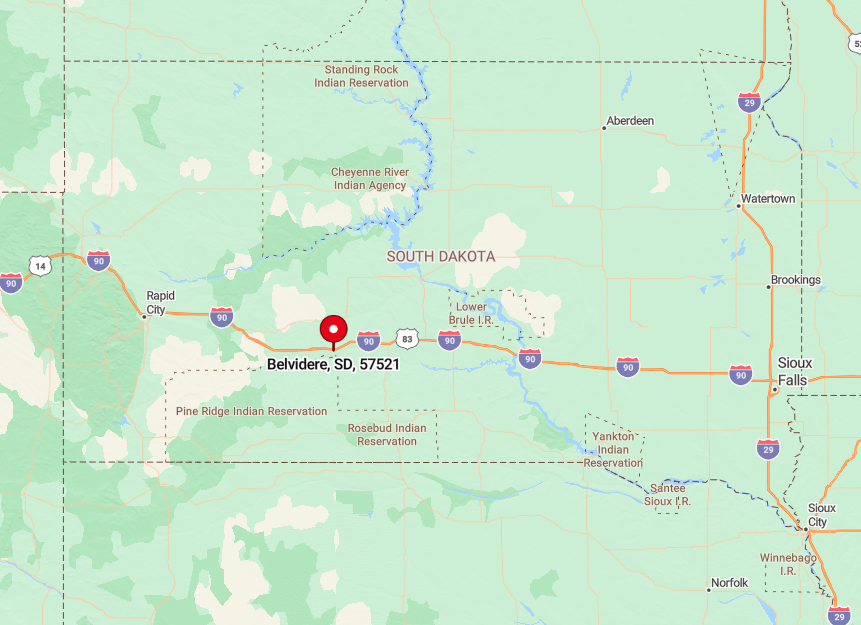
The town sits 45 miles west of Kadoka, just north of the Badlands Wilderness boundary. Interstate 90 lies two miles south, yet a tall ridge cuts off highway noise entirely.
Visitors leave the interstate, climb a dusty incline, and feel civilization fade behind them. Except for a single gas station, there is nothing but grass and gullies for twenty miles in any direction.
6. Vivian – Windswept Crossroads Far from Interstate Bustle

Vivian counts around 110 residents and holds the state record for the largest hailstone ever documented, a quirky claim celebrated at the local café. Passersby fish Medicine Creek, visit the vintage Sinclair station turned photo spot, or join locals for Friday steak night at the grain elevator’s lounge.
Wheat, sunflowers, and a trio of towering silos dominate the skyline and the economy alike. The nearest highway exit sits roughly 17 miles away, keeping tourist traffic nonexistent.
Stretches of treeless prairie let the wind sweep through without stopping, creating a natural white-noise machine of rustling grass. That isolation makes Vivian feel much farther from the outside world than a map suggests.
Where is Vivian?

Perched at the junction of US 83 and State Highway 248, Vivian lies 30 miles south of Pierre yet feels cut off by sheer openness. The rolling plains form a wind tunnel that drowns out distant road noise.
Travelers reach town via US 83, then detour onto the original pre-interstate alignment to find the café and elevator. Winter storms often close Highway 248 first, sealing Vivian off until plows swing through.
5. Colome – Tiny Farm Town Wrapped in Wheat Fields

Colome’s population hovers near 550, and nearly everyone meets at the school gym on game night to cheer the Cowboys. Visitors can hunt pheasant on surrounding public-access land, dig into homemade doughnuts at the Main Street bakery, or explore vintage fire trucks in the volunteer department’s shed.
Farming rules here, with wheat, corn, and soybeans filling bins that line the rail spur. The single commercial strip ends abruptly in shoulder-high grain, and horizon-to-horizon crops buffer the town from outside bustle.
Train horns echo only a few times per week when the short line rolls through. The rest of the time, silence settles like dust on the brick storefronts.
Where is Colome?

Colome sits on US 18 thirty miles west of Winner in Tripp County. Shelterbelts of cottonwood block prairie winds and hide the highway from most homes.
The east-west route sees occasional truck traffic, yet Colome’s position off the tourist corridor to the Black Hills keeps volumes low. Visitors flying into Sioux Falls still face a three-hour drive through open farmland before the town elevator appears on the skyline.
4. Parmelee – Quiet Reservation Community on Endless Plains

Parmelee shelters roughly 530 residents along a modest grid of gravel lanes. Families gather for summer hand-game tournaments, powwow practice at the community center, and softball under portable lights. Most employment ties to the Rosebud Sioux Tribe, education services, or seasonal ranch work.
Houses stand widely spaced, giving children whole acres for front yards and keeping neighbor noise to a minimum. Surrounding grassland forms a natural sound wall broken only by meadowlark calls. That buffer, plus a lack of through roads, locks in an almost meditative stillness.
Where is Parmelee?

The town rests in Todd County, 20 miles northwest of Mission, positioned deep within reservation land. State Highway 63 bends around it, meaning nobody passes through unless they intend to.
Travel requires slow driving on well-worn pavement that narrows to one lane in places. During heavy rain, the prairie gumbo turns slick, often persuading visitors to delay plans until the sun returns.
3. Interior – Prairie Living at the Doorstep of Badlands National Park

Interior lists about 70 full-time residents, yet its summertime rodeo swells attendance tenfold. The town offers sunrise jeep tours into the White River Badlands, fossil talks at a tiny visitor center, and cold drinks at the century-old Horseshoe Bar.
Seasonal tourism supports a café, campground, and a few park-service jobs while cattle ranching fills most calendars the rest of the year. Homes sit on spacious lots broken by alleys of hardy juniper that temper the relentless wind.
Outside the grid, dirt roads stretch for miles without a mailbox in sight. With the nearest traffic light more than fifty miles away, Interior’s quiet feels almost prehistoric.
Where is Interior?

Just south of the Badlands Loop Road, Interior lies 38 miles southeast of Wall via State Highway 44. The town is tucked below a bluff that blocks sight and sound from the occasional tourist coach above.
Visitors leave the pavement quickly, crossing cattle guards before reaching Main Street. Rail remnants and coulees isolate the place further, and arriving feels like stepping through a back door into the National Park.
2. Buffalo Gap – Hidden Between Custer’s Hills and the Grasslands

Buffalo Gap counts around 130 residents scattered across a neat grid of false-front buildings dating to the 1880s. Travelers stop for cinnamon rolls at Buffalo Gap Trading Post, kayak at French Creek Recreation Area, or photograph the 1908 Sandstone Jail that still stands without modern locks.
A handful of woodworking shops and small ranches supply most livelihoods, while a volunteer fire brigade keeps civic pride alive. Rolling hills northward and Buffalo Gap National Grassland to the south create a sound buffer wider than many counties.
Pheasant flushes, not car horns, break the afternoon calm. The absence of lodging chains or fast-food signs seals its sense of remoteness.
Where is Buffalo Gap?

The town sits 20 miles south of Custer via a winding county road that snakes through granite outcrops. Hills rise abruptly on three sides, hiding the settlement from tourists rushing to Wind Cave National Park nearby.
Getting there demands leaving US 385, crossing a one-lane wooden bridge, and trusting hand-painted mileage posts. Winter ice often closes that bridge, turning Buffalo Gap into a cul-de-sac until thaw.
1. Scenic – Almost a Ghost Town on the Edge of the Badlands

Scenic’s population tops out at roughly 12 year-round residents, with more vacant buildings than occupied ones lining its dusty Main Street. Visitors photograph the weathered jail wagon, sip sarsaparilla at the Longhorn Saloon when it opens on summer weekends, and ride horses across nearby Indian Creek wildlife plots.
Limited seasonal park jobs and small-scale ranch leases provide the few paychecks in town. Storefronts stand empty, giving prairie winds full license to whistle through broken windows and amplify the sense of abandonment.
Nights reveal Milky Way views bright enough to cast shadows on the cracked boardwalk. Silence reigns, broken only by freight trains sliding past on the distant BNSF line.
Where is Scenic?

Scenic lies 50 miles east of Rapid City along State Highway 44, perched on the very edge of Badlands National Park’s North Unit. The closest gas station is 25 miles away, and cell coverage fades to zero five miles outside town.
Drivers follow the paved highway until it narrows, then cross cattle guards that signal entry into open range where bison sometimes wander. With no alternate routes and few visitors, Scenic remains an island of quiet surrounded by 379 square miles of nearly empty prairie.