🔥 Would you like to save this?
Southern Maine is known for its rocky coastline and seaside villages, yet just a few miles inland a quieter world still thrives. Small lakes shimmer behind thick pine curtain walls, gravel lanes wander between stone walls, and tiny villages carry on without the rush of chain stores or highway glare.
The following twenty five towns share a talent for staying tucked away, each offering its own flavor of stillness, scenery, and neighborly calm. From hilltop orchards to cabin-lined ponds, they remind visitors that silence can feel spacious rather than empty.
In order to come up with the very specific design ideas, we create most designs with the assistance of state-of-the-art AI interior design software. Also, assume links that take you off the site are affiliate links such as links to Amazon. this means we may earn a commission if you buy something.
We invite readers to picture chirping loons instead of car horns and fields of lupine instead of parking lots. A closer look at each place reveals why life here moves at a gentler pace.
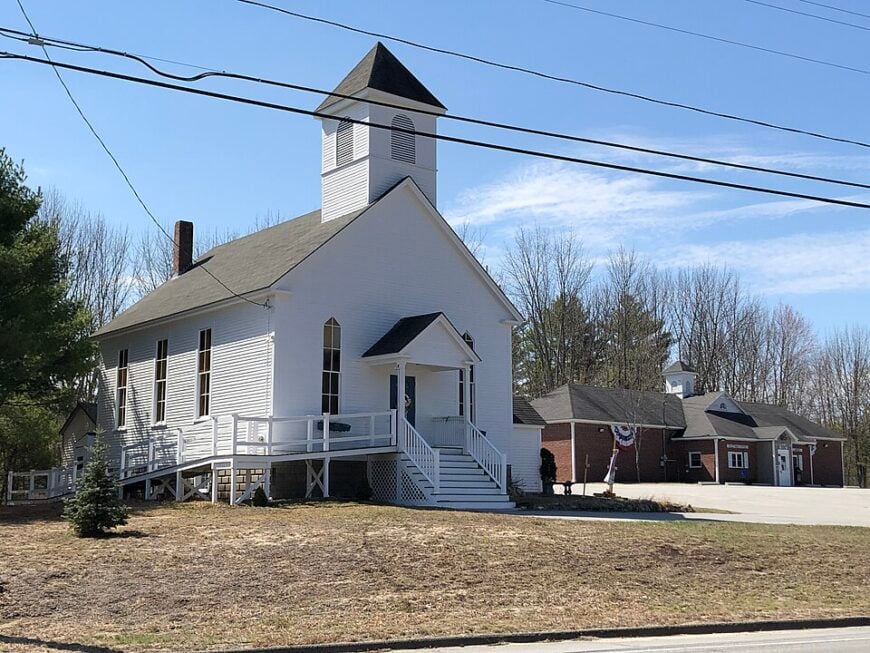
25. Dayton – Marshland Stillness Near the Saco Headwaters

Set along the winding Saco River and wrapped in thick forest, Dayton drifts quietly just beyond Maine’s coastal bustle. With no major highways cutting through and only a scattering of backroads connecting it to the outside, the town feels gently hidden.
Life here moves at a slower pace—marked by the scent of woodsmoke, the sound of rustling trees, and the ripple of river water. Locals hike or ski the trails at Harris Farm, paddle the river, or visit the maple sugarhouses come spring.
A historic schoolhouse still stands as a quiet nod to Dayton’s roots. Farming and small trades keep the town grounded. It’s the kind of place that doesn’t ask much—just that you breathe, slow down, and stay a little longer.
Where is Dayton?

Dayton is nestled in southern Maine, in York County, about 20 miles west of Portland and just northeast of Biddeford. It’s tucked between the Saco River and wooded backroads, accessible via ME-5 or a winding route off U.S. Route 202.
The drive there passes through farmland, river bends, and stands of pine, gradually softening the edges of daily noise. It’s a quiet corner that feels brushed in green, close enough to town yet quietly removed from its rhythm.
24. Alfred – Stone Foundations and Hidden Springs

Cradled by rolling hills and dense woodlands, Alfred sits quietly in southern Maine, far enough from the coast and cities to feel worlds away. Narrow country roads lead you past old barns, hidden ponds, and weathered stone walls, giving the town a hushed, timeless quality.
The air smells like pine and earth, and the quiet is broken only by birdsong or the distant toll of church bells. Visitors might explore the Massabesic Forest trails, stop by Shaker Pond for fishing or kayaking, or visit the Alfred Shaker Museum to step back into a simpler past.
Antique shops and local farms offer a taste of the town’s rural rhythm. Many residents still work the land or serve the town in long-held family trades. It’s the kind of place where time stretches out—and you realize how much you’ve missed the sound of stillness.
Where is Alfred?

Alfred lies in southern Maine, in York County, about 30 miles southwest of Portland and just west of Sanford. It’s reached by U.S. Route 202, where the road dips through farmland, forests, and gentle hills before curving into the village center.
The journey trades the rush of highways for the hush of church steeples and antique homes framed by maples. It’s a town that feels cradled by the past, quietly set apart from the world just beyond its trees.
23. Waterboro – Pines, Ponds, and Paperbacks

Tucked between thick pine forests and scattered lakes, Waterboro lies just out of reach of Maine’s busier roads, giving it a hidden, almost private feel. Winding backroads lead through quiet neighborhoods and stretches of wilderness, where cell service fades and nature takes over.
The town feels rustic and grounded, where loons call across Little Ossipee Lake and fog clings to the treetops at dawn. Locals spend their days fishing or swimming at the lake, walking trails in the Waterboro Barrens Preserve, or stopping by a roadside farm stand.
Remnants of old mills and historic homes speak to a quieter, working past. Logging and small-scale farming still play a role in its economy. It’s the kind of place that doesn’t rush you—where the stillness settles in like an old friend.
Where is Waterboro?

Waterboro is located in southern Maine, in York County, about 35 miles west of Portland and just north of Sanford. It’s accessible via Route 5 or Route 202, where the road winds past lakes, wooded hills, and open stretches of rural land.
The approach shifts gently from busier towns to a quieter rhythm of pine shadows and glimpses of Little Ossipee Lake. It’s not far from anything—but it feels like a place that’s all its own.
22. Arundel – Hidden Fields Between Route 1 and the River

Nestled between coastal towns but set back just far enough, Arundel feels like a place quietly keeping to itself. Shielded by forested roads and dotted with family farms, it remains off the beaten path, even as nearby Kennebunkport draws the crowds.
The town has a pastoral calm—roosters in the morning, the scent of hay in late summer, and winding roads that always seem to lead to open fields. Locals visit the Arundel Barn Playhouse, bike rural backroads, or stop by farm stands that have been there for generations.
It’s a place rooted in agriculture, crafts, and quiet traditions. Here, the days move slowly, and the nights are still. It’s the kind of place you find by accident—and remember long after you’ve left.
Where is Arundel?

Arundel sits in southern Maine, in York County, just inland from the coast and about 25 miles southwest of Portland. It’s located along U.S. Route 1, just a few miles from Kennebunkport, yet feels tucked between salt air and rolling farmland.
The drive there winds through a mix of coastal byways and quiet country stretches, where antique barns and marshes catch the light. It’s close to the ocean’s edge, but just far enough back to feel quietly rooted in its own rhythm.
21. Hollis – Where the River Shapes the Roads

Surrounded by deep woods and split by the steady flow of the Saco River, Hollis sits quietly beyond Maine’s main travel routes, giving it a tucked-away, backwoods charm. Long stretches of forested road and scattered homesteads make the town feel private, even a little hidden.
The air is rich with the scent of pine and river stone, and the silence is often broken only by the hum of insects or the rush of water over rocks. Residents fish or kayak along the river, hike through the Hollis Community Forest, or gather at roadside farm markets.
Old stone walls and weathered barns speak to its farming past, while many locals still work close to the land. It’s a town that asks nothing of you—except to slow down and breathe.
Where is Hollis?

Hollis is located in southern Maine, in York County, about 20 miles west of Portland and just north of Saco. It’s reached via Routes 202 and 35, where the road winds through pine forests, farm fields, and over the Saco River.
The drive eases from town bustle into rural calm, with long stretches of quiet and tree-lined turns. It’s near enough for convenience, yet distant enough to carry the hush of deep Maine woods.
20. Lyman – Spruce Hollows and Seasonal Stillness

Tucked between woodlands and quiet lakes, Lyman sits just beyond Maine’s coastal rush, its gravel roads and open fields giving it a calm, off-grid feel. With no highways cutting through and only a handful of small businesses, the town drifts in its own rural rhythm.
Mornings bring the sound of birds and the sight of mist lifting off Kennebunk Pond, while evenings settle in with the hush of wind through the trees. Locals spend time boating or swimming at the pond, walking wooded trails, or stopping at apple orchards in the fall.
Farming still shapes much of the landscape, with generations tending land that hasn’t changed much in decades. It’s the kind of place where time stretches quietly—and life returns to the essentials.
Where is Lyman?

Lyman lies in southern Maine, in York County, about 30 miles southwest of Portland and just northwest of Biddeford. It’s reached via Route 111 or Route 35, with roads that pass through open farmland, dense woods, and scattered ponds.
The approach feels gradual and grounding, trading traffic lights for still stretches of two-lane road. It’s close enough to coastal towns, but quietly anchored in its own rural calm.
19. Buxton – Farms, Falls, and Forgotten Trails

🔥 Would you like to save this?
Down winding country roads and past stretches of forested hills, Buxton quietly unfolds, far from Maine’s coastal crowds and tourist lanes. Nestled along the Saco River and surrounded by old farmland, it feels like a place time forgot—in the best way.
There’s a grounded stillness in the air, where woodsmoke drifts from chimneys and the rhythm of daily life moves without hurry. Locals wander trails at Pleasant Point Park, cast lines into the river, or pick up fresh goods from roadside stands and family farms.
The town’s roots show in its stone bridges, historic churches, and weathered barns that have stood for generations. Some residents farm or run small trades, while others stay simply for the quiet. It’s the kind of place where you don’t just pass through—you linger, without needing to know why.
Where is Buxton?

Buxton is located in southern Maine, in York County, about 15 miles west of Portland and just north of Saco. It sits along Routes 202 and 112, where the road curves past rivers, forest edges, and old stone walls marking time.
The drive in feels familiar and unhurried, with village clusters giving way to wider, quieter spaces. It’s just beyond the city’s reach, but far enough to feel gently removed from it all.
18. Sanford Highlands – Upland Meadows Above the City

Perched on the quieter edge of Sanford and surrounded by dense forest and scattered hills, the Highlands feel like a place gently carved out of the woods. There’s no highway rush here—just winding roads, tall pines, and a sense of space that stretches in every direction.
The air is crisp, and the silence feels complete, broken only by birdsong or the distant rumble of a passing truck. Locals explore trails in the nearby woods, fish at local ponds, or gather for quiet evenings under wide, starlit skies.
While Sanford hums with activity, the Highlands remain a step removed—calm, residential, and self-contained. Some work in trades or commute to town, but many stay close, drawn to the land and the quiet it keeps. It’s the kind of place that feels like your own little corner of the world—hidden in plain sight.
Where is Sanford?

Sanford Highlands is a quiet neighborhood within the city of Sanford, in southern Maine’s York County, about 35 miles southwest of Portland. It’s tucked off Route 109, just north of Sanford’s downtown, where residential streets rise gently above the bustle below.
Reaching it means climbing through tree-lined roads and quiet turns, gradually leaving behind the hum of commercial corners. It’s close to everything, yet perched just high enough to feel like a world apart.
17. South Hiram – Where the Pavement Ends

Tucked near the New Hampshire border and surrounded by wooded hills and winding backroads, South Hiram feels like a place gently held apart from the rest of the world. With no major highways nearby and a landscape shaped by forest, farmland, and river bends, it’s easy to forget how close you are to anything.
The town breathes in a quiet rhythm—crickets at night, frost on old fence posts, and woodsmoke curling into the sky. Locals fish along the Ossipee River, hike nearby trails, or gather at the general store where the news still travels by word of mouth.
Logging, farming, and homesteading traditions still anchor many lives here. It’s a place where time slows down naturally, like the river that never rushes—and you remember how good stillness can feel.
Where is South Hiram?

South Hiram sits in western Maine, in Oxford County, near the New Hampshire border and about 40 miles west of Portland. It’s reached by Route 117, where the road narrows into winding curves that pass through thick woods and rolling hills.
The drive slows as you move farther from town centers, trading signs and traffic for streams, farmland, and quiet bends. It’s easy to reach—but it feels like you’ve arrived somewhere meant to stay quiet.
16. West Baldwin – Wild Ridges and One-Lane Roads

At the edge of winding hills and dense Maine forest, West Baldwin unfolds slowly—down backroads where the pavement fades and cell signals vanish. The town rests quietly between the Saco River and the shadow of the White Mountains, giving it a hushed, remote feeling that’s hard to find elsewhere.
Fields stretch wide beside weathered barns, and the air carries the scent of pine, woodsmoke, and earth after rain. Life here leans on the land—locals fish the river, tend small farms, or hike the trails that weave through the woods.
There’s no rush, just rhythm: sunrises over the hills, the hum of insects at dusk, and the steady beat of quiet work. Many still live by trade, farming, or simple routines handed down over time. It’s the kind of place where the world slows—and staying put feels like a gift.
Where is West Baldwin?

West Baldwin is located in western Maine, in Cumberland County, about 35 miles northwest of Portland and just east of the New Hampshire line. It’s accessed via Route 113 or winding backroads off Route 117, where forested hills rise and fall beside scattered farms and stone walls.
The approach is slow and scenic, with stretches of quiet road unfolding between pines and pastures. It’s not far from the world—but it feels like a pocket of stillness tucked into the hills.
15. Eliot – Salt Marsh Edges and Oak-Lined Silence

Just inland from the bustle of the seacoast, Eliot hides in plain sight—shielded by farmland, salt marsh, and winding river bends that keep the pace slow and the noise far away. No major highways cut through the landscape shaped by centuries of quiet living.
The mornings are still, marked by fog drifting over the Piscataqua and the distant call of seabirds. Residents paddle through tidal creeks, explore the Raitt Homestead trails, or stop by roadside stands for fresh eggs and handmade goods.
Colonial homes and weathered barns speak to a long history rooted in agriculture and river trade. Many here live simply, working close to home or commuting just far enough. It’s the kind of place that doesn’t shout to be seen—but stays with you long after you’ve left.
Where is Eliot?

Eliot is tucked into the southernmost edge of Maine, in York County, just across the Piscataqua River from Portsmouth, New Hampshire. It’s reached via Route 236 or quiet turns off I-95, where roads thread through salt marshes, old farmsteads, and shaded woods.
Though near the coast and commuter routes, the town quickly shifts into a slower rhythm, with narrow lanes and glimpses of tidal rivers. It’s close to everything—yet it always feels like its own quiet corner of the map.
14. Berwick – Wooded Ridges and Low-Speed Living

Set along the Salmon Falls River and edged by deep woods and quiet farmland, Berwick feels like a place just slightly hidden from time. Though close to busier towns, its winding roads, historic mills, and small-town layout create a buffer that keeps the world at a gentle distance.
The mornings come slowly here—mist over the river, the creak of old porch steps, and the smell of woodsmoke in the fall. Locals hike the trails near Vaughan Woods, paddle the river, or visit the local farmers market tucked near the town center.
Remnants of Berwick’s mill town past still shape its identity, while newer generations build around craft, community, and calm. Many residents work nearby or stay close, drawn to the town’s balance of history and stillness. It’s the kind of place that doesn’t rush—and quietly reminds you that you don’t have to either.
Where is Berwick?

Berwick is set in southern Maine, in York County, along the Salmon Falls River and just across the bridge from Somersworth, New Hampshire. It’s reached by Route 9 or Route 236, where the road rolls past wooded lots, old mills, and river bends that catch the light.
The drive leads gently away from busier towns into a place where time seems to stretch a little wider. It’s not far from the border—but it feels quietly grounded on its own side.
13. Wells Branch – Pine Flats Far from the Beach

🔥 Would you like to save this?
Where the coastal tide fades into rolling farmland and pine woods, Wells Branch sits quietly—just beyond the reach of Maine’s tourist routes. Hidden behind winding backroads and shielded by trees, the area feels worlds away from the busy beaches just miles to the east.
Life here unfolds in still moments: the distant sound of birds, the scent of damp earth, and the soft glow of sunrise over open fields. Residents spend their days walking wooded paths, visiting roadside farmstands, or tending small plots of land passed down through generations.
There’s little noise, little hurry—only the comfort of routine and the nearness of nature. Many work nearby, but home is where things stay simple and still. It’s the kind of place you don’t find unless you’re looking—and once you do, you won’t want to leave.
Where is Wells Branch?

Wells Branch is a small rural area within the town of Wells, in southern Maine’s York County, about 30 miles southwest of Portland and just inland from the coast. It’s accessed via quiet turns off Route 9 or Route 109, where roads narrow into wooded stretches and pass by fields dotted with old farmhouses.
The drive feels like slipping behind the scenes of a beach town—trading seagulls and salt air for stillness and tall trees. It’s only a few miles from the shore, yet it feels like the countryside has taken over completely.
12. Cape Neddick – Sea Spray and Shadowed Roads

At the edge of the Atlantic, where pine forest meets rugged coastline, Cape Neddick holds its quiet just beyond the reach of busy beach towns. Narrow coastal roads curve past weathered homes and wind through wooded stretches, keeping the village tucked gently out of sight.
The air smells of salt and evergreens, and mornings arrive with the rhythmic pull of the tide and the distant ring of the Nubble Lighthouse bell. Locals spend their time combing hidden beaches, casting lines from rocky ledges, or enjoying seafood at family-run spots known mostly to those who’ve stayed awhile.
Life moves with the sea—steady, deliberate, and shaped by generations of fishing and coastal living. Even at the height of summer, you can find places here where the only sound is wind over water. It’s the kind of place where solitude isn’t an escape—it’s a way of life.
Where is Cape Neddick?

Cape Neddick is nestled along the southern coast of Maine, in York County, just north of Ogunquit and about 45 miles south of Portland. It’s reached via Shore Road or Route 1, where winding coastal lanes reveal rocky shores, quiet coves, and weathered cottages tucked behind spruces.
The drive slows naturally as the ocean draws near, with sea breeze and lighthouse views marking your arrival. It’s close to the well-trodden coast, yet feels like a quieter chapter of it.
11. Moody – Tucked Between Tide and Trees

Tucked between the coastal energy of Wells and Ogunquit, Moody feels like a quiet stretch of shoreline that the world forgot to crowd. Set back behind dune grass, narrow beach roads, and a scatter of long-standing cottages, the village holds onto a calm that’s rare along Maine’s southern coast.
The mornings begin with the soft crash of waves on Moody Beach and the smell of salt in the air, untouched by commercial noise. Locals walk the beach at sunrise, cast lines into the surf, or bike the quiet roads that parallel the sea.
Most businesses are small, seasonal, and family-run, keeping the pace personal and slow. Life here leans on tourism, but it never loses its sense of stillness. It’s the kind of place where the ocean feels like it’s just for you—and the rest of the world stays politely at bay.
Where is Moody?

Moody is a seaside village in southern Maine, part of the town of Wells in York County, just off Route 1 and about 35 miles south of Portland. It sits between Ogunquit and Wells Beach, accessible by a short stretch of coastal road lined with cottages and the scent of salt air.
The journey there feels like a soft turn off the main path—where traffic fades and ocean sounds take over. It’s right along the shore, but still feels like a peaceful slip of the coast kept just out of sight.
10. Acton – Lakeside Silence on the New Hampshire Line

Roughly 2,400 residents call Acton home, many of them settled around Mousam and Square Ponds where boat motors fall silent after dusk by local courtesy.
Summer days revolve around fishing for smallmouth bass, paddling shady coves, and browsing the single-aisle Acton Trading Post that doubles as coffee shop and gossip corner.
Forestry, cottage rentals, and a handful of blueberry farms provide most paychecks, with seasonal carpentry filling the gaps. Visitors quickly notice that cell service fades on the pine-fringed backroads and that streetlights are few, making starlight feel almost bright.
Miles of unpaved camp roads create natural slow zones that discourage drive-through traffic. The combination of large waterfront lots and a patchwork of conservation land helps keep outside noise at bay.
Where is Acton?

Acton sits in York County on the state line, a short canoe paddle from Milton, New Hampshire, yet nearly an hour from the nearest interstate on-ramp. Bordered by 6000 acres of forest and water, it is shielded from sprawl by the Moose Mountains to the west and by land trusts that lock up shoreline acreage.
Travelers usually reach town by winding Route 109 or by following gravel roads that trace old logging routes. The final approach rewards drivers with glimpses of granite ledges meeting mirror-flat pond water, a view rarely glimpsed from any major highway.
9. Newfield – A Tangle of Dirt Roads and Antique Orchards

Newfield’s population hovers near 1,600, spread across hilltop farmsteads where century-old apple trees still bear fruit for backyard presses. Residents spend weekends hiking the Willowbrook Pond loop, picking wild blackberries at Merrill Hill, or exploring the 19th-century carriage collection at the open-air Newfield Museum.
Small-batch cider houses and maple sugaring shacks make up the town’s modest economy, with many locals commuting to Biddeford mills for part-time work. Chain stores never gained a foothold, and the single post office doubles as a social hub.
Thick pine woods swallow road noise while old stone walls trace property lines like quiet sentinels. The result is a village wrapped in near-constant hush broken only by sawmills or distant rooster calls.
Where is Newfield?

🔥 Would you like to save this?
Located north of Acton and west of Limerick, Newfield hugs the Ossipee River headwaters in western York County. The lack of a direct highway exit leaves the village pocketed amid forested ridges, with most visitors arriving via winding Route 11.
Travel times stretch because many GPS units lose signal once drivers pass the Shy Beaver Farm sign. That minor inconvenience preserves an atmosphere that feels decades removed from coastal bustle.
8. Parsonsfield – Mountain Foothills With More Moose Than Neighbors

Parsonsfield counts just under 1,900 inhabitants who share a wide valley pressed against the White Mountain foothills. Locals kayak the Ossipee River, photograph the historic Porter-Parsonsfield covered bridge, or listen to bluegrass at the 1794 Meeting House concert series.
Dairy farming, small timber outfits, and craft breweries built into old barns supply most paychecks. Long gravel driveways curve past hayfields, and nightly visits from grazing moose outnumber passing cars.
Dense spruce ridges block radio signals and create natural sound walls that deepen the sense of retreat. Postcard-worthy farm vistas in every direction remind travelers how distance can be measured in quiet rather than miles.
Where is Parsonsfield?

Parsonsfield nestles along the New Hampshire border about 40 minutes northwest of Sanford. It sits on the far side of hilly backroads that skirt the northern tip of Ossipee Lake, keeping tour buses away.
Drivers usually follow Route 160, a twisting two-lane that climbs over Colcord Ridge before dropping into the valley. Winter snows often close the shortest passes, extending travel times and preserving the town’s private feel.
7. Shapleigh – Hidden Coves Around Little Ossipee Lake

Home to roughly 2,700 people, Shapleigh is dotted with one-acre lots hidden behind hemlock screens along Little Ossipee Lake and Square Pond. Fishing derbies, loon counts, and early-morning paddleboard yoga fill the community calendar, while hikers head for the 900-foot summit of Abbott Mountain for sunrise.
Cottage rentals, a small sawmill, and service jobs in nearby Sanford make up the economic mix. No commercial strip interrupts the shoreline, and zoning caps building height to keep treetops in charge of the skyline.
A 15-mile drive over backcountry roads is required to reach the nearest highway, so weekend traffic melts away before it reaches town limits. At night, campfire crackle carries farther than any engine noise.
Where is Shapleigh?

Shapleigh lies northwest of Sanford between Routes 11 and 109, yet neither route cuts straight through town. The interior road network hugs lake curves and forest ridges, slowing travel and screening homes from view.
Visitors heading north from Boston usually exit I-95 at Wells, then wind inland for 40 minutes past blueberry fields and granite outcrops. That final stretch sets the stage for the secluded coves awaiting them.
6. Limington – River Bluffs and 18th-Century Homesteads

Limington hosts about 3,800 residents who live in restored farmhouses perched above a broad Saco River bend. Birders roam the Steep Falls Wildlife Management Area, while paddlers ride mild rapids below the historic canal sluice.
Agriculture and home-based woodworking shops dominate the local ledger, supported by a permanent ban on major commercial zoning that keeps big boxes out.
Surrounding hardwood forests filter every sound but thrush calls, and night skies glimmer thanks to a town-wide dark-sky policy dating to 1998. Granite cellar holes peek from under moss, reminding all who pass how long these backroads have stayed quiet. We find that many newcomers arrive seeking that very hush.
Where is Limington?

The town sits twenty miles west of Portland yet feels far more distant because no bridge crosses the Saco here. Drivers loop south to Standish or north to Cornish before cutting back on Route 117, a scenic detour that preserves Limington’s buffer of farmland and forest.
The bluff-top setting hides most houses from the river, insulating both residents and paddlers from road noise. Access may take extra minutes, but the payoff is uninterrupted riverbank silence.
5. Lebanon – Endless Fields at the End of the Road

Lebanon’s 6,300 inhabitants occupy a wide patch of horse pastures, blueberry barrens, and woodland just shy of the New Hampshire border. Afternoon outings often involve riding lessons at local stables, berry picking on Upper Guinea Road, or snowmobile runs along the Salmon Falls River loop.
Farming and veterinary services form the backbone of local work, complemented by a few cottage-industry jam makers. With no stoplights anywhere in town and only two flashing intersections, traffic pauses more often for turkeys than for commuters.
Being twenty miles from the nearest city keeps ambient noise low and ensures that stargazing near Milton Three Ponds remains pristine. Broad fields at road’s end reinforce the feeling of space in every direction.
Where is Lebanon?

Lebanon occupies the northwest corner of York County, wedged between Rochester, New Hampshire, and Sanford, Maine. Route 202 skirts its southern edge, but most interior lanes are dead-end farm roads that discourage through traffic.
Visitors typically exit the Spaulding Turnpike at Rochester, then wind east along rolling pastureland until cell towers disappear. Those extra turns secure the quiet that defines the town.
4. Limerick – Sleepy Village Green in a Sea of Spruce

Limerick’s population sits near 3,100, concentrated around a tidy Federal-era village green with a white-clapboard library and café. Residents enjoy panoramic views over Sokokis Lake, trail running in the Sawyer Mountain Highlands, and Friday night contra dances at the Old Town Hall.
Local businesses include timber management, a small goat-cheese creamery, and home-based pottery studios that sell at the weekly farmer’s market. Once past Main Street, the road network morphs into one-house-per-lane countryside where spruce forests swallow sound.
Minimal traffic and an absence of large streetlights leave skies so dark that the Milky Way is a reliable friend. We find that life slows to match the hush carried on lake breezes.
Where is Limerick?

The town rises on a ridge between Limington and Newfield, reached by turning off Route 5 onto winding Route 11B. That last five-mile stretch sheds pavement markings and hugs stonewalls, making speed limits feel optimistic.
The nearest supermarket is fifteen minutes away in Waterboro, enhancing the sense of remove. Newcomers often stash a cooler in the car for provisions, an easy tradeoff for quiet nights.
3. Brownfield – Rugged Backcountry at the Edge of the Saco

Only about 1,600 people inhabit Brownfield, scattering cabins along unpaved lanes that weave between granite ledges and cedar bogs.
Daylight hours see locals skiing Pleasant Mountain, bird-watching at Burnt Meadow Bog, or cheering Wednesday night blues concerts at the Stone Mountain Arts Center, a hidden barn-turned-venue.
Forestry, guiding services, and seasonal tourism fill most wallets, while 60 percent of town acreage is under conservation easement. Cell service bars vanish as fast as the evening temperature, adding to a deep-woods mood.
The Saco River’s oxbows and steep valley walls act as natural barriers that funnel outsiders to a single bridge. Few make the detour, letting loons outnumber selfie sticks along the river flats.
Where is Brownfield?

Brownfield sits in Oxford County just south of Fryeburg, bordered by the eastern slope of the White Mountains. The main entrance is a narrow section of Route 160 that crosses the Saco then hugs a cliff face, discouraging larger vehicles.
Alternate routes are gravel roads susceptible to spring mud, making winter and mud season even quieter. The nearest airport is in Portland, ninety minutes away, so most visitors arrive the slow, scenic way.
2. Cornish – Quiet Crossroads of Covered Bridges and Creameries

Cornish hosts roughly 1,600 residents and a single main street lined with 19th-century brick shops that overlook rolling dairy pastures. Travelers sample curds at Pineland Farms Creamery, browse antique barns, or photograph the Porter-Parsonsfield covered bridge two miles north.
The economy leans on cheese production, maple syrup, and weekend antiquing that never overwhelms the sidewalks. Ossipee Mountain ridges encircle the town, creating a natural amphitheater that blocks high-speed travel corridors.
Tourist buses rarely clear the steep grade on Route 25, so foot traffic stays light even in foliage season. That protective geography keeps honking horns and neon signs pleasantly absent.
Where is Cornish?

Located at the junction of Routes 25 and 5 in York County’s northwest corner, Cornish sits an hour inland from the coast. The closest interstate exit is thirty miles southeast, leaving two-lane roads as the only approach.
Visitors crest the last mountain pass to find a valley suddenly opening to farmland and river bends. The steep return climb on either side deters casual through traffic, locking in the calm.
1. Denmark – Pine-Framed Cabins Overlooking Moose Pond

Denmark counts about 1,200 residents who live among scattered cabin colonies hugging remote shorelines of Moose Pond and Hancock Pond.
Favorite pastimes include dawn paddles beneath Pleasant Mountain, berry picking along the 80-mile Sebago to the Sea Trail, and sipping small-batch ales at the hidden Denmark Brew House.
Logging, guide services, and short-term lakefront rentals comprise most of the local economy. With fifty percent of land still undeveloped and many roads ending at gated timber parcels, the only nighttime sounds are wind in the pines and distant loon calls.
Absence of streetlights means aurora sightings are not uncommon after strong solar storms. All these factors combine to make Denmark the quietest corner of southern Maine.
Where is Denmark?

Denmark rests in northwestern Oxford County, sandwiched between Bridgton and Fryeburg yet separated from both by Moose Pond’s long fingers and the steep shoulder of Pleasant Mountain. Reaching town involves leaving Route 302, then following a winding shoreline road where speed drops to 25 miles per hour.
Public transit options end forty miles away in North Conway, New Hampshire, so arrival is strictly by car or bike. The slow approach heightens the reward: a still lake framed by pines and uninterrupted sky.


