🔥 Would you like to save this?
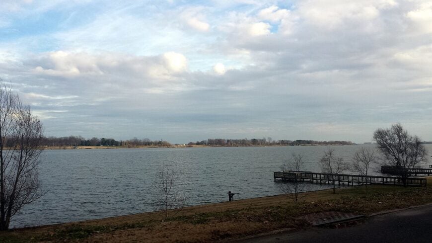
Southeast Arkansas is dotted with tiny places where time seems to idle and the nearest traffic light might be twenty miles away. These hamlets sit among bottomland hardwoods, bayous, and endless farm fields, offering deep quiet and a rare look at the state’s rural soul.
Our roundup counts down 25 of the most tucked-away spots in the region, each with its own story, hidden photo ops, and stretch-of-road solitude.
In order to come up with the very specific design ideas, we create most designs with the assistance of state-of-the-art AI interior design software.
From a ridge of pecan groves in Bradley County to century-old storefronts that haven’t heard a cash register ring in decades, the towns below invite day-trippers and relocation dreamers alike.
Bring a full tank of gas, a sense of curiosity, and maybe a cooler for roadside produce. Cell service fades fast out here, but that is half the reward.
25. Coleman

Coleman feels less like a town and more like a pause between fields, where the land dips into swampy stillness and cypress knees crowd the ditches. Fewer than 100 people call it home, most living in modest houses under heavy shade.
There’s no central square, no flashing sign to mark your arrival—just the sound of frogs and the occasional boat trailer heading to nearby Cut-Off Creek. Old fish camps, overgrown cemeteries, and a sense of slowness define this forgotten bend in the map.
Anglers launch canoes at sunrise, heron watchers peer through fog, and history buffs visit long-abandoned shanties said to be sharecropper quarters. Life here revolves around timber, trapping, and time that rarely moves in a straight line.
Where is Coleman?

Coleman is tucked into Chicot County, about ten miles west of Lake Village off Highway 144. The journey winds through soybean flats and over narrow levee bridges that hint at the river’s nearby reach.
It’s easy to miss—no gas stations, no town sign—but those who know how to follow the creeks find it, wrapped in silence and tall grass.
24. Ladelle

Ladelle exists at the edge of memory, hidden in a pine labyrinth where former logging roads now serve as the only way in or out. Most maps don’t even bother to mark it anymore.
The air carries a pitchy sweetness, and the scent of chainsaw oil lingers near a few weathered cabins. You won’t find commerce here—just rows of pine trunks and echoes of trains that no longer run.
Locals hunt deer, tend small gardens, and gather for fish fries at the firehouse. A few trailers and a church sign mark the heart of Ladelle, though even that’s softened by time and forest.
Where is Ladelle?

Ladelle lies in Drew County, about 12 miles south of Monticello via winding County Road 26. The paved road turns to gravel just before the town appears, hemmed in by logging tracts and thickets of loblolly pine.
Travelers usually pass it by, missing the quiet cluster hidden beneath the trees—just the way its residents like it.
23. Pickens

Pickens looks more like a plantation memory than a town, centered around a historic cotton office, a church, and a scattering of homes beneath arching trees. The population hovers near 100, most tied to the land in some way.
The town’s name appears on old railroad maps and Delta history books, but day-to-day life is slower now—marked by porch visits and the hum of irrigation rigs. Streetlights are rare, and nights arrive with deep, enveloping darkness.
Guests visit the century-old Pickens House or wander dirt roads past abandoned sheds and silent rail sidings. Agriculture remains king here—cotton, soybeans, and rice, with rhythms as old as the fields themselves.
Where is Pickens?

Pickens rests in Desha County, just east of Dumas, down a spur off Highway 65. You’ll drive past fields for miles before a small sign and a historic church steeple signal your arrival.
The community is surrounded on three sides by open farmland and bordered on the fourth by old levees, giving it a cloistered, agrarian stillness.
22. Florence

Florence lingers quietly on the edge of the Arkansas River, where empty grain silos and old barns stand watch over shifting soil. The town seems to exhale stillness, its unpaved streets lined with pecan trees and porch swings that never move.
Time trickles here like river current—slow, brown, and stubborn. No stoplights, no corner store, just the occasional passing pickup and the calls of barred owls at dusk.
What makes Florence feel so remote isn’t distance, but how completely it’s surrendered to the hush.
Where is Florence?

Florence is tucked into Phillips County just west of Helena‑West Helena, about 15 miles east of Monticello, near the river bottoms. You’ll follow Highway 138 until pavement yields to gravel, then ease through lowlands where the river decides who stays dry.
The levees, winding bayous, and the town’s position beyond any major traffic route give it a sense of being held apart from the rest of the world.
21. Selma

Selma’s wide lawns and old Victorian homes speak of a more prosperous past, but these days it’s a place defined by its peace and enduring stillness. The town once had a school and several stores; now, only mailboxes hint at where neighbors live.
Most homes are set back from the road, framed by pecan trees and aging barns. A clapboard church still holds monthly services, and the cemetery out back is lined with wrought iron and camellias.
Travelers may visit for the antebellum architecture or the calm walks along gravel shoulders. Farming, forestry, and faith sustain Selma’s heartbeat.
Where is Selma?

Selma sits along Arkansas Highway 81, about 15 miles northwest of Dumas in Drew County. It lies between fields and pine forest, removed from interstates and tucked into the weave of farm routes.
Reaching it involves slow turns through shaded roads—just enough to shake off the speed of the world.
20. Montrose

Montrose is the kind of town where time seems to wait politely at the edge of town. Just over 300 people live there, most in tidy homes on broad streets lined with crape myrtles.
The general store has long since closed, but the shell remains—red brick and faded signage hinting at livelier days. These days, conversation happens at the post office or out near the grain silos.
Visitors come through for the Delta heritage festival or the backroads beauty of a town wrapped in farmland and framed by sky.
Where is Montrose?

Montrose is located in Ashley County along Highway 165, between Wilmot and Portland. The main road runs straight through, but blink and you’ll miss the storefronts tucked beneath the shade trees.
Its quiet owes much to the levees that cut it off from heavy traffic, and the miles of rice and soy stretching out in every direction.
19. Glendale

🔥 Would you like to save this?
Glendale isn’t marked by stoplights or stores, but by the rhythm of life between pine trunks and gravel shoulders. It’s a working-class hamlet known for sawmills, pulpwood trucks, and thick clouds of wood smoke in the fall.
Homes are modest, many built by hand or passed down through generations. The community shows up for football games and church suppers, but otherwise keeps to itself.
Guests might visit for hunting season, or to hike the quiet trails along Saline River’s edge, where otters and deer leave prints in the clay.
Where is Glendale?

Glendale lies in Lincoln County on Highway 81, about 25 miles south of Pine Bluff. The drive in winds through managed forests and dips into hollows where fog lingers well past sunrise.
Its hidden nature stems from both geography and habit—it’s simply not built for outsiders, and that’s part of its charm.
18. Empire

Empire may be one of the least-known names on the map, but its roots go back to steamboat landings and lumber booms. Today, it’s a patchwork of farmhouses, bayou bends, and deep-woods solitude.
The air smells of damp leaves and woodsmoke, and the occasional deer stand breaks the endless green. A single store once served the area, but now it’s all self-reliance and strong backroads ties.
Those who pass through often do so by mistake—but they leave with images of oak canopies, white herons, and fields that seem to breathe.
Where is Empire?

Empire rests in northern Chicot County, between Dermott and the river bottomlands. It’s reachable only by winding county roads that change names mid-journey and follow no true grid.
Its removed feel is reinforced by the lack of signage, no cell towers, and the close press of trees that keep the rest of the world out.
17. Yellow Bayou

Yellow Bayou hums with stillness, its rhythm set by frogs, dragonflies, and the wind in the reeds. The houses here hide behind water oaks and willows, raised just high enough to outrun the spring floods.
Even locals speak softly, as though the bayou itself is listening. Boats outnumber cars, and conversations happen at bait shops or along levee trails.
It’s not just that Yellow Bayou is remote—it’s that it’s wrapped in wetland silence so complete, you forget the rest of the world exists.
Where is Yellow Bayou?

Yellow Bayou lies near the border of Desha and Chicot counties, just southeast of McGehee along an unmarked gravel road. It hides in the crook of old levees and sloughs, reachable only by those willing to follow the backwater.
With dense bottomland forest on one side and endless rice on the other, Yellow Bayou sits in a pocket where isolation feels both natural and absolute.
16. McArthur

McArthur is small even by Southeast Arkansas standards—just a dot among cotton rows and catfish ponds. It once had a schoolhouse and a cotton gin; now it’s mostly homes spaced far apart, connected by gravel and memory.
The town has no center, only a bend in the road where folks wave from porches and dogs nap in driveways. The old McArthur Baptist Church still rings its bell on Sundays, calling the faithful across long fields.
Farming and quiet faith anchor the community, and the sunsets stretch wide across the flat earth, uninterrupted by skyline or sound.
Where is McArthur?

McArthur lies in Desha County, about 10 miles southeast of Dumas off Highway 1. The turnoff is unmarked, and the roads narrow quickly—lined with ditches, bean fields, and endless sky.
The surrounding wetlands and levee trails keep it gently hemmed in, far from tourist routes or commerce of any kind.
15. Milo

Milo is little more than a whisper in western Ashley County—an old sawmill town where echoes remain in rusted machinery and half-sunken sheds. The forest has reclaimed most of it, but a few families still call it home.
At night, owls call from the pine tops, and during the day, the only hum comes from distant tractors or the breeze. No stores, no traffic, just the green hush of time passing.
Hikers and birders find joy in nearby Clear Creek Bayou, while locals keep the cemetery tidy and the memories alive.
Where is Milo?

Milo is located about 15 miles northwest of Crossett, along County Road 12. You reach it through a series of forest roads that narrow and darken with each turn.
The heavy woods and lack of any real throughway make Milo feel like a world apart—half memory, half moss-covered dream.
14. Longview

Longview stretches gently across the upper edge of Ashley County, its homes scattered between pine rows and bottomland creeks. There’s no town square, just a volunteer fire station and a hand-painted sign nailed to a pine tree.
Its sense of seclusion comes from the sheer density of forest in every direction. Pulpwood trucks are more common than cars, and trails here end not in destinations, but in silence.
Locals fish Clear Lake, tend small gardens, or cut timber during cooler months. The town may not host events, but its peace is its offering—thick, green, and humming with life just beneath the surface.
Where is Longview?

Longview is tucked along Highway 133 about 10 miles north of Crossett in western Ashley County. The drive weaves through second-growth timber and creek beds, with the canopy growing tighter the further you go.
There are few markers, and fewer distractions—just slow miles and soft curves that lull the outside world away.
13. Thebes

🔥 Would you like to save this?
Thebes is a near-forgotten crossroad deep in Cleveland County, where tall grasses swallow mailboxes and deer trails lead more places than paved roads do. Old homesteads sleep beneath sycamore limbs, and rusted farm gates swing in the breeze with no one to notice.
The sound of tires on gravel is rare, and even rarer is conversation outside the weekly church meeting or school bus run. The town has no center, just a loose scattering of lives stitched together by long memory.
Its seclusion is not dramatic but quiet—a slow disappearance into the woods and soil that shaped it.
Where is Thebes?

Thebes sits along County Road 84, roughly halfway between Rison and Herbine in north-central Cleveland County. With no signage and barely a presence on GPS, it lives hidden in the folds between pine forest and bottomland pasture.
Surrounded by paper-company tracts and lacking through-traffic, Thebes drifts beneath notice—a place you pass only if you meant to get lost.
12. Rye

Rye is a pocket of pine country known mostly to hunters, loggers, and those who once rode the Rock Island rail line through Cleveland County. With just a few dozen residents, it’s more a place of memory than motion.
Old churches, an aging schoolhouse, and a scattering of homes keep its heart beating. The community gathers for Sunday potlucks, shares deer jerky in fall, and marks time by seasons, not calendars.
Guests might spot wild turkeys along the road, hike into the pine breaks, or trace the old railway grade now swallowed by forest. Logging is still the main livelihood—trees come and go, but Rye remains.
Where is Rye?

Rye lies just off Highway 63, about 10 miles south of Rison and west of the Saline River bottoms. It’s reached by looping county roads that snake through forests thick with underbrush.
Its distance from towns and lack of modern development preserve a kind of hush—where even the gravel crunch beneath your tires seems reluctant to disturb the quiet.
11. Randall

Randall is little more than a bend in the road where pine woods open briefly to sky and then close again just as fast. The old store hasn’t sold gas in years, but its canopy still stands like a monument to the days when passersby were more common.
A handful of homes sit back from the road, shaded by chinaberry and cedar, their yards marked by clotheslines, tractors, and silence. Even the dogs here seem to bark softer.
Randall doesn’t hide out of shyness—it simply never needed to be found.
Where is Randall?

Randall lies in western Drew County, about 10 miles northwest of Monticello along Arkansas Highway 35. The highway narrows to two lanes and forgets to bring cell service, curving through pine cuts and past fields that vanish into brush.
Hemmed in by timberland and far from interstates, Randall feels like a page left unturned on purpose—a dot you only see when you’re going nowhere fast.
10. Hilo

Hilo claims roughly 80 residents scattered across breezy hilltops south of Warren. Locals tend cattle, harvest pecans, and swap stories at the volunteer fire station that doubles as a community hall.
Weekend visitors enjoy horseback rides along unmarked trails, freshwater fishing in Cane Creek, and bird-watching for the red-cockaded woodpecker that nests in nearby longleaf pines.
Small cow-calf operations and seasonal nut processing keep a modest economy turning, yet there is no retail strip, fast food sign, or steady traffic to break the stillness.
Dense tree lines and rolling ravines buffer homesteads from one another, so sunset feels like it belongs to a single porch swing. This natural screening, plus the absence of through-highways, makes Hilo feel a world apart.
Where is Hilo?

Hilo sits on a rise along Arkansas Highway 278, about eleven miles west of Warren and thirty miles north of the Louisiana border. Thick forest on three sides and a lattice of gravel roads limit casual pass-throughs.
Travelers usually reach it by turning south off the highway onto County Road 31, then following a series of unsigned curves that confound GPS. The result is a pocket of farm country where the loudest sound might be wind in the pecan trees.
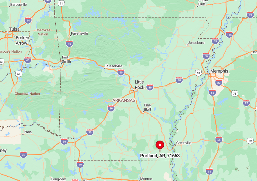
9. Portland

Home to just over 400 people, Portland once buzzed with cotton wealth but now dozes under sprawling live oaks veiled in Spanish moss. Photographers love the abandoned brick mercantile row, especially during golden hour when light pours through empty window frames.
A few family pecan orchards and row-crop farms still operate, and duck hunters rent spare rooms each winter to reach prime flooded timber nearby. Commerce hums quietly at the co-op gin, yet vacant avenues wider than some four-lane highways hint at bygone boom times.
The low resident count and expansive streets mean neighbors feel blocks away even in town center. Surrounded by unbroken farmland and levee cuts, Portland stays untroubled by crowds.
Where is Portland?
🔥 Would you like to save this?
Portland lies on U.S. 165 in Ashley County, twenty miles north of the Louisiana state line and fifteen miles south of Lake Village. Bayous, levees, and broad fields isolate the grid from larger towns; drivers on the highway often miss the turn onto Main because the storefronts blend into the trees.
The nearest interstate entrance is over an hour away, trimming tourist traffic to a trickle. Visitors usually arrive by scenic Highway 160, a route that offers mile after mile of pecan groves and heron-filled sloughs.
8. Kingsland

With an estimated 400 residents, Kingsland proudly celebrates its link to music legend Johnny Cash while preserving a hush that belies such fame. Travelers stop at the modest birthplace marker, then explore shade-covered streets where wood-frame homes sit far back from the road behind thick swaths of pine and oak.
Small-scale logging and a boutique sawmill supply most local paychecks, and a weekend bluegrass jam at the community center draws pickers from three counties. Outdoor lovers wander the Saline River bottoms nearby, searching for mussel shells and rare wild orchids.
Thick forest walls absorb road noise and screen even the post office from view, so the town feels hidden even when standing in its heart. The lack of retail chains or regional highways ensures the quiet remains intact.
Where is Kingsland?
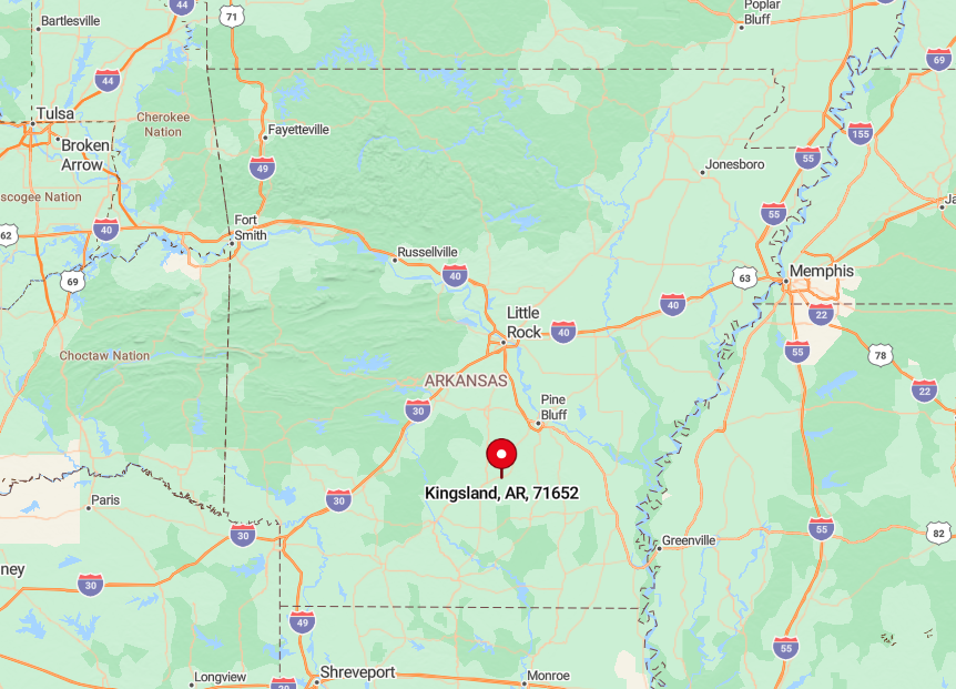
Kingsland occupies a bend of Arkansas Highway 189 in Cleveland County, roughly thirty miles north of Monticello. Reaching it means threading two-lane roads that weave through pulpwood tracts and creek bottoms with spotty cell coverage.
Passing freight trains provide the only heavy rumble, and they roll through just a few times a day. For most visitors the easiest path is via Highway 79 to Fordyce, then west on 189 until the woods suddenly part to reveal a small green city-limit sign.
7. Tillar

Tillar’s population hovers near 200, and most of those residents can hear grain being augered into the towering concrete silos that anchor town. Activity centers on row-crop agriculture; soybeans and rice funnel through the elevator, filling the air with the scent of fresh chaff each harvest.
A restored 1913 depot displays railroad memorabilia and hosts an annual fish fry that doubles as the social event of the year. Birders slip down ridge-top farm roads to spot kestrels perched on power lines, while cyclists appreciate the near absence of vehicles.
Vast fields flatten sound and sightlines, so each house seems set against an ocean of green in summer and gold in fall. With only one stop sign and several dirt streets, Tillar registers hardly any motion after dusk.
Where is Tillar?
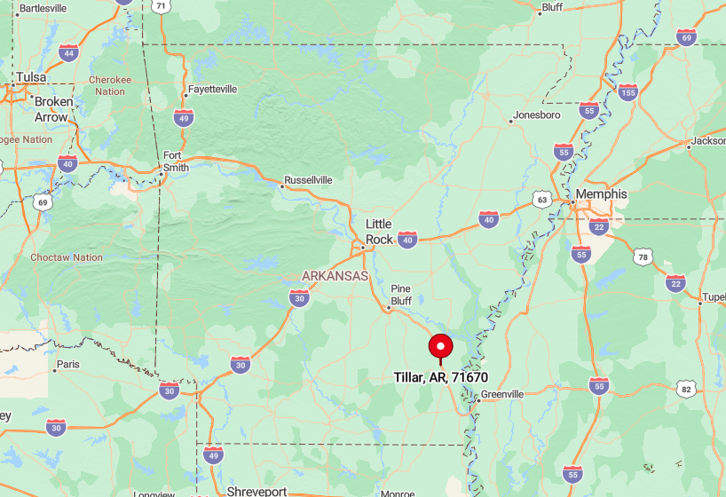
Tillar straddles the Drew–Desha county line along U.S. 65/165 but hides just east of the highway on a spur that most drivers skip. The nearest full grocery store is fifteen miles away in McGehee, underscoring the town’s detachment.
Access comes via a short, unsigned loop road that swings under an abandoned rail spur before reaching Main Street. The surrounding levee maze, coupled with limited signage, deters casual exploration and shelters the quiet.
6. Jerome

Fewer than 30 people reside in Jerome, a place once crowded with 8,000 Japanese American internees during World War II. Today the landscape features a handful of post-war cottages, concrete slab remnants of barracks, and rice fields stretching to every horizon.
Agriculture—rice, soybeans, and crawfish—supports a couple of farm families, while heritage tourists occasionally stop to read the interpretive sign about the camp. The old water tower and chimney foundations stand as silent sentinels, making sunset here feel particularly haunting.
With no stores, no school, and minimal traffic, evenings settle into profound stillness broken only by frogs in roadside ditches. The sheer openness and historic emptiness underscore Jerome’s seclusion.
Where is Jerome?
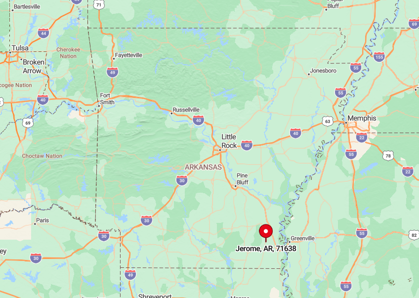
Jerome sits on U.S. 165, twenty miles southeast of Star City and nearly equidistant from Pine Bluff and Lake Village yet close to neither. Tall rice levees block sightlines from the highway, so blink and the town is gone.
Visitors exit onto a short frontage road that dead-ends at the camp marker; beyond that, gravel section lines lead only to farm shops. Lack of services ensures few linger, leaving the crossroads eerily quiet year-round.
5. Wilmot

About 450 people call Wilmot home, though many live on rural routes rather than inside the sparse town grid. Cracked sidewalks and the brick shell of a 1920s cotton gin hint at the Delta wealth that once flowed through here.
Modern livelihoods revolve around catfish ponds, cotton modules, and seasonal duck-hunting guides who work flooded millet fields nearby. Antique pickers favor the abandoned Masonic hall, where century-old tin ceilings still gleam under dust.
The Arkansas River levee to the west and the Mississippi backwater levees eastward form clay walls that cocoon the settlement. Wide spacing between homes, plus vacant commercial blocks, helps Wilmot keep its whisper-level ambiance.
Where is Wilmot?

Wilmot sits along Highway 165 in south-central Ashley County, thirteen miles north of the Louisiana line. Travelers usually reach it via the Great River Road National Scenic Byway, a route that hugs levees and wetlands far from interstates.
Sparse fuel stops and lengthy stretches without habitation emphasize the town’s isolation long before its water tower appears. Once inside, visitors notice that most side streets simply fade into gravel tracks leading to cotton fields.
4. Watson

Watson’s headcount sits near 200, clustered on a slight rise that stays dry when the White River jumps its banks. Anglers and paddlers launch from the nearby Arkansas River access to explore cypress brakes within the expansive White River National Wildlife Refuge.
Local work centers on row-crop farming, with guiding services for duck and deer hunts adding winter income. A single café in a converted house serves catfish plates on Fridays and doubles as the community’s unofficial news desk.
Levee roads run arrow-straight for miles with no crossroads, giving a sense of drifting across a watery prairie. That endless wetland view, plus the absence of commercial noise, seals Watson’s seclusion.
Where is Watson?
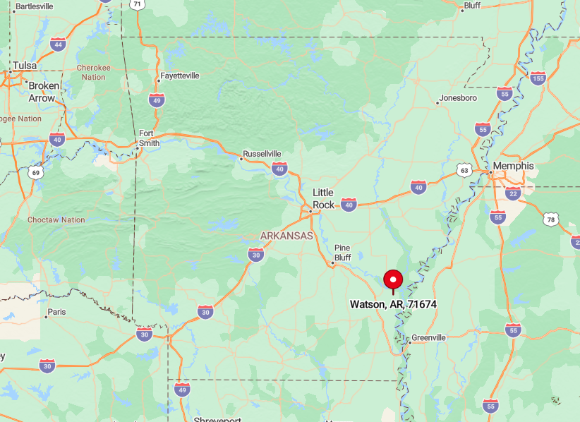
The village stands at the junction of Highways 1 and 4, thirty minutes south of DeWitt and an hour north of Dumas. Dense bottomland forest to the east and vast rice acreage to the west limit development and muffle sound.
Visitors typically arrive via Highway 1, crossing broad oxbow lakes and occasional towboat canals before reaching the elevated cluster of homes. Once there, only a couple of gravel spurs break away from the main drag, and most end at locked refuge gates.
3. Banks

Banks supports around 120 residents and exactly one stop sign at the heart of its T-shaped main road. The restored 1906 depot, painted bright red, hosts the annual Buck Fever Festival celebrating deer season’s opening weekend with stew contests and bluegrass tunes.
Small poultry farms and logging crews working second-growth pine provide most employment, while the rest commute to Warren or Fordyce. Hikers explore remnants of the old Chicago, Rock Island & Pacific rail grade that slips into loblolly stands teeming with wild muscadines.
Limited cell coverage, minimal street lighting, and miles of timber on every side wrap Banks in dusk even before the sun sets. Such isolation keeps traffic counts so low that locals wave at every headlight by reflex.
Where is Banks?
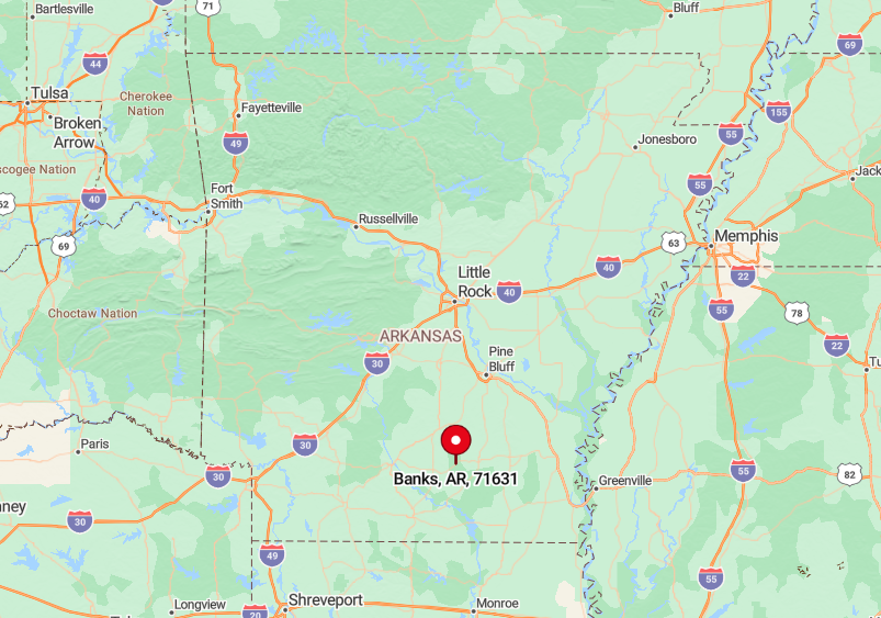
The town rests along U.S. 278 in northern Bradley County, but dense forest hides it from sight until the depot appears beside the highway. Only one paved side street, Banks Avenue, runs a quarter-mile before turning to gravel and vanishing among pines.
Travelers generally reach Banks after forty minutes of two-lane driving from either Camden or Monticello, the nearest cities of note. Once inside the loop, the road narrows, the woods close in, and night sounds take over.
2. Winchester

Winchester counts about 150 inhabitants, many living on five- to ten-acre homesteads carved from former cotton land. Daytime diversions are simple: casting for bream in Wildcat Bayou, rummaging for arrowheads along freshly plowed lines, or helping at the century-old Methodist church’s monthly fish fry.
A modest trucking yard and seasonal farm labor make up the local economy, but towering pine plantations on three sides dominate the acreage. These managed forests swallow road noise, creating pockets where the loudest sound is wind through pine needles.
Scattered farmhouses sit out of sight from the road, adding to the impression of emptiness. Streetlights are rare, making stargazing a favored evening pastime.
Where is Winchester?

Perched on U.S. 65 in northeast Drew County, Winchester is fifteen miles north of McGehee and surrounded by 100,000 acres of timber leased to paper companies. Only two paved roads enter town, both cutting straight through pines before dead-ending at bean fields.
Most visitors arrive from Little Rock by exiting I-530 at Dumas, then following the highway south past endless loblolly stands. The final miles reveal little besides log trucks until a small blue DOT sign announces the hamlet.
1. Parkdale

Parkdale, population roughly 175, looks much as it did in 1920: broad, oak-shaded avenues, ornate brick façades with iron awnings, and ghost signs advertising flour and feed.
Travelers photograph the long-silent Bank of Parkdale building and peek into the boarded McCloy Mercantile, whose maple floors still gleam beneath the dust. Soybean and corn fields that roll unbroken for miles provide most livelihoods, complemented by a boutique heirloom-rice farm shipping nationwide.
Bird-watchers stake out the nearby Cut-Off Creek WMA for swallow-tailed kites, and antique hunters sometimes score Depression-era glassware at pop-up estate sales.
Because many storefronts are shuttered and homes sit deep on tree-lined lots, the grid feels abandoned even at midday. The flat Delta surroundings amplify quiet, so footsteps on Main Street echo like drumbeats.
Where is Parkdale?
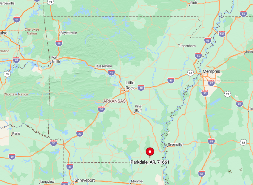
Parkdale sits on Arkansas Highway 8 in western Ashley County, twenty-five miles southeast of Crossett and forty miles from any major four-lane. Reaching it involves low-speed drives along levee tops that trace the Boeuf River, with only crop dusters for company.
The nearest gas station is eight miles away in Hamburg, reinforcing the sense of disconnection. Those who navigate the last straight mile under a cathedral of live oaks discover a town preserved in deep, deliberate stillness.


