🔥 Would you like to save this?
The quiet corners of Northwest Arkansas still harbor hamlets where porch lights are few, night skies glitter, and rush hour means waiting for a herd of deer to cross a gravel lane.
Our team mapped 25 of these out-of-the-way communities, each wrapped in forest, bluffs, or pasture that naturally limits growth and noise. Visitors find trout streams instead of traffic, historic general stores instead of chain restaurants, and neighbors who wave because they probably know everyone for miles.
In order to come up with the very specific design ideas, we create most designs with the assistance of state-of-the-art AI interior design software. Also, assume links that take you off the site are affiliate links such as links to Amazon. this means we may earn a commission if you buy something.
Although Bentonville and Fayetteville expand by the year, the Ozarks absorb sound and light, leaving pockets of deep calm just over the next ridge. These towns prove a person can remain close enough for groceries yet far enough for true stillness. Here are 25 places where seclusion is part of the address.
25. Winslow

Winslow is a misty mountain town perched along a ridge in the Boston Mountains, where fog gathers like an old friend each morning. With fewer than 400 residents, it holds a certain hush that never quite leaves, even when the wind rustles the treetops.
The town’s seclusion stems from its elevation and the winding switchbacks of U.S. Route 71 that crest just above it. Most travelers speed past in the nearby tunnel, unaware of the sleepy town nestled above.
Winslow exudes rustic charm, with hiking access to Ozark National Forest, historic buildings from its days as a railroad stop, and small-town celebrations like the Old Time Christmas Parade. Locals often work in surrounding areas or live quietly on forested homesteads.
Where is Winslow?

Winslow lies at the southern tip of Washington County, about 35 miles south of Fayetteville. It hugs the high ridgeline above the Bobby Hopper Tunnel along old Highway 71.
You’ll reach it by leaving the interstate and winding up the mountain through dense hardwoods and switchbacks. Its altitude and lack of direct highway access help keep the modern world at bay.
24. Rudy

Rudy is a quiet settlement tucked into the rolling green hills near the Oklahoma line. With fewer than 100 residents, it offers a peaceful existence surrounded by pastures, low ridges, and mist-covered valleys.
Its hidden nature comes from being bypassed by nearby I-49, leaving it nestled along county roads that trace the original north-south route.
Life here revolves around farms, family gatherings, and quiet nights. Visit local farmstands, fish in ponds, or explore old barns that have stood for generations. Many residents are retirees or commute to Van Buren for work.
Where is Rudy?

Rudy sits in northern Crawford County, just west of I-49 and about 15 miles north of Van Buren.
To get there, you exit the highway and follow county roads through a patchwork of farmland and hills. Though the interstate hums nearby, Rudy remains a tucked-away world of its own.
23. Forum

Forum is less a town than a place you stumble upon—perched on the shoulder of the Ozarks, framed by bluffs and wooded creeks. There’s no real town center, just homesteads, a few mailboxes, and the winding road that connects them.
Its isolation is due to topography and legacy—Forum was once a hub for local timber workers, now it’s a whisper along Arkansas Highway 23.
Nearby, you’ll find Withrow Springs State Park for hiking and swimming, scenic overlooks of War Eagle Creek, and old cemeteries half-swallowed by moss. It’s a place where time fades, and quiet takes hold.
Where is Forum?

Forum lies in northeastern Madison County, east of Huntsville, just off Highway 23.
Getting there means navigating curving ridges and creek valleys that seem to forget which way is straight. The drive itself adds to the dreamlike sense of being far removed.
22. Watalula

Watalula clings to the edge of a ridge near the Ozark Highlands Trail, a small scattering of homes overlooking valleys that stretch for miles in every direction. The air feels thinner up here, and the sky stretches wider than you might expect.
Its deep sense of seclusion stems from being hemmed in by national forest on multiple sides, with nearby traffic from Altus never quite making it over the hill.
Expect quiet country churches, peaceful ridgeline views, and easy access to trailheads and waterfalls that feel like they belong to just you. Residents raise cattle, tend gardens, or lend their skills to guiding the occasional hiker or river floater who passes through.
Where is Watalula?

Located in northern Franklin County, Watalula is perched high along Arkansas Highway 23 between Cass and Ozark.
The route winds upward in slow, scenic curves, with few markers and even fewer businesses, giving travelers the sense that they’ve entered a mountain enclave where time moves at a gentler pace.
21. Sulphur Springs

Sulphur Springs is a quiet borderland village with a cool, spring-fed lake and faint echoes of a grander past. Once famous for its mineral waters, the town now floats gently along the Arkansas-Missouri line with a population of just a few hundred.
The town’s tucked-away feeling comes from being set apart from main highways, pressed between a series of wooded ridges and the edge of the state.
Stroll the lakeside trail, visit the historic bathhouse, or spread a picnic blanket in the quiet city park while the breeze carries stories from another century. Many residents retire here, while others commute to Gravette and return to the silence.
Where is Sulphur Springs?

Sulphur Springs rests in the far northwest corner of Benton County, only minutes from the Missouri state line.
It’s accessed by a winding network of county roads branching off U.S. Route 59, with each bend leading you farther away from the modern rush and deeper into the soft hills.
20. Saint Paul

Saint Paul feels like a tiny frontier settlement caught gently between eras, hidden by forested peaks and wrapped in deep valleys. Its population barely tops 150, and its downtown is a sleepy row of weathered facades that echo the early 20th century.
This town’s remoteness comes from its placement at the very edge of the Ozark National Forest, where roads climb steeply and descend just as quickly through rugged, wooded terrain.
Visitors often find themselves hiking White Rock Mountain, casting a line into the White River, or browsing goods at a creaky old general store where the clerk knows everyone by name. Most residents make a living from farming or forest-related trades.
Where is Saint Paul?

Saint Paul lies deep in southeastern Madison County, nestled along Highway 16 about 25 miles east of Huntsville.
Reaching it requires a long, slow climb through dense woodland and steep ravines that seem to bend away from civilization, creating a sense of having slipped into a quieter pocket of time.
19. Ozone

🔥 Would you like to save this?
Ozone is a sky-high crossroads where the clouds dip close enough to brush the treetops, and fewer than 200 people call it home. From this perch, sweeping views of the Ozark Mountains unfold in every direction, and silence often outweighs sound.
The name says it all: perched at nearly 2,000 feet, the town stands quite literally above it all, its elevation lending it both breathtaking vistas and a strong sense of remove.
Travelers often stop to hike along forest trails, take in the views from roadside overlooks, or grab a bite at the legendary Ozone Burger Barn. It’s also a favorite waypoint for motorcyclists riding the twisting length of the Pig Trail Scenic Byway.
Where is Ozone?

Ozone is situated in northern Johnson County along Arkansas Highway 21, about 18 miles north of Clarksville.
The road that leads there cuts through thick stands of oak and pine, twisting upward in switchbacks that open to sudden overlooks, making it clear this isn’t a place you pass through by accident—you come because you know.
18. Boston

Boston is a forgotten dot on the map where the road narrows, the trees grow taller, and the wind through the leaves feels older than memory. Once a stop on the Butterfield Overland Mail route, it now lingers quietly in the hills, marked more by wildflowers and stone foundations than by anything modern.
Its deep seclusion comes from the surrounding Ozark National Forest, which wraps the area in ridges, hollows, and unpaved roads that vanish into the trees. No shops, no signs—just silence and scattered traces of old lives lived.
Hike the Ozark Highlands Trail, sleep beneath oak canopies, or stand still long enough to hear the land breathe. Boston isn’t just off the beaten path—it’s beyond it.
Where is Boston?

Boston lies in northern Madison County, tucked between Red Star and Oark in a quiet fold of national forest.
To get there, you follow gravel roads that wind through dense woodland, leading to a place where even time seems content to pause.
17. Canehill

Canehill is a place where history clings to the hillsides and art grows in the shadows of 19th-century brick buildings. Once the home of Arkansas’s second-oldest college, this town of a few hundred people feels suspended in time, held together by porches, stone walls, and the stories passed from neighbor to neighbor.
Its sense of seclusion comes from being tucked off the main highways, surrounded by quiet hills and reached by roads that meander as if they, too, are reluctant to leave.
Visitors can tour restored historic homes, hike the wooded paths near Jordan Creek, or wander through the town’s art exhibitions housed in lovingly preserved buildings. Life here is anchored by local craftspeople, farmers, and educators who value quiet beauty and deep roots.
Where is Canehill?

Canehill is nestled in the far southwestern corner of Washington County, close to the Oklahoma border and a few miles west of Lincoln.
Although it sits just off Highway 62, the main road dips away and leaves Canehill to bask in its own quiet, tucked between low hills and surrounded by timeworn trees that seem to protect it from modern noise.
16. Evansville

Evansville lies at the end of a road and the edge of the state, where cattle roam across open pastures and front porches face a horizon unbroken by cities or crowds. With only a handful of homes, it feels more like a wide breath of wind than a town, a place where time rests easy and the land speaks louder than any clock.
Its deeply rural setting, pinned between ridges and borders, makes it one of the most remote-feeling communities in Northwest Arkansas.
Here, people spend their days tending livestock, hunting, and savoring the silence that stretches across fields. You might stop at the tiny post office or follow a gravel track to a hidden creek—but chances are, you’ll be the only one there.
Where is Evansville?

Evansville is located in western Washington County, just a mile from Oklahoma and not far from the Missouri state line, deep in the borderlands.
Reaching it means rolling over country roads where the trees arch above and fields open out on either side, with no commercial traffic and no reason to rush—just space, sky, and quiet.
15. Strickler

Strickler is the kind of place that flickers into view and then disappears again behind the trees, a gentle pause in the landscape rather than a destination. It’s more of a whisper among the pines than a town, made up of scattered homes, old mailboxes, and fields where deer gather at dusk.
Its near invisibility comes from its absence of shops, signs, or traffic—just winding roads that lead you past it without ever quite announcing it was there.
You can fish in the creeks nearby, picnic at Devil’s Den State Park, or simply follow the curves of the road and feel your breath slow down. For many who live here, the appeal is just that: a life measured by seasons and sunrises.
Where is Strickler?

Strickler lies in southern Washington County, about 20 miles southwest of Fayetteville, tucked into the folds of the Boston Mountains.
The way in is a winding drive along tree-lined backroads that feel more like nature trails than thoroughfares, where each bend reminds you just how far you’ve come from city life.
14. Brentwood

Brentwood exists in the quiet space between places, cradled in a low valley just off the old highway, where fields stretch out on either side and houses peek from behind groves of trees. It’s the kind of place that’s easy to miss but hard to forget once you’ve felt the way the stillness settles there.
It feels secluded not because it’s far, but because it’s forgotten—overshadowed by the faster pace of neighboring towns and bypassed by modern roads.
You might spend time walking its quiet lanes, visiting nearby produce stands in summer, or watching the clouds roll over green hills that haven’t changed much in generations. Most people here farm or commute quietly from a town that prefers not to raise its voice.
Where is Brentwood?

Brentwood rests in central Washington County, just south of Greenland along the old route of U.S. Highway 71.
Though close to the buzz of Fayetteville, its position in a narrow wooded valley keeps it feeling cloistered and calm, as though the world forgot to speed up when it passed this way.
13. Morrow

🔥 Would you like to save this?
Morrow is the kind of countryside crossroads where church bells still echo across hayfields and the silence at night is thick enough to hold. There’s no town center to speak of, just fences, barns, and the winding road that carries locals home.
Its isolation is the natural result of geography—a gentle web of hills and hollows that refuse to flatten out—and a road system that discourages haste.
Birdwatchers, stargazers, and those seeking complete disconnection will find peace here, along with a glimpse of rural Arkansas life untouched by time. Farming is the rhythm, and the land leads the way.
Where is Morrow?

Morrow is situated in southwestern Washington County, about 10 miles south of Lincoln and far from the paths most travelers take.
To reach it, you’ll travel over gravel and patchy pavement, through hollows and across ridges, until suddenly there’s nothing around but pastures and sky. The quiet feels earned.
12. Clyde

Clyde isn’t so much a town as a quiet moment along a bend in the road, where homesteads are spaced wide apart and the only sounds are wind, birdsong, and the distant bark of a farm dog. It feels as if the land itself is guarding its solitude.
Its remoteness is shaped by terrain and choice—a scattering of homes along ridges and valleys where phone service fades and roads follow the curve of the hills.
Locals garden, raise animals, or simply watch the seasons turn from deep porches. Those who pass through might not even realize they’ve found Clyde, which is just the way folks there like it.
Where is Clyde?

Clyde is nestled in the heart of Madison County, between the towns of Wesley and Red Star, surrounded by a thick weave of forest and field.
Reaching it means trusting narrow county roads that wind like creeks, with the occasional mailbox your only sign of settlement. It’s a place you find by feel more than by map.
11. Aurora

Aurora rests high on a ridgeline above the farmland and forest, a small collection of homes where the wind always seems to be whispering through the trees. With a population that doesn’t quite reach 100, it offers more space than sound and more sky than structure.
It’s hidden in plain sight along Highway 23, but the trees grow thick and the signs are few, giving it the feel of a place that has gently faded into the hills around it.
Visitors often find their way to nearby Withrow Springs State Park or follow the curves of scenic drives, but most who live here are drawn by the promise of peace and the pleasure of watching stars come out, undisturbed by city light.
Where is Aurora?

Aurora is located in northern Madison County, just a few miles north of Huntsville, but it might as well be worlds away.
Though it lies close to a state highway, its hilltop perch and the quiet rural sprawl around it lend the town a stillness that makes it feel timeless, held gently between the sky and the forest.
10. Ponca

Ponca claims a population of roughly 30 permanent residents who share the valley with a free-roaming herd of Rocky Mountain elk introduced in the 1980s.
Paddling the Buffalo National River, photographing elk at dawn in the fields behind the low-slung community center, and scrambling up the Goat Trail to Big Bluff rank among favorite activities.
Seasonal outfitters, a scattering of vacation cabins, and limited park service jobs form the backbone of local work. There is no cell reception in the valley, no grocery store, and towering limestone walls block most through roads, making Ponca feel many counties away from Fayetteville’s growth corridor.
Even summer crowds disappear after sunset, leaving only the chirp of tree frogs and the distant splash of the river against polished boulders. The hamlet’s handful of homes sit on multi-acre lots that blend almost seamlessly into public wilderness, preserving a sense of outright isolation.
Where is Ponca?
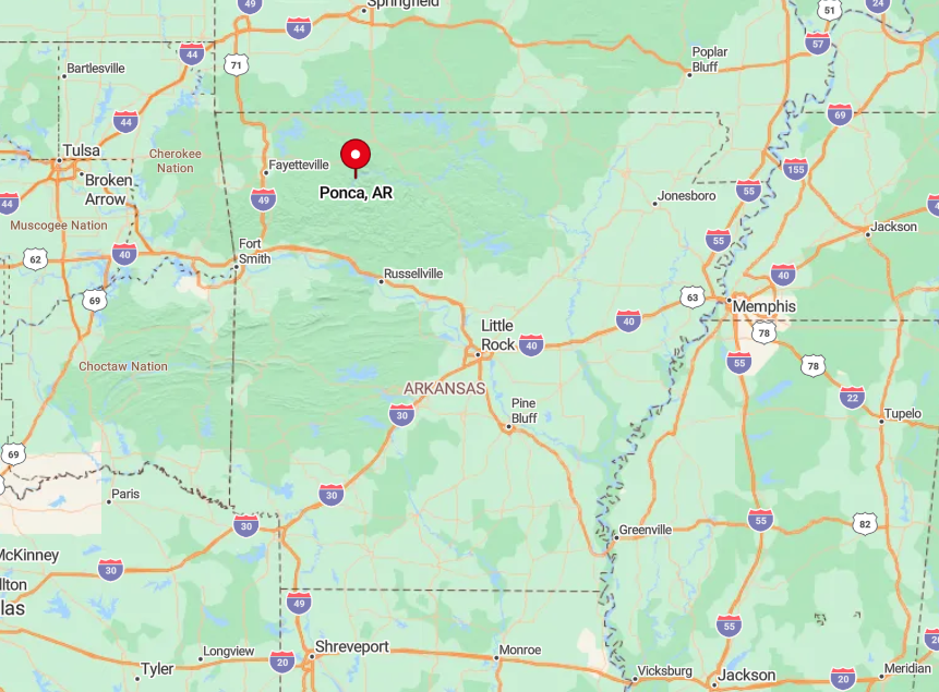
Ponca rests in Newton County near the midpoint of the Buffalo National River, about one hour southeast of Harrison. Steep bluff lines and federally protected riparian zones confine any potential expansion and shield the valley from highway glare.
Reaching town requires hairpin turns along Arkansas Highway 43, a route that narrows to one lane in places as it clings to the mountainside. Most travelers arrive by personal vehicle since no public transit ventures into this stretch of the Ozarks.
9. Kingston

Kingston counts just under 700 residents who center daily life on a courthouse square barely the size of a football field. Locals gather at the café for plate lunches, then drift out to fish War Eagle Creek or ride gravel bikes on the “Pig Trail” byway.
Cattle and poultry operations, small scale tourism, and the K-12 school provide steady if modest employment. The nearest four-lane highway lies more than twenty hilly miles away, with thick Ozark National Forest ridgelines buffering the town from outside bustle.
Downtown closes early, the sky fills with stars, and the only after-dark glow comes from porch bulbs and the co-op’s security light. Visitors often marvel that cell phones revert to roaming within minutes of leaving the square, underscoring how removed Kingston remains.
Where is Kingston?

🔥 Would you like to save this?
Positioned in eastern Madison County, Kingston sits at the junction of Arkansas Highways 21 and 74. Surrounded by rolling pasture and unbroken forest, the settlement feels tucked inside a natural amphitheater that mutes distant noise.
Drivers wind through switchbacks for half an hour from Huntsville or for nearly an hour from Fayetteville before the courthouse dome appears. With no bus routes and only occasional delivery trucks, personal vehicles are the sole reliable way in and out.
8. Compton

The plateau community of Compton supports roughly 300 inhabitants who live among century-old farmsteads, barns, and gums and maples that blaze red every October.
Hikers set off from town to Hemmed-In Hollow Falls, the tallest cataract between the Appalachians and Rockies, while birdwatchers listen for pileated woodpeckers in the deep ravines nearby.
Limited forestry work, vintage cabin rentals, and a family-run general store make up most local business. Compton’s elevation keeps winter roads icy and steep drop-offs discourage casual traffic, contributing to the feeling that the plateau floats above the modern world.
Houses sit on parcels ranging from five to one hundred acres, guaranteeing elbow room and quiet nights. For many residents, the loudest sound is the whistle of wind across open hayfields.
Where is Compton?

Compton perches on Highway 43 about twelve miles north of Ponca in northern Newton County. Sheer cliffs and dense hardwood forest border the road, with no side streets until the next township.
Spring floods sometimes close the low water bridges that serve as alternate routes, further isolating the area. Access relies on a single stretch of state highway that twists 1,200 vertical feet from valley floor to plateau.
7. Witter

Witter’s population hovers near 150, dispersed across a valley bottom stitched with hay meadows and spring-fed creeks. Anglers cast for smallmouth bass in nearby War Eagle Creek, while backroad explorers hunt wild morels each April on shaded north slopes.
Beef cattle, niche organic farms, and remote work sustained by satellite internet provide most income. Hills that rise abruptly on all sides block radio and cell signals, preserving a sense of being tucked inside a private bowl.
Nights stay remarkably dark, and the Milky Way regularly splashes across the open sky. Neighbors often gather at the century-old community center for pie suppers that double as the town’s social calendar.
Where is Witter?
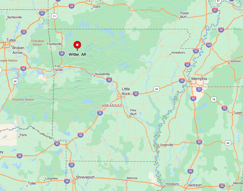
Located in southern Madison County, Witter lies forty minutes east of Springdale along Arkansas Highway 23. The so-called “Pig Trail” crosses razorback ridges and narrow valleys, making the drive scenic but slow.
National forest tracts bracket the valley, limiting development and commercial traffic. Travelers rely on private cars or motorcycles since no public transportation navigates these winding roads.
6. Oark

Oark shelters roughly 50 full-time residents whose social hub is the Oark General Store, in continuous operation since 1890. Canoeing the Mulberry River, exploring the High Bank Twin Falls, and riding dual-sport motorcycles on Forest Road 144 are popular pastimes.
Seasonal rafting guides, the café inside the store, and small cattle herds form the economic backbone. Surrounded by Ozark National Forest land, the town stays pitch dark after sunset and traffic often consists of a single pickup crunching gravel.
The community’s single-lane bridge and narrow approach roads deter large vehicles, reinforcing its quiet character. Local legend claims the fireflies seem brighter here because there is no other light to compete.
Where is Oark?
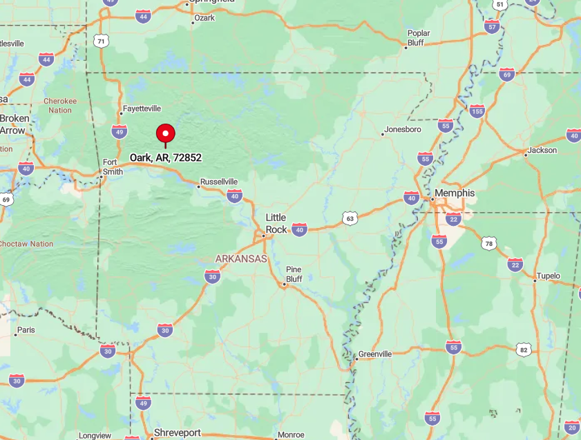
Oark nestles in Johnson County along Arkansas Highway 215, thirty miles northeast of Clarksville. The route follows the Mulberry River corridor, hemmed by steep forest that blocks cell towers and billboards alike.
Visitors must cross a weight-restricted bridge built in 1940, which keeps heavy trucks away. The absence of bus lines means the journey is strictly for those willing to navigate twisting pavement at their own pace.
5. Natural Dam

Natural Dam records a population just under 400, scattered along Lee Creek at the northern edge of the Boston Mountains. Families swim beneath the namesake sandstone waterfall, picnic under sycamores, and ride horses on forestry trails lacing the adjacent Ozark National Forest.
Limited forestry jobs, small cattle operations, and weekend tourism at the falls sustain livelihoods. The bypassed alignment of U.S. 59 swings wide of town, leaving the core area tucked along a county road with little through traffic.
Most homes sit on acre-plus lots bordered by mixed oak and pine, keeping neighbors hidden among the trees. Quiet evenings are punctuated only by the steady rush of water over the natural dam.
Where is Natural Dam?

The community lies in Crawford County about twenty minutes north of Van Buren, yet a bend in Lee Creek and thick forest hide it from the main highway. A short spur, Arkansas Highway 348, dead-ends at the waterfall, discouraging casual passersby.
Bluff lines and creek valleys confine development to narrow benches, maintaining the secluded atmosphere. Travel requires personal vehicles since no commercial shuttles serve this pocket of the Ozarks.
4. Lost Bridge Village

Lost Bridge Village houses approximately 450 residents who enjoy sweeping lake views from decks cantilevered over oak-covered slopes. Boating, scuba diving in submerged river channels, and winter eagle watching draw outdoor enthusiasts year round.
Construction trades tied to vacation home maintenance, a volunteer fire department, and a small marina employ many locals. The community spreads over a peninsula hemmed by coves, with roads so narrow and winding that GPS often suggests impossible U-turns, reinforcing the sense of remoteness.
Big-box shopping requires a 35-minute drive over two ridges and across Beaver Dam to Rogers. Even package delivery drivers must plan ahead, as cell service fades once vehicles dip below the ridge crest.
Where is Lost Bridge Village?
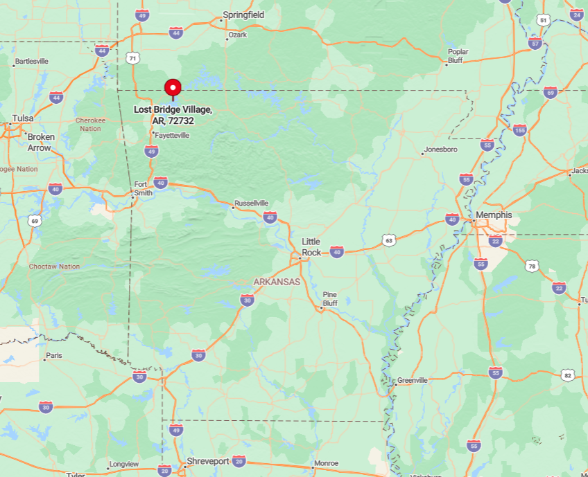
This enclave sits in eastern Benton County off Arkansas Highway 127, roughly fifteen miles east of Rogers by road yet psychologically much farther. Steep hollows plunge directly to the lake, confining access to one ridge-top entry road and a handful of switchbacks.
The water barrier on three sides and national recreation land on the fourth keep traffic light. Reaching the peninsula demands a private car; no transit loops around Beaver Lake.
3. Marble

Marble’s resident count sits near 280, strung like pearls along the Kings River and Arkansas Highway 23. Fly anglers stalk smallmouth in the clear runs below Kings River Falls, while travelers book vintage log cabins for stargazing and firefly season.
Pasture-raised beef, a sawmill specializing in white oak, and seasonal cabin rentals provide most income. Unbroken forest rises immediately behind riverside farms, blocking both cellular signals and future subdivisions.
With no streetlights, night birds and the thrum of the river fill the soundscape. Locals still meet at the defunct store’s porch for coffee and weather talk, keeping community ties strong.
Where is Marble?

Marble lies in southern Madison County, sixteen miles north of Huntsville along Highway 23. The roadway hugs the Kings River gorge, making passing zones rare and travel speeds slow.
National forest parcels bracket both sides of the highway, limiting development and preserving clear night skies. Visitors must rely on personal vehicles, and river fords occasionally close side roads during high water, adding to the town’s secluded feel.
2. Pettigrew

Pettigrew now supports about 90 residents, a far cry from its timber boomtown peak early last century. Hikers trek to Fane Creek’s mossy waterfalls, and history buffs explore the ruins of old railroad trestles swallowed by tulip poplars.
Limited forestry contracts, hobby farms, and remote telecommuting comprise the local economy. National forest tracts almost encircle the settlement, and winding county roads discourage hurried drivers, ensuring peace nearly every hour of the day.
Homes hide behind cedar hedges on five-plus acres, offering privacy even from fellow townsfolk. Owls and coyotes provide the only nocturnal soundtrack.
Where is Pettigrew?
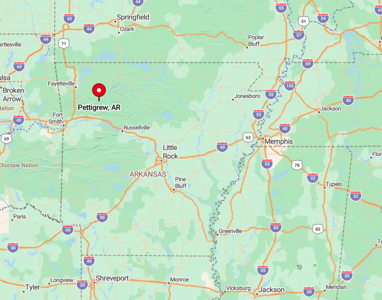
The hamlet sits in extreme southeast Madison County along County Road 3980, roughly thirty miles from the nearest supermarket in Huntsville. Surrounding Ozark National Forest blocks direct routes, forcing travelers onto serpentine gravel roads that trace old logging grades.
The absence of cell towers and the dense canopy intensify the sense of remove. All access depends on private vehicles with decent suspension, especially after heavy rains.
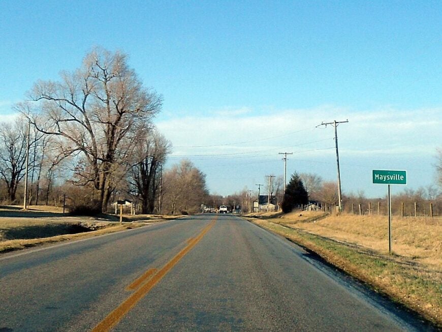
1. Maysville

Maysville’s population barely tops 200, spread among broad cattle pastures astride the Oklahoma line. Locals fish farm ponds, hunt whitetail on family land, and gather for pie auctions at the 1905 schoolhouse turned community hall. Beef ranching, hay production, and part-time work across the state line fuel household incomes.
Long vistas across open ground, a paucity of streetlights, and gravel backroads that rarely see more than one vehicle an hour insulate residents from Northwest Arkansas’s rapid growth.
The old general store closed two decades ago, so neighbors trade eggs and garden produce instead of meeting in a checkout line. Sunsets linger over the prairie, uninterrupted by rooftops or neon.
Where is Maysville?

Maysville occupies the extreme northwest corner of Benton County, three miles east of Oklahoma and five miles south of Missouri. No state highway cuts through town; travelers arrive via a lattice of county roads branching from Arkansas Highway 43.
Gentle hills and state border check stations divert commercial trucking, keeping noise at a minimum. Reaching the hamlet requires a personal vehicle, and locals often joke that GPS thinks the area is still pasture, which is part of its charm.