🔥 Would you like to save this?
Northwest Arizona is a land of long horizons and abrupt edges, where the Mojave Desert drapes into the Colorado Plateau and the air changes with every shift in elevation. Here, Joshua tree forests give way to piñon and juniper, sandstone cliffs drop into blue-green river canyons, and volcanic ridges rise like rust-colored ramparts against the sky.
The Colorado River cuts a deep seam along the western edge, feeding marshes and wildlife refuges before sliding toward Lake Mead, while the interior is stitched together by two-lane highways that seem to unravel into open space.
In order to come up with the very specific design ideas, we create most designs with the assistance of state-of-the-art AI interior design software.
This is not a region of convenience. Settlements cling to mesa rims, canyon bottoms, and pockets of irrigated land, separated by miles of BLM country, reservation lands, and national forest. The distances here are deceptive—what looks close on the map can take hours to reach, the road bending and climbing in slow conversation with the terrain. In summer, heat presses against the skin like a physical weight; in winter, snow can dust the Kaibab highlands while the desert below stays bare and sun-bleached.
The 25 towns in this list occupy those folds and corners where human presence is thin but deeply rooted. Some are fishing or boating outposts along the river, others are mountain hamlets shaded by ponderosa, and a few are little more than crossroads with a handful of buildings. Together, they form a loose constellation of places that endure not by being hidden, but by belonging fully to the land that surrounds them.
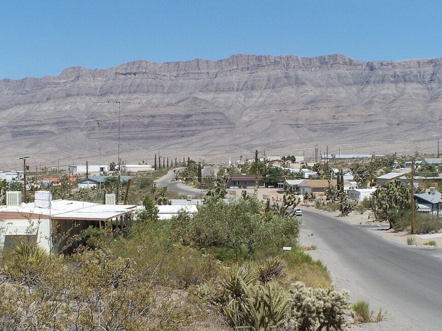
25. Temple Bar Marina

Temple Bar feels like a mirage on the Arizona side of Lake Mead—just a marina, a lodge, and a scattering of desert-camper rigs tucked among creosote and cholla. It’s secluded because everything beyond the boat ramp is miles of national recreation land with no neighborhoods or strip malls in sight.
The vibe is hushed and sun-bleached: bass boats nosing through cobalt coves, ravens riding thermals, and heat shimmering over empty blacktop. Spend the day paddling into skinny inlets, trolling for striped bass, hiking to lake overlooks, or catching sunset from the floating fuel dock.
Work here revolves around marina operations, small maintenance crews, and seasonal guiding. After dark, the shoreline goes ink-black, and the only noise is a gentle slap against hulls. It’s close enough for a weekend, but far enough that time seems to idle with the wind.
Where is Temple Bar Marina?
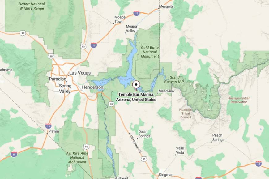
Temple Bar sits in far western Mohave County on Lake Mead’s Arizona shore, roughly 75 miles northeast of Las Vegas. You reach it by a long, lightly traveled spur off US-93 that dead-ends at the water.
With no alternate roads, all visitors come and go the same way, which keeps traffic sparse. Blue water on one side and miles of federal desert on the other make it feel like the edge of the map.
24. Willow Beach
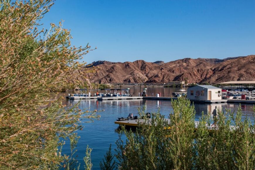
Willow Beach is a tiny river outpost tucked into Black Canyon below Hoover Dam, where emerald water threads between black volcanic walls. It stays secluded because there’s nothing here but an NPS marina, a few cabins, and miles of protected shoreline—no neighborhoods, no neon.
The mood is tranquil and cool even in summer, with trout rising in the shadows and bighorn sheep picking their way along cliffs. Rent a kayak to explore hot springs and quiet coves, fish for stocked rainbow trout, or take a mellow powerboat cruise upstream toward the dam.
Jobs are mostly marina, guide, and maintenance work, with occasional research crews studying the river. When the sun ducks behind the canyon rim, the river turns glassy and silent. It’s the kind of place that reminds you how soft water can make the world feel.
Where is Willow Beach?
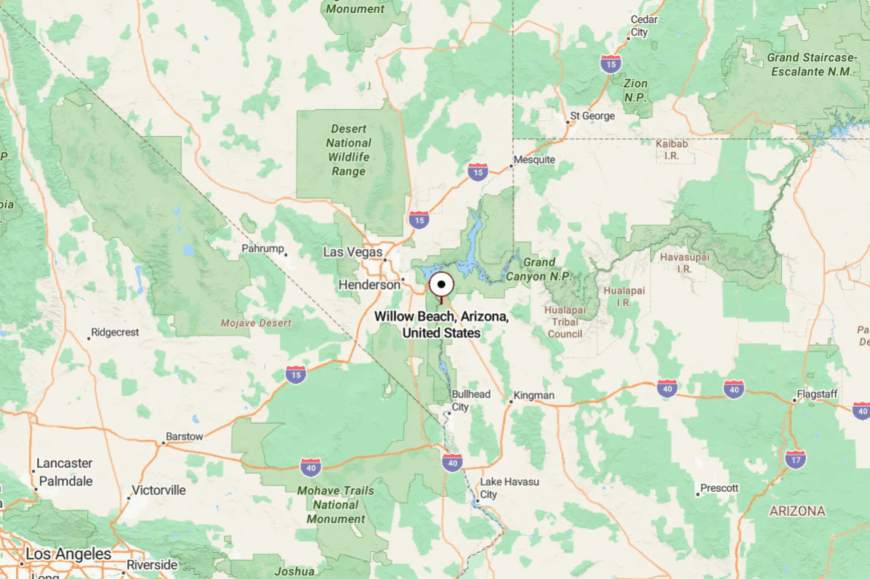
You’ll find Willow Beach off US-93, about 14 miles south of Hoover Dam and 55 miles from Las Vegas. A winding access road drops through volcanic hills to the Colorado River and ends at the marina.
There’s no through route—once you’re down in the canyon, you’re committed to the water and the sky above. That single road and the high walls of Black Canyon keep the bustle far away.
23. Dolan Springs
Dolan Springs spreads wide under Joshua tree flats, a patchwork of dirt lanes and distant porch lights with the Music Mountains on the horizon. It’s secluded because it sits at the far end of a long, two-lane climb from US-93, with federal land hemming in three sides.
Life feels frontier-simple: feed stores, church potlucks, and neighbors swapping trail info at the café. Ride ATVs into the Cerbat foothills, hike off-the-radar canyons, or launch day trips to Grand Canyon West while skipping the crowds back in Vegas.
Many folks work in construction, guiding, or property care, with retirees rounding out the community. At night, wind rustles the Joshua trees, and coyotes carry on long conversations. If you’re craving elbow room, you’ll find it here in spades.
Where is Dolan Springs?

The town sits 30 miles north of Kingman and about 65 miles southeast of Las Vegas, reached via Pierce Ferry Road from US-93. The pavement narrows and rolls, with long stretches of open range on both sides.
Past the last gas station, the road simply keeps going until it peters into desert tracks. That “end-of-the-line” feeling is the point.
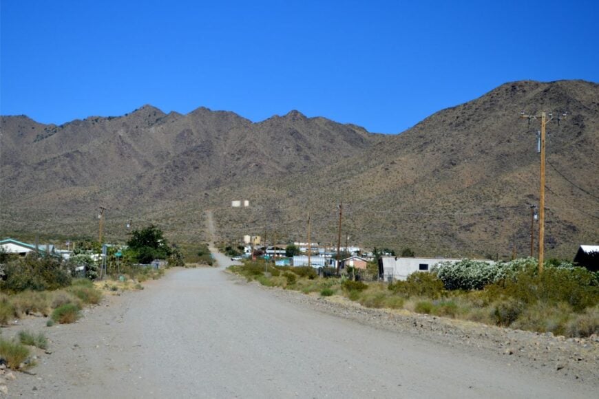
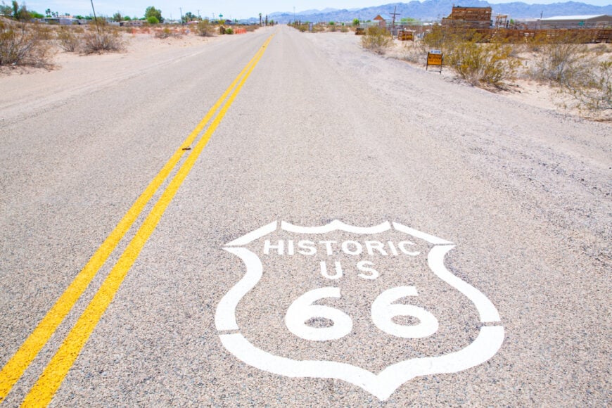
22. Oatman

Oatman is a crinkled mining town clinging to slopes below Sitgreaves Pass, where wild burros wander Main Street like they still own the claim. It’s secluded by design: the twisty, shoulder-less stretch of old Route 66 scares off RVs and anyone in a hurry.
The vibe is half ghost town, half street theater—weathered storefronts, gunfighter skits, and harmonicas wailing in the afternoon shade. Poke into antique shops, photograph the craggy Black Mountains, hike short mine trails, and feed a carrot to a long-eared local.
Most livelihoods hinge on day-trippers, crafts, and a bar or two with decades of dust in the rafters. Even on a busy Saturday, walk a block off Main and the desert swallows the noise. Oatman’s charm is that it still feels like a stubborn holdout from another century.
Where is Oatman?
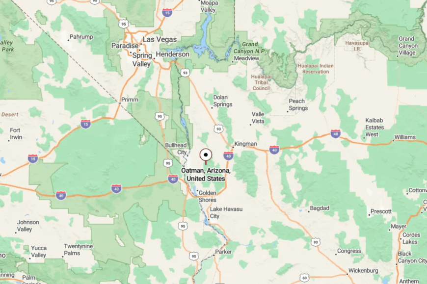
It’s in the Black Mountains of Mohave County, 28 miles southwest of Kingman and 24 miles east of Bullhead City. You reach it via the narrow, winding spine of Historic Route 66 over Sitgreaves Pass.
There’s no fast way in—tight curves and steep grades slow everyone to a crawl. The road alone filters the visitor mix to those who came to linger.
21. Peach Springs

Peach Springs sits low and quiet along the Hualapai Reservation’s stretch of Route 66, gateway to remote canyons few travelers ever see. Seclusion is built into the land—vast plateaus, guarded side roads, and long distances between services.
The feeling is grounded and cultural: cedar smoke, canyon winds, and stories that go back farther than the pavement. Visit the Hualapai Cultural Center, day-trip to Grand Canyon Caverns, or book permitted river or backcountry tours with Hualapai guides.
Jobs center on tribal services, tourism, and ranching. Nights bloom with stars because there’s simply nothing else around to compete. Stay a while, and the quiet begins to carry its own rhythms.
Where is Peach Springs?
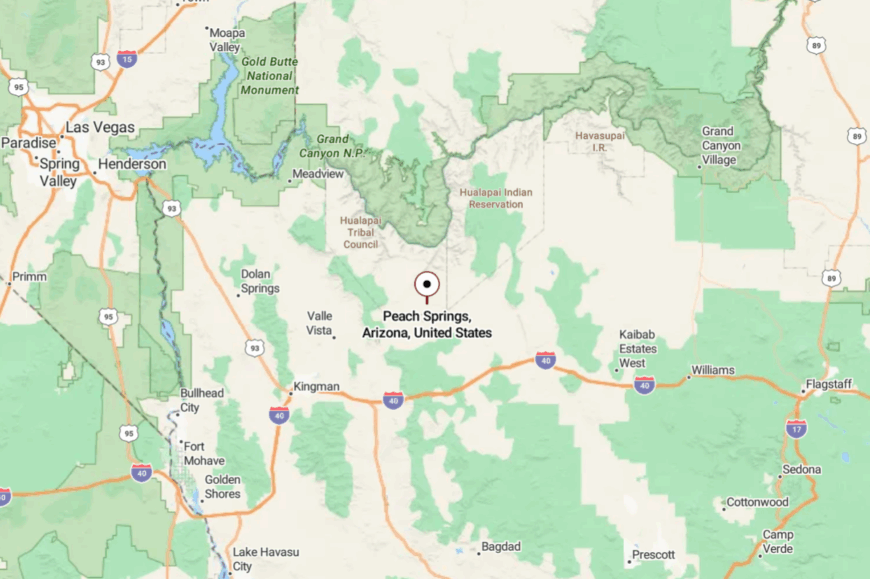
You’ll find it on Historic Route 66 between Seligman and Kingman, about 53 miles from either direction. Interstate 40 swings far to the south, leaving this stretch of the Mother Road lightly used.
Side roads quickly turn to reservation routes and ranch tracks with limited access. The result is a town that’s easy to pass on a map and unforgettable in person.
20. Supai (Havasupai)
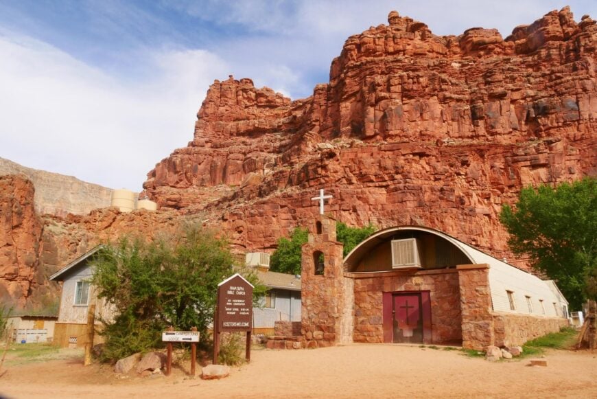
Supai is a village at the bottom of a red-rock canyon, where mail still arrives by pack animal and the creek spills into turquoise waterfalls. It’s secluded in the truest sense—reached only by a strenuous hike, horseback, or helicopter from the rim.
The vibe is gentle and deeply rooted, with gardens tucked beneath cottonwoods and the steady hush of Havasu Creek. With advance permits, hike to Havasu, Mooney, and Beaver Falls; spend off-hours listening to canyon wrens and studying stars that look close enough to touch.
Local livelihoods revolve around tribal services and tightly managed tourism—respectful visitors are welcomed, but capacity stays low. When night returns, canyon walls turn the village into a world of its own. Supai is a reminder that distance can protect beauty.
Where is Supai?
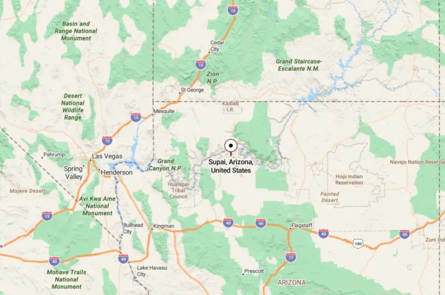
The trailhead sits at Hualapai Hilltop on the far western Havasupai Reservation, roughly 68 miles north of Seligman on reservation and county roads. From there, it’s an 8-mile descent into Havasu Canyon to reach the village.
There’s no road to Supai—only foot, horse, or helicopter access with permits secured in advance. That gatekeeping by terrain and tradition preserves the quiet for residents and allows just a trickle of guests.
19. Fredonia
🔥 Would you like to save this?
Fredonia is a tidy grid of shade trees and field edges at the foot of the Kaibab Plateau, a supply town that never grew beyond its own contented pace. It’s secluded because the nearest big box is hours away and the North Rim shuts down for winter, turning the region into a private corner of Arizona.
The mood is practical and neighborly—feed stores, school games, and the smell of fresh-cut hay. Spend a day exploring Kanab Creek backroads, hike to quiet overlooks on the plateau, or wander Pipe Spring’s historic orchards just up the road.
Work comes from ranching, forestry, and seasonal park jobs. Summer nights draw a dome of stars over the valley. Fredonia feels like the last light before a very large darkness.
Where is Fredonia?
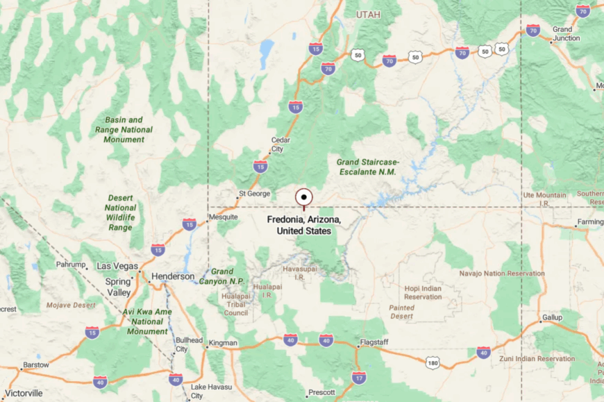
It sits in northern Coconino County just south of the Utah line, five minutes from Kanab and about 80 miles from the Grand Canyon’s North Rim entrance. US-89A and AZ-389 meet here, but both are two-lane and lightly trafficked.
To the south, Kaibab National Forest climbs quickly into ponderosa and aspen, limiting development. That forest wall and the long miles to any metro keep the pace slow.
18. Jacob Lake
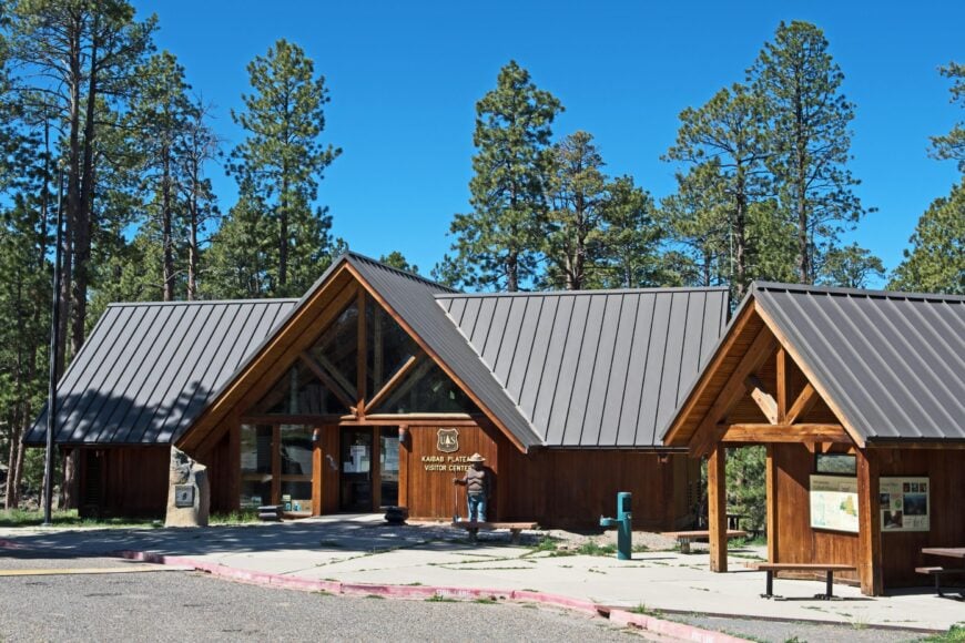
Jacob Lake is more crossroads than town—a lodge, a ranger station, a gas pump, and a cookie counter that fuels North Rim adventures. It’s secluded because it lives at 8,000 feet on the Kaibab Plateau, with snowpack closing roads early and opening them late.
The feeling is alpine and woodsmoky: cool breezes, elk tracks, and trail dust on boots. Hike the Arizona Trail segments, look for California condors at Vermilion Cliffs overlooks, and sip cocoa by the lodge fireplace when storms roll through.
Jobs are seasonal park, lodge, and forest positions. Night skies here are jet-black and loud with silence. Even when you’re just passing through, it’s hard not to linger.
Where is Jacob Lake?
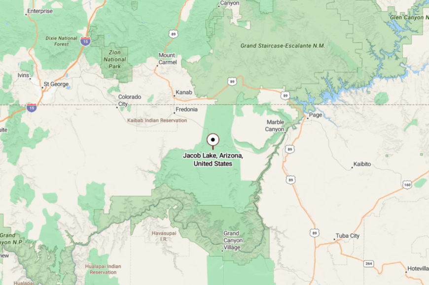
You’ll find it where US-89A meets AZ-67, about 44 miles south of Fredonia and 30 miles north of the North Rim entrance. The approach climbs steadily through piñon into tall ponderosa.
AZ-67 dead-ends at the canyon edge, so Jacob Lake sees only those bound for the Rim or the plateau. That dead-end geography keeps the world at arm’s length.
17. Kaibab (Arizona)
Kaibab is a small community on the Arizona side of the Kaibab Paiute Reservation, tucked among sage flats and red rock shelves. It’s secluded because reservation lands, national monuments, and cliffs form a wide, protected buffer on every side.
The vibe is unhurried and historic—stone springs houses, orchard rows, and a horizon that changes color all day. Explore Pipe Spring National Monument, birdwatch along Meadow Valley Wash, or drive quiet gravel lanes toward the Vermilion Cliffs.
Work centers on tribal services, small agriculture, and monument staffing. When the wind dies, you can hear your footsteps crunch. Kaibab excels at the kind of quiet you don’t need to earn—just show up and breathe.
Where is Kaibab (Arizona)?
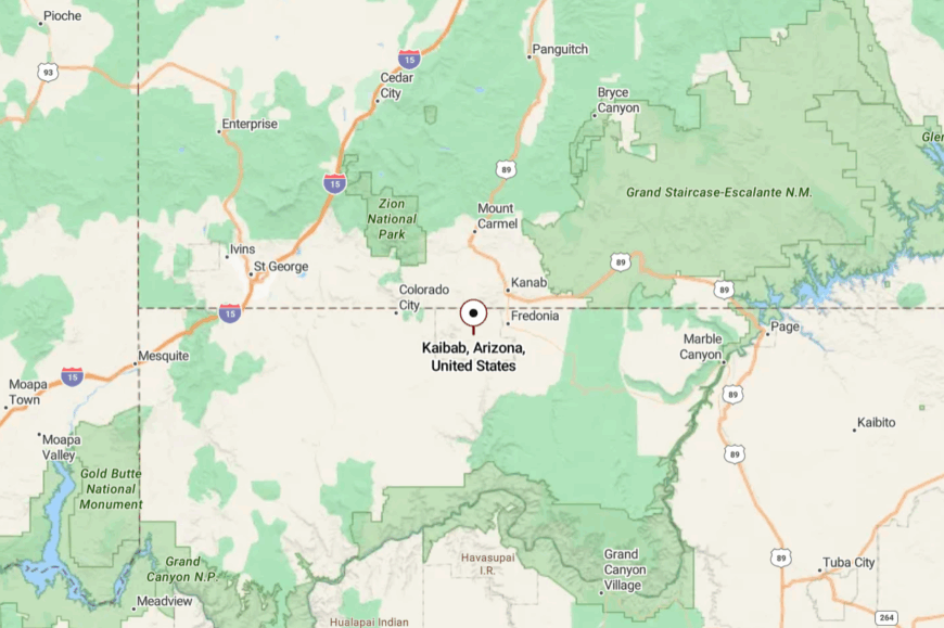
The community lies along AZ-389 about 15 minutes east of Colorado City and 20 minutes west of Fredonia. Low mesas and the Vermilion Cliffs wall off the north, while the Kaibab Plateau rises to the south.
Access comes via the two-lane highway and short reservation roads—there’s no bypass or back way. That simplicity keeps traffic thin and evenings still.
16. Moccasin
Moccasin is a tiny, tree-lined settlement where orchard windbreaks hide old homesteads and springhouses from the highway’s glance. Seclusion comes from the fact that there’s little here beyond homes, a church, and fields—no strip, no bustle.
The mood is pastoral: irrigation ditches murmuring, kids on bikes, and red cliffs catching the last light. Visit nearby Pipe Spring, walk the back lanes under cottonwoods, photograph dawn over the Vermilion Cliffs, or follow dirt roads out to desert overlooks.
Livelihoods lean on ranching, maintenance, and monument work. Night falls gently here, and the stars look like seeds scattered in a furrow. It’s small, sincere, and perfectly content to remain so.
Where is Moccasin?
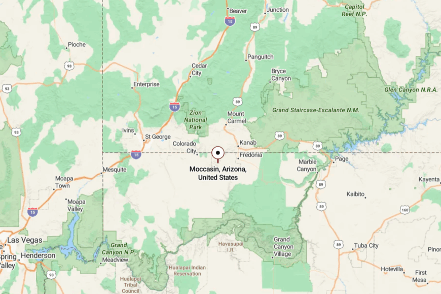
Moccasin sits on AZ-389 between Colorado City and Fredonia, in the far northwest corner of Arizona. Short local roads branch to farms and the monument, but none continue to a larger town.
With cliffs to the north and the Kaibab highlands to the south, Moccasin stays pocketed from growth. You’ll blink and miss it unless you’re looking, which is part of the charm.
15. Grasshopper Junction
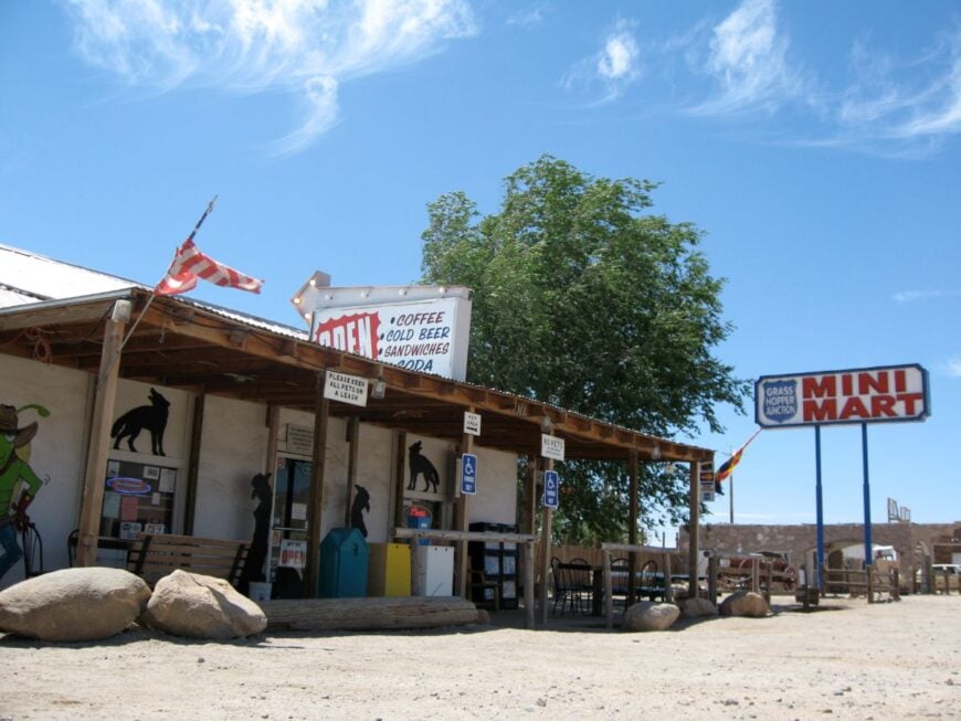
Grasshopper Junction is little more than a crossroads with a handful of buildings and a desert view that runs forever. It’s secluded because it sits between destinations—too far from Kingman to be a suburb, too close to the mountains to sprawl.
The vibe is classic highway outpost: faded signs, a few locals swapping stories, and ravens perched on the gas canopy. Use it as a jumping-off point for backroads into the Cerbats, rockhound around old prospects, or detour toward Chloride’s art valley.
Work is sparse and practical—fuel, repair, ranch help. When the wind hushes, you can hear freight on distant rails. It’s a speck on the map that rewards anyone who stops.
Where is Grasshopper Junction?
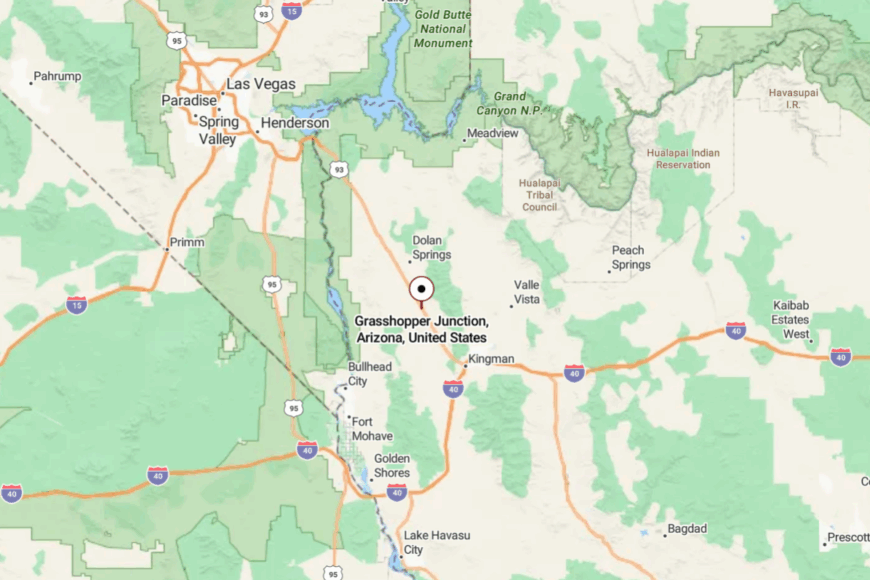
Find it at the junction of US-93 and AZ-68, roughly 20 miles northwest of Kingman. Despite the intersection, there’s nothing dense around it—just open range and low hills.
Side roads quickly turn to dirt and disappear into BLM country. That emptiness on all sides keeps the crossroads strangely calm.
14. Yucca
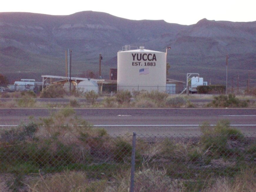
Yucca sprawls across a sun-drenched valley where old palms mark a defunct airpark and the freeway hum fades into the Mojave. It’s secluded because, beyond the interstate exit, it’s all long driveways and desert silence—no downtown, no services beyond a few essentials.
The mood is stubbornly independent: hangar homes, metal shops, and vintage Route 66 relics. Explore sections of old 66, hike to the base of the Hualapais, or roam sandy two-tracks into Joshua Tree flats.
Many residents are makers, retirees, or long-commute workers who value space over convenience. Nights bring a horizon-wide bowl of stars. Yucca is where you go when you want neighbors measured in acres.
Where is Yucca?
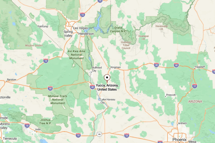
It sits between Kingman and Lake Havasu City along I-40, with Historic Route 66 paralleling the freeway to the north. The exit delivers you to a grid of wide lots fading quickly into open desert.
There’s no alternate approach and little reason to pass through unless you’re headed here. That purposeful detour keeps things quiet.
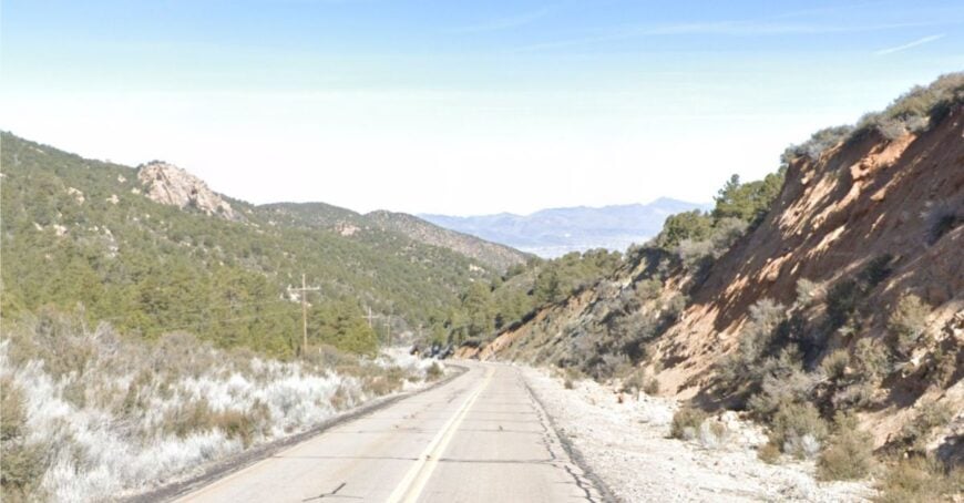
13. Pine Lake (Hualapai Mountains)
🔥 Would you like to save this?
Pine Lake is a handful of cabins tucked into ponderosa and aspen above 6,000 feet, a cool green pocket high over Kingman’s desert. It’s secluded because snow and switchbacks keep the road slow, and the neighborhood is ringed by county park and national forest.
The feel is alpine campfire: deer tracks by the driveway, woodsmoke in the evening, and afternoon thunderheads rolling over the crest. Hike Hualapai Mountain Park’s shaded trails, look for elk at dawn, picnic under white firs, or sip coffee on a deck where the only traffic is hummingbirds.
Income comes from cabin upkeep, hospitality in the park, and remote workers who chased cooler air. After sunset, the forest goes whisper-quiet save for owls. Pine Lake is a reminder that Arizona has seasons if you climb high enough.
Where is Pine Lake?
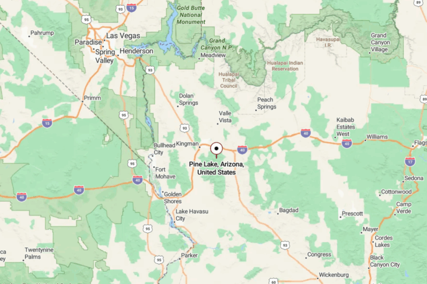
Head 15 miles southeast from Kingman into the Hualapai Mountains on a two-lane highway that narrows and climbs. Past the county park, short residential lanes loop through the pines and stop.
There’s no through road across the range, so visitors turn around the way they came. Trees, elevation, and a dead-end road equal instant calm.
12. Colorado City
Colorado City sits on a tall bench beneath the Vermilion Cliffs, a remote border town that’s learned to keep to itself. It’s secluded because it’s hours from any metro, ringed by federal lands, and linked to Arizona only by one two-lane highway.
The vibe mixes frontier practicality with changing traditions—big sky, big families, and a hum of construction tools most mornings. Hike Water Canyon’s sculpted narrows, picnic at Maxwell Park, or photograph sunrise with the cliffs glowing pink.
Work leans on trades, small agriculture, and cross-border commerce with Utah. Nights are dark and wind-polished. Even as it grows, Colorado City still feels far from the world’s rush.
Where is Colorado City?
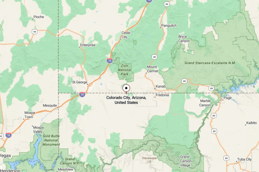
You’ll find it on AZ-389 flush against the Utah line, about 25 miles east of Hurricane, Utah, and 60 miles west of Fredonia. The Vermilion Cliffs wall off the north and benchlands drop away to the south.
There’s no interstate nearby—just the steady ribbon of 389 and a few dirt spurs. That distance is why the town keeps its quiet edge.
11. Mount Trumbull (Arizona Strip)
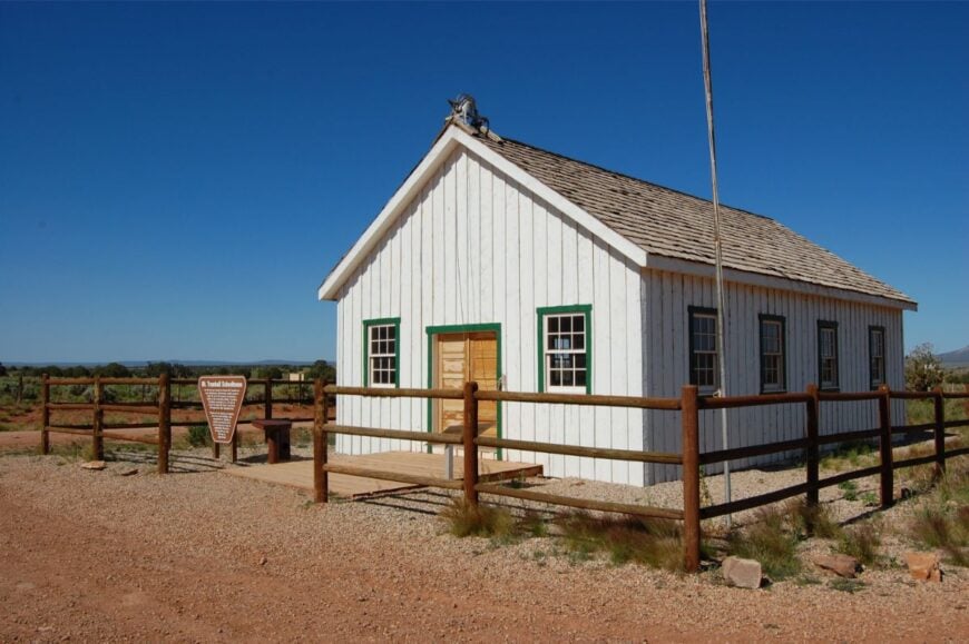
Mount Trumbull isn’t so much a town as a scattered community anchored by a restored one-room schoolhouse and a web of ranch tracks. It’s secluded because it lives on the Arizona Strip—north of the Grand Canyon, south of Utah, and far from pavement in any direction.
The mood is windswept and historic: Juniper woodsmoke, old logging stories, and a horizon that feels unowned. Visit the schoolhouse, continue to Whitmore Overlook for a jaw-dropping view into Grand Canyon, or overnight at the remote Bar 10–area lodges (reservations essential).
Livelihoods are ranching, range maintenance, and a trickle of backcountry tourism. When night falls, the stars feel shockingly close. If you’re seeking the end of the road, this is where it goes.
Where is Mount Trumbull?
It’s deep in the Arizona Strip, roughly 60–80 miles of graded dirt south of St. George, Utah, via County 5 and BLM roads. There’s no fuel, no services, and no cell signal for long stretches—self-sufficiency is mandatory.
The Grand Canyon and Uinkaret Mountains wall off shortcuts, turning the area into a vast cul-de-sac of public land. The reward for the long approach is absolute quiet and canyon light that never gets old.
10. Wikieup
Home to roughly 150 residents, Wikieup sits along the Big Sandy River in a broad sweep of open desert. Rockhounding for jasper and agate, birdwatching beneath cottonwoods, and a plate of mesquite-smoked brisket at Eat at Joe’s BBQ keep visitors occupied.
Small ranches, roadside cafés, and a single service station shape the local economy. Most residents either raise cattle, guide outdoor enthusiasts, or commute south to mines near Bagdad.
Granite boulder hills and endless creosote flats wrap the valley, muffling outside noise. With the nearest Walmart 70 miles away in Kingman and only two paved roads in or out, Wikieup remains distinctly secluded.
Where is Wikieup?
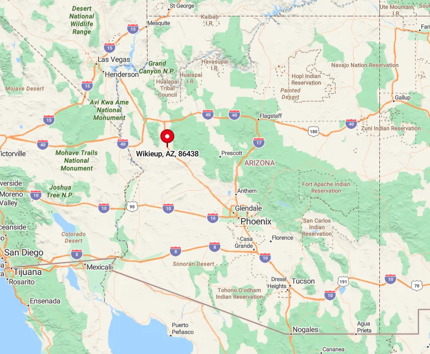
Wikieup lies on US 93 roughly halfway between Wickenburg and Kingman. It occupies a broad valley flanked by the Hualapai and Aquarius Mountains, shielding it from expanding suburbs.
Apart from the highway, access is by county dirt roads that fan into ranch country and end at sandy washes. Drivers cover a scenic 70-mile stretch with no services before reaching the town, reinforcing its far-from-everything feel.
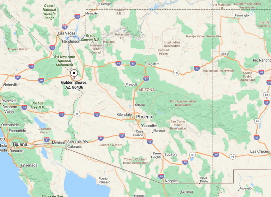
9. Golden Shores (Topock)
Golden Shores, often called Topock, counts about 1,900 full-time residents spread across generous parcels along the lower Colorado River. Kayaking through Topock Gorge, fishing for striped bass, and cruising the Havasu National Wildlife Refuge provide daily recreation.
Vacation rentals, modest marinas, and seasonal construction jobs are the chief industries, supplemented by retirees’ pensions. Homes back up to mesquite marshes protected by federal land, so commercial growth remains minimal.
No stoplights pierce the night, and the nearest supermarket sits 25 miles away in Bullhead City. This buffer of wetlands, river channels, and Bureau of Land Management acreage keeps Golden Shores pleasantly removed from city bustle.
Where is Golden Shores?
🔥 Would you like to save this?
The community rests at Arizona’s western edge, where Interstate 40 crosses the Colorado River into Needles, California. Despite the interstate, a four-mile detour on County Route 1 hides neighborhoods behind berms and cottonwood thickets.
Travelers who exit the freeway find a lone gas station before a two-lane road winds past sloughs to waterfront homes. Many boaters arrive via the river itself, highlighting the area’s semi-isolated setting.
8. Truxton
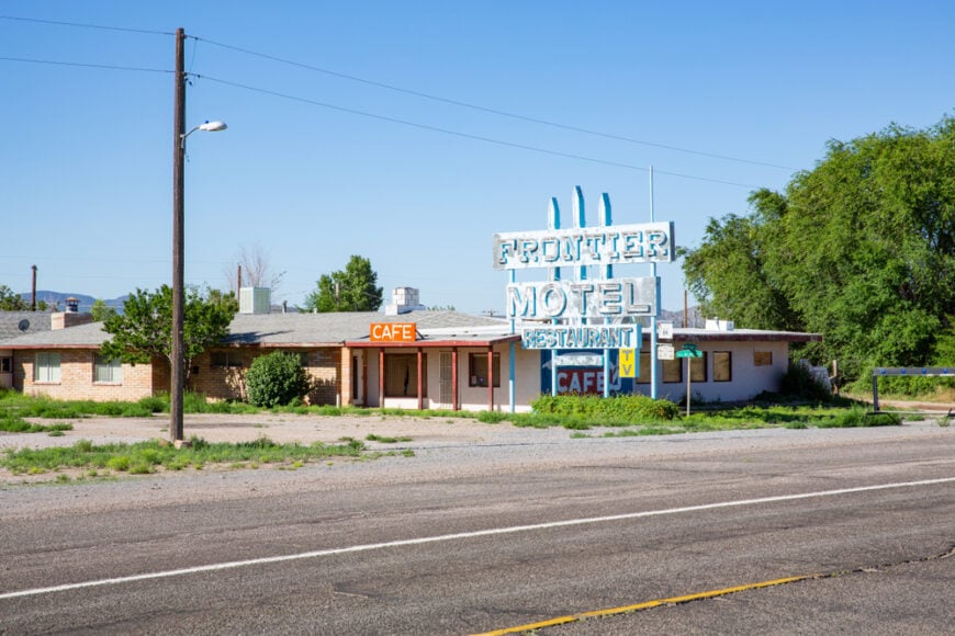
Only about 100 people remain in Truxton, a fading service point on Historic Route 66. Visitors photograph vintage neon at the Frontier Motel, sip coffee at the century-old café, and wander open rangeland dotted with Joshua trees.
A tiny school district, cattle ranching, and highway gas sales support locals. After Interstate 40 bypassed the area, commercial traffic dwindled and the town slipped into quiet backwater status.
Open rangeland stretches in every direction, separating homesteads by acres instead of blocks. With the distant Peacock Mountains as a backdrop and patchy cell coverage, Truxton feels worlds away from the nearest mall.
Where is Truxton?
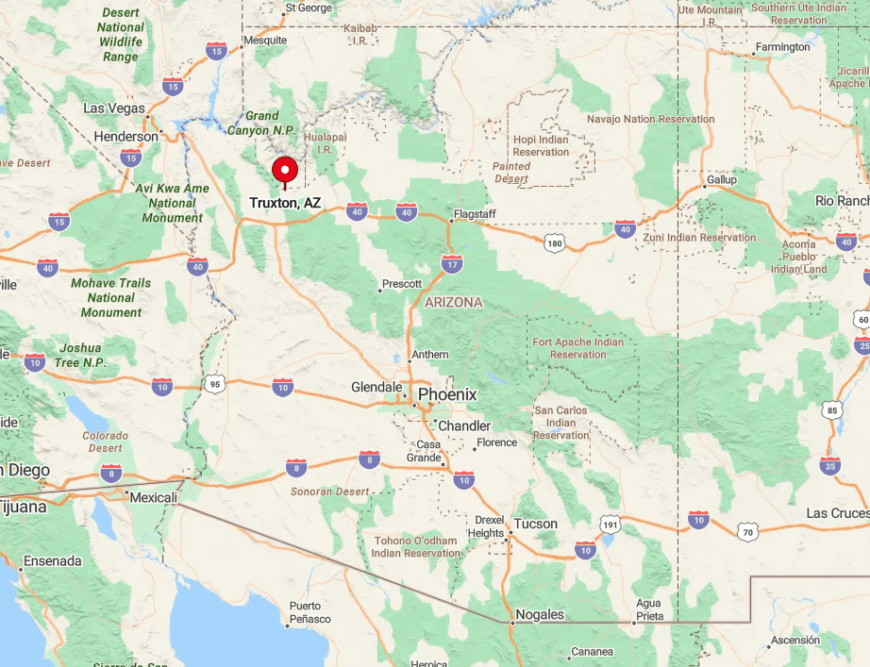
Truxton rests 42 miles east of Kingman along one of the most remote portions of Route 66. Limestone mesas and grazing leases surround the settlement, insulating it from development.
Drivers must stay on the historic highway, as no paved side roads connect to Interstate 40 for nearly 30 miles. That single two-lane ribbon, beloved by nostalgia seekers, is the only practical way in or out.
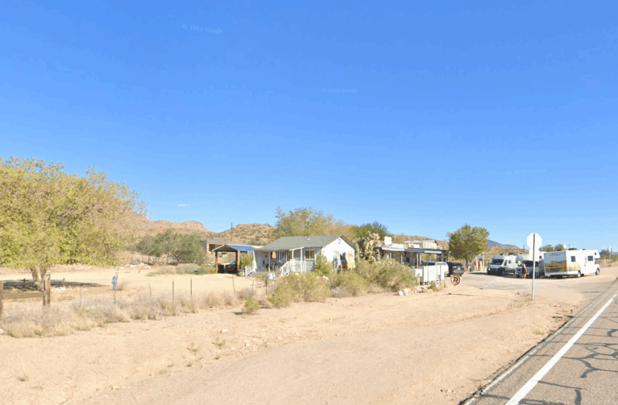
7. Valentine
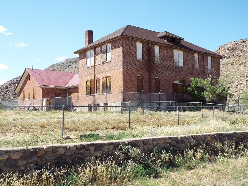
Valentine’s year-round population hovers near 40, making its old railroad siding feel almost abandoned. Day trips to the Keepers of the Wild Nature Park, birding along Truxton Wash, and photographing the 1924 schoolhouse occupy passersby.
Employment centers on the wildlife sanctuary, a post office, and seasonal ranch work. No retail strip exists, and evenings are punctuated only by distant freight whistles.
Prairie grasses, basalt mesas, and federal refuge lands form a wide buffer around the hamlet. Such sparse settlement keeps density well below one hundred people per square mile, cementing its seclusion.
Where is Valentine?
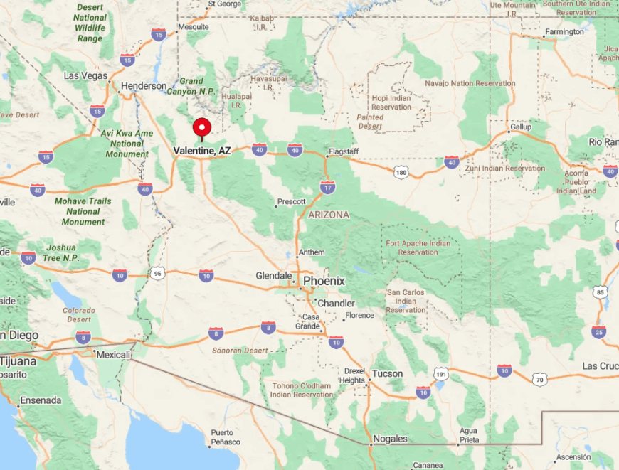
The community lies on Route 66 about 30 miles northeast of Kingman near the Hualapai Reservation. Low ridges shield it from Interstate 40 to the south, and no connecting route links the two corridors.
Visitors follow the Mother Road’s gentle curves until a solitary sign announces Valentine. The lack of alternative access and services limits traffic to wandering road-trippers.
6. Hackberry
Hackberry counts roughly 70 residents scattered along a hidden stretch of Historic Route 66. Travelers linger at the photogenic Hackberry General Store, spot pronghorn on surrounding ranches, and explore limestone bluffs riddled with old mine shafts.
Cattle ranching, small-scale tourism, and freelance artistry underpin the micro-economy. Because the original townsite sits several miles off the modern highway alignment, passing cars rarely notice it.
Rugged cliffs and volcanic hills envelope the community, blocking cellular signals and expanding sunset views. The absence of streetlights and condos underscores why Hackberry feels like a pocket of the past.
Where is Hackberry?
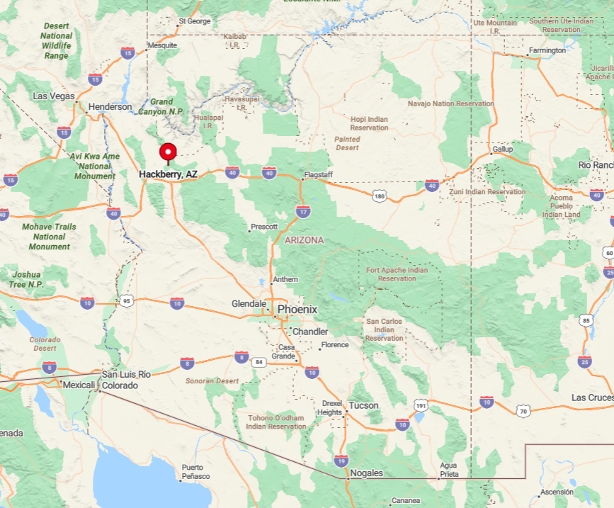
Hackberry is situated 24 miles northeast of Kingman on the eastern leg of Route 66. A bend in the old road slips behind limestone bluffs, hiding the town from the faster state highway that bypasses it.
Visitors must remain on the historic alignment, since no numbered exits guide them from Interstate 40. This detour, coupled with miles of open range, makes arrival feel like stepping backstage in Arizona history.
5. White Hills
White Hills supports about 300 off-grid aficionados and hobby miners who prize its broad sage basins between the Cerbat and White Hills ranges. Recreation revolves around rock collecting, target shooting on BLM land, and exploring remains of 1890s silver diggings.
Many households rely on solar power, small-scale mining claims, and home-based trades for income. The settlement sits at the end of a 14-mile county gravel road, so casual tourists seldom stumble in.
Without municipal services or street-side businesses, nighttime quiet is broken only by wind through creosote. Distance, rough access, and vast federal tracts ensure White Hills retains its off-the-radar character.
Where is White Hills?
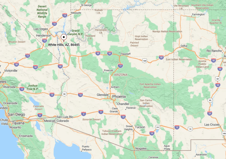
The hamlet lies north of Dolan Springs, about 55 miles from Las Vegas via US 93. After a ranch gate marks the turn, gravel White Hills Road snakes past Joshua tree flats before reaching scattered cabins.
No public transport serves the area, and even mail delivery requires a daily 30-mile round trip. These logistical hurdles keep the community quietly tucked away from the Las Vegas corridor.
4. Littlefield
Littlefield’s permanent population circles 350, though its zip code covers a wide swath of ranchland north of the Virgin River Gorge. Locals ride horses along sandy arroyo trails, launch rafts on the Virgin River, and venture to nearby Mesquite, Nevada, for golf and groceries.
Agriculture, motel work, and service jobs in Mesquite form the financial base. Cut off from the rest of Arizona by the deep Virgin River Gorge, the area functions almost like an island.
Wide pastures, mesquite groves, and minimal lighting grant residents stunning dark-sky views. Being more than 100 miles from the nearest Arizona city services, Littlefield exemplifies geographic isolation.
Where is Littlefield?
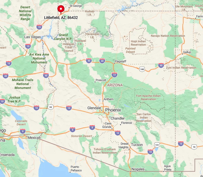
Littlefield nestles in Arizona’s extreme northwest corner just off Interstate 15 near the Nevada line. A single interstate interchange links it to the outside, yet steep canyon walls rise immediately south, preventing alternate routes to the state’s interior.
Most supplies arrive by trucks that detour through Nevada or Utah before re-entering Arizona. Travelers reach the enclave only by I-15, making its setting feel oddly detached from the rest of the state.
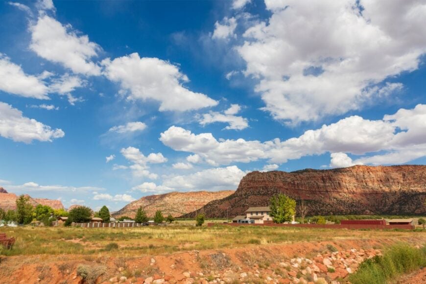
3. Cane Beds
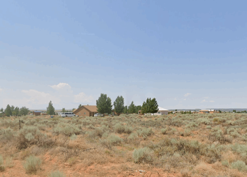
Approximately 500 residents call Cane Beds home, their houses scattered among red-rock canyons and ponderosa-lined backroads near the Utah border. Hiking the Squirrel Canyon Loop, riding ATVs to hidden slot canyons, and browsing roadside stands for local honey fill weekend hours.
Small ranching operations, construction trades, and home-based crafts keep the local economy modest yet steady. Over half of the surrounding land remains undeveloped, and parcel sizes often exceed five acres, leaving plenty of breathing room.
A history as a secluded polygamous enclave lingers, adding to its preference for privacy. The mix of sparse development and towering sandstone walls makes Cane Beds feel far from mainstream tourism.
Where is Cane Beds?
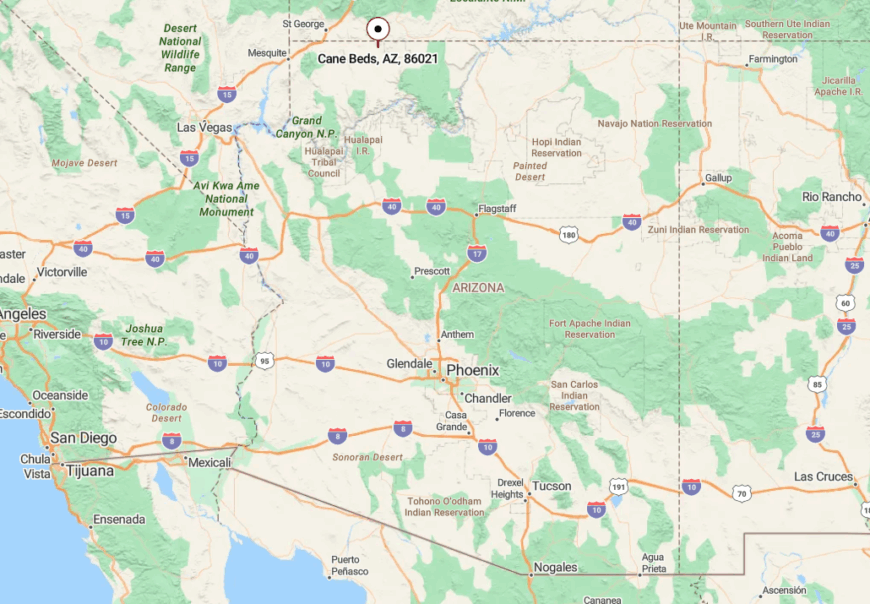
The settlement sits two miles south of the Utah line, reached from Arizona Highway 389 via a short county road. Kaibab Plateau forests to the south and the sheer Vermilion Cliffs to the north corral the community within a natural amphitheater.
No public transit serves the area, and winter snow can temporarily close the backroads. Visitors typically drive from St. George, Utah, an hour away, underscoring the out-of-the-way location.
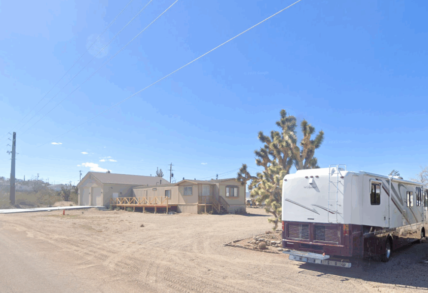
2. Chloride
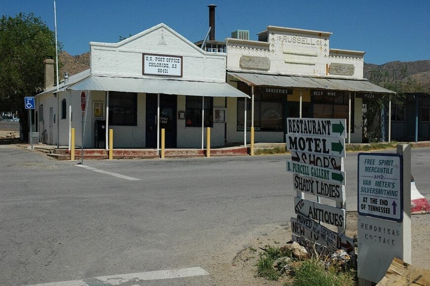
Chloride, Arizona’s oldest continually inhabited mining camp, shelters about 270 residents among the Cerbat Mountains. Tourists explore whimsical outdoor murals in the Roy Purcell art valley, browse antique shops, and attend monthly gunfighter reenactments on the dusty main street.
A few cafés, art studios, and small-scale mining claims provide employment, with many residents retired. The town sits four miles off US 93, hidden behind low hills that mute highway rumble and discourage casual detours.
Night skies glow with Milky Way brilliance thanks to minimal lighting. This blend of topographic shielding and limited population preserves Chloride’s art-filled ghost-town vibe.
Where is Chloride?
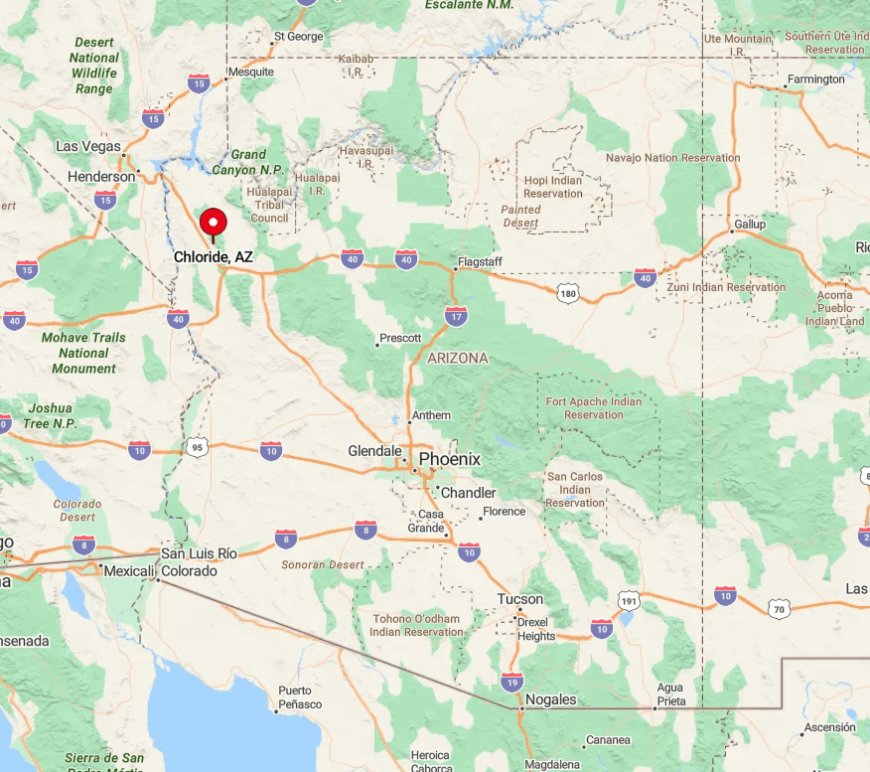
Chloride lies 24 miles north of Kingman, accessible by a signed but lightly traveled county road. The pavement narrows as it winds through Joshua tree flats, then crests a rise before descending into the sheltered valley townsite.
No through road continues beyond Chloride, so all visitors exit the same way they arrived. Such cul-de-sac geography reinforces the feeling of stepping into a pocket of bygone Arizona.
1. Meadview
Perched atop Grapevine Mesa overlooking Lake Mead, Meadview hosts roughly 1,500 residents dispersed across one-acre desert lots. Boating from South Cove, photographing Joshua tree forests, and stargazing on crystal-clear nights headline local pastimes.
Property management for vacation homes, guiding lake excursions, and small retail at the community center provide most jobs. The hamlet sits 60 miles from Kingman at the very end of a winding county route that terminates at the mesa rim.
With no passing traffic, evenings are hushed enough to hear burros bray in distant washes. Sweeping views of Lake Mead and an absence of urban glare secure its reputation for absolute quiet.
Where is Meadview?
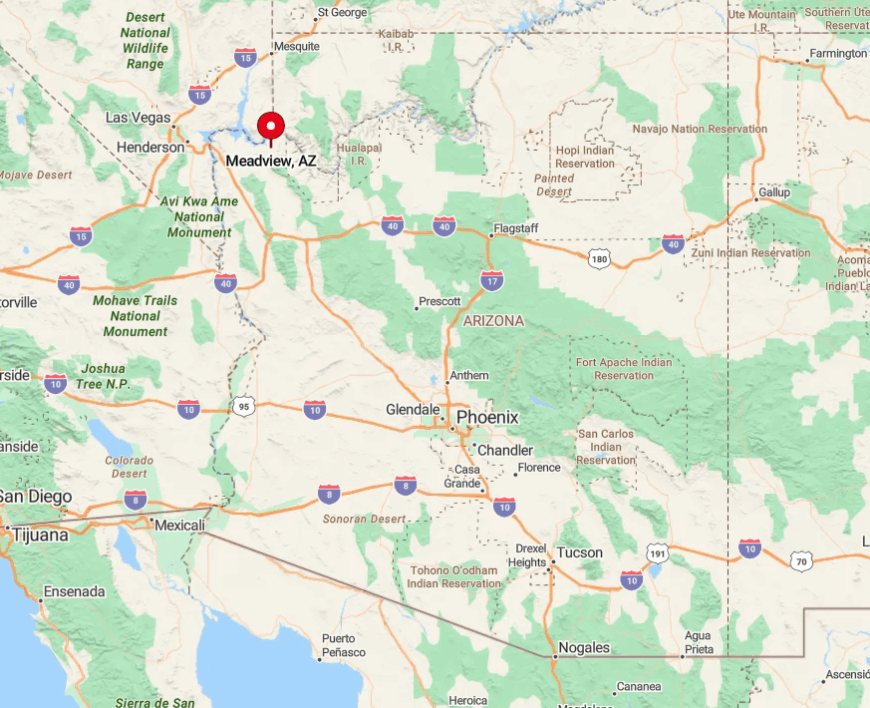
Meadview occupies the northeastern tip of Mohave County high above the Colorado River where Lake Mead begins. The sole paved access, Pierce Ferry Road, climbs 20 miles from Dolan Springs before ending at the town.
Beyond that point, only dirt tracks lead to the Grand Canyon’s western reaches, so through traffic is nonexistent. Visitors usually drive from Kingman or Las Vegas, carving a half-day journey that underlines the mesa’s isolation.


