🔥 Would you like to save this?
Wide basins, lonely dirt roads, and dramatic mountain skylines keep northern Nevada full of pockets where crowds rarely gather. Our team gathered 25 of the region’s most tucked-away communities—places where a porch light still doubles as streetlight and the nearest big-box store sits hours down the highway.
Each town offers its own blend of history, scenery, and small-town grit, yet all share the sweet hush that settles over the Great Basin after sunset.
In order to come up with the very specific design ideas, we create most designs with the assistance of state-of-the-art AI interior design software. Also, assume links that take you off the site are affiliate links such as links to Amazon. this means we may earn a commission if you buy something.
From alpine hamlets framed by 11,000-foot peaks to tiny rail stops where the wind competes only with passing freight cars, these spots reward travelers and future residents who crave elbow room.
Hidden hot springs, century-old stone cottages, and wildlife refuges add layers of discovery once you arrive. Pack plenty of fuel, roll down the windows, and slip into the slower rhythm that still defines Nevada’s out-there north.
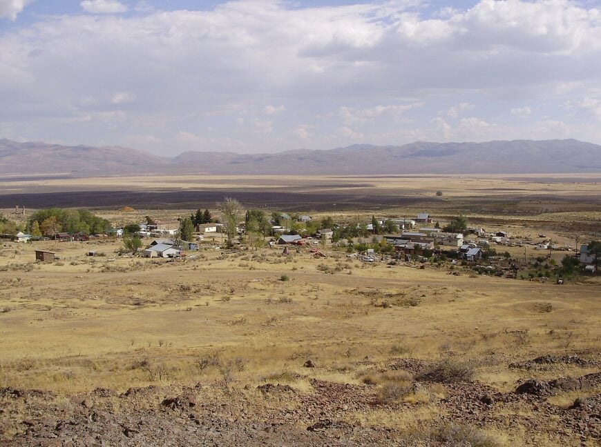
25. Lund
Lund rests quietly in the vastness of White Pine County, surrounded by miles of sagebrush, open desert, and distant mountains that catch the last light of day. Far from interstates and tucked along a remote stretch of U.S. Route 318, it feels like a place built to be apart—where time moves slow and the silence runs deep.
The town is small, with wide dirt roads, a schoolhouse, a church, and fences that stretch farther than sight. Visitors can explore the nearby Ward Charcoal Ovens, stargaze under some of the darkest skies in the country, hike into the Schell Creek Range, or stop by for a slice of pie at the family diner that still knows everyone’s name.
Most residents farm or ranch, their work etched into the land like the tracks of their cattle and trucks. There’s a raw openness here, quiet but vast, rugged but calm. It’s the kind of place that reminds you just how far the world can stretch—and how peaceful it feels when it does.
Where is Lund?
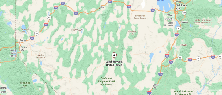
Lund, Nevada sits in eastern White Pine County, nestled along Nevada State Route 318 at an elevation of about 5,560 feet. It’s roughly 32 miles southwest of Ely, reached by following SR 318 through high desert and ranch country.
The drive passes wide valleys, sparse sagebrush, and few signs of settled life until the small town appears. It’s a settlement where the sky feels vast, the land feels quiet, and the pace of the world gently eases.
24. Baker
Baker sits at the far eastern edge of Nevada, cradled in the shadow of the Snake Range and tucked just outside the entrance to Great Basin National Park. It’s a long way from any city, with only a two-lane highway connecting it to the world, and the desert stretching wide in every direction.
The town is tiny—just a handful of homes, a post office, a café or two—but it feels vast, thanks to the open sky and the quiet that settles over everything. Visitors hike the alpine trails of Wheeler Peak, explore the Lehman Caves, stargaze under some of the darkest skies in the country, or browse handmade goods at the local artist co-op.
Tourism sustains the seasons, while some residents ranch or live simply, drawn by solitude and the landscape itself. Life here is slow, real, and deeply shaped by the rhythms of nature. It’s the kind of place that reminds you how much beauty lives at the edge of everything.
Where is Baker?

Baker is tucked into the far eastern edge of Nevada, just a few miles from the Utah border and nestled beneath the shadow of Great Basin National Park. It sits about 60 miles east of Ely along U.S. Route 50—dubbed “The Loneliest Road in America”—and is reached via a quiet spur road that winds past open desert and rugged mountain views.
The approach feels timeless, with vast silence broken only by the sweep of wind or the sight of distant mule deer. Baker is close enough to get to—but just remote enough to make you forget where you came from.
23. Manhattan
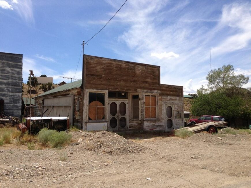
Manhattan lies tucked in the remote canyons of central Nevada, surrounded by the Toquima Range and miles of open desert that keep it hidden from most maps and minds. Reached only by narrow state highways that wind through sagebrush and silence, it feels like a relic cradled in time.
The town itself is quiet and weathered—scattered cabins, mining-era ruins, and a saloon that still carries the scent of old wood and dust. Visitors can hike the rugged trails into the mountains, explore abandoned mining shafts, camp beneath a sky crowded with stars.
A few locals remain—some ranch, others mine, but most stay for the solitude and space. The past is present here, layered into the land like seams in stone. It’s the kind of place that reminds you how far away—and how deeply rooted—a town can be.
Where is Manhattan?
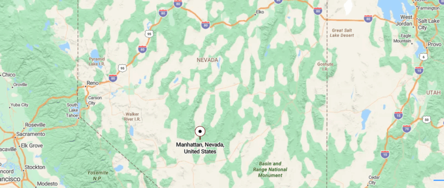
Manhattan, Nevada lies deep in the central part of the state, tucked into the Toquima Range of Nye County. It’s about 50 miles north of Tonopah, reached by a narrow highway that gradually gives way to gravel roads climbing through sagebrush valleys and foothills.
The town appears almost suddenly—quiet, weathered, and flanked by old mining remnants and pine-covered slopes. You don’t stumble upon Manhattan by accident; you arrive with intention, and in return, it offers the hush of time standing still.
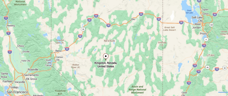
22. Kingston
Tucked into the edge of the Toiyabe Range, Kingston rests at the mouth of a high desert canyon, far from the hum of highways and surrounded by wide-open Nevada silence. You reach it only by a quiet road off U.S. 50, and once you’re there, the world feels filtered through pine, wind, and mountain light.
The town is small—just a handful of cabins, a post office, and a lodge where neighbors gather for music and stories. Visitors come to fish Kingston Creek, hike the alpine trails leading into the Humboldt-Toiyabe National Forest, soak in nearby Spencer Hot Springs, or simply breathe in the stillness that wraps the valley.
Some locals ranch or work seasonally, while others are here for the seclusion itself. The air is clear, the nights are velvet-dark, and time has no urgency. It’s the kind of place that reminds you how good it feels to disappear into the hills.
Where is Kingston?

Kingston is tucked into the southern part of Lander County, nestled at the foot of the Toiyabe Range near the mouth of Kingston Canyon. It’s located about 20 miles south of Austin and roughly 90 miles north of Tonopah, along quiet State Route 376.
The road climbs gently through sagebrush and pine before opening into a small, secluded settlement. In Kingston, the silence lingers and the mountains feel near enough to touch—close to the road, but a world apart.
21. Currie
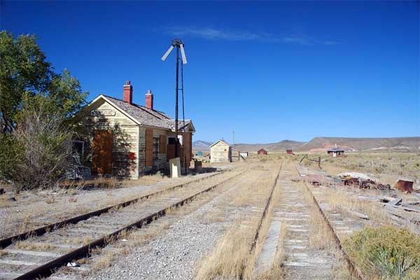
Currie sits quietly in the vast emptiness of northeastern Nevada, surrounded by desert plains and distant hills where the horizon seems to stretch forever. Once a bustling railroad town, it’s now nearly forgotten—reached only by long, lonely roads with no gas stations for miles.
The vibe is haunting yet peaceful, with abandoned buildings, rusting rail remnants, and the occasional whisper of wind through tall sagebrush. Visitors might photograph the old depot, explore the remnants of the Nevada Northern Railway, hike the rugged terrain nearby, or camp under skies so dark they reveal galaxies.
There’s no store, no crowd—just echoes of the past and a silence that settles deep. Ranching continues on the land, but the town itself holds more memory than motion. It’s the kind of place that reminds you how quiet history can be when left untouched.
Where is Currie?
Currie sits in the remote eastern part of Elko County, Nevada, about 75 miles north of Ely along a quiet stretch of highway. Once a key stop on the old Nevada Northern Railway, it now rests quietly between long stretches of desert and low hills.
You reach it by two-lane roads that feel almost forgotten. Currie’s silence is deep, broken only by wind and memory.
20. Belmont
Belmont rests in the high desert hills of central Nevada, miles from the nearest town and surrounded by sagebrush, wind, and the faded traces of its silver mining past. Getting there means leaving the pavement behind and following dusty roads that twist through open country, where wild horses outnumber cars.
What’s left is a scattering of weathered buildings—an old courthouse, stone ruins, and a saloon that still swings its doors on summer weekends. Visitors walk through 19th-century history, photograph the crumbling facades, camp beneath starlit skies, or explore the mining shafts tucked into nearby hills.
There’s no gas station, no cell service, and no rush—just time suspended in still air. A few seasonal residents and history buffs keep the spirit alive, but the town mostly belongs to memory and land. It’s the kind of place that reminds you how quiet the past can be when no one interrupts it.
Where is Belmont?

Belmont sits high in the Toquima Range in central Nye County, about 45 miles northeast of Tonopah. You reach it by leaving U.S. 50, then following SR-376 and a series of quieter roads that climb through open sagebrush and mountain foothills.
The pavement fades as you near the town, revealing weathered buildings and mining ruins. Belmont feels like a place paused in time—close enough to find, but distant enough to be forgotten.
19. Fish Lake Valley

🔥 Would you like to save this?
Fish Lake Valley stretches wide beneath the shadow of the White Mountains, where the Nevada desert meets the California border in a hush of sun, sagebrush, and sky. It’s not near anything—no highways, no cities—just long roads that seem to vanish into heat shimmer and silence.
The community is sparse and scattered, with ranch houses set far apart and a sense that time drifts slower here. Visitors soak in the natural hot springs, explore ancient petroglyphs in the surrounding hills, hike through the nearby Monte Cristo Range, or catch a fiery sunset over the valley floor.
Farming and ranching remain the heart of daily life, with locals living close to the land and far from the noise. The air carries nothing but wind and the occasional hawk’s cry. It’s the kind of place that reminds you how vast and deeply still the world can be.
Where is Fish Lake Valley?

Fish Lake Valley lies in the far western reaches of Nevada, nestled at the base of the majestic White Mountains in Esmeralda County. It stretches along U.S. Route 6/95, about 40 miles south of Tonopah, before you turn west onto a quieter county road that threads through the valley floor.
The ascent takes you past sagebrush flats and scattered alkali lakes, with the road narrowing and the surroundings growing increasingly still. The valley unfolds in hushed vastness—a flat, open space that invites you in, yet reminds you how far you’ve come from everything familiar.
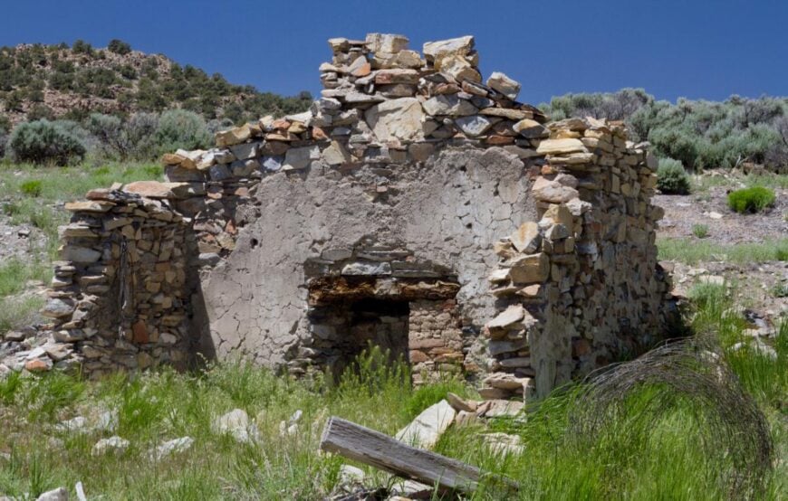
18. Tybo

Tucked deep within the Hot Creek Range, Tybo sits hidden among rugged hills and narrow canyons, far from highways and nearly forgotten by time. Reached only by remote dirt roads that wind through Nevada’s central high desert, the town feels like a ghost folded into the land itself.
What remains is haunting and beautiful—stone ruins, crumbling smelters, and weathered cabins resting quietly under sun and shadow. Visitors come to explore the abandoned mining relics, hike the silent trails through sage-covered hills, photograph the ruins at dusk, or camp beneath skies so clear they feel untouched.
There’s no store, no traffic, and no modern distractions—just the echo of what once was. The memory of mining lingers in the bones of the town, though today, only wind and wildlife call it home. It’s the kind of place that reminds you how the past can linger, gently, in the middle of nowhere.
Where is Tybo?
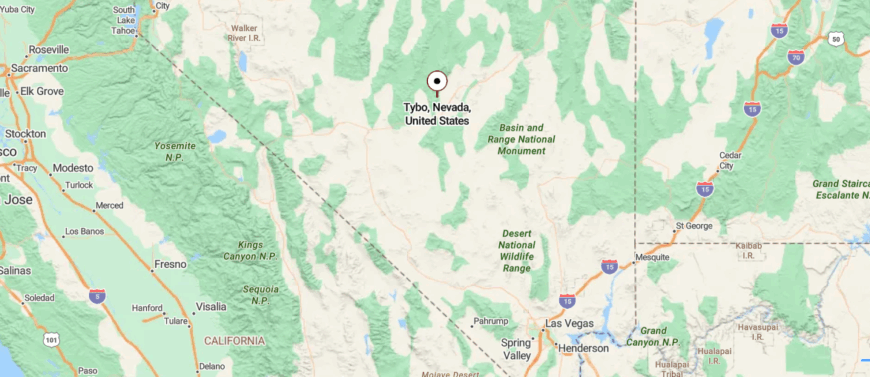
Tybo sits on the eastern flank of the Hot Creek Range in remote Nye County, about 8 miles northwest of U.S. Route 6 and 10 miles from Warm Springs. Founded in the 1870s during a silver and lead boom, it once thrived with hundreds of residents.
You reach it by driving Highway 6, then turning onto a graded dirt road that climbs into the canyon. Tybo feels frozen in time—its kilns and ruins quiet beneath the wide Nevada sky.
17. Warm Springs
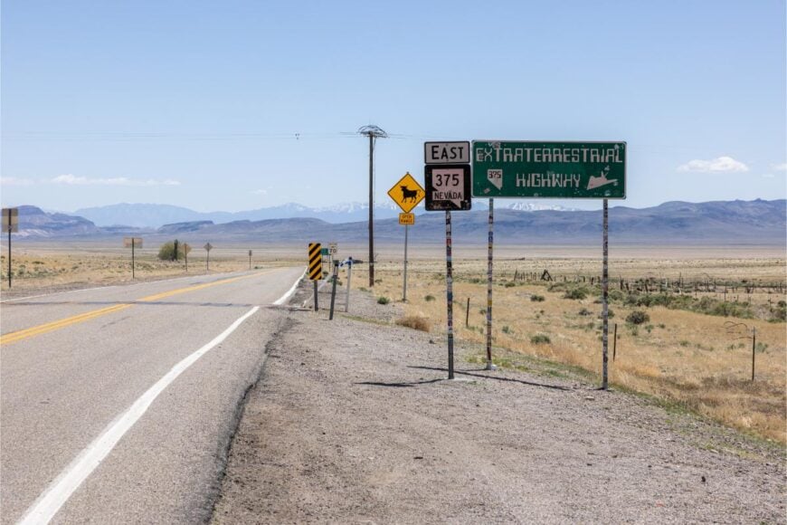
Warm Springs lies at the lonely crossroads of U.S. Routes 6 and 375, surrounded by wide desert basins and distant mountain ridges that stretch endlessly beneath open sky. There are no neighborhoods, no shops—just the empty shell of an old motel, a few scattered buildings, and the silent steam rising from a natural hot spring behind a wire fence.
The nearest town is hours away, and the land in between hums with wind, dust, and solitude. Travelers stop to soak in the hot spring or watch the sun dip behind the Pancake Range, maybe wander the old foundations left from a time when the town had life and motion.
Ranching happens quietly nearby, but the town itself feels almost spectral—more atmosphere than place. It’s still, stark, and strangely soothing. It’s the kind of place that reminds you how completely a landscape can swallow time.
Where is Warm Springs?
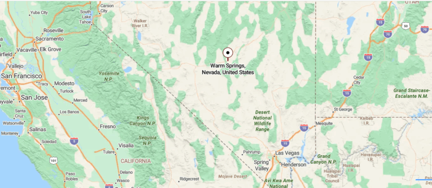
Warm Springs sits in central Nye County, Nevada, nestled in the Tonopah Basin at the junction of U.S. Route 6 and State Route 375—the latter known as the “Extraterrestrial Highway” . Located roughly 50 miles east of Tonopah, it lies near the mountain pass dividing the Kawich and Hot Creek ranges .
You access it directly from Highway 6, then pause at the junction before stepping off into a scattering of stone cabins and shaded springs beside the road. The only movement now is the warm waters flowing into small pools—a ghostly pause in the desert, where civilization ends and silence begins.
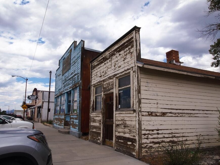
16. Silver City
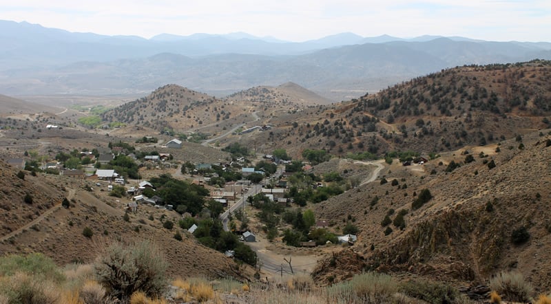
Silver City nestles quietly in a canyon between Virginia City and Dayton, yet it feels worlds away from the tourist bustle just up the road. Shielded by steep hills and narrow curves, it’s a place you don’t stumble into—you arrive because you were looking for something slower, quieter, more thoughtful.
The town’s historic homes, crumbling stone walls, and winding paths tell stories older than most maps, and the air carries the scent of dust, pine, and time. Visitors stroll past 19th-century miners’ cottages, hike toward the old Comstock trails, attend a local art show in the shaded corners of town.
A small community of artists, historians, and longtime locals keeps the spirit alive—not through spectacle, but through presence. There’s no rush here, only the steady hum of wind over stone. It’s the kind of place that reminds you the richest places aren’t loud—they endure in quiet.
Where is Silver City?
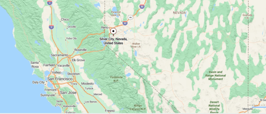
Silver City sits in Lyon County, Nevada, tucked into Gold Canyon just below Devil’s Gate, about 5 miles west of Dayton and 3 miles south of Virginia City. Founded during the 1859 silver boom, it once thrived with mills and iron works serving the Comstock mines.
You reach it via State Route 342, winding through canyon hills into a cluster of historic buildings. Silver City feels preserved and quiet—easy to reach, yet steeped in a silence that hints at its storied past.
15. Gabbs
Gabbs rests at the edge of the Paradise Range, surrounded by open desert and endless sky, where the nearest major town is over an hour away and the roads stretch without interruption. Once a company town built around magnesium mining, it now stands quiet and sparse—just a grid of modest homes, a school, and the ever-present backdrop of sunbaked hills.
The isolation is tangible; there are no stoplights, no chain stores, and the silence after dusk is complete. Visitors might hike the nearby hills, explore old mining ruins, stargaze under a sky untouched by light pollution, or visit Berlin-Ichthyosaur State Park just a short drive away.
Mining still plays a role in the local economy, but many stay for the solitude and connection to the stark, beautiful land. The wind moves freely here, and time feels slower, more intentional. It’s the kind of place that reminds you how quiet resilience can shape a town.
Where is Gabbs?.
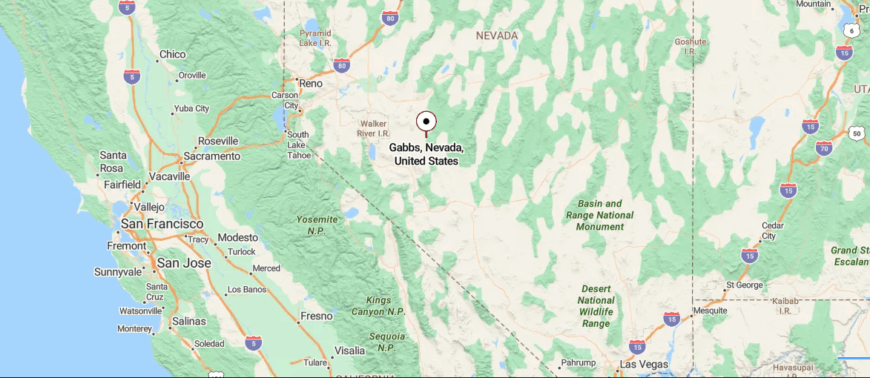
Gabbs lies in far northern Nye County, Nevada, tucked into the broad floor of Gabbs Valley beneath the Paradise Range. It sits roughly 30 miles south of U.S. Route 50 at Middlegate, reached via State Route 361—a winding route that cuts through Mineral County before dipping into Nye County.
The drive takes you across open sagebrush plains and gradually climbs through low summits before descending into the valley where the small settlement appears amid mining-era buildings. Gabbs feels quiet and remote, its hush stretched wide across open land—close enough to reach, yet distant enough to make the world seem to fall away.
14. Duckwater
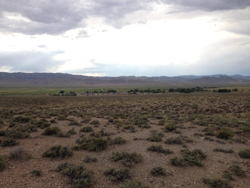
Duckwater lies deep in the remote interior of central Nevada, tucked between the Pancake and Hot Creek Ranges, where sagebrush plains roll for miles and cell signals fade into silence. Reached only by long, rugged roads far from any major highway, it feels truly off the map—quiet, self-reliant, and embraced by wilderness.
The town is home to a small, close-knit community, including the Duckwater Shoshone Tribe, where traditions are preserved in the rhythm of everyday life. Visitors might explore nearby petroglyphs, fish in local springs, hike the vast open land, or attend a tribal event if invited with care.
Ranching and tribal operations form the backbone of the local economy, rooted in the land and shaped by resilience. The air here is crisp, the nights are vast, and every sunrise feels like a private moment. It’s the kind of place that reminds you seclusion can be sacred.
Where is Duckwater?
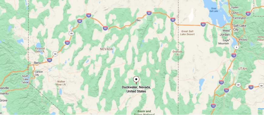
Duckwater sits quietly in the central part of Nye County, Nevada, nestled in the Duckwater Valley at the eastern edge of the Duckwater Shoshone Reservation at about 5,480 feet elevation. It lies roughly 47 miles southeast of Eureka and about 193 miles north of Las Vegas, reached via State Route 379 that branches off U.S.
Route 6 at Currant and winds into the valley. The drive traces a two‑lane road through sagebrush desert and past geothermal springs before arriving at the small settlement. Duckwater feels tucked away in a high‑desert world of stillness—accessible, yet removed enough that time almost seems to pause.
13. McGill
🔥 Would you like to save this?
McGill rests quietly in Steptoe Valley, shadowed by the Egan Range and buffered by miles of high desert that keep it gently removed from the modern world. Once a bustling copper smelter town, it now feels hushed and storied.
Though just north of Ely, McGill feels apart, shaped more by memory than momentum. Visitors can tour the preserved McGill Drugstore Museum, fish at nearby reservoirs, explore old mining relics, or walk beneath the vintage streetlights that still glow at dusk.
Some residents work in Ely or with the remaining industries tied to mining and the land, while others stay for the peace and the sense of history layered in every wall. The air is dry, the sky wide, and the pace unwavering. It’s the kind of place that reminds you how the past can linger—quietly, beautifully, and without apology.
Where is McGill?

McGill sits along U.S. Route 93 in northeastern Nevada’s White Pine County, tucked into the wide floor of Steptoe Valley just 13 miles north of the larger town of Ely. The town grew in the early 1900s as a copper-smelting center for nearby mines, reached by the same highway and a short branch road into its modest grid of streets.
The drive feels gradual and open—past sagebrush fields and low mountain ridges until McGill emerges as a legacy of industry and quiet residential life. Though reachable in under twenty minutes from Ely, McGill sits quietly in the valley, its historic depot and drugstore museum framed by distant ranges—close to a road, but tucked away in stillness.
12. Ruth

Ruth lies tucked into a high desert basin beneath the shadow of the Robinson Mine, surrounded by ridgelines and sage-covered hills that seal it off from the hum of modern life. Just west of Ely, it’s close in distance but far in feeling—quiet, tight-knit, and shaped by the rhythm of the land and the mine that has come and gone over the decades.
Rows of modest homes sit against a backdrop of open sky and rust-colored rock, where history is etched into foundations and fences. Visitors come to photograph the mining-era buildings, explore nearby trails in the Egan Range, visit the open pit overlook, or simply watch the light shift across the basin at sunset.
Mining still underpins local life, but Ruth’s spirit lives in its stillness and strength. Time here moves like dust in the wind—steady, unhurried, and rooted. It’s the kind of place that reminds you how deeply a town can be shaped by the earth beneath it.
Where is Ruth?

Ruth lies in White Pine County, tucked into Steptoe Valley just about 8 miles northwest of Ely, alongside U.S. Route 50 beneath the looming tailings of the massive copper pits. Founded in 1903 as a company town for the Robinson Mine, it once housed over 2,200 people until the mines and townsite were relocated to accommodate expanding open‑pit operations.
You arrive via Highway 50, then follow a short paved spur that climbs gently into a scrub‑scaped desert plateau edged by copper tailings. Ruth feels both industrial and silent—with heavy machinery’s scars under wide sky, close to the road yet distant from the world beyond the pit.
11. Cherry Creek
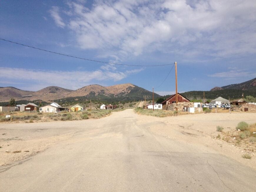
Cherry Creek sits quietly at the foot of the Schell Creek Range, hidden deep in northeastern Nevada where dirt roads stretch for miles before reaching its scattered homes and sun-faded ruins. Once a thriving mining town, it’s now barely more than a whisper—surrounded by sagebrush, cottonwoods, and the silence of high desert air.
Its isolation is complete: no services, no through-traffic, just the occasional breeze through rusted fences and the call of hawks overhead. Visitors walk among historic stone buildings, hike nearby canyons shaded by pines, photograph the old cemetery, or camp under stars so bright they seem to rest on the mountains themselves.
A handful of residents remain—ranchers, off-gridders, and those drawn to its stubborn stillness. The past lingers in every weathered board and overgrown path. It’s the kind of place that reminds you just how far a place can retreat—and still hold meaning.
Where is Cherry Creek?
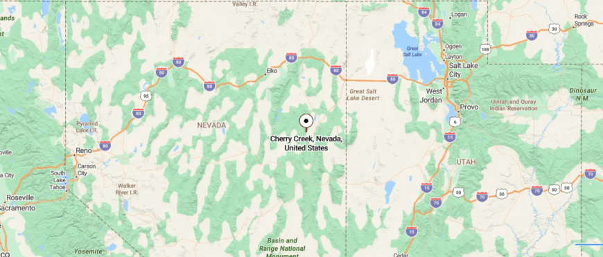
Cherry Creek is tucked into northern White Pine County in northeastern Nevada, resting on the wide floor of Steptoe Valley between the Schell Creek and Cherry Creek mountain ranges. It lies about 45 miles north of Ely, reachable via U.S. Route 93 before turning onto a paved county road that climbs gently into the valley west of the highway.
The road narrows and the landscape opens into quiet old buildings and mining ruins that feel both weathered and waiting. Cherry Creek feels suspended between mountain and desert silence—reachable, yet distant enough to seem untouched by time.
10. Lamoille
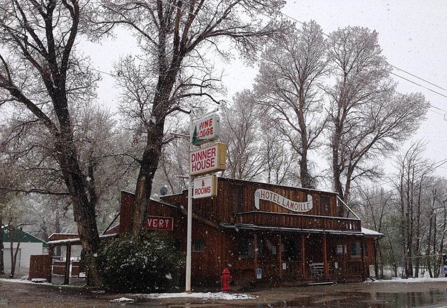
Home to about 105 residents, Lamoille sits at the mouth of glacier-carved Lamoille Canyon, often called Nevada’s Yosemite for its sheer granite walls and aspen-lined creeks. Visitors hike the Island Lake trail, watch fall colors blaze along the scenic byway, or grab dinner at the 1903-built Pine Lodge.
Ranching dominates local livelihoods, with irrigated hay fields and horse pastures stretching toward the Ruby Mountains. Although Elko lies only 15 miles away, the high peaks block cell signals and turn the village into its own quiet pocket once dusk falls.
The absence of stoplights, a one-room post office, and a white-steepled chapel underscore how little outside bustle seeps in. Nights bring clear, star-thick skies undimmed by urban glow.
Where is Lamoille?

Lamoille rests in northeastern Nevada’s Ruby Valley, reached by driving east from Elko on NV-227 until pavement narrows beneath cottonwoods. Granite spires rising to 11,000 feet seal the canyon on three sides, leaving only one road in and out.
Winter storms often close that route, adding a seasonal layer of solitude. Travelers rely on Elko for supplies before winding into this alpine pocket.
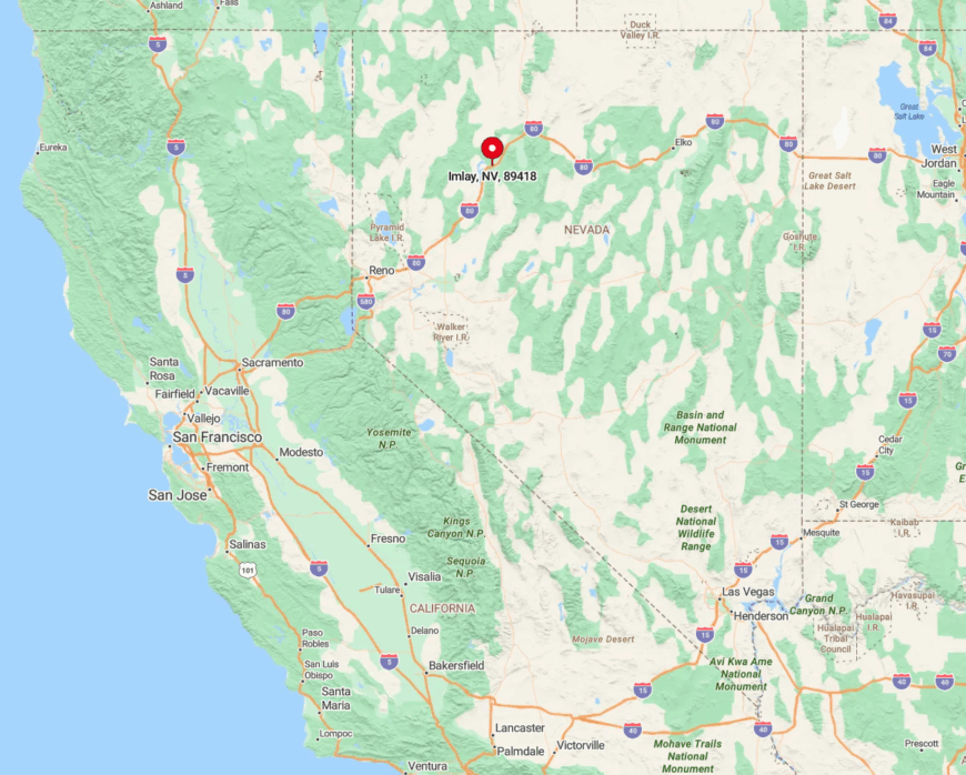
9. Imlay

Roughly 190 people call Imlay home, their main landmark the whimsical Thunder Mountain Monument—a maze of bottle-and-concrete folk art built by a self-taught sculptor in the 1970s.
Road-trippers snap photos of the monument, explore basalt buttes laced with wildflowers, or nurse a milkshake at the century-old gas station turned diner. Rail maintenance and small-scale ranching provide most paychecks, while passing trains add the only regular rumble.
The town’s flat plain stretches twenty miles in every direction, and nightfall often comes without a single car headlight on the horizon.
Side streets remain gravel, and abandoned storefronts with faded signage remind visitors how remote commerce can be. Imlay’s big sky and near-total hush earn it a place on any list of Nevada hideaways.
Where is Imlay?
🔥 Would you like to save this?
Set along Interstate 80 between Winnemucca and Lovelock, Imlay proves that a highway address doesn’t guarantee company. Leave the freeway and you’ll find no services for 35 miles west or east, just open desert and the Humboldt Range far off.
Amtrak’s California Zephyr whistles past, but only freight stops here, emphasizing the outpost vibe. Reaching town is easy; deciding to stay a while is what grants the deeper sense of seclusion.
8. Unionville
Unionville’s population hovers near twenty, yet the hamlet once hosted a young Mark Twain who mined silver here in 1862 and later immortalized the valley in Roughing It.
Today guests tour Twain’s restored stone cabin, sip cider from backyard orchards, and bed down at the Old Pioneer Garden Inn where peacocks roam under cottonwoods. Hobby ranching and a trickle of heritage tourism keep the lights on, but no commercial district survives.
Nestled in a narrow gulch of the Humboldt Range, Unionville enjoys natural barricades that muffle outside noise and limit cellular reach.
The single-lane main street ends in sagebrush, and only the sound of Willow Creek accompanies nightly stargazing. Its forgotten-by-time charm lures artists and writers seeking undisturbed focus.
Where is Unionville?

Unionville hides 17 miles south of I-80; travelers exit at Mill City and follow a winding county road past open range gates. Once the pavement ends, gravel curves into the canyon and climbs toward the old mill foundations.
Snow or heavy rain can render the road impassable, further sealing off the settlement. The nearest grocery store sits nearly an hour away in Winnemucca, a detail locals plan around carefully.
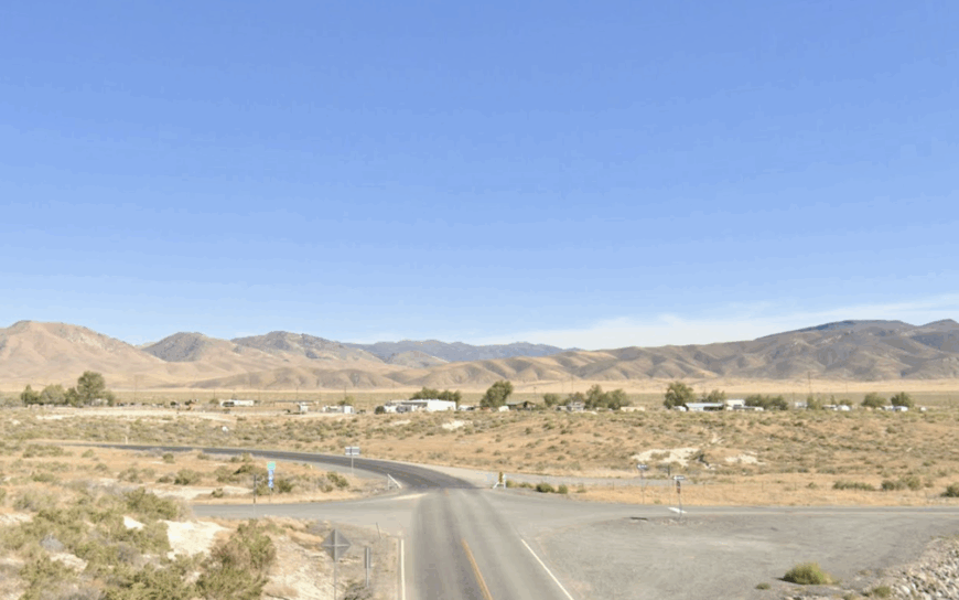
7. Ruby Valley
Scattered ranch houses spaced miles apart give Ruby Valley an unofficial count of about 150 folks spread across a 50-mile basin. Birders flock to the Ruby Lake National Wildlife Refuge for trumpeter swans and spring pelican migrations, while anglers cast for trout in the glass-calm marsh.
Cattle still outnumber people, and hay meadows stretch beneath the snow-tipped Ruby Mountains that inspired the basin’s name. Isolation comes naturally here—the valley floor is so broad that sunrise and sunset feel like private showings on a personal IMAX screen.
With no town center, residents gather at the volunteer fire hall or the tiny K-8 school when community news needs sharing. Even the mail truck shows up only three times a week.
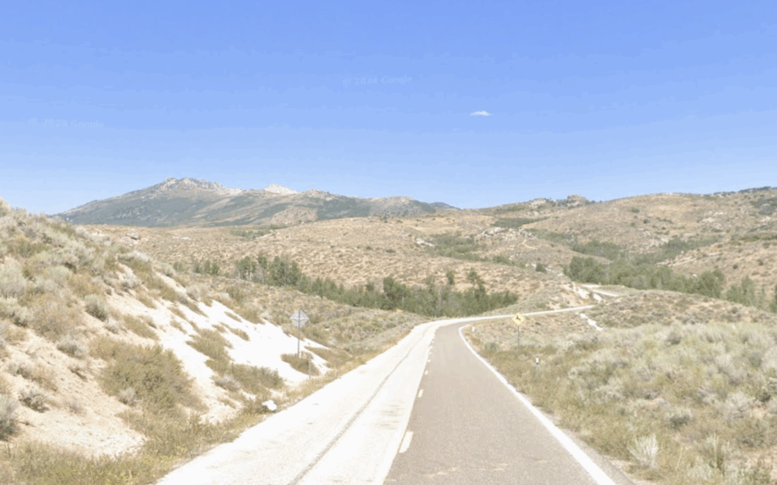
Where is Ruby Valley?
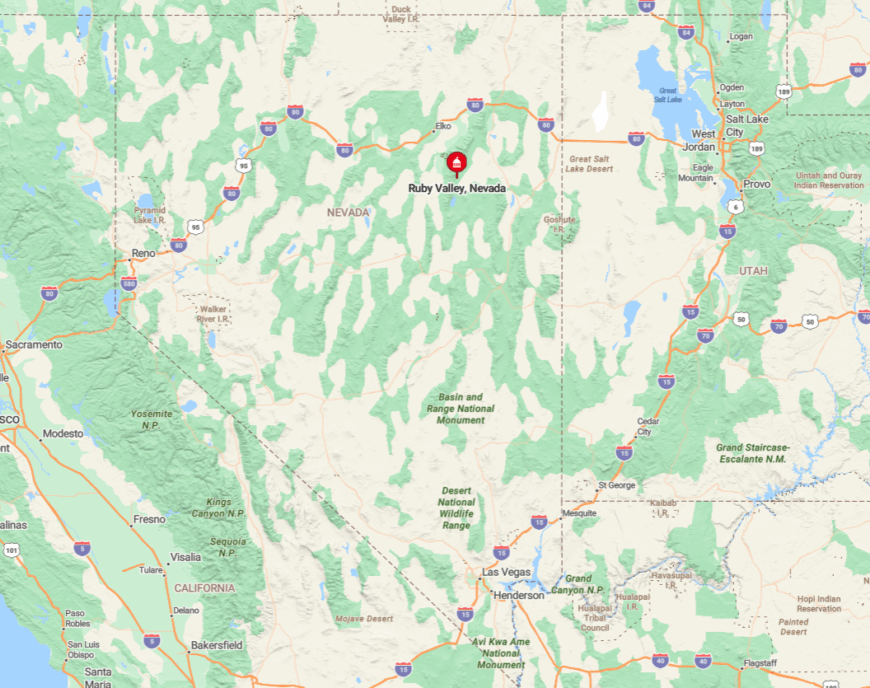
The basin lies southeast of Elko, reached by crossing Secret Pass then dropping onto NV-229 before turning onto a well-graded gravel road. Mountain walls and wetlands on either side prevent through-traffic; anyone arriving here intends to.
Fuel and cell service disappear after leaving US-93, so travelers top off tanks in Wells or Ely. In winter, blowing snow can close the pass, leaving the valley as quiet as the frozen lakes it shelters.
6. Montello

Fewer than 70 residents keep Montello alive, most of them descendants of railroad or ranch families whose roots date back to 1904. Visitors pop into the Cowboy Bar & Café for a burger, photograph rusting steam-era water towers, or explore petroglyph sites in the nearby Toano Range.
Union Pacific still sends maintenance crews here, and modest cattle outfits ring the town on five-acre parcels. Montello’s hush stems from its setting in the flat Pilot Valley, 30 miles from the interstate and far from any chain store glow.
Freight horns provide the only rush-hour soundtrack, and tumbleweed often outnumbers vehicles on Front Street. The result is a rail ghost town that never completely gave up the ghost.
Where is Montello?
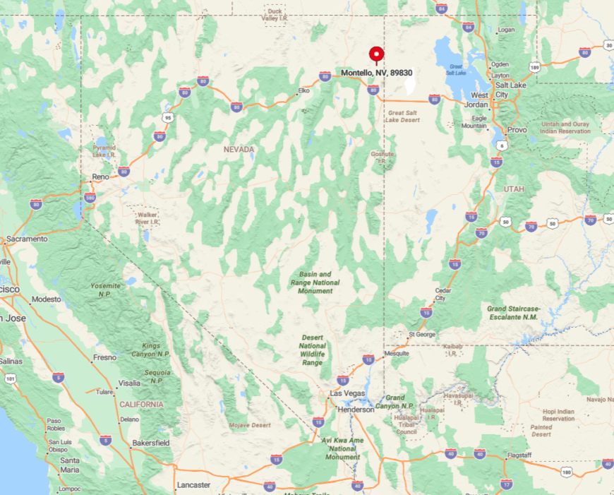
Montello lies on NV-233, a two-lane spur stretching northeast from Wells toward the Utah border. The road narrows and loses traffic the farther you go, and sagebrush soon crowds both shoulders.
Only one paved route enters town; the others are dirt tracks best attempted with high clearance. The remoteness becomes obvious when you realize the next gas pump east sits 80 miles away in Snowville, Utah.
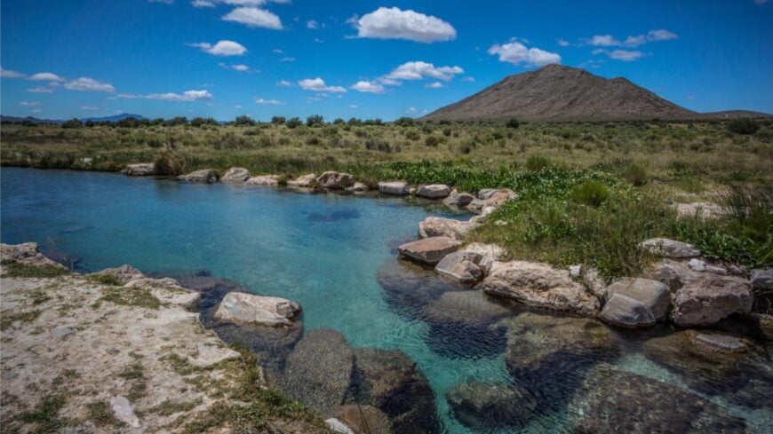
5. Denio
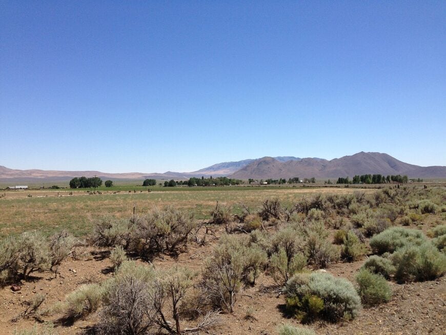
Denio claims fewer than 50 full-time residents spread between the “town” and Denio Junction, a gas station and motel five miles south. Day visitors hunt for black opals at Virgin Valley mines, soak in the steamy Borax Lake hot spring, or spot pronghorn in the vast Sheldon National Wildlife Refuge.
Ranching dominates paychecks, though seasonal rockhounds bring a brief uptick in trade. Set on the Nevada-Oregon line, Denio’s sweeping vistas make neighbors feel continents away.
With just a handful of buildings and an abandoned airstrip, silence wraps the settlement like a blanket. Even the stars seem brighter here, unobstructed by any artificial glow for more than a hundred miles.
Where is Denio?
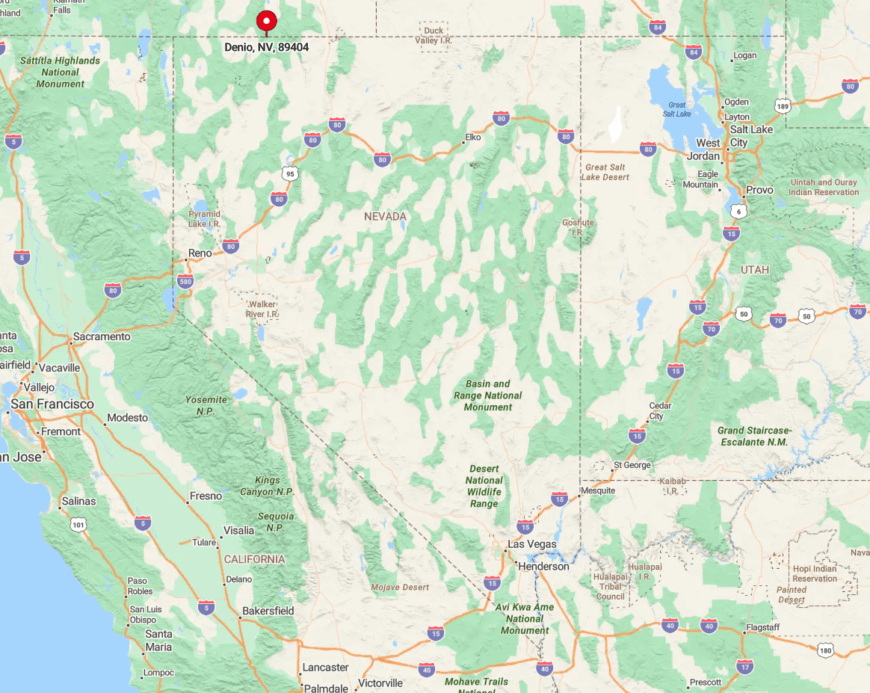
Reach Denio via NV-140, a ribbon of pavement that crosses 150 empty miles between Winnemucca and Lakeview, Oregon. Cell towers vanish halfway, and winter storms can close the highway for days.
Gravel ranch tracks and the long-abandoned railroad grade form the only side roads. Travelers plan fuel at Denio Junction, the last pump for 100 miles in any direction.
4. Paradise Valley
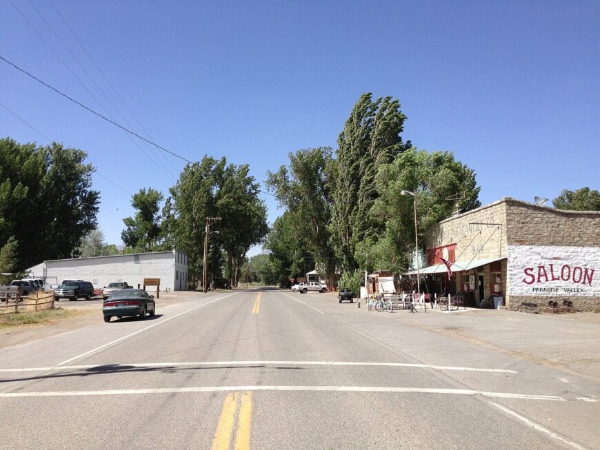
About 120 residents share this cottonwood-lined oasis framed by the snowy Santa Rosa Range and irrigated by the Little Humboldt River. Anglers cast for trout in the river bends, history buffs tour an 1879 stone church, and photographers capture red barns against golden alfalfa fields.
Cattle and hay keep the local economy afloat; the one-room schoolhouse doubles as a community center on Saturday nights. No streetlights pierce the darkness, and the nearest traffic signal sits 40 miles south in Winnemucca.
Dirt lanes extend from the paved main street, dead-ending at creek crossings or ranch gates. It’s the sort of place where a passing vehicle still draws residents to their porches just to see who’s coming through.
Where is Paradise Valley?
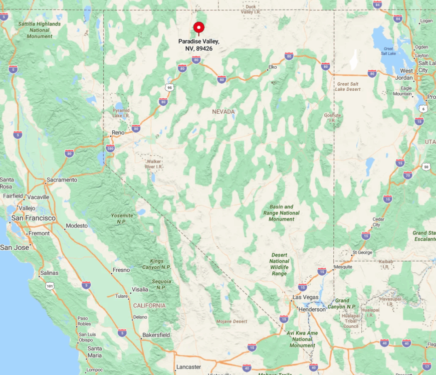
The valley begins where NV-290 leaves US-95 and winds north through sagebrush before slipping into a narrow canyon. Rock walls quickly block cell reception, heightening the sense of stepping away.
Snowmelt can flood the final miles in spring, limiting access to four-wheel-drive trucks. Stock up in Winnemucca; the last convenience store closed here in the 1990s.
3. Tuscarora
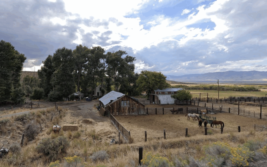
Tuscarora counts no more than 60 year-round inhabitants, many of them artists drawn to the high-desert light and the renowned Tuscarora Pottery School. Guests enroll in summer ceramics workshops, scout for obsidian spear points on nearby ridgelines, or hunt chukar along the volcanic hills come fall.
Ranching remains a secondary income stream, with small cattle herds grazing on one-acre allotments that ring the hamlet. The village’s dirt lanes, adobe kilns, and lack of cell service keep modern chatter to a minimum.
Sunsets stretch unbroken across 360 degrees of sagebrush, and the Milky Way regularly steals the show after dark. Life here moves to the rhythm of the kiln firing schedule and the seasons rather than any clock tower.
Where is Tuscarora?
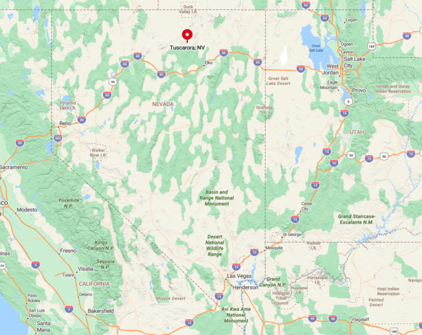
From Elko, drivers head north on NV-225, then branch onto a well-graded but isolated stretch of NV-226 for 25 miles until gravel takes over the final approach.
Snow drifts can stack six feet deep on this plateau, at times cutting the community off for days. With no stores or fuel, visitors must arrive self-sufficient. The nearest paved alternate exit sits 40 miles away, reinforcing why Tuscarora has stayed off most maps.
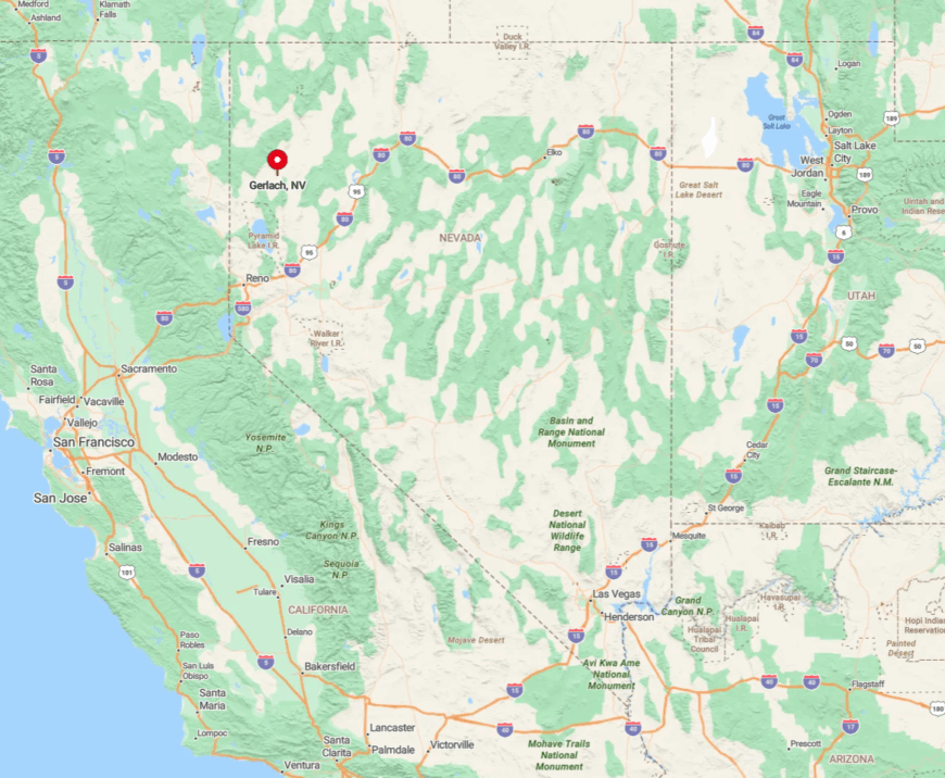
2. Gerlach
Approximately 130 hardy souls keep Gerlach ticking, their daily backdrop the endless alkali flats of the Black Rock Desert.
Daytime options include soaking in Soldier Meadows hot springs, exploring Fly Canyon’s wind-carved tunnels, or sharing a plate of ravioli at Bruno’s Country Club—a bar-restaurant that has fed travelers since 1952. A nearby gypsum mine and seasonal tourism linked to the Burning Man festival supply most jobs.
Outside those dusty weeks, Gerlach slips into near silence, with the playa’s mirage-shimmering emptiness amplifying every coyote howl. Storefronts date to the 1920s, and the single gas pump often closes by early evening. One step off Main Street and you’re in a 200-square-mile void where tire tracks vanish with the next gust.
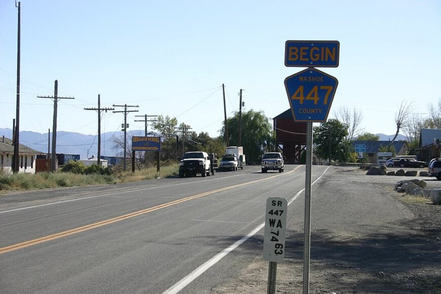
Where is Gerlach?
Gerlach sits 100 miles north of Reno via NV-447, the only paved route linking it to the outside world. The two-lane highway passes Pyramid Lake before losing cell coverage roughly halfway, underscoring the growing distance from city life.
Storms can turn the playa into impassable muck, sealing Gerlach off except by air. Travelers time fuel stops carefully; the next gas in any direction is at least 70 miles away.
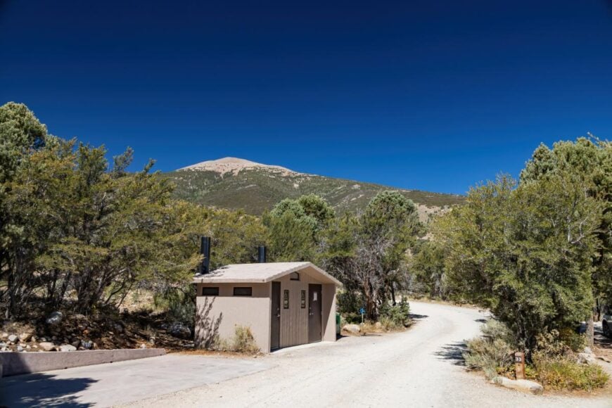
1. Jarbidge
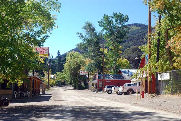
Fewer than 75 people occupy Jarbidge, a former gold-rush boomtown tucked in a river canyon of the same name. Summer visitors hike the Jarbidge Wilderness, fly-fish the icy creek for red-band trout, or sip a cold one at the Red Dog Saloon—one of Nevada’s highest-elevation bars.
Tiny guesthouses and a U.S. Forest Service station form the main employers, supplemented by seasonal hunting guides chasing elk and mule deer. Sheer cliffs and 10,000-foot peaks hem the community on all sides, and the last 20 miles of unpaved road discourage casual passersby.
Store hours depend on whether the proprietor feels like opening, and mule deer often outnumber headlights after dark. The result is a frontier vibe that feels more 1910 than 2024.
Where is Jarbidge?
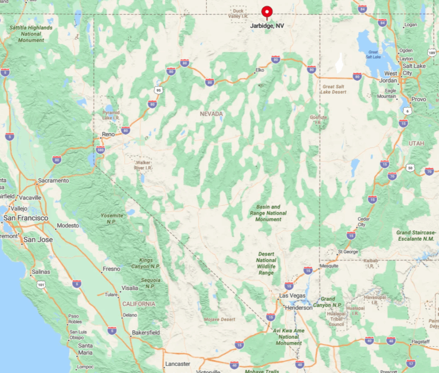
Jarbidge lies in Nevada’s extreme northeast corner, 80 road miles from the nearest stoplight—over half of them dirt—whether coming south from Idaho’s Rogerson or north from Elko County’s Jackpot.
High mountain passes close under deep snow each winter, leaving snowmobiles and horseback as the only ways in or out until late spring. GPS often loses signal in the canyon, so paper maps remain wise companions.
Those who brave the trek find a road-end frontier where silence is broken only by the river and maybe a distant chainsaw clearing next winter’s firewood.