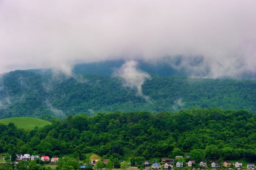
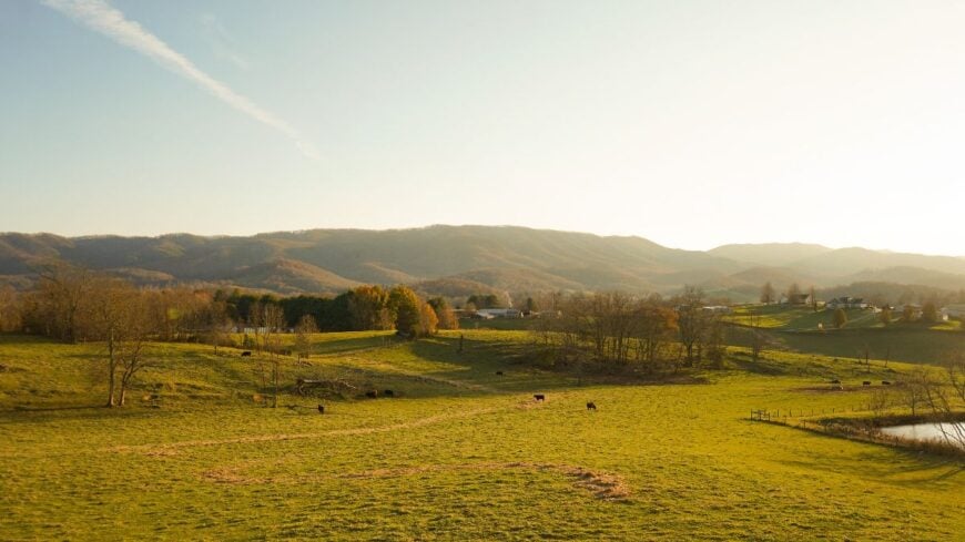
Western Virginia hides pockets of mountain life where ridgelines muffle highway noise and porches look out on more cattle than cars. We gathered 25 such hamlets that still greet travelers by first name, each with its own landscape, local flavor, and quiet pace.
In order to come up with the very specific design ideas, we create most designs with the assistance of state-of-the-art AI interior design software.
From high plateaus brushed with spruce to bowl valleys shielded by four thousand foot peaks, these places share a common gift: distance. We invite armchair explorers and relocation daydreamers alike to picture drives without billboards, trout streams free of crowds, and night skies bright enough to navigate by starlight.
The list begins in Highland County and counts down to a Roanoke Valley hideaway, proving that solitude can survive even near a city. Pack curiosity, slow down, and meet the mountain towns that keep Western Virginia’s hush intact.
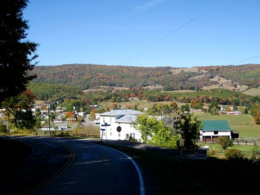
25. Glen Lyn, Giles County
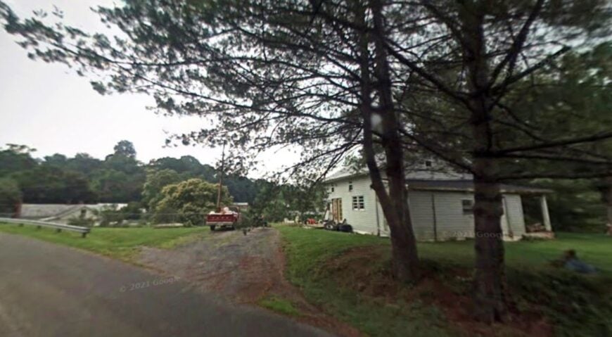
Glen Lyn, perched on a bend of the New River in Giles County, feels more like a hidden riverside hollow than a town. With fewer than 150 residents, its pace mirrors the slow current pressing between steep wooded ridges. Old clapboard houses and fading docks speak of an industrial past that has long slipped downstream.
Life now revolves around the river itself. Locals fish quiet pools, launch kayaks, and picnic at the small town park where the water glints beneath sandstone bluffs. The hush of the gorge makes even weekend visitors seem few, and the rhythm of outdoor life outpaces any hint of commerce.
Logging once cut the hills bare, but the return of forest has brought a sense of pause. At dusk, when mist rises from the water, Glen Lyn feels suspended—secluded not only by geography but by the memory of a life that moved more slowly.
Where is Glen Lyn?
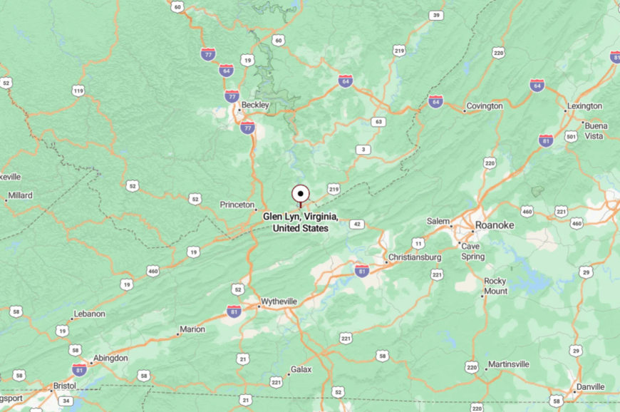
Glen Lyn sits in far western Giles County, just two miles from the West Virginia line. It lies about 30 miles northwest of Blacksburg, reached by following U.S. 460 through a narrowing river gorge.
The journey winds past forests and bluffs, with the road pressed tight against the New River. Arriving feels like slipping into a hidden pocket carved out of the mountains.
24. Cripple Creek, Wythe County
Cripple Creek hides in a winding valley that feels more Appalachian hollow than open settlement. A scattering of farms and cabins stretches across meadows, and the narrow creek gurgles past old mill sites long abandoned. Its name comes from the historic mining days, though now the area’s spirit is pastoral and quiet.
Anglers chase stocked trout in the creek, while hikers slip into surrounding forest trails that climb toward Iron Mountain. The handful of residents live by farming, timber work, or simply retirement in peace.
The quiet is broken only by birdsong and the distant lowing of cattle. It’s the kind of place where you notice the sound of the wind before you notice any traffic.
Where is Cripple Creek?
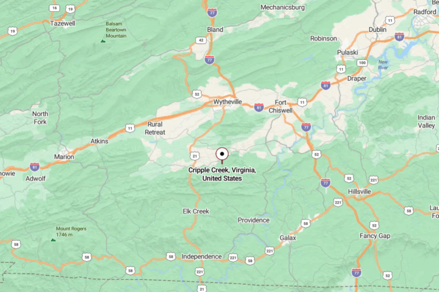
This secluded hamlet lies in Wythe County, tucked south of Rural Retreat and hidden along Virginia Route 94. The drive follows two-lane backroads that hug hillsides and cross one-lane bridges.
Interstate 81 is just 15 miles east, but it feels far removed once you reach the valley. The setting is so hushed that time seems to slow with every bend in the creek.
23. Mouth of Wilson, Grayson County
Mouth of Wilson sits where Wilson Creek pours into the New River, tucked into the far southwest corner of Grayson County. It isn’t a place you stumble upon easily—just a cluster of homes, a small school, and riverside farms pressed into a bend of water and hills. The landscape closes in like a natural cul-de-sac, giving the village an enclosed, self-contained feel.
The draw here is the outdoors. Anglers cast into the New River’s broad current, while hikers climb into Grayson Highlands State Park to spot the famous wild ponies or follow trails into the high country of Mount Rogers. White Top Laurel Creek and other feeder streams lace the hillsides, offering quiet escapes that match the town’s slower pace.
Life remains tied to farming and forestry, with the sound of livestock or a chainsaw more common than traffic. At sunset, when fog drifts across the river, Mouth of Wilson feels like a place apart—secluded by both its geography and its rhythm of life.
Where is Mouth of Wilson?
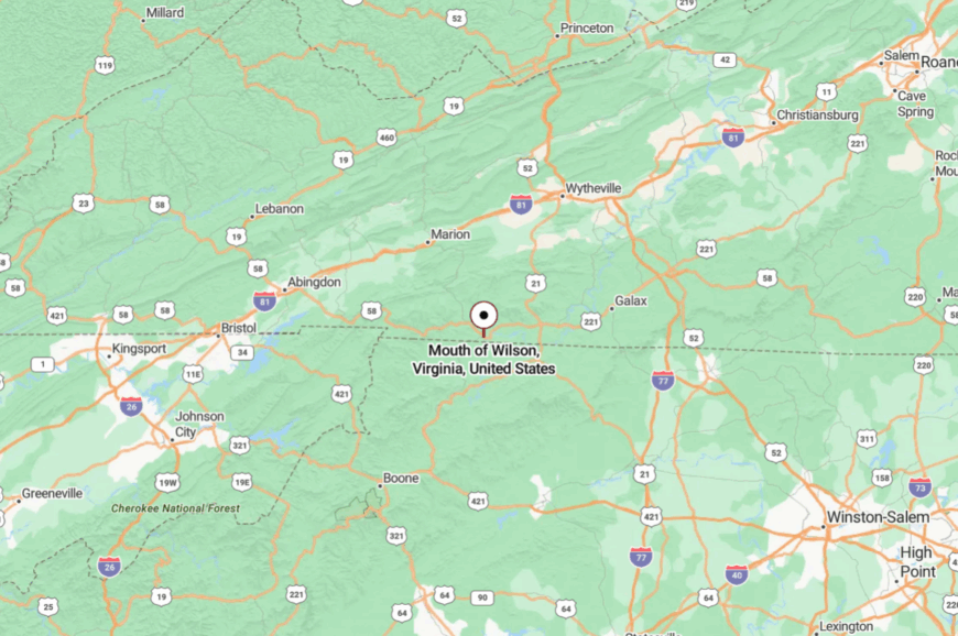
This village rests in extreme southwest Grayson County, less than ten miles from the North Carolina border. It’s about 45 miles west of Galax, reached only by U.S. Route 58 or winding county roads.
The trip involves crossing wooded ridges and following the river’s bends, making the arrival feel tucked away. Once there, the river’s steady current seems to mark the only passage of time.
22. Bolar, Highland County
Bolar isn’t so much a town as it is a cluster of farms in a high Highland County valley, but that’s exactly what makes it feel hidden. Settlers’ cabins still stand beside hay meadows, and sheep graze across rolling hills that look untouched by modern life.
The air is filled with the scent of spruce from nearby ridges, and the sound of bleating flocks carries farther than cars ever do. Visitors pass through on the way to fishing creeks or to hike in the George Washington National Forest, yet few ever stop.
Maple syrup farms and sheep raising form the backbone of its sparse economy. Life here is measured in seasons, not minutes. Bolar whispers of Virginia’s past, as though the 19th century never quite left.
Where is Bolar?
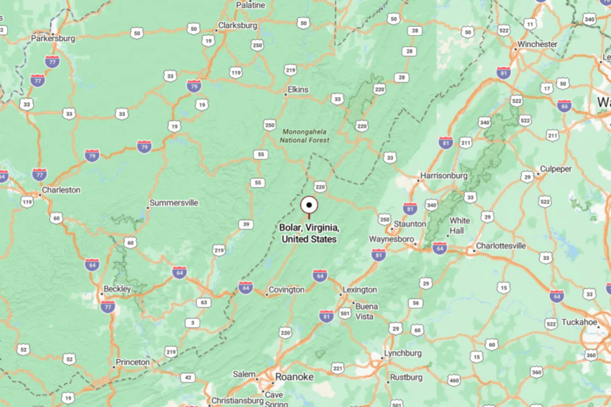
The settlement lies in Highland County near the Bath County line, perched along U.S. Route 220. It’s about 20 miles north of Warm Springs, reached via a two-lane highway that winds through forested mountains.
Traffic is light, and cell reception fades long before arrival. That sense of being cut off is precisely what makes Bolar so serene.
21. Konnarock, Washington County
Konnarock lies at the base of Mount Rogers, where rhododendron thickets crowd old cabins and creeks still gurgle beside what used to be logging camps. Once a lumber town with its own rail spur, it has settled into a scattering of homes framed by high peaks and cool mountain air that seems to muffle every sound.
Visitors come here to step into the Mount Rogers National Recreation Area, following trails that lead into spruce-fir forests or connecting to the Virginia Creeper Trail at nearby Whitetop and Damascus. White Top Laurel Creek winds close by, a clear mountain stream that still marks the footprint of the town’s timber past.
Forestry jobs have faded, replaced by seasonal hikers, weekend anglers, and a few hardy farms. The place carries a sense of seclusion that feels both vast and personal—as if the mountains are intent on keeping Konnarock’s hush intact.
Where is Konnarock?
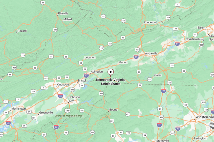
This hidden town rests in the far southwest corner of Virginia, about 25 miles southeast of Abingdon. It sits along State Route 603 at the edge of Jefferson National Forest.
Getting there involves steep climbs and switchbacks that curl around streams and mountain ridges. When you finally arrive, the peaks rise so high they block out the outside world.
20. Laurel Fork, Carroll County
Laurel Fork is the kind of mountain community where farms still line dirt lanes, and mist lingers on pastures until well into the morning. Perched on the Blue Ridge Plateau, its open hayfields stretch out like patchwork beneath long horizons.
A few general stores and a post office form the heart of town, while everything else feels scattered and self-sufficient. Visitors come to pick berries at small orchards, hike to Devil’s Den Nature Preserve, or drive the Blue Ridge Parkway nearby.
Agriculture dominates—mostly cattle, corn, and hay. Life here feels both practical and peaceful, rooted in a closeness to land. Laurel Fork invites you to slow your breath and notice the quiet.
Where is Laurel Fork?
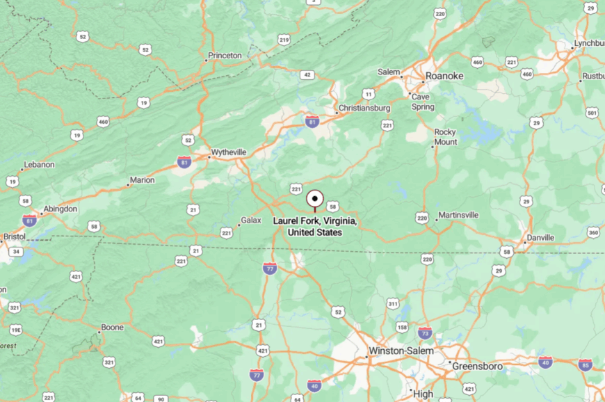
Located in Carroll County near the Patrick County line, Laurel Fork sits at about 2,800 feet on the Blue Ridge Plateau. It lies roughly 20 miles southeast of Hillsville, reached by narrow state roads that meander past farms and forests.
The Parkway skirts just west of town, but few travelers turn off to explore. For those who do, the seclusion is immediate and rewarding.
19. Saltville, Smyth County
🔥 Would you like to save this?
Saltville is steeped in history, yet feels isolated by the bowl of mountains that encircle it. Once a salt mining hub that supplied the Confederacy, the town now rests quietly with only about 2,000 residents. Its vibe is part ghostly, part small-town cozy, with historic ruins blending into the hills.
Visitors explore the Museum of the Middle Appalachians, spot rare wildlife at the Saltville wetlands, or hike the Clinch Mountain trails. A few small factories and tourism keep the town’s economy alive.
But it’s the silence of the surrounding ridges that sets the tone—Saltville feels protected by its geography, sealed off from the pace of modern highways. It’s the kind of place where history feels alive in the stillness.
Where is Saltville?
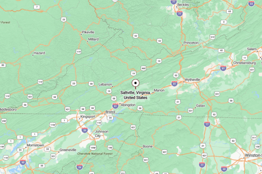
Saltville lies in Smyth County near the border with Washington County, about 15 miles northwest of Marion. It’s reached via State Route 107, a winding two-lane road that threads through narrow valleys.
Interstate 81 is close on the map, but the enclosing ridges make the town feel a world apart. Even as you approach, the land folds in around you, leaving the outside world behind.
18. Bland, Bland County
With a name that sounds plain, Bland is anything but ordinary once you see its mountain embrace. Surrounded by Jefferson National Forest, this tiny county seat feels like a mountain hollow where life still moves at the pace of the seasons.
The courthouse square is simple, the storefronts unhurried, and the mountains rise like guardians on every side. Travelers pause for Appalachian Trail access, fishing in Wolf Creek, or a plate of country cooking at the diner.
Farming and forestry support the sparse population, but much of the land is just open wilderness. Nights here are dark, and the silence almost rings in your ears. Bland is proof that quiet can be a luxury.
Where is Bland?
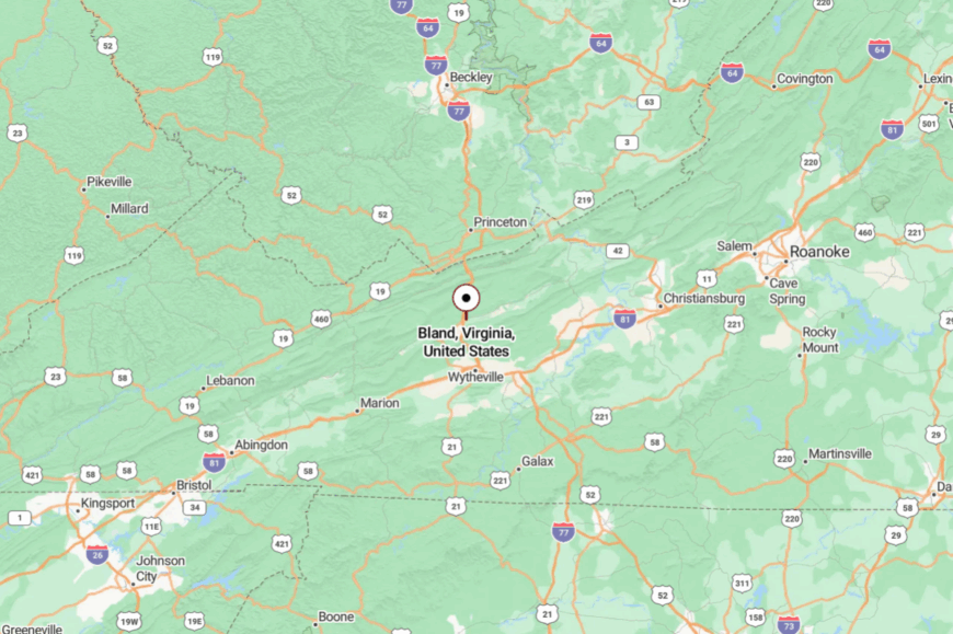
The town lies in the heart of Bland County, about 20 miles northwest of Wytheville. It’s accessible via Interstate 77 but requires turning off onto winding county roads that quickly shed the bustle of the highway.
The town sits in a narrow valley hemmed by ridges. By the time you reach it, the stillness feels complete.
17. Damascus, Washington County
Known as “Trail Town, USA,” Damascus is world-famous among hikers but still feels utterly secluded in daily life. It sits at the junction of seven trails, including the Appalachian Trail, the Virginia Creeper, and the Iron Mountain Trail.
Its vibe is outdoorsy and cheerful, with bike shops, coffeehouses, and outfitters clustered on its quiet Main Street. Visitors pedal the Creeper Trail, hike to Grayson Highlands to see wild ponies, or attend the lively Trail Days festival.
Tourism is the main economic lifeline, though the town never feels crowded outside festival weekends. Nestled in a valley of forest and streams, Damascus seems to breathe with the rhythm of boots and bikes. At dusk, when the trails are empty, the silence is astonishing.
Where is Damascus?
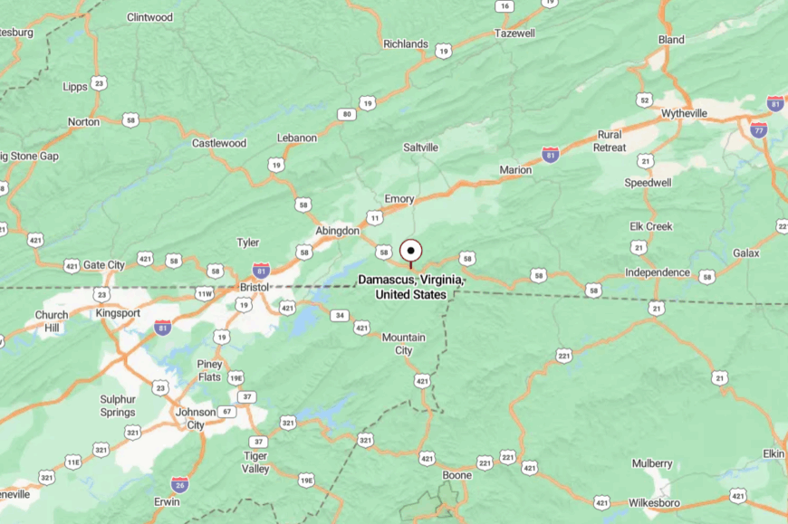
The town rests in Washington County, about 13 miles southeast of Abingdon. It’s reached by U.S. Route 58, a twisting mountain road that crosses the South Fork of the Holston River.
Although near Interstate 81, the enclosing hills make the town feel distant. Arriving, you realize the trails themselves are the lifelines in and out.
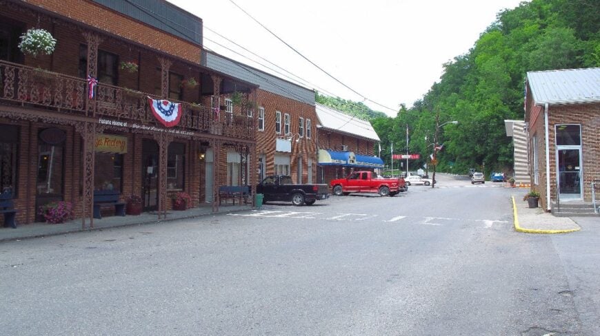
16. Big Stone Gap, Wise County
Big Stone Gap rests in a coal valley so narrow the ridges seem to press against the town. Once a bustling mining hub, it now feels slowed, with brick storefronts and an old-time charm. Its atmosphere mixes history and resilience, carried in Appalachian music, local theater, and the stories of the coal camps.
Visitors tour the Southwest Virginia Museum, hike to High Knob, or catch a play at the Mountain Empire Arts Center. While coal still shapes memory, today the economy leans on healthcare, education, and tourism.
Surrounded by highlands on every side, Big Stone Gap remains sheltered, its quiet broken only by trains echoing through the gorge. The town holds a deep, rooted stillness, like a pause between verses of a song.
Where is Big Stone Gap?
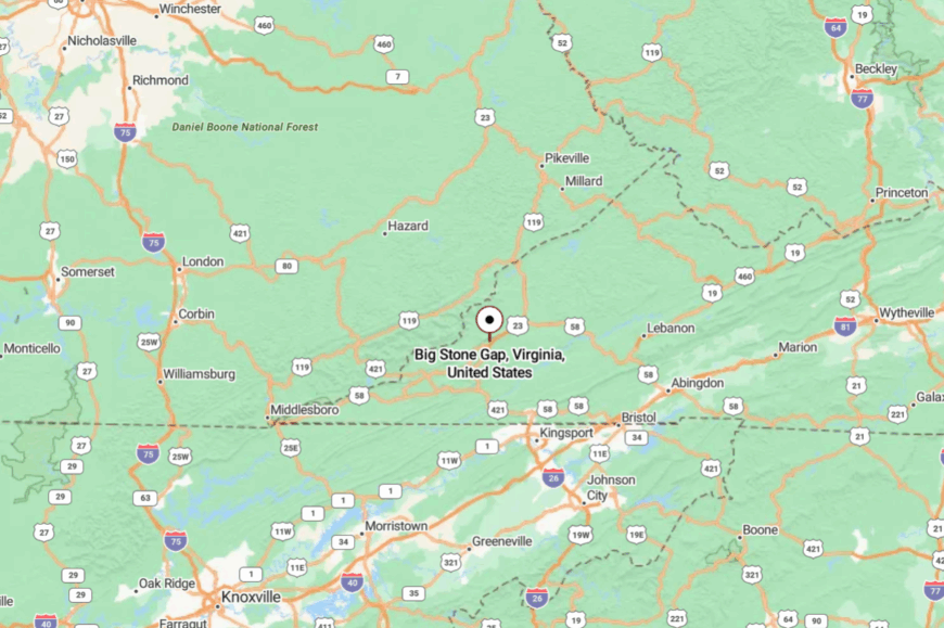
The town is located in Wise County, tucked into the far southwest corner of Virginia near the Kentucky line. It’s about 40 miles northwest of Kingsport, Tennessee, and accessible via U.S. 23.
Getting there requires weaving through long mountain valleys and climbing steep grades. The journey ends in a basin that feels both hidden and protected.
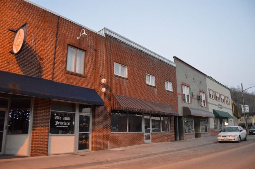
15. Haysi, Dickenson County
Haysi clings to a fork of the Russell Fork River, where steep sandstone cliffs keep it pocketed away from the wider world. With fewer than 500 residents, it feels like a mountain hollow that has simply never been opened up.
Its streets are narrow, its stores few, and the river runs like a constant pulse through town. Visitors explore Breaks Interstate Park nearby—called the “Grand Canyon of the South”—or paddle the rapids of the Russell Fork.
Coal and timber once provided most jobs, but today the economy is quieter, with tourism and small businesses keeping it afloat. The cliffs and forests lend Haysi a wild, untamed vibe. It’s a place that reminds you how deeply the mountains can shelter life.
Where is Haysi?
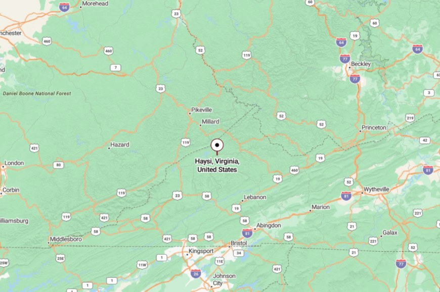
Haysi sits in Dickenson County, about 30 miles northwest of Grundy. It’s reached by U.S. 83, a winding mountain road that cuts along river gorges and ridges.
The drive feels rugged, with switchbacks and narrow shoulders hugging cliffs. When you arrive, the landscape makes clear why Haysi has remained so remote.
14. Pound, Wise County
Pound nestles in a rugged hollow of the Appalachians, its name echoing both a mining past and a hard resilience. With just over 900 residents, it feels small and quiet, a town where main street slows to a trickle of trucks and conversations.
The vibe is rustic and practical, softened by the presence of Pound Lake just outside town—a haven for fishing, kayaking, and camping. Visitors wander into Jefferson National Forest, paddle the lake, or take scenic drives into the hills.
Coal once defined its economy, but now recreation and a slower pace take its place. At night, stars reflect on the lake’s calm surface, and the mountains ring the town in silence. Pound carries the essence of Appalachia’s hush.
Where is Pound?
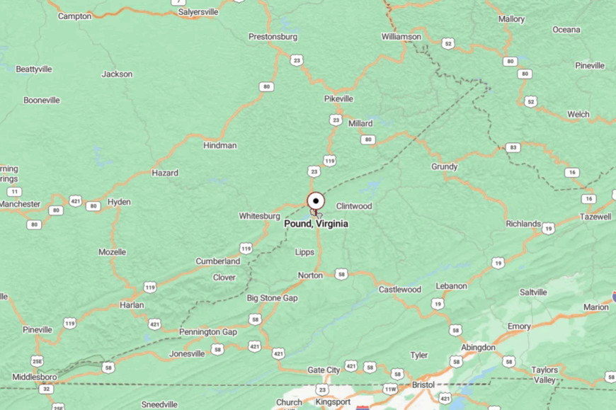
The town is located in northern Wise County, less than ten miles from the Kentucky border. It’s about 50 miles from Kingsport, Tennessee, accessible only by twisting U.S. 23 through the mountains.
The highway passes near, but the ridges keep the town feeling enclosed. To arrive is to find a pocket of stillness among sharp peaks.
13. Jonesville, Lee County
🔥 Would you like to save this?
Jonesville lies in Virginia’s farthest southwest corner, closer to Tennessee and Kentucky than any Virginia city. Its main street curves lazily through farmland, historic brick buildings, and weathered storefronts that look like something from a century past.
With fewer than 1,000 people, the vibe is neighborly, slow, and deeply traditional. Visitors explore the Lee County Courthouse, stroll shaded side streets, or drive to Wilderness Road State Park for a taste of pioneer history.
Farming and small-scale trade sustain the town, though many simply value its quiet. Surrounded by rolling hills and cradled in an isolated valley, Jonesville feels worlds away. It’s a place where life moves by handshake, not headline.
Where is Jonesville?
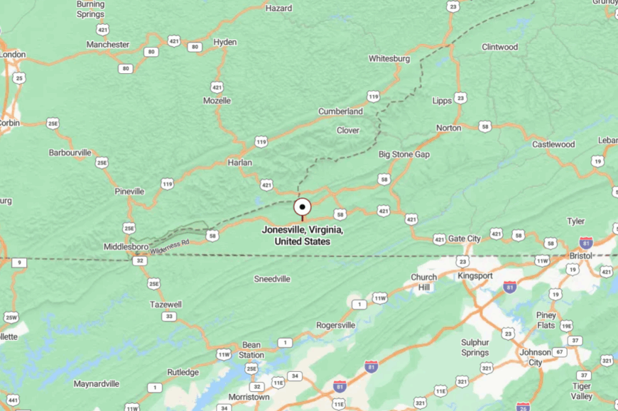
Jonesville sits in Lee County at the tip of Virginia’s southwest corner. It’s about 60 miles west of Kingsport, Tennessee, and accessible via U.S. Route 58.
The drive crosses winding mountain terrain and valleys where few cars pass. Arriving feels like stepping into a pocket of Virginia rarely seen by outsiders.
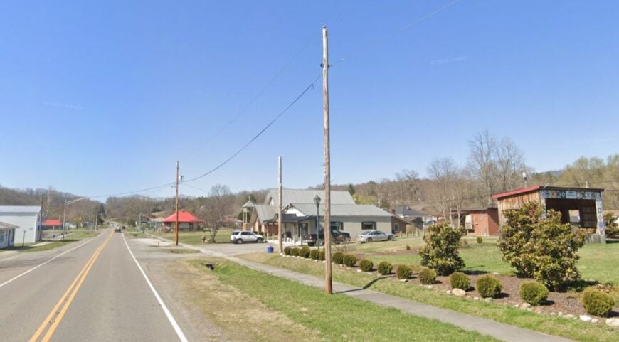
12. Clintwood, Dickenson County
Clintwood lies tucked between sandstone ridges, its downtown brick storefronts dwarfed by the green peaks rising above. Once tied to coal, today it feels more like a small mountain retreat where community ties matter more than commerce.
Its vibe is both nostalgic and resilient, carried in local diners, country music halls, and front-porch gatherings. Visitors check out the Ralph Stanley Museum, hike nearby Birch Knob, or drive winding backroads that reveal endless forest.
Though some residents still work in mining, others lean on small shops and tourism. Nights fall quickly in the shadowed valley, bringing a stillness that feels deep and protective. Clintwood holds on quietly, as if the mountains are keeping watch.
Where is Clintwood?
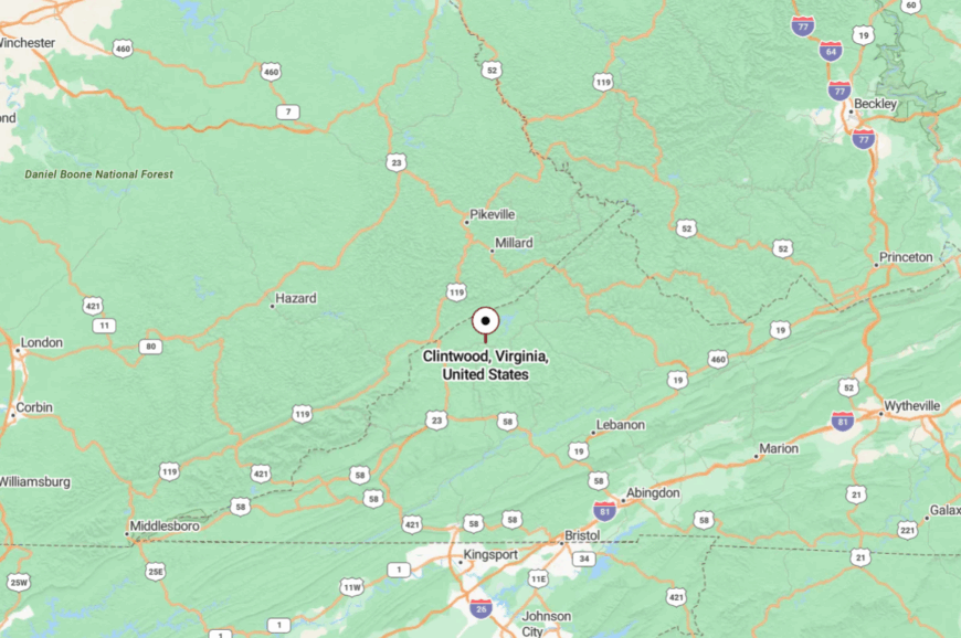
The town rests in Dickenson County, about 35 miles northeast of Norton. It’s reached via State Route 83, a twisting road that snakes through narrow hollows and ridges.
Interstate highways are hours away, making the trip slow but scenic. By the time you reach Clintwood, you understand why it feels sealed off.
11. Dungannon, Scott County
Dungannon hugs the Clinch River, a place where the water cuts through limestone cliffs and shelters rare species found nowhere else. With fewer than 300 residents, it feels like a small village hidden in a fold of the mountains.
Its vibe is rustic, river-centered, and friendly in a quiet way. Visitors fish the Clinch, hike to Natural Tunnel State Park nearby, or explore the high bluffs along the river. Farming and small-scale trade support its people, with nature itself providing the richest resource.
The river’s shimmer, the call of whip-poor-wills, and the silence of the cliffs all give Dungannon a timeless aura. It’s the kind of place where you realize how much the land shapes the soul.
Where is Dungannon?
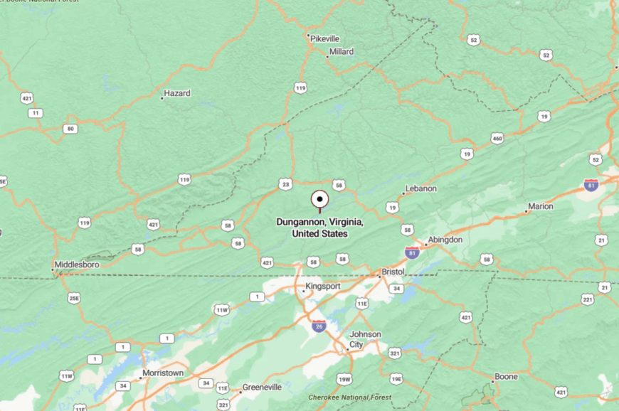
The town sits in Scott County, about 20 miles northeast of Gate City. It’s reached by State Route 65, a narrow two-lane road that follows the Clinch River valley.
No interstates come near, and the trip involves curves and crossings that slow every mile. Arriving, the river greets you like a secret revealed only to those who look.
10. Monterey, Highland County
With roughly 150 year-round residents, Monterey feels more like a friendly neighborhood than a town. Visitors come for the Highland County Maple Festival, roadside farm stands, and panoramic drives along U.S. 250 that cross Shenandoah Mountain.
Sheep herding, maple syrup production, and small hospitality businesses form the economic backbone. Hand-hewn storefronts on Main Street sell wool blankets and apple butter that are produced within sight of the shop windows.
After dark, the sky glows with stars because no large settlement sits within thirty miles. This natural buffer of ridgelines at nearly 2,800 feet keeps Monterey quietly apart from the urban swath of the Shenandoah Valley.
Where is Monterey?
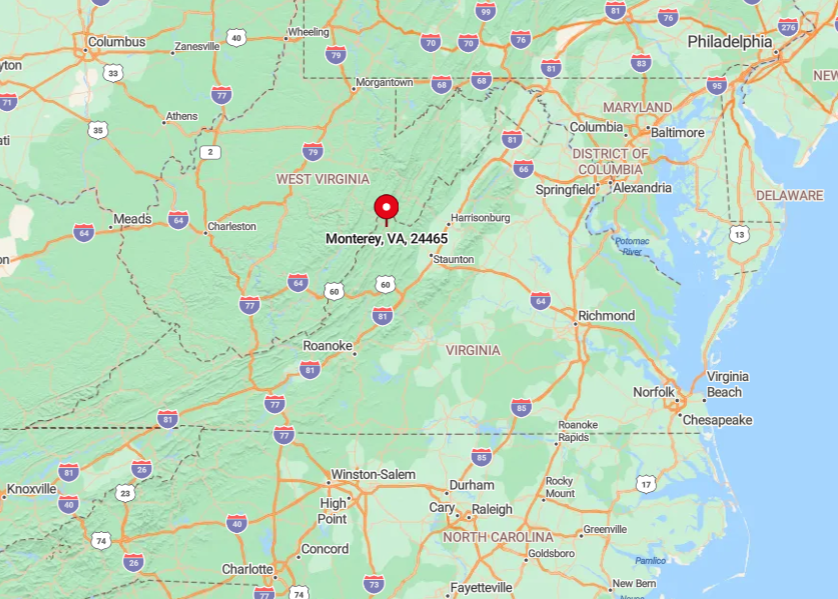
Monterey lies in the center of Highland County, just a few miles east of the West Virginia border. The town occupies a high saddle between Jack and Doe Hills, which funnels traffic to a single two-lane highway and discourages through trips.
Reaching Monterey involves climbing switchbacks on U.S. 250 or driving the lonely course of State Route 220 from Covington. The journey feels remote long before arrival since there is no cell signal for most of the last twenty minutes.
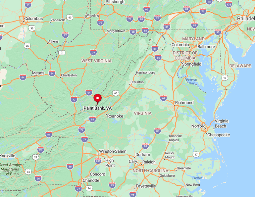
9. Paint Bank, Craig County
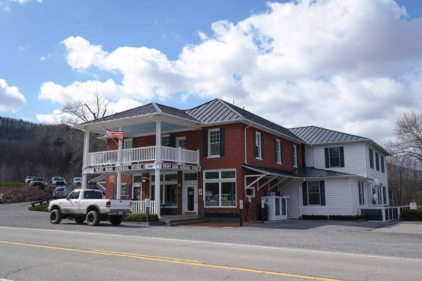
Fewer than one hundred people call Paint Bank home, yet the place radiates a frontier vibe that belies its size. Travelers stop at the red-roofed Paint Bank General Store, watch bison graze at Hollow Hill Farm, and cast lines for native trout in Potts Creek.
Small scale cattle and buffalo ranching, limited forestry, and the Swinging Bridge Restaurant support the local economy. The village sits in a fold of Jefferson National Forest, giving photographers a dramatic backdrop of hardwood ridges in every direction.
Evenings grow hushed enough to hear whip-poor-wills over the faint hum of Route 311. This cloak of forested slopes positioned forty mountain miles from the nearest city preserves Paint Bank’s seclusion.
Where is Paint Bank?
🔥 Would you like to save this?
Paint Bank rests in Craig County near the West Virginia line on Virginia Route 311. Potts Mountain rises immediately west of town, forcing any driver to wind over gaps that close after heavy snows.
The closest interstate is I-64, a half-hour north through Sweet Springs, and GPS signals often fade on the climb. Most visitors arrive from Roanoke via a one hour drive that feels longer due to the continual hairpin turns.
8. Burkes Garden, Tazewell County
Burkes Garden counts barely three hundred residents scattered across a wide, bowl-shaped valley locals nickname God’s Thumbprint. Cyclists ride the loop road, hikers branch onto the Appalachian Trail at Walker Gap, and hungry travelers hunt down strudel at the Amish bakery near the old post office.
Hay, beef cattle, and farmstead cheese dominate the modest economy, with several families still using horse drawn equipment. Weathered barns and open meadows sit 3,000 feet above sea level, surrounded by a perfect ring of 4,700 foot peaks.
No commercial signage interrupts the view, and streetlights are absent altogether. Only a single switchback road climbs the rim, ensuring Burkes Garden remains as quiet as it was a century ago.
Where is Burkes Garden?
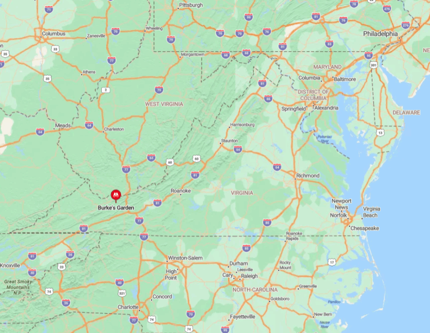
The valley lies in Tazewell County, five miles north of the town of Tazewell as the crow flies. Because mountains wall it off on every point of the compass, radio and cell coverage seldom penetrate the basin.
Virginia Route 623 connects Burkes Garden to VA 42 with five sharp hairpins that challenge larger vehicles. Arrivals who brave the grade are rewarded with a panorama few tourists ever witness.
7. Whitetop, Grayson County
Whitetop shelters roughly one hundred fifty residents along the highest reaches of Grayson County. Outdoor enthusiasts tackle the last climb to Whitetop Mountain, pedal the Virginia Creeper Trail starting at the old railroad depot, and pick out fresh Fraser firs from family Christmas tree farms.
Tree farming, modest logging, and seasonal recreation dollars circulate through the community. Abandoned rail trestles and mist drifting through spruce stands give the landscape a northern feel rare in Virginia.
Most homesteads sit on acre lots or larger, separated by tangled rhododendron and gravel lanes. Limited services and the second highest summit in the state combine to keep Whitetop secluded.
Where is Whitetop?
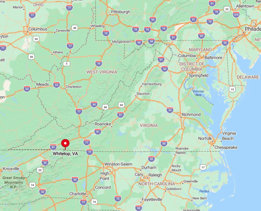
The settlement clings to the slopes where Washington and Grayson counties meet, just south of Route 58. Mountain shoulders block direct access, so every approach involves a series of narrow roads that top out near 5,000 feet.
From Interstate 81 at Chilhowie, drivers wind more than thirty miles through Laurel Valley before reaching the crest. Snowfalls can close the route for days, contributing to the hamlet’s isolation.
6. Sugar Grove, Smyth County
Roughly 650 people live in Sugar Grove, a quiet hollow along Fox Creek in Smyth County. Visitors step off the Appalachian Trail for a slice of pie at the old general store, angle for native brook trout in shaded pools, or camp beneath hemlocks at Hurricane Campground.
Family farms, a woodworking shop, and trail-related services keep the modest economy running. A single white church steeple rises above clapboard cabins, while ridges of Jefferson National Forest press close on every side. The result is a skyline of barns and forest rather than pavement and lights.
Once you leave the last four-lane road behind, the approach feels like a gradual retreat from the outside world. Narrow mountain routes, fading cell reception, and the hush of the forest combine to make Sugar Grove feel more insulated than its map location might suggest.
Where is Sugar Grove?
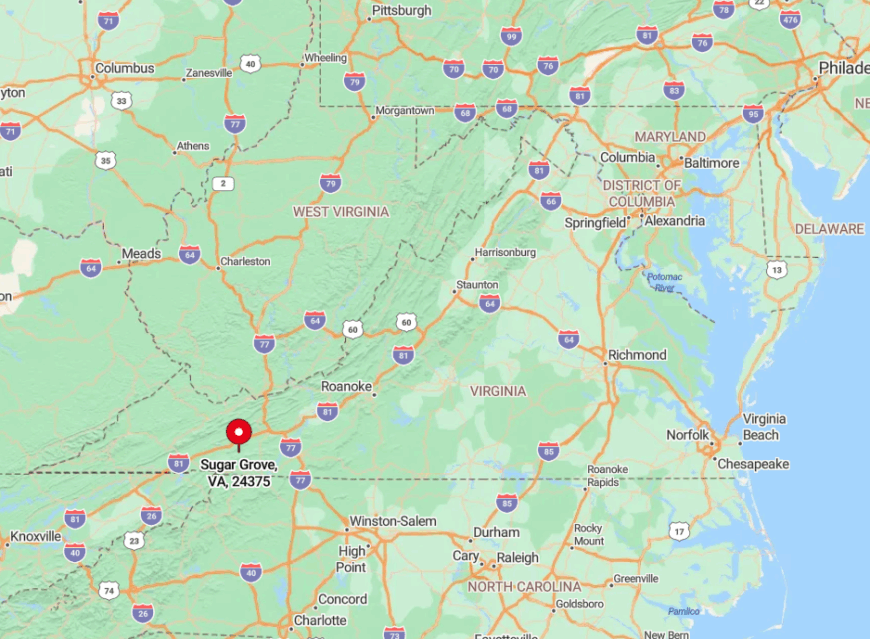
Sugar Grove lies along Virginia Route 16 between Marion and Troutdale. Iron Mountain hems the valley to the east while Mount Rogers Wilderness towers to the south, funneling weather and visitors alike into a narrow corridor.
Cell reception disappears before State Route 650, and winter rockslides occasionally close the road in either direction. Most travelers rely on Marion as the supply town then follow a thirty minute drive of hairpins to reach the quiet community.
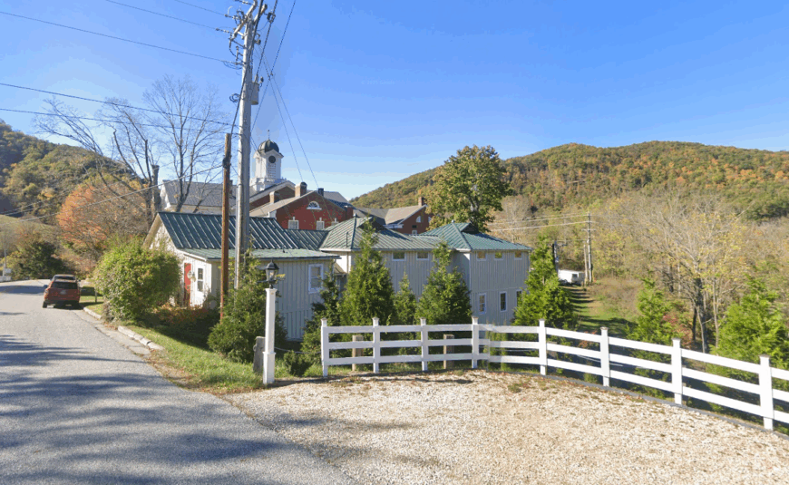
5. Troutdale, Grayson County
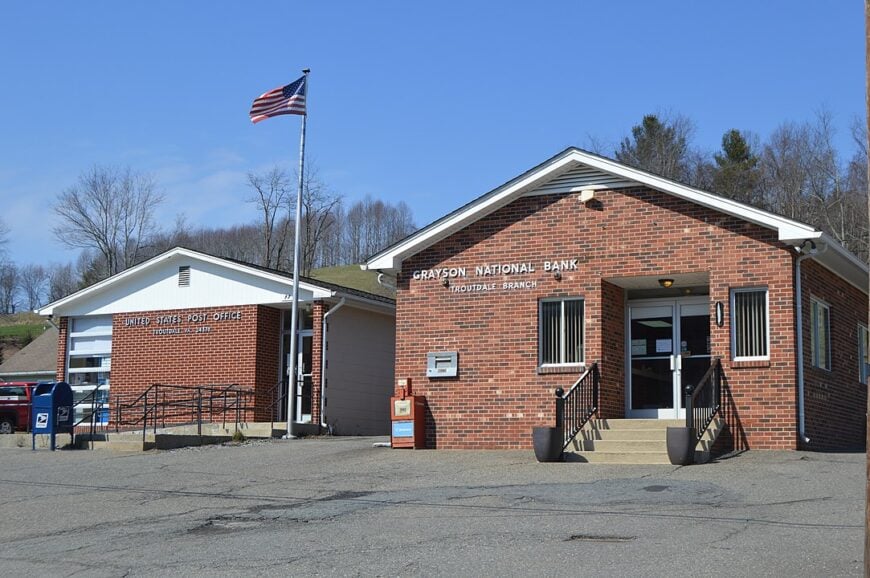
Troutdale lists about one hundred twenty permanent residents clustered around a stone firehouse and a single convenience store. The settlement serves as the eastern gateway to Mount Rogers National Recreation Area, placing wild ponies, rhododendron balds, and miles of trout streams within a short drive.
Beef cattle, small guest cabins, and forest service jobs account for much of the local income. Cattle pastures roll right up to fog shrouded hardwood ridges that remain largely roadless.
Night skies stay pitch black, revealing the Milky Way during most clear evenings. All this openness and a lack of through traffic establish Troutdale as one of Virginia’s quietest mountain outposts.
Where is Troutdale?
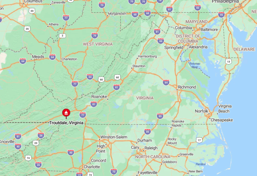
The village stands in eastern Grayson County where Routes 16 and 603 meet. Tall ridges to the north and west block direct passage, so even GPS recommends a circuitous approach.
Travelers exit Interstate 81 at Marion then negotiate twenty five miles of switchbacks before the valley finally widens. Winter ice routinely strands school buses on the climb, a local reminder of just how removed the community remains.
4. Warm Springs, Bath County
Warm Springs counts barely one hundred twenty residents scattered along U.S. 220 in Bath County. Travelers pause to admire the 18th-century courthouse, hike Hidden Valley Trail beside the Jackson River, or cast a line on the Cowpasture’s stocked waters. The pace is quiet, the streets uncluttered, and the mountains rise close enough to frame nearly every view.
Tourism linked to the historic bathhouses, small farms, and forestry anchor the economy. Properties often stretch across several acres, and artificial lighting is minimal, leaving the night skies unusually clear. The lack of glare lends the valley a depth of silence that feels rare in Virginia.
Owls provide most of the nightlife once the last car has passed through at dusk. Encircled by the Allegheny ridges and swaths of national forest, Warm Springs holds its ground against the push of heavy development, keeping the community firmly in step with its secluded past.
Where is Warm Springs?
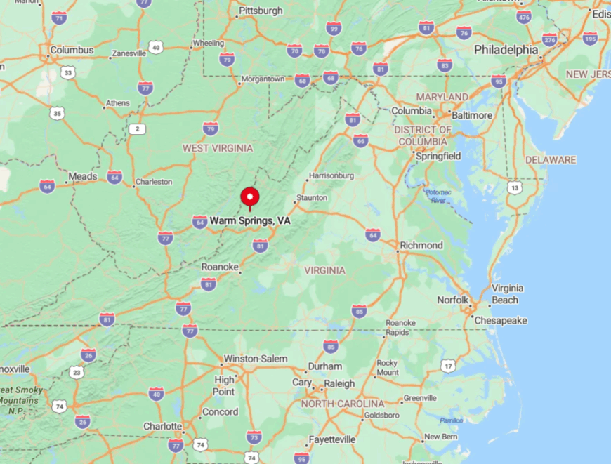
Warm Springs sits forty miles west of Lexington along US 220. Mountain walls cut radio signals, and snowfall can close the roadway south toward Covington.
With no commercial airport nearby, the easiest access is a scenic ninety minute drive from Interstate 64 in Clifton Forge. Those who make the trip discover a valley so quiet that the mineral springs can be heard trickling beside the road.
3. McCoy, Montgomery County
About seven hundred residents inhabit the scattered farmhouses of McCoy along a high bluff of the New River. Locals paddle to McCoy Falls, explore sandstone cliffs in Big Falls Park, and gather for bluegrass sessions at the Community Center each Saturday night.
Agriculture, a small limestone quarry, and remote professionals connected to nearby Virginia Tech underpin the economy. Weather-worn barns share pastures with grazing cattle and occasional bald eagles cruising the river.
Despite being just seventeen miles from Blacksburg, the absence of a direct four lane route limits traffic to a trickle. That geographic quirk, combined with patchy cell coverage, allows McCoy to feel removed from the wider New River Valley.
Where is McCoy?
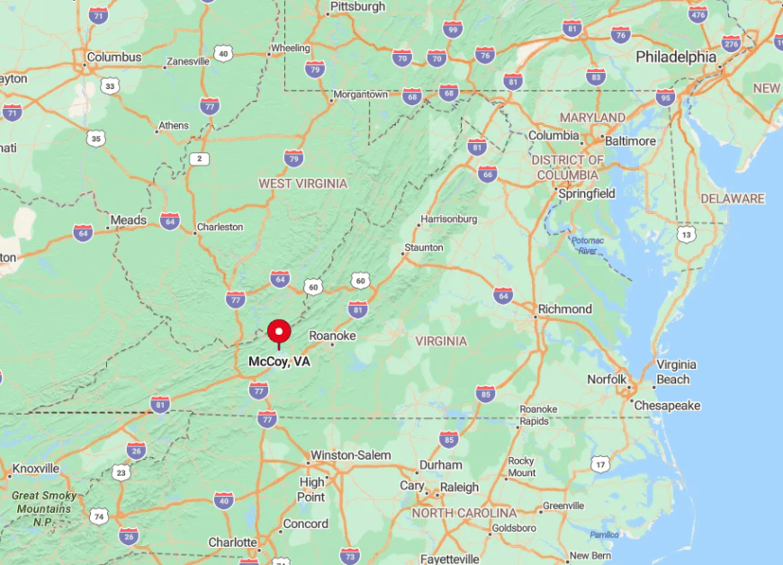
McCoy sits along the New River in western Montgomery County, reached from U.S. Route 460 west of Blacksburg. Drivers turn onto McCoy Road (State Route 723) or Big Falls Road, both of which wind through farmland before dropping into the river valley.
Brush Mountain blocks a direct route to town, forcing longer loops and keeping traffic light. The combination of narrow bridges, sharp turns, and patchy cell coverage makes the arrival feel more remote than the short distance on a map suggests.
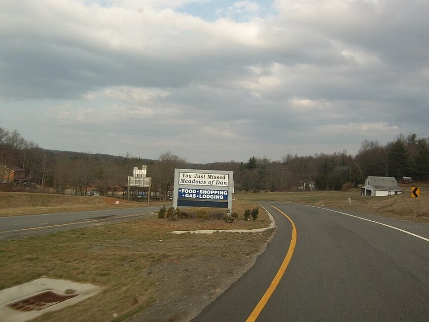
2. Meadows of Dan, Patrick County
Roughly three hundred people live in Meadows of Dan, a plateau village perched at 2,900 feet along the Blue Ridge. Stops include Mabry Mill, berry picking at Levering Orchard, and sunrise walks through Buffalo Mountain Natural Area Preserve.
Handcrafted furniture, seasonal produce stands, and Parkway tourism yield most local income. Split rail fences frame upland hayfields that roll toward distant piedmont haze.
Tourist numbers dip sharply once the Blue Ridge Parkway’s main leaf season ends. With no chain hotels and limited cell service, Meadows of Dan reverts to a tranquil farm community for much of the year.
Where is Meadows of Dan?
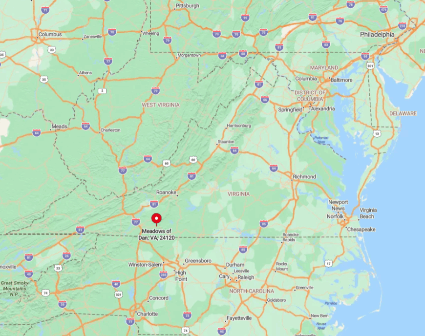
The village straddles Patrick County’s boundary with Floyd County at Parkway milepost 178. Elevated terrain and frequent fog discourage hurried driving, naturally reducing visitor counts.
Access comes via US 58 from Stuart or Hillsville, yet both approaches involve steep grades and climbing curves. Snowfall can shutter the Parkway entirely, isolating Meadows of Dan from early winter to spring thaw.
1. Catawba, Roanoke County
Catawba hosts about seven hundred fifty residents on broad valley farms beneath the sandstone spine of North Mountain. Hikers test themselves on Dragon’s Tooth, anglers stalk rainbow trout in Catawba Creek, and hungry travelers queue outside the weekend-only Homeplace Restaurant.
Horse breeding, row crop agriculture, and a Virginia Tech research center sustain the local economy. Homes stand well apart, divided by pastures and split by long gravel driveways.
National forest boundaries hem in the valley, and the only nearby store closes before sunset. These factors together allow Catawba to remain surprisingly quiet despite its proximity to Roanoke.
Where is Catawba?
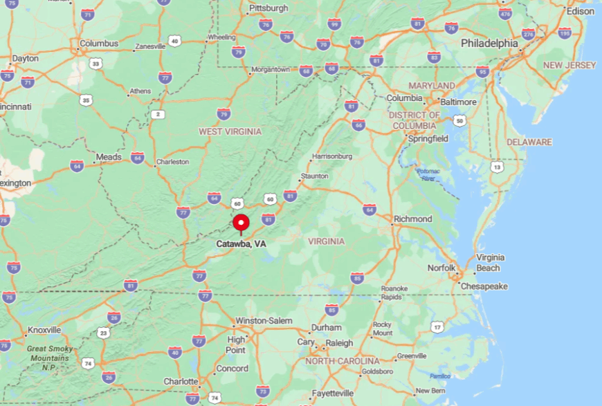
The community lies fifteen miles northwest of Roanoke along Virginia Route 311. Brush Mountain to the south and Sinking Creek Mountain to the north channel all traffic through a narrow notch at Craig Creek.
Public transport ends in Salem, and winter ice on Catawba Mountain often forces temporary closures. Drivers who brave the grades discover rolling meadows framed by peaks and a level of calm rare so close to a metro area.


