Northwestern New Jersey can feel worlds apart from the bustling suburbs that ring New York City and Philadelphia. Tucked among the Kittatinny Mountains, Jenny Jump ridges, and leafy valleys are tiny hamlets where star-filled skies, gravel lanes, and farm calls still set the daily rhythm.
In order to come up with the very specific design ideas, we create most designs with the assistance of state-of-the-art AI interior design software. Also, assume links that take you off the site are affiliate links such as links to Amazon. this means we may earn a commission if you buy something.
Our roundup visits 25 of these spots, counting down from the best-known hideaways to the least-traveled corners, all within roughly an hour and a half of Manhattan yet separated by forest preserves and winding backroads.
Each village offers its own blend of outdoor adventures, historic character, and near-total quiet—qualities that make them magnets for weekend explorers and folks hunting for a slower pace year-round.
Along the way we highlight little-known trails, century-old craft traditions, and under-the-radar farm markets that reward anyone willing to follow the less obvious route. Pack a paper map, because cell service fades fast in these hills.
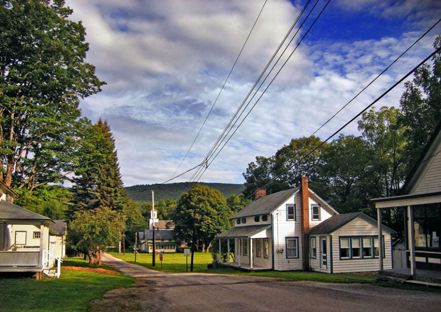
25. Layton – Crossroads Hamlet in the Kittatinny Foothills
Layton is a pocket-sized village where the Flat Brook curves under the shadow of the Kittatinny Ridge. A few dozen homes, a weathered general store, and the clapboard grange hall are its main features, yet the place feels timeless.
The Peters Valley Craft School sits just up the road, but the hamlet itself remains quiet except for birdsong and brook water. Visitors often pause to photograph the 19th-century Dutch Reformed Church or to launch a canoe on the nearby Delaware River.
Farming and heritage tourism provide most of the activity, though daily life moves slowly. Its remoteness from highways preserves a hush that modern suburbs can’t touch. Layton is the kind of spot where the stillness feels deliberate, not accidental.
Where is Layton?
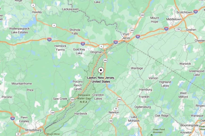
Layton sits in Sandyston Township, Sussex County, just east of the Delaware River and High Point State Park. It lies about 12 miles northwest of Newton but is cut off by winding county roads that trace forested ridges.
The main approach is County Route 560, a narrow route with few signs of commerce. Reaching the hamlet feels like stepping into a preserved pocket of the 19th century.
24. Delaware (Delaware Station) – Ruins Beside the River
Delaware is more of a name on a map than a town these days, yet its abandoned rail station and historic church draw curious wanderers. Set on the Delaware River’s east bank, the hamlet once shipped grain and slate; today it whispers with crickets and the creak of timbers.
The decaying station, stone foundations, and the tiny cemetery offer a haunting sense of history. Anglers slip into the river here, while hikers pick up trails into Worthington State Forest.
Farming remains nearby, but the hamlet itself is largely a memory. Its blend of beauty and abandonment makes it one of New Jersey’s most secluded places.
Where is Delaware?
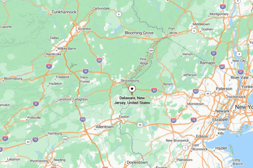
Delaware rests in Knowlton Township, Warren County, near the I-80 bridge to Pennsylvania but hidden from view. Travelers exit the interstate at Columbia and follow River Road south until old buildings appear along the banks.
The lack of services and the proximity of the water make it feel cut off from modern life. Standing among the ruins, the world feels hushed and far away.
23. Montague Hamlet – Edge of the State
Montague’s historic hamlet straddles the border of New Jersey, Pennsylvania, and New York, making it feel like a crossroads at the end of the line. Old farmhouses line River Road, while antique shops and seasonal produce stands nod to its agrarian past.
The Delaware River runs wide here, offering canoe launches and bald-eagle sightings. Summer travelers stop for ice cream or to drive to High Point, but the hamlet itself sees little bustle.
Its seclusion comes from geography: mountains rise behind, rivers flank the sides, and highways detour elsewhere. Residents keep to themselves, tied to farms, cabins, and river recreation. Montague’s quiet edges make it feel like a forgotten threshold.
Where is Montague?
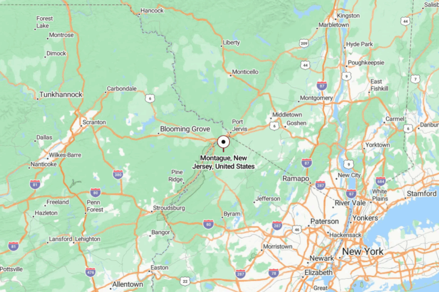
Montague Hamlet sits in Sussex County’s far northwest corner, bordered by two states. It lies about 12 miles north of Branchville but feels worlds away, shielded by the Delaware River and High Point State Park.
Access comes via Route 206, then narrow River Road winding along the water. It’s the sort of place where state lines blur, and time slows down.
22. Allamuchy Hamlet – Stone Houses Beside the Park
Allamuchy’s original hamlet, distinct from the surrounding township, clusters around stone houses, a post office, and the old train station. Locals fish at Allamuchy Pond or hike into Allamuchy State Park, yet the hamlet itself remains hushed.
The village green, flanked by colonial-era homes, offers a snapshot of New Jersey’s early farming life. With Route 80 a few miles away, it’s surprisingly accessible yet invisible to most travelers.
Small inns and equestrian barns form the main businesses, while many residents commute to larger towns. The lack of retail strip development preserves its historical air. Allamuchy feels like an entry point to another century.
Where is Allamuchy?
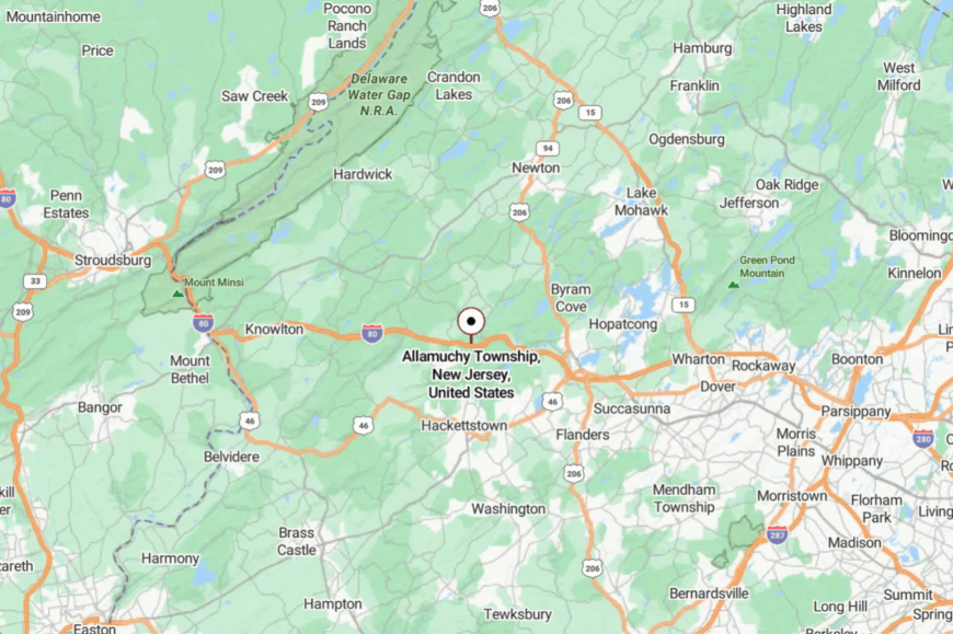
The hamlet lies in Warren County, just east of Hackettstown and west of Allamuchy State Park. Drivers usually leave Route 80 at Exit 19 and follow County Route 517 into farmland.
The hills block noise from the interstate, and tall oaks conceal the clustered homes. By the time you arrive, the modern world has already slipped from view.
21. Blairstown Historic Core – Millpond Stillness
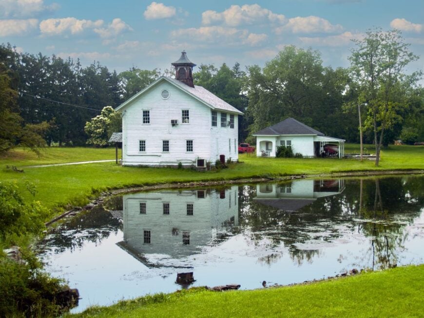
Blairstown’s historic core centers on a millpond lined with 19th-century storefronts and a stone mill turned café. Though the wider township is busier, the hamlet-sized center feels hushed, especially after shops close for the day.
Kayakers paddle the pond, and hikers set out for the Appalachian Trail just beyond town. The restored Roy’s Hall hosts small concerts, but otherwise evenings echo with peepers and church bells. Farming and small commerce shape the local economy.
What sets it apart is the sudden silence once you leave Route 94 and enter the narrow main street. It’s a pocket of seclusion within a larger landscape.
Where is Blairstown?
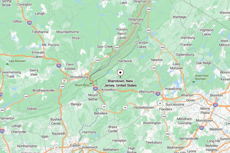
The historic hamlet lies in northwestern Warren County, about 10 miles from the Delaware Water Gap. It sits just off Route 94, with parking clustered near the millpond.
Commuter routes bypass the old core, leaving it peaceful. The water, trees, and stone facades give the place a timeless air.
20. Hardwick Hamlet – Quiet Crossroads
Hardwick Hamlet is a blink-and-you’ll-miss-it settlement of barns, stone houses, and one-room churches. With no stores or restaurants, the village remains almost entirely residential, framed by cornfields and wooded ridges.
Hikers use it as a gateway to the Delaware Water Gap’s trails, but the roads empty quickly after sunrise. Locals maintain generational farms, some dating back to the 18th century. A handful of home businesses—maple syrup, handcrafts, seasonal produce—round out the economy.
The lack of through roads or signage adds to its invisibility. Hardwick is the kind of place where the loudest sound might be a screen door closing.
Where is Hardwick?
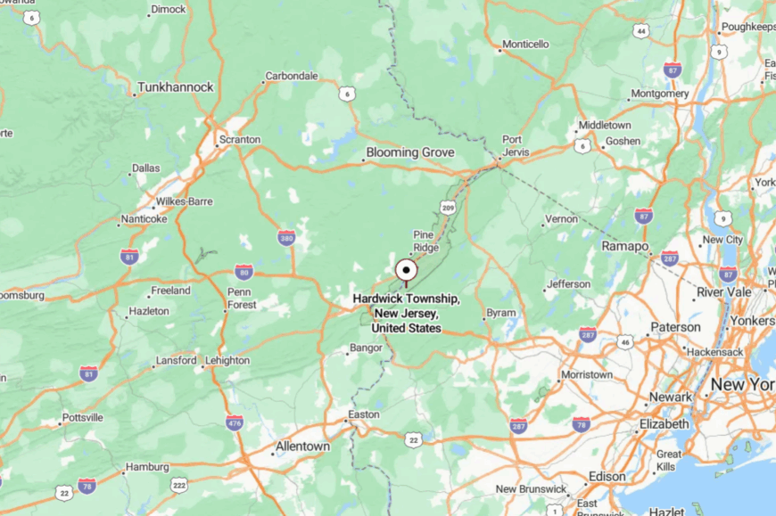
The hamlet sits in central Warren County, tucked between Blairstown and Stillwater. County Route 521 passes nearby, but the village itself lies a half mile off the main drag.
Visitors often find it by accident while following backroads to the Delaware River. The surrounding fields and forests keep it cocooned in quiet.
19. Anderson – By the Pequest’s Springs
🔥 Would you like to save this?
Anderson is a small farming hamlet that clings to the Pequest River, best known for its nearby trout hatchery. The village itself is little more than a crossroads of farmhouses, barns, and a church.
Locals tend dairy herds, cornfields, and roadside stands, but commerce is minimal. Anglers pass through for fishing, and birders watch herons and osprey in the wetlands.
With Route 46 nearby but unseen, the hamlet remains hidden from traffic. Its air smells of hay, watercress, and woodsmoke. Anderson’s charm lies in how little it has changed.
Where is Anderson?
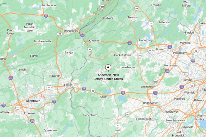
Anderson rests in Mansfield Township, Warren County, about six miles southeast of Hackettstown. It’s accessible via County Route 517, though small bridges and bends slow travel.
The village sits in low fields by the river, shielded from road noise by ridges. Arriving here feels like turning a page back in the county’s history.
18. Shiloh – Ridge-Top Refuge
Shiloh is one of those map-dot hamlets that might escape notice, save for its old church and scattering of farmsteads. Perched on a ridge, it overlooks valleys quilted with corn and hay fields.
Life here is defined by barns, tractors, and quiet evenings where lights glow faintly across the hills. A historic cemetery recalls Revolutionary-era families, while the church occasionally hosts potlucks.
Few businesses exist; farming dominates. Its seclusion stems from elevation and distance—no main highway passes nearby, and steep roads discourage shortcuts. Shiloh embodies rural calm.
Where is Shiloh?
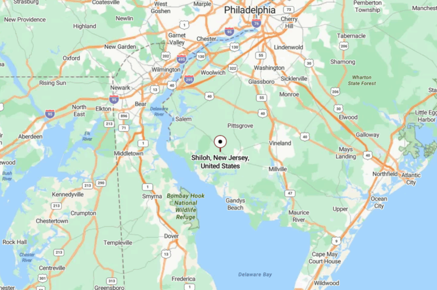
Shiloh lies in Warren County, a few miles north of Belvidere and west of Route 519. Approaches involve winding hill roads that crest before dropping into the hamlet.
The absence of signage keeps traffic minimal. The ridge setting provides both vistas and isolation.
17. Ackerson – Lakeside Cluster
Ackerson is a hidden lakeside hamlet in Andover Township where cottages, barns, and century-old homes cluster near quiet waters. Once an ironworking site, the area now draws anglers and birdwatchers who savor the unspoiled shoreline.
Families gather at tiny beaches, while hikers connect to forest trails leading into Allamuchy Mountain. The economy is rooted in small farms and weekend rentals, but year-round residents prize the calm.
With no shops or main roads, evenings are lit only by porch lamps. Ackerson feels tucked away, sealed by trees and history alike.
Where is Ackerson?
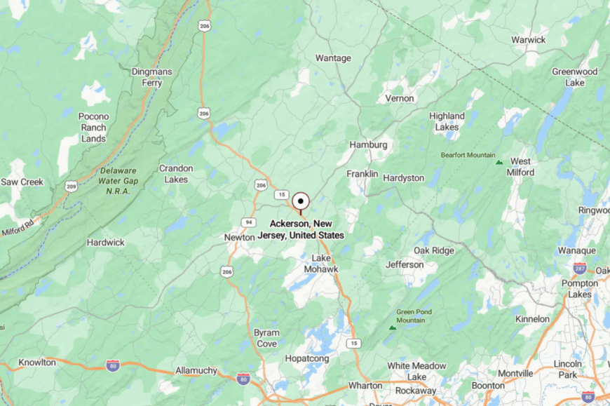
The hamlet lies in Sussex County, just south of Andover Borough and east of Route 206. A short drive down Ackerson Road leads to its cottages and lake edges.
The lack of through traffic keeps it still. The hush is broken only by the call of loons and the lap of water.
16. Mohican Hamlet – Along the Appalachian Trail
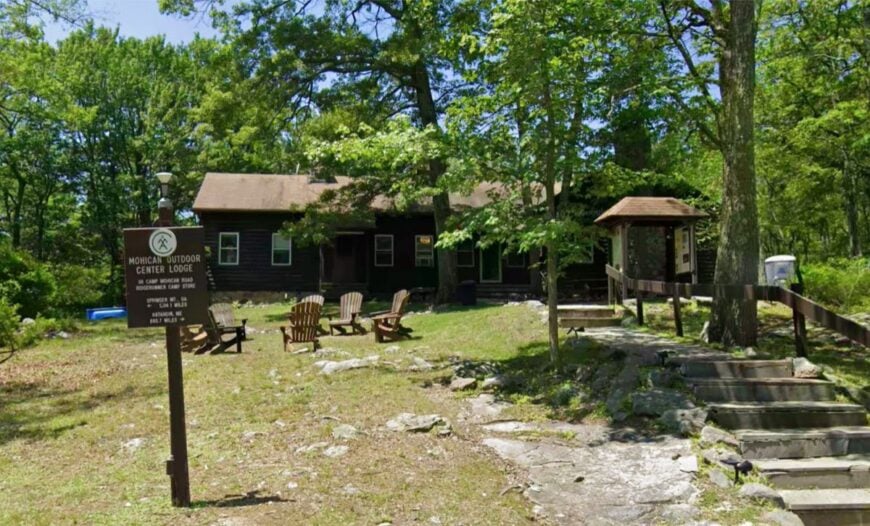
Mohican Hamlet, sometimes known by the Mohican Outdoor Center nearby, feels less like a village and more like a forest outpost. Scattered cabins, a lodge, and a few homesteads tuck into the Delaware Water Gap woods.
Hikers on the Appalachian Trail rest here, while locals enjoy canoeing Catfish Pond or stargazing under pitch-dark skies. Tourism and seasonal guiding form the core economy, but otherwise life moves at camp speed.
Roads in are winding and steep, discouraging casual visits. Its seclusion comes from being surrounded by preserved wilderness. Mohican is a reminder of how wild New Jersey’s northwest still is.
Where is Mohican?
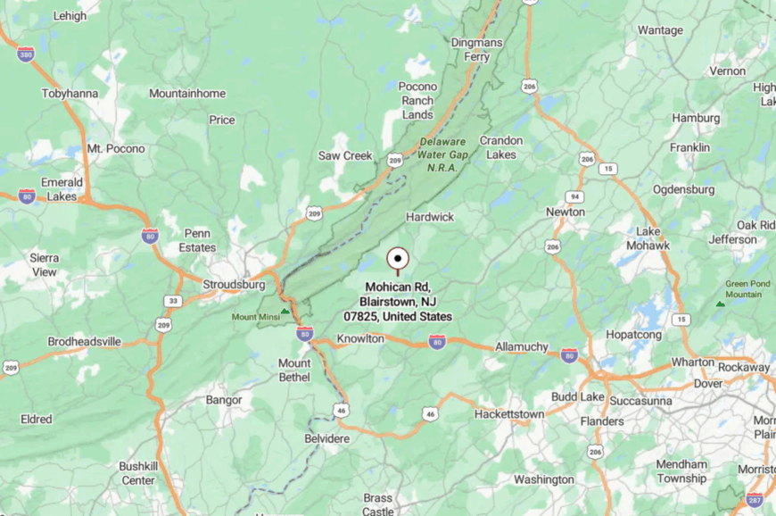
The hamlet sits in Blairstown Township, Warren County, within Worthington State Forest. Access is by Mohican Road, a winding route branching off Route 94.
The last miles narrow into a forest track, often impassable in winter. That isolation ensures the hamlet remains quiet year-round.
15. Liberty Corner – Forgotten Farm Crossroads
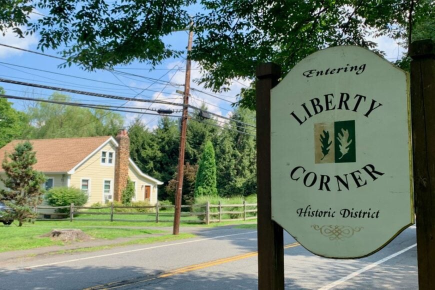
Liberty Corner is a faint hamlet marked by a handful of homes, barns, and a disused schoolhouse. Once a stagecoach stop, it now feels like farmland frozen in time. Cornfields stretch in every direction, and few cars pass by on a given day.
Residents tend cattle or work remotely, with little need for commerce. Hikers explore nearby Pequest WMA, and history buffs photograph old barns and stone fences. Its seclusion is absolute: no gas, no shops, not even a signpost announcing the place.
Liberty Corner is the kind of spot where you notice the hum of insects more than the sound of engines.
Where is Liberty Corner?
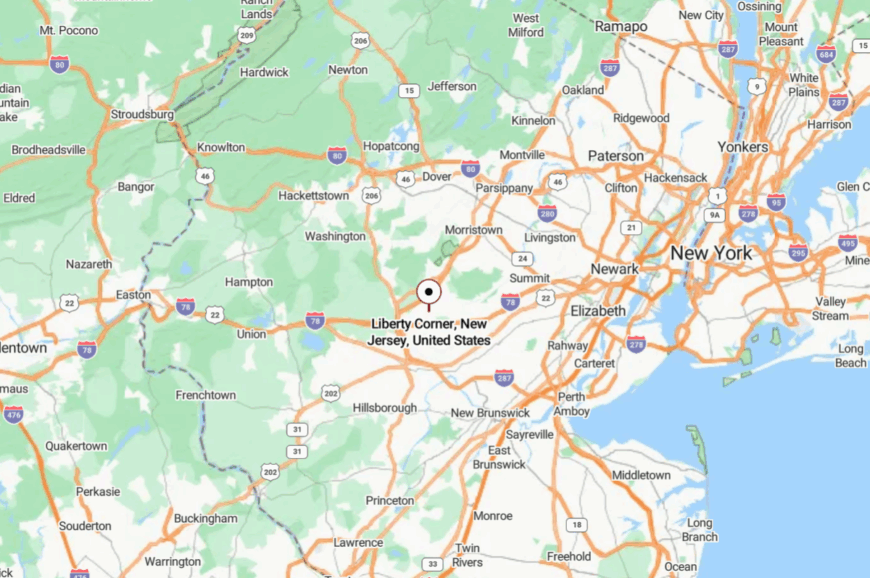
The hamlet is located in Warren County, about five miles northeast of Belvidere. Access comes via County Route 623 and a web of local farm roads.
Rolling hills block sightlines, so the hamlet appears suddenly at a crossroads. The landscape and silence cloak it in solitude.
14. Pahaquarry – Ghost Hamlet in the Delaware Gap
Pahaquarry is technically a ghost town now, but its church ruins and cemetery preserve the spirit of an isolated hamlet. The village once supported mining and farming families, but after the area was acquired for federal parkland, homes disappeared.
Today, mossy stone foundations, fieldstone fences, and the old church shell remain. Hikers follow Old Mine Road past its relics, while naturalists spot bears and wild turkeys nearby.
There is no economy, only memory. Yet Pahaquarry’s emptiness gives it a special weight: silence thick enough to feel. It’s as secluded as New Jersey gets.
Where is Pahaquarry?
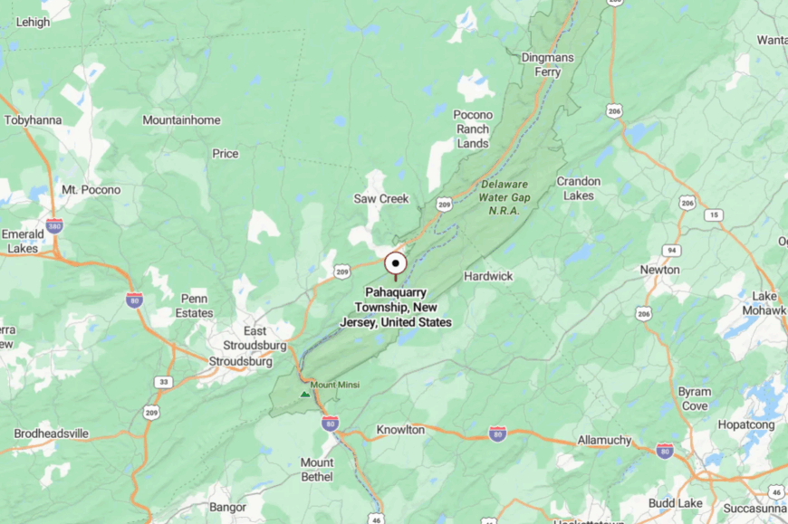
Pahaquarry lies within Walpack Township, Sussex County, inside the Delaware Water Gap National Recreation Area. It’s accessible by Old Mine Road, a narrow, winding historic route.
The nearest highway is Route 80, nearly 20 miles south. Standing there, you sense the distance not just in miles but in time.
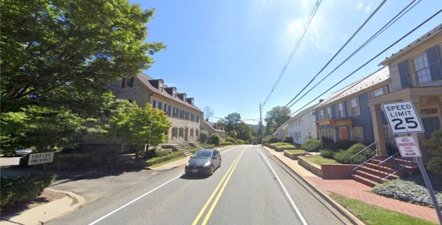
13. Hope Village – Moravian Roots in the Foothills
🔥 Would you like to save this?
Hope Village feels like a time capsule, its stone Moravian buildings from the 1700s still framing the green. About 200 residents live in restored homes where lilacs edge picket fences, and most traffic is from those heading to the small café or antiques shop.
The grist mill, church, and a handful of shops remind visitors of the town’s colonial roots, while the lack of modern strip malls preserves the old-world character. Surrounded by hills and farmland, the village stays quiet once you leave Route 519.
Local festivals bring a gentle bustle, but most days you hear more birdsong than cars. Farming, small commerce, and heritage tourism support the economy. Hope’s seclusion feels intentional—like a community that chose to keep its past alive.
Where is Hope Village?
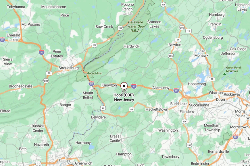
The hamlet sits in Warren County, about five miles south of Blairstown and close to the Jenny Jump State Forest ridgeline. It’s just off Route 519, but dense trees and stone walls buffer it from passing traffic.
Access is through winding county roads that narrow as they near the historic district. Arriving feels less like entering a modern town and more like stepping into a preserved storybook corner of New Jersey.
12. Mount Olive Village – Bygone Center of the Township
Mount Olive Village is a small historic settlement distinct from the sprawl of nearby Budd Lake. Centered on a historic church, cemetery, and a few farmhouses, it offers a glimpse of the township’s 18th-century roots.
Farming remains on the outskirts, while most daily life has shifted to other parts of the township, leaving the core hushed. Visitors admire old stone walls, timber barns, and the village green. Seasonal events bring neighbors together, but otherwise, life here is slow and spare.
Its seclusion comes from being bypassed by highways, tucked in the hills just far enough from the main road. Mount Olive Village is the quiet heart behind a busy township.
Where is Mount Olive Village?
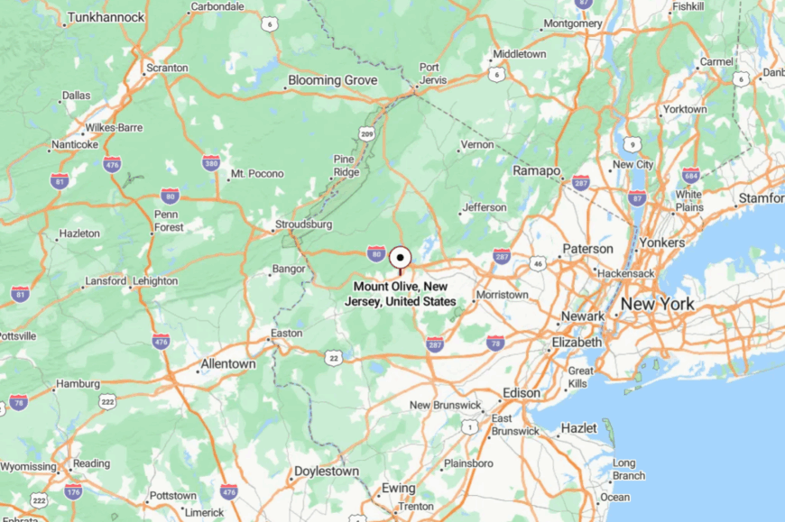
The hamlet lies in Morris County, a mile east of Budd Lake but invisible from Route 46. Access comes by Flanders Road and winding lanes that pass farm fields and historic houses.
The absence of retail or gas stations adds to the sense of stillness. Though near modern development, the village feels hidden in plain sight.
11. Stillwater Village – Lakeside Heritage Hamlet
Stillwater Village feels like a postcard from the 18th century, with its stone church, weathered barns, and cottages tucked around Stillwater Lake. Founded by Dutch settlers, it retains a deep agricultural character, where cornfields meet mirror-still water and winding dirt lanes.
The old grist mill and general store mark the historic center, while nearby farms sell maple syrup, honey, and pumpkins. Kayakers and bird-watchers gather at the lake, but otherwise daily life remains hushed. Evenings here are punctuated only by frogsong and the creak of porches.
Stillwater’s seclusion stems from geography—rolling ridges and wetlands hem it in on all sides. The sense is less of a destination and more of a hidden fold in the hills, unchanged by time.
Where is Stillwater?
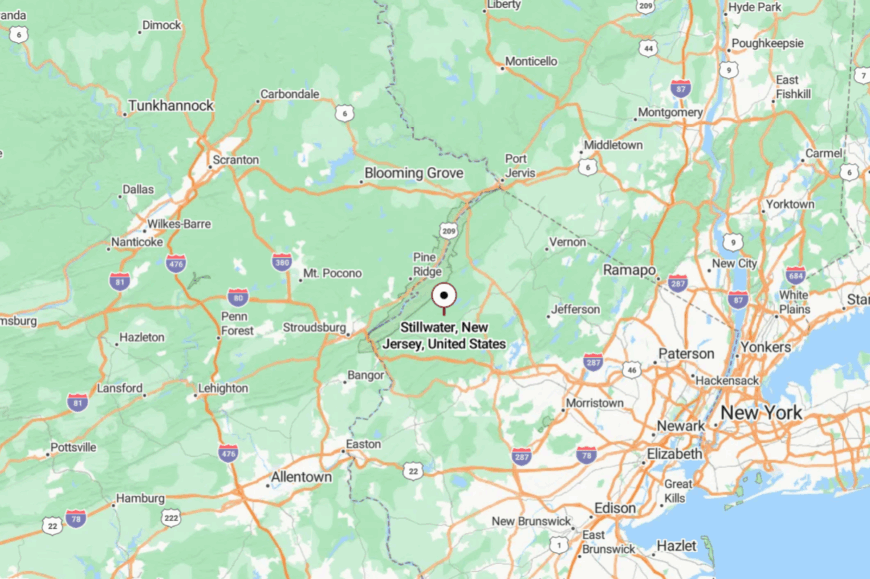
Stillwater lies in Sussex County, about eight miles west of Newton and a short drive north of Swartswood State Park. The main approach is via County Route 521, which narrows into winding farm lanes before reaching the village green.
With no major highways nearby and little signage, arriving feels like stumbling upon a preserved corner of old New Jersey.
10. Walpack Center, Walpack Township
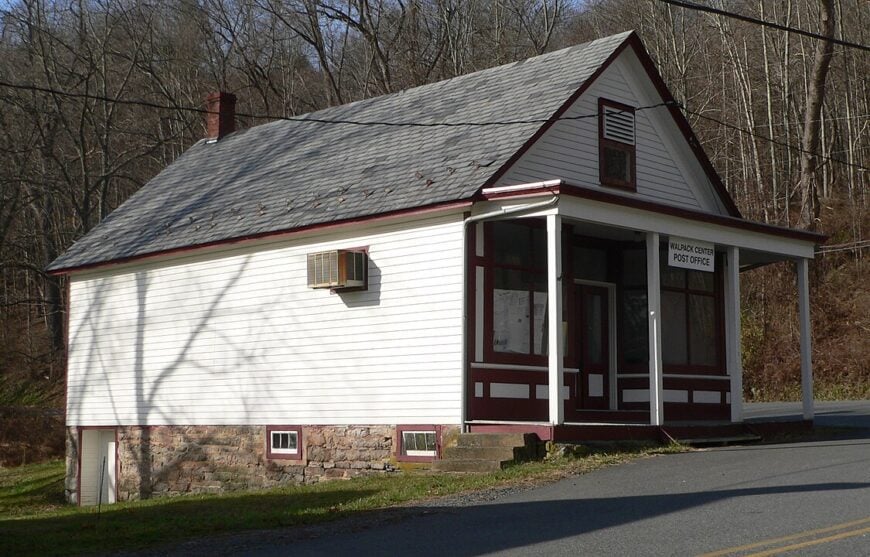
Fewer than twenty people keep year-round addresses in Walpack Center, a hamlet that looks much as it did in the 1860s. Visitors stroll its one-block “main street” to photograph the weather-beaten post office, explore the tiny historical society museum, or hike nearby Buttermilk Falls, New Jersey’s tallest waterfall.
Small-scale ranching and seasonal tourism supply the scant commercial activity, while many residents work remotely or commute long distances.
Encircled by 70,000 acres of the Delaware Water Gap National Recreation Area, the community is cut off from sprawl by federal land, steep ridges, and a river that floods local roads after heavy rain.
Mail still arrives by rural route, and most homes sit on multi-acre lots framed by split-rail fences. Nights are silent enough to hear barred owls calling from the Kittatinny foothills.
Where is Walpack Center?
The hamlet lies in the southwest corner of Sussex County, roughly 12 miles northwest of Branchville. Two narrow approaches—Walpack Flatbrook Road and Main Street off Old Mine Road—wind through dense hardwoods and over one-lane bridges, discouraging casual traffic.
The closest state highway is Route 206, nearly half an hour away, underscoring why the spot feels lost in time. Many GPS units mis-pin the address, so travelers often rely on park wayfinding signs or paper directions.
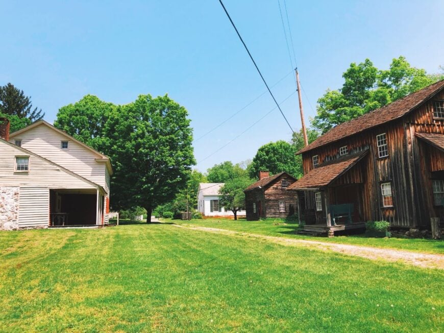
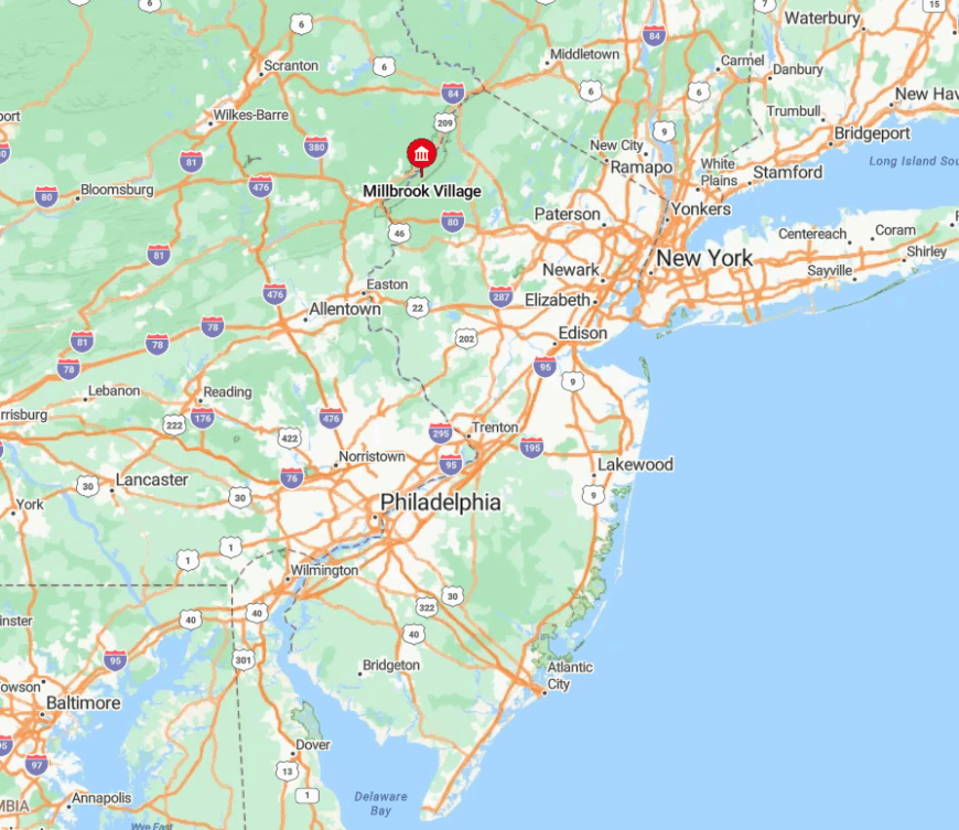
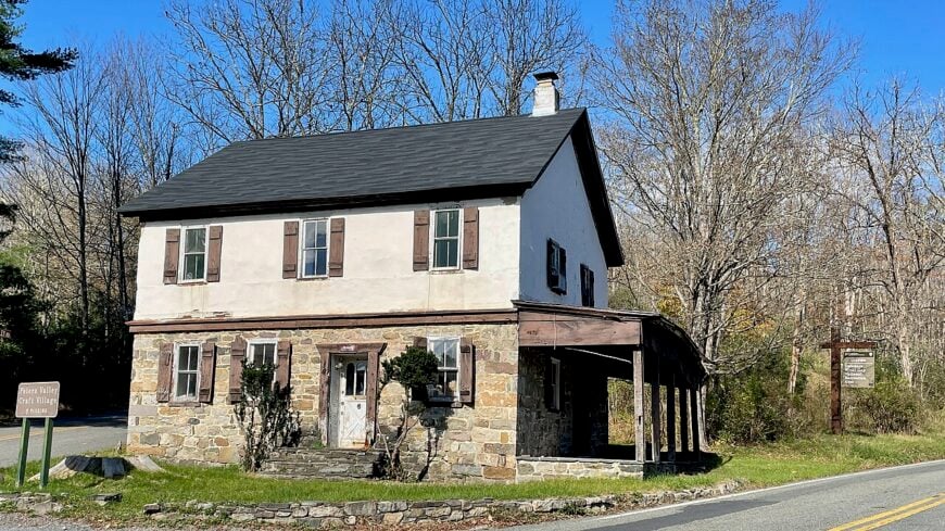
9. Millbrook Village, Hardwick Township

Millbrook Village has no permanent census count, but the National Park Service lists a half-dozen caretakers who maintain its mid-19th-century structures. Day-trippers come for blacksmith demonstrations, berry picking along the Van Campen Inn trail, and snow-blanketed cross-country ski loops in winter.
Heritage tourism employs the interpreters, while nearby farms supply seasonal produce to pop-up markets on event weekends. Surrounded by more than 50,000 acres of federal parkland and hemlock ravines, the settlement sits fifteen miles from the nearest suburb, leaving it free of traffic noise and light pollution.
Buildings are spaced widely apart, giving wildlife easy passage through orchard remnants and old mill races. After dusk, only kerosene lanterns and the rush of Millbrook Creek break the darkness.
Where is Millbrook Village?
🔥 Would you like to save this?
Situated in Warren County along Old Mine Road, Millbrook rests four miles south of the Delaware River crossing at Dingmans Ferry. The route in snakes across one-lane wooden bridges, forcing motorists to slow to bicycle speed.
Cell reception evaporates after the first hairpin, adding to the sense of remoteness. Most visitors park in a gravel lot and walk the last quarter mile under towering white pines.
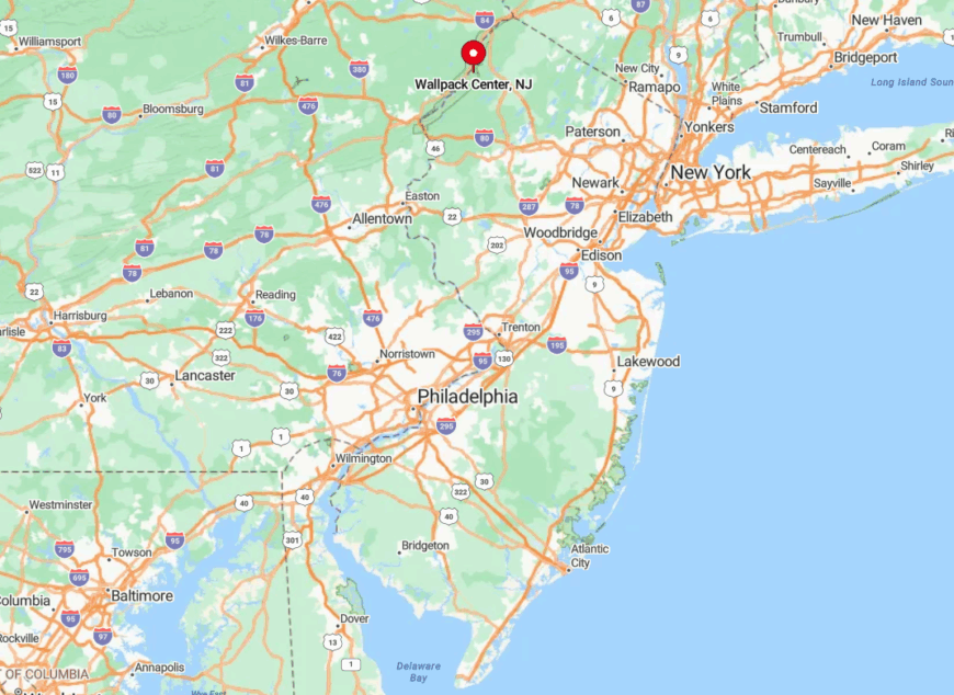
8. Peters Valley (Bevans), Sandyston Township
Peters Valley hosts about fifty full-time residents, many affiliated with the nationally known Peters Valley School of Craft. Pottery firings, glass-blowing demos, and an annual fine-craft fair draw makers from around the country, while anglers head for the Flat Brook’s wild rainbow trout runs.
Arts education and heritage tourism form the economic backbone; a handful of family farms and B&Bs round out local income. Homes lie an acre or more apart, screened by ridgelines and red-oak stands that hush road noise from Route 560 four miles away.
The absence of streetlights preserves pitch-black skies, perfect for summertime meteor showers. Even the local general store doubles as an art gallery, underscoring the community’s creative leanings.
Where is Peters Valley?
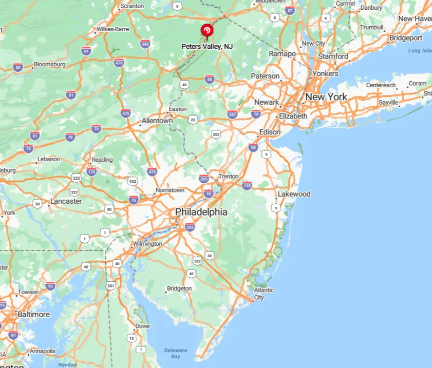
The village sits in Sussex County, two miles east of the Delaware River and five miles north of Layton. Drivers leave County Route 640 and drop into the valley on Bevans Road, a ribbon of pavement that narrows to a single lane in places.
With no through streets, every arrival is intentional, keeping sight-seers to a trickle. Once there, most people park at the craft campus and explore on foot or bike.
7. Flatbrookville, Walpack Township
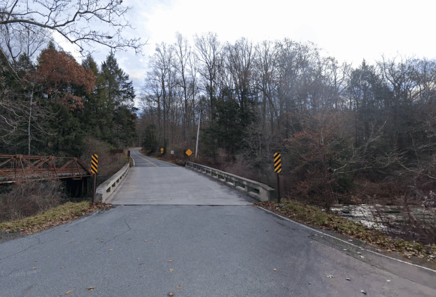
Only about thirty residents claim year-round addresses in Flatbrookville, where clapboard homes peek over stone walls toward the Flat Brook. Canoe launches, bald-eagle nests, and quiet stretches of the Appalachian Trail lure naturalists, while photographers prize the unobstructed mountain vistas.
Subsistence farming, seasonal guiding, and park maintenance provide modest employment options. The lane dead-ends at the brook, eliminating pass-through traffic and reinforcing the village’s hush.
With no commercial strip and the nearest gas pump eight miles away, life slows to the pace of the river. Deer, rather than neighbors, are the most frequent front-yard visitors.
Where is Flatbrookville?
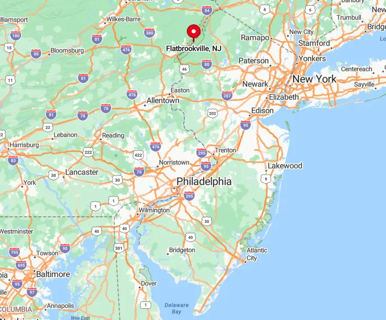
Found in the northwestern pocket of Sussex County, Flatbrookville hides three miles down Flatbrook-Stillwater Road from its junction with Route 615. Sheer ridges block cell towers, and the brook’s floodplain often closes the main access after heavy storms.
Reaching the hamlet usually involves a detour through gravel forest tracks maintained by the National Park Service. The final approach crosses a timber trestle bridge that squeaks under even lightweight cars.
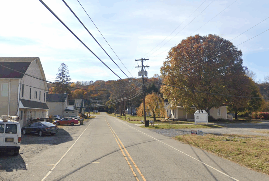
6. Johnsonburg, Frelinghuysen Township
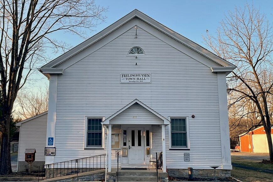
Roughly 500 people live in Johnsonburg, a crossroads village known for stone churches and broad dairy pastures. Visitors pop into the 1850s gristmill-turned-café, fish the quiet corners of Furnace Brook, or pedal gravel bikes along the Paulinskill Valley Trail.
Agriculture remains the main industry, complemented by a growing number of remote workers drawn to the scenery. Sheltered by Jenny Jump Mountain to the south and rolling foothills on every side, the village sits far from interstate noise and shopping centers.
Evenings feature dim porch lights, crickets, and little else. Locals proudly recount that the town once hosted New Jersey’s largest butter churn, a relic now displayed at the township garage.
Where is Johnsonburg?
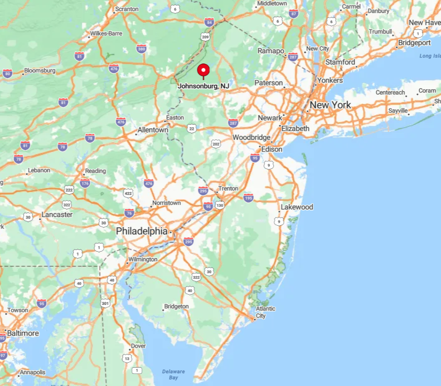
The hamlet lies in central Warren County, about five miles north of Hope and nine miles from Route 80’s nearest exit. County Route 661 winds through farm country before dropping into the village green, where traffic seldom tops 25 mph.
Commuter buses do not serve the area; most people arrive by car or bicycle. The surrounding ridgelines block radio stations, so travelers often bring playlists for the drive.
5. Hainesburg, Knowlton Township
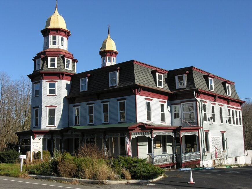
Hainesburg lists approximately 150 residents living in gingerbread-trimmed Victorians and weathered farmhouses. Bird-watchers frequent the Marble Hill Natural Area, while kayakers portage into the Paulins Kill for mile-long flat-water stretches.
Small family farms and equestrian boarding barns dominate the local economy, with a handful of artisans selling preserves and woodcraft from roadside stands. Buffered from Interstate 80 by several miles of cornfields and the Kittatinny Ridge, the village hears more whip-poor-wills than truck traffic.
The absence of streetlights keeps nights ink-black, and residents rely on well water and septic systems rather than municipal utilities. A century-old steel truss bridge over the kill acts as the town’s unofficial welcome sign.
Where is Hainesburg?
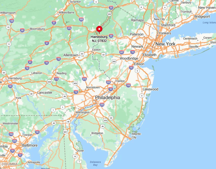
Located in Warren County just west of Route 94, Hainesburg sits three miles northeast of the Delaware River bridge at Columbia. Narrow Walnut Valley Road climbs a wooded gap before dropping into the hamlet, a route often closed by winter ice.
No train or bus links exist, so the simplest approach is via car from Blairstown or Columbia. GPS directions sometimes miss the final turn, but locals advise looking for the red barn with a painted hex sign.
4. Marksboro, Frelinghuysen Township
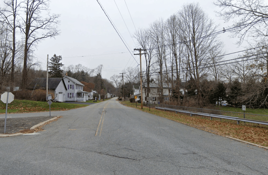
Marksboro is home to about one hundred residents and a postcard cluster of Federal-era brick houses circling a millpond. Travelers picnic beside the 1820 iron truss bridge, photograph the water-wheel remains, or hike the hidden Jenny Jump footpath that starts behind the old feed store.
A small nursery greenhouse and seasonal farm stands form the commercial core, while many locals telecommute or farm corn and hay. With roughly 70 percent of its surrounding land undeveloped, the enclave enjoys sable-dark skies and silence broken only by spring peepers.
Nighttime ATV use is banned, preserving the calm. The historic Methodist church bell still rings every Sunday morning, echoing across open fields.
Where is Marksboro?
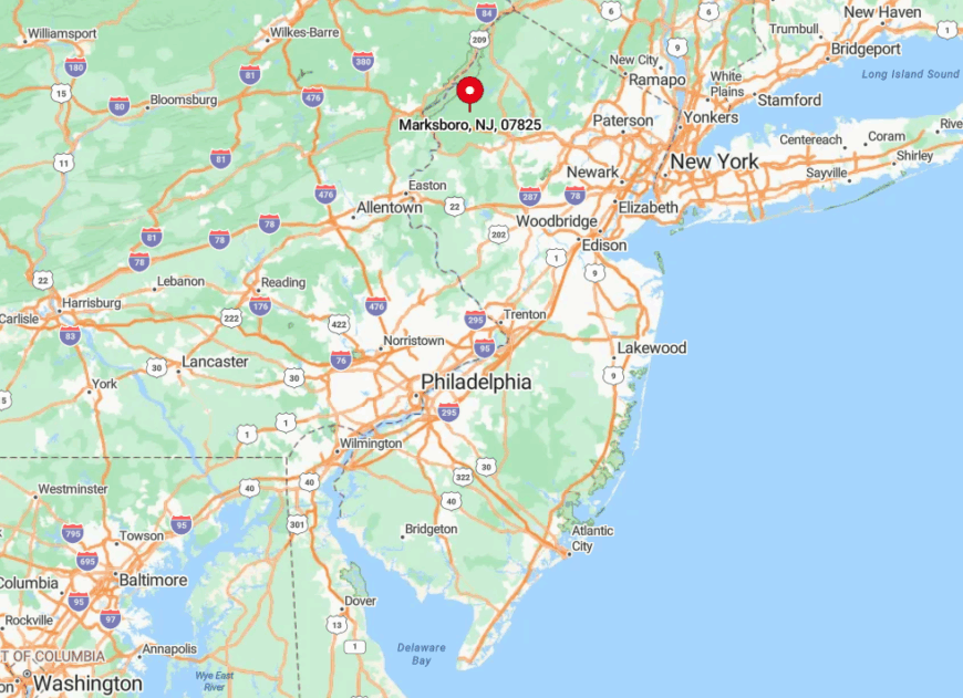
Set in northern Warren County, Marksboro sits along County Route 661, five miles northeast of Hope and seven miles from U.S. Route 206. The approach crosses rolling farmland that blocks views of distant towns, creating an instant sense of seclusion.
Without gas stations or stores in-town, visitors top up supplies before leaving the highway. The Paulinskill Valley Trail parallels the hamlet, but the nearest trailhead is a two-mile walk, adding to the out-of-the-way feel.
3. Greendell, Green Township
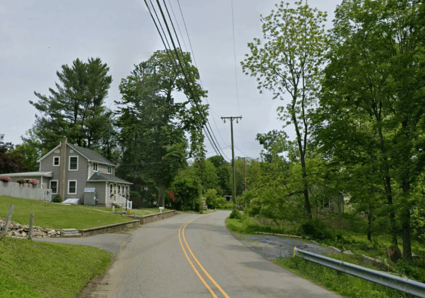
Greendell counts roughly six hundred residents scattered across former rail-line lots now enveloped by forest. Rail history buffs explore the old Lackawanna Cut-Off station platform, while hikers climb nearby Allamuchy Mountain’s northern shoulder for panoramic views.
Family-run dairies, maple-syrup operations, and home-based tech jobs share the local economy. Multi-acre zoning keeps neighbors far apart and retail hubs more than ten miles away, muting any hint of suburban hustle.
The disused railbed serves as an informal walking path where fox tracks outnumber human footprints. Come fall, locals meet at the Volunteer Firehouse for a chili cook-off unknown to most outsiders.
Where is Greendell?
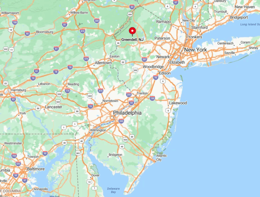
Located in Sussex County, Greendell lies about four miles northwest of Tranquility and ten miles from Route 80’s Allamuchy exit. County Route 611 leads in, passing abandoned dairy barns and forested wetlands before reaching the hamlet.
Limited shoulder width and deer crossings slow traffic to country-road speed. NJ Transit once served the area but pulled tracks decades ago, reinforcing the village’s off-the-grid position.
2. Mount Hermon, Blairstown Township

Mount Hermon hosts an estimated two hundred residents living in stone cottages and hilltop horse farms. Popular pastimes include picking apples at Ledgewood Orchard, spotting hawks from the ridge, and hopping onto the Appalachian Trail a mile to the west.
Small-scale equine boarding, agritourism, and remote employment sustain the local tax base. Thick maple stands line dirt lanes that climb toward the ridge, muffling sound and hiding houses from road view.
Darkness arrives early as the sun dips behind the Kittatinny crest, and high-speed internet reaches the area only through fixed wireless towers. A century-old schoolhouse repurposed as a community center hosts sporadic bluegrass jams that draw musicians from two states.
Where is Mount Hermon?
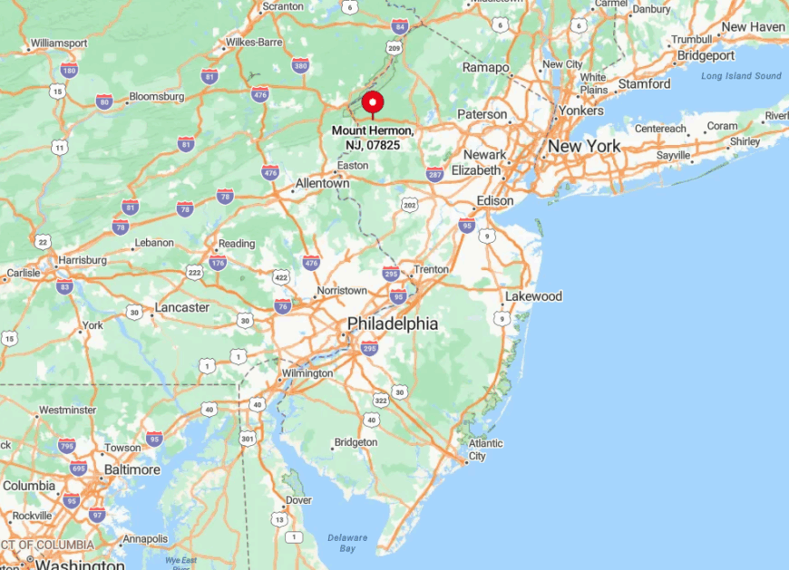
This hillside hamlet sits in Warren County, three miles north of Blairstown’s main street and about eight miles east of the Delaware River. Access comes via Mount Hermon Road, a switch-backed climb that turns to gravel for its final stretch.
Winter ice or fallen limbs often block the ascent, so locals keep chainsaws and tow straps handy. The nearest commuter bus stop is in Blairstown, leaving most residents reliant on all-wheel-drive vehicles.
1. Vail, Hardwick Township
Vail claims roughly eighty year-round residents amid fieldstone farmhouses and broad hayfields. Anglers cast for wild trout in the Upper Paulins Kill, cyclists pedal empty county lanes, and history buffs tour the restored 1812 Vail Grist Mill on summer Sundays.
Hay production and niche livestock such as heritage-breed sheep form the modest agricultural economy, supplemented by remote professionals seeking pastoral views. Hidden at the end of narrow lanes with no through traffic, the hamlet backs onto state-protected woodlands that block light and noise from neighboring towns.
Evenings bring an unbroken chorus of tree frogs, and the Milky Way is easily visible overhead. Local legend says the valley’s hush convinced early telegraph inventor Alfred Vail’s relatives to settle here, lending their name to the area.
Where is Vail?
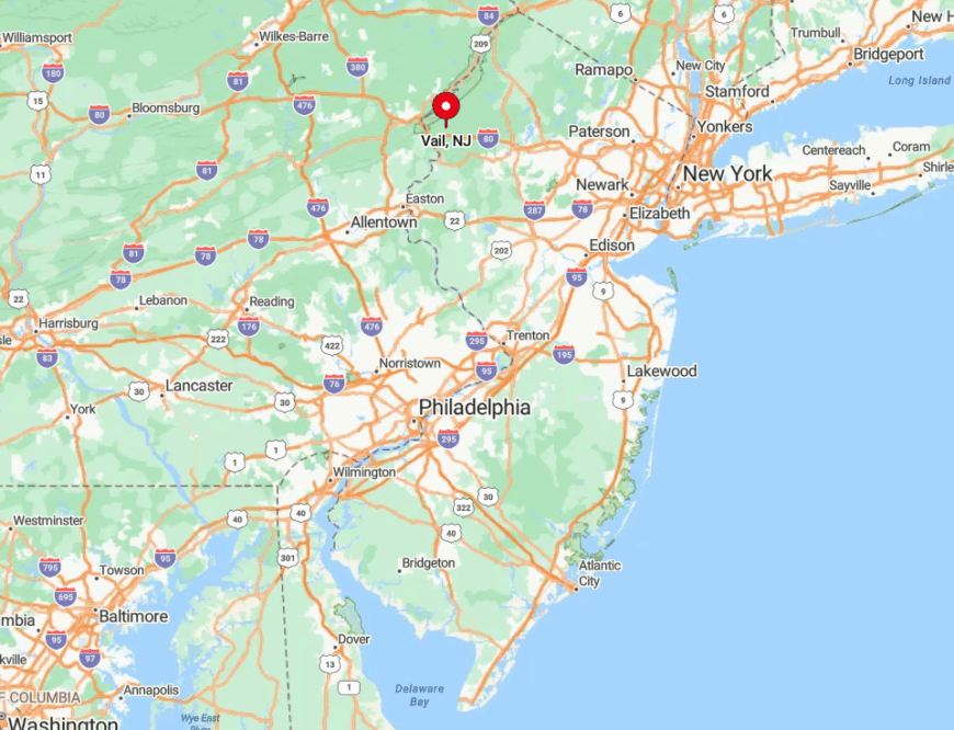
Vail nestles in the Upper Paulins Kill Valley of Warren County, about six miles west of Johnsonburg and ten miles north of Route 80’s exit at Hope. Drivers follow dimly marked County Route 521 before turning onto Vail Road, a paved lane that narrows to tar-and-chip as it dips into the valley.
No public transit or ride-share reaches the hamlet; visitors must come by car or, for the adventurous, by bicycle from the Paulinskill rail-trail spur. The surrounding state wildlife management areas ensure that even future development will remain distant, preserving Vail’s rare quiet for years to come.


