Would you like to save this?
The high country north of the White Mountains is a pocket of New Hampshire that many residents of the southern part of the state have never seen. Here, rivers still rule the valleys, gravel logging roads outnumber paved streets, and the silence after dusk feels almost foreign to ears trained on traffic.
We invite readers to picture evenings when loons call across glassy lakes, mornings when mist slips through notches cut by glaciers, and afternoons framed by clapboard villages that measure time in decades rather than hours.
These 25 mountain towns and unincorporated townships sit far from shopping plazas and interstate exits, yet they hold more outdoor possibilities than many better-known destinations.
Counting down from the southern edge of the list to the state’s northernmost tip, our guide highlights what makes each spot special and how to reach it without losing the sense of discovery that seclusion provides. Pack a map, keep an eye out for moose, and step into the quiet side of New Hampshire.
25. Dalton’s Riverbank Silence

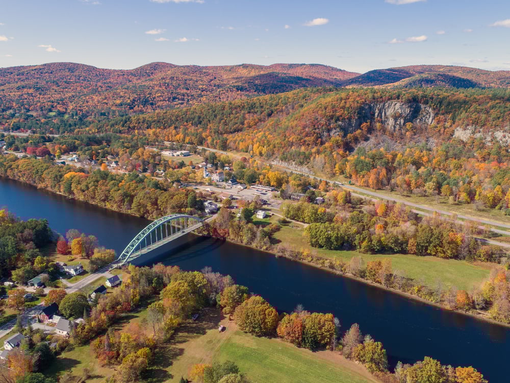
Tucked deep in New Hampshire’s North Country, Dalton rests between dense forests and the bends of the Connecticut River, far from the chatter of highways and the glare of city lights. With fewer than a thousand residents and miles of unpaved roads, it feels like a place time quietly forgot.
The air carries the scent of pine and woodsmoke, and most days pass with little more than the rustle of wind through trees or the call of a loon from a nearby pond. Life moves at the pace of nature—people hike nearby Mount Weeks, fish in Forest Lake, or browse antiques in old barns scattered along backroads.
Winter draws snowshoers and skiers, while fall ignites the hills in gold and crimson. Many locals farm, work in forestry, or have retired into the rhythms of the land. It’s the kind of place that invites you to sit still, breathe deep, and remember what quiet really feels like.
Where is Dalton?

Dalton, New Hampshire sits in the northwest corner of the state, nestled between forested hills and the Connecticut River. It’s about 15 miles west of Littleton, accessible by quiet local roads that weave past farms and through wooded stretches.
Reaching Dalton means leaving behind the hum of highways and following country routes that grow stiller with each bend. It’s a place where the mountains hush the noise, and the stillness settles in.
24. Lyman’s Forgotten Hollows

There’s a quiet in Lyman that you don’t find many places anymore—the kind that settles over the hills and lingers between the trees. Surrounded by forested ridges and far from any highway rush, this tiny town of fewer than 600 feels tucked away from the modern world.
The vibe is simple and old New England—weathered barns, gravel roads, and skies untouched by light pollution. Locals find their rhythm in nature: canoeing on Dodge Pond, walking wooded trails, or gathering maple syrup in spring.
Autumn arrives with a blaze of color, while winters hush the land with deep snow. Small-scale farming, home-based work, and quiet living define the pace here. It’s the kind of place that doesn’t just offer peace—it insists on it.
Where is Lyman?

Lyman, New Hampshire rests in the upper western hills of the state, tucked just southeast of the Connecticut River Valley. Located about 20 miles southwest of Littleton, it’s reached by winding back roads that pass through meadows, forests, and scattered homesteads.
The drive is quiet, with narrow lanes and the occasional deer crossing, gradually pulling you away from towns and traffic. It’s the kind of place where the silence feels intentional, like the land asked to be left alone.
23. Stratford’s Ridge-Rimmed Silence

Stratford rests in the northern reaches of Coös County, where the mountains rise high and cell signals fade into the trees. Cradled by dense forest and stretched along the Connecticut River, it’s far from major roads and even farther from the rhythms of city life.
With just over 700 residents scattered across hills and valleys, the town feels quiet, self-contained, and deeply rooted. Life here is rugged and peaceful—locals snowmobile the old logging trails, fish in wild streams, or walk the winding roads past 19th-century homes and general stores.
In autumn, the foliage turns the hills to fire; in winter, the snow hushes every sound. Many work in forestry, seasonal tourism, or simply stay for the solitude. It’s the kind of place that makes you feel small in the best way—like the land itself is holding the silence for you.
Where is Stratford?

Would you like to save this?
Stratford, New Hampshire lies in the remote northern stretch of the state, nestled between the Connecticut River and the wooded slopes of the North Country. It’s roughly 35 miles north of Lancaster, reached by Route 3 as it winds past riverbanks, old barns, and shadowed forest.
The drive grows quieter the farther you go, with only the sound of tires on asphalt and the rustle of trees overhead. It’s a place where the road narrows and the sky opens wide, offering seclusion in every direction.
22. Randolph’s Mountain Pass Quietude

Perched along the slopes of the Northern Presidential Range, Randolph feels like a quiet lookout above the rest of the world. Surrounded by the White Mountain National Forest and home to fewer than 400 residents, it’s a place where thick woods, winding roads, and towering ridgelines create a natural barrier to modern life.
The town is peaceful and contemplative—marked by rustic cabins, forest trails, and a long tradition of hikers who come not for noise, but for the silence between birdsong and breeze. Days are spent walking the Presidential Rail Trail, exploring waterfalls, or stargazing under skies untouched by city light.
The Randolph Mountain Club keeps local hiking history alive, and neighbors gather in seasonal rhythms rather than daily routine. Most residents are retirees, remote workers, or long-time locals who live by the seasons. It’s the kind of place where the mountains don’t just surround you—they hold you.
Where is Randolph?

Randolph, New Hampshire is tucked into the northern White Mountains, just east of Jefferson and perched along the base of the Presidential Range. Located about 10 miles west of Gorham, it’s reached via U.S. Route 2, a scenic two-lane road that hugs the mountains and winds through deep forest.
The journey brings you beneath towering peaks and past trailheads where the trees crowd close to the road. It’s a quiet stretch of wilderness where the mountains seem to shield you from the world.
21. Columbia’s Wild Corridor

Hidden in the northernmost stretch of the Connecticut River Valley, Columbia is a place where the roads narrow, the forests deepen, and life moves to the rhythm of the land. With just over 700 residents and miles between neighbors, it feels far removed from the pace of the outside world.
The landscape is a quiet mix of working farms, rolling fields, and dense woods that stretch toward the Canadian border. Locals spend their time fishing the river, snowmobiling through backcountry trails, or picking up goods at old roadside farm stands.
Fall colors arrive with quiet brilliance, and winters settle in like a blanket, deep and still. Farming and forestry anchor the local economy, but many stay simply for the solitude. It’s the kind of place where the silence isn’t empty—it’s full of everything that matters.
Where is Columbia?

Columbia, New Hampshire stretches along the northern edge of the state, tucked between the Connecticut River and the rolling forested hills of the Great North Woods.
About 30 miles north of Lancaster, it’s reached by Route 3, where the road slips past old farmsteads and into long stretches of untouched wilderness. The drive is quiet and steady, with more trees than traffic and long views over open fields. It’s the kind of place where the land feels wide and time feels slow.
20. Jefferson’s Hidden Meadows

Tucked between the White Mountains and the Kilkenny Range, Jefferson feels like it’s been carved out of a quieter time. Surrounded by sweeping views, dense forest, and open farmland, the town sits far from major highways, with just a few hundred residents scattered along winding roads.
There’s a stillness here that settles in with the fog and lingers under the starlit sky. Locals spend their days hiking in Pondicherry Wildlife Refuge, biking rural backroads, or visiting the old Waumbek Hotel grounds where history still whispers through the grass.
In the summer, small festivals and farmstands bring neighbors together; in winter, snowshoe tracks crisscross the fields. Some make a living from farming or small inns, while others simply stay for the space and silence. It’s the kind of place that reminds you just how far away the rest of the world can feel.
Where is Jefferson?

Jefferson, New Hampshire rests in the northern part of the state, nestled between the White Mountain peaks and the open stretches of the Upper Ammonoosuc River Valley. It’s about 15 miles east of Littleton, reached by a series of rural highways that roll gently through farmland and forest.
The route offers glimpses of Mount Washington in the distance, growing quieter as you approach. It’s a town where the mountains feel close enough to touch, and everything else feels far away.
19. Kilkenny’s Wilderness Slopes

Kilkenny isn’t just off the beaten path—it’s almost off the map. Once a small logging settlement, it’s now an unincorporated, uninhabited township swallowed by the White Mountain National Forest.
There are no paved roads, no permanent residents, and no streetlights—just endless stretches of forest, mountain ridges, and the soft hush of wind through the trees. Hikers pass through on trails like the Kilkenny Ridge Trail, climbing summits like Mount Cabot and The Horn, while backcountry campers seek out its untouched silence.
Wildlife outnumbers people, and the only structures are forgotten cellar holes and remnants of a town that nature reclaimed long ago. There’s no industry here anymore—only solitude, wilderness, and the echoes of what once was. It’s the kind of place where the silence feels ancient, and the forest remembers everything.
Where is Kilkenny?

Kilkenny, New Hampshire is hidden deep within the White Mountain National Forest, an unincorporated township tucked between the rugged ridgelines of the Pliny and Pilot Ranges. Located about 25 miles northeast of Littleton, it’s reached only by forest roads and hiking trails that weave through dense, untamed wilderness.
There are no main roads or town centers—just thick woods, old logging paths, and the quiet hum of wind through spruce. It’s a place so remote it doesn’t appear on many maps, where seclusion isn’t a feeling—it’s the way of life.
18. Carroll’s Highland Divide

Nestled between the towering peaks of the White Mountains and the shadow of Mount Washington, Carroll feels gently hidden in plain sight. Though U.S. Route 302 winds nearby, dense forests and wide open valleys give the town a sense of separation from the world beyond.
With just over 800 residents, it’s a quiet place where life centers around the land—marked by historic inns, winding backroads, and the ever-present hum of wind through pine. Visitors hike to Arethusa Falls, wander through the woods of Crawford Notch, or take in sweeping views from the Mount Washington Hotel grounds.
Winters draw snowshoers and cross-country skiers into the woods, while fall sets the hills ablaze with color. Tourism and hospitality support the local economy, but the true wealth here lies in the stillness. It’s the kind of place where time slows down—and stays there.
Where is Carroll?

Carroll, New Hampshire lies in the heart of the northern White Mountains, nestled between Twin Mountain and Bretton Woods with sweeping views in all directions. It’s about 20 miles east of Littleton, reached by U.S. Route 302 as it winds through mountain passes and along forested ridgelines.
The road in is flanked by trees and quiet trailheads, where the traffic thins and the air grows cooler. It’s a town where the wilderness begins just beyond the doorstep, and solitude feels like part of the landscape.
17. Stewartstown’s Ridge Country Crossroads

High in New Hampshire’s northern reaches, Stewartstown sits close to the Canadian border, where the mountains roll endlessly and the roads turn to gravel. This remote town, with fewer than 1,000 residents, feels far from everything—surrounded by forest and dotted with old farmhouses.
The air carries the scent of pine and woodsmoke, and silence stretches wide between neighbors. Locals ride ATVs along wooded trails, fish in the Connecticut River headwaters, or visit the old Stewartstown Hollow Church that stands quietly beneath the hills.
Winters are long and still, with snow that softens every sound and slows the pace of life. Logging, farming, and seasonal tourism remain steady anchors, though many stay simply for the space and solitude. It’s the kind of place where the world feels paused—and you’re in no rush to press play.
Where is Stewartstown?

Stewartstown, New Hampshire sits near the northernmost tip of the state, bordered by Canada and blanketed by the quiet forests of the Great North Woods. It’s about 40 miles north of Lancaster, reached by Route 3 as it climbs steadily through remote countryside and past scattered farms.
The journey brings you deeper into a landscape where roads narrow, towns fade, and nature takes over. It’s a place where the quiet feels endless, and the outside world feels a lifetime away.
16. Clarksville’s High Country Stillness

Would you like to save this?
Tucked into the far northern corner of New Hampshire, Clarksville is the kind of place where the wilderness begins at your doorstep and the rest of the world feels far away. With fewer than 300 residents and miles of rugged terrain in every direction, it’s surrounded by deep forest, quiet hills, and lakes that reflect nothing but sky.
The town feels timeless—no stoplights, no rush, just dirt roads, old homesteads, and the steady rhythm of nature. Locals spend their days fishing in Lake Francis, riding snowmobiles along backcountry trails, or hunting deep in the woods.
In autumn, the trees ignite in color; in winter, the snow settles thick and undisturbed. Small-scale logging and seasonal recreation help sustain the local pace. It’s the kind of place where solitude isn’t rare—it’s the way of life.
Where is Clarksville?

Clarksville, New Hampshire sits in the far northern reaches of the state, nestled in the rolling forested hills between the Connecticut River Valley and the border with Canada. It’s located about 40 miles north of Lancaster, reached via Route 3 followed by a quiet secondary road that winds through patchwork woods and pastoral clearings.
The drive becomes increasingly hushed as roadside farms give way to dense pine stands, and signs of civilization fade into the distance. It’s a spot where the trees seem to close in around you, and solitude feels as natural as the mist drifting through the valleys.
15. Bath’s Overlooked Farm Lanes

Nestled along the banks of the Ammonoosuc River, Bath feels quietly preserved—shielded by forested hills and far from the buzz of modern highways. The town has fewer than 1,000 residents and a village center anchored by one of the oldest general stores in America.
Covered bridges span the river, and time seems to slow as you walk past weathered homes and stone walls. Locals hike forest trails, swim in the river, or visit the iconic Brick Store for a bite and a bit of history.
In autumn, the covered bridges frame a cascade of red and gold; in winter, snow softens every edge. Tourism, small farms, and crafts support the local pace, but it’s the quiet that keeps people close. It’s the kind of place where the past lingers—and you don’t mind staying a while with it.
Where is Bath?

Bath, New Hampshire rests in the northwest corner of Grafton County, near the Connecticut River and just 25 miles north of Littleton. It’s reached via U.S. Route 302 or Route 10, where the road winds through quiet valleys and over historic covered bridges.
The drive slips past riverbanks and wooded hills, growing more peaceful with every turn. It’s a place where time moves gently, and quiet feels built into the landscape.
14. Northumberland’s Forgotten Fields

Cradled by the Connecticut River and backed by forested hills, Northumberland sits quietly in the northern edge of Coös County, far from the hum of cities and interstate highways.
With just over 2,000 residents and a layout that blends village charm with stretches of open land, the town feels gently tucked away from the world’s rush. The air is filled with the scent of pine and woodsmoke, and the days move slowly past historic homes and quiet fields.
Locals fish along the riverbanks, hike the nearby Nash Stream Forest, or gather at the village center where time seems to idle. Autumn turns the hills brilliant, while winter cloaks everything in a deep, familiar stillness.
Once supported by railroads and paper mills, the town now leans on small business, agriculture, and resilience. It’s the kind of place where the quiet doesn’t feel empty—it feels like home.
Where is Northumberland?

Northumberland, New Hampshire is situated in western Coös County along the Connecticut River, just north of Lancaster in New Hampshire’s sparsely populated Great North Woods region. It lies about 7 miles northeast of Lancaster and roughly 130 miles north of Concord, reached via U.S. Route 3 as it winds along the Connecticut River through dense spruce and maple forests.
Route 3 as it winds alongside the river and through a landscape of dense spruce and maple. The drive leaves U.S. 3 at Groveton and follows quieter back roads through farmland and forested patches, and as you go the traffic thins and signals fade into the pine canopy.
It’s a place where the river murmurs softly and the forests seem to hold their breath—close enough to drive to, but far enough to feel the world recede.
13. Lancaster’s Edge of the Range

Set along the Connecticut River with the White Mountains rising nearby, Lancaster feels like a gateway to the North Country—yet still quietly tucked away from the world’s faster pace. Though it’s the shire town of Coös County, its rural setting, mountain views, and old brick storefronts give it the feel of a place both grounded and remote.
The downtown is small but full of history, where timeworn buildings line peaceful streets and church bells mark the passing hours. Residents hike Weeks State Park, kayak the river, or explore the old fairgrounds where local festivals still carry a nostalgic charm.
Fall brings a blaze of color, and winter lays a deep hush over the land. Small businesses, farming, and tourism support the town’s rhythm, but the real draw is its balance of solitude and community. It’s the kind of place where you feel both rooted and removed—held gently in a slower moment.
Where is Lancaster?

Lancaster, New Hampshire sits in the northern part of Coös County, along the eastern bank of the Connecticut River and surrounded by forested hills and farmland. It’s about 95 miles north of Concord, reached via U.S. Route 3 and Route 2 as the roads narrow and the scenery grows more remote.
The drive winds through quiet river valleys and rolling terrain, far from city lights. It’s the kind of place where the world feels slower, and the stillness settles in around you.
12. Dummer’s River Curve Refuge

Tucked between the Androscoggin River and the northern edge of the White Mountains, Dummer is a place where wilderness sets the pace. With fewer than 300 residents and no true town center, it’s surrounded by forest, rolling hills, and long, quiet stretches of road that feel far from anywhere.
The landscape is raw and peaceful—logging roads weave through dense woods, and wildlife is more common than neighbors. Locals spend their days fishing in the river, exploring the nearby Pontook Reservoir, or riding ATVs and snowmobiles along old trails.
Fall lights up the hills in gold and rust, while winter brings silence under deep snow. Logging remains a steady part of life here, along with seasonal recreation. It’s the kind of place where nature speaks louder than people—and that’s exactly why some choose to stay.
Where is Dummer?

Dummer, New Hampshire is a small town in eastern Coös County, nestled within the Great North Woods beside the Androscoggin River and Pontook Reservoir. Tucked roughly 20 miles east of Lancaster and about 25 miles north of Milan, it sits amid rolling hills and dense forest.
To reach it, you travel north on Route 16, then turn onto quiet country roads winding past riverbanks and through pine and maple woods—cell service fades and homes become scarce. It’s a place where the forest hushes the world, and solitude isn’t just discovered—it’s the reason you came.
11. Monroe’s Riverbend Stillness

Perched along the Connecticut River with forested hills rising behind it, Monroe feels like a quiet bend in time. With fewer than 900 residents and only a few main roads, it’s easy to miss—and that’s part of its charm.
The town is calm and unhurried, where river mist hangs in the mornings and birdsong carries across open fields. Locals fish the Connecticut, hike along woodland paths, or gather at the old town hall that still hosts community events.
Autumn turns the valley into a canvas of gold, and winter wraps the town in a deep, soft stillness. A mix of farming, forestry, and rural tradition supports the way of life here. It’s the kind of place that asks nothing of you—except to slow down and stay awhile.
Where is Monroe?

Monroe, New Hampshire sits along the Connecticut River in western Grafton County, just across from Barnet, Vermont. It’s about 30 miles north of Littleton, reached via local roads branching off U.S. Route 302 and Route 135.
The route winds past reservoirs, forests, and farmland, growing quieter with each mile. It’s a place where the river runs slow and the stillness feels complete.
10. Wentworth Location’s Androscoggin Vistas

Wentworth Location is home to roughly 50 year-round residents who wake to the sight of the Androscoggin River twisting below Rum Mountain. Canoeing the wide river bend, casting for brook trout in the smaller tributaries, and cycling along North Road give visitors plenty to do in a place without a single traffic light.
Seasonal maple operations and small-scale forestry share the economic stage with wilderness tourism, all on parcels large enough that neighbors remain out of sight. Seclusion comes from the fact that the township is bordered by state forest on one side and the river on the other, leaving only local roads for access.
A lesser-known gem is the short scramble up Blueberry Mountain, where late-July hikers gather enough fruit to stain their fingers for days.
Where is Wentworth Location?

The township sits in Coös County, just south of the Maine border, tucked between the towns of Errol and Milan. Thick spruce and fir stands buffer it from Route 16, so engine noise never reaches the riverbank homes.
Drivers aiming for the Wentworth Location turn off Route 16 onto North Road and follow the Androscoggin for six quiet miles. The closest full-service grocery is 25 minutes away in Berlin, which helps the area keep its unhurried pace.
9. Odell’s Forested Plateaus

Only about 15 people keep addresses in Odell, a nearly forgotten township filled with old logging grades and deep spruce-fir lowlands. Paddling the beaver-dammed ponds, bushwhacking to unnamed trout brooks, and snowshoeing along the Cohos Trail offer adventure without crowds.
Timber harvesting remains the primary industry, though it runs on long rotations that leave years of silence between cuts. Odell’s sense of isolation stems from its web of gated roads that limit casual traffic and preserve dark skies. An insider tip is to visit Round Pond at dawn, when fog lifts to reveal mirrored firs against the water.
Where is Odell?

Odell lies west of Route 3 between Groveton and Pittsburg, but no state highway crosses its interior. The township is ringed by Dillon, Pond, and Blue Mountains, which hide it from the wider world.
Access requires a high-clearance vehicle on Nash Stream Road, a gravel byway maintained mainly for timber trucks. Winter arrivals often swap wheels for snowmobile tracks that tie into the state’s extensive corridor trail system.
8. Success’s Quiet Foothills

Success records zero permanent residents on most census tallies, though a handful of seasonal camp owners swell the count on summer weekends.
Visitors hike the Mahoosuc Trail to the 3,565-foot summit of Mount Success, explore overgrown apple orchards left by 19th-century settlers, and track moose through fern-filled clearings. With no commercial activity beyond periodic logging, the land sits in quiet transition between forest cycles.
The absence of utility lines beyond the entrance gate and a lack of cell service magnify the feeling of being off the clock. A little-known curiosity is the granite foundation of an old fire warden cabin, perfect for lunchtime picnics with sweeping valley views.
Where is Success?

Success occupies a wedge of land east of Berlin, pressed against the Maine border and shadowed by the Baldcap Peaks. The only maintained access is Success Pond Road, a 25-mile dirt track that starts in Berlin and ends near Grafton Notch State Park in Maine.
Deep ditches and frost heaves discourage casual sedans, which keeps foot traffic low on the surrounding trails. Winter travel shifts to snowmobiles, giving cold-weather explorers an unbroken corridor through fresh powder.
7. Cambridge’s Umbagog Backwoods

Roughly 70 residents share Cambridge’s 50 square miles of hills and lakefront shoreline, leaving ample elbow room for wildlife and visitors alike. Days start with drift-boat rides on the Androscoggin River, move to loon spotting on Lake Umbagog, and finish with telescope sessions under a sky free of light pollution.
Small hay farms, family forestry lots, and cottage rentals anchor the local economy. Seclusion holds because no state highway bisects the township, and cell towers never made it past the planning stage. A hidden bonus is Deer Mountain Fire Tower, where a short climb earns views stretching into Maine and Quebec.
Where is Cambridge?

Cambridge sits just northeast of Errol, bordered by Lake Umbagog to the north and the Androscoggin River to the south. Travelers reach it via Routes 16 and 26, then branch onto gravel Little Bear Road or Dam Road, depending on their destination.
Dense second-growth forest muffles noise, while long stretches between homesteads ensure true nights. Four-wheel drive proves handy in mud season, but summer bicyclists often tackle the same roads on wider tires.
6. Beans Purchase’s Backcountry Trailheads

Beans Purchase lists a population in the single digits, though the trail registers at South, Middle, and North Carter Mountains collect hundreds of signatures each season. Backpackers step off the Rattle River Trail, birders linger in maple glades below Mount Moriah, and anglers sneak casts into the Peabody River tributaries.
The township’s economic activity is limited to timber sales brokered by large landowners and the occasional Appalachian Trail hiker spending in nearby Gorham.
Physical remoteness comes from the maze of Forest Service roads that require careful navigation and sometimes a locked gate key. An overlooked delight is the spring wildflower bloom along Townline Brook, where trout lilies carpet the forest floor.
Where is Beans Purchase?

This unincorporated grant lies just north of Pinkham Notch, wedged between Mount Moriah on the west and the Wild River Wilderness to the east. Access points include Hogan Road from Route 16 and the gravel Dolly Copp Road, both subject to seasonal closures.
With the White Mountain National Forest covering most of the acreage, house lights are practically nonexistent after dusk. Visitors often arrange rides from Gorham, eight miles south, to avoid leaving low-clearance cars on rough shoulders.
5. Millsfield’s Moose Country Plateau

About 25 residents call Millsfield home, their clapboard houses scattered across rolling meadows rich in blueberries each July. Four-wheeling the Phillips Brook Trail, paddling Millsfield Pond at daybreak, and scanning logging cuts for bull moose fill itineraries here.
The local economy revolves around selective logging and seasonal cabin rentals that appeal to hunters in October and snowmobilers in February.
Millsfield feels remote because it sits on a high plateau separated from neighboring towns by ridgelines that block radio and cell signals. In-the-know photographers catch the sunrise from Akers Pond Overlook, a pull-off few guidebooks mention.
Where is Millsfield?

Millsfield is fifteen miles south of Errol along Route 26, but much of the township lies beyond that pavement on dirt arteries like Millsfield Pond Road. The plateau’s elevation keeps winter snow deep, which slows travel and preserves a hushed landscape.
Visitors coming from the south crest Dixville Notch before dropping into the valley, a drive that sets a scenic tone. Gas and groceries require a run to Colebrook, a half-hour to the west, so planning ahead is wise.
4. Stark’s Covered-Bridge Hollow

Stark hosts around 550 residents clustered near the Ammonoosuc River, watched over by a white-steepled church and a 19th-century covered bridge that photographers love.
Popular pursuits include climbing Rogers Ledge for sweeping valley panoramas, fishing the Upper Ammonoosuc for landlocked salmon, and browsing the summer farmers market on the common.
Small dairy farms and craft woodshops provide most of the local income, supplemented by a trickle of hikers from the nearby Kilkenny Ridge Trail.
Stark’s isolation comes from the surrounding Mahoosuc and Pliny Ranges, which funnel drivers onto a single state road and leave the rest of the valley to silence. A little-known site is Devil’s Slide, a mossy cliff band where peregrine falcons nest each spring.
Where is Stark?

Stark lies northwest of Berlin along Route 110, yet once past the village, the road narrows and cell service fades. The closest big box store sits an hour away in Littleton, reinforcing the sense of distance.
Travelers arriving from Interstate 93 wind over the Presidential Range via Route 2 before turning north into the valley. Snowmobile Corridor Trail 5 crosses the bridge in winter, offering another approach when roads are slick.
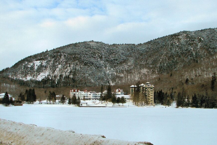
3. Dixville Notch’s Dramatic Pass Hamlet

Dixville’s permanent population hovers near a dozen, most living in historic lodges beneath the sheer granite walls of the notch. Ice-climbing the winter waterfalls, kayaking the swift Cold River, and leaf-peeping from Table Rock make the short activity list long on scenery.
The mothballed Balsams Resort hints at past grandeur, while present-day jobs focus on hospitality projects tied to its future reopening. Physical seclusion results from 3,000-foot peaks wrapping around the narrow pass, leaving only Route 26 to connect east and west.
Few travelers realize that within a ten-minute walk from the highway, they can reach Huntington Cascade, a two-tier waterfall hidden by dense spruce.
Where is Dixville Notch?

The hamlet straddles Route 26 between Colebrook and Errol, roughly five miles east of Colebrook’s Main Street. Sharp turns, steep grades, and winter ice keep traffic modest, especially after dark.
State park boundaries on all sides halt development, maintaining an unbroken sweep of forest. Public parking at Dixville Notch State Park serves as the trailhead for both Table Rock and the Cohos Trail.
2. Errol’s Umbagog Wilderness Gateway

Errol counts about 275 full-time residents who share a riverside grid of streets just wide enough for passing trucks. Days revolve around paging loons on Lake Umbagog, rafting the Class II rapids of the Androscoggin, and sampling smoked cheddar at the trading-post style general store.
Small outfitters, a power-equipment dealership, and family-run lodging make up the town’s modest economy. Remoteness lingers because the nearest traffic signal sits 30 miles south in Berlin, and large tracts of conserved land encircle the village.
A tucked-away gem is the Aziscohos Mountain Trail, where a steep mile leads to a granite bald with 360-degree views into Maine.
Where is Errol?

Positioned at the junction of Routes 16 and 26, Errol stands as the last fully serviced town before the Maine border. Dense forests and Umbagog National Wildlife Refuge prevent any side-road shortcuts, funneling all arrivals through the village center.
Concord-bound buses stop nearly 90 miles away, so visitors usually arrive by car or motorcycle. Once in town, paddlers can launch within walking distance of the post office and slip into the wilderness within minutes.
1. Pittsburg’s Lakes-and-Peaks Retreat

Pittsburg supports roughly 800 residents scattered across 291 square miles, making it New England’s largest township by area yet one of its least crowded. Boaters explore four Connecticut Lakes, anglers chase landlocked salmon below Murphy Dam, and hikers summit Mount Magalloway for views that reach into Canada.
Tourism, logging, and maple production form the economic trio that keeps the town running without changing its character. Seclusion stems from being the final community before the Canadian border, with long stretches between homesteads and only two gas pumps over 27 miles of Route 3.
A lesser-known treat is Scott’s Bog, where sunrise fog curls above pitcher plants and snapping turtles cruise beneath the peat-stained water.
Where is Pittsburg?

Pittsburg begins 15 miles north of Colebrook and runs to the border crossing at Chartierville, Quebec. The nearest interstate exchange is more than an hour and a half south in Littleton, keeping casual weekenders at bay.
Travelers reach town on Route 3, sometimes sharing the pavement with moose that wander from roadside salt licks. Seasonal back roads like Cedar Stream turn into snowmobile highways in winter, providing deep-woods access once the lake effect snow piles high.