Would you like to save this?
Counties with the shortest life expectancy in Tennessee
Life expectancy can be affected by a variety of factors. About 25% of your lifespan is determined by genetics, according to the National Library of Medicine. Health and wellness habits—like following a balanced, nutrient-rich diet; not smoking; drinking minimal alcohol; maintaining a healthy weight; and staying physically active—can add more than a decade to your life, research from the National Institutes of Health shows. While these factors are significant, another important element that you might not have considered is your environment and community.
While life expectancy generally increases annually in the United States—jumping from about 70.8 years old to 77.5 between 1970 and 2022, according to the Centers for Disease Control and Prevention—this particular metric can vary from state to state or even county to county. In some parts of the country, the average lifespan is getting shorter based on a variety of risk factors on top of health, including socioeconomic factors like poverty, unemployment, income, and education.
According to a 2020 study from researchers at Penn State, West Virginia, and Michigan State Universities, communities with a higher population density, more fast food restaurants, and a high number of extraction industry-based jobs tend to have shorter life expectancies.
To find out how life expectancy varies within Tennessee, Stacker used 2024 County Health Rankings & Roadmaps from the University of Wisconsin Population Health Institute to identify the counties with the shortest life expectancy. Life expectancy measures the average number of years from birth a person can expect to live and is calculated based on the number of deaths in a given time period and the average number of people at risk of dying during that period. Counties with unreliable or insufficient data were excluded from the analysis. Mortality data came from the National Vital Statistics System.
Read on to see if your county is on the list.
You may also like: Counties with the longest life expectancy in Tennessee
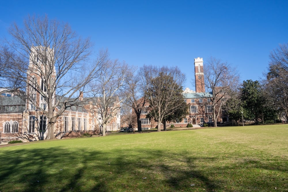
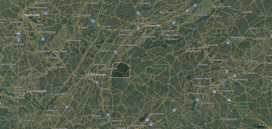
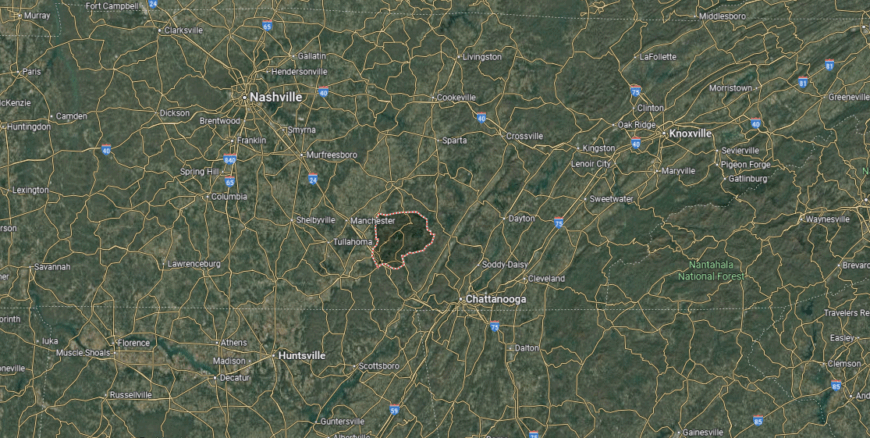
#48. Coffee County
– Life expectancy: 72.9 years
— 1.2 years lower than the state average
About
Coffee County, Tennessee, reflects a strong agricultural base blended with a growing presence of industry and commerce. Its communities are shaped by a mix of historic town centers, farmland, and natural landscapes that tie residents closely to place. The county’s character balances rural tradition with modern development, offering both stability and adaptability.
Residents come together through seasonal festivals, school events, and recreational activities in the county’s rivers and forests. Daily life follows a steady rhythm that values generational ties, local pride, and shared well-being. Coffee County stands as a living example of Tennessee’s enduring rural spirit and community strength.
Where is Coffee County?
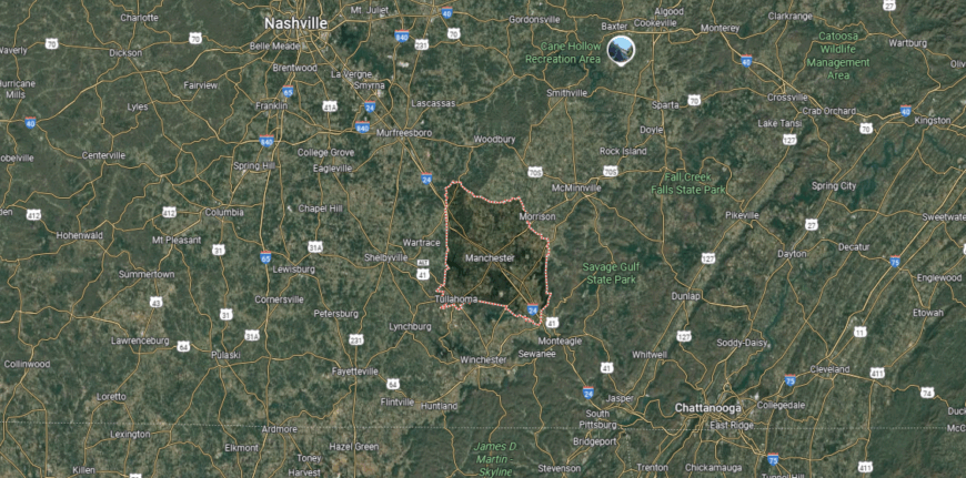
Coffee County is in south-central Tennessee, bordered by Cannon County to the north, Franklin County to the south, and Bedford County to the west. The county is situated about 65 miles southeast of Nashville and 75 miles northwest of Chattanooga. It stretches across the I-24 corridor, connecting the Highland Rim with the Cumberland Plateau.
Manchester, the county seat, lies near the geographic center and serves as a key crossroads. Tullahoma, the largest city, is positioned in the southern part close to the Franklin County line. Smaller communities such as Hillsboro and Beechgrove add to the county’s mix of farmland, rolling hills, and wooded terrain.
#47. Lincoln County (tie)
– Life expectancy: 72.8 years
— 1.3 years lower than the state average
About
Lincoln County sits at the crossroads of Tennessee’s agricultural heritage and southern foothill landscapes. Its communities are rooted in traditions of farming, craftsmanship, and local trade, with small towns that preserve a sense of continuity across generations. Rolling fields, quiet ridges, and historic landmarks give the county a grounded yet distinctive presence.
Civic life is shaped by community fairs, courthouse gatherings, and events that bring neighbors together in shared celebration. Families maintain close ties to the land while also looking toward new opportunities in education and local enterprise. Lincoln County stands as a place where history, work, and community pride remain deeply connected.
Where is Lincoln County?
Lincoln County is positioned along Tennessee’s southern border with Alabama, framed by Bedford County to the north and Giles County to the west. It lies roughly 80 miles south of Nashville and 30 miles north of Huntsville, Alabama. The terrain is defined by rolling farmland, wooded ridges, and the Elk River winding through its valleys.
Fayetteville, the county seat, sits near the center and serves as the hub of government and commerce. Smaller towns such as Petersburg to the north and Flintville near the Alabama line contribute to its rural character. The county’s location makes it a gateway between Middle Tennessee and northern Alabama, balancing agricultural roots with cross-border connections.
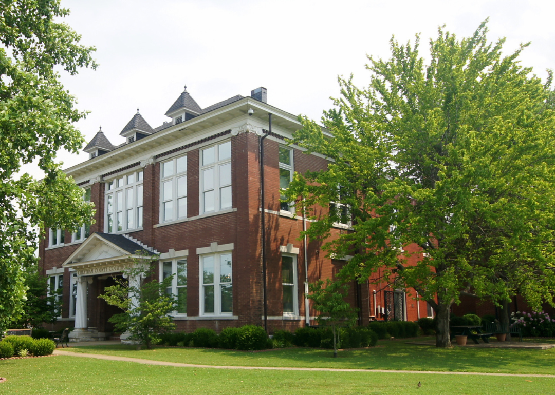
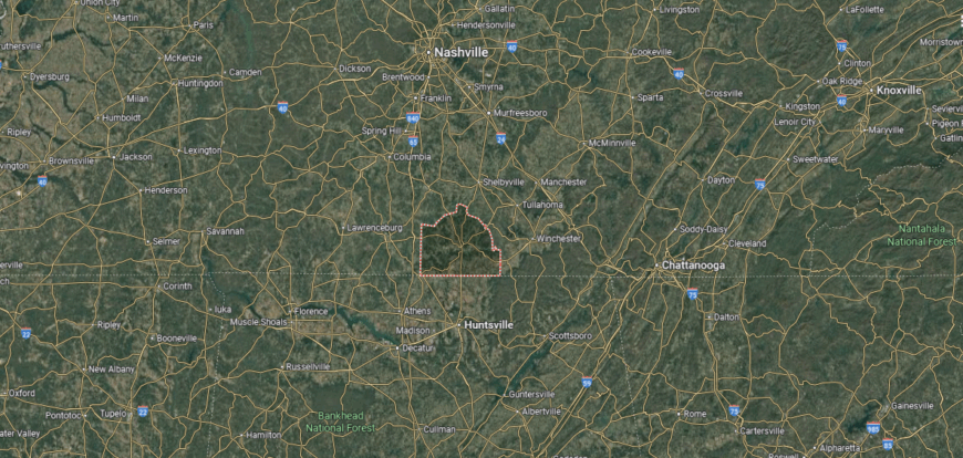
#46. Cheatham County (tie)
– Life expectancy: 72.8 years
— 1.3 years lower than the state average
Would you like to save this?
About
Cheatham County stretches along the Cumberland River, where wooded ridges and waterways shape both its scenery and way of life. The county has grown around a blend of rural settlements and towns that reflect a close relationship with nature and the river’s steady influence. Its identity is tied to outdoor spaces, quiet neighborhoods, and traditions passed down within tight-knit communities.
Local life includes music gatherings, river recreation, and festivals that highlight the county’s creative spirit. Residents value the balance between small-town living and proximity to Nashville, allowing both local roots and regional connections to thrive. Cheatham County embodies a lifestyle that is grounded in place yet open to growth and cultural exchange.
Where is Cheatham County?
Cheatham County is situated in Middle Tennessee, bordered by Montgomery County to the northwest, Davidson County to the east, and Dickson County to the west. It lies just 20 miles from downtown Nashville, offering both proximity to the city and access to the Cumberland River, which flows along its northern boundary. The county spans a mix of river valleys, wooded ridges, and fertile lowlands.
Ashland City, the county seat, rests along the Cumberland River and anchors the area’s civic and commercial life. Other communities include Pleasant View in the northern section and Kingston Springs near the southern edge along I-40. With its blend of small towns, river access, and closeness to Nashville, Cheatham County serves as both a quiet retreat and a commuter’s link to the metropolitan area.
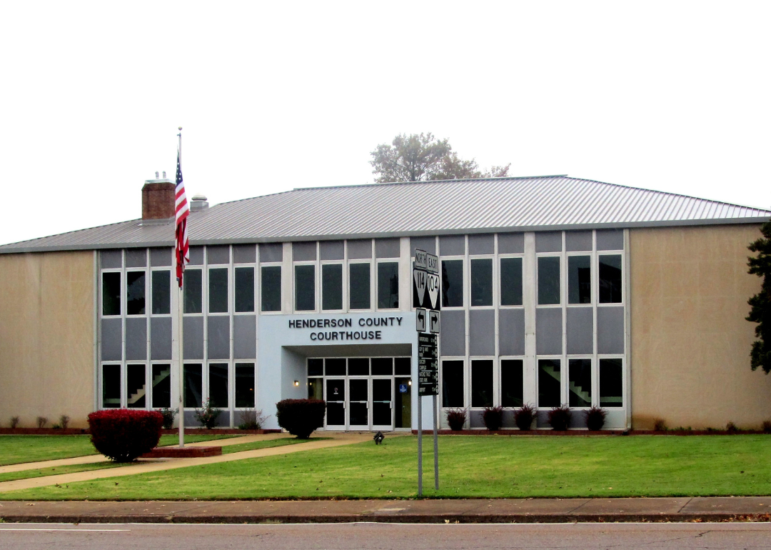
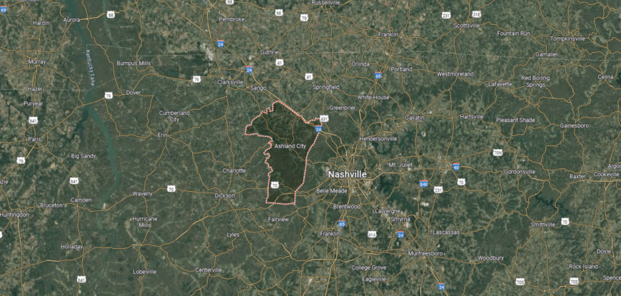
#45. Henderson County (tie)
– Life expectancy: 72.8 years
— 1.3 years lower than the state average
About
Henderson County is defined by its open farmland, small towns, and the steady presence of community traditions. The county’s history is closely tied to agriculture, but it has also grown around schools, churches, and local businesses that sustain daily life. Lakes and woodlands add a natural dimension, shaping both recreation and a sense of place.
Residents gather through fairs, sports, and neighborhood events that keep civic life active and connected. The pace is steady, with people valuing heritage while adapting to new opportunities in commerce and industry. Henderson County reflects a mix of rooted rural identity and the resilience of a community looking toward the future.
Where is Henderson County?
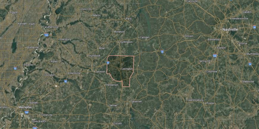
Henderson County is located in west-central Tennessee, bordered by Carroll County to the north, Decatur County to the south, and Madison County to the west. It sits about 100 miles northeast of Memphis and 125 miles southwest of Nashville, placing it between the state’s two largest cities. The county landscape features gentle hills, farmland, and waterways tied to the Tennessee River system.
Lexington, the county seat, lies near the center and functions as the primary hub for commerce and government. Smaller towns such as Scotts Hill and Sardis are found in the southern part, adding to the county’s rural setting. With Beech Lake and Natchez Trace State Park nearby, Henderson County blends community life with outdoor recreation opportunities.
#44. Obion County (tie)
– Life expectancy: 72.8 years
— 1.3 years lower than the state average
You may also like: Metros in Tennessee that are best for nurses
About
Obion County rises out of Tennessee’s northwest corner, where fertile fields meet the flow of the Mississippi River. Its history is marked by farming traditions, rail lines, and river trade that once connected local towns to wider markets. Today, that mix of agriculture and heritage still shapes the county’s sense of identity.
Life here often centers on county fairs, gatherings in town squares, and the rhythms of planting and harvest. Families pass down stories that link generations to the land, while industry and commerce provide steady growth. Obion County stands as a place where history and daily life remain closely woven together.
Where is Obion County?
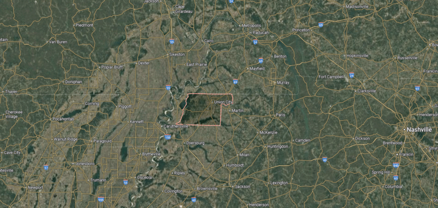
Obion County sits in the northwestern corner of Tennessee, bordered by Kentucky to the north and the Mississippi River to the west. Neighboring Tennessee counties include Lake County to the west and Weakley County to the east. The county lies about 120 miles northeast of Memphis and 175 miles northwest of Nashville, forming part of the state’s Reelfoot Lake region.
Union City, the county seat, is located near the center and serves as the economic hub. Smaller towns such as Troy, Hornbeak, and South Fulton contribute to the county’s community network. Known for its fertile farmland and proximity to Reelfoot Lake, Obion County combines agricultural strength with unique natural landscapes.
#43. Crockett County (tie)
– Life expectancy: 72.7 years
— 1.4 years lower than the state average

About
Crockett County carries the imprint of West Tennessee farmland, where rows of crops and quiet towns outline the landscape. Its communities are shaped by a heritage of hard work and resilience, with local schools and churches serving as anchors of daily life. The county’s name honors frontiersman Davy Crockett, a reminder of its deep historical roots.
People here gather for festivals, school events, and local traditions that keep the civic spirit alive. Agriculture remains a steady foundation, while small businesses and regional connections add new dimensions to the local economy. Crockett County reflects a balance of proud history and the enduring strength of rural community life.
Where is Crockett County?
Crockett County is in western Tennessee, bordered by Gibson County to the north, Madison County to the east, and Lauderdale County to the west. It sits about 30 miles northwest of Jackson and roughly 65 miles northeast of Memphis. The county covers a stretch of fertile farmland within the state’s agricultural heartland.
Alamo, the county seat, is centrally located and serves as the county’s administrative and cultural hub. Surrounding towns include Bells to the east along U.S. Highway 412 and Friendship to the west near the Lauderdale County line. With its network of small communities and rural landscapes, Crockett County maintains a close connection to west Tennessee’s farming traditions.
#42. Lawrence County (tie)
– Life expectancy: 72.7 years
— 1.4 years lower than the state average

About
Lawrence County rests along the rolling hills of southern Middle Tennessee, where farmland and forests shape its setting. The county’s history includes strong agricultural roots, manufacturing growth, and the legacy of leaders who left their mark on the region. Its towns reflect both tradition and progress, offering a blend of rural character and civic pride.
Residents gather at festivals, ball games, and community events that strengthen local ties. Outdoor recreation in parks and natural areas connects people to the landscape, while industries provide a foundation for modern opportunity. Lawrence County embodies a spirit that values hard work, heritage, and a shared vision for the future.
Where is Lawrence County?

Lawrence County lies along Tennessee’s southern border with Alabama, bordered by Lewis County to the north and Wayne County to the west. It is about 80 miles southwest of Nashville and 45 miles northeast of Florence, Alabama. The county stretches across rolling hills and farmland, with Shoal Creek and other waterways shaping its landscape.
Lawrenceburg, the county seat, sits near the center and is the largest city in the area. Smaller communities include Loretto near the Alabama line and Summertown in the northern section. With its location on the historic Natchez Trace Parkway, Lawrence County blends rural life with access to scenic travel routes and regional history.
#41. Clay County
– Life expectancy: 72.6 years
— 1.5 years lower than the state average

About
Clay County lies in the hills along the Cumberland River, where winding roads lead to small towns rooted in Tennessee’s highland traditions. Its past is tied to farming, timber, and river trade, all of which shaped the county’s character and the resilience of its people. The natural setting of valleys, ridges, and waterways gives it a distinct sense of place.
Life in Clay County is centered on school events, courthouse gatherings, and seasonal festivals that carry forward community pride. Residents value their closeness to the land, finding both work and leisure in its fields, forests, and lakes. Clay County remains a place where heritage, landscape, and community spirit flow together in everyday life.
Where is Clay County?
Clay County is in north-central Tennessee, bordered by Kentucky to the north and Jackson County to the south. It is roughly 100 miles northeast of Nashville and about 30 miles northwest of Cookeville. The county’s landscape is marked by ridges, valleys, and the Cumberland River system, which feeds into Dale Hollow Lake along the northern boundary.
Celina, the county seat, is located where the Obey River meets the Cumberland River. Small communities such as Moss and Hermitage Springs add to its rural character. With Dale Hollow Lake as a centerpiece, Clay County offers both a quiet agricultural setting and access to outdoor recreation along the Tennessee-Kentucky line.
#40. Shelby County
– Life expectancy: 72.5 years
— 1.6 years lower than the state average
About
Shelby County stands as Tennessee’s most populous county, with Memphis at its heart shaping much of its identity. The county’s character is built on a foundation of music, commerce, and civic history, from the Mississippi River’s trade routes to the cultural rhythms that gave rise to blues and soul. Alongside its urban energy, Shelby also holds farmland, parks, and river landscapes that balance the pace of daily life.
Community life thrives through festivals, concerts, and gatherings that celebrate both heritage and innovation. Residents engage with a mix of local traditions and global connections, reflecting the county’s role as both a regional anchor and cultural crossroads. Shelby County embodies a dynamic blend of history, creativity, and community strength that continues to define it.
Where is Shelby County?
Would you like to save this?
Shelby County is located at the far southwestern corner of Tennessee, bordered by the Mississippi River to the west and the state of Mississippi to the south. It is the most populous county in the state, positioned about 200 miles southwest of Nashville and covering part of the Mississippi Delta region. The county spans flat bottomlands and river bluffs, shaped heavily by the presence of the Mississippi River.
Memphis, the county seat, is also the largest city in Tennessee and serves as a major cultural and economic hub. Surrounding communities include Bartlett to the northeast, Germantown to the east, and Collierville near the Mississippi line. Shelby County’s location along the Mississippi River makes it a key center for transportation, commerce, and cultural exchange in the Mid-South.
#39. Overton County (tie)
– Life expectancy: 72.4 years
— 1.7 years lower than the state average
You may also like: Movies and TV shows casting in Tennessee
About
Overton County rests in the Upper Cumberland region, where rolling hills and forested ridges create a strong sense of place. Its history is shaped by farming communities, early frontier settlements, and the steady growth of small towns that hold to long-standing traditions. The county’s natural setting offers both beauty and practicality, tying residents closely to the land.
Life here unfolds around school events, courthouse squares, and outdoor recreation in the surrounding lakes and parks. Families pass down a heritage of resilience, with each generation adding to the county’s story while keeping its roots intact. Overton County reflects a blend of landscape, history, and community ties that remain deeply connected.
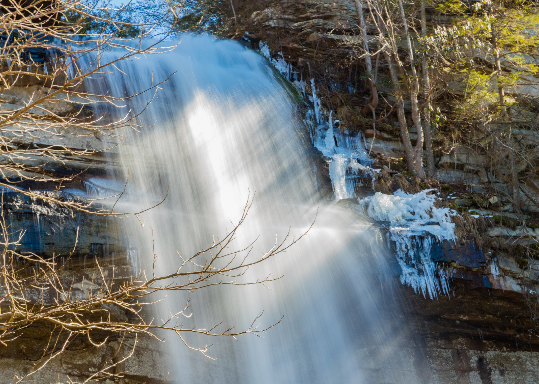
Where is Overton County?
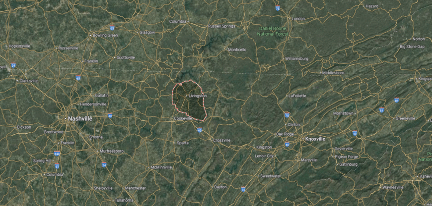
Overton County is set in north-central Tennessee, bordered by Clay County to the northwest, Fentress County to the northeast, and Putnam County to the south. It lies about 100 miles east of Nashville and 20 miles north of Cookeville. The terrain includes portions of the Cumberland Plateau, giving the county a mix of ridges, valleys, and forested hills.
Livingston, the county seat, is positioned near the center and serves as the focal point for business and government. Smaller communities include Allons to the north and Alpine near the eastern border. With Standing Stone State Park and Dale Hollow Lake nearby, Overton County connects rural living with access to outdoor recreation.
#38. Rhea County (tie)
– Life expectancy: 72.4 years
— 1.7 years lower than the state average

About
Rhea County stretches along the Tennessee River, where valleys and ridges frame towns with deep historical significance. Known for the Scopes Trial of 1925, the county holds a unique place in American legal and cultural memory while maintaining its agricultural and industrial roots. Its landscape and history together shape a strong sense of identity.
Local gatherings, from courthouse events to riverfront festivals, bring residents together in shared tradition. Families value the balance of work, school, and recreation, with outdoor life on the river and surrounding hills as a steady backdrop. Rhea County continues to blend historic legacy with the enduring rhythm of community life.
Where is Rhea County?
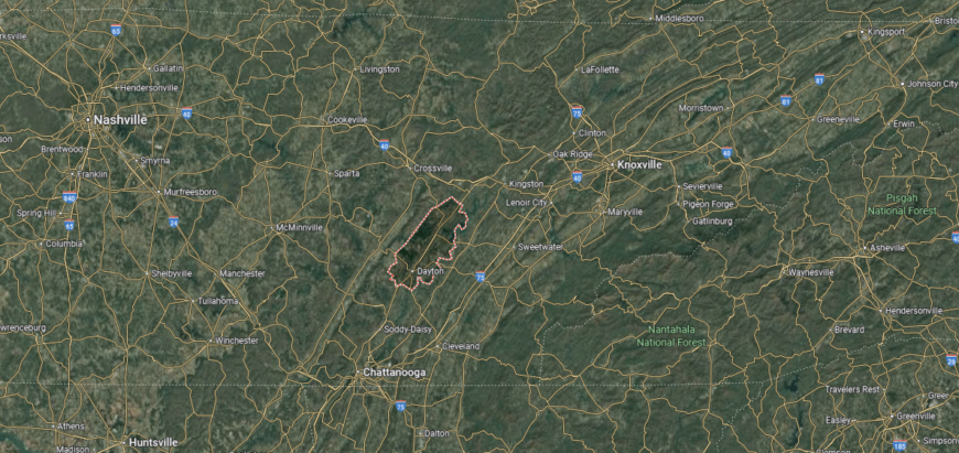
Rhea County is in eastern Tennessee, bordered by Roane County to the north, Hamilton County to the south, and Bledsoe County to the west. It lies along the Tennessee River, about 50 miles north of Chattanooga and 65 miles southwest of Knoxville. The county stretches from the river valley eastward into the ridges of the Cumberland Plateau.
Dayton, the county seat, sits near the river and is historically known for the 1925 Scopes Trial. Other towns include Spring City in the northern section along Watts Bar Lake and Graysville near the Hamilton County line. With its blend of riverfront communities and plateau highlands, Rhea County links history, industry, and natural landscapes.
#37. Greene County (tie)
– Life expectancy: 72.4 years
— 1.7 years lower than the state average
About
Greene County holds a prominent place in Tennessee’s history, known as the home of President Andrew Johnson and as one of the state’s earliest centers of settlement. Its identity is shaped by a blend of agricultural strength, manufacturing growth, and civic traditions that have endured for generations. The county’s hills, valleys, and town squares provide both a scenic and practical foundation for community life.
Cultural life is enriched by historic sites, educational institutions, and gatherings that celebrate both heritage and progress. Residents maintain a rhythm that values family ties, local pride, and the lessons of history as guides for the future. Greene County stands as a community where past and present remain closely woven together in daily living.
Where is Greene County?
Greene County is located in northeastern Tennessee, bordered by Washington County to the north, Cocke County to the south, and Hawkins County to the west. It sits about 70 miles northeast of Knoxville and 35 miles southwest of the Virginia state line. The county’s landscape ranges from fertile valleys to the foothills of the Appalachian Mountains, with the Nolichucky River cutting through its center.
Greeneville, the county seat, is the oldest town in Tennessee and serves as both a historic and civic hub. Smaller communities such as Tusculum, Baileyton, and Mosheim add to the county’s network of towns. With its mix of agricultural land, mountain scenery, and historic significance, Greene County anchors the region’s cultural and natural heritage.
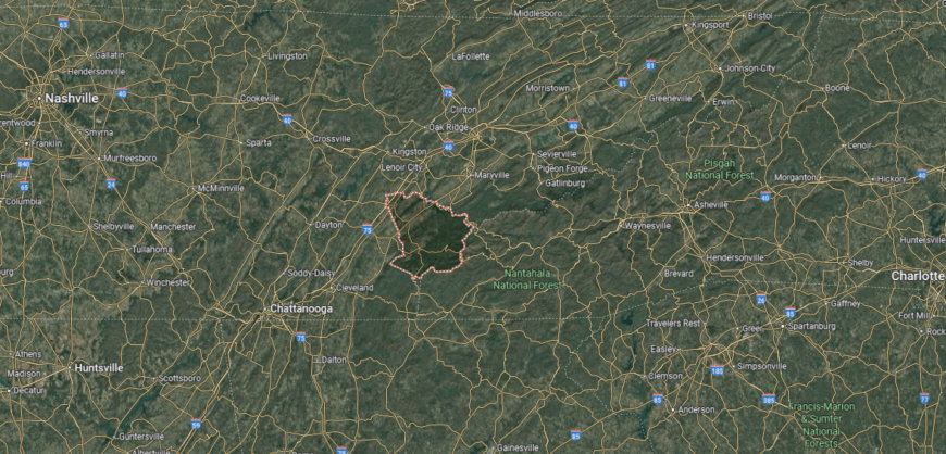
#36. McMinn County (tie)
– Life expectancy: 72.2 years
— 1.9 years lower than the state average
About
McMinn County rests in East Tennessee’s foothills, where farmland and ridges shape a setting long tied to agriculture and local trade. Its towns grew from early settlement roots into communities that balance tradition with steady economic development. The county’s location along key travel routes has also given it a role as a connector within the region.
Life here revolves around school activities, courthouse squares, and festivals that highlight both local pride and regional ties. Outdoor recreation in rivers, trails, and nearby mountains offers residents a daily link to the landscape. McMinn County reflects a blend of small-town strength, natural beauty, and enduring community connections.
Where is McMinn County?
McMinn County is situated in southeastern Tennessee, bordered by Roane County to the north, Monroe County to the east, and Bradley County to the south. It lies about halfway between Knoxville and Chattanooga, roughly 55 miles from each city, with Interstate 75 running through its center. The landscape features rolling hills, farmland, and access to the Hiwassee and Tennessee Rivers.
Athens, the county seat, is centrally located and serves as the commercial and governmental center. Other towns include Etowah to the east and Niota to the north, noted as the smallest incorporated city in the state. With its position along major highways and proximity to two larger cities, McMinn County blends small-town life with regional connectivity.
#35. Henry County (tie)
– Life expectancy: 72.2 years
— 1.9 years lower than the state average
About
Henry County sits in northwest Tennessee, anchored by the city of Paris and its historic courthouse square. Its identity is shaped by farmland, commerce, and the steady influence of Kentucky Lake, which provides both recreation and economic opportunity. The county blends rural tradition with a role as a regional hub.
Residents come together through festivals, lakefront gatherings, and school events that reinforce community spirit. The rhythm of daily life balances work on the land with leisure on the water. Henry County reflects a place where history, landscape, and community ties continue to move in step.
Where is Henry County?
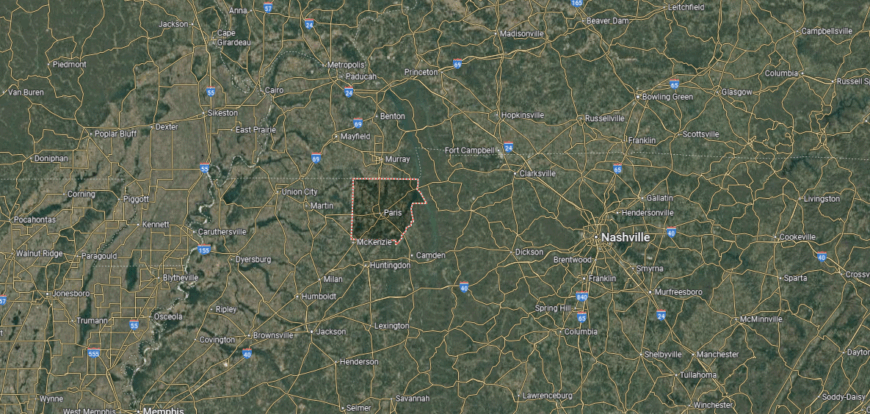
Henry County is in northwestern Tennessee, bordered by Kentucky to the north and the Tennessee River to the east. It lies about 60 miles northeast of Jackson and 120 miles northwest of Nashville. The county is characterized by fertile farmland, rolling hills, and access to Kentucky Lake, a major reservoir on the Tennessee River.
Paris, the county seat, sits near the center and is the largest city in the area. Smaller communities such as Cottage Grove, Henry, and Puryear contribute to the county’s rural framework. With Kentucky Lake and the Land Between the Lakes nearby, Henry County combines agricultural strength with recreational opportunities.
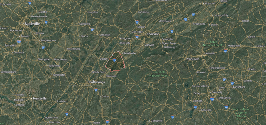
#34. Monroe County (tie)
– Life expectancy: 72.1 years
— 2.0 years lower than the state average
You may also like: Cities with the most expensive homes in Tennessee
About
Monroe County lies where the Appalachian Mountains meet the Tennessee Valley, giving it a landscape of ridges, rivers, and mountain passes. Its history is marked by Cherokee heritage, frontier settlement, and the enduring presence of rural communities. The setting provides both natural beauty and a sense of resilience that shapes daily life.
Community rhythms are tied to school events, mountain festivals, and outdoor traditions that celebrate the county’s setting. Residents value both the quiet of small towns and the opportunities that come with being close to natural gateways like the Cherohala Skyway. Monroe County remains a place where landscape, heritage, and community are inseparably linked.
Where is Monroe County?
Monroe County is located in southeastern Tennessee, bordered by Loudon County to the north, McMinn County to the west, and the state of North Carolina to the east across the Unicoi Mountains. It sits about 45 miles southwest of Knoxville and stretches from the Tennessee River valley into the higher elevations of the Cherokee National Forest. The terrain blends fertile lowlands with rugged mountain landscapes.
Madisonville, the county seat, is positioned near the center and anchors local government and commerce. Other towns include Sweetwater to the north, Vonore along the Little Tennessee River, and Tellico Plains at the gateway to the Cherohala Skyway. With its mix of valleys, rivers, and mountain access, Monroe County serves as both an agricultural hub and a scenic entry point into the Appalachians.
#33. Hawkins County (tie)
– Life expectancy: 72.1 years
— 2.0 years lower than the state average

About
Hawkins County stands among the state’s oldest counties, with Rogersville—Tennessee’s second-oldest town—at its center. Its roots stretch back to frontier settlement and early civic development, leaving behind courthouses, historic homes, and traditions that still anchor daily life. The Holston River and surrounding ridges add both scenery and continuity to its identity.
Residents gather through local fairs, heritage events, and school-centered activities that strengthen community pride. The county blends agricultural life with small-town commerce, offering a balance between history and present needs. Hawkins County reflects a place where the past remains visible in everyday rhythms, giving it a lasting sense of continuity.
Where is Hawkins County?
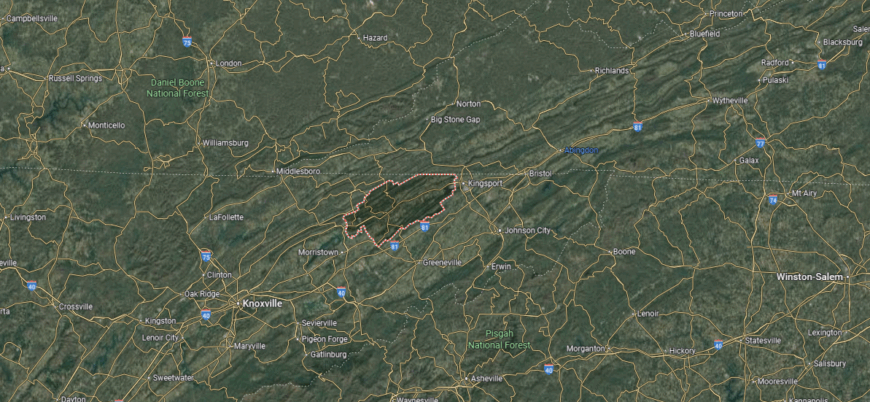
Hawkins County lies in northeastern Tennessee, bordered by Sullivan County to the northeast, Hancock County to the northwest, and Greene County to the south. It sits about 80 miles northeast of Knoxville and stretches along the Holston River, which winds through much of its length. The county covers a diverse landscape of river valleys, rolling hills, and forested ridges.
Rogersville, the county seat, is recognized as the second-oldest town in Tennessee and serves as the county’s historic and civic center. Other communities include Church Hill and Mount Carmel to the east, along with Bulls Gap on the southern edge. With its river corridors, agricultural lands, and deep historical roots, Hawkins County connects Appalachian culture with natural beauty.
#32. Giles County
– Life expectancy: 72.0 years
— 2.1 years lower than the state average
About
Giles County rests along Tennessee’s southern border, where rolling pastures and gentle hills stretch toward Alabama. Its story is tied to farming traditions, historic towns, and the courthouse square in Pulaski, which has long been the county’s civic and cultural heart. The landscape gives rhythm to daily life, with open fields and wooded ridges shaping both work and leisure.
Life here unfolds in a steady balance of heritage and progress—seasonal fairs, school gatherings, and community traditions carry forward old ties, while industry and education add new opportunities. Families remain closely connected to the land and to one another, preserving a sense of continuity across generations. Giles County endures as a place where history, landscape, and community weave together in lasting strength.
Where is Giles County?

Giles County is positioned along Tennessee’s southern border with Alabama, bordered by Maury County to the north and Lawrence County to the west. It lies about 70 miles south of Nashville and 40 miles north of Huntsville, Alabama, making it a crossroads between Middle Tennessee and northern Alabama. The landscape is marked by rolling farmland, wooded hills, and branches of the Elk River.
Pulaski, the county seat, sits near the center and serves as the main hub for government and commerce. Smaller towns such as Lynnville and Elkton add to the county’s rural character and community life. With its mix of agriculture, small-town culture, and proximity to major highways, Giles County provides a balance of tradition and connectivity.
#31. Hamblen County (tie)
– Life expectancy: 71.9 years
— 2.2 years lower than the state average
About
Hamblen County is anchored by Morristown, a regional hub for commerce, education, and manufacturing in East Tennessee. Its history reflects both agricultural beginnings and steady industrial growth, giving the county a dual identity rooted in tradition and progress. The surrounding ridges and Cherokee Lake frame its communities with a strong natural presence.
Local life includes school athletics, civic festivals, and downtown gatherings that keep residents connected. The county values its role as both a small-town community and a regional center for opportunity. Hamblen County represents a balance of work, heritage, and community pride that continues to shape its character.
Where is Hamblen County?
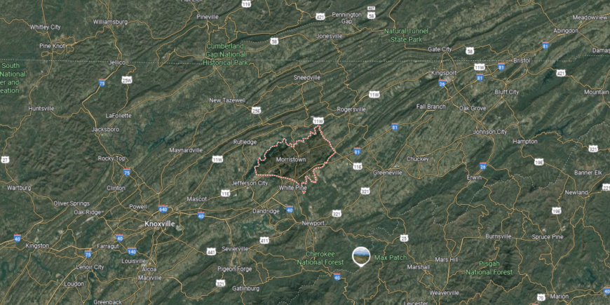
Hamblen County is located in northeastern Tennessee, bordered by Hawkins County to the north, Jefferson County to the south, and Grainger County to the west. It lies about 40 miles northeast of Knoxville and is part of the Tennessee Valley, with the Holston River and Cherokee Lake shaping much of its landscape. The terrain includes fertile valleys, rolling ridges, and water resources that define the area’s geography.
Morristown, the county seat, sits at the center and serves as the economic and cultural hub. Smaller communities such as Russellville and Whitesburg contribute to the county’s rural network. With Cherokee Lake as a key feature, Hamblen County blends outdoor recreation with its role as a growing regional center in East Tennessee.
#30. Claiborne County (tie)
– Life expectancy: 71.9 years
— 2.2 years lower than the state average
About
Claiborne County lies in the northern Appalachian foothills, where the Cumberland Gap once served as a passage for pioneers moving west. Its towns and rural communities carry deep ties to both frontier history and the steady traditions of farming and craftsmanship. The surrounding ridges and valleys continue to shape the county’s sense of place and identity.
Residents gather through heritage festivals, school events, and outdoor life rooted in the mountains and rivers. Families value the stories passed down across generations, keeping history alive while adapting to modern opportunities. Claiborne County reflects a community where landscape and legacy remain closely connected in daily life.
Where is Claiborne County?
Claiborne County is in northeastern Tennessee, bordered by Kentucky to the north and Virginia to the east. It lies about 60 miles north of Knoxville and encompasses part of the Powell River Valley along with the ridges of the Cumberland Mountains. The terrain ranges from fertile farmland in the valleys to rugged, forested highlands near the state lines.
Tazewell, the county seat, is located near the center and serves as a focal point for local government and commerce. New Tazewell, a neighboring community, forms a twin-town area with additional services and businesses. With Cumberland Gap National Historical Park nearby, Claiborne County links Appalachian history with natural mountain scenery.
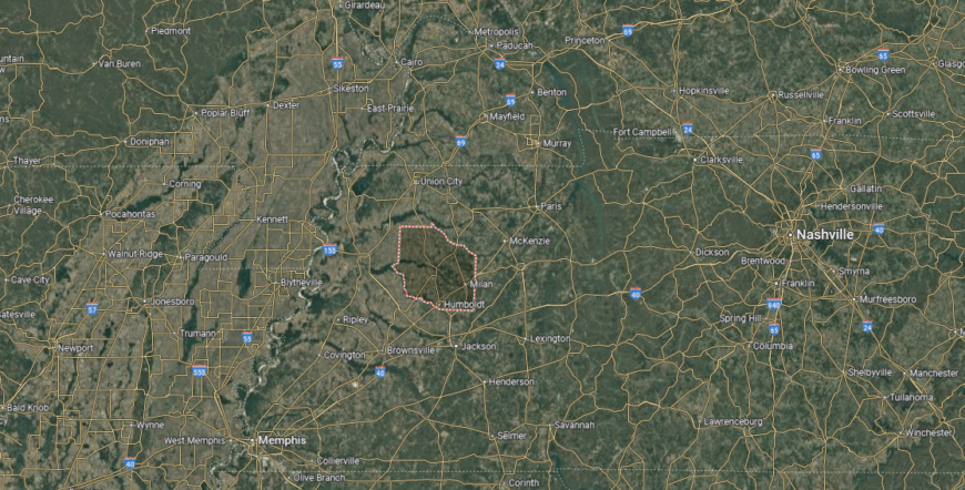
#29. Hardeman County (tie)
– Life expectancy: 71.9 years
— 2.2 years lower than the state average
You may also like: How drunk driving fatalities in Tennessee compare to the rest of the US
About
Hardeman County sits in West Tennessee, known for its farmland, small towns, and deep musical and cultural ties. Bolivar, the county seat, serves as a center of government and commerce while also preserving historic architecture and civic traditions. The county’s identity blends agriculture, heritage, and a growing role in regional development.
Community life is marked by festivals, school gatherings, and local events that keep residents connected. Outdoor spaces, from parks to open countryside, offer a steady link to the land. Hardeman County stands as a place where tradition and opportunity continue to move side by side.
Where is Hardeman County?
Hardeman County is located in southwestern Tennessee, bordered by Fayette County to the west, Madison County to the north, and the state of Mississippi to the south. It sits about 60 miles east of Memphis and 45 miles southwest of Jackson. The county’s landscape is characterized by rolling farmland, pine forests, and waterways that flow into the Hatchie River.
Bolivar, the county seat, is near the center and serves as the cultural and commercial hub. Smaller towns such as Middleton to the south and Whiteville to the north add to the county’s network of communities. With its blend of agriculture, historic sites, and natural areas, Hardeman County reflects both rural traditions and regional connections.
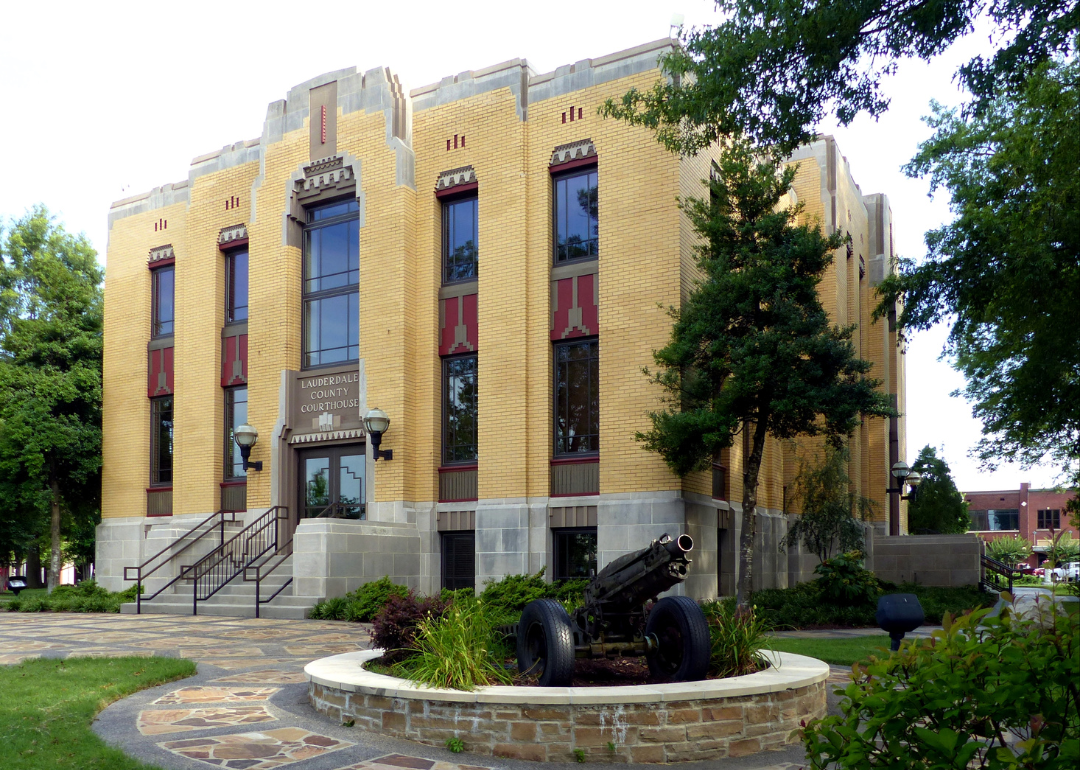
#28. Lauderdale County (tie)
– Life expectancy: 71.9 years
— 2.2 years lower than the state average
About
Lauderdale County stretches along the Mississippi River in West Tennessee, where fertile bottomlands have long shaped its agricultural identity. The county’s towns reflect both farming traditions and the influence of river trade that once carried goods and culture through the region. Rolling fields and river bluffs give the area a distinctive setting that ties community life to the land.
Residents gather through seasonal fairs, church events, and school-centered activities that reinforce shared values. Agriculture remains the county’s foundation, while new industries and local enterprises support steady growth. Lauderdale County embodies a life rooted in the rhythms of the river and the resilience of its people.
Where is Lauderdale County?
Lauderdale County is in western Tennessee, bordered by the Mississippi River to the west, Dyer County to the north, and Tipton County to the south. It lies about 60 miles north of Memphis and 45 miles west of Jackson. The county’s terrain includes river bottomlands, fertile plains, and bluffs overlooking the Mississippi.
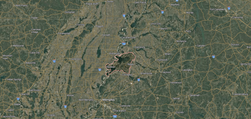
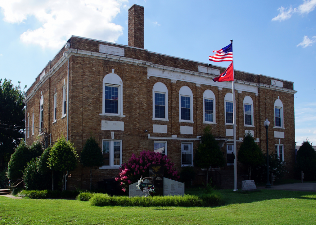
Ripley, the county seat, is centrally located and serves as the main center of commerce and government. Smaller towns include Halls in the northern part and Henning to the south near the river bluffs. With its agricultural base and direct access to the Mississippi River, Lauderdale County plays a key role in west Tennessee’s farming and trade.
#27. Scott County (tie)
– Life expectancy: 71.8 years
— 2.3 years lower than the state average
About
Scott County rests on the northern Cumberland Plateau, where rugged terrain and dense forests have shaped both settlement and spirit. Its history is distinct—during the Civil War, the county declared itself the “Free and Independent State of Scott,” a legacy that still symbolizes its resilience and independence. Timber, farming, and later outdoor tourism have all played a role in its development.
Community life is tied to mountain festivals, courthouse gatherings, and outdoor traditions that celebrate the county’s landscape. Residents take pride in generational roots, with family and heritage anchoring daily rhythms. Scott County remains a place where independence, history, and natural beauty continue to guide its identity.
Where is Scott County?
Scott County is located in northeastern Tennessee, bordered by McCreary County, Kentucky, to the north and Anderson County to the south. It sits about 55 miles northwest of Knoxville and lies within the Cumberland Plateau region. The county is noted for its rugged terrain, forested ridges, and deep river gorges shaped by the Big South Fork of the Cumberland River.
Huntsville, the county seat, is positioned near the center and serves as the administrative hub. Other communities include Oneida to the north and Winfield near the Kentucky border. With much of its land covered by the Big South Fork National River and Recreation Area, Scott County is defined by its natural beauty and outdoor recreation opportunities.
#26. Hickman County (tie)
– Life expectancy: 71.8 years
— 2.3 years lower than the state average
About
Hickman County lies in Middle Tennessee, where wooded ridges, winding creeks, and open farmland define its landscape. Its communities grew around timber, agriculture, and small-town trade, shaping a county identity that remains tied to the land. Natural beauty and quiet rural character give Hickman a distinct sense of place.
Residents come together at local fairs, school events, and gatherings that highlight both heritage and community pride. Outdoor life—whether fishing, hiking, or enjoying the countryside—remains central to daily rhythms. Hickman County reflects a balance of tradition, landscape, and enduring rural strength.
Where is Hickman County?
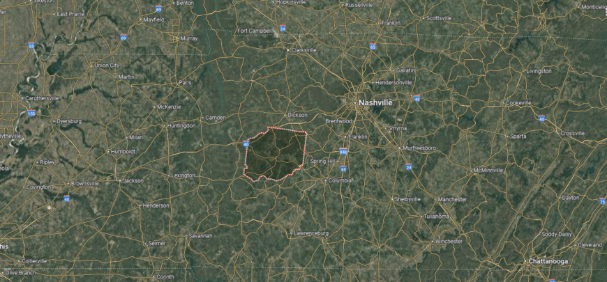
Hickman County is set in Middle Tennessee, bordered by Dickson County to the north, Lewis County to the south, and Williamson County to the east. It lies about 50 miles southwest of Nashville and covers a broad stretch of rolling hills, forests, and farmland typical of the Highland Rim. The Duck River flows through the county, providing a central natural feature.
Centerville, the county seat, is located near the center and serves as the main hub of civic and cultural life. Smaller communities include Bon Aqua in the northeast and Pleasantville in the southern part. With its blend of river valleys, wooded landscapes, and small towns, Hickman County reflects the rural character of central Tennessee.
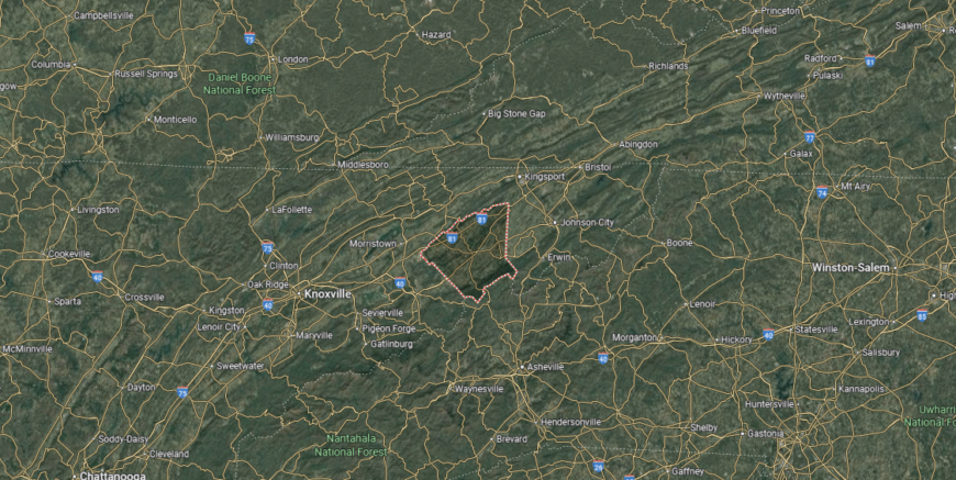
#25. Unicoi County (tie)
– Life expectancy: 71.8 years
— 2.3 years lower than the state average

About
Unicoi County rests in the Blue Ridge Mountains, where mountain ridges and valleys create a dramatic backdrop for daily life. Known historically for railroads and industry, the county has more recently embraced its role as a center for traditional crafts, music, and Appalachian culture. Its communities preserve heritage while drawing strength from both natural beauty and artistic expression.
Festivals, craft fairs, and cultural events connect residents through shared creativity and history. Outdoor recreation in the Cherokee National Forest ties people closely to the land while supporting tourism and community pride. Unicoi County represents a place where art, heritage, and mountain life remain deeply intertwined.
Where is Unicoi County?
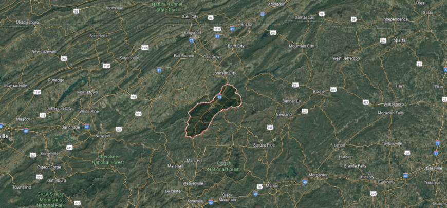
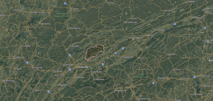
Unicoi County is in northeastern Tennessee, bordered by Washington County to the north, Carter County to the east, and the state of North Carolina along its southern boundary. It lies about 15 miles south of Johnson City and sits within the Unaka Mountains, part of the Appalachian range. The terrain is dominated by rugged peaks, forested slopes, and mountain streams.
Erwin, the county seat, is positioned in the Nolichucky River Valley and serves as the center of commerce and government. Other communities include Unicoi to the north and Flag Pond near the North Carolina line. With large portions of Cherokee National Forest within its borders, Unicoi County is defined by its mountain scenery and outdoor recreation opportunities.
#24. Carroll County (tie)
– Life expectancy: 71.8 years
— 2.3 years lower than the state average
You may also like: Counties with the worst droughts in Tennessee
About
Carroll County sits in northwest Tennessee, where farmland, small towns, and a network of schools and civic institutions shape its character. The county has long been tied to agriculture, while also building a reputation as a regional center for education and public life. Its location and traditions give it both stability and a steady role in the region.
Community life is defined by school athletics, county fairs, and courthouse gatherings that bring residents together. Families value strong local ties, balancing rural traditions with modern opportunities in commerce and industry. Carroll County reflects a steady rhythm of community pride and enduring civic spirit.
Where is Carroll County?
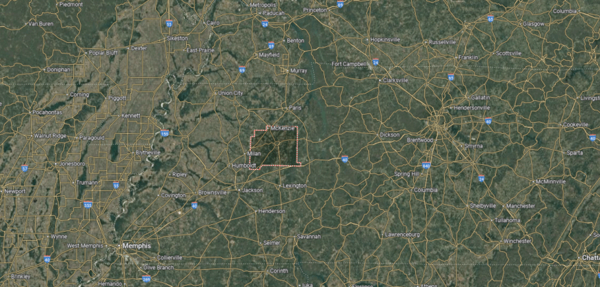
Carroll County is located in west Tennessee, bordered by Henry County to the north, Henderson County to the south, and Gibson County to the west. It sits about 120 miles northeast of Memphis and 125 miles west of Nashville, giving it a central position between the state’s two largest cities. The county’s landscape is composed of rolling farmland, timberlands, and a network of small creeks and rivers.
Huntingdon, the county seat, lies near the center and serves as the county’s main hub of activity. Other towns include McKenzie in the northwest and Bruceton along the southern border. With its rural communities and access to natural areas like the Carroll County Thousand Acre Recreational Lake, Carroll County combines agricultural life with outdoor resources.
#23. Lewis County (tie)
– Life expectancy: 71.7 years
— 2.4 years lower than the state average
About
Lewis County rests in the wooded hills of Middle Tennessee, where winding creeks and quiet ridges create a secluded landscape. Its communities grew from pioneer settlements into towns that keep close ties to the land and to traditions passed down across generations. The natural surroundings give the county a sense of calm resilience that defines daily life.
Residents gather at seasonal festivals, local schools, and town squares that preserve a spirit of togetherness. Outdoor life, from hunting and fishing to hiking in the ridges, keeps people tied to the environment around them. Lewis County stands as a place where nature and community remain closely intertwined.
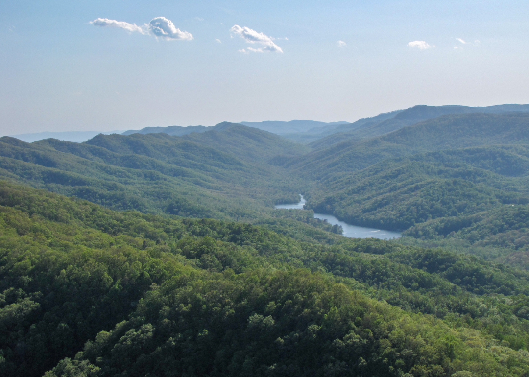
Where is Lewis County?
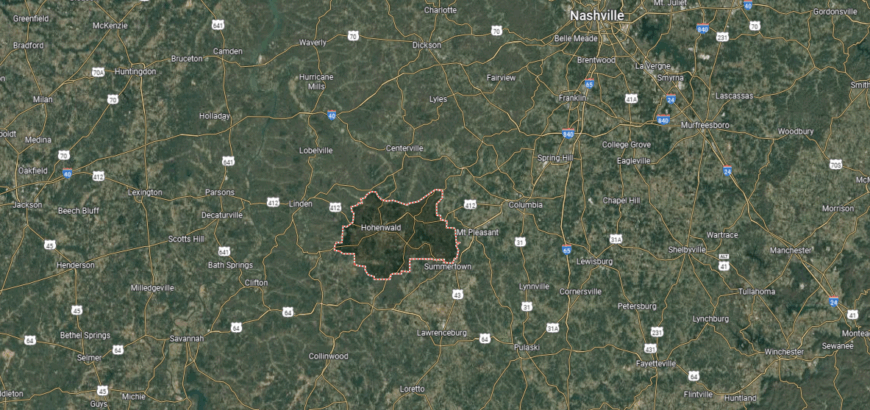
Lewis County is in Middle Tennessee, bordered by Hickman County to the north, Lawrence County to the south, and Maury County to the east. It lies about 70 miles southwest of Nashville and stretches across the wooded ridges and valleys of the Highland Rim. The Buffalo River runs through the county, adding to its natural features.
Hohenwald, the county seat, sits near the center and is the largest town in the county. Smaller communities include Gordonsburg to the northeast and Kimmins to the south. With its mix of forestland, farmland, and riverways, Lewis County reflects a balance of rural life and natural beauty.
#22. Grainger County (tie)
– Life expectancy: 71.7 years
— 2.4 years lower than the state average
About
Grainger County lies in East Tennessee, known for its ridges, valleys, and the waters of Cherokee Lake. Farming has long been central here, with tomatoes becoming the county’s most recognized crop and a source of local pride. Small towns and rural communities carry forward traditions that keep agriculture at the heart of daily life.
Community events include the annual tomato festival, school gatherings, and courthouse-centered activities that bring residents together. Families value their rural setting while benefiting from the county’s proximity to larger regional centers. Grainger County represents a blend of agricultural identity, scenic beauty, and strong local connection.
Where is Grainger County?
Grainger County is located in northeastern Tennessee, bordered by Union County to the west, Hawkins County to the northeast, and Jefferson County to the south. It lies about 35 miles northeast of Knoxville and is part of the Ridge-and-Valley region of the Appalachians. Cherokee Lake, formed by the Holston River, extends across much of the county, shaping both its geography and recreation.
Rutledge, the county seat, is positioned near the center and anchors government and community life. Other small towns include Bean Station to the north and Washburn in the western section. Known for its agricultural roots, especially tomato farming, Grainger County combines fertile valleys, mountain ridges, and lakefront areas.
#21. Polk County (tie)
– Life expectancy: 71.7 years
— 2.4 years lower than the state average
About
Polk County rests in the southeastern corner of Tennessee, where the Ocoee and Hiwassee Rivers carve their way through the Cherokee National Forest. Its history is tied to Cherokee heritage, early settlement, and the development of river-powered industry that once drove local growth. The county’s rugged terrain and waterways remain central to its identity today.
Life here often revolves around outdoor adventure—rafting on the Ocoee, hiking forest trails, and fishing mountain streams connect residents and visitors to the land. Community traditions are preserved through local festivals, school events, and gatherings that honor both heritage and natural beauty. Polk County reflects a place where history, landscape, and community spirit are inseparably linked.
Where is Polk County?
Polk County is in the southeastern corner of Tennessee, bordered by North Carolina to the east and Georgia to the south. It lies about 60 miles east of Chattanooga and sits within the southern Appalachian Mountains, where the Ocoee and Hiwassee Rivers flow through steep valleys. The terrain is dominated by the Cherokee National Forest, with rugged ridges and forested slopes.
Benton, the county seat, is located near the center along the Ocoee River valley. Other communities include Copperhill on the Georgia line and Ducktown near the North Carolina border, both tied to the county’s mining history. With its rivers, mountains, and forested lands, Polk County is known as a gateway for whitewater rafting, hiking, and mountain exploration.
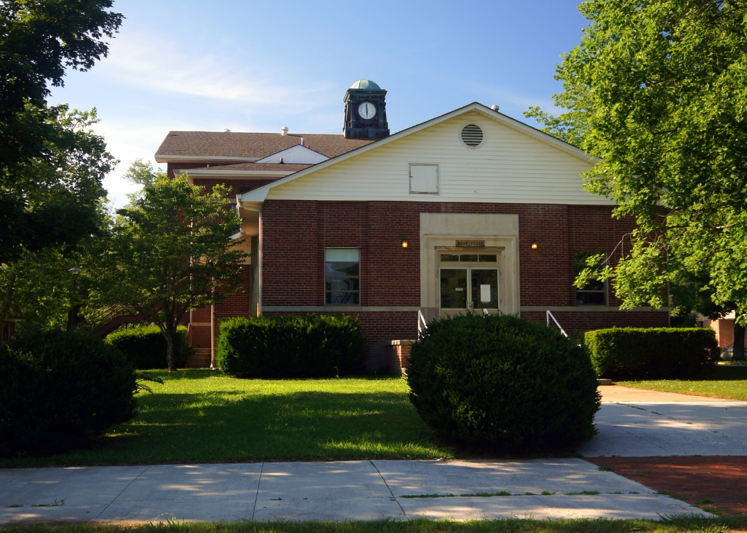
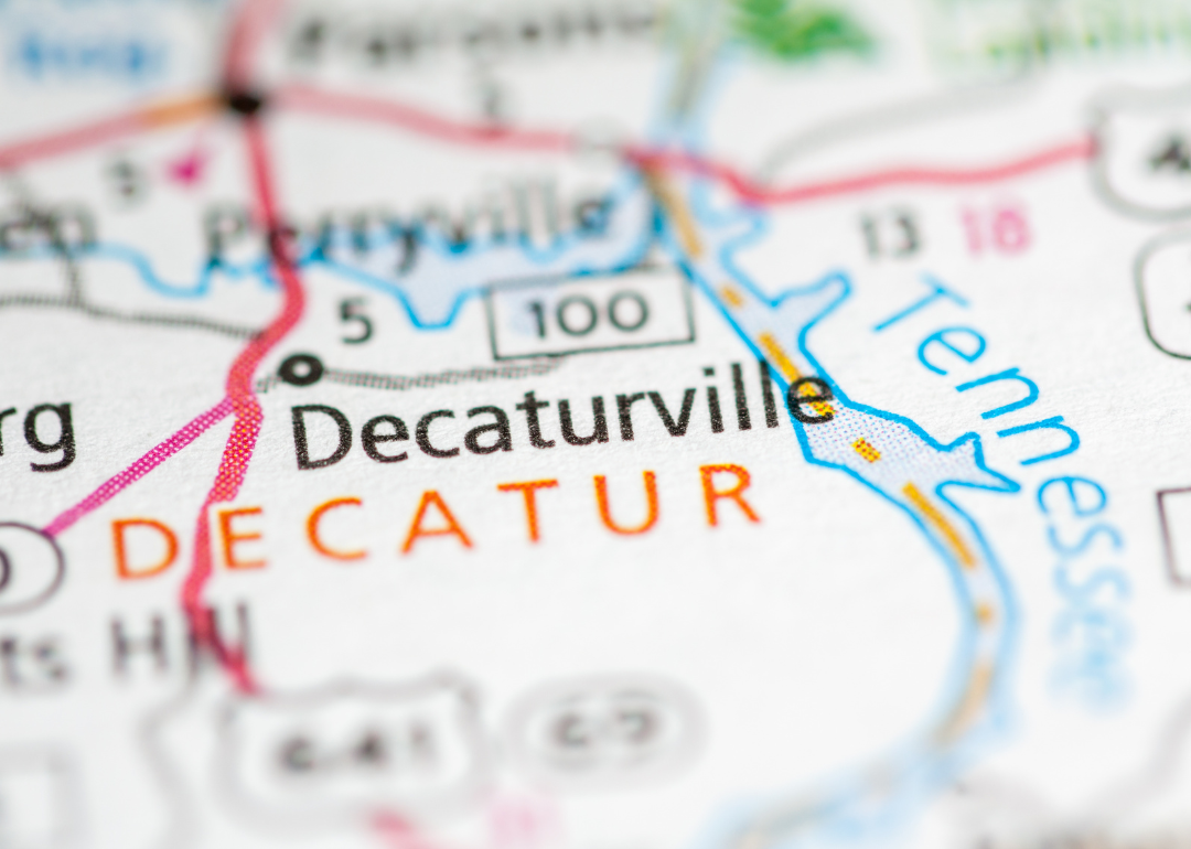
#20. Decatur County (tie)
– Life expectancy: 71.7 years
— 2.4 years lower than the state average

About
Decatur County sits along the Tennessee River in West Tennessee, where riverfront land and rural communities shape its identity. Agriculture has long been central, while the river supports both commerce and recreation. Parsons and Decaturville serve as the county’s main civic and cultural centers.
Residents gather through school activities, local fairs, and riverfront events that connect people to one another. Daily life balances farming traditions with the opportunities that come from the river’s steady influence. Decatur County reflects a community grounded in land, water, and enduring local pride.
Where is Decatur County?
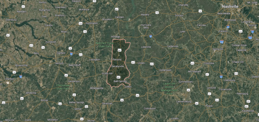
Decatur County is located in western Tennessee, bordered by Perry County to the north, Hardin County to the south, and the Tennessee River forming its eastern boundary. It lies about 100 miles southwest of Nashville and 60 miles northeast of Jackson. The county is shaped by rolling uplands, river bluffs, and fertile bottomlands along the Tennessee River.
Decaturville, the county seat, is near the center of the county and serves as its civic hub. Parsons, the largest town, sits to the north along Highway 412 and provides much of the county’s commerce. With its mix of rural communities and direct access to the Tennessee River, Decatur County balances small-town life with outdoor recreation.
#19. Cannon County (tie)
– Life expectancy: 71.6 years
— 2.5 years lower than the state average
You may also like: Counties with the highest rates of high blood pressure in Tennessee

About
Cannon County lies in Middle Tennessee, where rolling farmland and wooded ridges surround its small towns. The county is known for its long tradition of crafts, especially woodworking and pottery, which remain symbols of local heritage. Its rural setting gives it a sense of continuity, where history and landscape are closely connected.
Life here is shaped by craft fairs, music gatherings, and school-centered events that bring residents together. Families pass down skills and traditions, creating ties that stretch across generations. Cannon County reflects a place where artistry, community, and rural life remain firmly woven together.
Where is Cannon County?
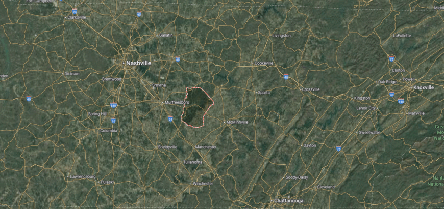
Cannon County is in Middle Tennessee, bordered by Wilson County to the north, Warren County to the southeast, and Rutherford County to the west. It lies about 50 miles southeast of Nashville and sits within the rolling hills of the Highland Rim. The landscape is marked by farmland, wooded ridges, and limestone valleys.
Woodbury, the county seat, is centrally located and serves as the hub for government and community life. Smaller communities include Auburntown in the northern section and Readyville near the Rutherford County line. With its agricultural base and scenic countryside, Cannon County reflects the rural traditions of central Tennessee.
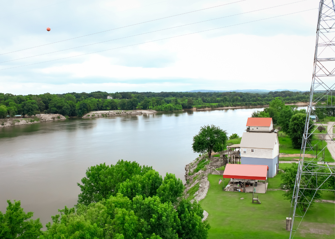
#18. Humphreys County (tie)
– Life expectancy: 71.6 years
— 2.5 years lower than the state average
About
Humphreys County sits in Middle Tennessee, with the Tennessee River shaping both its economy and recreation. Waverly, the county seat, serves as the center of civic life while also carrying the memory of historic challenges and recovery that have shaped the community’s strength. Farming, small industry, and river access all contribute to its identity.
Local gatherings—school events, county fairs, and church-centered traditions—keep residents closely connected. Families value the steady pace of small-town life while also drawing from the opportunities provided by the river and regional commerce. Humphreys County represents a community rooted in resilience, shared ties, and an enduring spirit of place.
Where is Humphreys County?
Humphreys County is positioned in Middle Tennessee, bordered by Benton County to the north, Hickman County to the south, and the Tennessee River to the west. It lies about 70 miles west of Nashville and 60 miles east of Jackson, giving it a central spot along Interstate 40. The county’s terrain includes river bottomlands, wooded hills, and stretches of farmland.
Waverly, the county seat, sits near the center and functions as the county’s primary hub. Smaller towns include New Johnsonville on the Tennessee River and McEwen in the eastern section. With its river access, rural communities, and transportation routes, Humphreys County connects Middle Tennessee to the broader western region of the state.
#17. Houston County
– Life expectancy: 71.5 years
— 2.6 years lower than the state average

About
Houston County rests in the western Highland Rim, where wooded hills and winding creeks create a quiet, secluded setting. Its history is tied to iron industry roots and the resilience of small communities that grew from those early settlements. The county’s landscape continues to shape daily life, giving it a strong connection to nature and tradition.
Residents gather at local festivals, school events, and church activities that reinforce community pride. Outdoor life—whether hunting, fishing, or exploring the hills—remains central to the county’s rhythm. Houston County reflects a place where history, land, and community spirit remain closely intertwined.
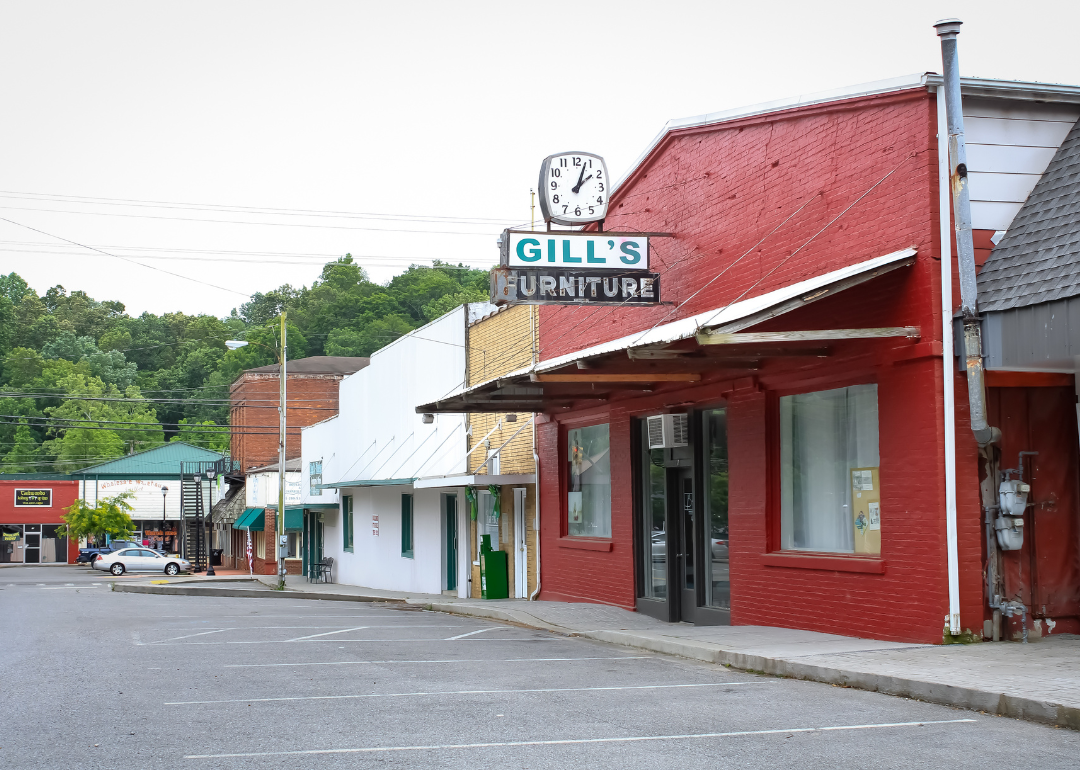
Where is Houston County?
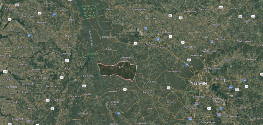
Houston County is located in northwestern Middle Tennessee, bordered by Stewart County to the north, Humphreys County to the south, and the Tennessee River to the east. It lies about 70 miles west of Nashville and covers part of the Cumberland River system’s valley lands. The terrain features forested ridges, fertile river bottoms, and rolling farmland.
Erin, the county seat, sits near the center and is known for its annual Irish celebration that highlights the town’s heritage. Smaller communities include Tennessee Ridge along the northern border and Arlington near the river. With its mix of cultural traditions, rural landscapes, and waterways, Houston County maintains a strong sense of local identity.
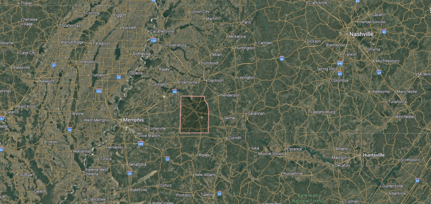
#16. McNairy County
– Life expectancy: 71.4 years
— 2.7 years lower than the state average
About
McNairy County sits in southwest Tennessee, known for its blend of farmland, small towns, and strong local traditions. Its history includes ties to music and law enforcement, remembered through figures like Sheriff Buford Pusser, whose legacy remains part of the county’s identity. Agriculture and small industry continue to support the region’s growth.
Residents connect through school athletics, courthouse events, and community gatherings that highlight local pride. The rhythm of life balances rural heritage with modern opportunities in commerce and culture. McNairy County reflects a community where history and daily life remain firmly linked.
Where is McNairy County?
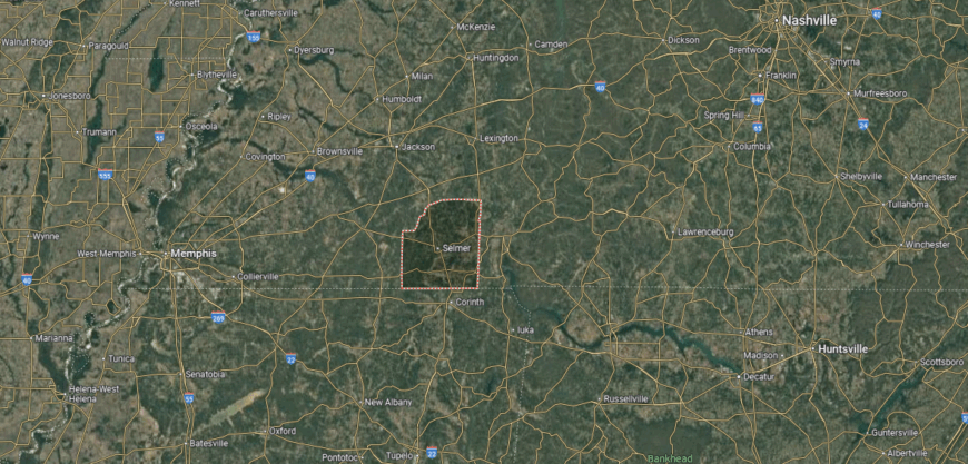
McNairy County is in southwestern Tennessee, bordered by Hardin County to the north, Hardeman County to the west, and the state of Mississippi to the south. It lies about 100 miles east of Memphis and 45 miles south of Jackson. The county landscape is made up of rolling farmland, timberland, and small creeks feeding into the Tennessee River system.
Selmer, the county seat, is centrally located and serves as the government and commercial hub. Other towns include Adamsville to the northeast, known for straddling the Hardin County line, and Guys near the Mississippi border. With its mix of rural communities and regional highways, McNairy County links west Tennessee with northern Mississippi.
#15. Benton County
– Life expectancy: 71.3 years
— 2.8 years lower than the state average

About
Benton County rests along the Tennessee River, where rolling hills meet wide waters that shape both landscape and life. Its history is tied to farming, river trade, and small-town traditions that have carried forward for generations. The setting of fields, bluffs, and shoreline gives the county a rhythm deeply connected to nature.
Residents gather through riverfront festivals, school events, and courthouse traditions that preserve local pride. Fishing, boating, and outdoor life remain central, linking people to the water that defines their home. Benton County stands as a place where land, river, and community flow together in lasting harmony.
Where is Benton County?
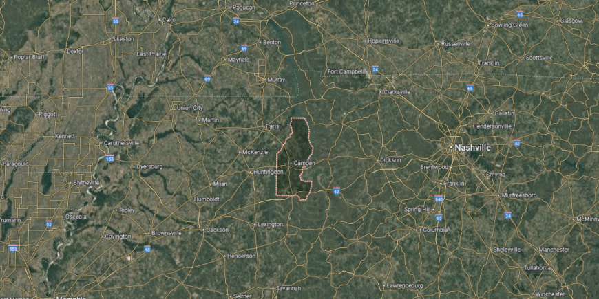
Benton County is located in western Tennessee, bordered by Henry County to the north, Decatur County to the south, and the Tennessee River forming much of its eastern boundary. It sits about 65 miles northeast of Jackson and 95 miles west of Nashville. The county’s landscape is defined by river valleys, wooded ridges, and fertile bottomlands tied to the Tennessee River.
Camden, the county seat, lies near the center and serves as the primary hub for government and commerce. Smaller communities include Big Sandy to the north along Kentucky Lake and Holladay in the southern section. With its access to both the Tennessee River and Kentucky Lake, Benton County combines rural life with opportunities for recreation and water-based industries.
#14. DeKalb County (tie)
– Life expectancy: 71.2 years
— 2.9 years lower than the state average
You may also like: Where people in Tennessee are moving to most
About
DeKalb County rises out of Tennessee’s hill country, where valleys and ridges frame a setting shaped by farming and early frontier life. Smithville, the county seat, reflects both history and culture, carrying forward traditions that link the community to its Appalachian roots. The presence of Center Hill Lake adds a newer dimension, connecting the county to recreation and tourism.
Residents celebrate heritage through music, craft, and the enduring rhythm of rural life. Generations have passed down both the land and the traditions that sustain it, giving the county a strong sense of continuity. DeKalb County remains a place where history, culture, and landscape flow together in everyday life.
Where is DeKalb County?
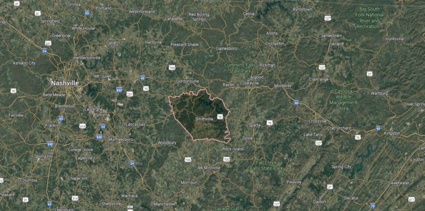
DeKalb County is located in Middle Tennessee, framed by Putnam County to the northeast, Warren County to the south, and Wilson County to the west. It sits roughly 60 miles east of Nashville and stretches across rolling farmland, wooded hills, and the valleys carved by the Caney Fork River. The presence of Center Hill Lake gives the county a defining natural landmark.
Smithville, the county seat, lies near the center and serves as the primary hub of local life. Smaller towns such as Dowelltown, Alexandria, and Liberty contribute to the county’s rural character. With its blend of agricultural land, scenic waterways, and small-town communities, DeKalb County connects Middle Tennessee’s countryside with natural recreation.
#13. Fentress County (tie)
– Life expectancy: 71.2 years
— 2.9 years lower than the state average
About
Fentress County rests on the Cumberland Plateau, a landscape of rolling uplands, forests, and open farmland that has shaped its identity. Its history includes frontier settlements, early agriculture, and a role as home to the World War I hero Sgt. Alvin C. York. The plateau’s rugged character continues to define the county’s sense of place.
Life here revolves around school events, historic commemorations, and outdoor traditions tied to the land. State parks and scenic areas connect residents to the plateau’s beauty while supporting tourism and recreation. Fentress County reflects a community where history, land, and resilience remain closely intertwined.
Where is Fentress County?
Fentress County is in north-central Tennessee, bordered by Pickett County to the north, Morgan County to the east, and Cumberland County to the south. It lies about 65 miles northwest of Knoxville and sits atop the Cumberland Plateau. The landscape is marked by flat-topped ridges, forested valleys, and waterways tied to the Big South Fork of the Cumberland River.
Jamestown, the county seat, is located near the center and serves as the hub for commerce and government. Smaller communities include Allardt to the south and Pall Mall to the north, the latter known as the home of World War I hero Alvin C. York. With its rugged terrain and proximity to Big South Fork National River and Recreation Area, Fentress County is closely tied to outdoor adventure and plateau culture.
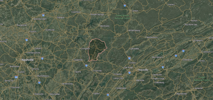
#12. Hancock County (tie)
– Life expectancy: 71.2 years
— 2.9 years lower than the state average

About
Hancock County sits in northeast Tennessee, bordered by ridges and valleys that keep its communities closely tied to the land. It is known as the historic home of the Melungeon people, giving the county a unique cultural identity within the region. Farming and small-town life remain central to its rhythm.
Residents gather through school events, festivals, and local traditions that keep community ties strong. Outdoor life in the ridges and river valleys shapes recreation and daily living. Hancock County reflects a place where cultural heritage and rural strength remain deeply connected.
Where is Hancock County?
Hancock County is located in northeastern Tennessee, bordered by Virginia to the north, Claiborne County to the west, and Hawkins County to the east. It lies about 60 miles northeast of Knoxville and is nestled within the Appalachian Ridge-and-Valley region. The terrain includes steep ridges, narrow valleys, and sections of the Clinch River.
Sneedville, the county seat, is positioned near the center and serves as the primary hub of government and community life. Smaller settlements are scattered through the mountain valleys, emphasizing the county’s rural character. With its rugged landscape and historic ties to the Melungeon community, Hancock County reflects a unique part of Tennessee’s cultural and geographic identity.
#11. Haywood County
– Life expectancy: 71.1 years
— 3.0 years lower than the state average
About
Haywood County lies in West Tennessee, where fertile Delta soils have long supported cotton farming and a strong agricultural identity. Its history is deeply tied to African American heritage, with music, culture, and civil rights shaping the county’s legacy. Brownsville, the county seat, reflects this history through its civic life and cultural landmarks.
Community spirit thrives in festivals, church events, and gatherings that celebrate both tradition and progress. Agriculture remains important, while industry and cultural tourism add new layers to the local economy. Haywood County stands as a place where heritage, resilience, and community pride continue to define its character.
Where is Haywood County?
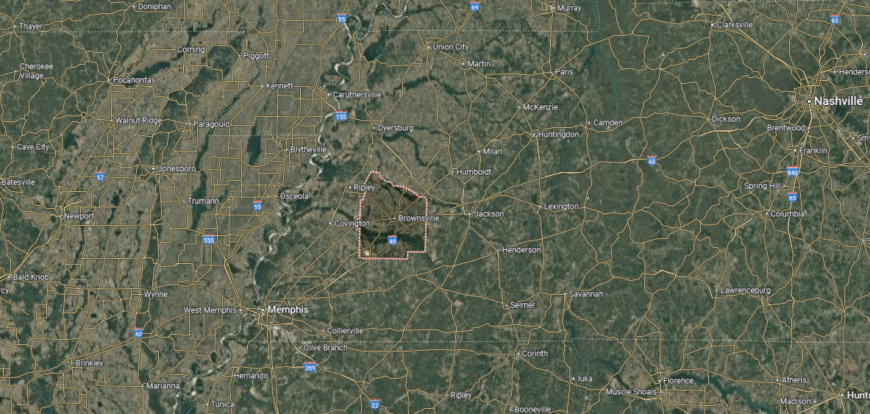
Haywood County is in western Tennessee, bordered by Crockett County to the north, Fayette County to the south, and Madison County to the east. It lies about 60 miles northeast of Memphis and 25 miles west of Jackson. The county is part of the fertile Mississippi Delta region, with flat farmland stretching across its landscape.
Brownsville, the county seat, is centrally located and serves as the county’s largest town and commercial hub. Smaller communities include Stanton in the southwest and Nutbush, known for its cultural heritage, to the north. With its rich agricultural base and location along key highways, Haywood County plays an important role in West Tennessee’s farming and trade.
#10. Union County
– Life expectancy: 71.0 years
— 3.1 years lower than the state average
About
Union County lies in the ridges and valleys of East Tennessee, where Norris Lake winds along its edge and shapes much of its character. The county’s roots are tied to farming communities and the formation of Norris Dam, which transformed both landscape and economy. Its hills, water, and rural towns together create a setting that feels both grounded and enduring.
Life here follows the rhythm of the land, from lake recreation to school gatherings and local festivals. Families value a slower pace, where heritage and community ties remain at the center of daily living. Union County reflects a place where water, hills, and tradition flow together into a steady way of life.
Where is Union County?
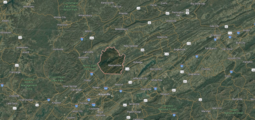
Union County is situated in northeastern Tennessee, bordered by Claiborne County to the north, Knox County to the south, and Grainger County to the east. It lies about 25 miles north of Knoxville and forms part of the Ridge-and-Valley region of the Appalachians. Norris Lake, created by the Clinch River, covers much of the county’s eastern edge and provides a defining feature.
Maynardville, the county seat, sits near the center and functions as the primary hub of commerce and government. Other communities include Luttrell in the southeastern part and Sharps Chapel along Norris Lake. With its combination of mountain ridges, lakefront areas, and rural farmland, Union County blends natural scenery with small-town life.
#9. Meigs County (tie)
– Life expectancy: 70.8 years
— 3.3 years lower than the state average
You may also like: Counties with the worst commutes in Tennessee

About
Meigs County sits along the Tennessee River in East Tennessee, where farmland and small towns shape its identity. Agriculture and river access have long supported the county’s economy, while local schools and civic institutions remain central to community life. Decatur serves as the county seat and main hub of activity.
Residents connect through school events, church gatherings, and county fairs that reinforce shared values. The river provides both recreation and opportunity, linking daily life to the landscape. Meigs County reflects a steady balance of rural tradition, community pride, and natural setting.
Where is Meigs County?
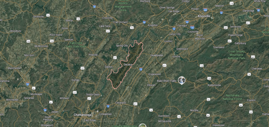
Meigs County is located in southeastern Tennessee, bordered by Roane County to the north, Hamilton County to the south, and the Tennessee River along its western edge. It lies about 50 miles southwest of Knoxville and 45 miles northeast of Chattanooga. The county’s geography includes river valleys, rolling farmland, and wooded hills characteristic of the Tennessee Valley.
Decatur, the county seat, is positioned near the center and serves as the hub for local government and community life. Smaller towns include Ten Mile in the northern section and Georgetown near the Hamilton County line. With the Tennessee River and Chickamauga Lake shaping its boundaries, Meigs County combines rural living with access to outdoor recreation.
#8. Gibson County (tie)
– Life expectancy: 70.8 years
— 3.3 years lower than the state average
About
Gibson County lies in West Tennessee, where rich farmland and early settlements gave rise to a strong agricultural tradition. Its towns, including Trenton, Humboldt, and Milan, reflect a long history of civic life, trade, and community pride. The county is also known for heritage festivals and cultural events that highlight its deep local roots.
Residents gather in town squares, at schools, and during seasonal celebrations that honor both history and progress. Farming remains important, while small industries and commerce add to the county’s role in the region. Gibson County represents a place where heritage, community, and rural life continue to shape its character.
Where is Gibson County?
Gibson County is in western Tennessee, bordered by Carroll County to the east, Madison County to the south, and Crockett County to the west. It sits about 25 miles north of Jackson and roughly 130 miles west of Nashville. The county’s landscape is made up of fertile farmland, gentle hills, and small streams that feed into the Forked Deer River system.
Trenton, the county seat, is located near the center and serves as the county’s administrative hub. Other towns include Milan to the south, Humboldt in the southwest, and Dyer to the north, creating a strong network of communities. With its agricultural foundation and series of active small towns, Gibson County represents an important part of west Tennessee’s rural character.
#7. Hardin County (tie)
– Life expectancy: 70.8 years
— 3.3 years lower than the state average
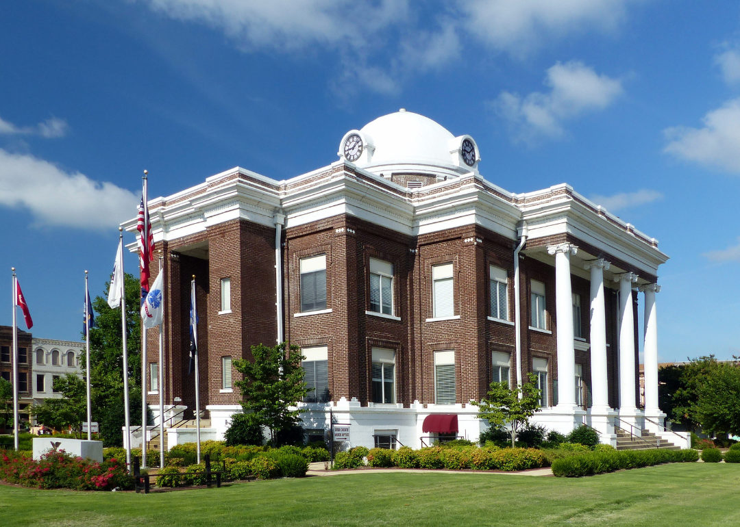
About
Hardin County rests along the Tennessee River in southwest Tennessee, where water and wooded hills define both setting and story. Its history is tied to river trade, agriculture, and the Civil War battlefields at Shiloh, which remain a lasting landmark of national significance. Savannah, the county seat, serves as a hub for civic life and regional commerce.
Residents find connection in riverfront festivals, school traditions, and community gatherings that reflect pride in both past and present. Outdoor life—fishing, boating, and exploring historic sites—keeps the landscape central to daily rhythms. Hardin County reflects a place where history, water, and community spirit flow together in enduring balance.
Where is Hardin County?
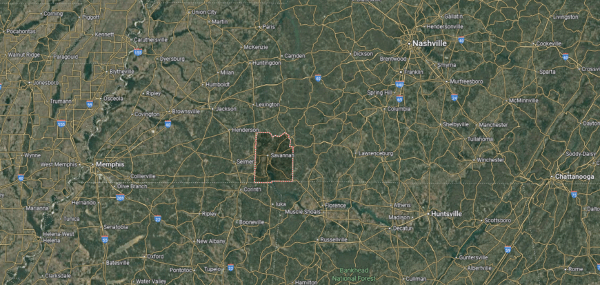
Hardin County is located in southwestern Tennessee, bordered by McNairy County to the west, Wayne County to the north, and the state of Mississippi to the south. The Tennessee River runs through its eastern side, creating a natural boundary and shaping much of the county’s geography. It lies about 110 miles east of Memphis and 95 miles southwest of Nashville.
Savannah, the county seat, sits along the Tennessee River and serves as the largest town and civic hub. Smaller communities include Crump to the west and Saltillo near the northern edge along the river. With Pickwick Landing State Park and Shiloh National Military Park nearby, Hardin County blends historical significance with river-centered recreation.
#6. Dyer County
– Life expectancy: 70.7 years
— 3.4 years lower than the state average
About
Dyer County sits in the northwest corner of Tennessee, where fertile Mississippi Delta soils have long supported strong agricultural traditions. Dyersburg, the county seat, serves as a hub for commerce, education, and regional industry. Farming, trade, and manufacturing together form the foundation of the county’s economy.
Community life is shaped by school athletics, festivals, and civic gatherings that reinforce local pride. Residents balance rural traditions with the opportunities of a growing regional center. Dyer County reflects a steady mix of agriculture, community, and modern development.
Where is Dyer County?
Dyer County is in northwestern Tennessee, bordered by Lake County to the west, Obion County to the north, and Lauderdale County to the south. The Mississippi River forms much of its western boundary, creating fertile floodplains that support agriculture. It lies about 75 miles north of Memphis and 45 miles west of Jackson.
Dyersburg, the county seat, is centrally located and serves as the primary commercial and cultural hub. Smaller communities include Newbern to the northeast and Trimble near the Obion County line. With its rich farmland and direct access to river transport, Dyer County has long been tied to agriculture and trade in west Tennessee.
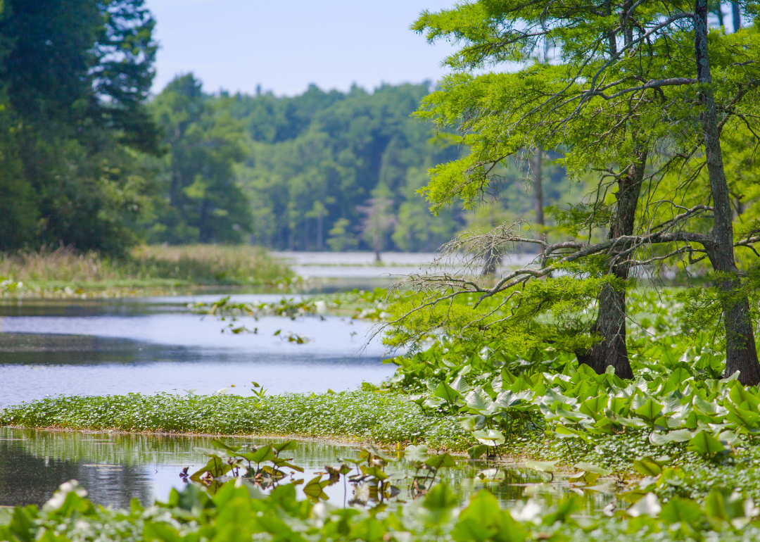
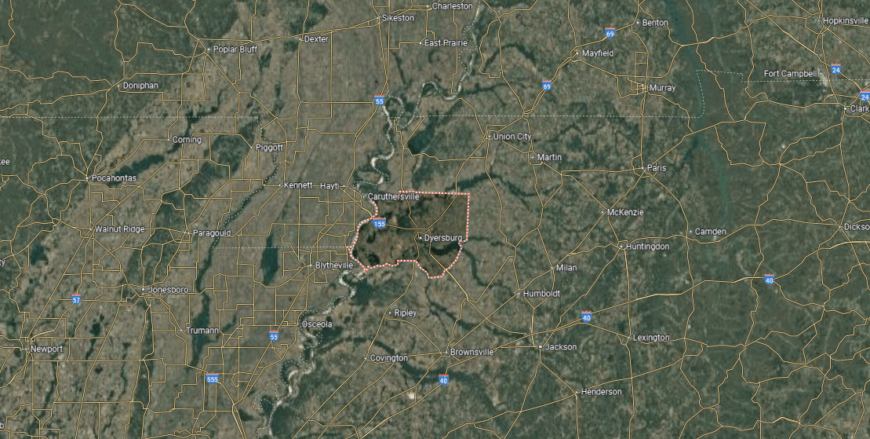
#5. Lake County
– Life expectancy: 70.1 years
— 4.0 years lower than the state average
About
Lake County, the smallest by population in Tennessee, is shaped by close-knit communities and a strong sense of place. Tiptonville, the county seat, serves as the center of government, schools, and local activity, keeping civic life steady and connected. Agriculture and small businesses support the economy alongside tourism drawn by Reelfoot Lake.
Local traditions are carried through school events, festivals, and neighborhood gatherings that keep residents engaged with one another. The county’s size fosters strong ties, where families often know one another across generations. Lake County represents a community where civic pride and local resilience remain deeply rooted.
Where is Lake County?
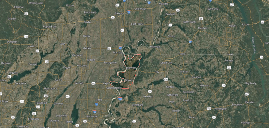
Lake County is positioned in the northwestern corner of Tennessee, bordered by Kentucky to the north, the Mississippi River to the west, and Obion County to the east. It lies about 150 miles north of Memphis and 200 miles northwest of Nashville. The county is the smallest in Tennessee by land area, with much of its landscape shaped by the river floodplain and the backwaters of Reelfoot Lake.
Tiptonville, the county seat, is located near the northern edge close to Reelfoot Lake. Smaller communities include Ridgely to the south and Wynnburg along the lake’s shoreline. With its unique natural setting, Lake County is defined by the presence of Reelfoot Lake, a major destination for fishing, birdwatching, and outdoor recreation.
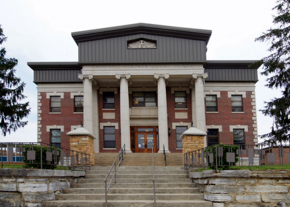
#4. Campbell County
– Life expectancy: 70.0 years
— 4.1 years lower than the state average
You may also like: Counties in Tennessee with more precipitation over the past year than average

About
Campbell County lies in East Tennessee, where the Cumberland Mountains and Norris Lake shape both the land and daily life. Its history is tied to coal mining, early settlement, and the growth of small towns that developed around mountain valleys and waterways. Today, the county blends those roots with a growing focus on recreation and tourism.
Residents connect through lakefront festivals, school traditions, and courthouse-centered gatherings that highlight community pride. Outdoor activities such as fishing, hiking, and boating link people closely to the natural surroundings. Campbell County reflects a community where mountain heritage and modern opportunity come together.
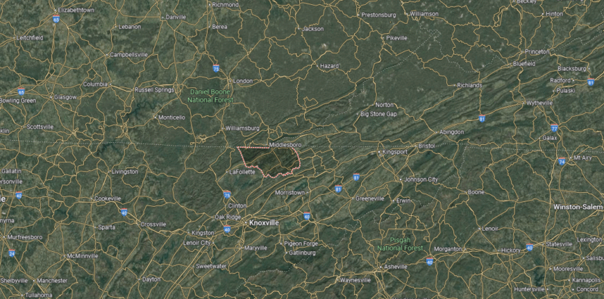
Where is Campbell County?
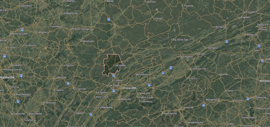
Campbell County is in northeastern Tennessee, bordered by Kentucky to the north, Anderson County to the south, and Claiborne County to the east. It lies about 40 miles north of Knoxville and sits within the Cumberland Mountains and the Powell Valley. The county’s terrain includes forested ridges, narrow valleys, and part of Norris Lake along its southern edge.
Jacksboro, the county seat, is located near the center and serves as the main hub of government. LaFollette, the largest city, sits to the northeast along U.S. Highway 25W, while Caryville lies closer to the lake and interstate access. With its mountain setting and lakefront areas, Campbell County blends rugged Appalachian landscapes with recreational opportunities.
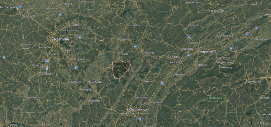
#3. Grundy County
– Life expectancy: 69.8 years
— 4.3 years lower than the state average
About
Grundy County rests high on the Cumberland Plateau, where cliffs, waterfalls, and deep forests shape both scenery and story. Its history is tied to coal mining towns, early mountain communities, and the rugged landscape that influenced settlement and work. The plateau’s wild beauty gives the county a distinct character rooted in endurance and nature.
Life here flows through small-town gatherings, church events, and outdoor traditions in parks and natural preserves. Families remain tied to the land, finding both challenge and connection in its ridges and valleys. Grundy County stands as a place where mountain spirit and community resilience remain inseparably bound.
Where is Grundy County?
Grundy County is located on the southern Cumberland Plateau in Tennessee, bordered by Coffee County to the west, Sequatchie County to the east, and Marion County to the south. It lies about 60 miles northwest of Chattanooga and 90 miles southeast of Nashville. The county’s geography is defined by plateau ridges, deep gorges, and the headwaters of several rivers and streams.
Altamont, the county seat, is positioned near the center on the plateau. Other communities include Tracy City to the east, Monteagle along the southern edge, and Coalmont nearby, all tied historically to coal mining. With natural attractions such as Fiery Gizzard Trail and South Cumberland State Park, Grundy County is known for its rugged terrain and outdoor recreation.
#2. Cocke County
– Life expectancy: 69.6 years
— 4.5 years lower than the state average
About
Cocke County sits in East Tennessee, where the Great Smoky Mountains meet the foothills of the French Broad and Pigeon Rivers. Its history is tied to farming, timber, and the early gateway it provided to mountain settlement. Newport, the county seat, serves as the center of commerce and civic life.
Community spirit shows in festivals, school traditions, and gatherings that highlight both heritage and progress. Outdoor recreation in the mountains and rivers adds to the county’s rhythm of daily life. Cocke County reflects a steady blend of natural setting, tradition, and local pride.
Where is Cocke County?
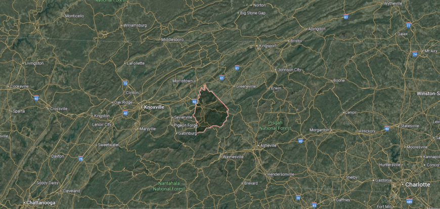
Cocke County is in eastern Tennessee, bordered by North Carolina to the east, Greene County to the north, and Sevier County to the west. It lies about 45 miles east of Knoxville and forms part of the Appalachian Mountain region, including sections of the Great Smoky Mountains and Cherokee National Forest. The French Broad and Pigeon Rivers run through the county, shaping its valleys and lowlands.
Newport, the county seat, is centrally located and serves as the largest town. Smaller communities include Parrottsville to the north and Cosby near the Smokies on the southern edge. With its combination of mountain ridges, river valleys, and national forest lands, Cocke County offers both rural living and access to scenic recreation.
#1. Van Buren County
– Life expectancy: 69.1 years
— 5.0 years lower than the state average
About
Van Buren County rests on the Cumberland Plateau, one of Tennessee’s smallest counties by population yet rich in history and natural character. Its communities grew from frontier settlements that relied on farming, timber, and the plateau’s rugged resources. The county seat, Spencer, reflects this heritage with its small-town traditions and civic gatherings.
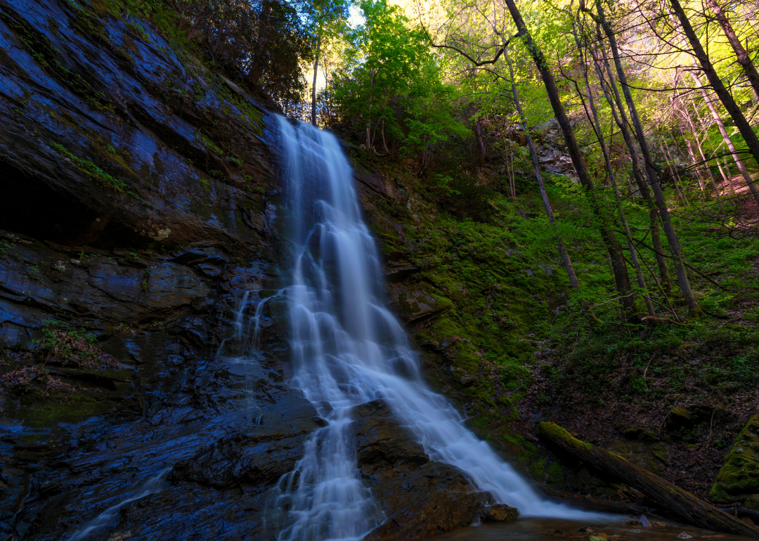
Life here is deeply tied to the land, with Fall Creek Falls State Park serving as both a landmark and a source of pride. Residents come together through school events, local festivals, and outdoor traditions that reinforce close community bonds. Van Buren County represents a place where history, land, and community remain tightly interwoven.
Where is Van Buren County?
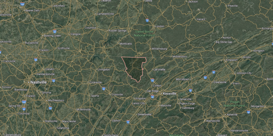
Van Buren County is located in central Tennessee, bordered by White County to the north, Bledsoe County to the east, and Warren County to the south. It lies about 70 miles northwest of Chattanooga and 100 miles southeast of Nashville. The county sits on the Cumberland Plateau, with rugged ridges, forested valleys, and streams shaping its landscape.
Spencer, the county seat, is positioned near the center and serves as the county’s main community. Other small settlements are scattered across the plateau, emphasizing its rural character. With Fall Creek Falls State Park extending into its borders, Van Buren County is closely tied to outdoor recreation and natural beauty.
This story features data reporting by Karim Noorani, writing by Kiersten Hickman, and is part of a series utilizing data automation across 49 states.
By Stacker