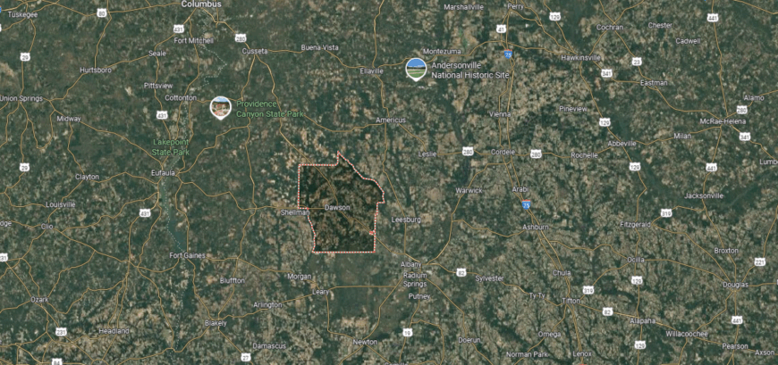
Counties with the shortest life expectancy in Georgia
Life expectancy can be affected by a variety of factors. About 25% of your lifespan is determined by genetics, according to the National Library of Medicine. Health and wellness habits—like following a balanced, nutrient-rich diet; not smoking; drinking minimal alcohol; maintaining a healthy weight; and staying physically active—can add more than a decade to your life, research from the National Institutes of Health shows. While these factors are significant, another important element that you might not have considered is your environment and community.
In order to come up with the very specific design ideas, we create most designs with the assistance of state-of-the-art AI interior design software.
While life expectancy generally increases annually in the United States—jumping from about 70.8 years old to 77.5 between 1970 and 2022, according to the Centers for Disease Control and Prevention—this particular metric can vary from state to state or even county to county. In some parts of the country, the average lifespan is getting shorter based on a variety of risk factors on top of health, including socioeconomic factors like poverty, unemployment, income, and education.
According to a 2020 study from researchers at Penn State, West Virginia, and Michigan State Universities, communities with a higher population density, more fast food restaurants, and a high number of extraction industry-based jobs tend to have shorter life expectancies.
To find out how life expectancy varies within Georgia, Stacker used 2024 County Health Rankings & Roadmaps from the University of Wisconsin Population Health Institute to identify the counties with the shortest life expectancy. Life expectancy measures the average number of years from birth a person can expect to live and is calculated based on the number of deaths in a given time period and the average number of people at risk of dying during that period. Counties with unreliable or insufficient data were excluded from the analysis. Mortality data came from the National Vital Statistics System.
Read on to see if your county is on the list.
You may also like: Highest-rated things to do in Georgia, according to Tripadvisor
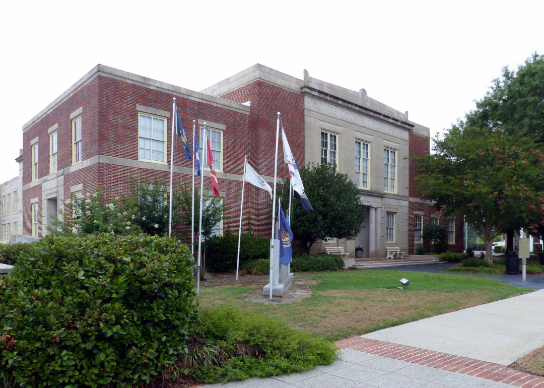
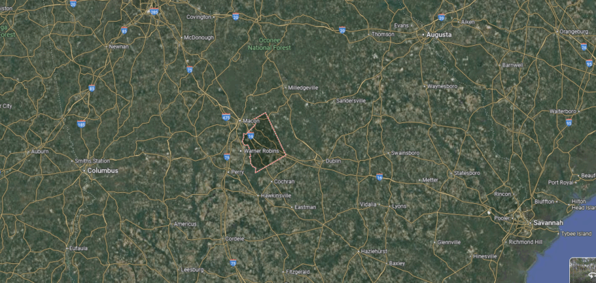
#50. Coffee County (tie)
– Life expectancy: 72.4 years
— 3.7 years lower than the state average
About
Coffee County in south-central Georgia is defined by its blend of timberlands, farmland, and a steady industrial base that anchors its economy. The county seat, Douglas, serves as a hub of commerce and education, balancing small-town living with regional influence. Its landscape of pine forests and agricultural fields reflects both natural resources and long-standing rural work.
Community life here revolves around local schools, civic events, and regional fairs that draw families together year after year. Aviation and manufacturing have added new layers to its agricultural roots, shaping opportunities for growth while preserving its heritage. Coffee County stands as a place where tradition and progress meet in a grounded way.
Where is Coffee County?
Coffee County lies in south-central Georgia, about 60 miles northeast of Valdosta and roughly 120 miles northwest of Jacksonville, Florida. It is bordered by Irwin and Telfair counties to the north, Jeff Davis to the east, Atkinson to the south, and Ben Hill and Berrien to the west. The county’s terrain features flat farmland, pine stands, and the Satilla River running along its southeastern edge.
Douglas, the county seat, anchors the area with a mix of commerce and education. Smaller towns such as Nicholls, Ambrose, and Broxton highlight the county’s agricultural roots, while rural communities spread across the landscape give Coffee County its distinct small-town Georgia character.
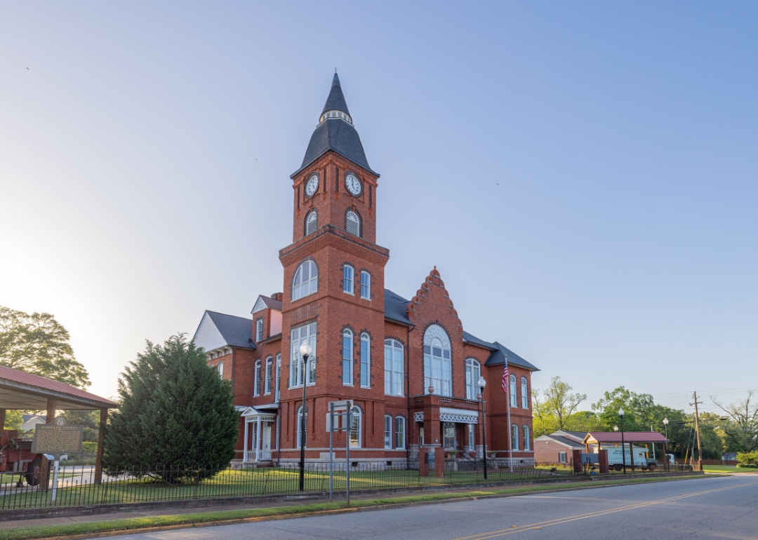
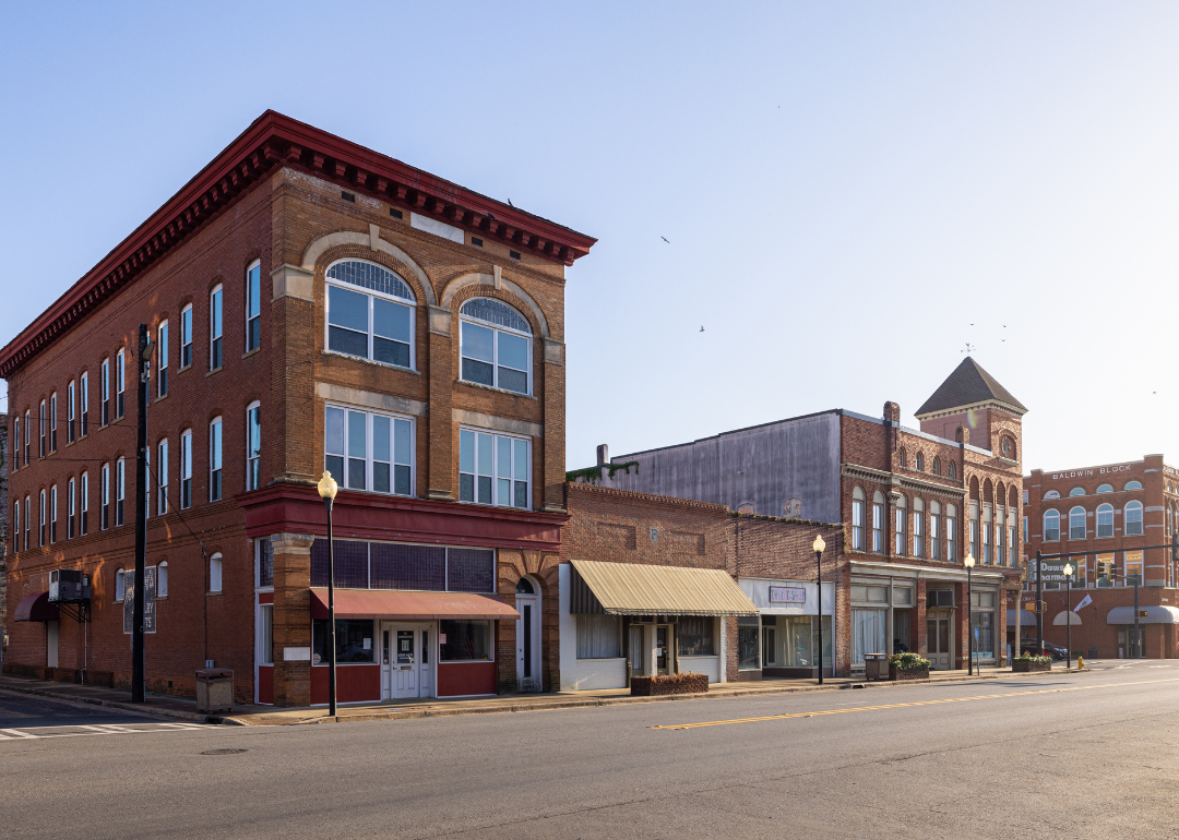
#49. Sumter County (tie)
– Life expectancy: 72.4 years
— 3.7 years lower than the state average
About
Sumter County, Georgia carries a strong agricultural foundation blended with historic significance and small-town traditions. Its communities reflect a rural character shaped by farmland, civic institutions, and enduring ties to the land that support daily life. Americus, the county seat, adds a cultural and educational presence, while nearby Plains is closely tied to the legacy of President Jimmy Carter.
Residents gather around schools, churches, and seasonal events that strengthen local connections. Life moves at a steady, grounded pace, with generational pride in farming, community service, and heritage guiding much of its identity. Sumter County remains a reflection of rural Georgia’s resilience and shared values.
Where is Sumter County?
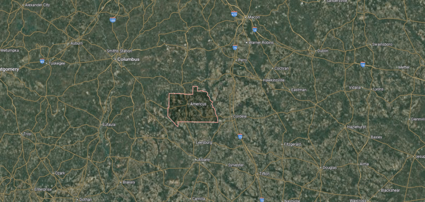
Sumter County is located in southwestern Georgia, about 135 miles south of Atlanta and 70 miles east of Columbus. It shares borders with Schley, Macon, Dooly, Crisp, Lee, and Webster counties, with a landscape of farmland, pine forests, and winding creeks.
Americus serves as the county seat and largest city, positioned near the center of the county. Plains, the hometown of President Jimmy Carter, and Andersonville, known for its Civil War prison site, stand out alongside smaller rural towns such as Leslie and DeSoto.
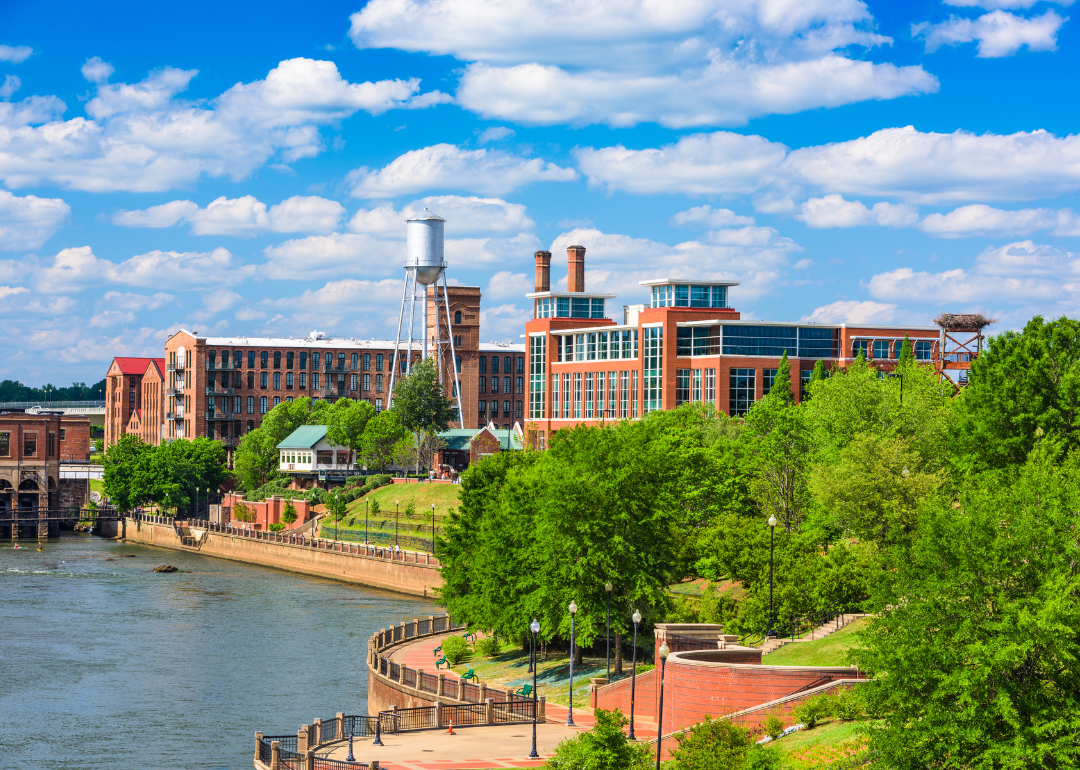
#48. Muscogee County (tie)
– Life expectancy: 72.3 years
— 3.8 years lower than the state average
About
Muscogee County, Georgia covers a broad stretch of the Chattahoochee River Valley, with Columbus as both its county seat and largest city. The county is home to a mix of historic neighborhoods, riverfront development, and Fort Moore, one of the nation’s major military installations. Its economy reflects a balance of military presence, manufacturing, healthcare, and education, giving it a role as a regional center.
Daily life in Muscogee County blends cultural institutions, recreational opportunities along the river, and a strong sense of civic involvement. The community supports festivals, arts venues, and outdoor activities, while maintaining a connection to its history as a hub for commerce and industry. Rooted in tradition but always looking forward, the county reflects the resilience and vitality of west Georgia.
Where is Muscogee County?
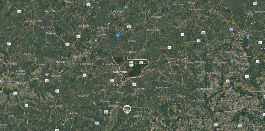
Muscogee County rests on Georgia’s western border, where the Chattahoochee River separates it from Alabama. Positioned about 100 miles southwest of Atlanta, the county is smaller in size but densely developed, with a mix of urban neighborhoods, green spaces, and riverfront stretches.
At its center is Columbus, both the county seat and one of Georgia’s major cities. The presence of Fort Moore shapes much of the local economy and community, while historic districts, cultural venues, and the revitalized riverfront give Muscogee a character that blends military roots with modern city life.
#47. Randolph County (tie)
– Life expectancy: 72.3 years
— 3.8 years lower than the state average
About
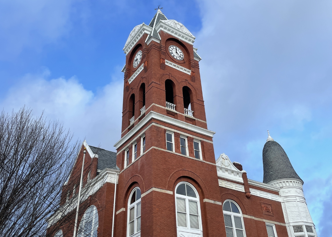
Randolph County, located in southwest Georgia, spans just over 430 square miles and is home to a small population that has historically relied on agriculture. The county seat, Cuthbert, serves as the cultural and civic center, with ties to farming and forestry shaping much of the local economy. Rolling farmland, quiet woodlands, and rural communities reflect its place in Georgia’s historic agricultural belt.
Life in Randolph County is closely connected to the land and to the heritage of its residents. Community events, local schools, and churches provide gathering points that strengthen social ties. With its modest size and deep roots, the county embodies a slower rhythm of life and a strong sense of place in the state’s rural landscape.
Where is Randolph County?
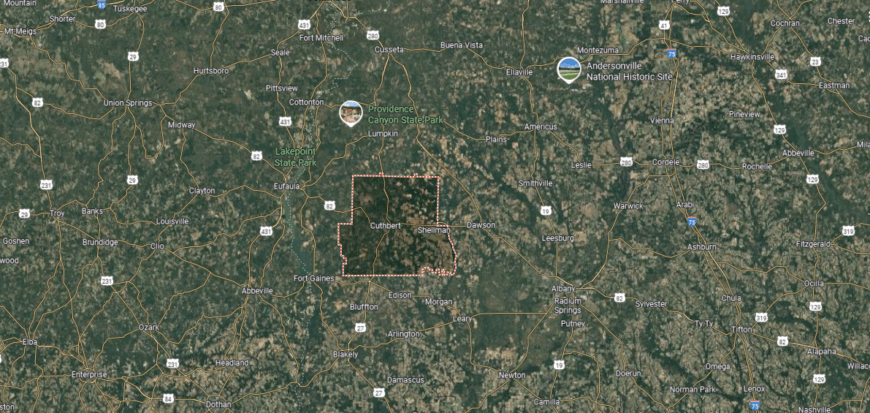
Randolph County lies in the southwest region of Georgia, about 65 miles south of Columbus and 50 miles northwest of Albany. It is bordered by Stewart County to the north, Terrell to the east, Calhoun to the southeast, Clay to the west, and Quitman to the southwest. The county’s landscape is defined by rolling farmland, timber tracts, and the nearby Chattahoochee River along its western edge.
Cuthbert serves as the county seat, located near the center of Randolph County. Smaller towns and communities such as Shellman and Coleman contribute to its rural setting, while historic sites and old town squares reflect the county’s deep agricultural and cultural roots in southwest Georgia.
#46. Haralson County (tie)
– Life expectancy: 72.3 years
— 3.8 years lower than the state average
You may also like: Counties with the most homes selling under list price in Georgia
About
Haralson County, set along Georgia’s western border with Alabama, spans about 283 square miles and is anchored by the city of Buchanan as its county seat. Founded in 1856, the county’s landscape ranges from rolling hills to quiet farmlands, while its towns reflect both historic roots and steady community growth. Manufacturing, agriculture, and small businesses shape much of the local economy, alongside easy access to larger markets in nearby Atlanta.
Residents value the county’s balance of rural charm and community connection, often gathering at local schools, churches, and seasonal fairs. Outdoor recreation thrives in its parks and natural spaces, while a commitment to preserving history can be seen in landmarks and restored structures. Haralson County stands as a reminder of west Georgia’s enduring traditions and practical, close-knit way of life.
Where is Haralson County?
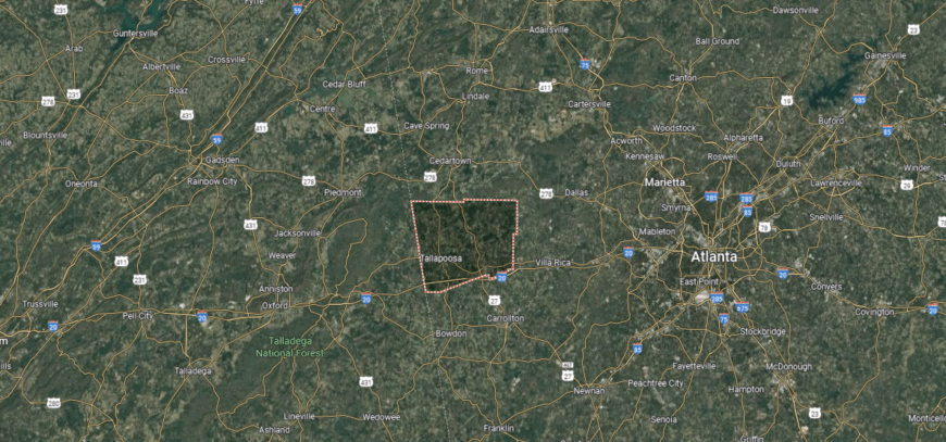
Haralson County is located in the northwestern part of Georgia, along the Alabama state line. It sits about 55 miles west of Atlanta and is bordered by Polk County to the north, Carroll County to the east, and Alabama’s Cleburne and Randolph counties to the west. The county is characterized by rolling hills, woodlands, and farmland, with parts of the Tallapoosa River and its tributaries flowing through the area.
Buchanan is the county seat and lies near the center of Haralson County, while Bremen and Tallapoosa are its other notable towns. The county combines quiet rural communities with historic districts and has long been tied to agriculture, small industry, and its position as a gateway between Georgia and eastern Alabama.
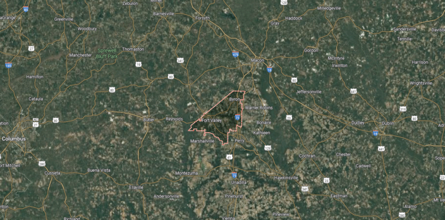
#45. Peach County (tie)
– Life expectancy: 72.3 years
— 3.8 years lower than the state average
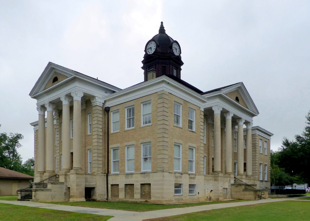
About
Peach County, Georgia spans just over 150 square miles in the heart of the state and is anchored by the communities of Fort Valley and Byron. Established in 1924, it is the state’s youngest county and takes its name from Georgia’s famed peach industry, which remains central to its agricultural economy. Beyond peaches, row crops and agribusiness contribute to its identity, while institutions like Fort Valley State University add educational and cultural depth.
Life in Peach County reflects a close connection to both farmland and small-town traditions. Residents gather at local festivals celebrating the peach harvest, and the county’s central location offers easy access to nearby cities while maintaining its own grounded rhythm. With its agricultural heritage and community-centered spirit, Peach County captures a distinctive slice of Georgia’s rural landscape.
Where is Peach County?
🔥 Would you like to save this?
Peach County is located in central Georgia, about 100 miles south of Atlanta and 25 miles southwest of Macon. It is the state’s newest county, created in 1924, and covers a relatively small area bordered by Crawford, Houston, Macon, and Taylor counties. The landscape includes fertile farmland, orchards, and gently rolling hills that reflect its agricultural heritage.
Fort Valley serves as the county seat and is home to Fort Valley State University, a historically Black university. The city is also closely associated with the peach industry, as the county is one of Georgia’s leading producers of the fruit. Other communities, such as Byron and Powersville, contribute to the county’s mix of education, farming, and small-town life.
#44. Irwin County (tie)
– Life expectancy: 72.3 years
— 3.8 years lower than the state average
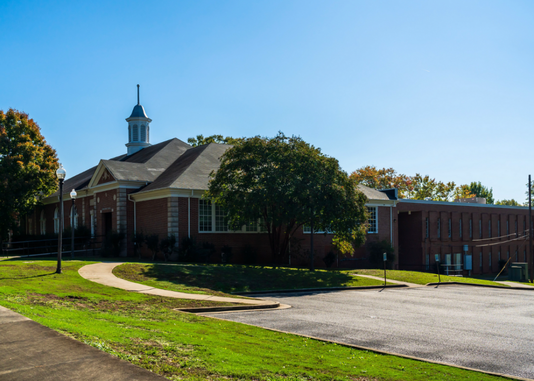
About
Irwin County, set in south-central Georgia, stretches across more than 350 square miles of farmland, pine stands, and small communities. Ocilla, the county seat, anchors civic and cultural life while serving as a hub for surrounding rural areas. Agriculture—particularly row crops and livestock—has long been the backbone of the county’s economy, tying residents closely to the land.
Community identity here is strengthened through school activities, local festivals, and gatherings that highlight both tradition and neighborly ties. The pace of life remains steady and rooted, with families often connected through generations of farming and rural work. Irwin County endures as a portrait of south Georgia’s resilience, where land and heritage remain central to everyday living.
Where is Irwin County?
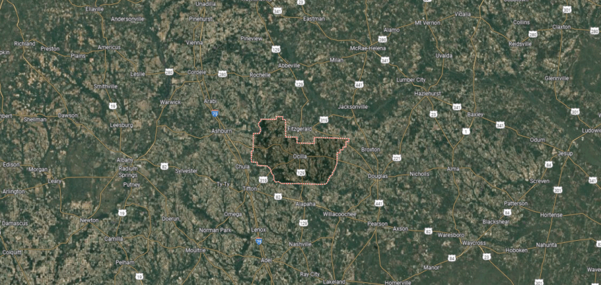
Irwin County sits in south-central Georgia, about 45 miles northeast of Tifton and 65 miles southeast of Cordele. It shares borders with Ben Hill to the north, Coffee to the east, Berrien to the south, and Turner and Tift counties to the west. The county is largely rural, with farmland, timberlands, and stretches of the Alapaha River shaping its landscape.
Ocilla is the county seat and serves as the center of local government and commerce. Surrounding communities such as Mystic and Wray reflect the area’s agricultural roots, while the county as a whole is known for farming, forestry, and its deep ties to small-town Georgia traditions.
#43. Spalding County (tie)
– Life expectancy: 72.3 years
— 3.8 years lower than the state average
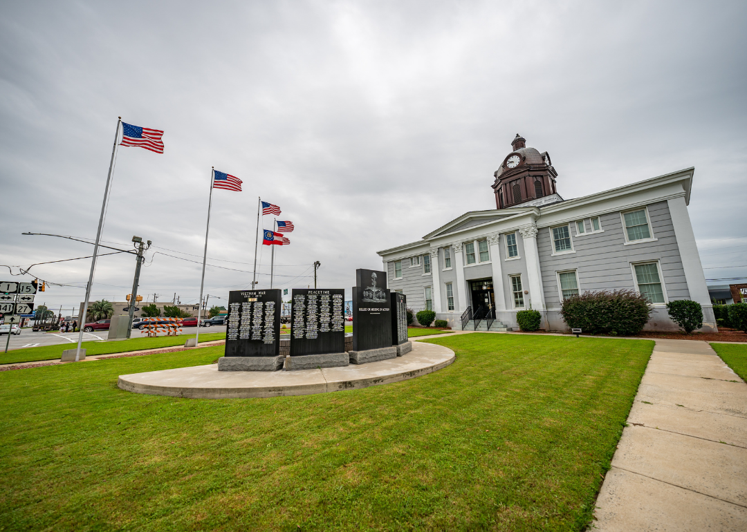
About
Spalding County, located in west-central Georgia, was founded in 1851 and centers around Griffin, its county seat and largest city. The county developed as a transportation and trade hub, first with cotton and textiles, and later with manufacturing and commerce that continue to influence its economy. Its location south of Atlanta gives it both a regional role and a strong connection to metropolitan growth.
Life in Spalding County blends historic neighborhoods, active civic institutions, and a steady rhythm of community gatherings. Residents take part in local festivals, recreation programs, and cultural events that tie together city and rural life. With its balance of tradition, industry, and community pride, Spalding County reflects a distinctive part of Georgia’s heartland.
Where is Spalding County?
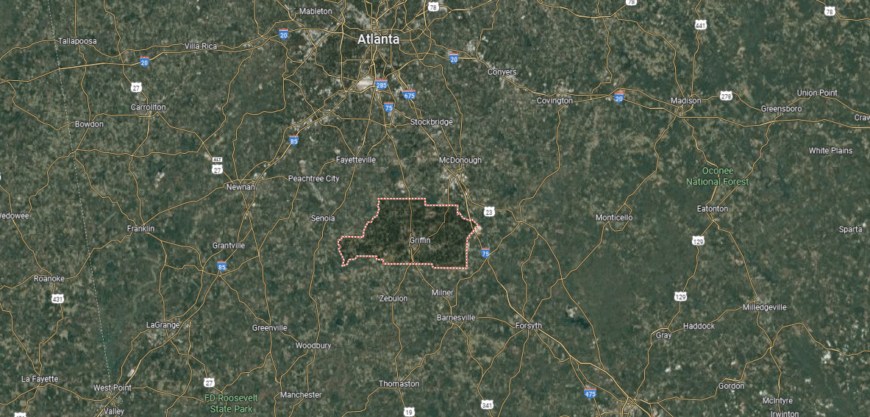
Spalding County lies in west-central Georgia, about 40 miles south of Atlanta and 30 miles north of Macon. It is bordered by Henry County to the north, Butts and Lamar to the east, Pike to the south, and Coweta and Fayette to the west. The county’s setting includes rolling hills, farmland, and growing suburban neighborhoods tied closely to the Atlanta metropolitan area.
Griffin, the county seat, is the largest city and serves as the hub of commerce, schools, and government. Smaller communities like Sunnyside, Orchard Hill, and Experiment add to the mix of rural and suburban life, while the county’s location keeps it connected to both agricultural traditions and expanding urban development.
#42. Appling County
– Life expectancy: 72.2 years
— 3.9 years lower than the state average
About
Appling County, in southeast Georgia, covers more than 500 square miles of farmland, pine forests, and waterways that have long supported its economy. The county seat, Baxley, serves as a hub for trade, education, and community events, while agriculture and timber remain central to local life. Its landscape and resources have shaped a steady rhythm of work and tradition for generations.
Residents maintain strong ties through churches, schools, and gatherings that celebrate both heritage and seasonal milestones. Festivals highlight local culture, while outdoor recreation on rivers and in woodlands brings people together. Appling County continues to embody a rural Georgia spirit—rooted in natural resources, close community bonds, and enduring pride in its way of life.
Where is Appling County?
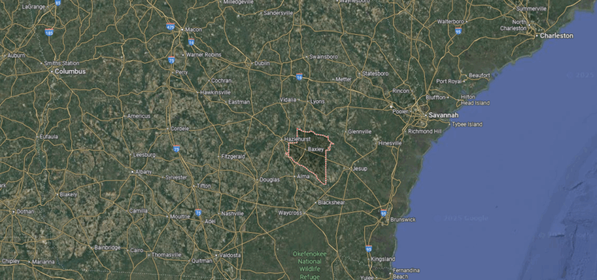
Appling County is positioned in southeastern Georgia, about 70 miles northwest of Brunswick and 100 miles southwest of Savannah. It is bordered by Jeff Davis County to the north, Wayne and Pierce to the east, Bacon to the south, and Tattnall and Toombs to the west. The county’s terrain is a mix of flat farmland, pine forests, and waterways, with the Altamaha River forming part of its northern boundary.
Baxley serves as the county seat and main commercial center. Surrounding towns and rural communities highlight the county’s ties to forestry, agriculture, and small-town living, while the nearby river and woodlands remain important to both its economy and outdoor recreation.
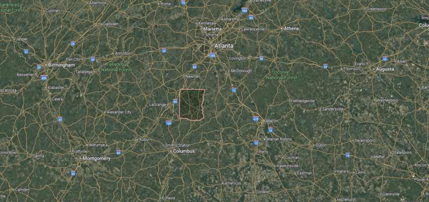
#41. Crawford County (tie)
– Life expectancy: 72.1 years
— 4.0 years lower than the state average
You may also like: Best lookout points in Georgia
About
Crawford County, located in central Georgia, is one of the state’s smaller counties, covering about 325 square miles with Knoxville as its county seat. Established in 1822, it retains a deeply rural identity marked by farmland, woodlands, and a close connection to the land. Agriculture, particularly row crops and timber, continues to anchor its economy while preserving its historic character.
The community thrives on its strong traditions, where schools, churches, and local events remain at the center of social life. Residents value the slower pace and generational ties that have shaped the county for nearly two centuries. Crawford County stands as a quiet example of central Georgia’s enduring rural heritage and close-knit way of living.
Where is Crawford County?

Crawford County is located in central Georgia, about 20 miles west of Macon and 90 miles south of Atlanta. It borders Monroe and Bibb counties to the east, Peach and Houston to the south, Taylor to the southwest, and Upson to the west. The county’s landscape is shaped by rolling farmland, hardwood forests, and stretches of the Flint River along its western edge.
Knoxville, the county seat, is a small community near the center of Crawford County, while Roberta serves as its largest town and commercial hub. The area is known for its quiet rural character, agricultural roots, and historic ties dating back to Georgia’s early settlement period.
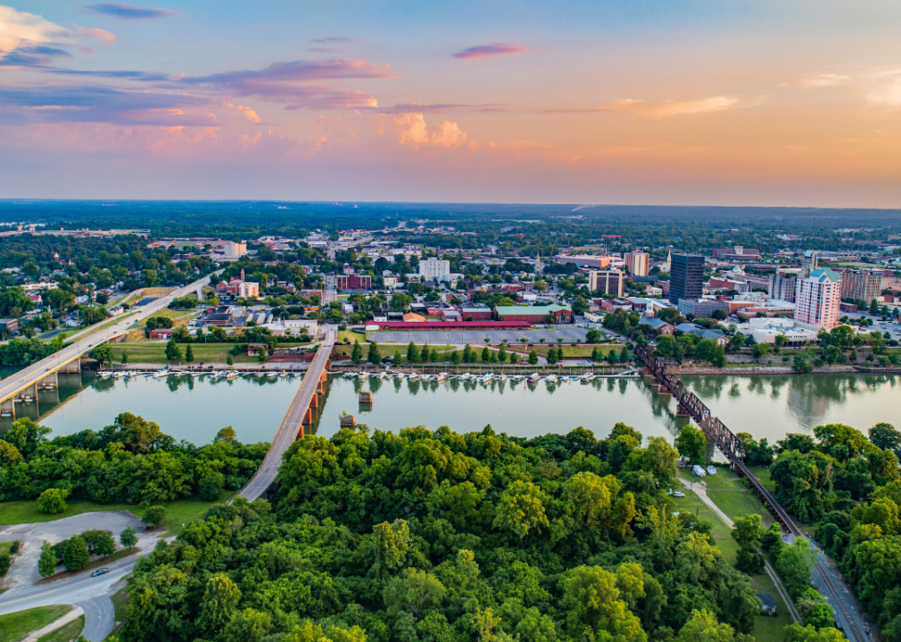
#40. Richmond County (tie)
– Life expectancy: 72.1 years
— 4.0 years lower than the state average
About
Richmond County, located along Georgia’s eastern border with South Carolina, is home to the city of Augusta, one of the state’s largest and most historic urban centers. Established in 1777, the county developed as a hub of trade and industry along the Savannah River and is widely recognized for hosting the prestigious Masters Tournament at Augusta National Golf Club.
Beyond golf, Richmond County has a diverse economy that includes healthcare, manufacturing, education, and a strong military presence through Fort Eisenhower (formerly Fort Gordon). Historic neighborhoods, the Augusta Canal National Heritage Area, and a vibrant cultural scene add depth to community life. With its balance of tradition, industry, and recreation along the riverfront, Richmond County holds a central place in Georgia’s history and development.
Where is Richmond County?

Richmond County lies along the eastern border of Georgia, with the Savannah River forming its boundary with South Carolina. It sits about 150 miles east of Atlanta and spans a mix of rolling hills, pine forests, and fertile river plains. The county’s location has long made it a crossroads for trade and culture in the region.
At its heart is Augusta, one of Georgia’s largest and most historic cities, known worldwide for hosting the Masters Golf Tournament. The community blends Southern tradition with a growing medical and manufacturing economy, supported by institutions like Augusta University. Beyond its economic role, Richmond County carries a sense of heritage and pride that makes it both significant and distinct within the state.
#39. Brantley County (tie)
– Life expectancy: 72.1 years
— 4.0 years lower than the state average
About
Brantley County, located in southeastern Georgia, was established in 1920, making it one of the state’s newer counties. The county seat is Nahunta, a small town that serves as the center of government and community life. Bordered by rivers and pine forests, the area has long been associated with agriculture, forestry, and outdoor recreation.
The county retains a quiet, rural character, where traditions of farming and close community ties remain strong. Residents enjoy the natural beauty of the Satilla River and access to the nearby Okefenokee Swamp, which provides opportunities for fishing, hunting, and exploring diverse ecosystems. Brantley County offers a slower pace of life rooted in the landscapes and heritage of coastal Georgia.
Where is Brantley County?
🔥 Would you like to save this?
Brantley County is located in southeastern Georgia, where pine forests and wetlands stretch toward the Satilla and Altamaha Rivers. It lies about 20 miles southwest of Brunswick and is bordered by Wayne, Glynn, Camden, Charlton, and Pierce counties. The terrain is mostly flat and rural, with open farmland, cypress swamps, and quiet back roads defining much of the scenery.
Nahunta serves as the county seat and is the largest community, with smaller towns like Hoboken and Atkinson scattered nearby. Outdoor lovers find opportunities for fishing, boating, and wildlife viewing along the Satilla River and in the Okefenokee Swamp. Brantley County carries a peaceful, small-town rhythm, offering a slower pace of life tied closely to the land and water.
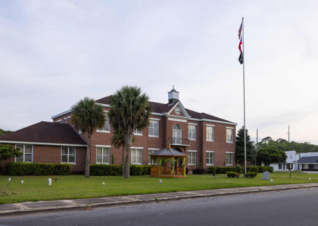
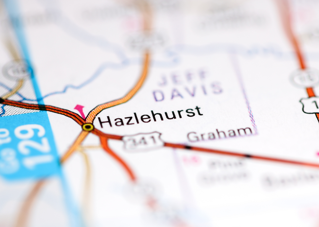
#38. Jeff Davis County (tie)
– Life expectancy: 72.0 years
— 4.1 years lower than the state average
About
Jeff Davis County, in south Georgia, was formed in 1905 and covers just over 330 square miles of farmland, forests, and small towns. Hazlehurst, the county seat, serves as the focal point for commerce, education, and civic life, while agriculture and timber continue to shape the local economy. Its location along major transportation routes has also supported steady growth in trade and industry.
Community life in Jeff Davis County is closely tied to schools, churches, and seasonal gatherings that highlight both tradition and neighborly bonds. Outdoor activities on the nearby Altamaha River add another layer to daily living, offering recreation and connection to the land. With its mix of rural heritage and steady development, the county reflects the enduring character of south Georgia.
Where is Jeff Davis County?
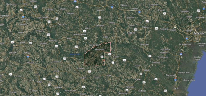
Jeff Davis County lies in south-central Georgia, well over 90 miles southeast of Macon and about 60 miles northwest of Brunswick. It is bordered by Wheeler County to the north, Telfair to the northwest, Appling to the southeast, Bacon to the south, Coffee to the southwest, and Montgomery to the northeast. The Ocmulgee River shapes much of its western boundary, while stretches of pine forest and farmland dominate its landscape.
Hazlehurst, the county seat, sits near the center and serves as the hub of commerce, government, and education. Smaller towns like Denton and Satilla highlight the rural character of the area. With its mix of agriculture, timber, and river access, Jeff Davis County anchors a quiet stretch of Georgia that connects east-central farmland with the pine flatwoods closer to the coast.
#37. Dodge County (tie)
– Life expectancy: 72.0 years
— 4.1 years lower than the state average
About
Dodge County, situated in central Georgia, was created in 1870 and spans more than 500 square miles of farmland, pine woods, and small communities. Eastman, the county seat, has long been the hub of government, trade, and culture, and is home to Georgia’s first state-designated Main Street city. Agriculture, timber, and small industries remain vital to the economy, blending tradition with gradual growth.
Life in Dodge County centers on community institutions, school events, and seasonal festivals that bring residents together. The Ocmulgee River adds natural beauty and recreational opportunities, while local heritage continues to shape identity and pride. Dodge County remains a portrait of central Georgia’s rural strength and enduring community ties.
Where is Dodge County?
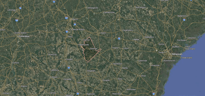
Dodge County is located in central Georgia, about 60 miles southeast of Macon and bordered by Laurens, Telfair, Pulaski, and Wilcox counties. The Ocmulgee River flows along its western edge, and the county’s landscape is marked by pine forests, farmland, and quiet rural stretches.
Eastman, the county seat, serves as the economic and cultural center, known historically for its ties to the timber and agriculture industries. Smaller towns like Chauncey, Chester, and Rhine contribute to the county’s laid-back character. With its open fields, river access, and close-knit communities, Dodge County blends Southern tradition with the quiet pace of countryside living.
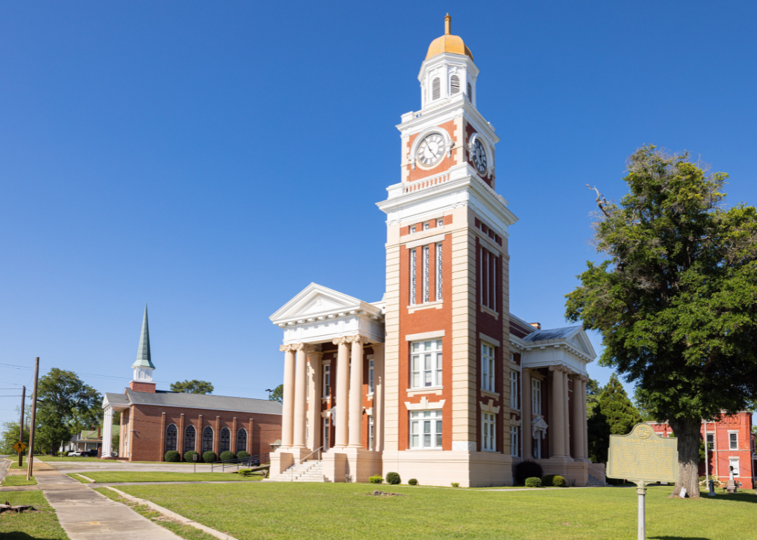
#36. Berrien County (tie)
– Life expectancy: 72.0 years
— 4.1 years lower than the state average
You may also like: Healthy hotspots: The most physically active counties in Georgia
About
Berrien County, in south-central Georgia, was established in 1856 and covers more than 450 square miles of farmland, forests, and small communities. Nashville, the county seat, serves as the center of government and commerce, surrounded by a landscape shaped by agriculture, particularly row crops and livestock. Its rural setting has preserved a way of life closely tied to the land and local traditions.
Residents gather around schools, churches, and county events that highlight community spirit and shared heritage. Outdoor recreation along area rivers and woodlands adds to daily life, offering both work and leisure connected to the natural environment. Berrien County continues to reflect the enduring resilience and neighborly character of south Georgia.
Where is Berrien County?
Berrien County is located in south-central Georgia, about 40 miles north of Valdosta and 30 miles east of Tifton. It is bordered by Irwin County to the north, Coffee to the northeast, Atkinson to the southeast, Lanier to the south, Cook to the west, and Tift to the northwest. The Alapaha River winds along its eastern side, contributing to the county’s geography of rolling farmland and pine woods.
The county seat, Nashville, is centrally positioned and serves as the civic and economic anchor. Smaller communities such as Enigma, Alapaha, and Ray City emphasize the county’s agricultural and small-town roots. Its location along major routes ties Berrien both to the farm belt of Tifton and the trade hub of Valdosta, giving it a dual character as a rural county with easy access to larger centers.
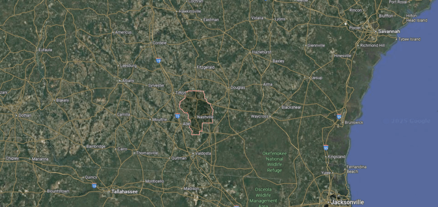
#35. Turner County (tie)
– Life expectancy: 72.0 years
— 4.1 years lower than the state average
About
Turner County, carved out of Georgia’s heartland in 1905, is among the state’s younger counties but carries a strong rural legacy. Ashburn, its county seat, is known for its towering peanut monument and its role as a stop along major highways that connect travelers across the region. Agriculture remains the backbone, with peanuts, cotton, and livestock shaping much of the local economy.
What sets Turner apart is the way it celebrates itself—most notably through the Fire Ant Festival, a quirky and well-loved tradition that draws crowds each year. Beyond the festival, life is marked by the closeness of schools, churches, and family networks that define the community. Turner County continues to reflect a small but spirited slice of Georgia’s rural identity.
Where is Turner County?
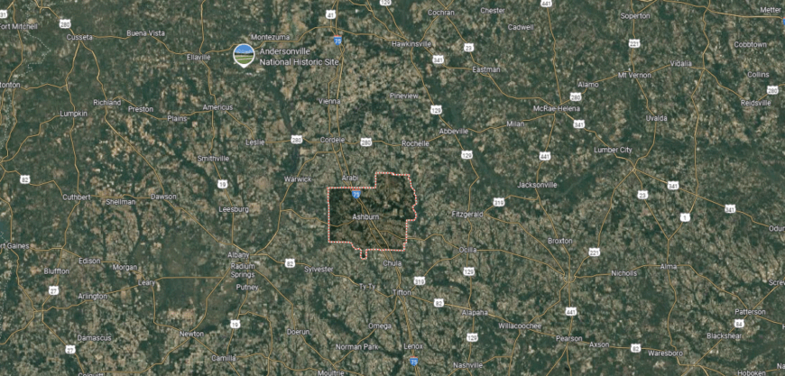
Turner County is set in south-central Georgia, about 65 miles southeast of Macon and 25 miles south of Cordele. It is bordered by Wilcox County to the north, Ben Hill to the east, Irwin to the southeast, Tift to the south, and Crisp and Worth to the west. The county’s landscape is primarily farmland, with open fields and stretches of pine forest shaping its scenery.
Located along Interstate 75, Turner County sits in a convenient position between Macon and Valdosta, making it part of a key travel corridor through the state. Its communities reflect a mix of small-town life and agricultural tradition, rooted in the heart of Georgia’s farming region.
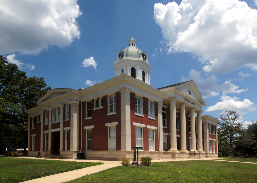
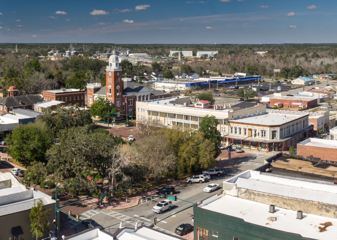
#34. Stephens County (tie)
– Life expectancy: 71.9 years
— 4.2 years lower than the state average
🔥 Would you like to save this?
About
Stephens County rests in the foothills of northeast Georgia, where the Appalachian Mountains begin to rise and the Tugaloo River winds along its edge. Created in 1905, the county quickly found its identity in both natural beauty and industry, with Toccoa serving as its civic and cultural center. Toccoa Falls, a dramatic 186-foot waterfall, stands as one of its most recognized landmarks and symbolizes the county’s deep ties to its landscape.
The community blends mountain traditions with small-town life, balancing manufacturing and education with outdoor recreation. Festivals, music, and local gatherings highlight the area’s cultural pride, while scenic trails and rivers connect residents to the land. Stephens County remains a place where natural splendor and human activity are inseparably linked.
Where is Stephens County?
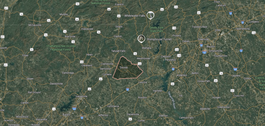
Stephens County is located in the northeastern corner of Georgia, about 95 miles northeast of Atlanta and 50 miles from Athens. It shares borders with Habersham County to the west, Franklin to the south, Banks to the southwest, and Oconee County, South Carolina, to the north and east, with the Tugaloo River forming much of that boundary. The Blue Ridge foothills roll across the county, creating a mix of valleys, ridges, and waterways.
Its position places it within easy reach of both the South Carolina Upstate and the mountain region of northeast Georgia. Lake Hartwell and Tugaloo State Park highlight the outdoor setting, while the area connects rural landscapes with nearby regional hubs. This location gives Stephens County both a mountain charm and a strong cross-state connection.
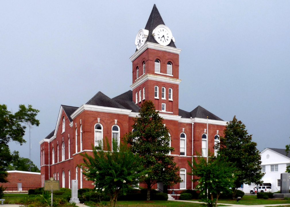
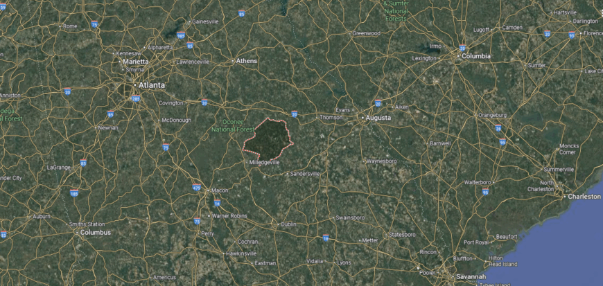
#33. Decatur County (tie)
– Life expectancy: 71.9 years
— 4.2 years lower than the state average
About
Decatur County, set in Georgia’s far southwest corner, is defined by the Flint River and Lake Seminole, which shape both its landscape and its way of life. Founded in 1823, it has long been a crossroads of river transport, agriculture, and trade, with Bainbridge as its county seat. Farming remains central, but the waterways add layers of recreation, fishing, and natural resource management.
Community life here leans on both tradition and the outdoors. Residents gather for festivals on the riverfront, local sports, and cultural events that highlight the county’s heritage. With fertile soil, abundant water, and a close-knit spirit, Decatur County reflects a distinctive mix of history, land, and community along Georgia’s southern border.
Where is Decatur County?
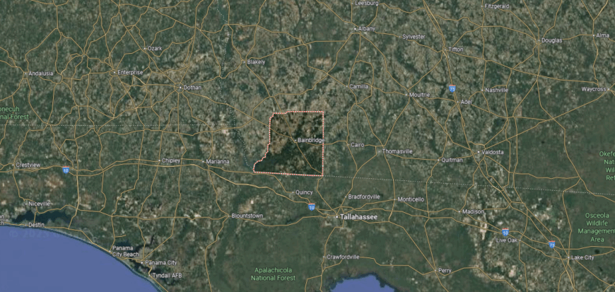
Decatur County sits in the far southwestern corner of Georgia, about 40 miles west of Thomasville and 60 miles north of Tallahassee, Florida. It shares borders with Seminole County to the west, Miller and Mitchell to the north, Grady to the east, and Gadsden County, Florida, to the south. The Flint River flows through the county, widening into Lake Seminole along its western edge.
Its location near the Florida line makes it a crossroads between south Georgia and the Florida Panhandle. The combination of river access, farmland, and forested areas defines the county’s landscape, while its setting along major routes ties it to both agricultural markets and nearby urban centers.
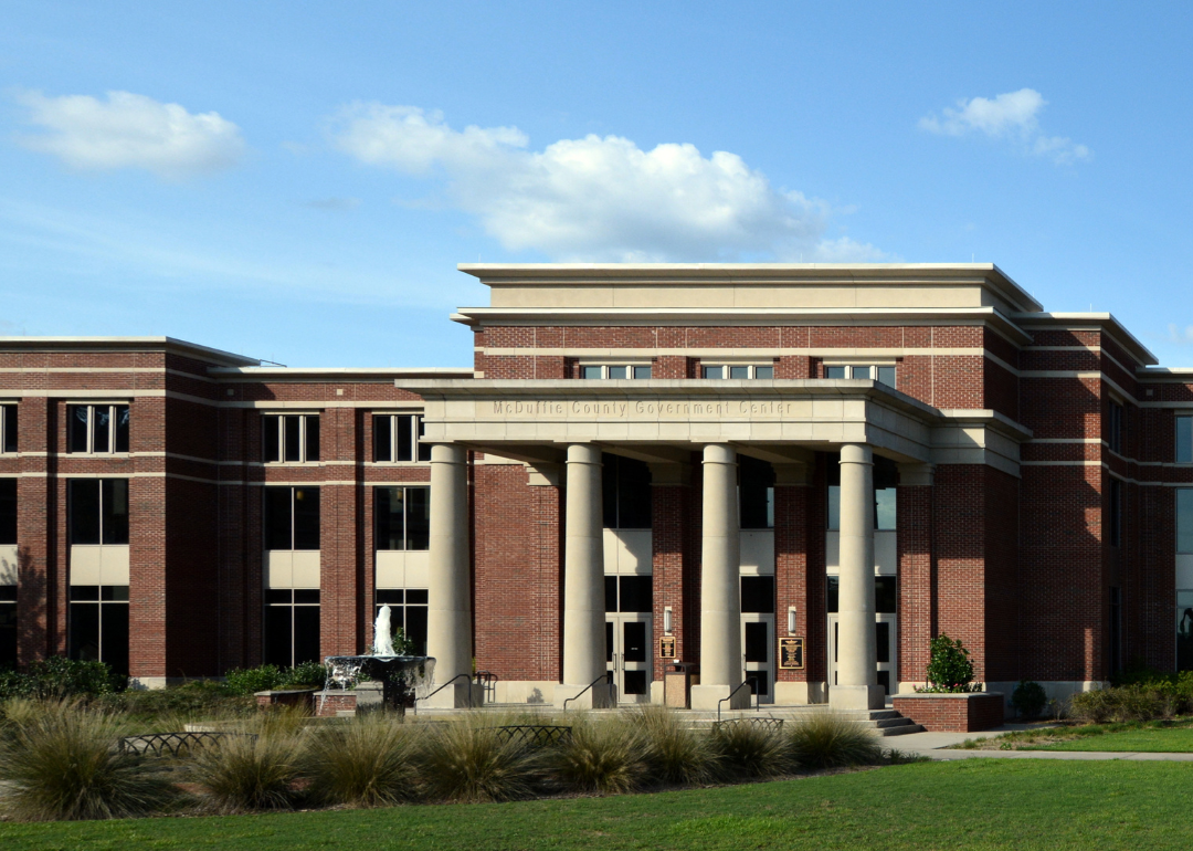
#32. McDuffie County (tie)
– Life expectancy: 71.9 years
— 4.2 years lower than the state average
About
McDuffie County, established in 1870, was named after George McDuffie, a statesman and governor of South Carolina whose influence stretched across the region. Thomson, the county seat, grew along the Georgia Railroad and became a center of trade and small industry in east-central Georgia. The county’s story is also tied to the arts, as it is the birthplace of blues legend Blind Willie McTell, whose music still echoes in local memory.
Life in McDuffie County balances its historic heritage with modern growth. Festivals and music events celebrate its cultural ties, while schools, churches, and civic gatherings reinforce community bonds. With roots in history and rhythm in culture, McDuffie carries a character that feels both deeply traditional and quietly distinctive.
Where is McDuffie County?

McDuffie County lies in east-central Georgia, about 35 miles west of Augusta and 120 miles east of Atlanta. It is bordered by Wilkes County to the north, Warren to the west, Glascock to the south, and Columbia and Lincoln counties to the east. The county’s terrain features rolling hills, stretches of farmland, and portions of the Little River and its tributaries.
Its location along Interstate 20 places McDuffie within easy reach of both Augusta and Atlanta, giving it strong regional connections. The blend of rural landscapes, historic communities, and transportation access makes the county an important link between Georgia’s Piedmont region and the state’s eastern border.
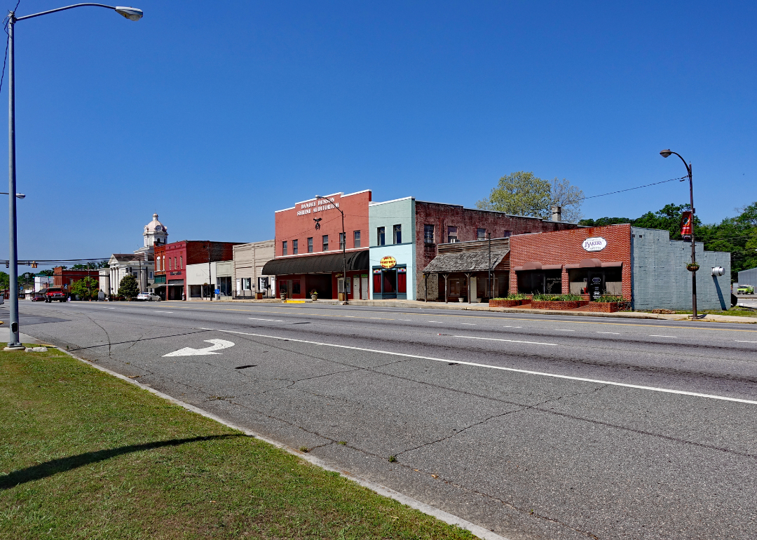
#31. Terrell County (tie)
– Life expectancy: 71.8 years
— 4.3 years lower than the state average
You may also like: Counties with the highest rates of high blood pressure in Georgia
About
Terrell County lies in southwest Georgia, where fertile fields have long defined its agricultural strength. Created in 1856, the county developed around farming, with Dawson as its seat and central hub of trade and education. Cotton, peanuts, and livestock remain vital parts of its economy, supported by a landscape of flat farmland and quiet rural roads.
Community life often revolves around schools, churches, and seasonal events that tie residents to both tradition and land. Dawson adds cultural and civic character, while smaller communities maintain the county’s rural rhythm. Terrell County reflects the enduring story of southwest Georgia—rooted in agriculture, close ties, and a steady way of living.
Where is Terrell County?
Terrell County is located in southwest Georgia, about 35 miles northwest of Albany and 75 miles south of Columbus. It is bordered by Webster County to the north, Lee to the east, Dougherty to the southeast, Calhoun to the southwest, and Randolph to the west. The county’s setting is largely flat farmland with stretches of pine forest and small waterways running through it.
Positioned in Georgia’s agricultural belt, Terrell County sits near major routes connecting Albany with other parts of the region. Its location ties it closely to surrounding farming communities while keeping it within reach of the larger trade and cultural centers of southwest Georgia.
#30. Chattooga County (tie)
– Life expectancy: 71.8 years
— 4.3 years lower than the state average
About
Chattooga County sits in the northwestern corner of Georgia, marked by the Appalachian foothills and valleys that give it a rugged and scenic backdrop. Established in 1838, it centers around Summerville, the county seat, while smaller towns and rural communities spread across its rolling landscape. The Chattooga River and surrounding mountains shape not only the land but also the recreational life of the county.
Music and tradition run deep here, with folk culture and local festivals bringing neighbors together. Mills, farms, and family businesses have long supported the economy, while schools and churches remain the heart of community identity. Chattooga County holds a balance of mountain heritage and small-town resilience that makes it distinct within northwest Georgia.
Where is Chattooga County?
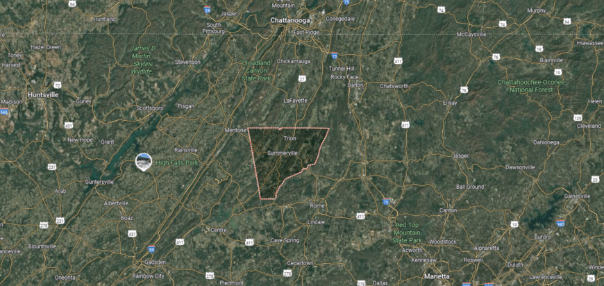
Chattooga County is in the northwestern corner of Georgia, about 90 miles northwest of Atlanta and 50 miles south of Chattanooga, Tennessee. It is bordered by Walker County to the north, Floyd to the south, Gordon to the east, and Alabama’s Cherokee County to the west. The terrain includes sections of the Appalachian foothills, with valleys cut by the Chattooga River and its tributaries.
Its position along the Georgia–Alabama line places the county within easy reach of both Rome, Georgia, and Chattanooga, Tennessee. The mix of mountain ridges, fertile valleys, and cross-state routes gives Chattooga County a distinctive setting tied to both natural scenery and regional connections.
#29. Screven County (tie)
– Life expectancy: 71.8 years
— 4.3 years lower than the state average
About
Screven County, on Georgia’s eastern edge, is anchored by the Savannah River, which has long shaped its history and economy. Founded in 1793, it is one of Georgia’s older counties, with Sylvania as its county seat. The fertile river valley supported farming and trade, while historic battle sites and cemeteries preserve reminders of its role in the state’s early and Civil War eras.
Today, community life blends those historic roots with a strong agricultural base of cotton, peanuts, and timber. Residents gather at festivals, schools, and local churches that continue to tie people together across rural communities. With its deep history and enduring river landscape, Screven County reflects both Georgia’s past and the steady traditions of its present.
Where is Screven County?
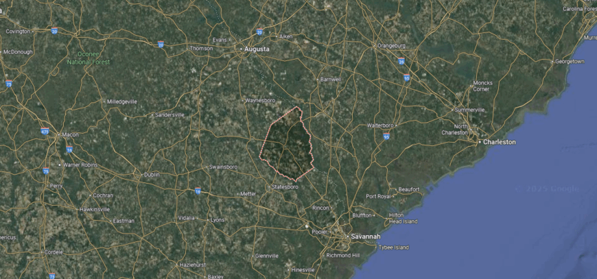
Screven County is located in eastern Georgia, about 60 miles north of Savannah and 80 miles south of Augusta. It is bordered by Burke County to the north, Jenkins to the west, Effingham and Bulloch to the south, and Allendale and Hampton counties in South Carolina to the east, with the Savannah River forming much of that boundary. The landscape is a blend of farmland, pine woods, and river lowlands.
Its position along the Savannah River places Screven County at a natural crossroads between Georgia’s coastal plain and South Carolina’s low country. The mix of agricultural land, waterways, and small towns reflects both its rural heritage and its role as a connector between inland Georgia and the coastal region.
#28. Wayne County
– Life expectancy: 71.7 years
— 4.4 years lower than the state average
About
Wayne County is known for its strong community ties, where local gatherings, high school sports, and annual events in Jesup bring residents together. Established in 1803, the county has grown around its courthouse square and town centers that serve as focal points for civic and social life. Timber and agriculture remain important to the economy, supported by the county’s location near major transportation routes in southeast Georgia.
The Altamaha River and surrounding pine forests add natural spaces for fishing, hunting, and outdoor recreation. Community pride is expressed through traditions that highlight the county’s heritage and rural character. Wayne County continues to sustain a steady way of life where work, land, and local connection shape its identity.
Where is Wayne County?
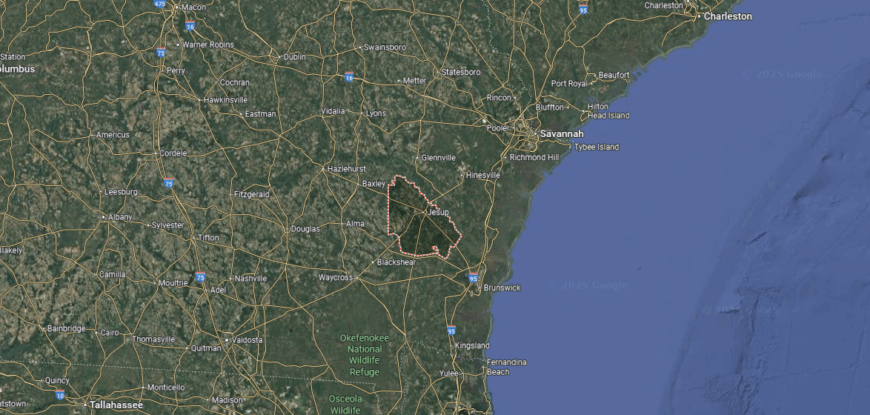
Wayne County is located in southeastern Georgia, about 65 miles southwest of Savannah and 40 miles northwest of Brunswick. It shares borders with Long and Liberty counties to the northeast, Appling to the west, Pierce to the south, and Glynn to the southeast. The county is characterized by pine forests, farmland, and access to the Altamaha River, which runs along its northern edge.
Jesup is the largest community and a central hub for business and transportation, with rail and highway routes passing through the area. Other towns, including Odum and Screven, reflect the county’s small-town setting, while the nearby river and woodlands provide opportunities for fishing, hunting, and outdoor recreation.
#27. Bibb County (tie)
– Life expectancy: 71.4 years
— 4.7 years lower than the state average
About
Bibb County, created in 1822, spans about 255 square miles in central Georgia and serves as a regional hub for business, education, and healthcare. Its county seat, Macon, has long been a center for commerce and industry, with transportation links by rail and interstate highways supporting economic growth. The Ocmulgee River flows through the area, shaping development and providing access to historic and recreational sites.
The county is equally recognized for its cultural contributions, from the Allman Brothers’ music legacy to the annual Cherry Blossom Festival that draws visitors each spring. Institutions like Mercer University and local museums add educational and artistic depth to community life. With its mix of economic strength and cultural presence, Bibb County plays a central role in Georgia’s middle region.
Where is Bibb County?
Bibb County is located in central Georgia, about 85 miles south of Atlanta. It is bordered by Monroe County to the north, Jones to the northeast, Twiggs to the east, Houston to the south, and Crawford to the west. The Ocmulgee River runs through the area, shaping much of the county’s landscape and supporting both transportation and settlement.
Macon occupies much of the county and serves as a regional center for culture, commerce, and higher education. Its location along major highways and rail lines has made Bibb County an important hub in central Georgia, while nearby rivers and forests provide balance between urban development and natural surroundings.
#26. Dougherty County (tie)
– Life expectancy: 71.4 years
— 4.7 years lower than the state average
You may also like: Counties with the highest STI rates in Georgia
About
Dougherty County lies in southwest Georgia along the Flint River, where wetlands, pine forests, and farmland define much of its geography. Established in 1853, the county grew around Albany, its largest city and seat, which became a vital river port and later a hub for rail, commerce, and education. Agriculture, including peanuts and pecans, has remained central to the local economy, alongside healthcare and manufacturing.
Albany also developed a strong cultural presence, known for its role in the civil rights movement and as the birthplace of musician Ray Charles. The community supports festivals, local arts, and historical preservation that reflect both resilience and pride. Dougherty County continues to balance its natural landscapes with its civic and cultural importance in southwest Georgia.
Where is Dougherty County?
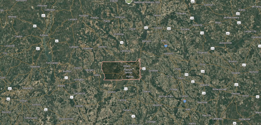
Dougherty County is located in southwest Georgia, about 90 miles south of Columbus and roughly 180 miles south of Atlanta. It is bordered by Lee County to the north, Worth to the northeast, Mitchell to the west, Calhoun to the northwest, and Baker and Terrell counties nearby, with the Flint River running through the region. The county’s landscape features level farmland, woodlands, and riverbottom areas that have long supported agriculture.
Albany is the largest city in the county and a regional center for education, healthcare, and commerce. Surrounding communities contribute to the area’s agricultural economy, while the Flint River and nearby recreational spaces connect Dougherty County to the natural environment of southwest Georgia.
#25. Evans County (tie)
– Life expectancy: 71.4 years
— 4.7 years lower than the state average
About
Evans County centers around the small-town community of Claxton, a place often recognized for its local gatherings and its long-standing reputation as the “Fruitcake Capital of the World.” Created in 1914, it is one of Georgia’s newer counties, covering just over 180 square miles. Agriculture remains a key part of the local economy, with crops and poultry farming supporting both residents and regional markets.
The county’s identity is shaped by its civic organizations, schools, and annual events that bring people together in a shared sense of place. The Ogeechee River adds opportunities for fishing, boating, and outdoor enjoyment, while the farmland surrounding the towns reflects its rural foundation. Evans County represents a community-oriented corner of southeast Georgia, where heritage and everyday life are closely connected.
Where is Evans County?
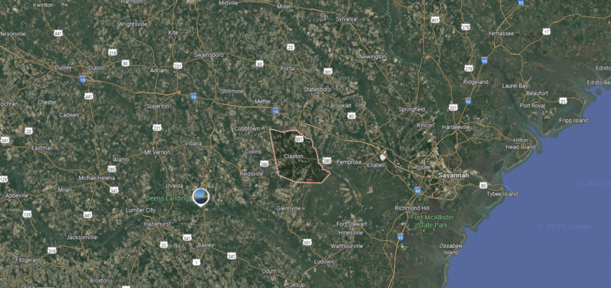
Evans County is located in southeastern Georgia, about 60 miles west of Savannah and 90 miles north of the Georgia–Florida line. It is bordered by Bulloch County to the north, Tattnall to the south and west, and Candler and Bryan counties nearby. The county covers mostly flat to gently rolling terrain, with farmland, pine forests, and portions of the Canoochee River running through it.
Claxton is the central community and the county’s largest town, positioned along U.S. Highway 280. Smaller communities such as Daisy, Bellville, and Hagan contribute to its local character, while the county’s location provides access to both inland agricultural areas and the Georgia coast.
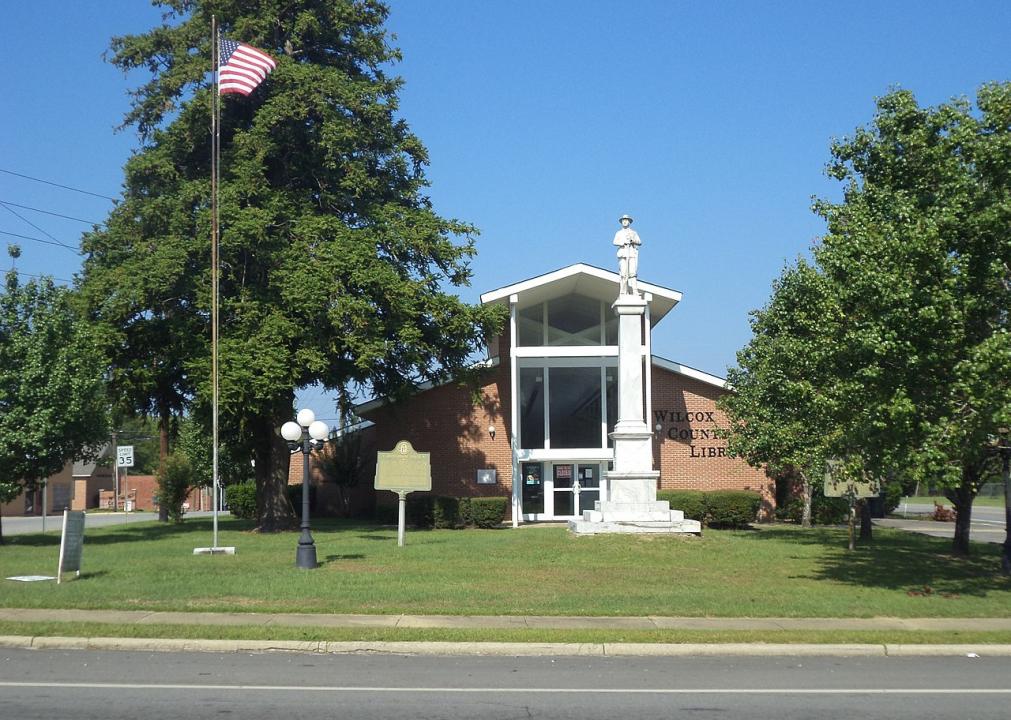
#24. Wilcox County (tie)
– Life expectancy: 71.3 years
— 4.8 years lower than the state average
About
Wilcox County is closely tied to the Ocmulgee River, which flows along its edge and has long supported farming, trade, and transportation in this south-central Georgia community. Established in 1857 and anchored by the county seat of Abbeville, the area spans about 380 square miles and developed around cotton, timber, and other agricultural activity.
Today, Wilcox County’s towns maintain a rural rhythm shaped by family farms, schools, and local traditions. Hunting, fishing, and outdoor activities remain popular, reflecting the county’s connection to its natural landscape. With deep historical roots and a steady reliance on the land, Wilcox stands as a clear example of Georgia’s agricultural heritage.
Where is Wilcox County?
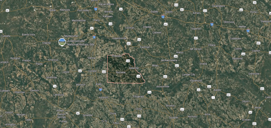
Wilcox County is located in south-central Georgia, roughly 60 miles south of Macon and about 125 miles from Atlanta. It borders Dodge and Pulaski counties to the north, Telfair to the east, Ben Hill and Turner to the south, and Crisp and Dooly counties to the west. The county’s setting features farmland, pine woods, and stretches of the Ocmulgee River along its edge.
The community of Abbeville is centrally placed within the county, with towns such as Rochelle, Seville, and Pitts nearby. Agriculture, especially row crops and timber, remains a key part of the local economy, while the rural surroundings reflect the county’s traditional south Georgia character.
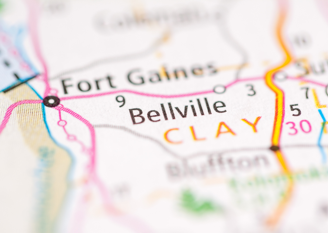
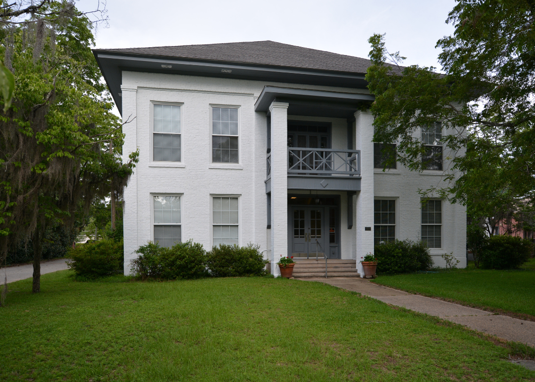
#23. Clay County (tie)
– Life expectancy: 71.3 years
— 4.8 years lower than the state average
About
Community life in Clay County is centered around its small towns, churches, and schools, where neighbors know one another and local gatherings carry forward long-standing traditions. Fort Gaines, the county seat, remains the focal point, with historic buildings and a courthouse square that reflect its 1854 founding.
The county spans about 217 square miles along the Chattahoochee River, giving residents access to outdoor activities such as fishing, boating, and hunting. Agriculture and forestry have historically supported the economy, while the surrounding landscapes provide both livelihood and a sense of place. Clay County represents a quiet corner of southwest Georgia where heritage and community are at the heart of daily life.
Where is Clay County?
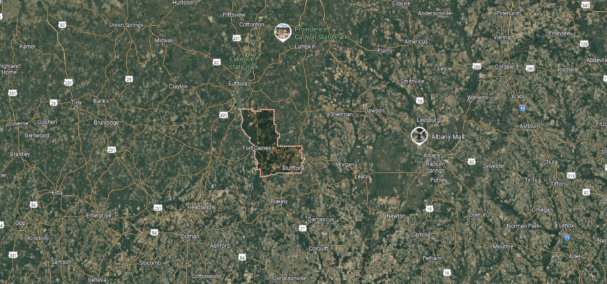
Clay County is located in southwest Georgia along the Alabama state line, with the Chattahoochee River forming much of its western boundary. It sits about 60 miles west of Albany and is bordered by Quitman County to the north, Randolph to the east, Calhoun to the southeast, and Henry County, Alabama, to the southwest. The area features rolling farmland, forested tracts, and access to Lake Walter F. George, a major reservoir on the Chattahoochee.
Fort Gaines is the main community, positioned on the river and connected by U.S. Highway 82. Smaller rural settlements are scattered across the county, which has long been rooted in agriculture and benefits from its riverfront setting for recreation and transport.
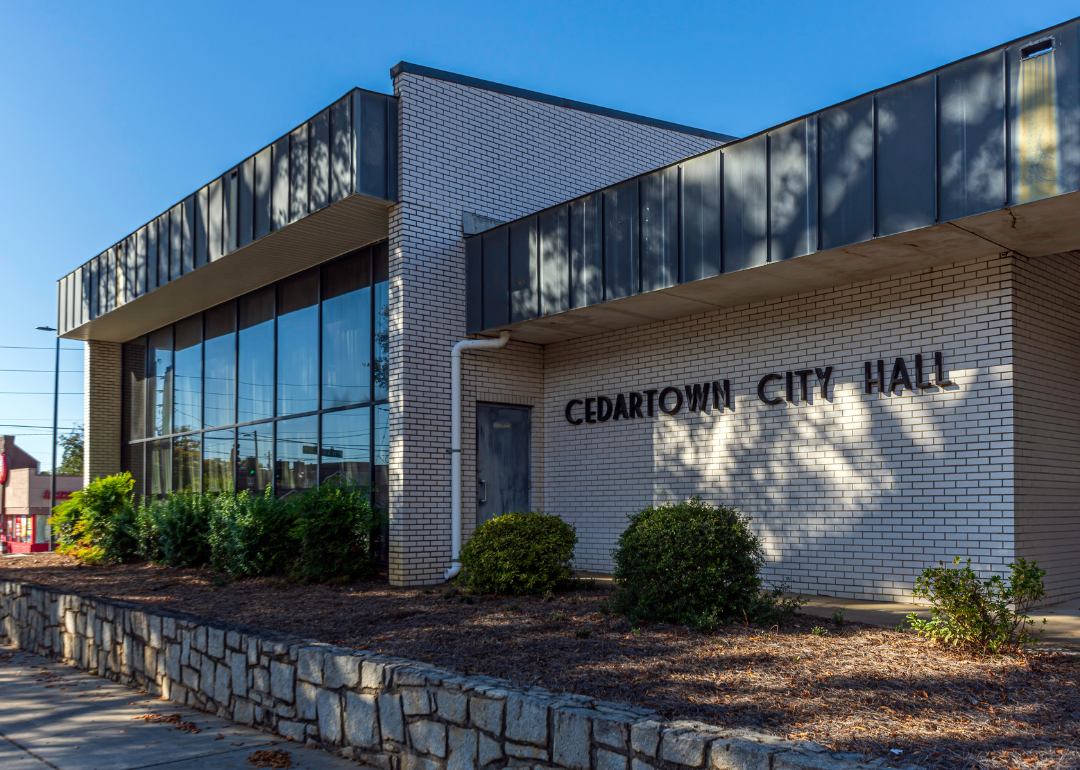
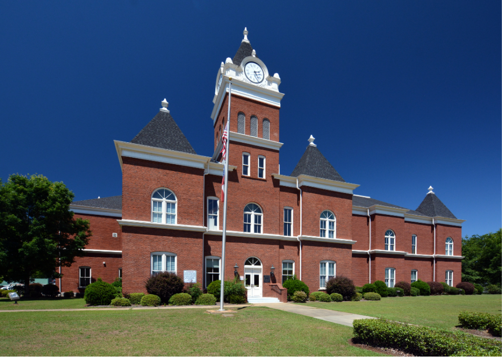
#22. Polk County (tie)
– Life expectancy: 71.3 years
— 4.8 years lower than the state average
About
Polk County, located in northwest Georgia, is shaped by rolling hills, woodlands, and the scenic backdrop of the Appalachian foothills. Established in 1851 and named for President James K. Polk, the county spans over 310 square miles with Cedartown as its seat. The Silver Comet Trail, a popular rails-to-trails path, runs through the area and highlights its ties to both nature and regional transportation history.
Agriculture and manufacturing have long supported the local economy, while the community centers around small-town life, schools, and civic traditions. Outdoor opportunities are abundant, from hiking and cycling to exploring local waterways and parks. Polk County reflects a balance of natural beauty, working landscapes, and a community spirit that remains central to its identity.
Where is Polk County?
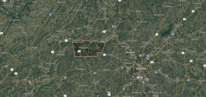
Polk County is located in northwestern Georgia along the Alabama state line, about 50 miles west of Atlanta. It is bordered by Floyd County to the northwest, Bartow and Paulding to the northeast, Haralson to the south, and Cleburne County, Alabama, to the west. The Tallapoosa River and ridges of the Appalachian foothills shape much of its terrain.
Cedartown, the county seat, anchors the area, while Rockmart and Aragon provide additional centers of community life. Its location along U.S. Highway 278 and near Interstate 20 places Polk County within easy reach of both Rome and metro Atlanta, while its farmland and wooded hills maintain a strong rural character tied to Georgia’s northwest region.
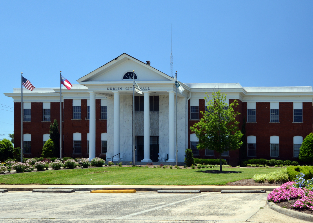
#21. Laurens County (tie)
– Life expectancy: 71.2 years
— 4.9 years lower than the state average
You may also like: Cities with the most expensive homes in Georgia
About
Laurens County, established in 1807 and named for Revolutionary War figure Colonel John Laurens, covers more than 800 square miles in central Georgia. The county seat, Dublin, grew as a river and rail town, serving as a hub of trade and transportation in the region. Its history is marked by agriculture, especially cotton, and by a notable cultural legacy that includes being the site where Dr. Martin Luther King Jr. delivered his first public speech as a teenager.
Modern Laurens County blends its historical roots with ongoing development in healthcare, manufacturing, and small business. Residents gather at community events, parks, and local institutions that sustain a shared sense of tradition. With its historic milestones and balanced growth, the county represents a significant piece of Georgia’s past and present.
Where is Laurens County?
Laurens County is located in central Georgia, about 50 miles southeast of Macon and roughly 150 miles from Atlanta. It shares borders with Wilkinson and Johnson counties to the north, Treutlen and Emanuel to the east, Montgomery and Wheeler to the south, and Dodge, Bleckley, and Twiggs counties to the west. The Oconee River runs along its western edge, with farmland, pine forests, and small lakes spread across the county.
Dublin, positioned near the center, is the largest community and a regional hub for commerce, healthcare, and education. Surrounding towns such as Dexter, Rentz, and Dudley highlight the county’s rural setting, while major highways provide connections to both Middle and South Georgia.
#20. Twiggs County (tie)
– Life expectancy: 71.2 years
— 4.9 years lower than the state average
About
Community gatherings, church events, and local traditions are central to life in Twiggs County, a rural area in central Georgia where residents maintain close ties across generations. Jeffersonville serves as the county seat, anchoring civic life and providing a focal point for education, commerce, and community events.
Created in 1809, the county covers about 360 square miles of farmland and timberland, with agriculture and forestry continuing to support its economy. The Ocmulgee River marks part of its landscape, offering opportunities for fishing and outdoor activity. Twiggs County reflects a steady way of life shaped by its natural setting, its historic roots, and the enduring connections of its people.
Where is Twiggs County?
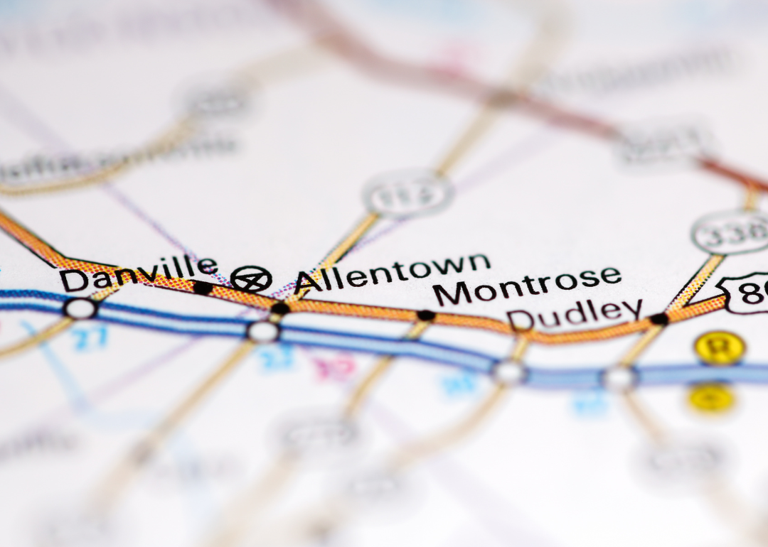
Twiggs County sits in central Georgia, about 15 miles southeast of Macon and roughly 100 miles south of Atlanta. It is bordered by Bibb County to the northwest, Wilkinson to the east, Bleckley to the south, and Jones to the north. The Ocmulgee River runs along its western side, and much of the county is covered with pine forests, farmland, and rural communities.
Jeffersonville is located near the center and functions as the main town, with smaller settlements such as Danville and Allentown nearby. The county’s position along Interstate 16 connects it to both Macon and Savannah, while its setting in Georgia’s fall line region reflects a blend of agricultural lands and timber resources.
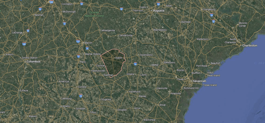
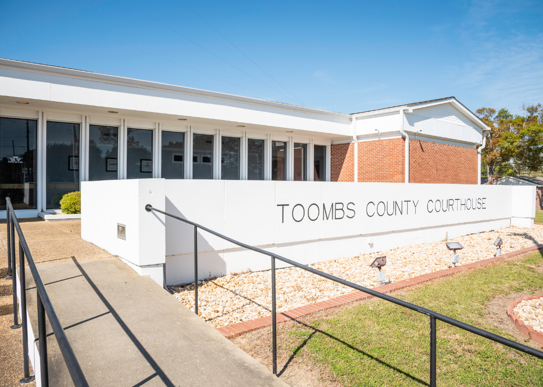
#19. Toombs County (tie)
– Life expectancy: 71.2 years
— 4.9 years lower than the state average
About
Toombs County is widely recognized for the town of Vidalia, home to the state’s famous sweet onions that have become a defining symbol of the region. Created in 1905, the county spans more than 360 square miles in southeast Georgia, with Lyons serving as the county seat. Its agricultural base, centered on onions, cotton, and other crops, continues to drive the local economy.
The community highlights its heritage through the annual Vidalia Onion Festival, which draws visitors to celebrate local farming traditions and regional pride. Beyond agriculture, manufacturing and small businesses contribute to its economy, while schools and civic organizations support community life. Toombs County blends its agricultural identity with a sense of tradition, making it an important part of Georgia’s farming landscape.
Where is Toombs County?
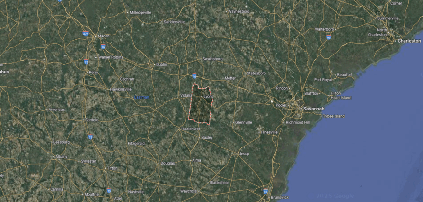
Toombs County is located in southeastern Georgia, about 90 miles west of Savannah and 60 miles northwest of Brunswick. It is bordered by Emanuel and Johnson counties to the north, Montgomery to the west, Appling to the south, and Tattnall and Treutlen counties to the east. The Ohoopee and Altamaha Rivers run along portions of its boundary, shaping the county’s farmland and forested areas.
Vidalia, noted for its association with the famous sweet onion, is the largest community, while Lyons also serves as a central town within the county. The area sits within Georgia’s coastal plain and maintains close connections to regional agriculture and transportation routes linking it to both coastal and inland markets.
#18. Meriwether County (tie)
– Life expectancy: 71.1 years
— 5.0 years lower than the state average
About
Meriwether County, established in 1827, developed around agriculture, textiles, and later manufacturing, industries that shaped its growth in west-central Georgia. The county covers about 505 square miles, with Greenville as the county seat, while nearby Warm Springs is historically known as the retreat of President Franklin D. Roosevelt. The presence of fertile farmland and natural springs has long supported both the economy and the daily lives of residents.
Community activities often revolve around historic sites, local schools, and cultural events that preserve the county’s character. Outdoor recreation is centered on F.D. Roosevelt State Park, the largest state park in Georgia, where hiking trails and scenic overlooks define the landscape. Meriwether County blends its working roots with a lasting connection to history and place.
Where is Meriwether County?
Meriwether County is located in west-central Georgia, about 50 miles southwest of Atlanta and 35 miles northwest of Columbus. It borders Coweta and Fayette counties to the north, Spalding and Upson to the east, Talbot to the south, and Troup and Harris counties to the west. The terrain is part of Georgia’s Piedmont region, with rolling hills, forests, and farmland spread throughout the county.
Greenville sits near the center and serves as the primary community, with other towns including Manchester, Lone Oak, and Warm Springs. The county’s location places it near the Pine Mountain range, where Warm Springs is noted for its historic connection to President Franklin D. Roosevelt and the Little White House.
#17. Hancock County (tie)
– Life expectancy: 71.1 years
— 5.0 years lower than the state average

About
Hancock County is anchored by Sparta, a town known for its collection of historic antebellum homes and courthouse square that reflect the county’s 1793 founding. Located in central Georgia and spanning about 479 square miles, the county developed through cotton production and agriculture, which shaped both its economy and its landscape.
Historical landmarks, churches, and civic gatherings continue to play a central role in community life. Residents take pride in preserving architecture and traditions that link modern life to the area’s early roots. With its blend of historic structures, rural surroundings, and community identity, Hancock County stands as a reminder of Georgia’s deep heritage.
Where is Hancock County?
Hancock County sits in east-central Georgia, about 40 miles northeast of Macon and 100 miles southeast of Atlanta. It is bordered by Baldwin County to the north, Washington to the east and southeast, Glascock and Warren to the northeast, and Putnam to the west. The Oconee River runs along its western edge, shaping farmland and forested valleys.
Sparta, the county seat, lies near the center and remains the largest community. Small rural towns and historic sites are scattered across the county, while Lake Sinclair touches its western boundary. Hancock’s placement links it closely to the agricultural and historic heart of middle Georgia while keeping it tied to both the Piedmont and river valley landscapes.
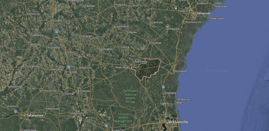
#16. Pierce County (tie)
– Life expectancy: 71.0 years
— 5.1 years lower than the state average
You may also like: Counties with the highest rates of strokes in Georgia
About
Pierce County, in southeastern Georgia, is defined by its flat pine forests, fertile fields, and the winding Satilla River that supports farming and outdoor life. Established in 1857, the county covers about 343 square miles, with Blackshear serving as the county seat and a central point for commerce and local government. Agriculture, particularly tobacco, cotton, and forestry, has long been the foundation of its economy.
Life in Pierce County reflects a strong rural character shaped by family farms, schools, and community gatherings. The area provides space for fishing, hunting, and recreation, while its towns maintain traditions that link residents to the land. Pierce County continues to represent a southeastern Georgia community where natural resources and local heritage guide daily living.
Where is Pierce County?
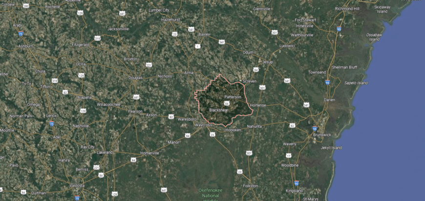
Pierce County is located in southeastern Georgia, about 80 miles southwest of Savannah and 20 miles north of Waycross. It is bordered by Appling County to the north, Wayne to the northeast, Brantley to the east, Ware to the south, and Bacon County to the west. The county’s setting features flat farmland, pine forests, and areas of wetlands linked to the Satilla River basin.
Blackshear, positioned near the center, is the largest community and a focal point for local activity. Additional towns such as Patterson and Offerman are spread across the county, while the surrounding landscape reflects its ties to agriculture and forestry. The county’s location places it within Georgia’s coastal plain, offering access to both rural countryside and nearby coastal regions.
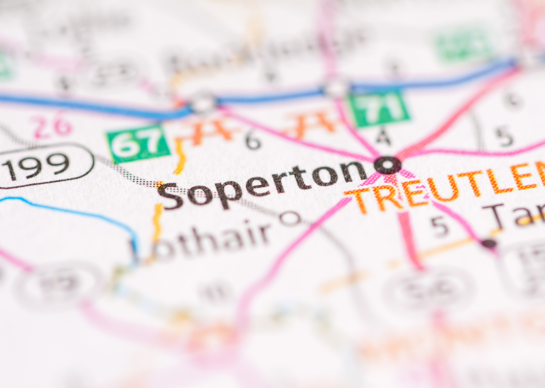
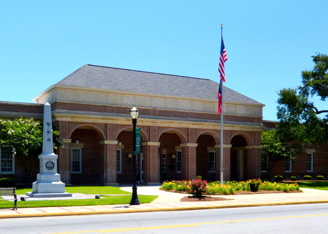
#15. Treutlen County (tie)
– Life expectancy: 71.0 years
— 5.1 years lower than the state average
About
Life in Treutlen County centers on its small-town connections, where neighbors gather for school events, church activities, and seasonal celebrations that highlight the area’s traditions. Soperton, the county seat, provides the hub for civic and cultural life, while surrounding communities remain closely tied through shared heritage and local pride.
Created in 1917 and spanning about 202 square miles in east-central Georgia, the county developed around agriculture, forestry, and small industry. The natural landscape of fields, woodlands, and streams continues to support both livelihood and recreation. Treutlen County offers a grounded way of life where community bonds and rural heritage remain at the forefront.
Where is Treutlen County?
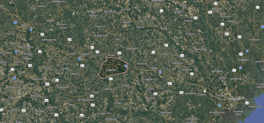
Treutlen County is located in east-central Georgia, about 60 miles southeast of Macon and 110 miles west of Savannah. It is bordered by Johnson and Emanuel counties to the north, Montgomery to the south, Toombs to the southeast, and Laurens to the west. The Ohoopee River flows along part of its eastern boundary, shaping the county’s largely rural landscape of farmland and pine forests.
Soperton is the main town at the county’s center, with smaller communities scattered across the area. Treutlen County’s position along major state routes connects it to both Middle Georgia and the coastal region, while its agricultural setting remains central to the county’s identity.
#14. Emanuel County
– Life expectancy: 70.9 years
— 5.2 years lower than the state average
Emanuel County was created in 1812 and named for Governor David Emanuel, making it one of Georgia’s older counties. Spanning more than 680 square miles in the east-central part of the state, it is anchored by the city of Swainsboro, a crossroads community that developed as a trading and transportation center. Agriculture, forestry, and manufacturing have been steady parts of the county’s economy, supported by the region’s farmland and timber resources.
Local traditions are highlighted through community events such as the Pine Tree Festival, which celebrates the county’s deep ties to forestry. Schools, churches, and civic organizations play a central role in everyday life, while outdoor opportunities along the Ohoopee River connect residents to the natural setting. Emanuel County represents a blend of heritage, resource-based work, and community traditions in rural Georgia.
Where is Emanuel County?
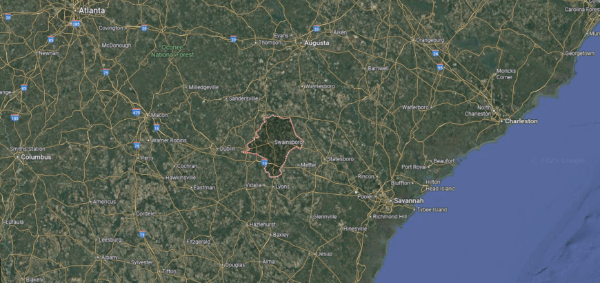
Emanuel County is located in east-central Georgia, about 90 miles northwest of Savannah and 60 miles southeast of Macon. It is bordered by Jenkins County to the north, Bulloch and Candler to the east, Toombs and Montgomery to the south, and Johnson and Treutlen counties to the west. The Ohoopee and Ogeechee Rivers cross parts of the county, contributing to its mix of farmland, pine forests, and rural landscapes.
Swainsboro, near the center, is the largest community and provides government and commercial services. Smaller towns such as Twin City, Adrian, and Stillmore are spread throughout the county, while its location ties it to both Georgia’s coastal plain and the agricultural areas of the state’s interior.
#13. Wilkinson County
– Life expectancy: 70.8 years
— 5.3 years lower than the state average

About
Wilkinson County stretches across more than 450 square miles in central Georgia, where pine forests, rolling hills, and winding creeks shape the landscape. Established in 1803 and named for General James Wilkinson, the county is centered around Irwinton, its seat of government. Agriculture and forestry have long been the foundation of its economy, with timber and farming sustaining local communities.
Residents connect through schools, churches, and county traditions that reflect a heritage rooted in rural life. The open countryside provides space for outdoor activities while preserving the area’s quiet character. Wilkinson County stands as a reflection of Georgia’s early history and its enduring reliance on the land.
Where is Wilkinson County?
Wilkinson County is located in central Georgia, about 30 miles southeast of Macon and roughly 110 miles from Atlanta. It is bordered by Baldwin County to the north, Washington and Johnson to the east, Laurens to the south, and Twiggs and Jones counties to the west. The county’s landscape includes rolling hills, pine forests, and stretches of the Oconee River forming part of its eastern boundary.
Irwinton lies near the center as a small community surrounded by towns such as Allentown, Toomsboro, and Ivey. Positioned within Georgia’s Piedmont region, Wilkinson County connects middle Georgia’s farmland with timber-rich areas and maintains a strong link to traditional rural life.
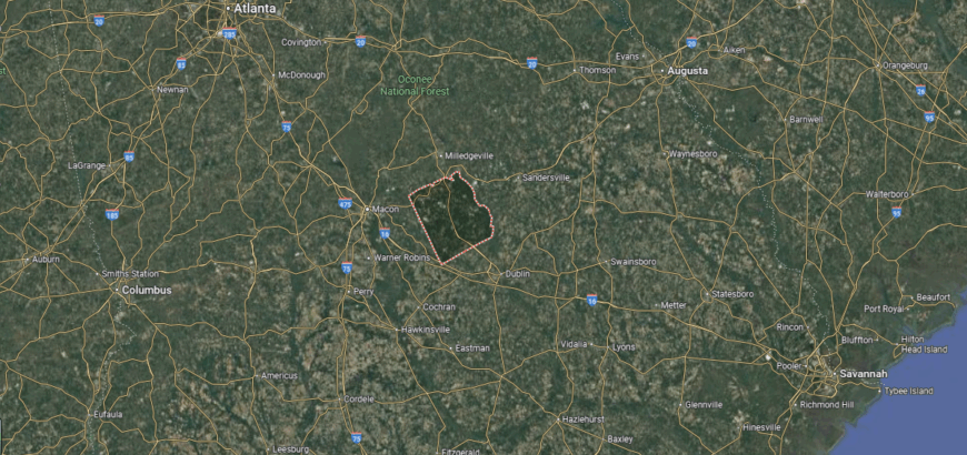
#12. Crisp County
– Life expectancy: 70.7 years
— 5.4 years lower than the state average
About
Crisp County is closely associated with Lake Blackshear, a reservoir on the Flint River that provides both recreation and hydroelectric power. Established in 1905 and spanning about 281 square miles in south-central Georgia, the county is centered around Cordele, a community often called the “Watermelon Capital of the World.” Agriculture, especially watermelons and cotton, has shaped much of the county’s economy and local traditions.
Residents take pride in annual events such as the Watermelon Festival, which draws visitors to celebrate one of the county’s most important crops. Beyond farming, industry and small businesses support the area, while the lake and surrounding lands create opportunities for fishing, boating, and outdoor gatherings. Crisp County’s identity is tied to its agricultural heritage, its landmark waters, and the community traditions that bring people together.
Where is Crisp County?
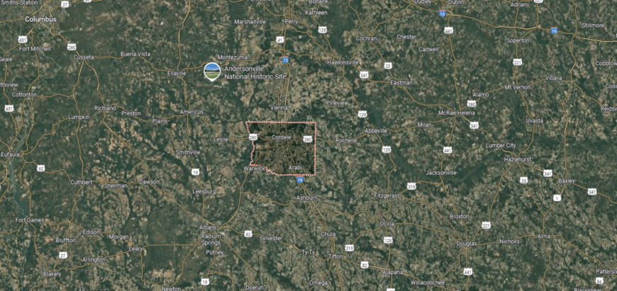
Crisp County is located in south-central Georgia, about 65 miles south of Macon and 40 miles north of Albany. It is bordered by Dooly County to the north, Wilcox to the east, Turner to the south, and Worth and Lee counties to the west. The landscape is defined by agricultural fields, pine forests, and the Flint River, which forms part of its western boundary.
Cordele, the largest community, is positioned near the center of the county along Interstate 75, making it a transportation hub in the region. Lake Blackshear, created by the Crisp County Power Dam on the Flint River, provides recreation and serves as a key feature of the county’s geography.
#11. Ware County
– Life expectancy: 70.4 years
— 5.7 years lower than the state average
You may also like: The biggest health care data breaches you should know about in Georgia
About
Ware County, the largest in Georgia by land area at over 900 square miles, is shaped by vast pine forests, rivers, and its connection to the Okefenokee Swamp. Established in 1824, the county grew around Waycross, its seat and largest city, which became a transportation hub through rail and trade. Forestry, agriculture, and manufacturing remain central to the local economy, supported by the county’s abundant natural resources.
The community gathers at local schools, churches, and events that highlight both tradition and regional pride. Outdoor activities such as boating, fishing, and exploring the Okefenokee National Wildlife Refuge connect residents and visitors to the county’s distinctive environment. Ware County stands as a landscape-driven community where natural beauty and resource-based livelihoods define daily life.
Where is Ware County?
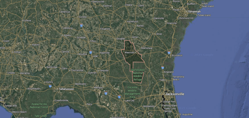
Ware County is located in southeastern Georgia, about 60 miles north of the Florida border and roughly 100 miles southwest of Savannah. It is the largest county in the state by land area, bordered by Coffee County to the northwest, Bacon and Pierce to the northeast, Brantley to the east, and Clinch and Charlton counties to the south, with the Satilla River flowing through parts of the county.
Waycross is the central city and serves as the primary hub for the area. Much of the county is covered by the Okefenokee Swamp, one of the most significant wetlands in the United States, providing both natural resources and recreational opportunities. The county’s location links Georgia’s coastal plain with the Florida borderlands.
#10. Upson County (tie)
– Life expectancy: 70.3 years
— 5.8 years lower than the state average

About
Upson County’s identity is strongly rooted in community life, where local schools, churches, and civic events continue to serve as gathering places. The county seat, Thomaston, reflects a legacy of mill villages and small-town tradition that has shaped daily routines and social ties. Established in 1824, the county encompasses roughly 326 square miles in west-central Georgia.
Cotton and textile production historically drove Upson’s economy, later joined by manufacturing and service industries that support the region today. Outdoor spaces along the Flint River and Sprewell Bluff provide recreation, fishing, and scenic views for residents. Upson County illustrates how a Georgia community maintains its sense of place through both its working roots and its enduring local connections.
Where is Upson County?

Upson County is located in west-central Georgia, about 60 miles south of Atlanta and 45 miles northeast of Columbus. It is bordered by Lamar and Monroe counties to the north, Crawford and Peach to the east, Taylor to the south, and Talbot and Meriwether counties to the west. The Flint River runs along its western edge, shaping much of the county’s landscape with valleys, bluffs, and farmland.
Thomaston, found near the center, is the largest community and a regional hub for business and industry. Smaller towns such as Yatesville and Lincoln Park are also part of the county, while the river and surrounding countryside tie Upson County to Georgia’s historic Piedmont and agricultural heartland.
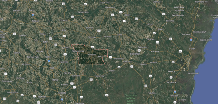
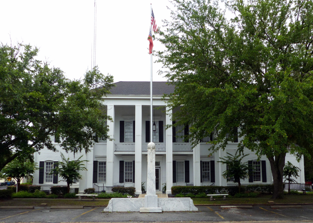
#9. Bacon County (tie)
– Life expectancy: 70.3 years
— 5.8 years lower than the state average
About
Bacon County was formed in 1914 and named in honor of U.S. Senator Augustus Octavius Bacon, making it one of Georgia’s newer counties. Covering about 286 square miles in the southeastern part of the state, it is anchored by Alma, which serves as the county seat and the center of civic life. Agriculture, especially tobacco and blueberries, has been a steady foundation for the local economy.
Life in Bacon County is closely tied to its farms and the traditions that have carried across generations. Alma is known for its annual Blueberry Festival, which celebrates the county’s role in blueberry production. With its agricultural base and community focus, Bacon County offers a clear example of how local heritage and land continue to shape daily life in rural Georgia.
Where is Bacon County?
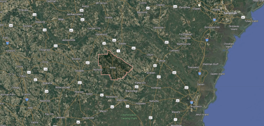
Bacon County is located in southeastern Georgia, about 100 miles southwest of Savannah and 60 miles northeast of the Florida line. It is bordered by Appling County to the north, Pierce to the east, Ware to the south, and Coffee and Jeff Davis counties to the west. The Satilla River flows along part of its southeastern edge, adding to the mix of farmland and pine flatwoods.
Alma, the county seat, stands near the center and serves as the hub for commerce, education, and civic life. Smaller rural communities are spread throughout the county, which is positioned within Georgia’s coastal plain. Its location provides access to surrounding agricultural counties while connecting south Georgia to the coastal region.
#8. Jefferson County (tie)
– Life expectancy: 70.2 years
— 5.9 years lower than the state average
About
Jefferson County, established in 1796, takes its name from Thomas Jefferson and has deep ties to the early history of Georgia. The county seat, Louisville, briefly served as the state capital and still preserves reminders of that era, including its historic courthouse square and the old state capitol building site. Spanning more than 525 square miles in east-central Georgia, the county has long relied on farming and timber as the backbone of its economy.
Daily life is centered around agriculture, small-town businesses, and gatherings that reflect traditions carried forward for generations. Historic landmarks and community events give residents a strong sense of identity, while the rural landscape connects them to the land. Jefferson County continues to embody the enduring heritage and community spirit of Georgia’s early heartland.
Where is Jefferson County?
Jefferson County is located in east-central Georgia, about 50 miles southwest of Augusta and 100 miles southeast of Atlanta. It is bordered by Richmond County to the northeast, Burke to the east, Emanuel to the south, Johnson to the southwest, Washington to the west, and Glascock County to the northwest. The Ogeechee and Ohoopee rivers run along parts of its boundaries, shaping farmland and forested areas across the county.
Louisville, situated near the center, is the largest community and has historic significance as a former state capital of Georgia. Other towns such as Wadley, Wrens, and Avera connect the county’s agricultural economy with regional markets. Its location between Augusta and Macon places Jefferson County within reach of both urban centers while maintaining its rural setting.
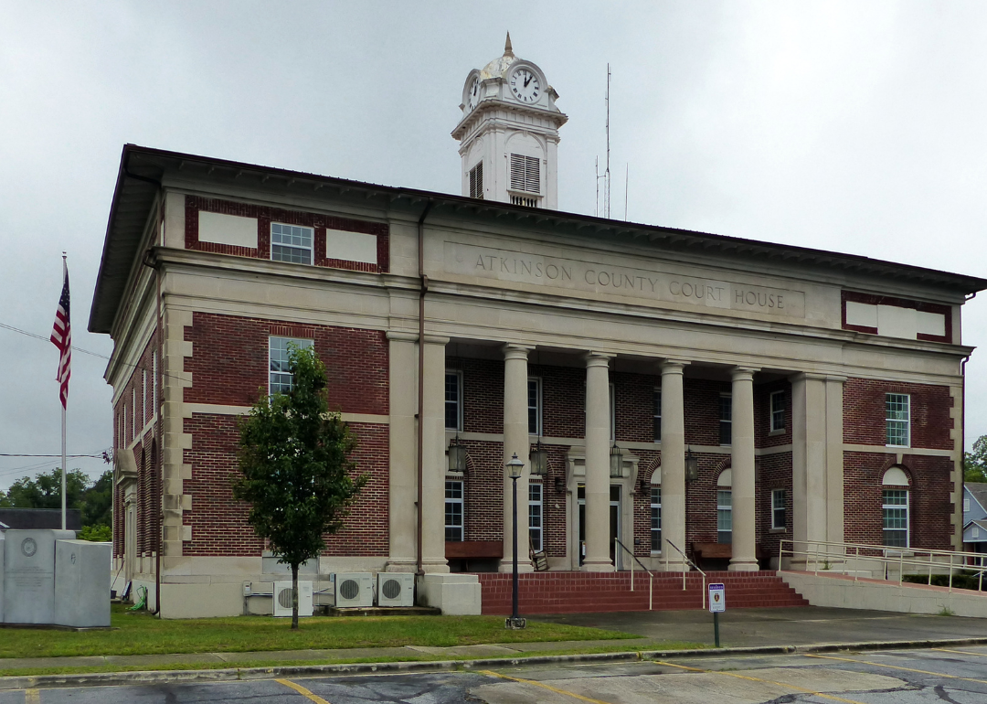
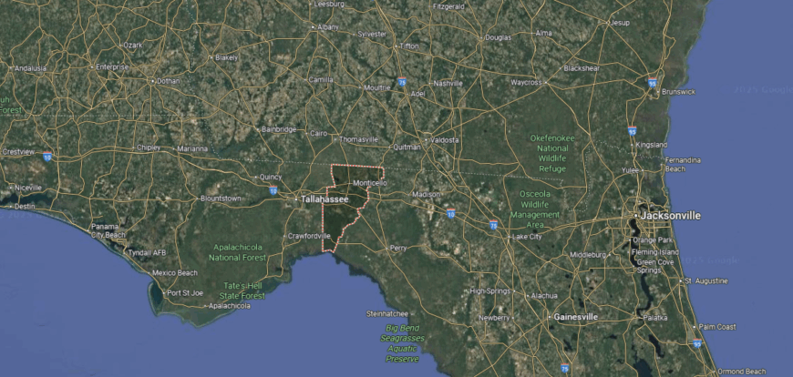
#7. Atkinson County (tie)
– Life expectancy: 70.2 years
— 5.9 years lower than the state average
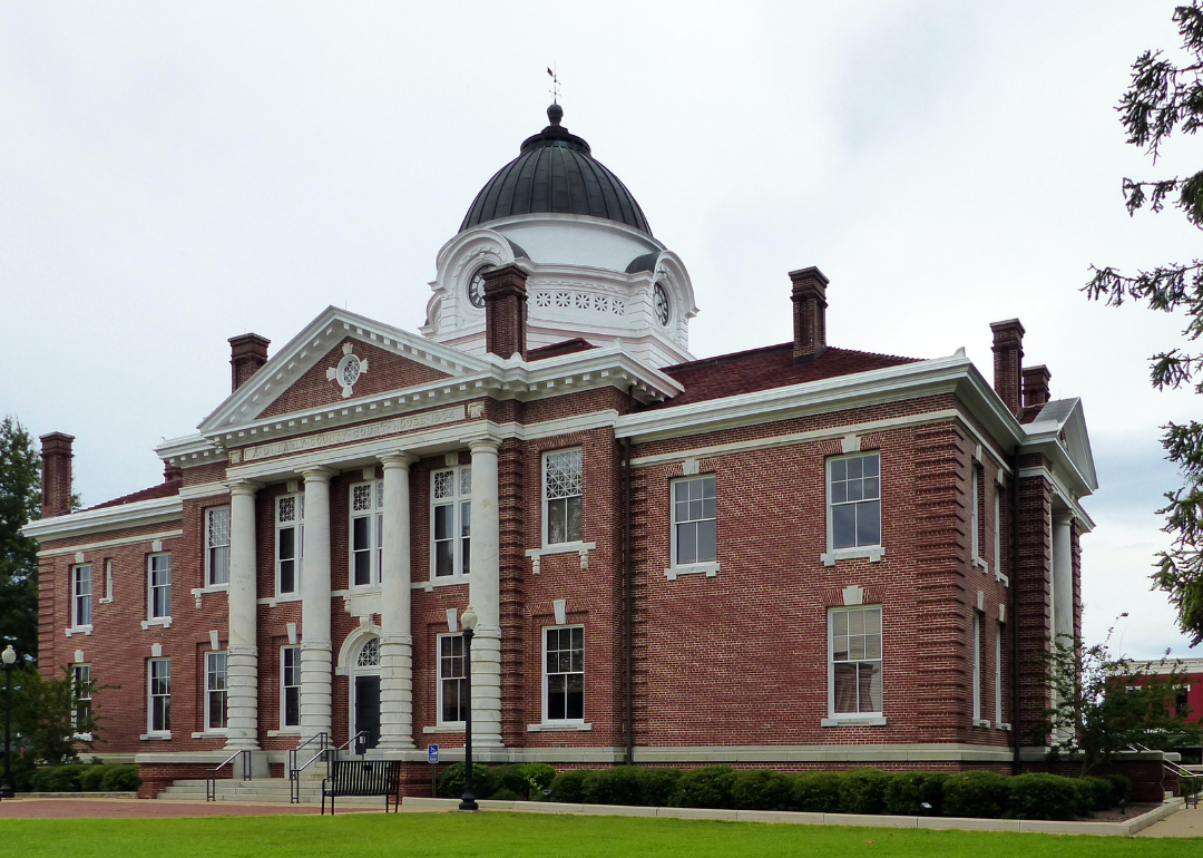
About
Atkinson County is shaped by its close-knit communities, where schools, churches, and local events form the center of everyday life. The county seat, Pearson, serves as the hub of civic and social activity, while nearby towns and rural areas reflect the county’s small-scale, family-oriented character.
Created in 1917 and covering about 345 square miles in south Georgia, the county has an economy rooted in agriculture, forestry, and related industries. The surrounding pine forests and farmland support both work and recreation, while traditions and local gatherings preserve its rural heritage. Atkinson County remains a place defined by its people, where community ties continue to guide the rhythm of life.
Where is Atkinson County?
Atkinson County is located in south-central Georgia, about 100 miles northwest of Jacksonville, Florida, and 75 miles southeast of Albany. It is bordered by Coffee County to the north, Ware to the east, Clinch to the south, and Berrien County to the west. The county’s landscape is made up of pine forests, farmland, and stretches of the Satilla and Alapaha rivers.
Pearson is the primary community, positioned near the center of the county, with Willacoochee as another notable town. Its location along U.S. Highway 82 provides access to nearby cities and connects Atkinson County to both the agricultural regions of south Georgia and the larger markets of coastal and southern states.
#6. Early County
– Life expectancy: 70.1 years
— 6.0 years lower than the state average
You may also like: How compensation compares between Georgia staff and travel nurses
About
Early County sits in the far southwest corner of Georgia, bordered by the Chattahoochee River and covered in farmland, pine forests, and stretches of open countryside. Created in 1818 as one of the state’s original counties from Creek Indian territory, it spans about 514 square miles with Blakely as its county seat. The land has long supported agriculture, particularly peanuts, cotton, and timber, which remain central to the local economy.
The county is also known for its historic sites, including Native American mounds and landmarks tied to its early settlement. Community life revolves around small-town traditions, school activities, and regional gatherings that reflect both heritage and connection to the land. Early County stands as a southwestern Georgia community where natural resources, history, and local ties continue to shape its identity.
Where is Early County?
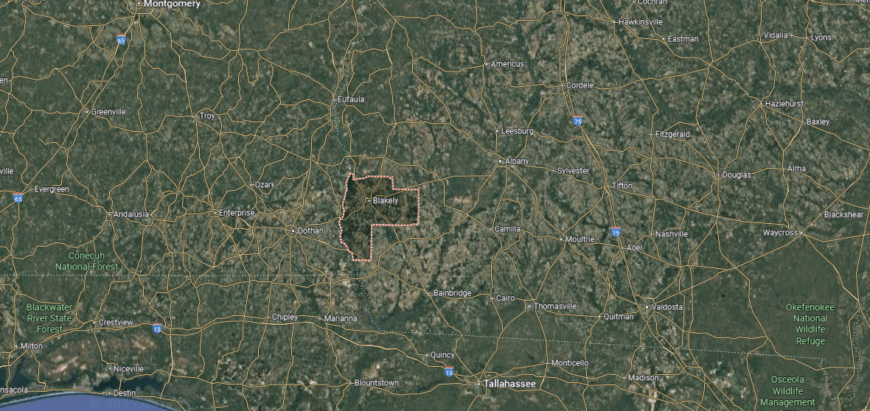
Early County is located in the southwest corner of Georgia, about 60 miles southwest of Albany and directly along the Alabama state line. It is bordered by Clay County to the north, Calhoun and Baker counties to the east, Miller to the south, and Houston and Henry counties in Alabama to the west, with the Chattahoochee River forming much of its western boundary. The county’s landscape features flat farmland, pine forests, and river bottoms that have long supported agriculture.
Blakely is the central community and the largest town in the county, with smaller communities such as Damascus and Jakin nearby. The county’s position along the Florida and Alabama borders makes it a gateway to neighboring states, while its fertile land ties it closely to farming and timber production in southwest Georgia.
#5. Clinch County
– Life expectancy: 69.8 years
— 6.3 years lower than the state average
About
Clinch County, created in 1850, covers more than 800 square miles in south Georgia, much of it made up of forests and wetlands tied to the Okefenokee Swamp. Homerville, the county seat, serves as the primary center of government and local commerce within this largely rural landscape. Forestry, agriculture, and natural resources have long supported the economy, with the swamp itself standing as both a landmark and a defining feature.
The county’s identity is shaped by its quiet communities, outdoor traditions, and the rhythms of working the land. Hunting, fishing, and exploring the vast wilderness remain central activities, connecting residents and visitors alike to the area’s environment. With its wide stretches of pine and waterways, Clinch County represents one of Georgia’s most naturally secluded regions, where heritage and landscape are closely tied.
Where is Clinch County?
Clinch County is located in southern Georgia along the state’s border with Florida. It is bordered by Echols County to the west, Ware to the east, Atkinson to the north, and Nassau and Baker counties in Florida to the south. Much of the county’s landscape is dominated by pine forests, wetlands, and the northern stretches of the Okefenokee Swamp.
Homerville is the main community at the county’s center, with smaller areas such as Argyle, Du Pont, and Fargo nearby. Its location near the Okefenokee makes it a gateway for outdoor activities like boating and wildlife viewing, while agriculture and timber remain central to the county’s rural economy.
#4. Candler County (tie)
– Life expectancy: 69.6 years
— 6.5 years lower than the state average
About
Candler County is often recognized for its community gatherings, where residents come together for events like the annual festival in Metter that highlights local pride and shared traditions. The county seat, Metter, serves as the center of education, commerce, and civic life, giving the area a small-town core that ties its rural communities together.
Established in 1914, the county spans about 249 square miles in southeast Georgia and has long relied on agriculture, including cotton, tobacco, and livestock farming. The surrounding farmland and pine forests provide both work and recreation, while historic structures and community institutions preserve its heritage. Candler County continues to embody a way of life defined by its people, traditions, and connection to the land.
Where is Candler County?
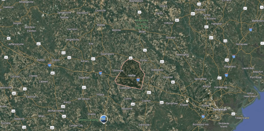
Candler County is located in southeastern Georgia, about 65 miles west of Savannah and 90 miles southeast of Macon. It is bordered by Emanuel County to the north, Bulloch to the east, Tattnall to the south, and Treutlen and Evans counties to the west. The county’s landscape features level farmland, pine woods, and sections of the Canoochee River.
Metter, positioned near the center, is the largest community and provides the main commercial and civic services. Other small towns and rural settlements dot the county, while its location along major highways connects it to both coastal Georgia and the agricultural regions inland.
#3. Ben Hill County (tie)
– Life expectancy: 69.6 years
— 6.5 years lower than the state average
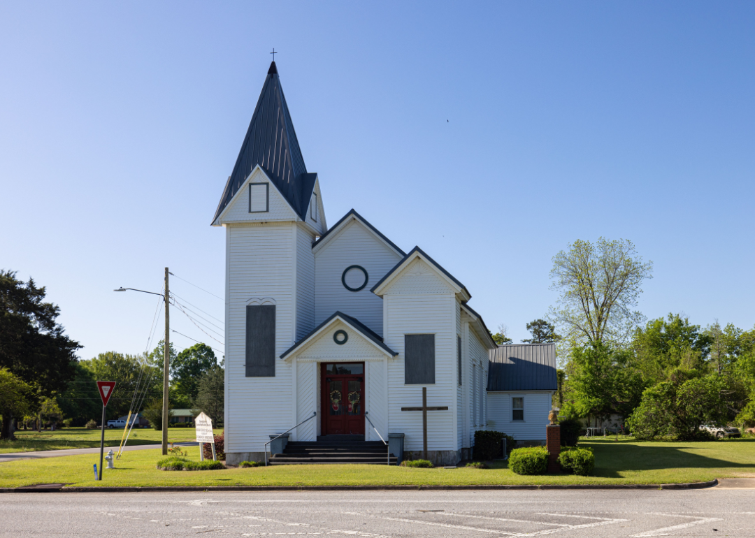
About
Ben Hill County was established in 1906 and named in honor of U.S. senator Benjamin Harvey Hill. Spanning about 255 square miles in south-central Georgia, the county is centered around Fitzgerald, a community originally founded as a settlement for Union and Confederate veterans after the Civil War. That unique origin gives the area a notable place in Georgia’s history, blending traditions from both sides of the conflict.
Agriculture and small industries continue to support the county’s economy, with farming and timber playing important roles in daily life. Fitzgerald has developed into the cultural hub, known for its historic architecture and the presence of a roaming colony of wild chickens that have become a local trademark. Ben Hill County reflects a distinctive history of reconciliation and a continued connection to land and community.
Where is Ben Hill County?
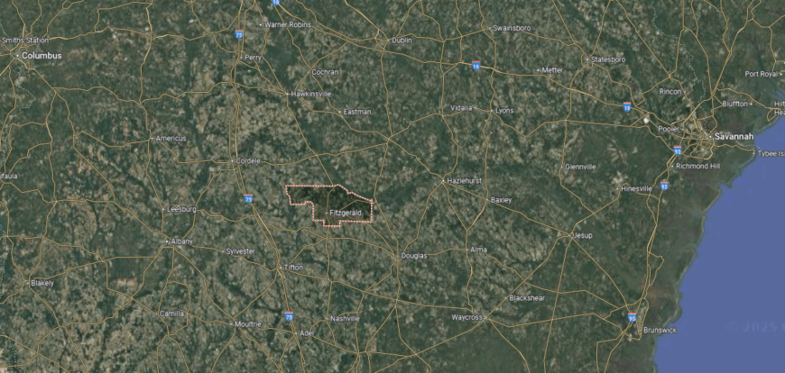
Ben Hill County is located in south-central Georgia, about 60 miles south of Macon and roughly 30 miles northeast of Tifton. It is bordered by Wilcox County to the north, Telfair to the northeast, Coffee to the southeast, Irwin to the south, and Turner to the west. The county’s landscape is largely agricultural, with farmland, pine forests, and portions of the Ocmulgee River along its northern boundary.
Fitzgerald is the largest community and a regional center that developed in the late 19th century as a settlement for Union and Confederate veterans. Surrounding communities such as Queensland and Ashton reflect the county’s rural character, while its location provides connections to nearby south Georgia counties and transportation routes through the region.
#2. Quitman County
– Life expectancy: 68.6 years
— 7.5 years lower than the state average
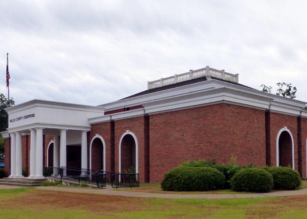
About
Quitman County sits along the western edge of Georgia, bordered by the waters of the Chattahoochee River and Lake Walter F. George. Created in 1858 and covering just under 162 square miles, it is one of the smallest counties in the state, with Georgetown serving as its county seat. The land supports farming and forestry, while the nearby lake and river have become central to outdoor recreation and local life.
Residents gather for community events, church activities, and outdoor traditions that connect them to both history and landscape. The county’s economy remains grounded in agriculture, but its riverside setting also draws visitors for fishing, boating, and camping. Quitman County maintains a quiet, close-knit character, shaped as much by its natural boundaries as by the people who call it home.
Where is Quitman County?
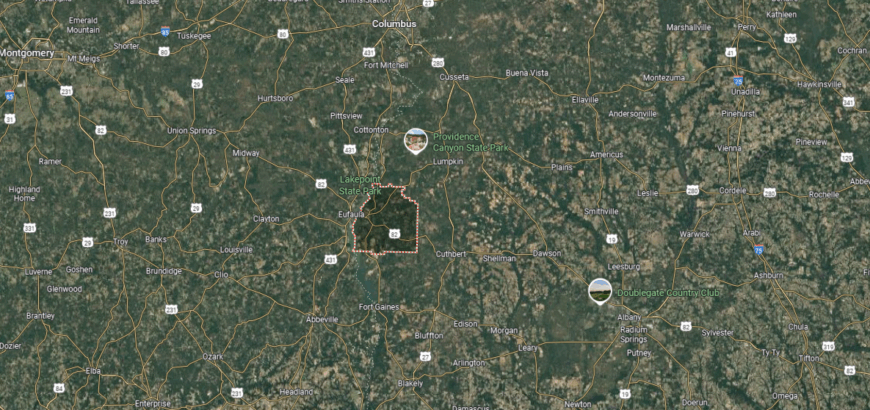
Quitman County is located in southwestern Georgia along the Chattahoochee River, directly bordering Alabama. It is one of the state’s smaller counties, situated about 65 miles south of Columbus and 55 miles northwest of Albany. The county shares boundaries with Stewart County to the north, Randolph to the east, Clay to the south, and Barbour County, Alabama, across the river.
Georgetown sits on the banks of the Chattahoochee and serves as the central community. The county’s location on Lake Walter F. George provides access to boating, fishing, and waterfront recreation, while the surrounding farmland and woodlands connect it to the agricultural character of southwest Georgia.
#1. Miller County
– Life expectancy: 67.7 years
— 8.4 years lower than the state average
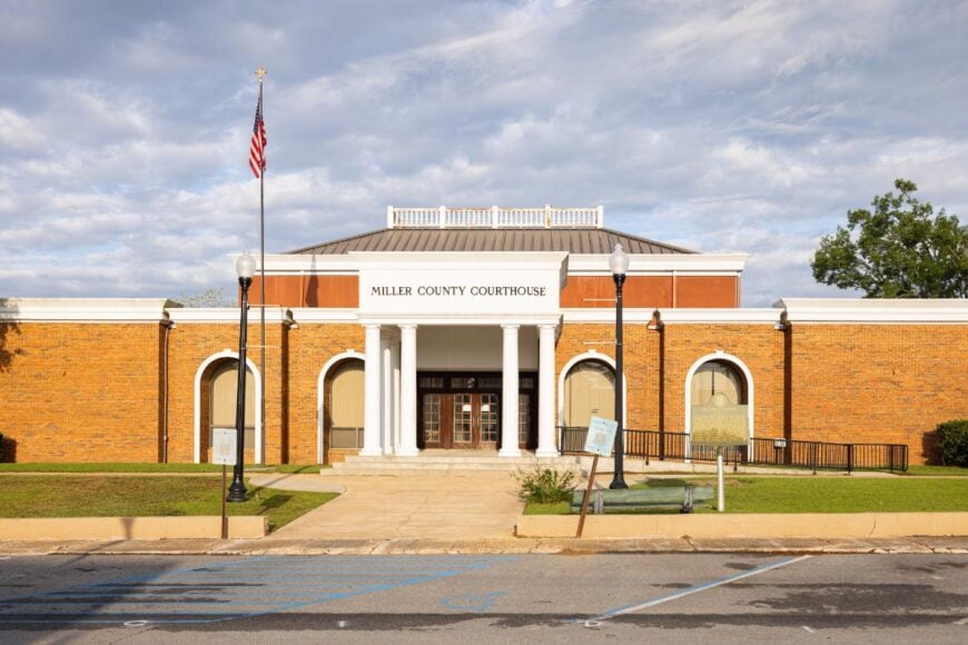
About
Miller County, founded in 1856 and named after Judge Andrew J. Miller, spans about 284 square miles in the southwest corner of Georgia. Its county seat, Colquitt, developed as a small hub for trade and government, and today still serves as the center of community life. Agriculture has always been the backbone here, with peanuts, cotton, and livestock shaping much of the local economy.
What sets Miller County apart is its cultural emphasis—Colquitt is home to Swamp Gravy, Georgia’s official folk-life play, which draws visitors and celebrates local stories on stage. Festivals and arts events provide a creative counterbalance to the county’s farming roots, strengthening community bonds. With its combination of history, agriculture, and cultural expression, Miller County reflects both tradition and creativity within rural Georgia.
Where is Miller County?
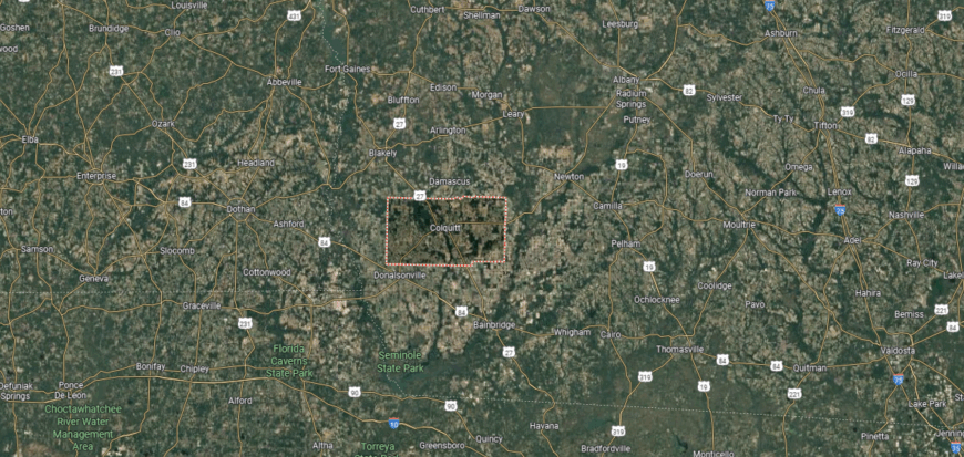
Miller County sits in the far southwest corner of Georgia, about 95 miles south of Columbus and 50 miles west of Albany. It is bordered by Early County to the west, Baker to the north, Decatur to the east, and Seminole County to the south. Much of its landscape is flat farmland and pine forest, with the Flint River nearby on the eastern side.
Colquitt, the county seat, lies near the center and serves as the largest community. Smaller rural settlements dot the countryside, where agriculture continues to dominate daily life. Its position near both the Alabama and Florida borders ties Miller County to the broader southwest Georgia region, giving it strong links to neighboring states and nearby farming centers.
This story features data reporting by Karim Noorani, writing by Kiersten Hickman, and is part of a series utilizing data automation across 49 states.
You may also like: How many people are receiving substance use treatment in Georgia
By Stacker