🔥 Would you like to save this?
Best counties to live in West Virginia – chosen from a variety of factors including median home values
More counties in the United States experienced population growth in the last year, according to the latest Census data, even as pandemic-related moving trends begin to normalize.
Counties in the South continued to experience growth, particularly in Florida, where 96% of its 67 counties gained new residents. Polk County, Florida, a suburb of Orlando, added the most, with 26,000 people moving there in 2023.
Meanwhile, counties in the Midwest and Northeast continued to lose population, but at slower rates than the year before. Some of the biggest losses were in counties home to large cities, including Cook County, Illinois (home of Chicago) and the boroughs of Brooklyn and Queens in New York.
Many counties are experiencing growth due to their job opportunities, education, or relatively affordable housing costs. Others are favored for their historic or well-designed downtowns or access to cultural opportunities.
Stacker compiled a list of the best counties to live in West Virginia using rankings from Niche. Niche ranks counties by various factors including public schools, educational attainment, cost of living, and housing.
Keep reading to see if your county made the list.
You may also like: Counties with the worst commutes in West Virginia

#27. Wirt County, West Virginia
– Overall Rank: Not ranked
– Population: 5,202
– Median household income: $52,776
– Median home value: $109,200 (85% own)
– Median rent: $490 (15% rent)
– Top public schools: Wirt County Middle School (grade B), Wirt County Primary Center (grade B minus), Wirt County High School (grade C)
– Top private schools:
– Top places: Elizabeth (grade C)
In order to come up with the very specific design ideas, we create most designs with the assistance of state-of-the-art AI interior design software. Also, assume links that take you off the site are affiliate links such as links to Amazon. this means we may earn a commission if you buy something.
About
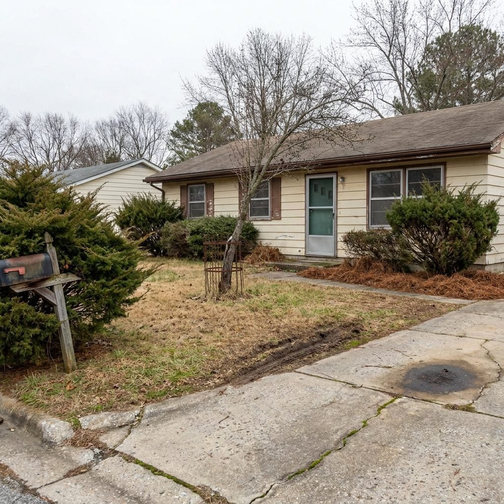
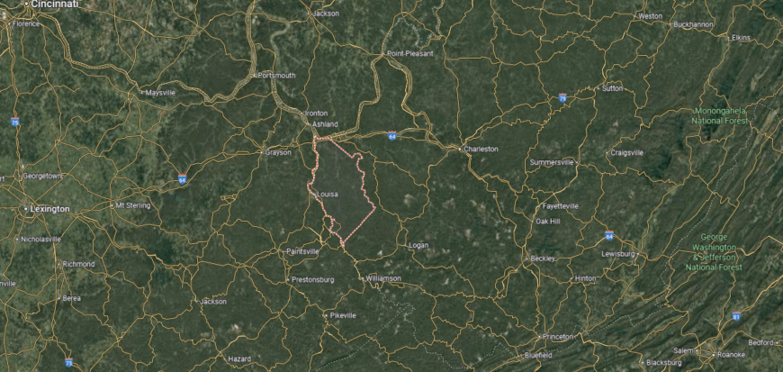
Wirt County, West Virginia lies within the rolling hills of the Little Kanawha River Valley, where forests and farmland define its quiet landscape. Its history is rooted in early settlement, timber, and oil, shaping small communities that remain closely tied to the land. Elizabeth, the county seat, serves as a center for local life and civic connection.
Community rhythms follow school events, church gatherings, and seasonal fairs that bring residents together. Outdoor opportunities like hunting, fishing, and exploring wooded trails keep traditions of rural living alive. Wirt County reflects a modest but enduring spirit, grounded in heritage and strengthened by close-knit community ties.
Where is Wirt County?
Wirt County is situated in western West Virginia, bordered by Wood County to the north and Ritchie County to the east. It is the smallest county in the state by land area, covering about 235 square miles of rolling hills and river valleys. Elizabeth, the county seat, lies along the Little Kanawha River near the county’s center.
Other communities include Palestine to the west and Newark to the north, both small settlements tied to the county’s rural character. Wirt County is positioned about 20 miles southeast of Parkersburg, providing access to larger urban services. Its location highlights a landscape of farms, woodlands, and river corridors typical of northwestern West Virginia.
#26. Wayne County, West Virginia
– Overall Rank: Not ranked
– Population: 38,933
– Median household income: $52,694
– Median home value: $114,200 (77% own)
– Median rent: $865 (23% rent)
– Top public schools: Buffalo Middle School (grade B+), Buffalo Elementary School (grade B), Dunlow Elementary School (grade B)
– Top private schools:
– Top places: Kenova (grade B), Lavalette (grade B), Ceredo (grade B minus)
About
Wayne County, West Virginia stretches along the state’s western edge, where the Ohio River and Appalachian hills shape both its geography and heritage. Its history is tied to river trade, timber, and the coal industry, which left lasting marks on its communities. The county seat, Wayne, along with nearby towns, reflects a blend of small-town life and historic character.
Residents gather for fairs, festivals, and school-centered events that strengthen community bonds. Outdoor life thrives in the region’s forests, rivers, and winding trails, offering both work and recreation. Wayne County carries forward a tradition of resilience, where heritage and landscape continue to guide its identity.
Where is Wayne County?
Wayne County lies in the westernmost tip of West Virginia, bordered by Kentucky to the west across the Big Sandy River and Ohio to the northwest across the Ohio River. It spans about 512 square miles, with terrain ranging from river valleys to Appalachian hills. Wayne, the county seat, is located near the center, about 15 miles southwest of Huntington.
Other communities include Kenova at the confluence of the Ohio and Big Sandy rivers, and Fort Gay along the Kentucky border. The county’s location places it within the Huntington–Ashland metropolitan area while still maintaining strong rural ties. Wayne County’s setting at the crossroads of three states gives it both regional significance and cultural diversity.
#25. Taylor County, West Virginia
– Overall Rank: Not ranked
– Population: 16,602
– Median household income: $52,946
– Median home value: $138,100 (80% own)
– Median rent: $702 (20% rent)
– Top public schools: West Taylor Elementary School (grade B+), Anna Jarvis Elementary School (grade C+), Taylor County Middle School (grade C)
– Top private schools:
– Top places: Grafton (grade B), Flemington (grade C+)
About
Taylor County, West Virginia rests in the north-central part of the state, where river valleys and wooded hills provide a backdrop for daily life. Its history is marked by the railroad, early industry, and the founding of Mother’s Day in the county seat of Grafton. Communities here reflect both historic pride and the steady rhythms of rural living.
Local traditions continue through festivals, church events, and civic gatherings that keep residents closely connected. Outdoor opportunities along the Tygart Valley River and surrounding hills highlight the county’s natural character. Taylor County stands as a place where history, community, and landscape remain woven into a lasting sense of place.
Where is Taylor County?
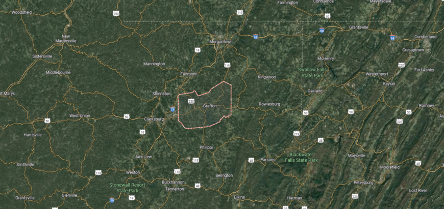
Taylor County is located in north-central West Virginia, bordered by Marion County to the northwest, Preston County to the east, and Barbour County to the south. It covers about 176 square miles, making it one of the smaller counties in the state. Grafton, the county seat, lies along the Tygart Valley River and serves as the county’s main community.
Other towns include Flemington to the west and Thornton in the northeastern section. The county sits roughly 20 miles southeast of Fairmont and about 25 miles south of Morgantown, linking it to larger regional centers. Taylor County’s position in the Appalachian foothills combines small-town life with access to major transportation routes in northern West Virginia.
#24. Preston County, West Virginia
– Overall Rank: Not ranked
– Population: 34,206
– Median household income: $60,136
– Median home value: $147,400 (81% own)
– Median rent: $738 (19% rent)
– Top public schools: Fellowsville Elementary School (grade B), Aurora Elementary School (grade C+), Bruceton School (grade C+)
– Top private schools:
– Top places: Kingwood (grade B), Brandonville (grade B minus), Rowlesburg (grade C)
About
Preston County, West Virginia lies in the state’s northern mountains, where high ridges, valleys, and winding rivers shape both work and recreation. Its heritage is tied to farming, coal, and timber, industries that long supported its small towns and rural communities. Kingwood, the county seat, anchors civic life while keeping ties to the county’s historic character.
Residents take pride in the annual Buckwheat Festival, a tradition that celebrates both agriculture and community spirit. Outdoor activities such as fishing, hunting, and hiking remain central to daily life, reflecting the county’s natural setting. Preston County embodies a blend of rugged landscape, cultural tradition, and enduring community strength.
Where is Preston County?
Preston County is in the northeastern part of West Virginia, bordered by Pennsylvania to the north and Maryland to the east. It spans about 650 square miles, much of it covered by Appalachian highlands and river valleys. Kingwood, the county seat, is located near the center, about 20 miles southeast of Morgantown.
Other communities include Terra Alta in the eastern mountains, Masontown to the west, and Bruceton Mills close to the Pennsylvania border. The Cheat River runs through the county, adding to its geographic character. Preston County’s position places it within the Allegheny Mountains, blending rural communities with outdoor recreation and cross-border connections.
#23. Nicholas County, West Virginia
– Overall Rank: Not ranked
– Population: 24,624
– Median household income: $48,826
– Median home value: $110,600 (80% own)
– Median rent: $664 (20% rent)
– Top public schools: Mt. Nebo Elementary School (grade B), Panther Creek Elementary School (grade B), Mt. Lookout Elementary School (grade B)
– Top private schools: New Life Christian Academy (grade C+)
– Top places: Summersville (grade B), Craigsville (grade C), Richwood (grade C)
You may also like: Best scenic drives in West Virginia
About
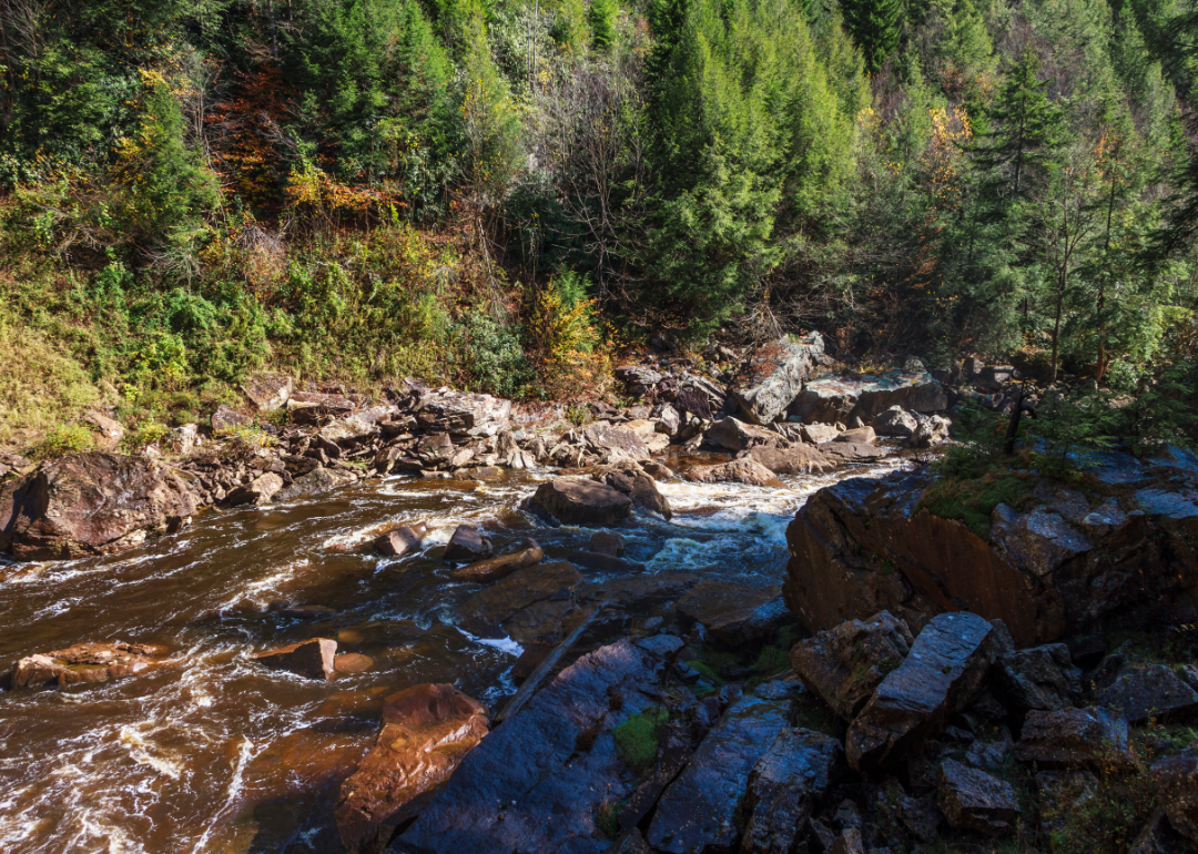
Nicholas County, West Virginia rests in the heart of the state, where forested mountains and clear rivers define its rugged beauty. Its history is tied to timber and coal, industries that built the foundation for its small towns and rural communities. Summersville, the county seat, serves as both a commercial hub and gateway to nearby outdoor destinations.
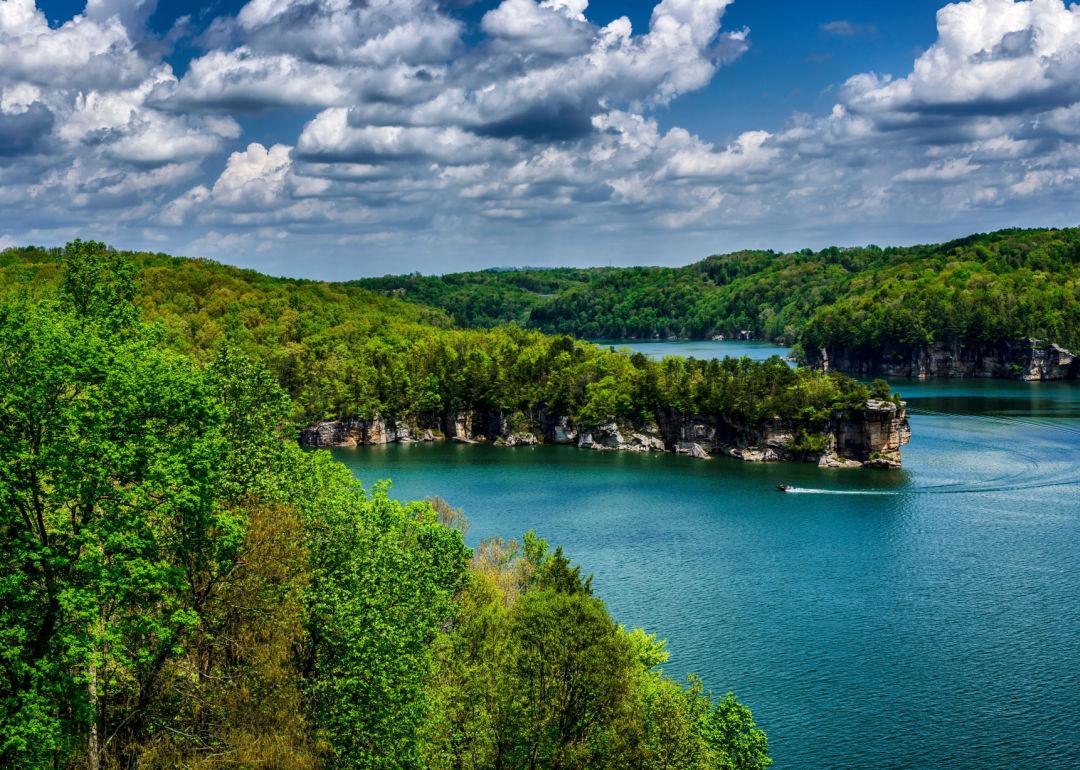
Recreation plays a central role in county life, with Summersville Lake and the Gauley River drawing boaters, hikers, and whitewater enthusiasts. Community pride shows in local festivals, school events, and gatherings that keep traditions strong. Nicholas County reflects both the natural richness of the land and the resilience of its people.
Where is Nicholas County?
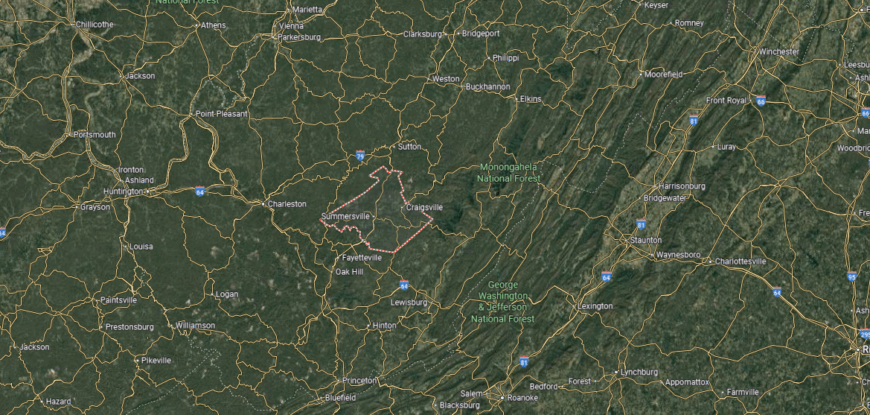
Nicholas County is located in central West Virginia, bordered by Braxton County to the north, Fayette County to the south, and Webster County to the east. It covers about 654 square miles of mountainous terrain in the Allegheny Plateau. Summersville, the county seat, lies near the center along U.S. Route 19 and serves as the largest community.
Other towns include Richwood in the eastern mountains and Craigsville in the northern part of the county. The Gauley River and Summersville Lake are key geographic features that define its landscape. Nicholas County’s location combines rugged highlands, river valleys, and recreational areas in the heart of the state.
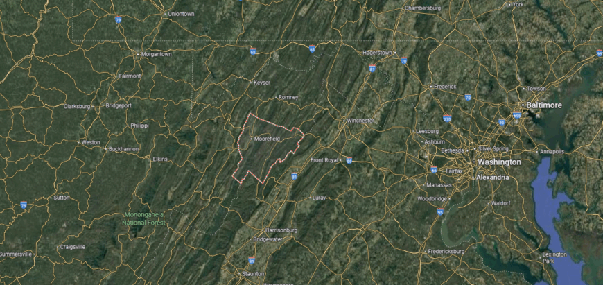
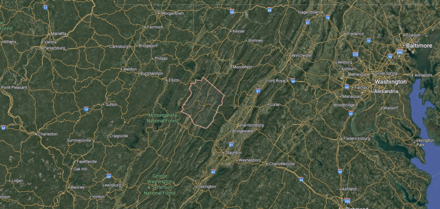
#22. Hardy County, West Virginia
– Overall Rank: Not ranked
– Population: 14,249
– Median household income: $49,205
– Median home value: $153,300 (77% own)
– Median rent: $832 (23% rent)
– Top public schools: Moorefield Middle School (grade B), East Hardy High School (grade B minus), Moorefield High School (grade B minus)
– Top private schools:
– Top places: Moorefield (grade B minus), Wardensville (grade C+)
About
Hardy County, West Virginia lies within the Potomac Highlands, where fertile valleys meet forested ridges and mountain streams. Farming has long been central to its identity, with poultry and cattle shaping the agricultural landscape. Moorefield, the county seat, anchors civic life while maintaining a small-town character rooted in history.
Residents enjoy a blend of tradition and recreation, from county fairs and church gatherings to fishing and hiking in nearby mountains. The South Branch of the Potomac River offers both livelihood and leisure, tying people closely to the land. Hardy County reflects a balance of heritage and natural beauty, sustained by strong community bonds.
Where is Hardy County?
🔥 Would you like to save this?
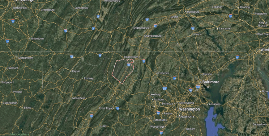
Hardy County lies in the eastern panhandle of West Virginia, bordered by Hampshire County to the north, Pendleton County to the south, and Virginia to the east. It covers about 584 square miles of valleys and mountain ridges within the Appalachian region. Moorefield, the county seat, is located along the South Branch of the Potomac River near the county’s center.
Other communities include Wardensville near the Virginia line and Baker along Corridor H. The county’s terrain is marked by the South Branch Valley and surrounding mountains of the George Washington National Forest. Hardy County’s location highlights its role as both an agricultural area and a gateway to the Shenandoah Valley region.
#21. Pendleton County, West Virginia
– Overall Rank: Not ranked
– Population: 6,156
– Median household income: $52,458
– Median home value: $169,200 (83% own)
– Median rent: $666 (17% rent)
– Top public schools: Brandywine Elementary School (grade A minus), North Fork Elementary School (grade B minus), Franklin Elementary School (grade B minus)
– Top private schools:
– Top places: Franklin (grade A minus), Brandywine (grade C minus)
About
Pendleton County, West Virginia is framed by the Allegheny and Appalachian ranges, where rugged peaks and deep valleys shape its striking landscape. Its history is rooted in farming, frontier settlement, and traditions carried forward through generations in small mountain communities. Franklin, the county seat, serves as a modest hub, surrounded by scenic lands that define daily life.
Residents and visitors alike are drawn to natural landmarks such as Seneca Rocks and Spruce Knob, which highlight the county’s outdoor spirit. Community life revolves around festivals, local gatherings, and traditions that strengthen ties in a rural setting. Pendleton County embodies resilience and connection, where heritage and landscape remain inseparable.
Where is Pendleton County?
Pendleton County is located in eastern West Virginia, bordered by Grant County to the north, Highland County, Virginia, to the east, and Pocahontas County to the south. It spans about 698 square miles of rugged mountains and river valleys in the Allegheny Highlands. Franklin, the county seat, lies near the center along the South Branch of the Potomac River.
Other communities include Circleville in the northern valley and Brandywine near the Virginia border. The county is defined by prominent natural features such as Spruce Knob, the state’s highest peak, and Seneca Rocks. Pendleton County’s location combines remote mountain terrain with rich outdoor recreation and scenic beauty.
#20. Greenbrier County, West Virginia
– Overall Rank: Not ranked
– Population: 32,995
– Median household income: $45,519
– Median home value: $130,400 (75% own)
– Median rent: $790 (25% rent)
– Top public schools: Lewisburg Elementary School (grade B), Rainelle Elementary School (grade B), Frankford Elementary School (grade B)
– Top private schools: Seneca Trail Christian Academy (grade B minus), Lewisburg Baptist Academy (grade C minus), The Greenbrier Community School (grade unavailable)
– Top places: Lewisburg (grade A minus), White Sulphur Springs (grade B minus), Ronceverte (grade B minus)
About
Greenbrier County, West Virginia stretches across the Allegheny Mountains, where valleys, forests, and rivers shape both its beauty and its traditions. Its history is tied to farming, timber, and resort culture, with the famed Greenbrier Resort standing as a landmark of national significance. Lewisburg, the county seat, reflects a blend of historic charm, cultural life, and small-town community spirit.
Festivals, fairs, and markets highlight the county’s agricultural roots while strengthening connections among residents. Outdoor opportunities abound, from hiking and fishing to exploring scenic caves and mountain trails. Greenbrier County stands as a place where heritage, recreation, and culture weave together into a lasting sense of identity.
Where is Greenbrier County?
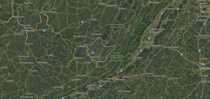
Greenbrier County is in southeastern West Virginia, bordered by Pocahontas County to the north, Monroe County to the south, and Fayette County to the west. It covers more than 1,000 square miles of mountains, valleys, and karst landscapes. Lewisburg, the county seat, is located near the center along U.S. Route 219 and serves as the cultural and administrative hub.
Other communities include Ronceverte along the Greenbrier River, White Sulphur Springs to the east near the Virginia border, and Rainelle in the western mountains. The county is noted for natural landmarks such as the Greenbrier River Trail and Lost World Caverns. Greenbrier County’s location places it in a scenic and historic corridor of the Appalachian Mountains.
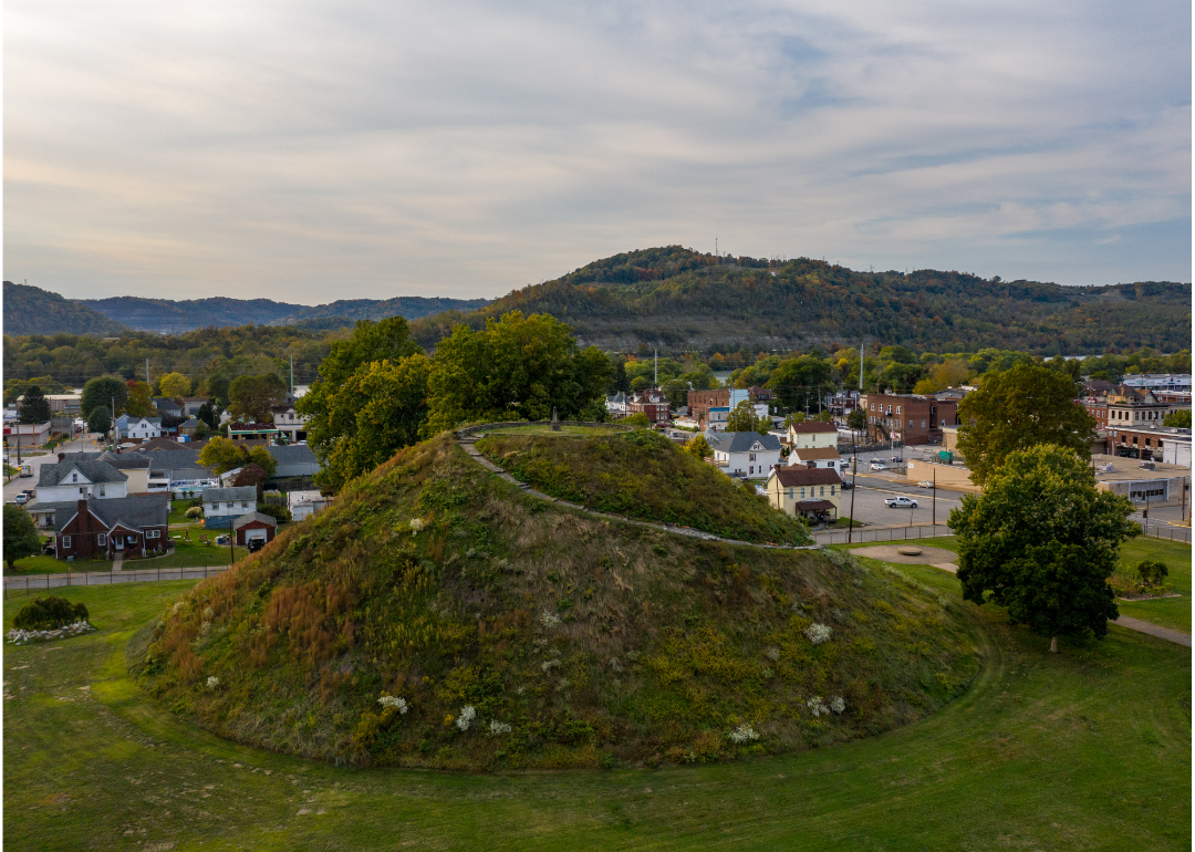
#19. Marshall County, West Virginia
– Overall Rank: Not ranked
– Population: 30,509
– Median household income: $58,129
– Median home value: $130,500 (80% own)
– Median rent: $788 (20% rent)
– Top public schools: Glen Dale Elementary School (grade B+), Washington Lands Elementary School (grade B), Center McMechen Elementary School (grade B)
– Top private schools: Our Lady of Peace School (grade unavailable), St. Francis Xavier School (grade unavailable)
– Top places: Glen Dale (grade A minus), McMechen (grade B), Moundsville (grade B)
About
Marshall County, West Virginia rests along the Ohio River, where rolling hills meet the industrial and agricultural traditions of the valley. Its history is tied to river trade, coal, and steel, which helped shape both its towns and workforce. Moundsville, the county seat, is noted for its historic sites, including the ancient Grave Creek Mound and the former state penitentiary.
Community life thrives through local festivals, school events, and gatherings that reflect strong civic ties. The Ohio River and surrounding hills provide opportunities for both work and recreation, from boating to hunting. Marshall County reflects a balance of historic depth, industrial heritage, and enduring small-town spirit.
Where is Marshall County?
Marshall County is in the northern panhandle of West Virginia, bordered by Ohio to the west across the Ohio River and Pennsylvania to the east. It covers about 310 square miles, with rolling hills on one side and river valleys along its western edge. Moundsville, the county seat, lies on the banks of the Ohio River about 12 miles south of Wheeling.
Other communities include Cameron in the eastern hills and McMechen to the north near the Ohio line. The county is known for the Grave Creek Mound in Moundsville, one of the largest Adena burial mounds in the United States. Marshall County’s location places it along a historic river corridor that links West Virginia with Ohio and Pennsylvania.
#18. Doddridge County, West Virginia
– Overall Rank: Not ranked
– Population: 7,847
– Median household income: $56,587
– Median home value: $147,300 (90% own)
– Median rent: $556 (10% rent)
– Top public schools: Doddridge County Middle School (grade B), Doddridge County Elementary School (grade B minus), Doddridge County High School (grade B minus)
– Top private schools:
– Top places: West Union (grade B)
You may also like: Cities with the fastest-growing home prices in West Virginia

About
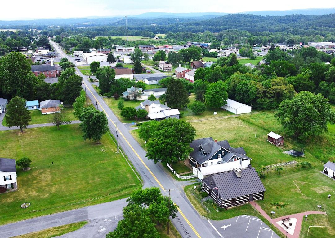
Doddridge County, West Virginia is set in the north-central hills, where forests, creeks, and farmland shape a distinctly rural landscape. Its history grew from early farming and timber, later expanded by oil and gas development that still influences the local economy. The county seat of West Union serves as a center for commerce, schools, and civic traditions.
Community life is carried through fairs, parades, and town gatherings that strengthen social ties. Hunting, fishing, and hiking in the surrounding hills keep outdoor traditions deeply rooted in daily living. Doddridge County reflects a steady rural identity, grounded in both natural resources and enduring heritage.
Where is Doddridge County?
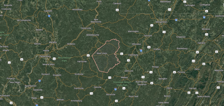
Doddridge County is located in north-central West Virginia, bordered by Tyler County to the north, Harrison County to the east, and Ritchie County to the west. It spans about 320 square miles of wooded hills and valleys in the Appalachian Plateau. West Union, the county seat, sits near the center along U.S. Route 50.
Other small communities include Smithburg to the east and Center Point in the northern part of the county. The county is primarily rural, with landscapes shaped by creeks, ridges, and farmland. Doddridge County’s location highlights its quiet setting between larger hubs like Clarksburg and Parkersburg.
#17. Berkeley County, West Virginia
– Overall Rank: Not ranked
– Population: 123,283
– Median household income: $73,619
– Median home value: $231,600 (75% own)
– Median rent: $1,154 (25% rent)
– Top public schools: Burke Street Elementary School (grade B+), Spring Mills High School (grade B+), Rosemont Elementary School (grade B)
– Top private schools: Faith Christian Academy (grade B), St. Joseph School (grade unavailable), Martinsburg Christian Academy (grade unavailable)
– Top places: Inwood (grade B minus), Martinsburg (grade B minus), Falling Waters (grade B minus)
About
Berkeley County, West Virginia rests in the Eastern Panhandle, where fertile farmland meets the Blue Ridge and the Potomac River. Its history is tied to early colonial settlement, the railroad, and agriculture, creating a foundation of growth that continues today. Martinsburg, the county seat, stands as both a historic hub and a center for modern commerce and culture.
Life in the county blends tradition with opportunity, shaped by festivals, markets, and community gatherings. Outdoor activities along rivers, trails, and mountain foothills add to its character while connecting people to the land. Berkeley County reflects a balance of historic depth and steady progress, carrying forward both heritage and vitality.
Where is Berkeley County?
Berkeley County lies in the eastern panhandle of West Virginia, bordered by Maryland to the north across the Potomac River and Virginia to the south and east. It spans about 322 square miles, making it one of the smaller counties by area but among the fastest growing in population. Martinsburg, the county seat, sits near the center and serves as the region’s largest city.
Other communities include Inwood along Interstate 81 to the south and Falling Waters near the Maryland line. The county’s position along the I-81 corridor links it closely to the Washington, D.C. metropolitan region. Berkeley County’s location makes it a key crossroads of commerce, travel, and history in the eastern panhandle.
#16. Jackson County, West Virginia
– Overall Rank: Not ranked
– Population: 27,868
– Median household income: $55,173
– Median home value: $148,200 (77% own)
– Median rent: $700 (23% rent)
– Top public schools: Evans Elementary School (grade A minus), Fairplain Elementary School (grade B+), Kenna Elementary School (grade B+)
– Top private schools: Heritage Christian Academy (grade unavailable)
– Top places: Ripley (grade B), Ravenswood (grade B minus)

About
Jackson County, West Virginia lies along the Ohio River, where rolling hills and fertile valleys have long supported farming and settlement. Its history is tied to river trade, agriculture, and small industries that shaped the growth of its towns and communities. Ripley, the county seat, serves as both a civic center and home to one of the nation’s oldest Independence Day celebrations.
The rhythm of community life is marked by parades, fairs, and festivals that showcase strong local traditions. Outdoor opportunities range from fishing along the river to exploring wooded hillsides and rural backroads. Jackson County reflects a steady blend of heritage, landscape, and close-knit community spirit.
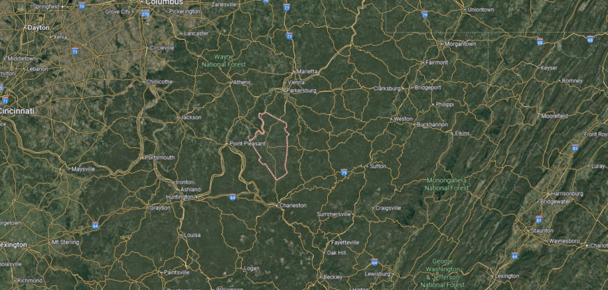
Where is Jackson County?
🔥 Would you like to save this?
Jackson County is located in western West Virginia, bordered by Wood County to the north, Roane County to the east, and Mason County to the south. It spans about 465 square miles of rolling hills and river valleys along the Ohio River. Ripley, the county seat, sits near the center of the county along Interstate 77.
Other communities include Ravenswood on the Ohio River and Kenna in the southern part of the county. The county is positioned about 35 miles north of Charleston and 25 miles south of Parkersburg, giving it direct access to larger urban centers. Jackson County’s location ties together small-town communities, river access, and major highway routes in western West Virginia.
#15. Tyler County, West Virginia
– Overall Rank: 1,329
– Population: 8,336
– Median household income: $59,167
– Median home value: $109,800 (89% own)
– Median rent: $642 (11% rent)
– Top public schools: Arthur I. Boreman Elementary School (grade B+), Sistersville Elementary School (grade B), Tyler Consolidated High School (grade B minus)
– Top private schools: Indian Creek Christian School (grade unavailable)
– Top places: Middlebourne (grade B+), Sistersville (grade B)
About
Tyler County, West Virginia sits along the Ohio River, where river valleys and wooded ridges frame a landscape shaped by both farming and energy development. Its history is rooted in frontier settlement, oil and gas exploration, and the traditions of small-town life that continue to define the region. Middlebourne, the county seat, serves as the center of civic and community activity.
Fairs, festivals, and local gatherings highlight the county’s agricultural and cultural heritage. The Ohio River and surrounding hills provide opportunities for recreation, from boating and fishing to hunting and hiking. Tyler County reflects a heritage of resilience, where land, history, and community remain closely connected.
Where is Tyler County?
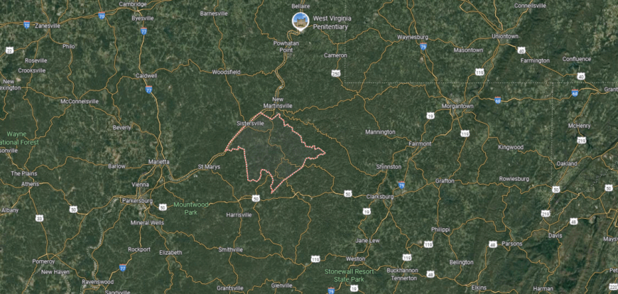
Tyler County is in the northern part of West Virginia, bordered by Wetzel County to the north and Pleasants County to the south. It covers about 260 square miles, with terrain defined by hills, valleys, and stretches of the Ohio River along its western edge. Middlebourne, the county seat, is located near the center of the county.
Other communities include Sistersville, a historic river town on the Ohio, and Friendly to the south along the same corridor. The county lies about 30 miles south of Wheeling and 25 miles north of Parkersburg, placing it within reach of larger regional centers. Tyler County’s position on the Ohio River highlights its historic role in trade and transportation in northern West Virginia.
#14. Raleigh County, West Virginia
– Overall Rank: 1,269
– Population: 74,303
– Median household income: $47,975
– Median home value: $132,300 (75% own)
– Median rent: $819 (25% rent)
– Top public schools: Hollywood Elementary School (grade A minus), Park Middle School (grade A minus), Crescent Elementary School (grade B+)
– Top private schools: Mabscott Christian Academy (grade B+), Victory Baptist Academy (grade B+), Greater Beckley Christian School (grade B)
– Top places: Prosperity (grade B+), Mabscott (grade B+), Shady Spring (grade B)
About
Raleigh County, West Virginia lies in the southern coalfields, where rugged hills and valleys have long shaped both livelihood and culture. Its history is tied to coal mining, timber, and railroads, industries that brought growth and defined many of its communities. Beckley, the county seat, has developed into a regional hub for education, commerce, and cultural life.
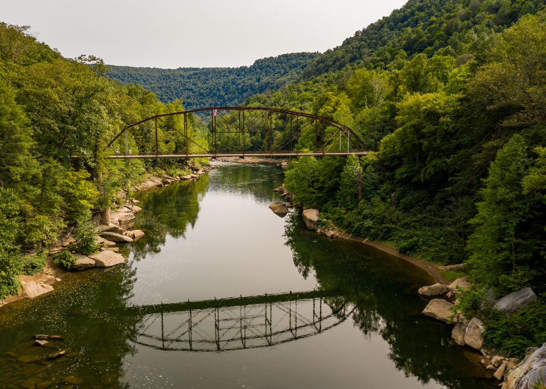
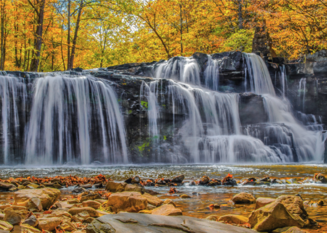
Fairs, festivals, and performing arts highlight the county’s strong community ties. Outdoor recreation thrives in the nearby New River Gorge, offering rafting, climbing, and scenic exploration that connect people to the land. Raleigh County reflects both the heritage of hard work and the evolving spirit of a community adapting to change.
Where is Raleigh County?
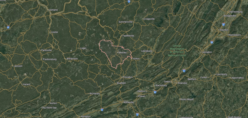
Raleigh County is in southern West Virginia, bordered by Fayette County to the north, Wyoming County to the southwest, and Mercer County to the south. It covers about 609 square miles of the Appalachian Plateau, marked by ridges, valleys, and coalfields. Beckley, the county seat, lies near the center and serves as a major hub for southern West Virginia.
Other communities include Sophia to the west, Mabscott adjoining Beckley, and Lester in the southwestern section. The county sits along major highways such as Interstates 64 and 77, connecting it to Charleston and Bluefield. Raleigh County’s location makes it both a transportation center and a gateway to the state’s southern coalfields and recreation areas.
#13. Mercer County, West Virginia
– Overall Rank: 1,196
– Population: 59,530
– Median household income: $46,409
– Median home value: $115,100 (70% own)
– Median rent: $777 (30% rent)
– Top public schools: Athens Elementary School (grade B+), Glenwood School (grade B+), Princeton Senior High School (grade B)
– Top private schools: Mercer Christian Academy (grade C+)
– Top places: Athens (grade A), Bluefield (grade B+), Princeton (grade B)
You may also like: The top careers hiring for AI skills in West Virginia, according to job postings
About
Mercer County, West Virginia stretches across the Appalachian Plateau, where valleys and ridges frame communities built on coal, rail, and trade. Its history reflects the growth of mining towns, small industries, and cultural traditions that continue to influence local identity. Princeton and Bluefield, the county’s twin hubs, balance historic character with modern centers of commerce and education.
Community spirit is seen in festivals, parades, and civic events that bring people together across towns and neighborhoods. The surrounding mountains provide space for hiking, fishing, and outdoor exploration, keeping ties to the land strong. Mercer County represents both the legacy of its industrial past and the resilience of communities moving steadily forward.
Where is Mercer County?

Mercer County is located in southern West Virginia, bordered by Raleigh County to the north, McDowell County to the west, and Giles County, Virginia, to the east. It spans about 421 square miles of Appalachian Plateau terrain, with a mix of mountains, valleys, and coalfields. Princeton, the county seat, lies near the center along U.S. Route 460 and Interstate 77.
Bluefield, the largest city, is positioned on the Virginia border in the southern part of the county. Other communities include Athens, home to Concord University, and Bramwell near the Bluestone River. Mercer County’s location highlights its role as a regional crossroads between West Virginia and Virginia, with strong ties to both states.
#12. Mineral County, West Virginia
– Overall Rank: 1,165
– Population: 26,957
– Median household income: $64,728
– Median home value: $162,400 (81% own)
– Median rent: $713 (19% rent)
– Top public schools: Elk Garden School (grade B+), Frankfort Middle School (grade B), Frankfort High School (grade B minus)
– Top private schools:
– Top places: Keyser (grade B+), Carpendale (grade C+), Ridgeley (grade B)
About
Mineral County, West Virginia rests in the state’s Eastern Panhandle, where the Potomac River winds between farmland, forests, and mountain ridges. Its history is closely tied to the railroad, coal, and early industry, which brought growth to towns like Keyser, the county seat. The landscape and heritage combine to create a setting where rural traditions meet historic depth.
Local life includes fairs, parades, and cultural gatherings that strengthen bonds within small communities. Outdoor opportunities, from fishing along the Potomac to hiking in the surrounding hills, keep people connected to the land. Mineral County reflects both the resilience of its working past and the steady character of its rural present.
Where is Mineral County?

Mineral County is in the eastern panhandle of West Virginia, bordered by Hampshire County to the south, Grant County to the west, and Maryland to the north and east. It covers about 330 square miles of mountains and river valleys along the Potomac River. Keyser, the county seat, sits near the Maryland border and serves as the county’s largest community.
Other towns include Piedmont on the Potomac River and Ridgeley across from Cumberland, Maryland. The county’s terrain is shaped by the Allegheny Front and the North Branch of the Potomac. Mineral County’s location places it at a vital crossroads between the Appalachian highlands and the industrial centers of western Maryland.
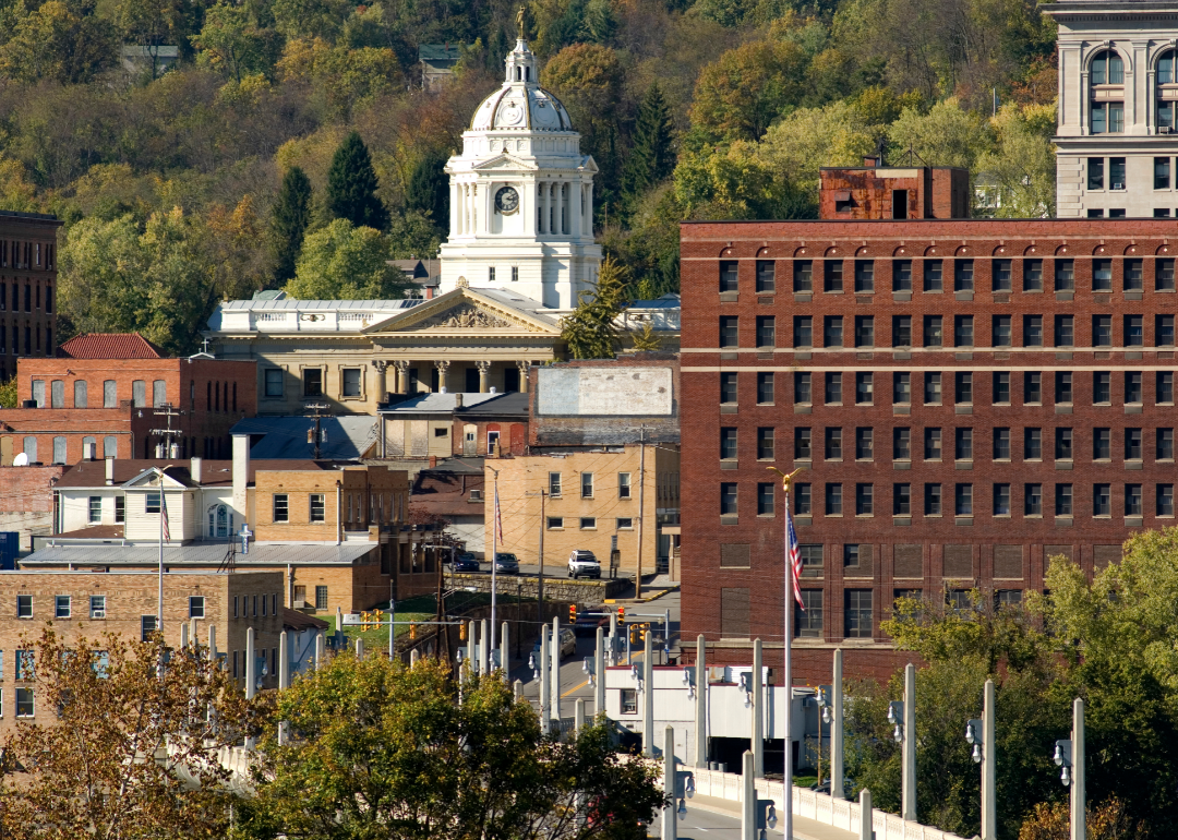
#11. Hancock County, West Virginia
– Overall Rank: 1,139
– Population: 28,907
– Median household income: $57,515
– Median home value: $111,700 (74% own)
– Median rent: $731 (26% rent)
– Top public schools: New Manchester Elementary School (grade B+), Allison Elementary School (grade B+), Oak Glen Middle School (grade B+)
– Top private schools: Weirton Madonna High School (grade B+), St. Joseph the Worker Grade School (grade unavailable), St. Paul School (grade unavailable)
– Top places: Weirton (grade B+), Chester (grade B), Newell (grade C)
🔥 Would you like to save this?
About
Hancock County, West Virginia sits at the state’s northern tip, bordered by the Ohio River and defined by its industrial and riverfront heritage. Its history is marked by steel, pottery, and glass production, industries that shaped the growth of towns like Weirton and Chester. The county also reflects a strong sense of place through its working-class traditions and civic life.
Community rhythms are carried through festivals, parades, and local events that celebrate both history and resilience. The Ohio River provides opportunities for recreation alongside its role in trade and transport. Hancock County embodies the character of a region built on industry, pride, and close-knit community ties.
Where is Hancock County?
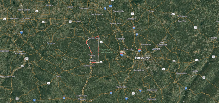
Hancock County is the northernmost county in West Virginia, forming the tip of the state’s narrow panhandle. It is bordered by Ohio to the west across the Ohio River and Pennsylvania to the east, covering just 88 square miles, the smallest county in the state by area. New Cumberland, the county seat, sits along the Ohio River near the center of the county.
Weirton, the largest city, extends across the southern portion and serves as a major industrial hub. Chester, at the northern end, is the northernmost town in West Virginia and borders both Ohio and Pennsylvania. Hancock County’s location gives it a unique tri-state position, connecting West Virginia directly to Pittsburgh’s metropolitan region.
#10. Marion County, West Virginia
– Overall Rank: 1,086
– Population: 56,194
– Median household income: $59,974
– Median home value: $147,600 (75% own)
– Median rent: $870 (25% rent)
– Top public schools: Fairview Middle School (grade A minus), White Hall Elementary School (grade A minus), Pleasant Valley Elementary School (grade A minus)
– Top private schools: Fairmont Catholic Grade School (grade unavailable)
– Top places: Pleasant Valley (grade B+), White Hall (grade B+), Fairmont (grade B)
About
Marion County, West Virginia rests in the north-central region of the state, where the Monongahela River and surrounding hills shape both landscape and history. Its roots are tied to coal mining, glassmaking, and the railroad, industries that fueled the growth of towns and communities. Fairmont, the county seat, has long served as a hub of commerce, culture, and education.
The county’s identity is also reflected in community traditions, from fairs and festivals to gatherings centered on schools and churches. Outdoor spaces along rivers and wooded hills provide recreation that balances work with connection to the land. Marion County represents both the legacy of its industrial past and the steady spirit of its people.
Where is Marion County?
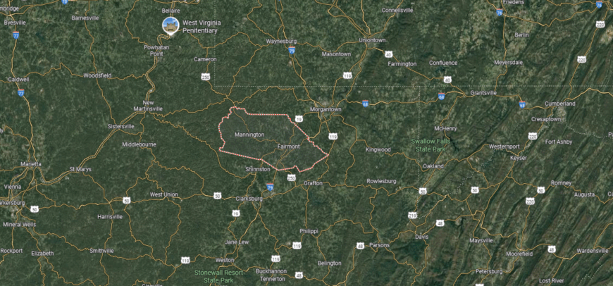
Marion County is in north-central West Virginia, bordered by Monongalia County to the north, Taylor County to the east, and Harrison County to the south. It covers about 312 square miles of hills, valleys, and river corridors along the Monongahela River. Fairmont, the county seat, lies near the center and serves as the largest city.
Other communities include Rivesville and Monongah to the north and Barrackville to the west. The county sits roughly 20 miles south of Morgantown and 20 miles north of Clarksburg, linking it to key regional hubs. Marion County’s location highlights its position along the I-79 corridor, combining small-town communities with access to major transportation routes.
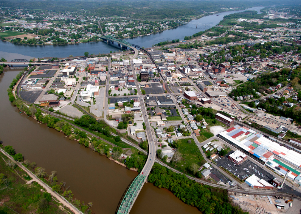
#9. Wood County, West Virginia
– Overall Rank: 926
– Population: 84,272
– Median household income: $54,350
– Median home value: $140,700 (75% own)
– Median rent: $780 (25% rent)
– Top public schools: Greenmont Elementary School (grade A minus), Criss Elementary School (grade A minus), Williamstown Elementary School (grade A minus)
– Top private schools: Parkersburg Catholic High School (grade A minus), Wood County Christian School (grade B), Parkersburg Christian School (grade C+)
– Top places: Williamstown (grade A), Vienna (grade A minus), Blennerhassett (grade A minus)
About
Wood County, West Virginia lies along the Ohio River, where commerce, transportation, and industry have shaped its development for more than two centuries. Early settlement and the growth of trade routes established Parkersburg, the county seat, as an important hub of business and culture. The area’s history blends river commerce, oil, and manufacturing with traditions of civic life and community building.
Fairs, festivals, and local markets highlight the county’s agricultural and cultural heritage. The Ohio River and surrounding hills provide opportunities for boating, hiking, and outdoor recreation that connect people to the landscape. Wood County reflects both the industrious energy of its past and the enduring community spirit of its present.
Where is Wood County?
Wood County is located in western West Virginia along the Ohio River, sharing its western border with the state of Ohio. It spans about 377 square miles of river valleys and rolling hills within the Appalachian Plateau. Parkersburg, the county seat and third-largest city in the state, sits at the confluence of the Ohio and Little Kanawha rivers.
Other communities include Vienna to the north and Williamstown near the Ohio line. The county lies about 75 miles north of Charleston, connected by Interstate 77. Wood County’s location makes it a key hub for river transportation, industry, and regional commerce in the Ohio Valley.
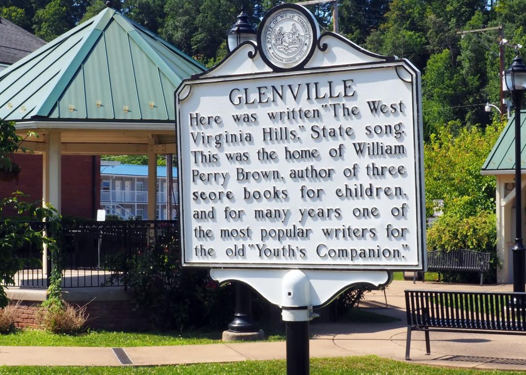
#8. Gilmer County, West Virginia
– Overall Rank: 883
– Population: 7,444
– Median household income: $51,552
– Median home value: $89,800 (74% own)
– Median rent: $670 (26% rent)
– Top public schools: Gilmer County High School (grade C), Leading Creek Elementary School (grade C), Gilmer County Elementary School (grade C minus)
– Top private schools: Normantown Christian Ltd. (grade unavailable)
– Top places: Glenville (grade B+), Sand Fork (grade B)
You may also like: Risky reservoirs: West Virginia counties where aging dams pose the greatest threat
About
Gilmer County, West Virginia is nestled in the state’s center, where wooded hills and valleys create a quiet, rural setting. Its history is tied to farming, timber, and oil, industries that shaped the growth of its small communities. Glenville, the county seat, is home to Glenville State University, which serves as both an educational and cultural anchor.
Civic life revolves around school events, festivals, and local traditions that bring people together. Outdoor activities such as hunting, fishing, and exploring the surrounding countryside remain part of daily rhythms. Gilmer County reflects a steady rural identity, sustained by heritage, education, and community ties.
Where is Gilmer County?
Gilmer County is in central West Virginia, bordered by Calhoun County to the west, Braxton County to the east, and Lewis County to the north. It spans about 340 square miles of hills, ridges, and narrow valleys typical of the Appalachian Plateau. Glenville, the county seat, lies near the center along the Little Kanawha River.
Other small communities include Sand Fork to the east and Normantown to the north. The county is roughly 70 miles northeast of Charleston and 40 miles south of Clarksburg, linking it to larger regional centers. Gilmer County’s location highlights its rural character and central position within the state.
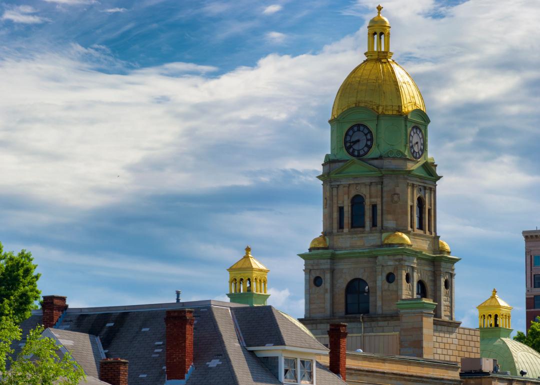
#7. Harrison County, West Virginia
– Overall Rank: 803
– Population: 65,862
– Median household income: $56,184
– Median home value: $146,900 (74% own)
– Median rent: $836 (26% rent)
– Top public schools: Bridgeport High School (grade A minus), Bridgeport Middle School (grade A minus), Johnson Elementary School (grade A minus)
– Top private schools: Notre Dame High School (grade A minus), Heritage Christian School (grade B+), Lasting Impressions Child Development Center (grade unavailable)
– Top places: Bridgeport (grade A+), Clarksburg (grade B+), Nutter Fort (grade B)
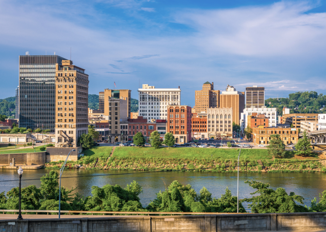
About
Harrison County, West Virginia lies in the north-central region, where valleys and ridges frame communities shaped by industry and tradition. Coal, oil, and glass once fueled its growth, leaving a lasting mark on the economy and culture. Clarksburg, the county seat, developed as a hub of commerce, government, and civic life.
The county’s communities are strengthened through festivals, school events, and cultural gatherings that highlight local pride. Parks, rivers, and wooded hills provide opportunities for recreation, keeping ties to the landscape strong. Harrison County represents a blend of industrial heritage and enduring community spirit, carried forward through generations.
Where is Harrison County?
Harrison County is in north-central West Virginia, bordered by Marion County to the north, Doddridge County to the west, and Lewis County to the south. It covers about 417 square miles of rolling hills and valleys within the Appalachian Plateau. Clarksburg, the county seat, lies near the center and serves as the largest city.
Other communities include Bridgeport to the east, Salem to the west, and Shinnston in the northern section. The county sits along major highways, including Interstate 79, linking it to Morgantown and Charleston. Harrison County’s location makes it a regional hub for transportation, commerce, and community life in north-central West Virginia.
#6. Kanawha County, West Virginia
– Overall Rank: 796
– Population: 179,895
– Median household income: $55,226
– Median home value: $131,200 (70% own)
– Median rent: $868 (30% rent)
– Top public schools: Kenna Elementary School (grade A minus), George Washington High School (grade A minus), Holz Elementary School (grade B+)
– Top private schools: Charleston Catholic High School (grade A minus), Cross Lanes Christian School (grade B), Elk Valley Christian School (grade C)
– Top places: Charleston (grade A minus), South Charleston (grade B+), Cross Lanes (grade B)
About
Kanawha County, West Virginia anchors the central region of the state, where the Kanawha and Elk Rivers converge and shape both settlement and industry. Its history is marked by saltworks, coal, and chemical production, which made the area a center of economic development. Charleston, the state capital and county seat, stands as a hub of government, commerce, and culture.
The county’s character is reflected in festivals, performing arts, and civic gatherings that bring diverse communities together. Outdoor life thrives along riverfronts, parks, and trails that provide balance to its industrial past. Kanawha County embodies both the weight of its historic role in West Virginia and the vitality of a community adapting to modern change.
Where is Kanawha County?

Kanawha County is located in west-central West Virginia, bordered by Putnam County to the west, Fayette County to the east, and Boone County to the south. It is the most populous county in the state, covering about 910 square miles of river valleys and Appalachian hills. Charleston, the county seat and state capital, sits along the Kanawha River near the county’s center.
Other communities include St. Albans and Nitro to the west, Dunbar just outside Charleston, and Clendenin to the north. The county is crossed by Interstates 64, 77, and 79, making it a major transportation hub. Kanawha County’s location places it at the heart of West Virginia’s political, economic, and cultural life.
#5. Jefferson County, West Virginia
– Overall Rank: 570
– Population: 58,043
– Median household income: $93,744
– Median home value: $303,400 (80% own)
– Median rent: $1,073 (20% rent)
– Top public schools: C.W. Shipley Elementary School (grade A minus), Harpers Ferry Middle School (grade B+), Shepherdstown Elementary School (grade B+)
– Top private schools: Wee Disciples Christian Academy (grade unavailable), Jefferson Academy (grade unavailable), Rock Spring Child Learning Center (grade unavailable)
– Top places: Shepherdstown (grade A), Charles Town (grade A minus), Shannondale (grade B minus)
About
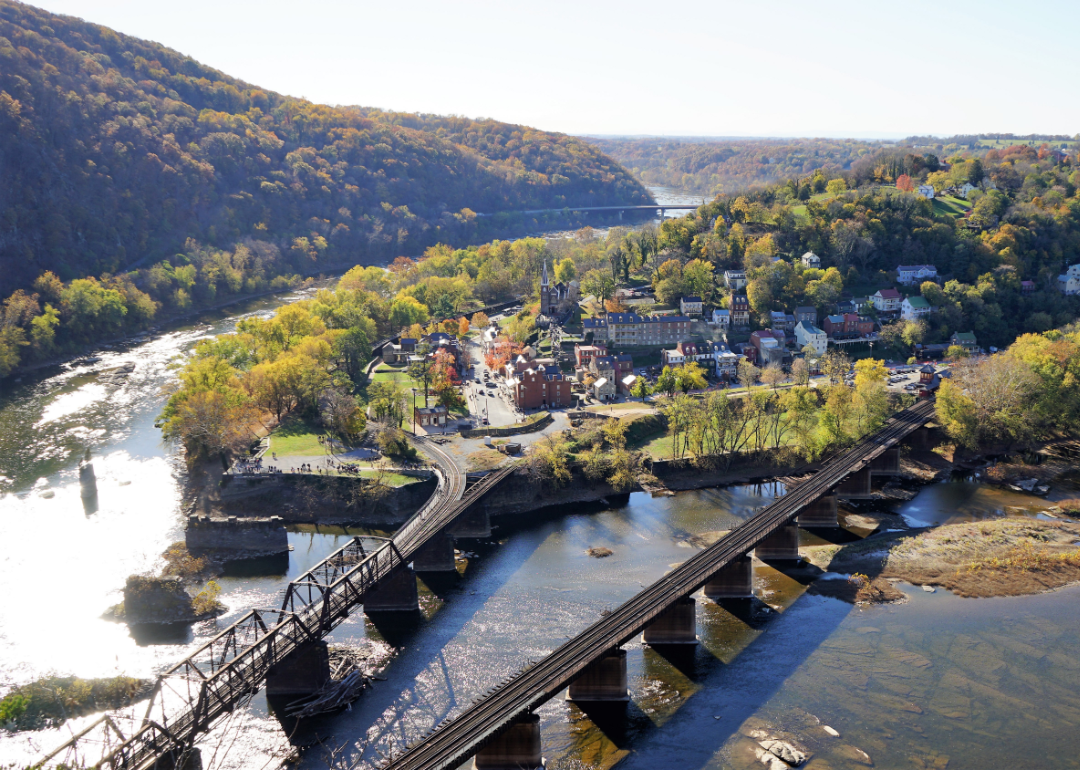
Jefferson County, West Virginia lies in the state’s Eastern Panhandle, where the Shenandoah and Potomac Rivers meet beneath the Blue Ridge. Its history is deeply tied to early settlement, the Civil War, and its role as a crossroads of culture and trade. Charles Town, the county seat, reflects this heritage with historic sites, civic life, and a connection to the surrounding countryside.
Community rhythms include festivals, farmers’ markets, and cultural events that highlight both tradition and growth. Outdoor opportunities abound, from hiking along the Appalachian Trail to exploring river valleys and battlefields. Jefferson County embodies a blend of history, landscape, and enduring civic pride.
Where is Jefferson County?
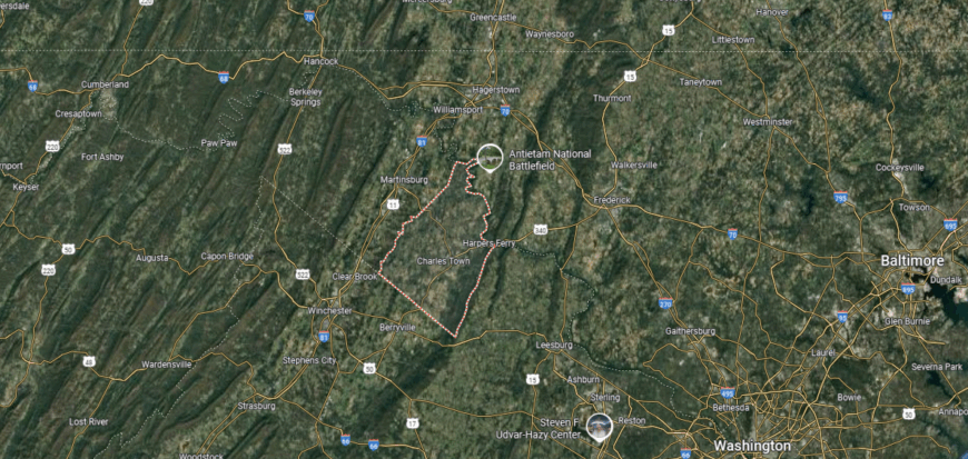
Jefferson County is in the eastern panhandle of West Virginia, bordered by Maryland to the north across the Potomac River and Virginia to the east and south. It spans about 212 square miles, making it one of the smaller counties in the state by area. Charles Town, the county seat, lies near the center and serves as the largest community.
Other towns include Harpers Ferry at the confluence of the Potomac and Shenandoah rivers, and Shepherdstown to the north near the Maryland border. The county sits about 60 miles northwest of Washington, D.C., placing it within the greater metropolitan region. Jefferson County’s location highlights its historic river towns and strategic position at a crossroads of three states.
#4. Cabell County, West Virginia
– Overall Rank: 413
– Population: 93,965
– Median household income: $48,944
– Median home value: $144,200 (65% own)
– Median rent: $857 (35% rent)
– Top public schools: Culloden Elementary School (grade A minus), Hite Saunders Elementary School (grade A minus), Barboursville Middle School (grade B+)
– Top private schools: St. Joseph Catholic High School (grade A minus), Covenant School (grade B+), Grace Christian School (grade B)
– Top places: Barboursville (grade A), Pea Ridge (grade A minus), Culloden (grade B+)

About
Cabell County, West Virginia rests along the Ohio River, where transportation, trade, and industry have long shaped its identity. Founded in the early 19th century, the county grew through river commerce and later railroads, which helped develop Huntington as a regional hub. Today, Huntington serves as the county seat and home to Marshall University, giving the area both cultural and educational prominence.
The county’s sense of community is expressed through festivals, arts, and sporting events that draw people together. Riverfront parks, trails, and nearby hills provide space for recreation and daily connection to the outdoors. Cabell County reflects a balance of historic depth and modern vitality, carrying forward both tradition and progress.
Where is Cabell County?
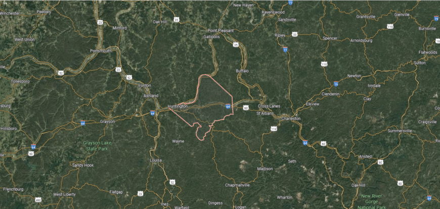
Cabell County is in western West Virginia, bordered by Putnam County to the east, Wayne County to the west, and Mason County to the north. It spans about 288 square miles along the Ohio River, which forms its northern boundary with Ohio. Huntington, the county seat and second-largest city in the state, lies at the confluence of the Guyandotte and Ohio rivers.
Other communities include Barboursville to the east, Milton along Interstate 64, and Culloden near the Putnam County line. The county is about 50 miles west of Charleston and directly connected to Ashland, Kentucky, and Ironton, Ohio. Cabell County’s location places it within a tri-state region, serving as a hub for transportation, education, and commerce.
#3. Putnam County, West Virginia
– Overall Rank: 405
– Population: 57,347
– Median household income: $75,725
– Median home value: $202,300 (82% own)
– Median rent: $1,007 (18% rent)
– Top public schools: West Teays Elementary School (grade A), Winfield Middle School (grade A minus), Rock Branch Elementary School (grade A minus)
– Top private schools: Calvary Baptist Academy (grade B minus), Teays Valley Christian School (grade C+)
– Top places: Winfield (grade A), Teays Valley (grade A), Hurricane (grade A minus)
You may also like: Counties with the most bridges in dire need of repair in West Virginia
About
Putnam County, West Virginia lies along the Kanawha River between Charleston and Huntington, giving it both a rural base and suburban growth. Its history is tied to farming and river trade, later joined by industry and commerce that helped shape expanding communities. Winfield, the county seat, reflects this blend of small-town roots and steady development.
Community pride is expressed through local festivals, school activities, and gatherings that strengthen neighborhood ties. River access and rolling countryside provide opportunities for fishing, hiking, and outdoor recreation. Putnam County embodies a mix of tradition and modern change, where heritage and growth continue to move side by side.
Where is Putnam County?
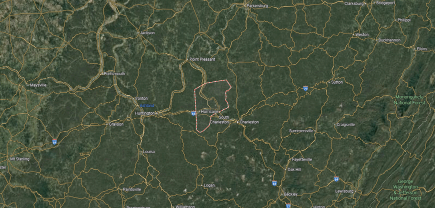
Putnam County is in west-central West Virginia, bordered by Kanawha County to the east, Mason County to the north, and Cabell County to the west. It spans about 350 square miles of river valleys and low hills along the Kanawha River. Winfield, the county seat, is located on the river’s east bank near the county’s center.
Other communities include Hurricane along Interstate 64, Buffalo to the north on the river, and Teays Valley in the central corridor. The county lies roughly midway between Charleston and Huntington, giving it strong ties to both metropolitan areas. Putnam County’s location highlights its role as a growing suburban and commercial link between West Virginia’s two largest cities.
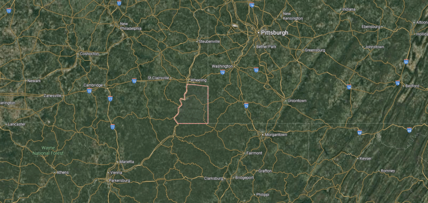
#2. Ohio County, West Virginia
– Overall Rank: 174
– Population: 42,224
– Median household income: $55,521
– Median home value: $153,000 (68% own)
– Median rent: $773 (32% rent)
– Top public schools: Ritchie Elementary School (grade A), Triadelphia Middle School (grade A minus), West Liberty Elementary School (grade A minus)
– Top private schools: The Linsly School (grade A), Central Catholic High School (grade B+), St. Michael Parish School (grade unavailable)
– Top places: Bethlehem (grade A), Wheeling (grade B+), Clearview (grade A minus)
About
Ohio County, West Virginia is set along the Ohio River in the state’s Northern Panhandle, where trade and industry have shaped its history for over two centuries. Wheeling, the county seat, rose as a major river and rail hub, playing a central role in commerce and even serving as the birthplace of West Virginia statehood. The county’s identity reflects this historic depth, blending industry, culture, and civic life.
Cultural traditions are carried forward through festivals, markets, and performances that highlight community pride. Parks, riverfronts, and nearby hills provide space for outdoor recreation and reflection. Ohio County stands as a place where history and progress intersect, sustaining both heritage and vitality in daily life.
Where is Ohio County?

Ohio County is in the northern panhandle of West Virginia, bordered by Pennsylvania to the east and the Ohio River to the west. It is one of the smallest counties in the state, covering just 109 square miles of river valleys and steep hills. Wheeling, the county seat and largest city, sits along the Ohio River and serves as a regional hub.
Other communities include Bethlehem and Triadelphia to the east and West Liberty, home to West Liberty University. The county lies about 60 miles southwest of Pittsburgh, with Interstate 70 running directly through Wheeling. Ohio County’s location makes it a key gateway between West Virginia, Ohio, and Pennsylvania.
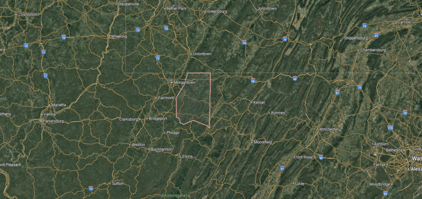
#1. Monongalia County, West Virginia
– Overall Rank: 41
– Population: 105,988
– Median household income: $60,893
– Median home value: $242,100 (57% own)
– Median rent: $929 (43% rent)
– Top public schools: Suncrest Middle School (grade A), North Elementary School (grade A), Mountaineer Middle School (grade A)
– Top private schools: Trinity Christian School (grade B+), Morgantown Christian Academy (grade B minus), St. Francis de Sales Central Catholic School (grade unavailable)
– Top places: Star City (grade A+), Cheat Lake (grade A+), Morgantown (grade A)
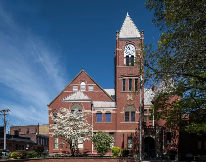
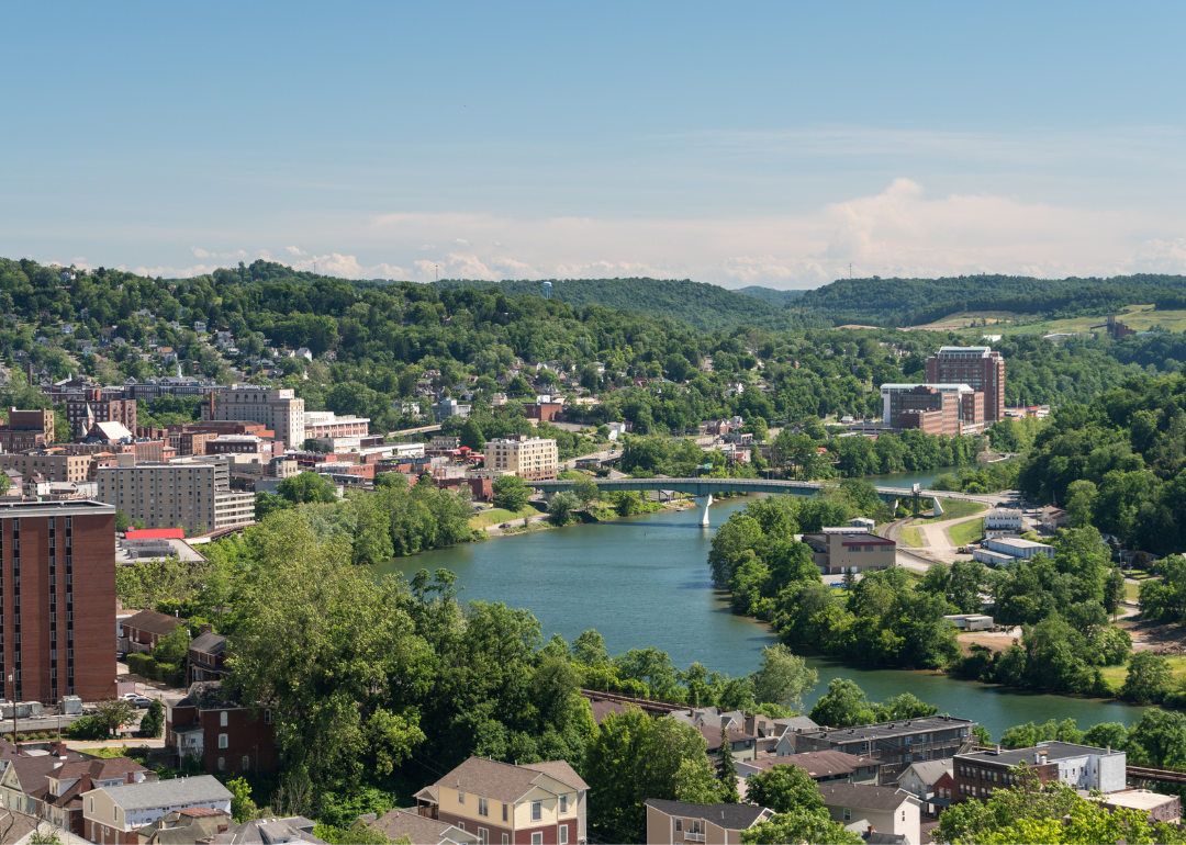
About
Monongalia County, West Virginia sits in the north-central part of the state, where the Monongahela River winds through valleys and wooded hills. Its history is rooted in frontier settlement, coal, and glassmaking, but its modern identity is strongly tied to education and medicine. Morgantown, the county seat, is home to West Virginia University, making the county a hub of culture, research, and innovation.
The presence of the university brings a vibrant rhythm of sports, festivals, and cultural events that connect both residents and visitors. Outdoor recreation thrives along the Mon River trails, Cheat Lake, and the surrounding Appalachian foothills. Monongalia County represents a blend of historic industry and modern progress, sustained by education, community, and landscape.
Where is Monongalia County?
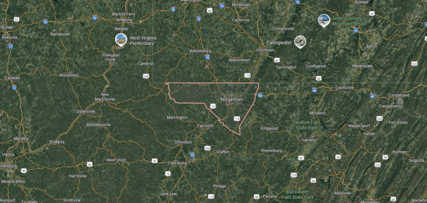
Monongalia County is in north-central West Virginia, bordered by Pennsylvania to the north, Preston County to the east, and Marion County to the south. It spans about 366 square miles of river valleys and Appalachian hills. Morgantown, the county seat and largest city, sits along the Monongahela River near the Pennsylvania border.
Other communities include Westover across the river from Morgantown, Granville to the west, and Star City to the north. The county is about 75 miles south of Pittsburgh, with Interstate 79 and Interstate 68 crossing through it. Monongalia County’s location places it at the center of a growing metropolitan area and home to West Virginia University.
This story features data reporting and writing by Elena Cox and is part of a series utilizing data automation across 50 states.
By Stacker