Best counties to live in Oklahoma based on multiple factors including median home values.
More counties in the United States experienced population growth in the last year, according to the latest Census data, even as pandemic-related moving trends begin to normalize.
In order to come up with the very specific design ideas, we create most designs with the assistance of state-of-the-art AI interior design software. Also, assume links that take you off the site are affiliate links such as links to Amazon. this means we may earn a commission if you buy something.
Counties in the South continued to experience growth, particularly in Florida, where 96% of its 67 counties gained new residents. Polk County, Florida, a suburb of Orlando, added the most, with 26,000 people moving there in 2023.
Meanwhile, counties in the Midwest and Northeast continued to lose population, but at slower rates than the year before. Some of the biggest losses were in counties home to large cities, including Cook County, Illinois (home of Chicago) and the boroughs of Brooklyn and Queens in New York.
Many counties are experiencing growth due to their job opportunities, education, or relatively affordable housing costs. Others are favored for their historic or well-designed downtowns or access to cultural opportunities.
Stacker compiled a list of the best counties to live in Oklahoma using rankings from Niche. Niche ranks counties by various factors including public schools, educational attainment, cost of living, and housing.
Keep reading to see if your county made the list.
You may also like: Cities with the most expensive homes in Oklahoma
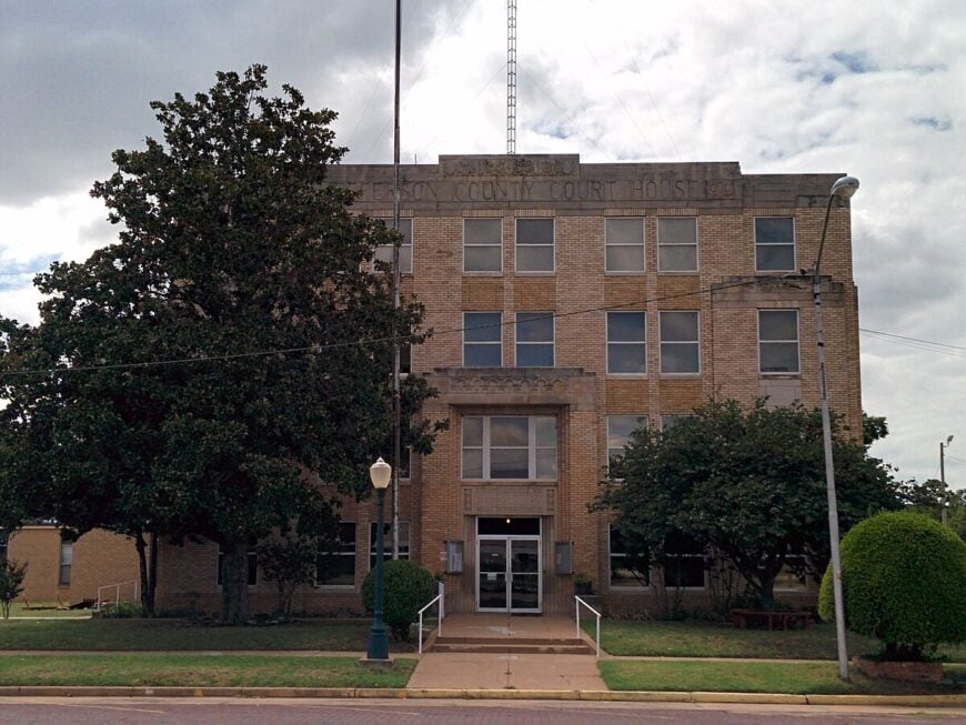
#30. Jefferson County, Oklahoma
– Overall Rank: 730
– Population: 5,420
– Median household income: $48,346
– Median home value: $72,200 (72% own)
– Median rent: $566 (28% rent)
– Top public schools: Waurika Elementary School (grade A minus), Waurika Middle School (grade B+), Waurika High School (grade B)
– Top private schools:
– Top places: Waurika (grade B), Cornish (grade B), Ringling (grade B)
About
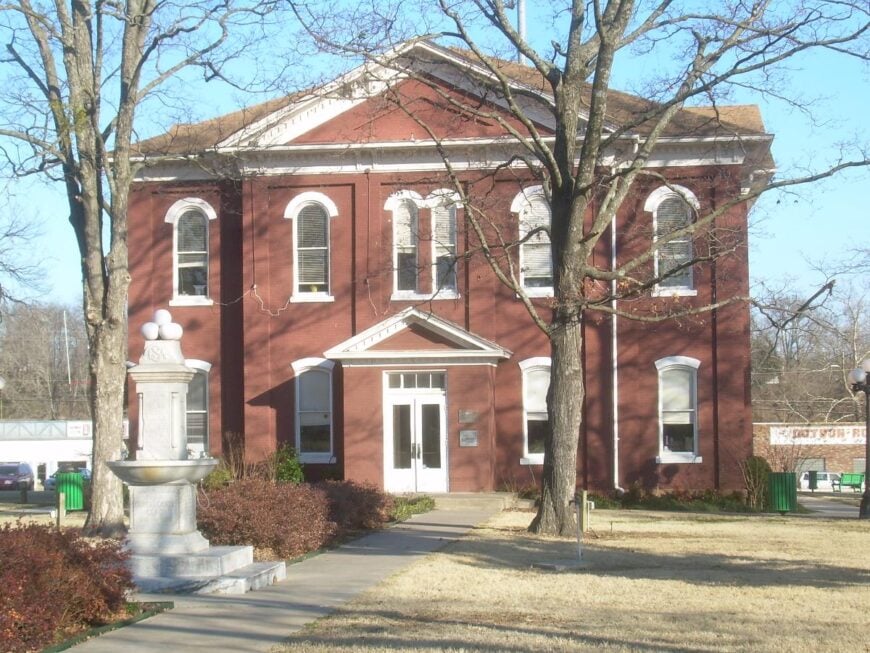
Jefferson County, Oklahoma sits along the Red River in the southern part of the state, where prairies and farmland stretch across the landscape. The county’s past is rooted in ranching, early trade, and the small farming communities that grew around its open lands. Waurika, the county seat, reflects this history while serving as a hub for schools, commerce, and civic traditions.
Cattle production and agriculture continue to shape daily life, while local businesses provide stability for its rural towns. Fairs, rodeos, and community gatherings highlight the county’s enduring character and close-knit spirit. Jefferson County stands as a place where heritage, land, and livelihood remain deeply intertwined.
Where is Jefferson County?
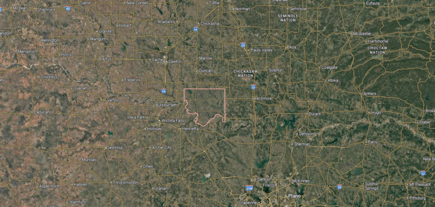
Jefferson County is in southern Oklahoma along the Texas border, with the Red River forming its southern boundary. It covers about 774 square miles of plains and farmland. Waurika, the county seat, lies near the center along U.S. Highway 81, about 35 miles north of Wichita Falls, Texas.
Major routes include U.S. Highways 70 and 81, which cross at Waurika and provide access east to Ardmore and north toward Duncan. Other communities include Ringling to the west and Terral on the Red River near the Texas line. Jefferson County’s location places it directly on a north–south corridor between central Oklahoma and northern Texas.
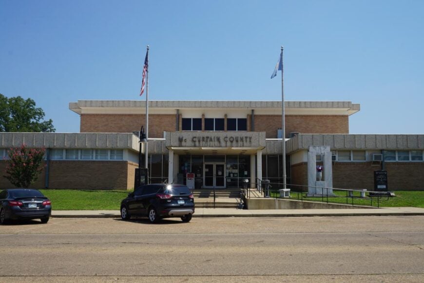
#29. McCurtain County, Oklahoma
– Overall Rank: 720
– Population: 31,003
– Median household income: $47,046
– Median home value: $111,400 (72% own)
– Median rent: $677 (28% rent)
– Top public schools: Lukfata Public School (grade A+), Holly Creek Public School (grade A), Denison Public School (grade A)
– Top private schools:
– Top places: Idabel (grade B+), Broken Bow (grade B), Wright City (grade B)
About
McCurtain County, Oklahoma lies in the southeastern corner of the state, where forests, rivers, and rolling hills give it a distinctly rugged landscape. Its history is tied to Native heritage, timber, and farming, with Idabel serving as the county seat. The presence of natural landmarks such as Beavers Bend State Park and the Mountain Fork River adds to its identity.
Tourism and forestry play major roles in the local economy, alongside agriculture and small businesses that support its communities. Outdoor recreation—from fishing and hiking to camping in state parks—draws both residents and visitors. McCurtain County reflects a way of life where natural resources, culture, and community remain closely connected.
Where is McCurtain County?
McCurtain County is located in the far southeastern corner of Oklahoma, bordered by Texas to the south and Arkansas to the east. It spans more than 1,850 square miles, making it one of the state’s largest counties by area. Idabel, the county seat, sits near the center along U.S. Highways 70 and 259.

The county’s southern boundary follows the Red River, creating a long border with Texas, while the Ouachita Mountains rise in the north. Broken Bow, in the southern part of the county, anchors a key crossroads with U.S. Highway 259 and serves as a gateway to nearby lakes and forests. McCurtain County’s position at the junction of three states gives it both regional and cross-border accessibility.
#28. Texas County, Oklahoma
– Overall Rank: 672
– Population: 21,144
– Median household income: $55,682
– Median home value: $146,200 (68% own)
– Median rent: $865 (32% rent)
– Top public schools: Hooker High School (grade B+), Goodwell Elementary School (grade B), North Park Elementary School (grade B)
– Top private schools: Pioneer Adventist Christian School (grade unavailable)
– Top places: Guymon (grade B), Goodwell (grade A), Texhoma (grade A minus)

About
Texas County, Oklahoma stretches across the Panhandle, where wide plains and open skies define its landscape and way of life. Guymon, the county seat, has grown as a regional hub, shaped by ranching, farming, and the movement of people along historic trails. The county’s history reflects both frontier settlement and the resilience needed to thrive in a challenging environment.
Agriculture—especially cattle, wheat, and hog production—forms the backbone of local livelihood, supported by food processing and trade. Community fairs, rodeos, and cultural gatherings highlight traditions while welcoming newer influences that have come with a growing population. Texas County stands as a place where land, labor, and heritage continue to shape identity.
Where is Texas County?
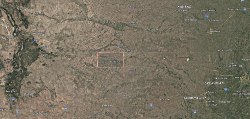
Texas County is in the Oklahoma Panhandle, bordered by Kansas to the north, Texas to the south, and Cimarron and Beaver counties on either side. It covers nearly 2,000 square miles, making it one of the largest counties in the state. Guymon, the county seat, lies near the center along U.S. Highways 54 and 64.
The county’s position places it at the meeting point of three states, with direct routes into southwestern Kansas and the Texas Panhandle. Other communities include Hooker to the north and Goodwell, home to Oklahoma Panhandle State University. Texas County’s location highlights its role as a crossroads of highways and agriculture in the High Plains.
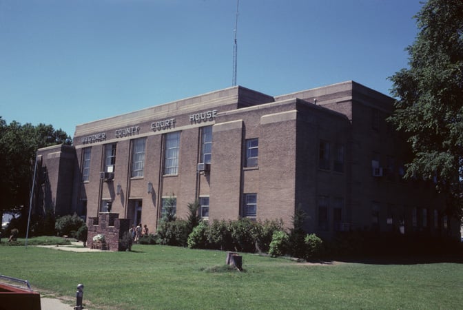
#27. Muskogee County, Oklahoma
– Overall Rank: 663
– Population: 66,606
– Median household income: $50,289
– Median home value: $128,900 (67% own)
– Median rent: $793 (33% rent)
– Top public schools: Fort Gibson Intermediate Elementary School (grade A), Fort Gibson Middle School (grade A), Warner High School (grade A)
– Top private schools: St. Joseph Catholic School (grade unavailable), Boulevard Christian School (grade unavailable), Muskogee Seventh-Day Adventist Christian Academy (grade unavailable)
– Top places: Fort Gibson (grade A), Muskogee (grade B), Warner (grade A minus)
About
Muskogee County, Oklahoma sits in the state’s eastern region, where the Arkansas, Verdigris, and Grand Rivers meet to form a landscape rich in history and trade. Muskogee, the county seat, reflects Native heritage, early settlement, and its role as a transportation hub along the river. Historic sites and cultural institutions keep those traditions visible while the community continues to grow.
The economy is supported by manufacturing, healthcare, agriculture, and river commerce that ties the county to regional trade networks. Festivals, music traditions, and civic events highlight the area’s cultural depth and strong sense of identity. Muskogee County represents a blend of heritage and modern opportunity, where rivers, history, and community remain deeply connected.
Where is Muskogee County?
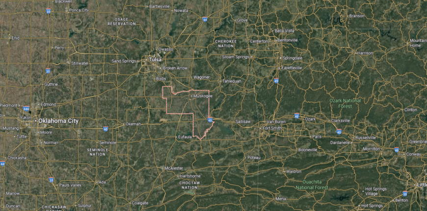
Muskogee County sits in eastern Oklahoma, bordered by Wagoner County to the north, Cherokee County to the east, and McIntosh County to the south. It spans about 840 square miles where the Arkansas, Verdigris, and Grand rivers converge. Muskogee, the county seat, is located near the center along U.S. Highways 62 and 69.
Interstate 40 runs across the southern part of the county, connecting it west toward Oklahoma City and east toward Arkansas. Other towns include Fort Gibson to the northeast and Warner along I-40 to the south. Muskogee County’s position at a river junction and highway crossroads makes it a key access point in eastern Oklahoma.
#26. Grady County, Oklahoma
– Overall Rank: 661
– Population: 55,314
– Median household income: $74,349
– Median home value: $177,100 (75% own)
– Median rent: $841 (25% rent)
– Top public schools: Pioneer Public School (grade A+), Middleberg Public School (grade A), Tuttle Elementary School (grade A)
– Top private schools: James Caraway Christian Academy (grade unavailable), Epworth Christian School (grade unavailable)
– Top places: Tuttle (grade B+), Chickasha (grade B), Ninnekah (grade B minus)
You may also like: The top patent earner in Oklahoma last year
About
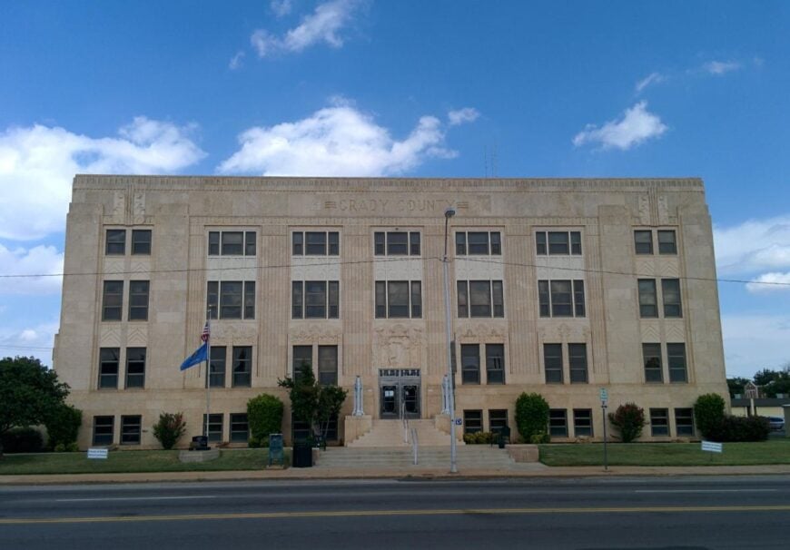
Grady County, Oklahoma rests in the central part of the state, where prairies and farmland have long supported settlement and growth. Chickasha, the county seat, developed as a hub for railroads, agriculture, and trade, shaping the county’s historic identity. Smaller towns across the region carry forward traditions rooted in farming and community life.

Oil, gas, and energy production play a major role in the economy alongside agriculture and manufacturing. Community fairs, festivals, and school events bring residents together while celebrating local pride. Grady County reflects a blend of rural heritage and modern industry, grounded in both land and resilience.
Where is Grady County?
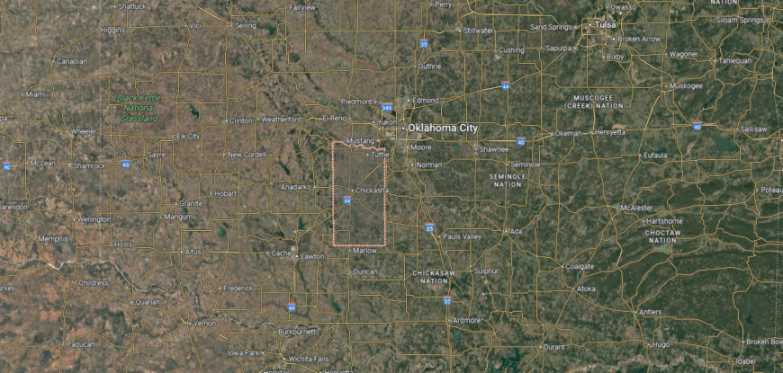
Grady County is in central Oklahoma, bordered by Canadian County to the north, McClain County to the east, and Stephens County to the south. It covers about 1,100 square miles of rolling plains and farmland. Chickasha, the county seat, lies near the center along U.S. Highway 81 and Interstate 44, about 40 miles southwest of Oklahoma City.
The county’s major routes include I-44, which links it directly with Oklahoma City and Lawton, and U.S. Highway 62 running east–west. Other communities include Tuttle in the northeast, Rush Springs in the south, and Minco near the Canadian County line. Grady County’s location provides both suburban access to the Oklahoma City metro and connections to southern Oklahoma.
#25. Noble County, Oklahoma
– Overall Rank: 653
– Population: 10,981
– Median household income: $66,813
– Median home value: $140,900 (80% own)
– Median rent: $710 (20% rent)
– Top public schools: Morrison High School (grade A minus), Perry Elementary School (grade B+), Frontier High School (grade B)
– Top private schools:
– Top places: Perry (grade B+), Morrison (grade B+), Billings (grade B minus)
About
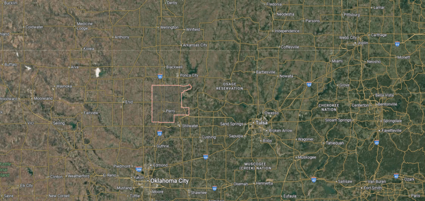
Noble County, Oklahoma lies in the north-central part of the state, where wide prairies and river valleys shape its rural setting. Perry, the county seat, reflects both frontier history and the resilience of small-town life, serving as a center for schools, government, and community traditions. The county’s roots are tied to the Land Run of 1893, which established much of its settlement.
Farming, ranching, and energy production remain the backbone of the local economy, supported by small industries and trade. Community events, fairs, and civic gatherings strengthen bonds across its towns and rural areas. Noble County carries forward a heritage of perseverance, where land and tradition remain closely linked to daily life.
Where is Noble County?
🔥 Would you like to save this?
Noble County is located in north-central Oklahoma, bordered by Kay County to the north, Payne County to the east, and Logan County to the south. It spans about 743 square miles of plains and farmland. Perry, the county seat, lies near the center along Interstate 35, about 60 miles north of Oklahoma City.
The county is crossed by I-35, which provides a direct north–south corridor through the state, and U.S. Highway 64, which runs east–west through Perry. Other towns include Morrison in the northeast and Red Rock near the northern boundary. Noble County’s location gives it strong highway access while maintaining a largely rural setting in north-central Oklahoma.
#24. Kingfisher County, Oklahoma
– Overall Rank: 598
– Population: 15,290
– Median household income: $65,167
– Median home value: $189,000 (74% own)
– Median rent: $905 (26% rent)
– Top public schools: Kingfisher Middle School (grade A), Heritage Elementary School (grade A), Cashion Elementary School (grade A minus)
– Top private schools: Holy Trinity Catholic School (grade unavailable), Sts. Peter & Paul School (grade unavailable)
– Top places: Kingfisher (grade B), Cashion (grade B+), Hennessey (grade B)
About
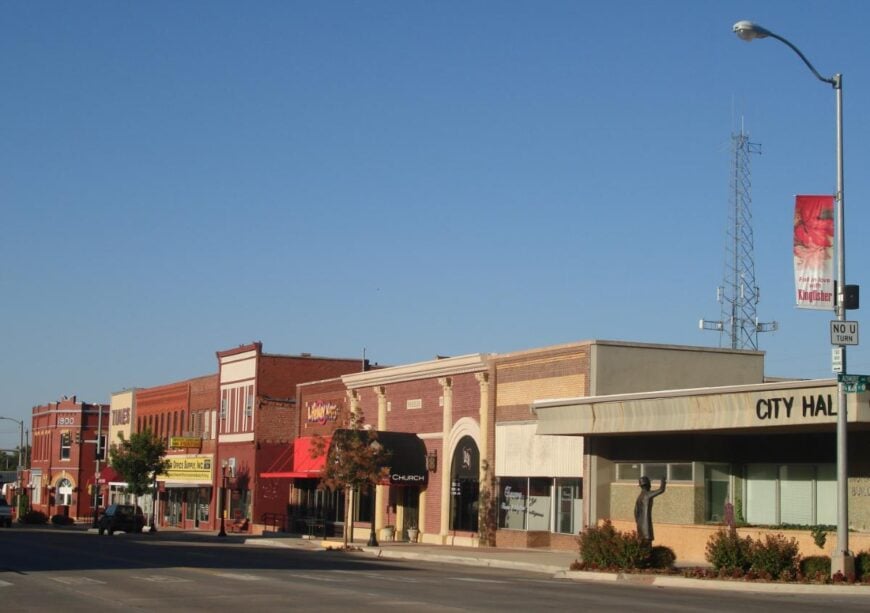
Kingfisher County, Oklahoma rests in the north-central plains, where fertile farmland and open skies define its character. Kingfisher, the county seat, reflects a heritage rooted in the Land Run of 1889 and continues to serve as the center of civic and community life. Small towns and rural communities across the county maintain strong ties to the land and local traditions.
Agriculture, especially wheat and cattle, remains a cornerstone of the economy, supported by energy production and small industries. Festivals, fairs, and school-centered events highlight community pride and bring residents together. Kingfisher County represents a place where history, land, and livelihood continue to shape a steady rural identity.
Where is Kingfisher County?
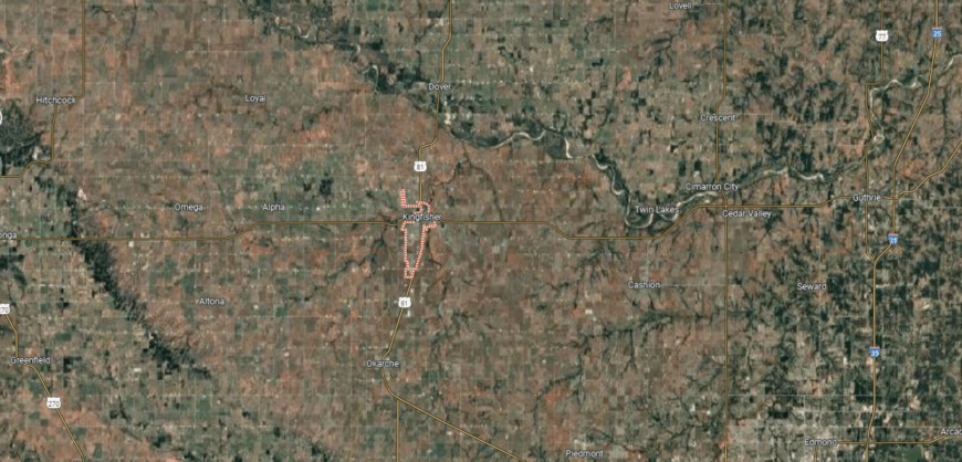
Kingfisher County is in central Oklahoma, bordered by Garfield County to the north, Logan County to the east, and Canadian County to the south. It spans about 906 square miles of farmland and prairie. Kingfisher, the county seat, sits near the center along U.S. Highway 81, about 45 miles northwest of Oklahoma City.
The county is served by U.S. Highways 81 and 33, linking it north toward Enid, south toward Oklahoma City, and east toward Guthrie. Other communities include Hennessey on the northern edge and Okarche near the southern border. Kingfisher County’s location gives it both direct access to the Oklahoma City metro and ties to northwestern Oklahoma.
#23. Tillman County, Oklahoma
– Overall Rank: 587
– Population: 7,013
– Median household income: $46,306
– Median home value: $62,900 (73% own)
– Median rent: $682 (27% rent)
– Top public schools: Davidson Elementary School (grade A), Frederick Middle School (grade A minus), Frederick Elementary School (grade B+)
– Top private schools:
– Top places: Frederick (grade B), Davidson (grade B+), Tipton (grade B)
About
Tillman County, Oklahoma lies along the Red River in the state’s southern plains, where wide fields and open skies reflect its strong agricultural base. Frederick, the county seat, serves as the center of civic life and carries forward traditions rooted in farming communities. The county’s history is tied to early settlement, the railroad, and the steady development of rural towns.
Cotton, wheat, and livestock anchor the economy, supported by agribusiness and small industries. Local fairs, festivals, and school events foster community pride and keep traditions alive across generations. Tillman County reflects a rural identity built on land, heritage, and the resilience of its people.
Where is Tillman County?
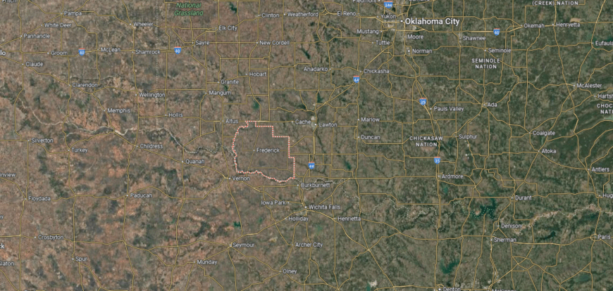
Tillman County is located in southwestern Oklahoma, bordered by Kiowa County to the north, Cotton County to the east, and the Red River to the south, which forms the boundary with Texas. It spans about 879 square miles of agricultural plains. Frederick, the county seat, lies near the center along U.S. Highways 70 and 183.
The county’s southern edge provides multiple crossings into Texas, linking it with Wichita Falls and Vernon. Other communities include Grandfield near the Cotton County line and Tipton to the northwest. Tillman County’s position on the Red River makes it both a border county and an agricultural hub in southwestern Oklahoma.
#22. Caddo County, Oklahoma
– Overall Rank: 571
– Population: 26,910
– Median household income: $52,443
– Median home value: $99,900 (72% own)
– Median rent: $686 (28% rent)
– Top public schools: Lookeba-Sickles Elementary School (grade A minus), Fort Cobb-Broxton High School (grade A minus), Fort Cobb-Broxton Lower Elementary School (grade B+)
– Top private schools:
– Top places: Anadarko (grade B minus), Fort Cobb (grade A minus), Hydro (grade B+)

About
Caddo County, Oklahoma sits in the state’s southwest, where prairies, rivers, and rolling hills shape both its landscape and its history. Anadarko, the county seat, is known for its deep Native heritage, serving as home to several tribal nations and cultural institutions. The county’s identity reflects this blend of Indigenous traditions, frontier settlement, and agricultural roots.
Farming and ranching remain central, while energy production and small industries add to the economic base. Cultural events, powwows, and community gatherings highlight the area’s diverse heritage and strong social ties. Caddo County stands as a place where history, culture, and land come together in a lasting way.
Where is Caddo County?
Caddo County is in southwestern Oklahoma, bordered by Blaine County to the north, Grady County to the east, and Comanche County to the south. It covers about 1,278 square miles of prairie, river valleys, and rolling hills. Anadarko, the county seat, lies near the center along U.S. Highways 62 and 281.
The county is served by several major routes, including U.S. Highway 62 running east–west and U.S. Highway 281 running north–south. Other towns include Carnegie in the west, Cement to the southeast, and Fort Cobb near the central lakes area. Caddo County’s location places it at the junction of agricultural lands, tribal communities, and key transportation corridors in southwestern Oklahoma.
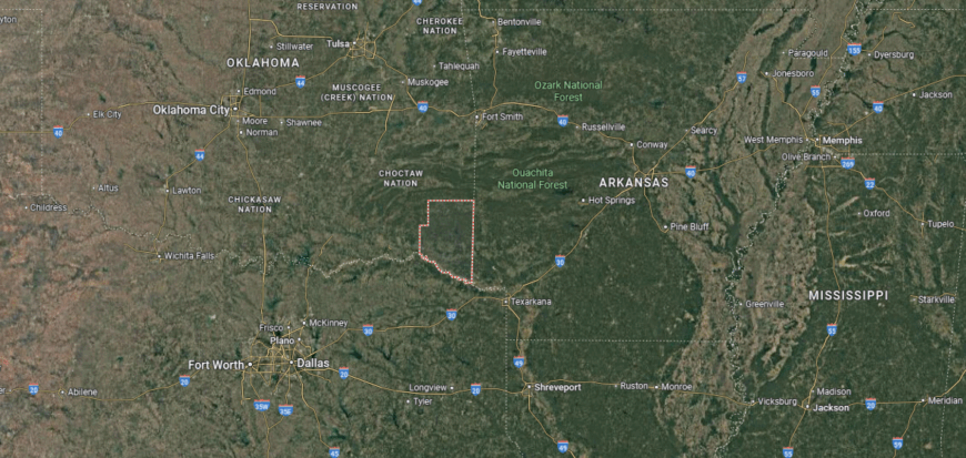
#21. Bryan County, Oklahoma
– Overall Rank: 560
– Population: 46,528
– Median household income: $54,289
– Median home value: $151,500 (64% own)
– Median rent: $877 (36% rent)
– Top public schools: Durant Middle School (grade A), Northwest Heights Elementary School (grade A), Caddo High School (grade A)
– Top private schools: Victory Life Academy (grade B)
– Top places: Calera (grade B+), Durant (grade B+), Silo (grade A minus)
You may also like: Which movies were filmed in Oklahoma?
About
Bryan County, Oklahoma lies along the Red River in the southeastern part of the state, where farmland, forests, and small towns shape its character. Durant, the county seat, is home to Southeastern Oklahoma State University and the headquarters of the Choctaw Nation, both of which play a major role in community and regional life. The county’s history reflects Native heritage, early settlement, and the steady growth of trade and education.
Agriculture, education, and tribal enterprises form a strong base for the local economy, while manufacturing and retail add diversity. Festivals, cultural events, and university programs bring residents together and highlight the county’s unique identity. Bryan County represents a place where tradition, progress, and community pride remain closely connected.
Where is Bryan County?
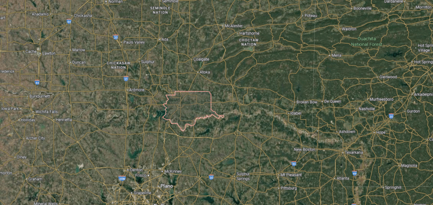
Bryan County is in southern Oklahoma, bordered by Marshall County to the west, Atoka County to the north, and the Red River to the south, which separates it from Texas. It spans about 944 square miles of farmland, river bottoms, and rolling hills. Durant, the county seat, sits near the center along U.S. Highway 69/75, about 10 miles north of the Texas line.
Interstate 69/75 runs north–south through Durant, linking the county directly with Dallas to the south and Tulsa to the north. U.S. Highway 70 crosses east–west, connecting communities such as Mead, Bennington, and Calera. Bryan County’s position on the Red River makes it a key gateway between southeastern Oklahoma and northern Texas.
#20. Wagoner County, Oklahoma
– Overall Rank: 553
– Population: 82,269
– Median household income: $75,082
– Median home value: $201,600 (80% own)
– Median rent: $1,000 (20% rent)
– Top public schools: Rosewood Elementary School (grade A minus), Timber Ridge Elementary School (grade A minus), Highland Park Elementary School (grade A minus)
– Top private schools: Destiny Christian Academy (grade unavailable), Joyland Child Development Center, Inc. (grade unavailable)
– Top places: Coweta (grade B+), Wagoner (grade B minus), Okay (grade B minus)
About
Wagoner County, Oklahoma rests in the northeastern part of the state, where lakes, rivers, and farmland create a balance between rural and suburban life. Wagoner, the county seat, reflects a small-town character rooted in history, while nearby communities benefit from the county’s proximity to Tulsa. The land itself, shaped by the Arkansas and Verdigris Rivers, has long supported farming and settlement.
Agriculture continues to play a role, but growth in manufacturing, retail, and service industries has broadened the economy. Fort Gibson Lake and other outdoor destinations attract recreation and tourism, adding to the county’s vitality. Wagoner County reflects both its historic rural base and the expanding opportunities of modern development.
Where is Wagoner County?
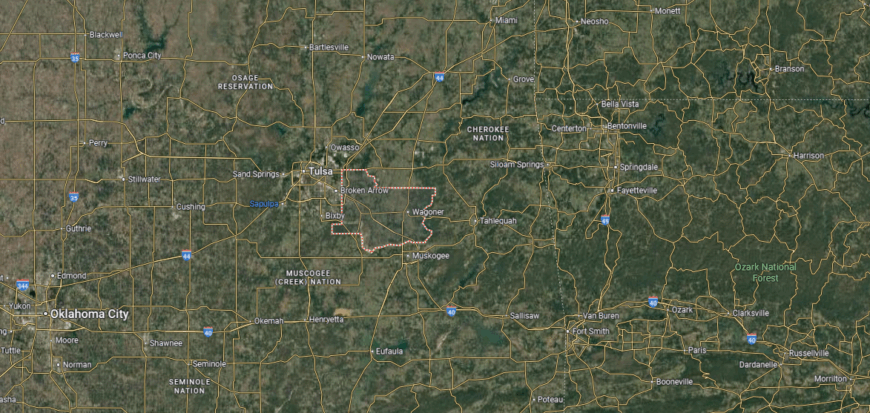
Wagoner County is in northeastern Oklahoma, bordered by Rogers County to the north, Cherokee County to the east, and Muskogee County to the south. It covers about 590 square miles of prairie, hills, and lakeshore. Wagoner, the county seat, lies near the center along U.S. Highways 69 and 51.
The county is crossed by major routes including U.S. Highway 69 running north–south and U.S. Highway 51 connecting west to Tulsa. Other communities include Coweta in the northwest and Porter near the western edge. Wagoner County’s location places it within the Tulsa metropolitan area while still connecting directly to eastern Oklahoma.
#19. McClain County, Oklahoma
– Overall Rank: 547
– Population: 42,393
– Median household income: $80,150
– Median home value: $214,400 (79% own)
– Median rent: $920 (21% rent)
– Top public schools: Washington Elementary School (grade A minus), Washington Middle School (grade A minus), Blanchard Intermediate School (grade A minus)
– Top private schools: Shiloh Christian Academy (grade unavailable)
– Top places: Goldsby (grade A), Blanchard (grade A minus), Newcastle (grade A minus)
About
McClain County, Oklahoma sits in the central part of the state, where open plains and rolling hills form the backdrop for its communities. Purcell, the county seat, is known as the “Heart of Oklahoma” and serves as a hub for trade, schools, and civic life. The county’s history is tied to farming, ranching, and the early development of railroads that connected the region.
While agriculture remains important, the economy has expanded into energy, manufacturing, and services linked to nearby metropolitan growth. Local fairs, rodeos, and festivals continue to showcase community pride and rural traditions. McClain County represents a blend of heritage and progress, where small-town life thrives alongside modern opportunity.
Where is McClain County?
🔥 Would you like to save this?
McClain County is in central Oklahoma, bordered by Cleveland County to the east, Grady County to the west, and Garvin County to the south. It spans about 580 square miles of plains and gently rolling hills. Purcell, the county seat, sits near the center along Interstate 35, about 40 miles south of Oklahoma City.
I-35 serves as the main north–south corridor, linking the county directly to Oklahoma City and Dallas. U.S. Highways 62 and 77 also cross through, connecting Purcell with nearby towns and regions. Other communities include Blanchard in the northwest and Washington just south of Purcell, highlighting the county’s role as a growing suburban and transportation hub.
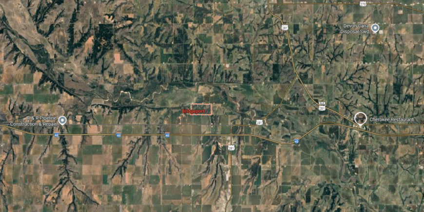
#18. Garfield County, Oklahoma
– Overall Rank: 489
– Population: 62,456
– Median household income: $64,165
– Median home value: $142,000 (66% own)
– Median rent: $868 (34% rent)
– Top public schools: Chisholm Elementary School (grade A), Chisholm Middle School (grade A), Garber High School (grade A)
– Top private schools: Oklahoma Bible Academy (grade B+), Emmanuel Christian School (grade unavailable), St. Joseph Catholic School (grade unavailable)
– Top places: Enid (grade B+), North Enid (grade B), Garber (grade B+)

About
Garfield County, Oklahoma rests in the north-central plains, where fertile farmland and wide skies have long supported settlement and growth. Enid, the county seat, developed as a major grain hub and rail center, giving the area a lasting reputation as the “Wheat Capital.” Smaller towns across the county maintain strong ties to agriculture and rural traditions.
Farming and cattle remain vital, while energy production, manufacturing, and healthcare add diversity to the local economy. Festivals, fairs, and community events highlight both agricultural pride and civic life. Garfield County reflects a blend of historic resilience and modern opportunity, rooted in its land and people.
Where is Garfield County?
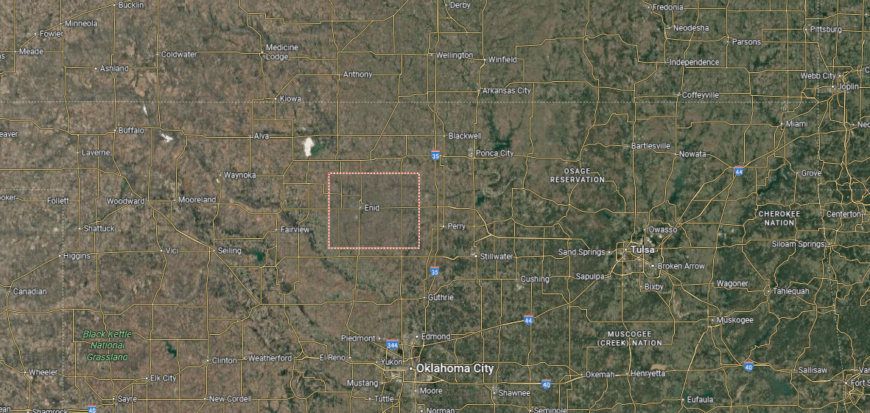
Garfield County is in north-central Oklahoma, bordered by Grant County to the north, Kingfisher County to the south, and Major County to the west. It covers about 1,060 square miles of prairie and farmland. Enid, the county seat and one of the largest cities in the region, lies near the center along U.S. Highways 60, 81, and 412.
The county is served by U.S. Highway 81 running north–south and U.S. Highways 60 and 412 running east–west, giving it strong regional access. Other towns include Waukomis to the south, Garber to the east, and Covington in the southeast. Garfield County’s central location makes it a key agricultural and transportation hub in northern Oklahoma.
#17. Murray County, Oklahoma
– Overall Rank: 460
– Population: 13,837
– Median household income: $60,213
– Median home value: $148,200 (73% own)
– Median rent: $824 (27% rent)
– Top public schools: Sulphur Middle School (grade A minus), Sulphur Intermediate School (grade B+), Davis Middle School (grade B+)
– Top private schools:
– Top places: Sulphur (grade A minus), Davis (grade B+), Dougherty (grade B)
About
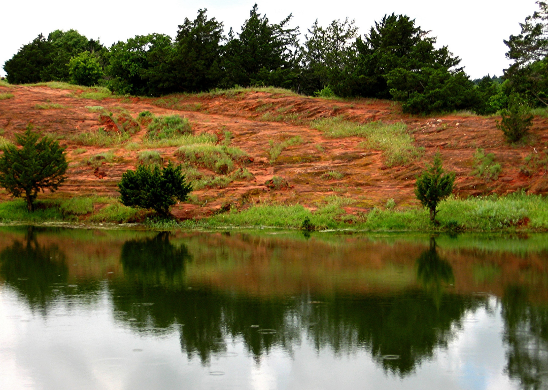
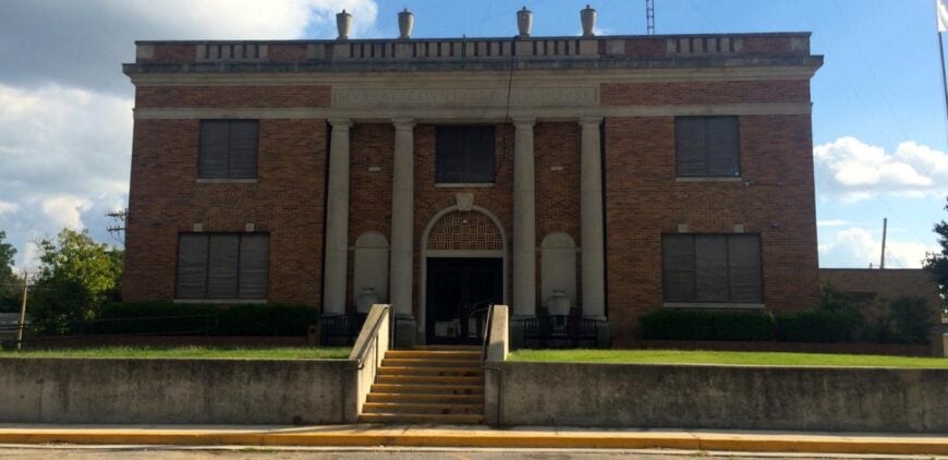
Murray County, Oklahoma lies in the south-central part of the state, where the Arbuckle Mountains create a rugged landscape of hills, springs, and valleys. Sulphur, the county seat, is known for its ties to the Chickasaw Nation and as the gateway to the Chickasaw National Recreation Area. The county’s history is shaped by Native heritage, early settlement, and the natural springs that drew people to the region.
Tourism plays a central role in the economy, with recreation, hospitality, and small businesses supported by the county’s natural attractions. Agriculture and ranching continue to contribute, reflecting its rural foundation. Murray County represents a place where heritage, land, and community life are bound closely together.
Where is Murray County?
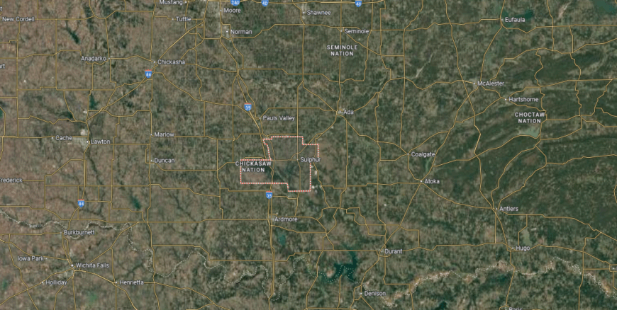
Murray County is in south-central Oklahoma, bordered by Garvin County to the north, Carter County to the south, and Pontotoc County to the east. It spans about 425 square miles of rolling hills and river valleys. Sulphur, the county seat, is located near the center along U.S. Highway 177, about 85 miles south of Oklahoma City.
The county is crossed by U.S. Highway 177 north–south and State Highway 7 east–west, linking it to Ada, Davis, and Ardmore. Other communities include Davis along Interstate 35 and Hickory to the northeast. Murray County’s location combines highway access with proximity to the Arbuckle Mountains and Chickasaw National Recreation Area.
#16. Rogers County, Oklahoma
– Overall Rank: 408
– Population: 95,870
– Median household income: $75,312
– Median home value: $206,300 (77% own)
– Median rent: $980 (23% rent)
– Top public schools: Pamela Hodson Elementary School (grade A), Justus-Tiawah Public School (grade A), Stone Canyon Elementary School (grade A minus)
– Top private schools: Claremore Christian School (grade B), Legacy Christian School (grade unavailable), Claremore Children’s Center (grade unavailable)
– Top places: Verdigris (grade A minus), Claremore (grade A minus), Justice (grade A minus)
You may also like: Fastest-growing jobs in Oklahoma
About
Rogers County, Oklahoma sits in the northeastern part of the state, where rolling hills and fertile ground support both rural communities and suburban growth. Claremore, the county seat, is known for its historic downtown, ties to Route 66, and its association with Will Rogers, whose legacy continues to shape local identity. The county’s setting blends small-town character with the influence of nearby Tulsa.
Agriculture, manufacturing, and energy contribute strongly to the economy, while retail and services have grown with the county’s expanding population. Cultural events, museums, and festivals highlight its history and community pride. Rogers County reflects a mix of tradition and progress, where heritage and development move hand in hand.
Where is Rogers County?
Rogers County is in northeastern Oklahoma, bordered by Nowata County to the north, Mayes County to the east, and Tulsa County to the southwest. It covers about 711 square miles of prairie and gently rolling hills. Claremore, the county seat, is located near the center along historic Route 66 and U.S. Highway 66/Will Rogers Boulevard.
Interstate 44 runs diagonally across the county, providing a direct link to Tulsa and Joplin, Missouri. U.S. Highways 169 and 412 also cross through, connecting towns such as Catoosa, Inola, and Oologah. Rogers County’s location places it firmly within the Tulsa metropolitan area while still serving as a gateway to northeastern Oklahoma.
#15. Woods County, Oklahoma
– Overall Rank: 363
– Population: 8,661
– Median household income: $50,724
– Median home value: $146,700 (69% own)
– Median rent: $793 (31% rent)
– Top public schools: Longfellow Elementary School (grade A minus), Freedom Elementary School (grade B+), Lincoln Elementary School (grade B+)
– Top private schools:
– Top places: Alva (grade A minus), Waynoka (grade B+), Freedom (grade B)
About
Woods County, Oklahoma lies in the northwestern part of the state, where open prairies and wide skies define both its scenery and its way of life. Alva, the county seat, serves as a hub of education, culture, and civic activity, supported by Northwestern Oklahoma State University. The county’s roots reach back to farming, ranching, and frontier settlement that shaped its early communities.
Wheat, cattle, and energy production remain central to the local economy, with small businesses adding stability across its towns. Community events, rodeos, and university programs provide opportunities for connection and shared pride. Woods County reflects a rural identity strengthened by heritage, education, and the enduring relationship between land and people.
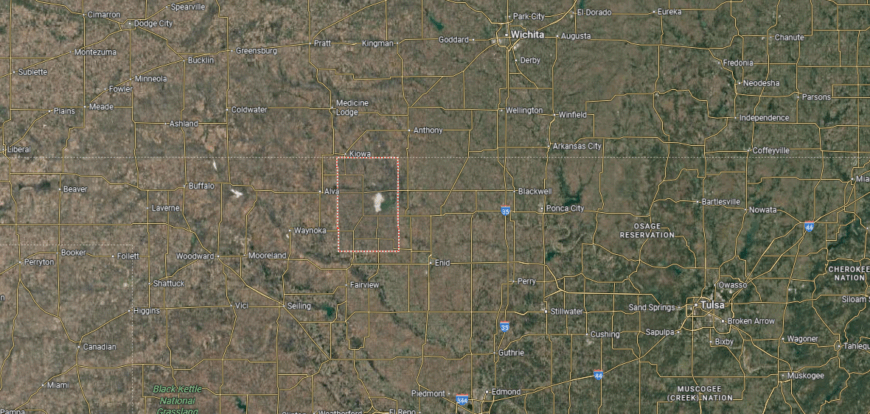
Where is Woods County?
Woods County is located in northwestern Oklahoma, bordered by Harper County to the west, Alfalfa County to the east, and Major County to the south. It spans about 1,290 square miles of High Plains and gently rolling prairie. Alva, the county seat, sits near the center along U.S. Highway 281 and serves as the region’s main community.
The county is crossed by U.S. Highways 64 and 281, creating links north into Kansas and south toward Enid and Woodward. Other communities include Waynoka to the south, known for its sand dunes, and Freedom near the Cimarron River. Woods County’s location highlights its role as a transportation and agricultural hub in northwestern Oklahoma.
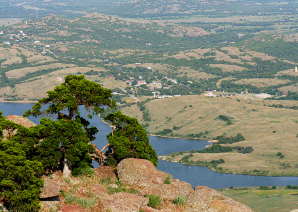
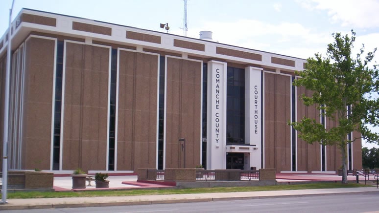
#14. Comanche County, Oklahoma
– Overall Rank: 354
– Population: 121,777
– Median household income: $57,150
– Median home value: $145,800 (55% own)
– Median rent: $903 (45% rent)
– Top public schools: Flower Mound Public School (grade A+), Bishop Public School (grade A), Elgin Middle School (grade A)
– Top private schools: Lawton Academy of Arts & Sciences (grade A+), Trinity Christian Academy (grade unavailable), Tincher Child Development Center (grade unavailable)
– Top places: Cache (grade B+), Lawton (grade B), Medicine Park (grade A minus)
🔥 Would you like to save this?
About
Comanche County, Oklahoma rests in the state’s southwest, where the Wichita Mountains rise from the plains to create a striking landscape. Lawton, the county seat, anchors the region as a center for commerce, culture, and education, while also serving as the gateway to nearby military and natural landmarks. The county’s history is tied to Native heritage, frontier settlement, and its role as a crossroads in southwestern Oklahoma.
Fort Sill, a major U.S. Army installation, shapes both the economy and community identity, alongside healthcare, education, and retail. Agriculture and energy production remain part of the county’s foundation, balanced by tourism connected to the Wichita Mountains Wildlife Refuge. Comanche County reflects a blend of heritage, natural beauty, and modern growth, giving it a unique place in Oklahoma’s story.
Where is Comanche County?
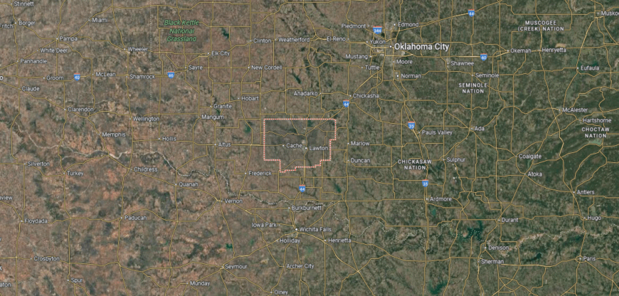
Comanche County is in southwestern Oklahoma, bordered by Caddo County to the north, Stephens County to the east, and Tillman County to the south. It spans about 1,084 square miles of prairie, rolling hills, and military land. Lawton, the county seat and largest city in southwestern Oklahoma, lies near the center along Interstate 44.
The county is crossed by I-44, which links it north to Oklahoma City and south to Wichita Falls, Texas. U.S. Highways 62 and 277 also serve the region, connecting smaller communities such as Cache, Fletcher, and Elgin. Comanche County’s location places it as a regional hub, home to both Fort Sill and key transportation routes in southwest Oklahoma.
#13. Logan County, Oklahoma
– Overall Rank: 340
– Population: 49,919
– Median household income: $80,565
– Median home value: $221,300 (87% own)
– Median rent: $869 (13% rent)
– Top public schools: Mulhall-Orlando Elementary School (grade A minus), Fogarty Elementary School (grade B+), Crescent High School (grade B)
– Top private schools:
– Top places: Guthrie (grade B), Cedar Valley (grade B+), Langston (grade B)
About
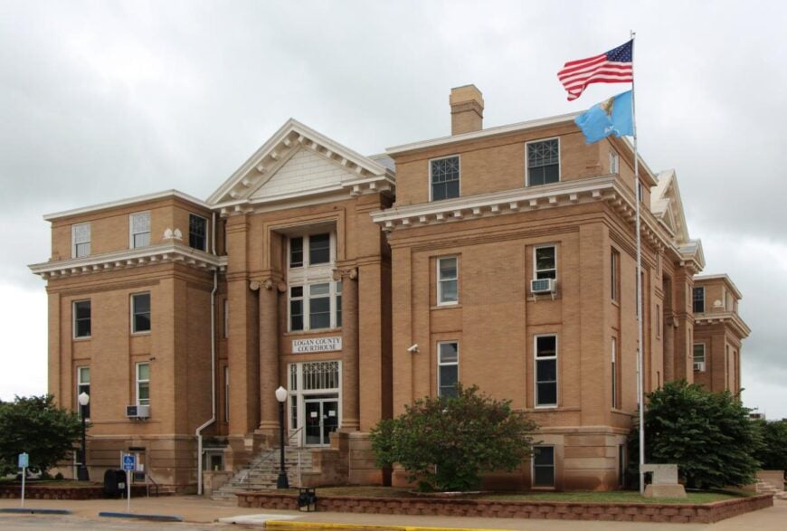
Logan County, Oklahoma sits in the north-central part of the state, where open plains and rolling hills carry both agricultural and historic significance. Guthrie, the county seat, was Oklahoma’s first state capital and today preserves that heritage with its Victorian architecture and thriving cultural scene. The county’s identity is shaped by its role in early statehood and its enduring small-town traditions.
Farming and ranching remain important, while manufacturing, retail, and tourism tied to Guthrie’s historic district add to the economy. Festivals, parades, and community events highlight the county’s civic pride and connection to its past. Logan County reflects a balance of heritage and progress, where history and modern life remain closely linked.
Where is Logan County?
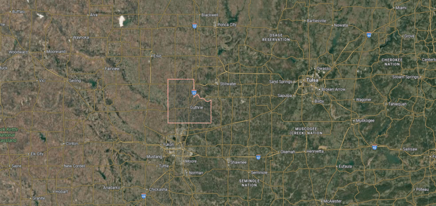
Logan County is in central Oklahoma, bordered by Payne County to the east, Kingfisher County to the west, and Oklahoma County to the south. It spans about 749 square miles of plains and gently rolling hills. Guthrie, the county seat and Oklahoma’s first territorial capital, sits near the center along Interstate 35.
I-35 serves as the primary north–south corridor, linking the county to Oklahoma City and Stillwater. U.S. Highways 77 and 33 also cross through, connecting smaller communities such as Crescent, Coyle, and Langston. Logan County’s location combines historic significance with strong highway access in the heart of central Oklahoma.
#12. Alfalfa County, Oklahoma
– Overall Rank: 321
– Population: 5,683
– Median household income: $75,028
– Median home value: $96,300 (80% own)
– Median rent: $654 (20% rent)
– Top public schools: Cherokee Elementary School (grade A), Cherokee Middle School (grade A), Burlington Elementary School (grade A)
– Top private schools:
– Top places: Jet (grade A), Burlington (grade A minus), Cherokee (grade B+)
About
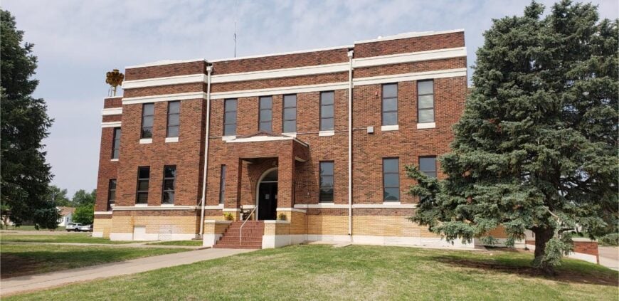
Alfalfa County, Oklahoma lies in the northwestern part of the state, where open prairies and farmland stretch beneath wide skies. Cherokee, the county seat, anchors civic life with its courthouse square and small-town traditions. The county’s history is tied to farming, ranching, and the steady resilience of rural communities.
Agriculture remains the backbone of the local economy, with wheat, cattle, and sorghum as major contributors. Energy production and small businesses add stability, supporting towns across the region. Alfalfa County reflects a rural identity where land, livelihood, and community pride continue to shape daily life.
Where is Alfalfa County?
Alfalfa County is located in north-central Oklahoma, bordered by Grant County to the east, Woods County to the west, and Major County to the south. It spans about 881 square miles of farmland, prairies, and salt plains. Cherokee, the county seat, lies near the center along U.S. Highway 64.
The county is served by U.S. Highways 64 and 281, which provide access east toward Enid and west into Woods County. Other communities include Helena to the southeast and Jet near the Great Salt Plains. Alfalfa County’s location highlights its role as a rural hub with connections to both agriculture and natural landmarks.
#11. Cherokee County, Oklahoma
– Overall Rank: 295
– Population: 47,412
– Median household income: $52,410
– Median home value: $144,600 (67% own)
– Median rent: $773 (33% rent)
– Top public schools: Keys Elementary School (grade A), Woodall Public School (grade A minus), Tahlequah Middle School (grade A minus)
– Top private schools: Shiloh Christian School (grade unavailable)
– Top places: Tahlequah (grade A minus), Park Hill (grade A minus), Woodall (grade A minus)
You may also like: Counties where children have the best opportunity for economic mobility in Oklahoma
About
Cherokee County, Oklahoma rests in the foothills of the Ozarks, where wooded hills and the Illinois River create a landscape rich in natural beauty. Tahlequah, the county seat, is also the capital of the Cherokee Nation and home to Northeastern State University, making it a center of cultural and educational life. The county’s history is deeply tied to Native heritage, settlement, and the traditions carried forward by its communities.
Tourism, education, and healthcare provide much of the county’s economic strength, while agriculture and small businesses remain part of its foundation. Festivals, river recreation, and cultural events highlight its diverse character and bring residents together. Cherokee County represents a place where history, identity, and progress remain closely connected.
Where is Cherokee County?
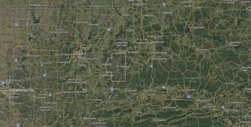
Cherokee County is in northeastern Oklahoma, bordered by Wagoner County to the west, Adair County to the east, and Muskogee County to the south. It covers about 776 square miles of hills, river valleys, and forested terrain in the foothills of the Ozarks. Tahlequah, the county seat, lies near the center along U.S. Highways 62 and 82.
The Illinois River runs through the eastern part of the county, while Fort Gibson Lake extends into its southwest corner. Other communities include Hulbert to the west and Keys to the south. Cherokee County’s location places it at the heart of the Cherokee Nation and provides access to both natural recreation areas and regional highways.
#10. Beaver County, Oklahoma
– Overall Rank: 275
– Population: 5,071
– Median household income: $62,981
– Median home value: $106,500 (78% own)
– Median rent: $838 (22% rent)
– Top public schools: Balko Elementary School (grade A), Beaver High School (grade A), Turpin High School (grade B)
– Top private schools:
– Top places: Beaver (grade B+), Turpin (grade B), Forgan (grade B minus)
About
Beaver County, Oklahoma lies in the Panhandle, where wide prairies and open skies define its rugged setting. Known as the “Cow Chip Throwing Capital of the World,” the county embraces its unique traditions alongside its strong agricultural base. Beaver, the county seat, serves as a hub of civic and community life for the surrounding rural areas.
Cattle ranching, wheat farming, and livestock production form the backbone of the economy, supported by small businesses that serve local needs. Community fairs, rodeos, and annual celebrations highlight pride in heritage and rural life. Beaver County reflects the enduring spirit of the Panhandle, where land, tradition, and resilience remain inseparable.
Where is Beaver County?
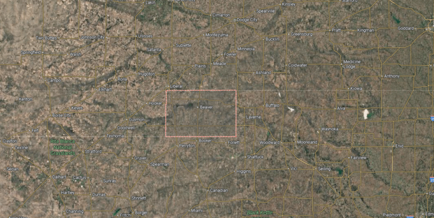
Beaver County is located in the Oklahoma Panhandle, bordered by Kansas to the north, Texas to the south, and Texas County to the west. It spans about 1,815 square miles of High Plains terrain. Beaver, the county seat, sits near the center along U.S. Highway 270.
The county is crossed by U.S. Highways 64, 83, and 270, giving it strong north–south and east–west routes. Other communities include Forgan near the Kansas line and Turpin close to the Texas border. Beaver County’s position in the Panhandle makes it a crossroads for agriculture and interstate travel between Oklahoma, Texas, and Kansas.
#9. Jackson County, Oklahoma
– Overall Rank: 264
– Population: 24,776
– Median household income: $60,954
– Median home value: $115,200 (61% own)
– Median rent: $842 (39% rent)
– Top public schools: Altus Early Childhood Center (grade A), L. Mendel Rivers Elementary School (grade A), Altus Primary School (grade A)
– Top private schools: Altus Christian Academy (grade unavailable)
– Top places: Altus (grade A minus), Eldorado (grade B+), East Duke (grade B)
About
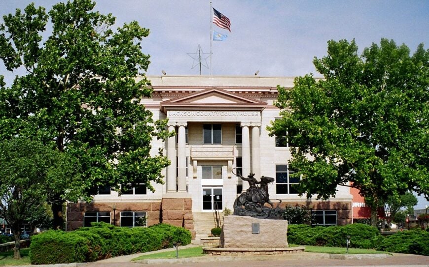
Jackson County, Oklahoma rests in the southwestern plains, where open farmland and the nearby Quartz Mountains shape both landscape and identity. Altus, the county seat, serves as a center for commerce, education, and military presence, anchored by Altus Air Force Base. The county’s history reflects a blend of agriculture, settlement, and the influence of the military in regional life.
Cotton and wheat production remain vital to the economy, joined by energy, manufacturing, and the operations tied to the Air Force base. Community events, fairs, and festivals highlight both rural traditions and civic pride. Jackson County represents a place where land, livelihood, and service continue to define its enduring character.
Where is Jackson County?
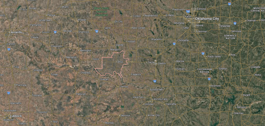
Jackson County is in southwestern Oklahoma, bordered by Greer County to the north, Tillman County to the east, and the Red River to the south, which marks the Texas state line. It covers about 804 square miles of plains and farmland. Altus, the county seat, lies near the center along U.S. Highways 62 and 283.
The county is served by U.S. Highways 62, 283, and 287, connecting it west to Childress, Texas, and east toward Lawton. Other communities include Olustee to the southwest, Blair to the north, and Eldorado near the Texas border. Jackson County’s location highlights its role as both an agricultural center and a border link between Oklahoma and Texas.
#8. Washington County, Oklahoma
– Overall Rank: 263
– Population: 52,579
– Median household income: $59,426
– Median home value: $151,000 (72% own)
– Median rent: $879 (28% rent)
– Top public schools: Wayside Elementary School (grade A minus), Central Middle School (grade A minus), Woodrow Wilson Elementary School (grade A minus)
– Top private schools: Wesleyan Christian School (grade A minus), St. John Catholic School (grade unavailable), PATHS TO INDEPENDENCE (grade unavailable)
– Top places: Bartlesville (grade A), Dewey (grade B minus), Vera (grade B minus)
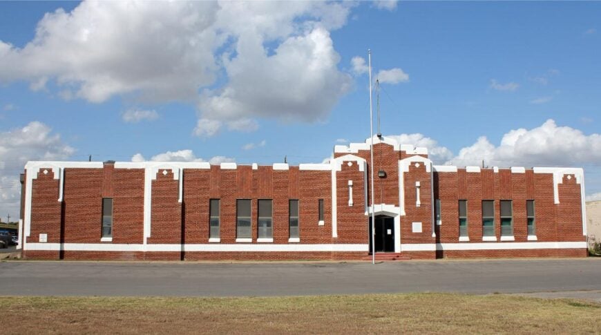
About
Washington County, Oklahoma sits in the northeastern part of the state, where rolling hills and tallgrass prairies frame both rural communities and growing towns. Bartlesville, the county seat, reflects a unique history shaped by the oil industry and the legacy of Phillips Petroleum, leaving an imprint on its culture and economy. The county blends small-town character with a tradition of innovation and resilience.
Energy and manufacturing remain important, but the economy has diversified into healthcare, education, and technology. Festivals, arts, and historic landmarks—such as the Price Tower designed by Frank Lloyd Wright—highlight the county’s cultural depth. Washington County stands as a place where heritage, industry, and creativity intersect, giving it a distinct identity in Oklahoma.
Where is Washington County?
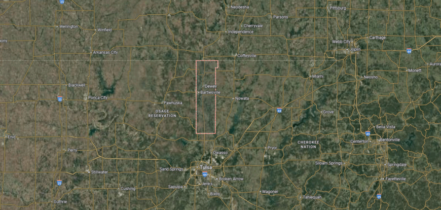
Washington County is in northeastern Oklahoma, bordered by Nowata County to the east, Osage County to the west, and the Kansas state line to the north. It covers about 424 square miles, making it one of the smaller counties in the state by area. Bartlesville, the county seat and largest city, lies near the center along U.S. Highway 75.
The county is crossed by U.S. Highway 75, which runs north–south to Tulsa and into Kansas, and U.S. Highway 60, which runs east–west through Bartlesville. Other communities include Dewey near the Kansas line and Ochelata to the south. Washington County’s location places it in the Tulsa metropolitan area while also serving as a gateway to southern Kansas.
#7. Custer County, Oklahoma
– Overall Rank: 230
– Population: 28,391
– Median household income: $58,669
– Median home value: $168,700 (65% own)
– Median rent: $732 (35% rent)
– Top public schools: Thomas Elementary School (grade A), Arapaho-Butler Elementary School (grade A minus), Weatherford East Elementary School (grade A minus)
– Top private schools: Corn Bible Academy (grade A), Western Oklahoma Christian School (grade unavailable)
– Top places: Weatherford (grade B+), Clinton (grade B+), Butler (grade B+)
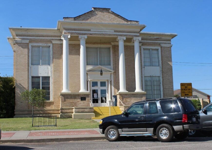
About
Custer County, Oklahoma lies in the western part of the state, where prairies and farmland stretch across the landscape. Weatherford and Clinton, its twin hubs, share roles in education, commerce, and community life—Weatherford as home to Southwestern Oklahoma State University and Clinton with its Route 66 heritage. The county’s history is tied to farming, settlement, and the growth of transportation routes.
Agriculture remains a foundation, while energy production, manufacturing, and higher education contribute strongly to the local economy. Museums, festivals, and community gatherings highlight both heritage and civic pride. Custer County reflects a blend of tradition and progress, sustained by land, industry, and education.
Where is Custer County?
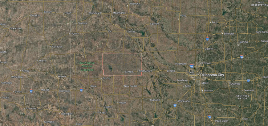
Custer County is in western Oklahoma, bordered by Dewey County to the north, Blaine County to the east, and Beckham County to the west. It spans about 1,002 square miles of plains and mixed farmland. Arapaho, the county seat, sits near the center, while Weatherford and Clinton are its largest cities along Interstate 40.
I-40 runs east–west across the county, linking it directly with Oklahoma City and Amarillo, Texas. U.S. Highways 183 and 281 provide north–south access through towns such as Custer City and Thomas. Custer County’s location makes it a key crossroads in western Oklahoma, combining interstate travel with regional agriculture.
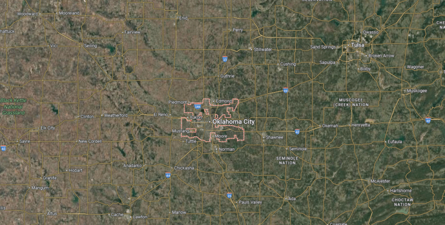
#6. Canadian County, Oklahoma
– Overall Rank: 221
– Population: 156,681
– Median household income: $82,364
– Median home value: $212,700 (76% own)
– Median rent: $1,129 (24% rent)
– Top public schools: Maple Public School (grade A+), Canyon Ridge Intermediate School (grade A), Piedmont Intermediate Elementary School (grade A)
– Top private schools: Southwest Covenant Schools (grade A minus), St. John Nepomuk Catholic School (grade unavailable), King’s Gate Christian School (grade unavailable)
– Top places: Yukon (grade A minus), Mustang (grade B+), El Reno (grade B)
You may also like: Counties with the highest rates of strokes in Oklahoma
About
Canadian County, Oklahoma rests on the central plains just west of Oklahoma City, where fertile farmland and expanding towns shape both history and growth. El Reno, the county seat, preserves its roots in railroads and agriculture, while communities like Yukon and Mustang reflect rapid suburban development. The county’s identity blends its rural foundation with the energy of modern expansion.
Wheat, cattle, and other agricultural products remain important, but the economy has broadened with manufacturing, retail, and industries tied to the Oklahoma City metro. Festivals, rodeos, and cultural events strengthen community bonds while celebrating local traditions. Canadian County represents a place where heritage and progress move side by side, rooted in land yet open to change.
Where is Canadian County?
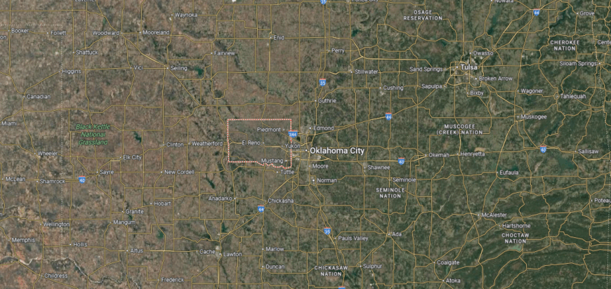
Canadian County is located in central Oklahoma, bordered by Kingfisher County to the north, Oklahoma County to the east, and Caddo County to the west. It covers about 905 square miles of prairie and rolling plains. El Reno, the county seat, sits near the center along Interstate 40, about 25 miles west of Oklahoma City.
The county is crossed by I-40 running east–west, U.S. Highway 81 running north–south, and the Kilpatrick Turnpike connecting to Oklahoma City. Yukon and Mustang, on the eastern side, serve as fast-growing suburban communities. Canadian County’s location ties it closely to the Oklahoma City metro while maintaining links westward into rural western Oklahoma.
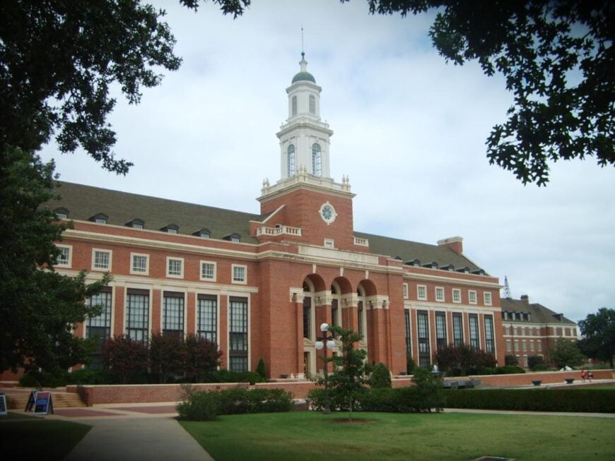
#5. Payne County, Oklahoma
– Overall Rank: 180
– Population: 82,058
– Median household income: $46,658
– Median home value: $196,100 (51% own)
– Median rent: $899 (49% rent)
– Top public schools: Stillwater High School (grade A), Richmond Elementary School (grade A), Westwood Elementary School (grade A)
– Top private schools: Covenant Community Christian School (grade unavailable), Sunnybrook Christian School (grade unavailable)
– Top places: Stillwater (grade A), Cushing (grade A minus), Mulhall (grade B)
About
Payne County, Oklahoma sits in the north-central part of the state, where prairies and farmland have long supported settlement and growth. Stillwater, the county seat, is home to Oklahoma State University, giving the area a strong educational and cultural identity. Other communities across the county reflect both rural traditions and ties to regional trade.
Agriculture and ranching remain important, but education, research, and technology tied to the university are central to the economy. Music, sports, and festivals add vibrancy to community life, drawing residents and visitors together. Payne County reflects a balance of heritage and innovation, where land and learning shape its character.
Where is Payne County?
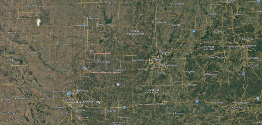
Payne County is in north-central Oklahoma, bordered by Noble County to the west, Pawnee County to the north, and Lincoln County to the south. It spans about 697 square miles of prairie and rolling terrain. Stillwater, the county seat and home to Oklahoma State University, lies near the center along U.S. Highway 177.
The county is served by U.S. Highways 177 and 64, along with State Highway 51, which connects west to Interstate 35. Other communities include Cushing in the southern part and Perkins to the southeast. Payne County’s location places it between Oklahoma City and Tulsa, with direct access to both urban centers.
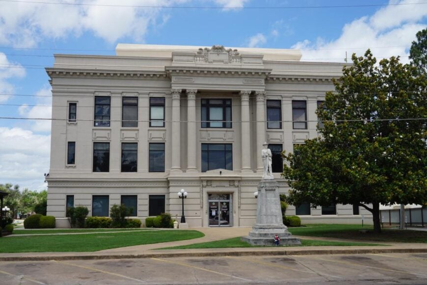
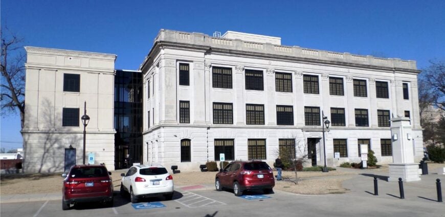
#4. Pontotoc County, Oklahoma
– Overall Rank: 145
– Population: 38,116
– Median household income: $59,457
– Median home value: $151,500 (66% own)
– Median rent: $847 (34% rent)
– Top public schools: Homer Elementary School (grade A), Latta Elementary School (grade A), Ada High School (grade A)
– Top private schools:
– Top places: Ada (grade A minus), Byng (grade A), Francis (grade B+)
About
Pontotoc County, Oklahoma lies in the south-central region of the state, where rolling hills and fertile ground support both farming and community life. Ada, the county seat, anchors the area with its role as a center of education, healthcare, and culture, while also serving as headquarters of the Chickasaw Nation. The county’s history is tied to Native heritage, early settlement, and the steady development of small towns.
Agriculture remains part of the local base, but the economy also depends on manufacturing, tribal enterprises, and services that support the region. Festivals, arts, and community events highlight cultural traditions and civic pride. Pontotoc County reflects a blend of Native history, rural heritage, and modern opportunity that continues to shape its identity.
Where is Pontotoc County?
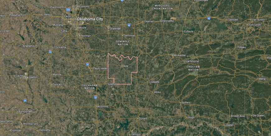
Pontotoc County is in south-central Oklahoma, bordered by Seminole County to the north, Johnston County to the south, and Hughes County to the east. It covers about 725 square miles of prairies, river valleys, and wooded hills. Ada, the county seat and largest city, is located near the center along State Highways 1, 3, and 19.
The county is crossed by State Highway 3, which links it west to Oklahoma City and east toward the Arkansas border. Other communities include Roff in the south, Stonewall to the southeast, and Byng just north of Ada. Pontotoc County’s location gives it strong regional access while maintaining its role as a local hub in south-central Oklahoma.
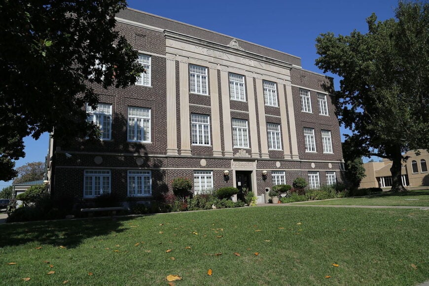
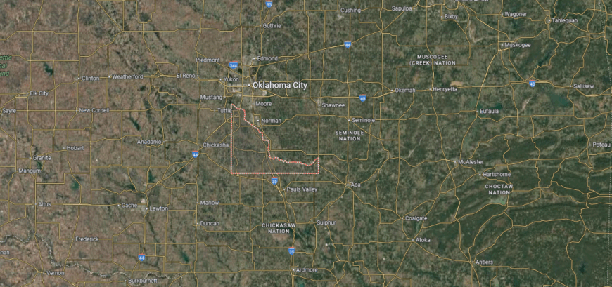
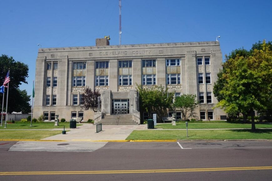
#3. Cleveland County, Oklahoma
– Overall Rank: 134
– Population: 295,060
– Median household income: $71,757
– Median home value: $203,900 (64% own)
– Median rent: $1,073 (36% rent)
– Top public schools: Robin Hill Public School (grade A), Fisher Elementary School (grade A), Brink Junior High School (grade A)
– Top private schools: Community Christian School (grade B), All Saints Catholic School (grade unavailable), Terra Verde Discovery School (grade unavailable)
– Top places: Norman (grade A), Moore (grade A minus), Noble (grade B)
About
Cleveland County, Oklahoma rests in the central part of the state, where prairies and growing towns reflect both rural heritage and urban expansion. Norman, the county seat, is home to the University of Oklahoma, shaping the county’s identity through education, research, and cultural life. Smaller communities add depth with traditions tied to farming, trade, and civic connection.
The economy is anchored by education and healthcare, supported by retail, technology, and industries tied to the Oklahoma City metro. Sports, festivals, and arts programs strengthen community life and highlight local pride. Cleveland County represents a place where history, learning, and modern growth come together in a dynamic way.
Where is Cleveland County?
Cleveland County is in central Oklahoma, bordered by Oklahoma County to the north, McClain County to the west, and Pottawatomie County to the east. It spans about 558 square miles, making it one of the smaller counties in the state by area but among the most populous. Norman, the county seat and home to the University of Oklahoma, lies near the center along Interstate 35.
I-35 runs north–south through the county, connecting Norman, Moore, and Noble with Oklahoma City to the north and Dallas to the south. U.S. Highways 77 and 62 also cross the area, adding east–west access. Cleveland County’s location makes it a key part of the Oklahoma City metropolitan region with strong educational and transportation ties.
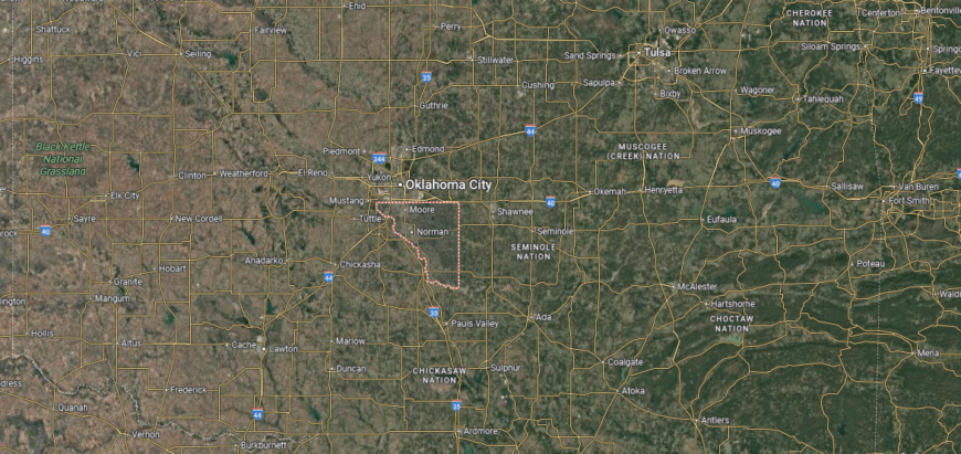
#2. Oklahoma County, Oklahoma
– Overall Rank: 105
– Population: 795,822
– Median household income: $62,505
– Median home value: $190,500 (59% own)
– Median rent: $1,008 (41% rent)
– Top public schools: Oklahoma School of Science and Mathematics (grade A+), Harding Charter Preparatory High School (grade A+), Oakdale Public School (grade A+)
– Top private schools: Casady School (grade A+), Heritage Hall (grade A+), Bishop McGuinness Catholic High School (grade A+)
– Top places: Edmond (grade A+), Oklahoma City (grade A minus), Nichols Hills (grade A minus)

About
Oklahoma County, Oklahoma sits at the heart of the state, where the prairies gave rise to its largest city and capital, Oklahoma City. The county’s history is tied to the Land Run of 1889, which opened the area to settlement and sparked rapid growth. Today, Oklahoma City serves as the cultural, political, and economic center of the region, while smaller towns contribute their own local traditions.
Energy, aviation, healthcare, and government drive much of the economy, alongside expanding sectors in technology and commerce. Museums, festivals, and sports events highlight the county’s cultural vibrancy and community pride. Oklahoma County reflects both the pioneering spirit of its origins and the modern energy of a fast-growing metropolitan hub.
Where is Oklahoma County?
Oklahoma County is in the center of the state, bordered by Logan County to the north, Cleveland County to the south, and Canadian County to the west. It covers about 718 square miles of prairie and urban development. Oklahoma City, the county seat and state capital, spans much of the county and serves as the largest metropolitan hub in Oklahoma.
The county is crossed by Interstates 35, 40, and 44, forming a major crossroads for both state and national travel. Other communities include Edmond to the north, Midwest City to the east, and Del City adjoining Oklahoma City. Oklahoma County’s central location and extensive highway network make it the political, economic, and transportation core of the state.
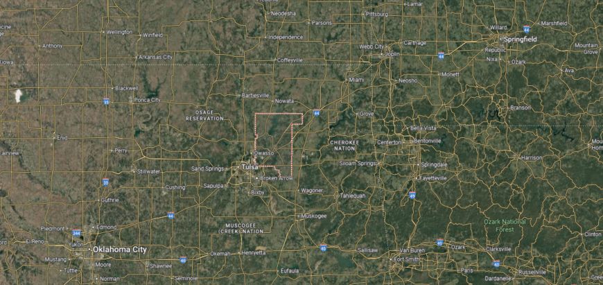
#1. Tulsa County, Oklahoma
– Overall Rank: 98
– Population: 668,923
– Median household income: $65,229
– Median home value: $196,300 (60% own)
– Median rent: $1,002 (40% rent)
– Top public schools: Booker T. Washington High School (grade A+), Deborah Brown Community School (grade A+), Jenks High School (grade A+)
– Top private schools: Holland Hall (grade A+), Cascia Hall Preparatory School (grade A+), Peace Academy (grade A+)
– Top places: Jenks (grade A+), Bixby (grade A), Broken Arrow (grade A)
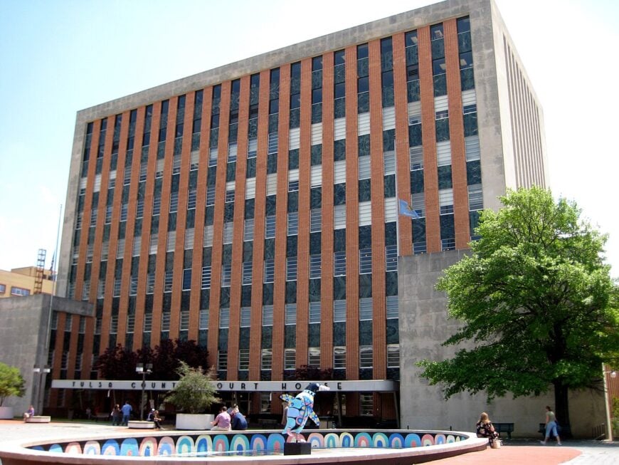
About
Tulsa County, Oklahoma lies in the northeastern part of the state, where the Arkansas River winds through wooded hills and wide plains. Tulsa, the county seat, grew out of oil booms in the early 20th century and developed into a cultural and economic center of the region. Smaller towns within the county add layers of community life rooted in both rural and suburban traditions.
Energy and aerospace remain vital to the economy, while healthcare, technology, and finance have expanded the county’s reach. Festivals, arts, and music highlight Tulsa’s reputation as a hub of culture and creativity. Tulsa County represents a place where historic industry and modern innovation work side by side, shaping a dynamic identity.
Where is Tulsa County?
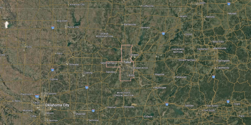
Tulsa County is in northeastern Oklahoma, bordered by Osage County to the west, Rogers County to the north and east, and Okmulgee County to the south. It spans about 587 square miles, much of it within the Arkansas River Valley. Tulsa, the county seat and second-largest city in Oklahoma, sits near the center along the river.
The county is crossed by Interstates 44, 244, and 244/64 (the Broken Arrow Expressway), as well as U.S. Highways 64, 75, and 169, making it one of the most accessible in the state. Other communities include Broken Arrow, Owasso, and Sand Springs, each tied into the Tulsa metropolitan area. Tulsa County’s location places it at the heart of Green Country, serving as a major economic and transportation hub in Oklahoma.
This story features data reporting and writing by Elena Cox and is part of a series utilizing data automation across 50 states.
You may also like: Best counties to raise a family in Oklahoma
By Stacker