Would you like to save this?

Best counties to live in North Dakota
More counties in the United States experienced population growth in the last year, according to the latest Census data, even as pandemic-related moving trends begin to normalize.
Counties in the South continued to experience growth, particularly in Florida, where 96% of its 67 counties gained new residents. Polk County, Florida, a suburb of Orlando, added the most, with 26,000 people moving there in 2023.
Meanwhile, counties in the Midwest and Northeast continued to lose population, but at slower rates than the year before. Some of the biggest losses were in counties home to large cities, including Cook County, Illinois (home of Chicago) and the boroughs of Brooklyn and Queens in New York.
Many counties are experiencing growth due to their job opportunities, education, or relatively affordable housing costs. Others are favored for their historic or well-designed downtowns or access to cultural opportunities.
Stacker compiled a list of the best counties to live in North Dakota using rankings from Niche. Niche ranks counties by various factors including public schools, educational attainment, cost of living, and housing.
Keep reading to see if your county made the list.
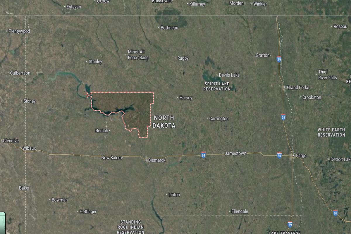
#24. McKenzie County, North Dakota
– Overall Rank: Not ranked
– Population: 14,081
– Median household income: $83,813
– Median home value: $330,200 (56% own)
– Median rent: $1,192 (44% rent)
– Top public schools: East Fairview Elementary School (grade A), Badlands Elementary School (grade C+), Fox Hills Elementary School (grade C+)
– Top private schools: Johnson Corners Christian Academy (grade B+)
– Top places: Yellowstone Township (grade B minus), Watford City (grade B minus), Mandaree (grade C)
About
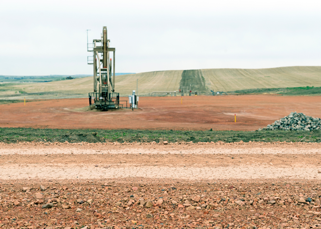
McKenzie County is shaped by wide prairies, rugged badlands, and a strong connection to energy and agriculture. The area has experienced growth through oil development while maintaining its deep ranching and farming traditions. Its landscape and economy reflect both natural beauty and industrial resilience.
Residents value independence, community pride, and a lifestyle rooted in hard work and the outdoors. Local events, rodeos, and school activities strengthen social ties and celebrate heritage. McKenzie County offers a bold, enduring way of life shaped by land, resourcefulness, and tradition.
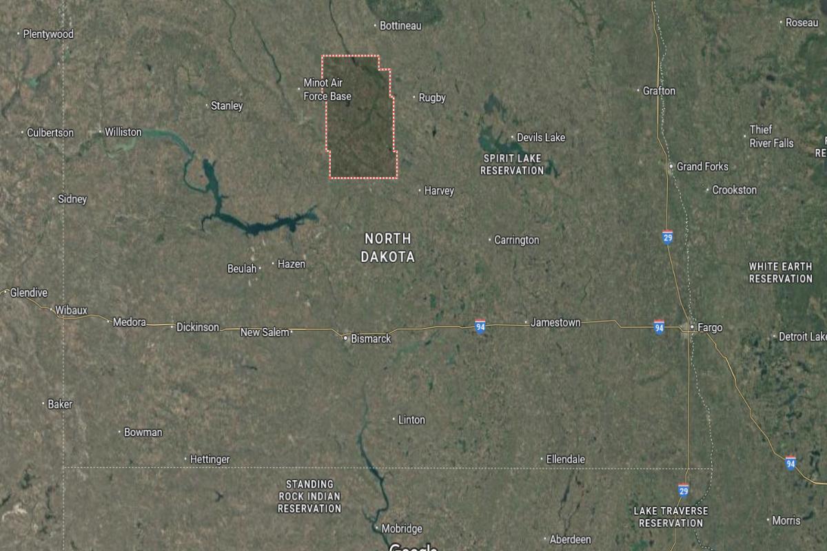
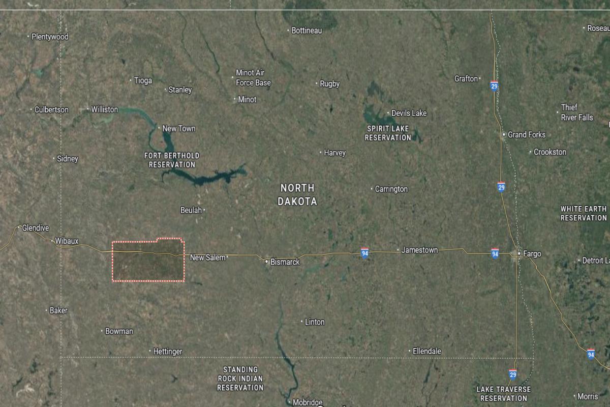
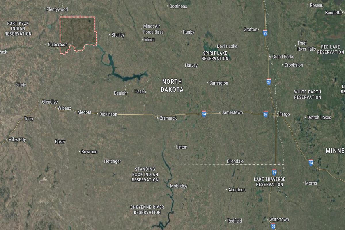
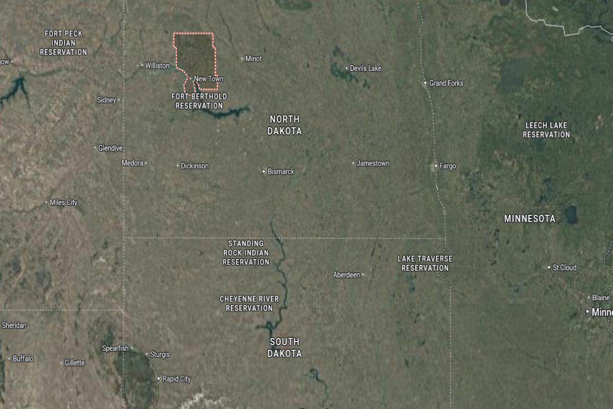
Where is McKenzie County?
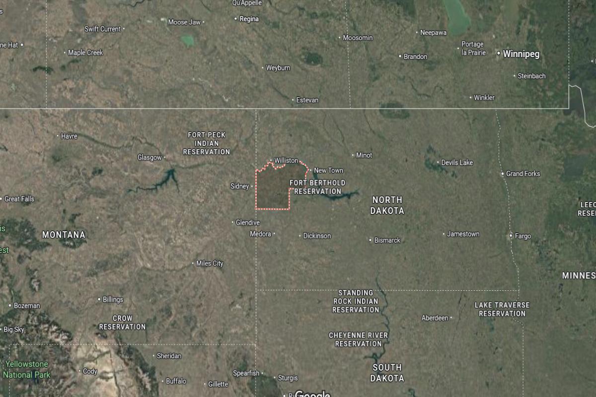
McKenzie County is located in western North Dakota, about 185 miles northwest of Bismarck and 80 miles northeast of the Montana border. The county seat, Watford City, lies roughly 50 miles southeast of Williston and 70 miles north of Dickinson. It is part of the Bakken oil region and includes portions of the Little Missouri National Grassland.
The area is approximately 60 miles west of Lake Sakakawea and 45 miles east of the Theodore Roosevelt National Park’s north unit. U.S. Route 85 runs through the county, connecting it to key oil and transport hubs. McKenzie County is also about 90 miles south of the Canadian border.
Would you like to save this?
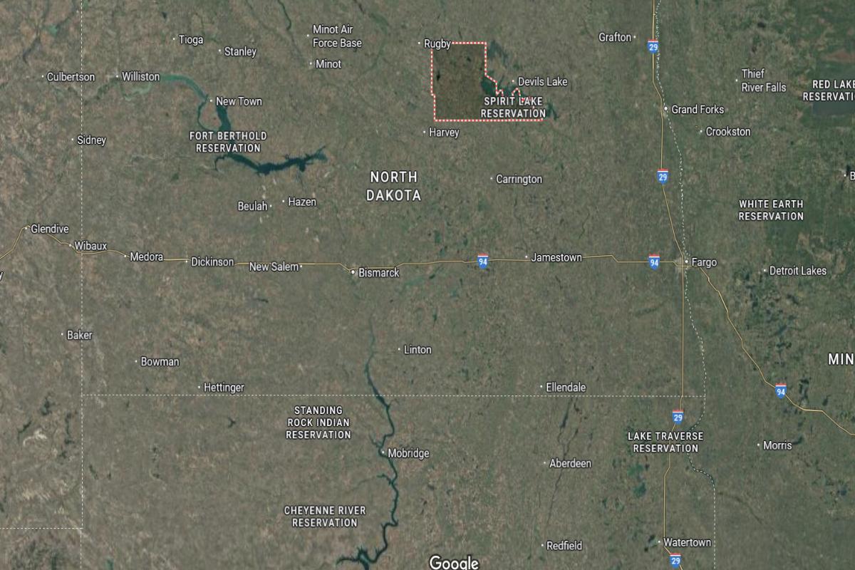
#23. Rolette County, North Dakota
– Overall Rank: Not ranked
– Population: 12,292
– Median household income: $53,806
– Median home value: $90,200 (66% own)
– Median rent: $482 (34% rent)
– Top public schools: Mt. Pleasant High School (grade B), Rolette Elementary School (grade B), Rolette High School (grade B minus)
– Top private schools: St. Ann’s Catholic School (grade unavailable)
– Top places: Rolette (grade A minus), Rolla (grade B), St. John (grade C+)
About
Rolette County is known for its rich cultural heritage, strong tribal communities, and a deep sense of identity rooted in tradition and land. Rolling prairies and forested areas shape a landscape that supports farming, crafts, and community-centered living. The area reflects resilience, history, and spiritual connection.
Residents place high value on family, cultural preservation, and communal support. Ceremonies, gatherings, and youth programs play a vital role in daily life and generational continuity. Rolette County offers a meaningful way of life guided by heritage, unity, and respect for the land.
Where is Rolette County?
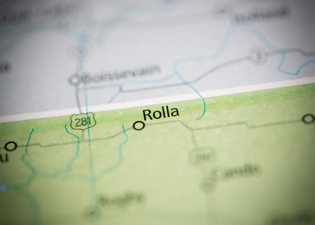
Rolette County is located in north-central North Dakota, directly along the Canadian border, about 125 miles north of Bismarck. The county seat, Rolla, is situated roughly 25 miles west of Rugby and 10 miles south of the border with Manitoba. It lies within the Turtle Mountain region, a mix of forested hills and prairie.
The area is approximately 30 miles northeast of the International Peace Garden and 35 miles east of Bottineau. U.S. Route 281 and State Route 5 provide access across the county. Rolette County is also around 85 miles northwest of Grand Forks.
#22. McHenry County, North Dakota
– Overall Rank: Not ranked
– Population: 5,326
– Median household income: $78,071
– Median home value: $136,600 (82% own)
– Median rent: $753 (18% rent)
– Top public schools: Velva High School (grade B), Anamoose Elementary School (grade B), Velva Elementary School (grade B)
– Top private schools:
– Top places: Towner (grade B), Velva (grade B), Deering (grade B minus)
About
McHenry County is shaped by its agricultural roots, open landscapes, and small-town character that emphasizes simplicity and hard work. Wheat fields, pastures, and rural communities reflect a way of life tied closely to the land. Farming and local traditions form the backbone of daily routines.
Residents value independence, family, and community cooperation. Seasonal events, church gatherings, and local fairs reinforce strong social ties. McHenry County offers a peaceful, grounded lifestyle built on resilience, heritage, and rural pride.
Where is McHenry County?
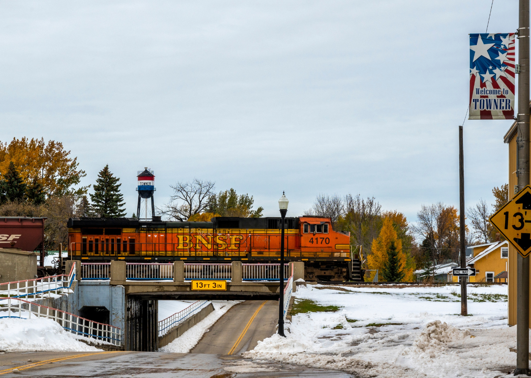
McHenry County is located in north-central North Dakota, about 45 miles southeast of Minot and 115 miles northeast of Bismarck. The county seat, Towner, is roughly 40 miles southwest of Rugby and 90 miles northwest of Devils Lake. It sits within a mix of prairie and farmland in the Drift Prairie region.
The area is approximately 65 miles west of the Turtle Mountains and 80 miles south of the Canadian border. U.S. Route 2 and State Route 14 intersect the county, offering regional connectivity. McHenry County is also about 70 miles north of Jamestown.
#21. Ransom County, North Dakota
– Overall Rank: Not ranked
– Population: 5,663
– Median household income: $71,462
– Median home value: $145,900 (74% own)
– Median rent: $840 (26% rent)
– Top public schools: Lisbon Elementary School (grade B), Lisbon Middle School (grade B), Lisbon High School (grade B)
– Top private schools:
– Top places: Aliceton Township (grade B), Lisbon (grade B), Enderlin (grade B minus)
About
Ransom County is rooted in agriculture, with vast fields, quiet towns, and a lifestyle centered on farming and community values. The landscape supports crops, livestock, and a deep connection to seasonal rhythms. Generational farms and local businesses reflect a tradition of hard work and pride in place.
Residents foster close relationships through school events, church gatherings, and county fairs. The community spirit is strong, marked by neighborly support and shared history. Ransom County offers a steady, rural way of life grounded in heritage and mutual respect.
Where is Ransom County?
Ransom County is located in southeastern North Dakota, about 65 miles southwest of Fargo and 75 miles southeast of Jamestown. The county seat, Lisbon, is situated roughly 25 miles south of Valley City and 40 miles west of Wahpeton. It lies within the Sheyenne River Valley, an area of rolling hills and farmland.
The area is approximately 90 miles northeast of Aberdeen, South Dakota and 55 miles east of Ellendale. State Routes 27 and 32 run through the county, providing local and regional access. Ransom County is also about 45 miles north of the South Dakota border.
#20. Mercer County, North Dakota
– Overall Rank: Not ranked
– Population: 8,366
– Median household income: $82,155
– Median home value: $192,000 (84% own)
– Median rent: $1,039 (16% rent)
– Top public schools: Hazen High School (grade B), Hazen Elementary School (grade B), Hazen Middle-High School (grade C)
– Top private schools:
– Top places: Beulah (grade B minus), Hazen (grade A minus), Stanton (grade B minus)
About
Mercer County is defined by its blend of agriculture, energy production, and strong rural traditions. Rolling plains, coal mines, and power plants reflect a hardworking community rooted in both natural resources and farming. Small towns and open spaces create a lifestyle centered on resilience and self-reliance.
Residents value family, faith, and a close connection to the land and one another. Community events, school activities, and local gatherings foster unity and pride. Mercer County offers a balanced, grounded way of life shaped by industry, tradition, and strong community bonds.
Where is Mercer County?
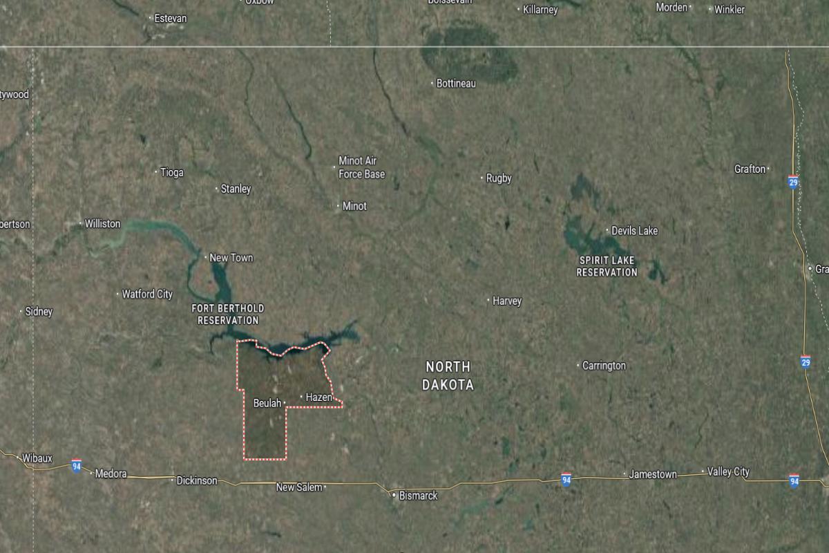
Mercer County is located in west-central North Dakota, about 60 miles northwest of Bismarck and 85 miles southeast of Williston. The county seat, Stanton, is roughly 25 miles west of Washburn and 30 miles northeast of Beulah. It lies near the Missouri River and Lake Sakakawea, offering access to water recreation and energy resources.
The area is approximately 50 miles north of Dickinson and 40 miles south of Garrison. State Routes 200 and 31 provide transportation through the county. Mercer County is also around 70 miles east of Killdeer in Dunn County.
#19. McLean County, North Dakota
– Overall Rank: Not ranked
– Population: 9,781
– Median household income: $80,556
– Median home value: $222,100 (83% own)
– Median rent: $766 (17% rent)
– Top public schools: Wilton Elementary School (grade A minus), Bob Callies Elementary School (grade B+), Washburn Elementary School (grade B+)
– Top private schools:
– Top places: Washburn (grade B), Garrison (grade B), Turtle Lake (grade B)
About
McLean County is shaped by its expansive prairies, agricultural economy, and strong ties to energy and water resources. Farming, ranching, and power generation play key roles in both daily life and regional identity. Small communities thrive on a mix of tradition, industry, and natural beauty.
Residents value independence, hard work, and the steady rhythms of rural living. Local fairs, school events, and seasonal activities bring people together and reinforce strong community bonds. McLean County offers a grounded, self-sufficient lifestyle rooted in land, heritage, and shared purpose.
Where is McLean County?
Would you like to save this?
McLean County is located in central North Dakota, about 40 miles north of Bismarck and 100 miles southeast of Minot. The county seat, Washburn, sits along the Missouri River and is approximately 25 miles south of Garrison. It lies in a region of rolling plains, near the eastern edge of Lake Sakakawea.
The area is about 65 miles west of Jamestown and 85 miles east of Dickinson. U.S. Route 83 runs through the county, connecting it to major cities in the state. McLean County is also roughly 90 miles south of the Canadian border.
#18. Stark County, North Dakota
– Overall Rank: 1,389
– Population: 32,989
– Median household income: $78,734
– Median home value: $255,200 (64% own)
– Median rent: $988 (36% rent)
– Top public schools: Taylor-Richardton Elementary School (grade B), Lincoln Elementary School (grade B minus), Roosevelt Elementary School (grade B minus)
– Top private schools: Trinity Junior High & High School (grade A), Hope Christian Academy (grade B minus), Trinity Elementary School West (grade unavailable)
– Top places: Dickinson (grade B), Taylor (grade A minus), South Heart (grade B)
About
Stark County is defined by its blend of agriculture, energy development, and growing commerce that supports a vibrant, hardworking population. The landscape features rolling plains and productive farmland alongside industrial activity tied to oil and construction. Its communities reflect both tradition and forward-looking growth.
Residents value resilience, entrepreneurship, and strong family ties that span generations. Events, local businesses, and civic involvement foster a sense of unity and pride. Stark County offers a dynamic lifestyle grounded in opportunity, heritage, and regional strength.
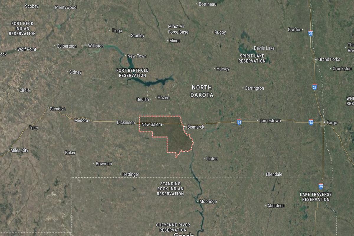
Where is Stark County?
Stark County is located in southwestern North Dakota, about 100 miles west of Bismarck and 45 miles east of the Montana border. The county seat, Dickinson, is situated approximately 70 miles south of Watford City and 60 miles west of Glen Ullin. It lies along Interstate 94 in the heart of the state’s oil and agriculture region.
The area is around 80 miles northeast of Bowman and 50 miles south of Lake Sakakawea. U.S. Route 85 also passes through the county, connecting it north to Williston and south to South Dakota. Stark County is approximately 90 miles east of the North Dakota–Montana–South Dakota tri-state border.
#17. Stutsman County, North Dakota
– Overall Rank: 1,264
– Population: 21,609
– Median household income: $59,167
– Median home value: $191,000 (65% own)
– Median rent: $746 (35% rent)
– Top public schools: William S. Gussner Elementary School (grade A minus), Pingree-Buchanan Elementary School (grade B+), Louis L’Amour Elementary School (grade B+)
– Top private schools: St. John’s Academy (grade unavailable), Anne Carlsen Center (grade unavailable), Hillcrest Seventh-day Adventist Elementary School (grade unavailable)
– Top places: Jamestown (grade B), Spiritwood Lake (grade B+), Bloom Township (grade B)
About
Stutsman County is characterized by its agricultural landscape, prairie scenery, and a strong commitment to education and civic life. Farming and ranching shape much of the local economy, supported by a network of small towns and rural communities. The area blends traditional values with growing economic and cultural opportunities.
Residents take pride in their heritage, emphasizing family, community service, and resilience. Local fairs, sporting events, and festivals bring people together and celebrate shared identity. Stutsman County offers a steady, rooted way of life shaped by hard work, unity, and rural pride.
Where is Stutsman County?
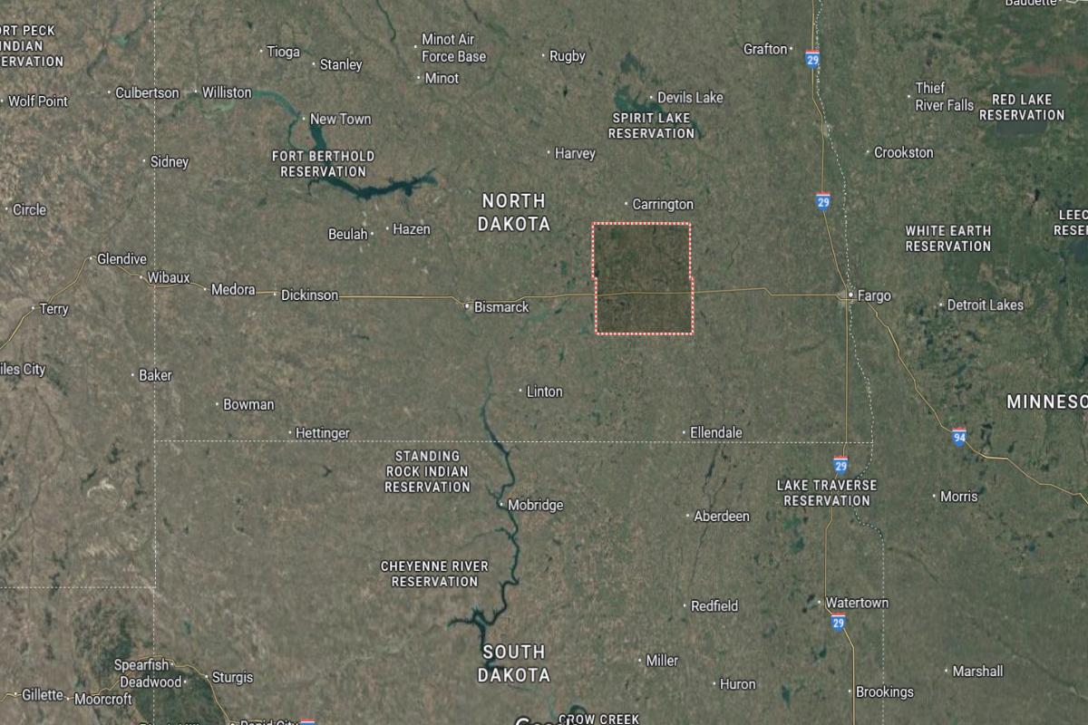
Stutsman County is located in southeastern North Dakota, about 95 miles west of Fargo and 100 miles east of Bismarck. The county seat, Jamestown, is roughly 40 miles east of Carrington and 70 miles north of Ellendale. It lies along Interstate 94, making it a key transportation hub in the region.
The area is approximately 85 miles south of Devils Lake and 60 miles west of Valley City. U.S. Route 281 also runs through the county, connecting it north to Minnewaukan and south to South Dakota. Stutsman County is around 90 miles northwest of Wahpeton near the Minnesota border.
#16. Walsh County, North Dakota
– Overall Rank: 1,235
– Population: 10,553
– Median household income: $68,082
– Median home value: $111,700 (78% own)
– Median rent: $695 (22% rent)
– Top public schools: Valley-Edinburg Elementary School – Hoople (grade A), Central Valley Elementary School (grade A minus), Central Valley High School (grade B)
– Top private schools:
– Top places: Grafton (grade B+), Edinburg (grade A minus), Glenwood Township (grade B+)
About
Walsh County is deeply rooted in agriculture, with fertile fields, historic farms, and small towns that reflect a strong rural tradition. The community thrives on crop production, especially potatoes and grains, supported by generations of family-run operations. Scenic countryside and a quiet pace of life define the local character.
Residents value faith, hard work, and the strength of close-knit relationships. Seasonal festivals, church events, and school activities bring people together and reinforce community bonds. Walsh County offers a peaceful, enduring lifestyle shaped by the land, tradition, and shared values.
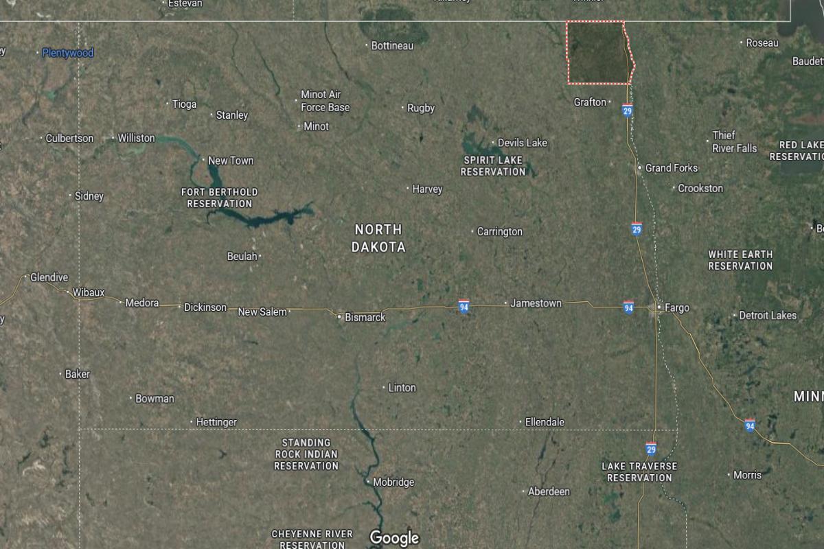
Where is Walsh County?
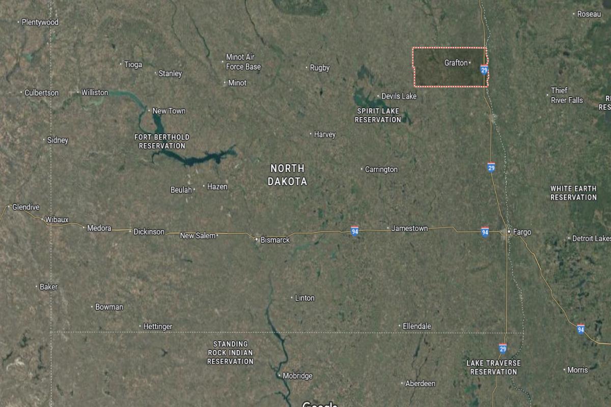
Walsh County is located in northeastern North Dakota, about 40 miles west of Grand Forks and 35 miles south of the Canadian border. The county seat, Grafton, is situated roughly 20 miles west of Drayton and 25 miles north of Park River. It lies in the Red River Valley, a fertile agricultural region near the Minnesota state line.
The area is approximately 75 miles north of Valley City and 50 miles northeast of Devils Lake. U.S. Route 81 and State Route 17 run through the county, providing regional connectivity. Walsh County is also about 60 miles east of Langdon in Cavalier County.
#15. Morton County, North Dakota
– Overall Rank: 1,116
– Population: 33,192
– Median household income: $79,555
– Median home value: $247,200 (73% own)
– Median rent: $973 (27% rent)
– Top public schools: Hebron Elementary School (grade B+), Red Trail Elementary School (grade B), Glen Ullin High School (grade B)
– Top private schools: St. Joseph Elementary School (grade unavailable), Christ the King Elementary School (grade unavailable)
– Top places: Mandan (grade B), Hebron (grade B+), Flasher (grade B)
About
Morton County blends agricultural strength with a growing economy supported by ranching, energy, and local commerce. Rolling hills, open plains, and strong community infrastructure shape its rural yet forward-moving identity. Historic traditions and modern development coexist throughout its towns and countryside.
Residents value independence, family ties, and active participation in community life. Local events, school programs, and civic pride foster a strong sense of belonging. Morton County offers a balanced lifestyle rooted in heritage, resilience, and steady progress.
Where is Morton County?
Morton County is located in south-central North Dakota, directly across the Missouri River from Bismarck. The county seat, Mandan, is about 5 miles west of Bismarck and 80 miles east of Dickinson. It lies along Interstate 94 and serves as part of the Bismarck-Mandan metropolitan area.
The area is approximately 60 miles north of the South Dakota border and 70 miles southeast of Beulah. U.S. Route 83 and State Route 6 provide access through the county. Morton County is also around 90 miles southwest of Jamestown.
#14. Benson County, North Dakota
– Overall Rank: 1,092
– Population: 5,960
– Median household income: $63,220
– Median home value: $79,300 (72% own)
– Median rent: $563 (28% rent)
– Top public schools: Leeds Elementary School (grade B+), Maddock Elementary School (grade B), Maddock High School (grade B minus)
– Top private schools:
– Top places: Leeds (grade B+), Maddock (grade B minus), Minnewaukan (grade B minus)
About
Benson County is shaped by its wide-open landscapes, agricultural traditions, and strong cultural roots. Farming, ranching, and community events form the backbone of daily life, supported by generations of hardworking families. The county also reflects a deep respect for tribal heritage and natural surroundings.
Residents value resilience, family, and a close-knit community spirit. Local festivals, school programs, and cultural gatherings bring people together and strengthen social ties. Benson County offers a quiet, grounded lifestyle rooted in heritage, cooperation, and connection to the land.
Where is Benson County?
Benson County is located in northeastern North Dakota, about 85 miles west of Grand Forks and 60 miles east of Rugby. The county seat, Minnewaukan, sits on the southern shore of Devils Lake and is roughly 95 miles north of Jamestown. It lies within a region of wetlands and rolling plains, influenced by nearby lake systems.
The area is approximately 70 miles south of the Canadian border and 50 miles northeast of Carrington. U.S. Route 2 and State Route 19 provide transportation access through the county. Benson County is also about 45 miles northwest of New Rockford.
#13. Ramsey County, North Dakota
– Overall Rank: 1,080
– Population: 11,613
– Median household income: $61,490
– Median home value: $193,300 (62% own)
– Median rent: $663 (38% rent)
– Top public schools: Sweetwater Elementary School (grade B+), Minnie H. Kindergarten Center (grade B minus), Central Middle School (grade C+)
– Top private schools: St. Joseph School (grade unavailable)
– Top places: Devils Lake (grade B minus), Edmore (grade B+), North Creel Township (grade B+)
About
Ramsey County blends agricultural productivity with a vibrant sense of community and regional pride. The landscape features open fields, lakes, and small towns that reflect both natural beauty and rural resilience. Farming, local businesses, and education are central to its way of life.
Residents value hard work, family traditions, and strong civic involvement. Seasonal events, school activities, and recreational opportunities foster unity and connection. Ramsey County offers a balanced lifestyle grounded in heritage, community spirit, and the rhythms of the land.
Where is Ramsey County?
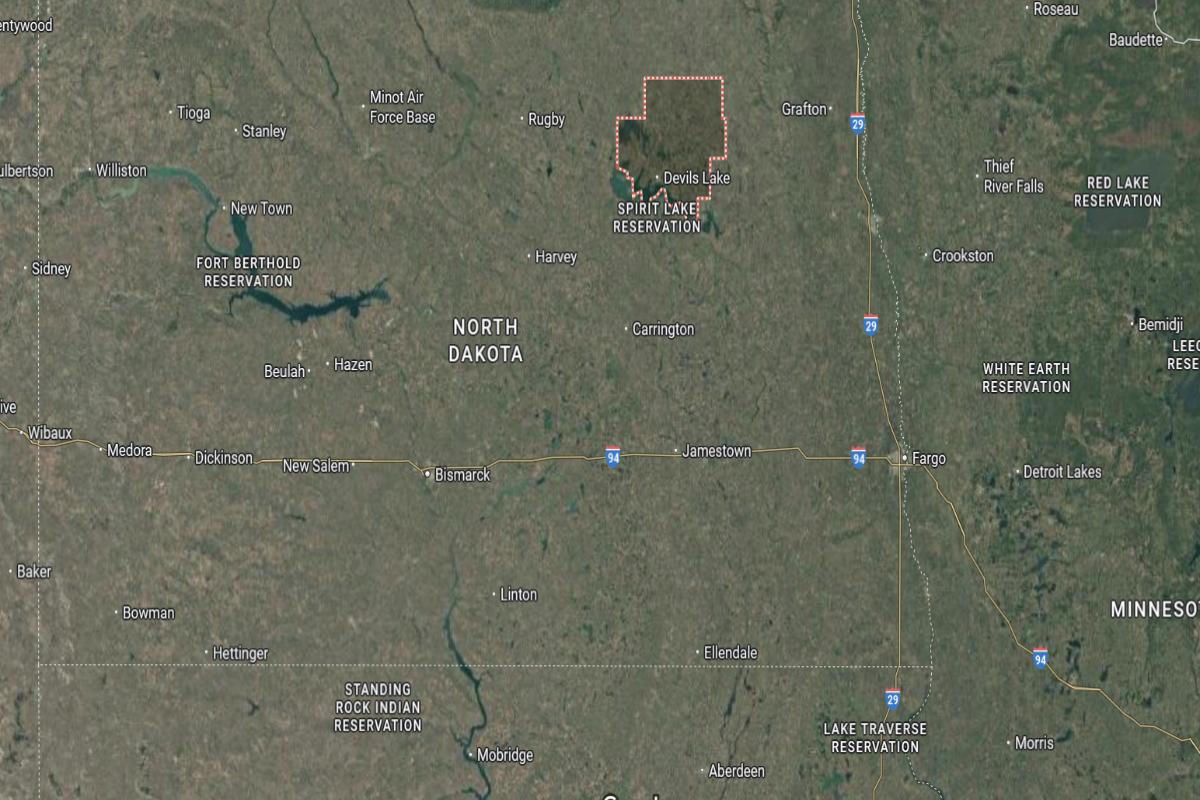
Ramsey County is located in northeastern North Dakota, about 90 miles west of Grand Forks and 60 miles east of Rugby. The county seat, Devils Lake, is situated on the southern edge of Devils Lake and lies roughly 95 miles north of Jamestown. It is a key regional center in the northern part of the state.
The area is approximately 75 miles south of the Canadian border and 50 miles northeast of Minnewaukan. U.S. Route 2 and State Route 20 provide major access through the county. Ramsey County is also about 45 miles northwest of Lakota in Nelson County.
#12. Williams County, North Dakota
– Overall Rank: 1,045
– Population: 39,076
– Median household income: $86,139
– Median home value: $255,000 (54% own)
– Median rent: $1,097 (46% rent)
– Top public schools: Grenora Elementary School (grade B), Tioga High School (grade B minus), Ray Elementary School (grade B minus)
– Top private schools: Williston Trinity Christian School (grade C+), St. Josephs Elementary School (grade unavailable)
– Top places: Williston (grade B), Williston Township (grade A), Grenora (grade B+)
About
Williams County is defined by its energy-driven growth, agricultural roots, and expansive prairie landscapes. The area has experienced rapid development through oil production while maintaining ties to farming and ranching traditions. Communities balance industry with small-town character and open space.
Residents value opportunity, resilience, and a strong work ethic shaped by both modern change and deep-rooted heritage. Local events, schools, and outdoor life create a strong sense of place and belonging. Williams County offers a dynamic, grounded lifestyle built on progress, tradition, and connection to the land.
Where is Williams County?
Williams County is located in northwestern North Dakota, about 225 miles northwest of Bismarck and 15 miles east of the Montana border. The county seat, Williston, lies roughly 60 miles north of Watford City and 70 miles west of Crosby. It is a central part of the Bakken oil region and sits near the confluence of the Missouri and Yellowstone Rivers.
The area is approximately 50 miles south of the Canadian border and 90 miles northwest of Dickinson. U.S. Route 2 and U.S. Route 85 intersect in Williston, providing major east-west and north-south access. Williams County is also about 80 miles northeast of Sidney, Montana.
#11. Ward County, North Dakota
– Overall Rank: 997
– Population: 69,532
– Median household income: $78,143
– Median home value: $249,800 (61% own)
– Median rent: $1,005 (39% rent)
– Top public schools: Sawyer Elementary School (grade A+), Memorial Middle School (grade A minus), North Plains Elementary School (grade B+)
– Top private schools: Bishop Ryan Catholic School (grade B+), Our Redeemer’s Christian School (grade B minus), Dakota Memorial High School (grade unavailable)
– Top places: Minot (grade B), Berthold (grade B+), Sawyer (grade B+)
About
Ward County blends urban development with rural heritage, offering a mix of modern infrastructure and agricultural tradition. The area supports a strong economy through military presence, commerce, and farming, creating a diverse and resilient community. Rolling plains and active neighborhoods contribute to a balanced, thriving environment.
Residents value service, education, and a strong sense of community rooted in both progress and tradition. Local festivals, civic events, and recreational opportunities bring people together year-round. Ward County offers a dynamic yet grounded lifestyle shaped by growth, heritage, and shared pride.
Where is Ward County?
Ward County is located in north-central North Dakota, about 110 miles north of Bismarck and 60 miles south of the Canadian border. The county seat, Minot, is situated approximately 55 miles west of Rugby and 70 miles east of Stanley. It lies along U.S. Route 2 and serves as a major regional hub.
The area is around 90 miles northeast of Williston and 80 miles northwest of Devils Lake. U.S. Route 52 and State Route 83 provide additional access through the county. Ward County is also about 65 miles north of Garrison near Lake Sakakawea.
#10. Mountrail County, North Dakota
– Overall Rank: 877
– Population: 9,648
– Median household income: $81,886
– Median home value: $205,000 (61% own)
– Median rent: $929 (39% rent)
– Top public schools: North Shore Plaza Elementary School (grade B), North Shore Plaza High School (grade B), Stanley High School (grade B minus)
– Top private schools:
– Top places: Osborn Township (grade B+), Plaza (grade B), New Town (grade B)
About
Mountrail County is shaped by its energy industry, agricultural heritage, and strong cultural identity. The landscape features wide plains and working lands that support both farming and oil production. Communities reflect a balance of economic growth and longstanding rural traditions.
Residents value hard work, family ties, and the preservation of local customs and natural resources. Tribal heritage, community events, and school programs foster unity and pride. Mountrail County offers a resilient, evolving lifestyle grounded in opportunity, culture, and connection to the land.
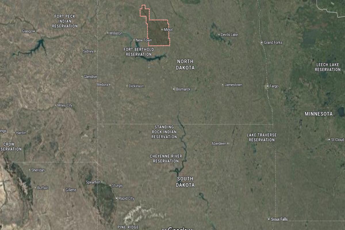
Where is Mountrail County?
Mountrail County is located in northwestern North Dakota, about 130 miles northwest of Bismarck and 35 miles south of the Canadian border. The county seat, Stanley, lies roughly 55 miles east of Williston and 60 miles west of Minot. It is situated in the heart of the Bakken oil field and along U.S. Route 2.
The area is approximately 45 miles north of Lake Sakakawea and 80 miles northeast of Watford City. State Routes 8 and 23 provide additional access through the county. Mountrail County is also about 70 miles west of Rugby in central North Dakota.
#9. Bottineau County, North Dakota
– Overall Rank: 807
– Population: 6,411
– Median household income: $80,113
– Median home value: $188,500 (81% own)
– Median rent: $670 (19% rent)
– Top public schools: Bottineau Junior/Senior High School (grade B minus), Bottineau Elementary School (grade B minus), Westhope High School (grade B minus)
– Top private schools:
– Top places: Westhope (grade B+), Bottineau (grade B+), Whitetail Township (grade B)
About
Bottineau County is known for its scenic beauty, agricultural strength, and close-knit communities rooted in tradition. The landscape features rolling hills, farmland, and forested areas that support farming, recreation, and rural living. Local culture reflects a blend of heritage, outdoor life, and quiet resilience.
Residents value independence, strong community ties, and a connection to nature that shapes daily life. Seasonal festivals, school events, and local gatherings strengthen bonds across generations. Bottineau County offers a peaceful, grounded lifestyle built on tradition, hard work, and regional pride.
Where is Bottineau County?
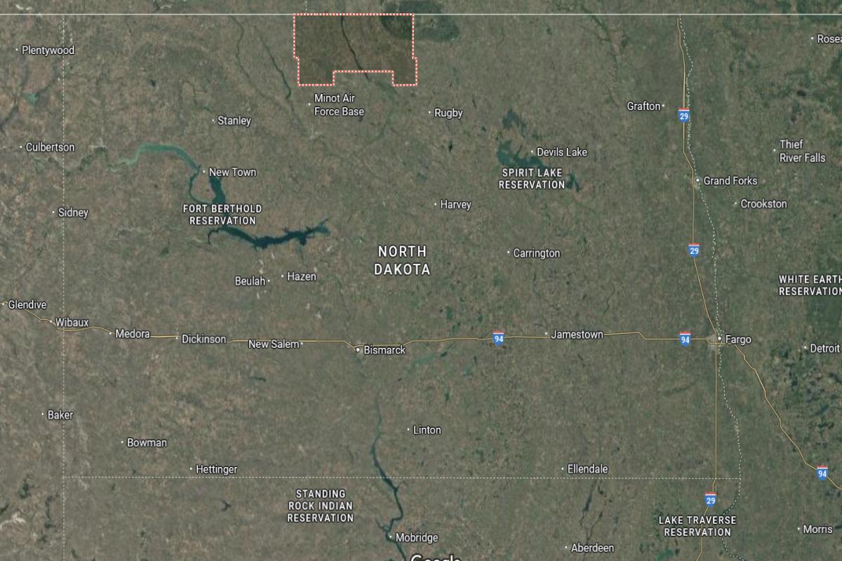
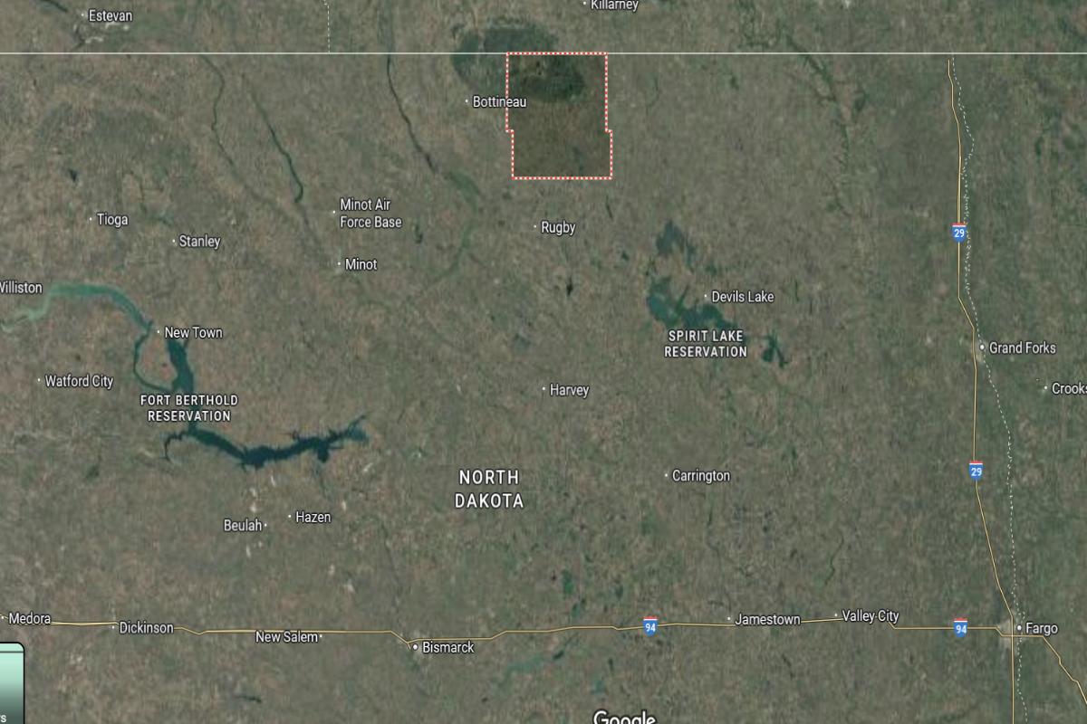
Bottineau County is located in north-central North Dakota, directly along the Canadian border and about 120 miles north of Bismarck. The county seat, Bottineau, is situated roughly 30 miles north of Rugby and 40 miles west of Rolla. It lies in the Turtle Mountains region, known for its forested terrain and proximity to Lake Metigoshe.
The area is approximately 60 miles northeast of Minot and 50 miles west of the International Peace Garden. State Routes 5 and 14 run through the county, providing regional access. Bottineau County is also about 70 miles northwest of Devils Lake.
#8. Barnes County, North Dakota
– Overall Rank: 759
– Population: 10,826
– Median household income: $64,447
– Median home value: $157,800 (74% own)
– Median rent: $773 (26% rent)
– Top public schools: Barnes County North Elementary School (grade A minus), Jefferson Elementary School (grade B+), Valley City Junior High School (grade B+)
– Top private schools: St. Catherine Elementary School (grade unavailable)
– Top places: Valley City (grade B+), Marsh Township (grade A minus), Wimbledon (grade B minus)
About
Barnes County is characterized by its rich farmland, educational presence, and a strong tradition of rural community life. Agriculture drives much of the local economy, with generations of families contributing to a culture of hard work and resilience. The area blends scenic landscapes with active civic and cultural engagement.
Residents value education, heritage, and a cooperative spirit that brings people together. Local events, school programs, and historical preservation reflect pride in both past and future. Barnes County offers a steady, community-centered lifestyle rooted in the land and shared values.
Where is Barnes County?
Barnes County is located in southeastern North Dakota, about 60 miles west of Fargo and 100 miles east of Bismarck. The county seat, Valley City, lies roughly 35 miles east of Jamestown and 45 miles west of Lisbon. It is situated along Interstate 94 in the Sheyenne River Valley.
The area is approximately 80 miles north of Ellendale and 70 miles south of Devils Lake. U.S. Route 52 and State Route 1 run through the county, providing access to nearby towns. Barnes County is also about 55 miles southeast of Carrington.
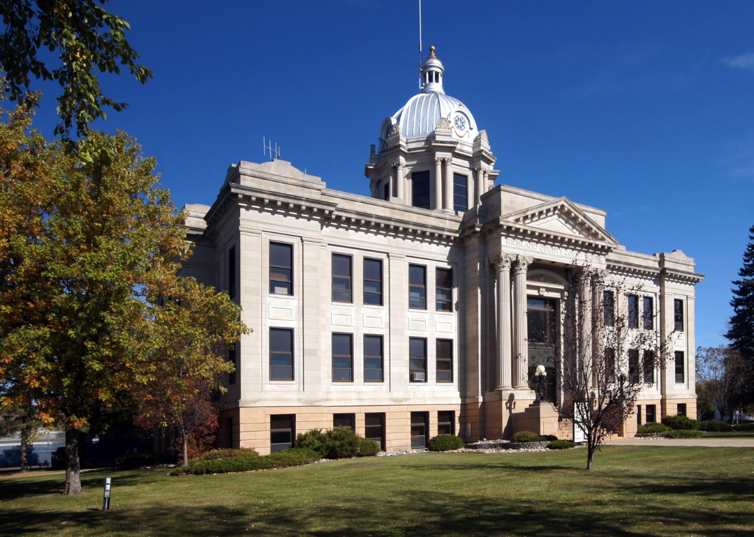
#7. Richland County, North Dakota
– Overall Rank: 750
– Population: 16,548
– Median household income: $67,089
– Median home value: $164,500 (69% own)
– Median rent: $725 (31% rent)
– Top public schools: Wyndmere Elementary School (grade B+), Wahpeton Middle School (grade B+), Hankinson Elementary School (grade B+)
– Top private schools: St. John’s School (grade unavailable)
– Top places: Wahpeton (grade B), Colfax (grade A minus), Walcott (grade B+)
About
Richland County is grounded in its agricultural heritage, with fertile farmland and rural communities that reflect generations of tradition. The economy is centered on crop production and agribusiness, supported by strong local institutions and family-run operations. Scenic countryside and small towns provide a calm, rooted way of life.
Residents value hard work, family, and close community connections built through shared history and mutual support. County fairs, school events, and seasonal celebrations bring people together and strengthen regional pride. Richland County offers a stable, tradition-rich lifestyle shaped by the land and a spirit of cooperation.
Where is Richland County?
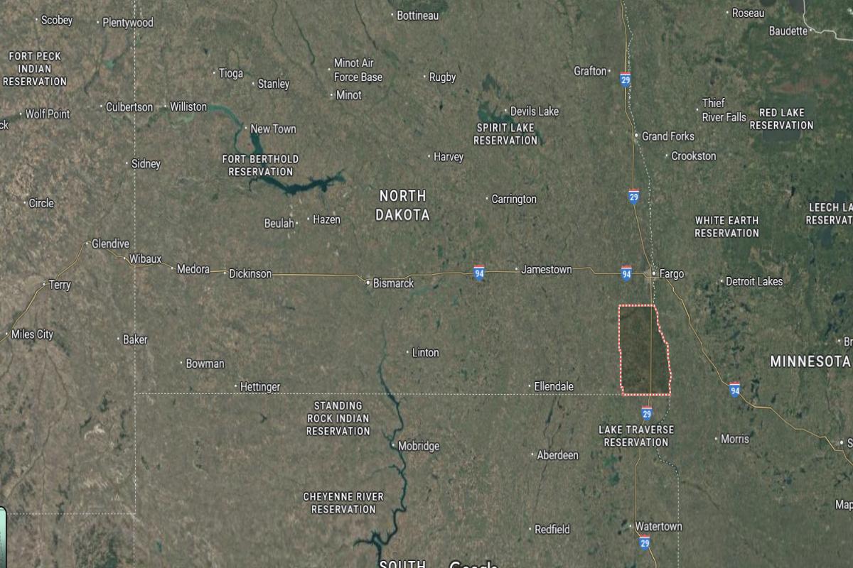
Richland County is located in southeastern North Dakota, directly along the Minnesota border and about 50 miles south of Fargo. The county seat, Wahpeton, lies roughly 30 miles southeast of Valley City and 60 miles northeast of Ellendale. It sits at the confluence of the Bois de Sioux and Otter Tail Rivers, forming the Red River of the North.
The area is approximately 75 miles west of Fergus Falls, Minnesota and 40 miles north of the South Dakota border. U.S. Route 81 and State Route 13 provide access across the county. Richland County is also about 85 miles southeast of Jamestown.
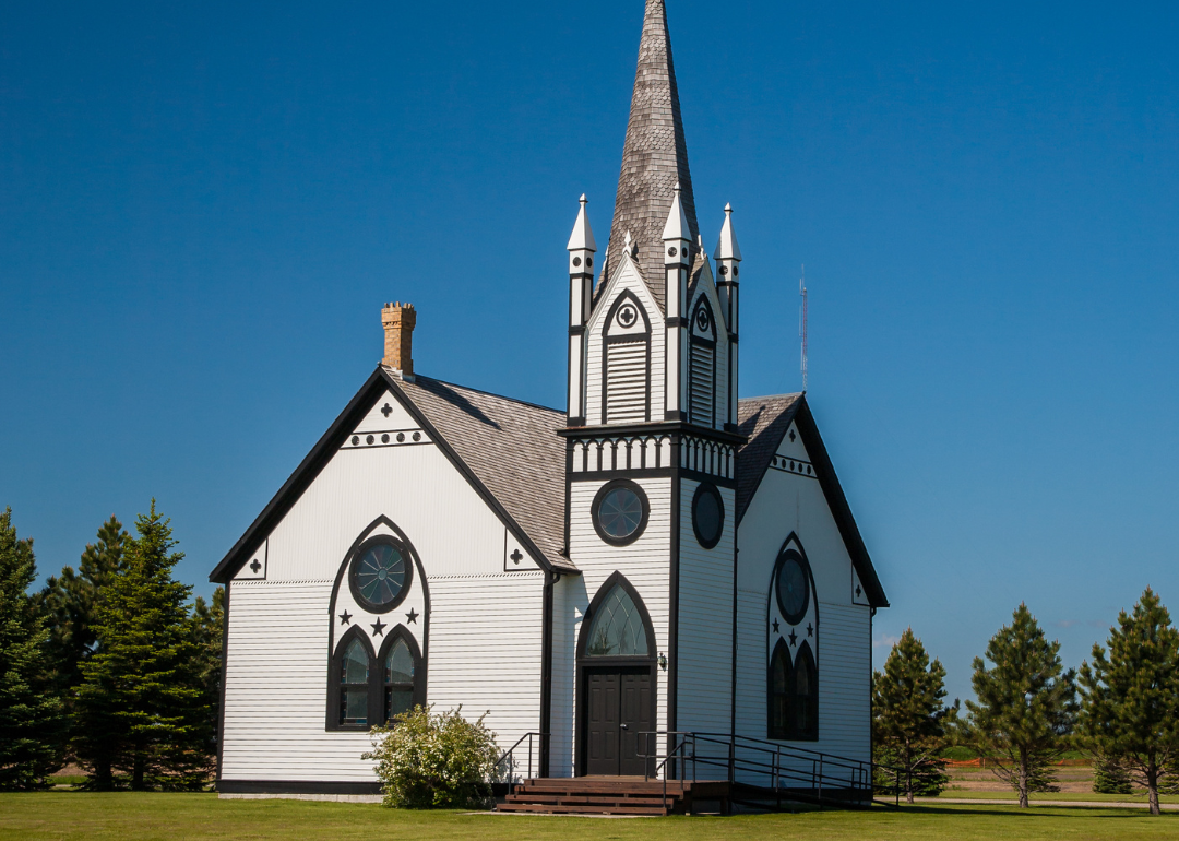
#6. Pembina County, North Dakota
– Overall Rank: 716
– Population: 6,853
– Median household income: $64,243
– Median home value: $112,700 (74% own)
– Median rent: $658 (26% rent)
– Top public schools: Valley-Edinburg Elementary School – Crystal (grade A), North Border Walhalla Elementary School (grade A), North Border Pembina Elementary School (grade A minus)
– Top private schools:
– Top places: Pembina (grade B+), Neche (grade B+), Cavalier (grade B+)
About
Pembina County is rich in agricultural tradition, with vast fields and rural towns that reflect a legacy of farming and community pride. The area’s economy is driven by crop production and ag-based industries, supported by generations of hardworking families. Its landscape and history are closely tied to settlement, trade, and resilience.
Residents value heritage, neighborly support, and a strong connection to the land. Community events, school activities, and historical preservation reflect the county’s enduring spirit. Pembina County offers a peaceful, tradition-centered lifestyle shaped by hard work, shared values, and rural character.
Where is Pembina County?
Pembina County is located in the northeastern corner of North Dakota, directly along the Canadian border and the Minnesota state line. The county seat, Cavalier, is about 80 miles north of Grand Forks and 25 miles west of Pembina, a key border crossing. It lies roughly 15 miles south of the Canadian town of Gretna in Manitoba.
The area is approximately 40 miles northeast of Grafton and 50 miles northwest of Thief River Falls, Minnesota. U.S. Route 81 and State Route 5 provide main transportation routes through the county. Pembina County is also around 60 miles east of Langdon in Cavalier County.
#5. Dickey County, North Dakota
– Overall Rank: 656
– Population: 5,003
– Median household income: $60,250
– Median home value: $164,700 (78% own)
– Median rent: $759 (22% rent)
– Top public schools: Ellendale Elementary School (grade A minus), Oakes Elementary School (grade B), Oakes High School (grade B)
– Top private schools:
– Top places: Oakes (grade B+), Ellendale Township (grade B+), Ellendale (grade B+)
About
Dickey County is rooted in its agricultural landscape, where fertile fields and small towns form the heart of daily life. Farming and ranching drive the local economy, supported by strong family traditions and generational ties to the land. The region reflects a quiet strength and commitment to rural living.
Residents value community, perseverance, and the rhythm of the seasons. Local fairs, school events, and civic gatherings bring people together and celebrate shared heritage. Dickey County offers a grounded, dependable lifestyle built on hard work, connection, and tradition.
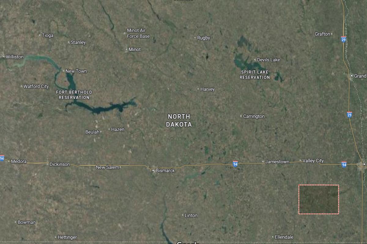
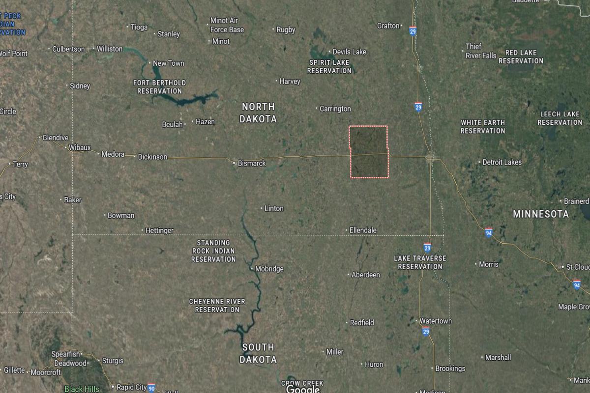
Where is Dickey County?
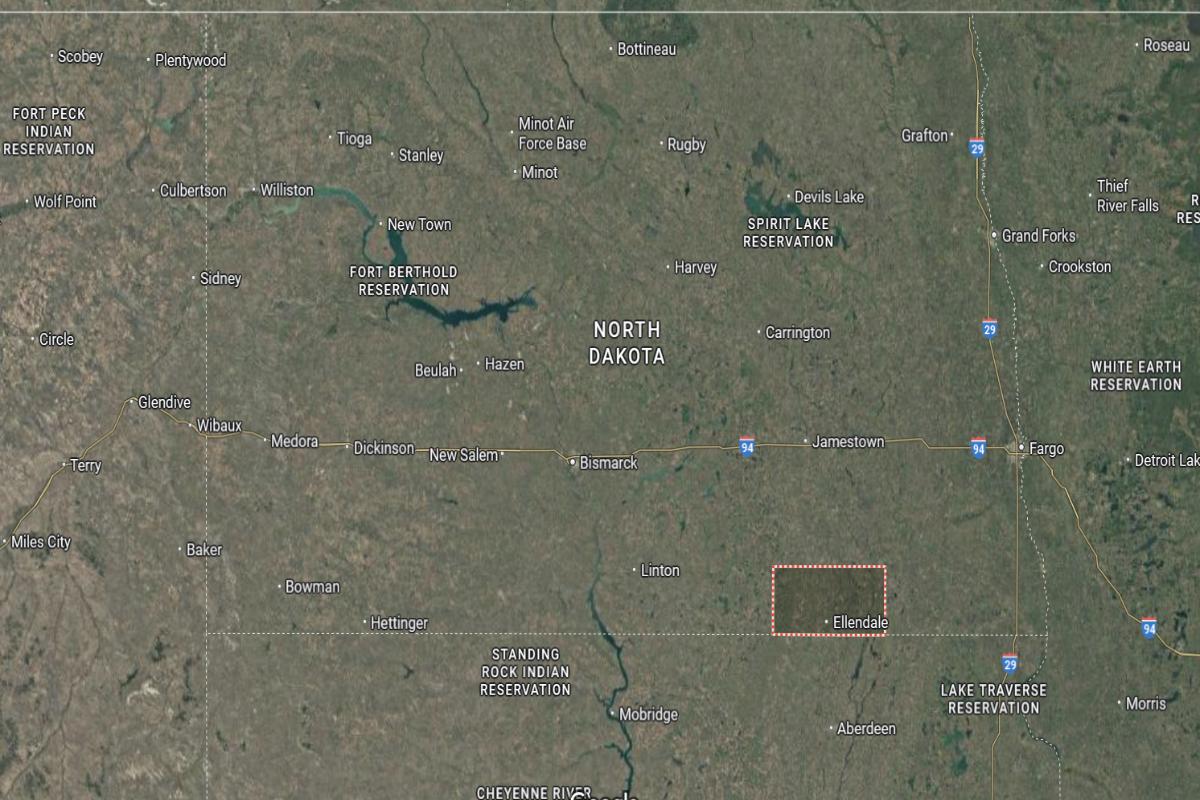
Dickey County is located in southeastern North Dakota, directly along the South Dakota border and about 85 miles southwest of Fargo. The county seat, Ellendale, is situated roughly 45 miles south of Jamestown and 40 miles west of Wahpeton. It lies within a rural landscape of farmland and prairie.
The area is approximately 60 miles northeast of Aberdeen, South Dakota and 70 miles southeast of Carrington. U.S. Route 281 and State Route 11 run through the county, providing access to nearby towns. Dickey County is also about 90 miles east of Bismarck.
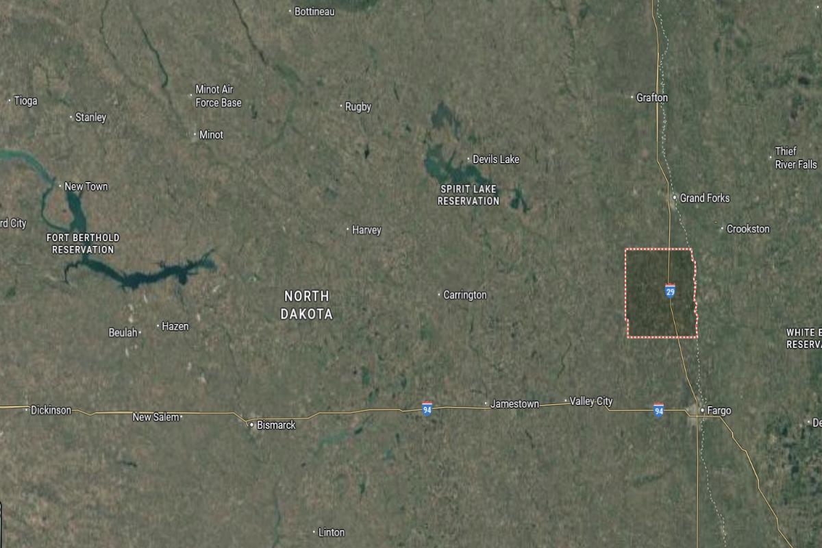
#4. Grand Forks County, North Dakota
– Overall Rank: 426
– Population: 72,927
– Median household income: $64,698
– Median home value: $235,400 (51% own)
– Median rent: $941 (49% rent)
– Top public schools: Manvel Elementary School (grade A), Nathan Twining Elementary School (grade A), Nathan Twining Middle School (grade A minus)
– Top private schools: St. Michael’s School (grade unavailable), Holy Family School (grade unavailable), Forest River School (grade unavailable)
– Top places: Grand Forks (grade A minus), Northwood (grade A minus), Michigan Township (grade A minus)
About
Grand Forks County blends educational influence, urban energy, and agricultural tradition into a diverse and active community. The area features strong institutions, cultural events, and a mix of neighborhoods and farmland that reflect both progress and heritage. Economic life is driven by education, healthcare, agriculture, and technology.
Residents value innovation, civic pride, and a strong sense of connection across generations. Community festivals, university programs, and recreational opportunities bring people together year-round. Grand Forks County offers a balanced lifestyle rooted in growth, tradition, and community engagement.
Where is Grand Forks County?
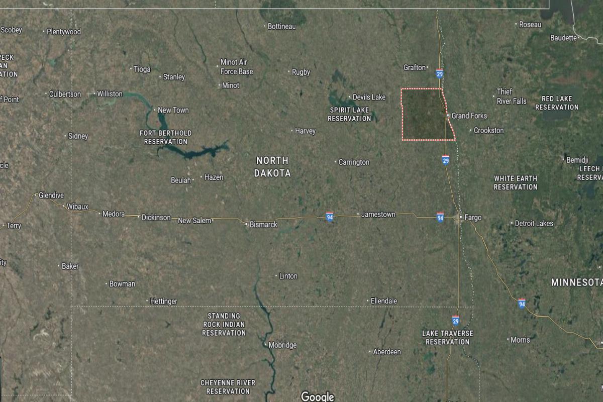
Grand Forks County is located in eastern North Dakota, along the Minnesota border and about 80 miles north of Fargo. The county seat, Grand Forks, lies roughly 75 miles east of Devils Lake and 145 miles northeast of Bismarck. It sits on the Red River of the North and is a major urban and university center.
The area is approximately 30 miles west of Crookston, Minnesota and 40 miles south of the Canadian border. Interstate 29 and U.S. Route 2 intersect in the county, providing key regional connections. Grand Forks County is also about 60 miles northeast of Valley City.
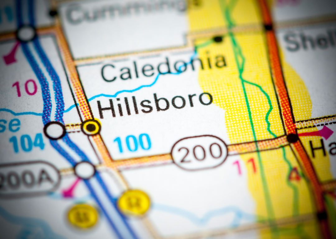
#3. Traill County, North Dakota
– Overall Rank: 375
– Population: 8,004
– Median household income: $81,157
– Median home value: $172,700 (73% own)
– Median rent: $709 (27% rent)
– Top public schools: Peter Boe Jr. Elementary School (grade B+), Hillsboro High School (grade B), Hillsboro Elementary School (grade B)
– Top private schools:
– Top places: Hillsboro (grade A), Mayville (grade B+), Buxton (grade B+)
About
Traill County is known for its rich farmland, historic towns, and a community built on agricultural strength and tradition. The landscape is dotted with family farms and rural communities that reflect a steady, hardworking way of life. Crop production and ag-related industries are central to the local economy.
Residents value close relationships, generational continuity, and pride in their rural heritage. Seasonal events, school activities, and local celebrations bring neighbors together and reinforce a strong community spirit. Traill County offers a peaceful, dependable lifestyle shaped by the land and shared values.
Where is Traill County?
Traill County is located in eastern North Dakota, along the Minnesota border and about 40 miles north of Fargo. The county seat, Hillsboro, lies approximately 35 miles south of Grand Forks and 70 miles east of Valley City. It sits in the Red River Valley, a region known for its flat farmland and proximity to the Red River.
The area is about 60 miles west of Detroit Lakes, Minnesota and 25 miles north of Mayville. Interstate 29 runs through the county, offering direct access between Fargo and Grand Forks. Traill County is also around 50 miles southeast of Devils Lake.
#2. Burleigh County, North Dakota
– Overall Rank: 286
– Population: 98,443
– Median household income: $82,141
– Median home value: $302,300 (71% own)
– Median rent: $975 (29% rent)
– Top public schools: Apple Creek Elementary School (grade A), Century High School (grade A minus), Roosevelt Elementary School (grade A minus)
– Top private schools: Dakota Adventist Academy (grade A minus), St. Mary’s Central High School (grade B+), Shiloh Christian School (grade B minus)
– Top places: Bismarck (grade A minus), Lincoln (grade B), Painted Woods Township (grade A)
About
Burleigh County is marked by its balance of urban energy and rural tradition, with a strong presence in government, business, and community services. The region includes growing neighborhoods, open landscapes, and a mix of industries that support both economic development and quality of life. Farming, public institutions, and small businesses contribute to its steady foundation.
Residents value civic pride, family life, and active participation in local affairs. Community events, parks, and educational programs bring people together across generations. Burleigh County offers a well-rounded lifestyle rooted in progress, tradition, and strong community connections.
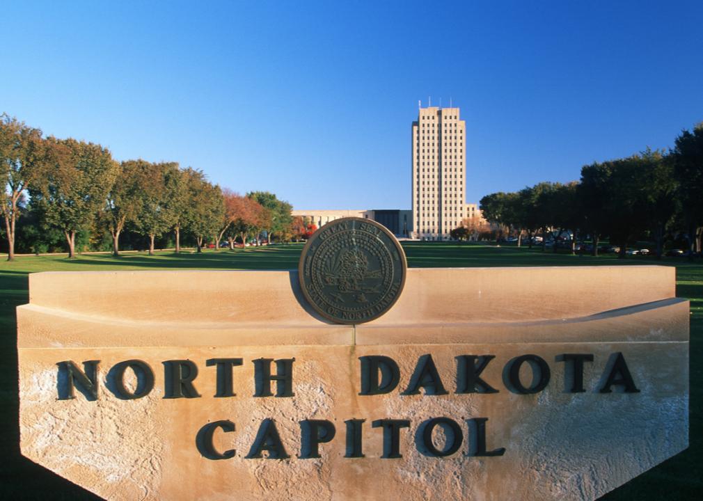
Where is Burleigh County?
Burleigh County is located in south-central North Dakota, about 195 miles west of Fargo and directly across the Missouri River from Mandan in Morton County. The county seat, Bismarck, is the state capital and lies roughly 100 miles south of Minot and 130 miles east of Dickinson. It sits along Interstate 94, serving as a major transportation and administrative hub.
The area is approximately 80 miles west of Jamestown and 90 miles north of the South Dakota border. U.S. Route 83 also runs through the county, connecting it north to Minot and south to Pierre, South Dakota. Burleigh County is around 70 miles southeast of Garrison near Lake Sakakawea.
#1. Cass County, North Dakota
– Overall Rank: 162
– Population: 186,328
– Median household income: $73,249
– Median home value: $270,300 (52% own)
– Median rent: $909 (48% rent)
– Top public schools: Longfellow Elementary School (grade A), Kindred Elementary School (grade A minus), Bennett Elementary School (grade A minus)
– Top private schools: Oak Grove Lutheran School (grade A), Shanley High School & Sullivan Middle School (grade B+), Trinity Elementary School (grade unavailable)
– Top places: Longfellow (grade A), Clara Barton (grade A), Southpointe (grade A)
About
Cass County is a hub of economic activity, education, and cultural diversity, blending urban growth with strong agricultural roots. The area features thriving businesses, vibrant neighborhoods, and expansive farmland that reflect both innovation and tradition. Its economy is driven by technology, healthcare, education, and agribusiness.
Residents value opportunity, community involvement, and a high quality of life supported by modern amenities and regional pride. Festivals, local markets, and civic events foster connection and cultural expression. Cass County offers a dynamic, forward-moving lifestyle grounded in resilience, inclusivity, and heritage.
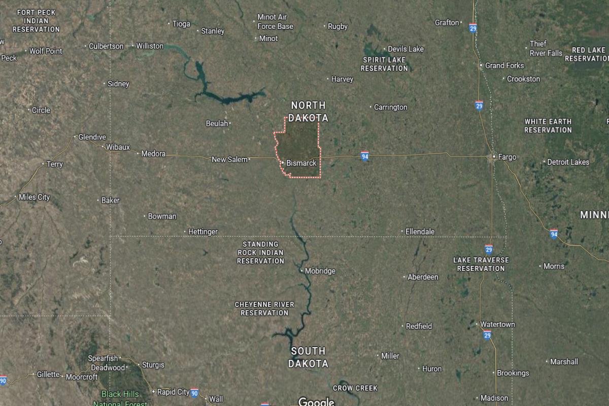
Where is Cass County?
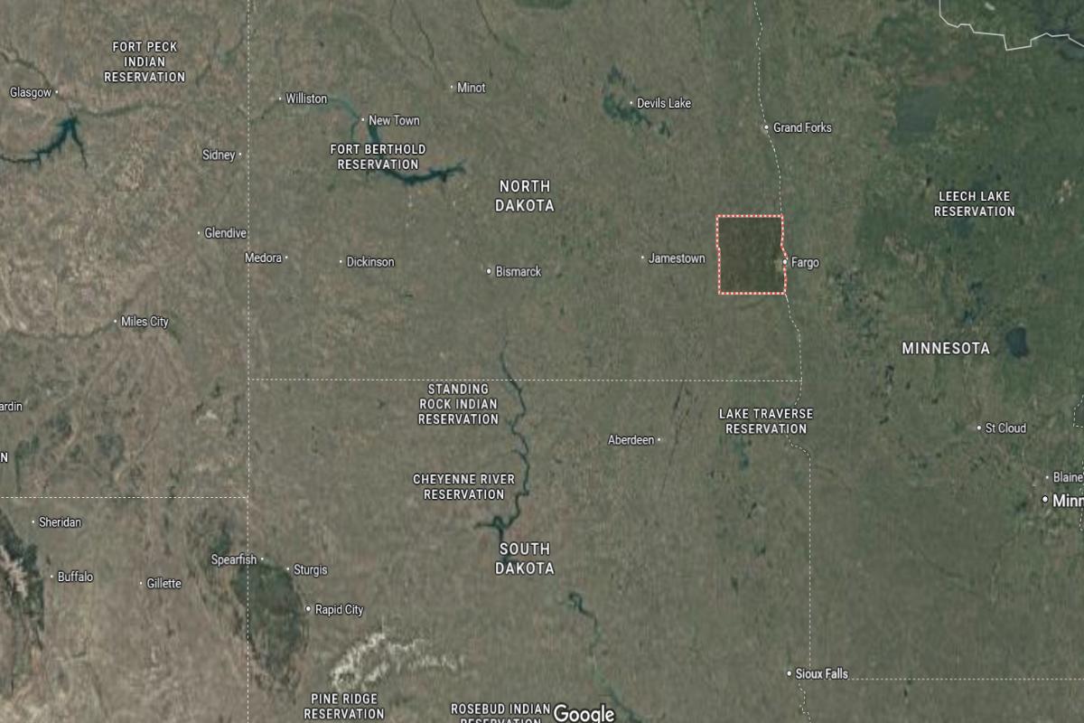
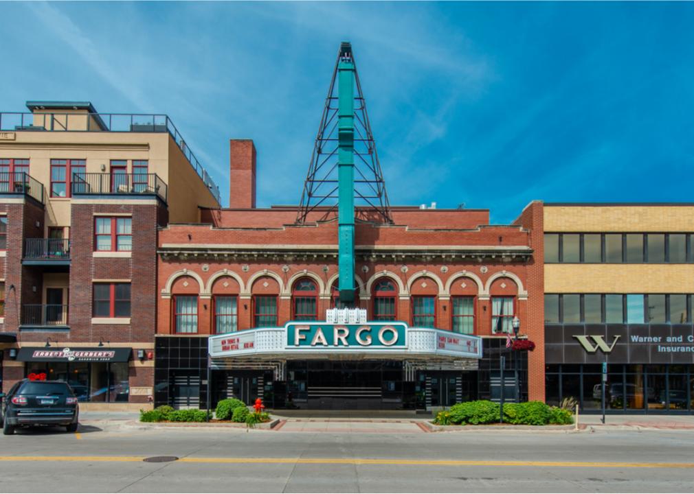
Cass County is located in southeastern North Dakota, directly along the Minnesota border and about 75 miles south of Grand Forks. The county seat, Fargo, is the largest city in the state and lies approximately 135 miles east of Jamestown and 230 miles southeast of Minot. It is positioned on the Red River of the North, serving as a major economic and cultural center.
The area is about 65 miles north of Wahpeton and 55 miles west of Detroit Lakes, Minnesota. Interstate 94 and Interstate 29 intersect in Fargo, providing key transportation routes. Cass County is also around 60 miles southeast of Valley City.
This story features data reporting and writing by Elena Cox and is part of a series utilizing data automation across 50 states.
By Stacker