🔥 Would you like to save this?
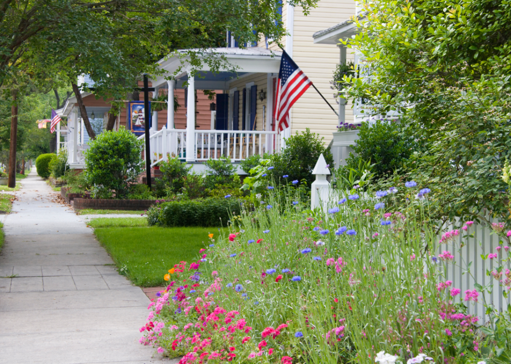
Best counties to live in North Carolina based on a variety of useful data including median home prices for home purchase affordability
More counties in the United States experienced population growth in the last year, according to the latest Census data, even as pandemic-related moving trends begin to normalize.
In order to come up with the very specific design ideas, we create most designs with the assistance of state-of-the-art AI interior design software. Also, assume links that take you off the site are affiliate links such as links to Amazon. this means we may earn a commission if you buy something.
Counties in the South continued to experience growth, particularly in Florida, where 96% of its 67 counties gained new residents. Polk County, Florida, a suburb of Orlando, added the most, with 26,000 people moving there in 2023.
Meanwhile, counties in the Midwest and Northeast continued to lose population, but at slower rates than the year before. Some of the biggest losses were in counties home to large cities, including Cook County, Illinois (home of Chicago) and the boroughs of Brooklyn and Queens in New York.
Many counties are experiencing growth due to their job opportunities, education, or relatively affordable housing costs. Others are favored for their historic or well-designed downtowns or access to cultural opportunities.
Stacker compiled a list of the best counties to live in North Carolina using rankings from Niche. Niche ranks counties by various factors including public schools, educational attainment, cost of living, and housing.
Keep reading to see if your county made the list.
You may also like: These 10 car insurers have the highest market share in North Carolina
#30. Brunswick County, North Carolina
– Overall Rank: 518
– Population: 139,721
– Median household income: $71,193
– Median home value: $284,100 (84% own)
– Median rent: $1,187 (16% rent)
– Top public schools: Brunswick County Early College High School (grade A), Classical Charter Schools of Leland (grade A), Union Elementary School (grade A minus)
– Top private schools: Southport Christian School (grade unavailable), The Academy of Coastal Carolina (grade unavailable), Southeastern Christian Academy (grade unavailable)
– Top places: St. James (grade A), Belville (grade A minus), Oak Island (grade B+)
About
Brunswick County, North Carolina lies along the southeastern coast, where rivers, wetlands, and barrier islands shape both daily life and community identity. Farming and fishing formed its historic base, but in recent decades tourism, real estate, and retirement living have driven much of its growth. Small towns and seaside communities reflect a balance of tradition and modern development.
The county’s economy thrives on its beaches, golf courses, and marinas that draw visitors throughout the year. Agriculture and fishing remain part of the landscape, though service industries, retail, and healthcare now employ many residents. Brunswick County embodies a coastal character where heritage and economic progress move side by side.
Where is Brunswick County?
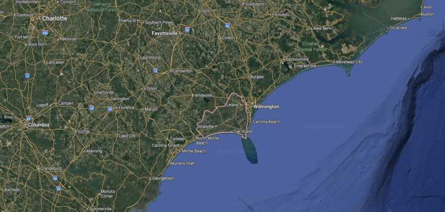
Brunswick County sits in the southeastern corner of North Carolina, bordered by the Atlantic Ocean to the south and the Cape Fear River to the east. It stretches across more than 850 square miles of coastal plain and barrier islands. Bolivia, the county seat, is located inland between Wilmington to the northeast and Myrtle Beach, South Carolina, to the southwest.
U.S. Highway 17 runs through the county, linking its towns and beaches with major coastal cities. Communities such as Shallotte, Leland, and Southport anchor both inland and waterfront areas. With ocean access, river corridors, and highway routes, Brunswick County is positioned as a key coastal gateway at the state’s southern tip.
#29. Madison County, North Carolina
– Overall Rank: 488
– Population: 21,414
– Median household income: $56,664
– Median home value: $236,300 (77% own)
– Median rent: $760 (23% rent)
– Top public schools: Madison Early College High School (grade A minus), Hot Springs Elementary School (grade A minus), Brush Creek Elementary School (grade A minus)
– Top private schools: Woodson Branch Nature School (grade A+), Wolf Creek Academy (grade unavailable), Little Ivy Baptist Academy (grade unavailable)
– Top places: Mars Hill (grade A), South Marshall Township (grade A minus), Mars Hill Township (grade A minus)

About
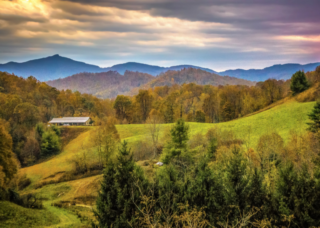
Madison County, North Carolina rises in the Blue Ridge Mountains, where steep ridges and winding rivers have shaped settlement for generations. Farming and timber once anchored its economy, later joined by tourism and small-scale industry. Marshall, the county seat, reflects both mountain heritage and the steady presence of civic and cultural life.
Economic life today blends agriculture, outdoor recreation, and growth tied to nearby Asheville. Local festivals, music traditions, and craft markets highlight the county’s Appalachian roots while supporting small businesses. Madison County carries forward a mountain identity where heritage, economy, and community remain closely connected.
Where is Madison County?
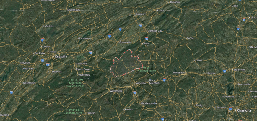
Madison County is tucked into the mountains of western North Carolina, bordered by Tennessee to the north and Buncombe County to the south. It spans about 450 square miles of rugged Appalachian terrain and river valleys. Marshall, the county seat, lies along the French Broad River about 20 miles north of Asheville.
The county is crossed by U.S. Highway 25/70, providing access east toward Asheville and north into Tennessee. Other towns include Mars Hill near Interstate 26 and Hot Springs on the state line. Madison County’s location places it in a mountain corridor that links North Carolina with eastern Tennessee.
#28. Pender County, North Carolina
– Overall Rank: 472
– Population: 61,592
– Median household income: $74,538
– Median home value: $240,800 (82% own)
– Median rent: $1,039 (18% rent)
– Top public schools: Pender Early College High School (grade A), Surf City Elementary (grade A minus), Topsail Middle School (grade A minus)
– Top private schools: Penderlea Christian Academy (grade unavailable)
– Top places: Hampstead (grade A minus), Surf City (grade A minus), Burgaw (grade B)
About
Pender County, North Carolina stretches from sandy beaches to inland forests, giving it both a coastal and rural character. Its economy has historically rested on farming, timber, and fishing, but tourism and residential growth now play a major role. Burgaw, the county seat, serves as a small-town hub surrounded by communities tied to both land and water.
Today the economy reflects a mix of agriculture, seafood, and expanding service industries. Visitors and residents alike enjoy beaches, rivers, and historic sites that fuel tourism and local pride. Pender County represents a place where natural resources and modern growth continue to shape community life.
Where is Pender County?
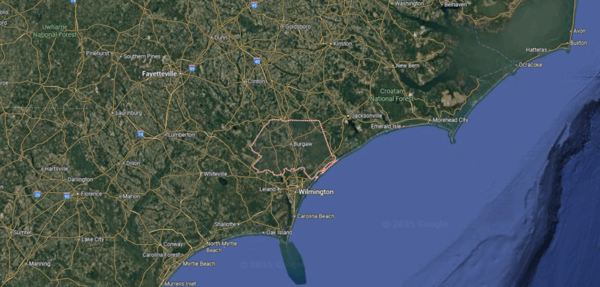
Pender County lies along the southeastern coast of North Carolina, bordered by Onslow County to the northeast and New Hanover County to the south. It covers about 930 square miles, stretching from Atlantic shoreline to inland forests and farmland. Burgaw, the county seat, is located inland about 25 miles north of Wilmington.
U.S. Highway 17 serves as the main north–south route, connecting coastal communities with Wilmington and Jacksonville. Topsail Beach and Surf City line the eastern edge, offering access to barrier islands. With both coastal highways and inland corridors, Pender County links beach towns, rural areas, and nearby urban centers.
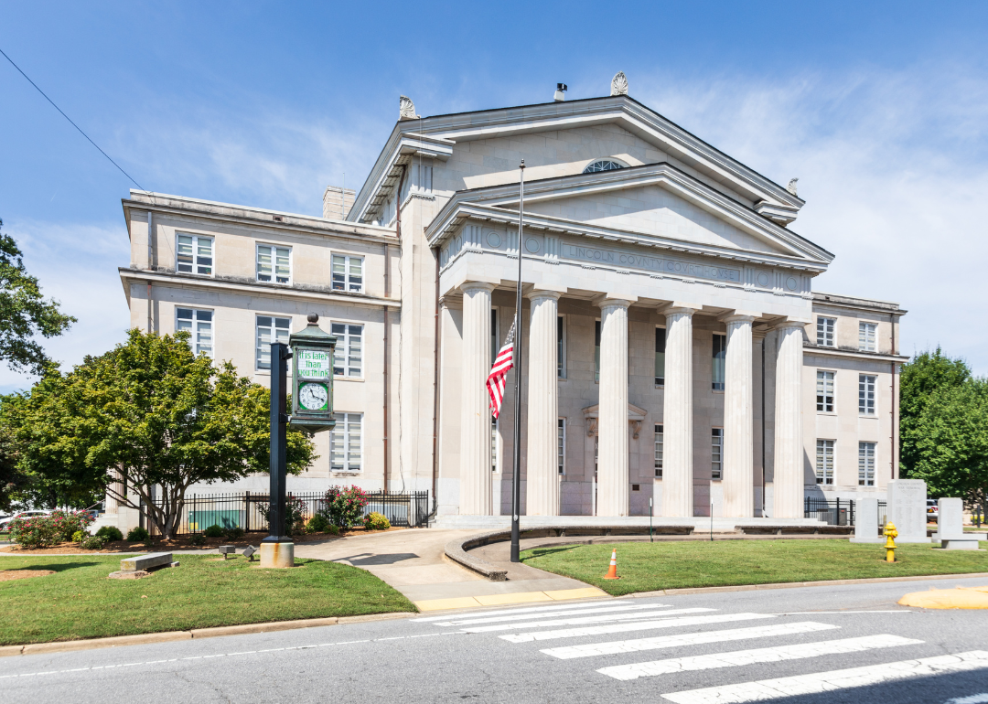
#27. Davie County, North Carolina
– Overall Rank: 448
– Population: 43,030
– Median household income: $69,105
– Median home value: $219,400 (82% own)
– Median rent: $838 (18% rent)
– Top public schools: Davie County Early College High School (grade A), Shady Grove Elementary School (grade A minus), North Davie Middle School (grade A minus)
– Top private schools: Trinity Baptist Academy (grade unavailable)
– Top places: Advance (grade A minus), Mocksville (grade B+), Bermuda Run (grade B+)
About
Davie County, North Carolina is defined by its rolling Piedmont hills, historic small towns, and long ties to farming communities. Mocksville, the county seat, stands as a center of civic and cultural life, reflecting both heritage and steady growth. Generational traditions remain visible in its rural landscape and community gatherings.
Alongside agriculture, the economy has expanded to include manufacturing, healthcare, and service industries. Festivals, school events, and local markets strengthen social ties while supporting small businesses. Davie County reflects a blend of rural heritage and modern opportunity, carried forward by both land and community.
Where is Davie County?
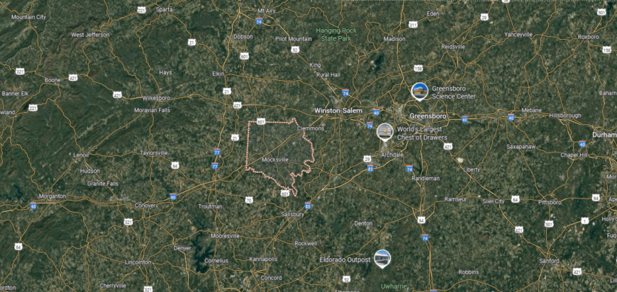
Davie County is positioned in the Piedmont region of North Carolina, bordered by Yadkin County to the north and Rowan County to the south. It spans about 267 square miles of rolling farmland and small towns. Mocksville, the county seat, sits near the center along Interstate 40, about 25 miles west of Winston-Salem.
Interstate 40 serves as the county’s primary east–west corridor, linking it with the Triad region and western North Carolina. U.S. Highway 601 runs north–south through Mocksville, adding another direct route. Davie County’s location provides easy access to larger cities while maintaining a rural, small-town setting.
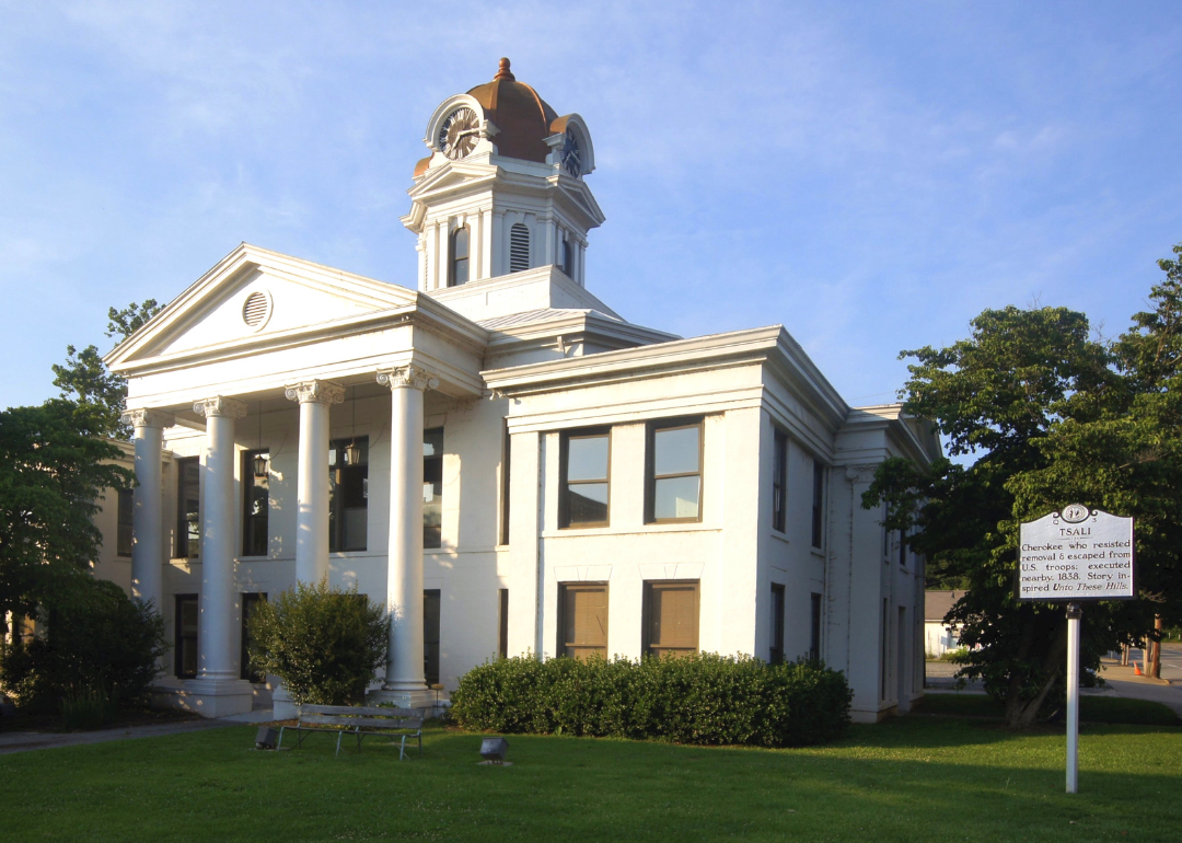
#26. Lincoln County, North Carolina
– Overall Rank: 423
– Population: 87,933
– Median household income: $75,672
– Median home value: $241,200 (79% own)
– Median rent: $928 (21% rent)
– Top public schools: Catawba Springs Elementary School (grade A), St. James Elementary School (grade A), Rock Springs Elementary School (grade A)
– Top private schools: Combine Academy (grade unavailable), Long Shoals Wesleyan Academy (grade unavailable), Pursuit Preparatory Academy (grade unavailable)
– Top places: Westport (grade A minus), Denver (grade A minus), Lowesville (grade B)
You may also like: Counties where the most opioids are dispensed in North Carolina
About
Lincoln County, North Carolina rests along the Catawba River, where rolling hills and waterways have supported communities since the 18th century. Its early history is tied to ironworks and farming, industries that laid the foundation for growth in the region. Lincolnton, the county seat, preserves historic character while serving as a hub for business and civic life.
Today, the economy combines manufacturing, retail, and service sectors with the county’s enduring agricultural base. Lake Norman and surrounding landscapes provide recreation that strengthens both tourism and quality of life. Lincoln County reflects a balance of deep-rooted history and modern development, where tradition and progress continue side by side.
Where is Lincoln County?
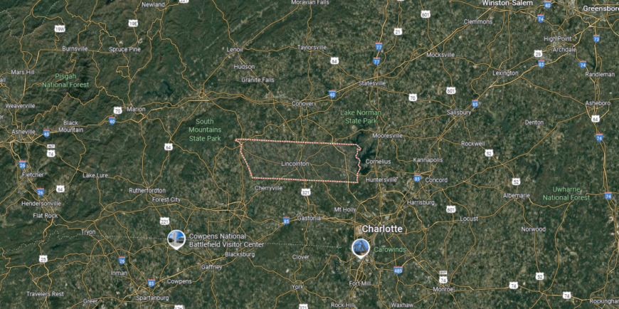
Lincoln County is located in the western Piedmont of North Carolina, bordered by Catawba County to the north, Gaston County to the south, and Cleveland County to the west. It covers about 307 square miles of rolling hills and river valleys. Lincolnton, the county seat, sits near the center of the county along U.S. Highway 321.
The county lies just 30 miles northwest of Charlotte, giving it close access to a major metropolitan area. Lake Norman forms part of its eastern boundary, bringing both recreation and residential growth. With highways connecting to Charlotte, Hickory, and Shelby, Lincoln County is positioned at a key crossroads in the Piedmont region.
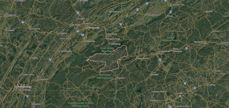
#25. Swain County, North Carolina
– Overall Rank: 412
– Population: 14,130
– Median household income: $52,818
– Median home value: $178,900 (73% own)
– Median rent: $690 (27% rent)
– Top public schools: Mountain Discovery Charter School (grade B+), Swain County West Elementary School (grade B), Swain County High School (grade B)
– Top private schools: New Kituwah Academy (grade unavailable), Grace Christian Academy (grade unavailable)
– Top places: Charleston Township (grade A minus), Cherokee (grade B+), Bryson City (grade B+)
About
Swain County, North Carolina lies deep in the Smoky Mountains, where steep ridges, river valleys, and forested slopes shape its character. Much of its land is preserved in Great Smoky Mountains National Park, making natural beauty central to both daily life and identity. Bryson City, the county seat, offers a small-town hub surrounded by some of the state’s most scenic landscapes.
Tourism drives much of the local economy, with hiking, rafting, and park access drawing visitors year-round. Small businesses, outdoor outfitters, and hospitality services thrive alongside traditional ties to farming and crafts. Swain County reflects a mountain way of life where natural resources, community, and economy are deeply intertwined.
Where is Swain County?
🔥 Would you like to save this?
Swain County is in western North Carolina, bordered by Graham County to the west, Jackson County to the southeast, and the Tennessee state line to the north. It spans roughly 541 square miles, much of it covered by the Great Smoky Mountains National Park and Nantahala National Forest. Bryson City, the county seat, is located near the Tuckasegee River and serves as the county’s main community.
U.S. Highway 74 runs east–west through Bryson City, connecting the county to Asheville and Chattanooga. Other routes, including U.S. 19, provide access to mountain towns and park entrances. Swain County’s location at the heart of the Smokies makes it a natural gateway between North Carolina and Tennessee.
#24. Craven County, North Carolina
– Overall Rank: 397
– Population: 101,098
– Median household income: $61,676
– Median home value: $194,100 (68% own)
– Median rent: $1,056 (32% rent)
– Top public schools: Craven Early College High School (grade A), Early College East High School (grade A minus), W. Jesse Gurganus Elementary School (grade A minus)
– Top private schools: The Epiphany School of Global Studies (grade A minus), New Bern Christian Academy (grade C minus), Saint Paul Catholic School (grade unavailable)
– Top places: Trent Woods (grade A), River Bend (grade A minus), James City (grade A minus)
About
Craven County, North Carolina rests at the meeting of the Neuse and Trent Rivers, where waterways have shaped settlement, trade, and culture for centuries. Founded in the early 1700s, the county carries a deep colonial history, with New Bern—the former state capital and current county seat—serving as a centerpiece of heritage and civic life. Its landscape blends riverfront towns, farmland, and coastal woodlands.
The economy is supported by a mix of manufacturing, military presence, and tourism tied to its historic sites and waterfront access. Festivals, arts, and community events highlight the county’s cultural depth while strengthening local pride. Craven County represents a place where history, economy, and community remain closely connected to the rivers that define it.
Where is Craven County?
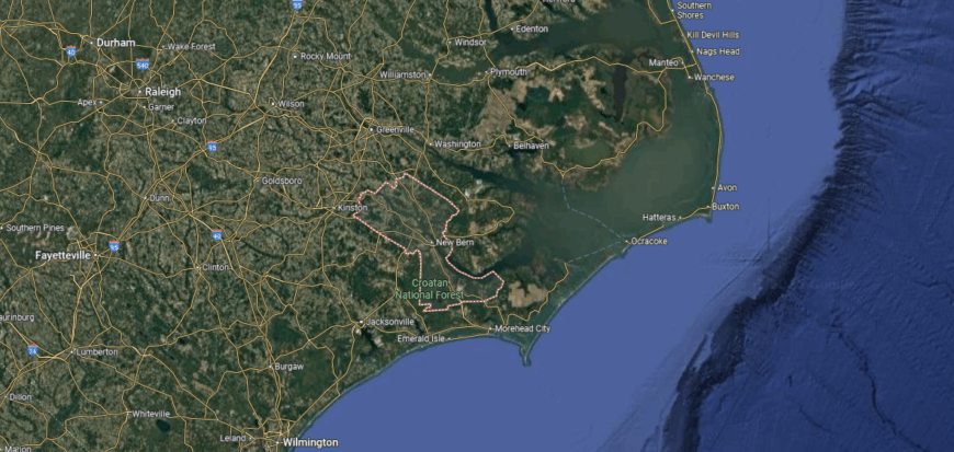
Craven County lies in the eastern part of North Carolina, bordered by Pamlico County to the east, Jones County to the south, and Pitt County to the north. It spans more than 770 square miles across river lowlands and coastal plain. New Bern, the county seat, is positioned at the junction of the Neuse and Trent rivers, about 35 miles from the Atlantic coast.
The county is crossed by U.S. Highways 17, 70, and 55, creating direct routes to Raleigh, Wilmington, and Morehead City. Havelock, one of its largest towns, hosts Marine Corps Air Station Cherry Point, while Vanceboro anchors the northwest corner. Craven County’s setting provides a blend of inland and coastal access, making it a key connector in eastern North Carolina.
#23. Jackson County, North Carolina
– Overall Rank: 393
– Population: 42,388
– Median household income: $51,482
– Median home value: $240,500 (62% own)
– Median rent: $804 (38% rent)
– Top public schools: Catamount School (grade A), Jackson County Early College (grade A minus), Fairview Elementary School (grade B+)
– Top private schools: Victory Christian School (grade unavailable), Heritage Christian Academy (grade unavailable)
– Top places: Sylva (grade A minus), Forest Hills (grade A+), Dillsboro (grade A)
About
Jackson County, North Carolina stretches across the Blue Ridge Mountains, where high ridges, valleys, and rivers shape both landscape and lifestyle. Its history is tied to farming and small mountain communities, later transformed by the arrival of railroads and tourism. Sylva, the county seat, offers a blend of historic downtown life and modern growth.
Western Carolina University adds an educational and cultural dimension, supporting both the local economy and community life. Tourism also plays a key role, with the Great Smoky Mountains and Blue Ridge Parkway drawing visitors year-round. Jackson County reflects a mountain identity where heritage, learning, and natural beauty come together in daily rhythms.
Where is Jackson County?
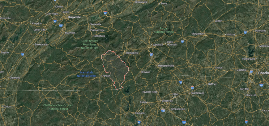
Jackson County is in western North Carolina, bordered by Swain County to the north, Macon County to the west, and Transylvania County to the east. It spans about 495 square miles of mountain ridges, valleys, and river basins in the southern Appalachians. Sylva, the county seat, is located near the center along U.S. Highway 23.
The county is traversed by U.S. Highways 23, 74, and 441, giving it direct links to Asheville, Franklin, and Cherokee. Other communities include Cullowhee, home to Western Carolina University, and Cashiers in the southern mountains. Jackson County’s position in the Blue Ridge places it between higher mountain passes and major regional routes.
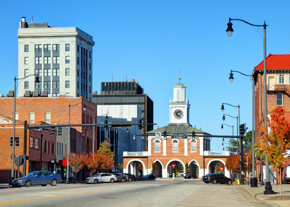
#22. Cumberland County, North Carolina
– Overall Rank: 374
– Population: 335,207
– Median household income: $55,551
– Median home value: $166,600 (53% own)
– Median rent: $1,098 (47% rent)
– Top public schools: Cross Creek Early College High School (grade A), Massey Hill Classical High School (grade A), Cumberland International Early Colleges (grade A)
– Top private schools: Fayetteville Academy (grade A+), Fayetteville Christian School (grade A), Riverside Christian Academy (grade A)
– Top places: Spring Lake (grade B+), Hope Mills (grade B+), Fayetteville (grade B+)
About
Cumberland County, North Carolina is anchored by Fayetteville, a city with deep Revolutionary War roots and a long tradition of civic life. The Cape Fear River winds through its landscape, shaping settlement patterns and providing a historic link to trade and transportation. Communities across the county reflect both a strong military presence and the heritage of Southern culture.
The economy is heavily influenced by Fort Liberty (formerly Fort Bragg), one of the nation’s largest military installations, which supports jobs and shapes local identity. Healthcare, education, and retail also provide stability, while cultural events and museums highlight the area’s history. Cumberland County stands as a place where tradition, service, and growth come together to define community life.
Where is Cumberland County?
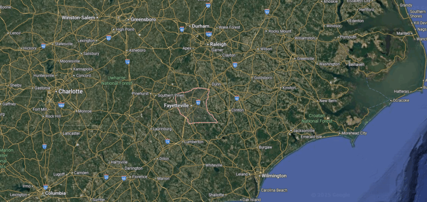
Cumberland County is located in south-central North Carolina, bordered by Harnett County to the north, Sampson County to the east, and Robeson County to the south. It covers about 653 square miles across the Sandhills region. Fayetteville, the county seat and largest city, sits along the Cape Fear River and serves as a major urban hub.
Interstate 95 passes through the eastern side of the county, linking it to the East Coast corridor, while Interstate 295 provides a bypass around Fayetteville. U.S. Highways 401, 301, and 87 connect smaller towns such as Hope Mills, Spring Lake, and Stedman. Cumberland County’s location gives it strong highway access and places it at the center of both military and regional travel routes.
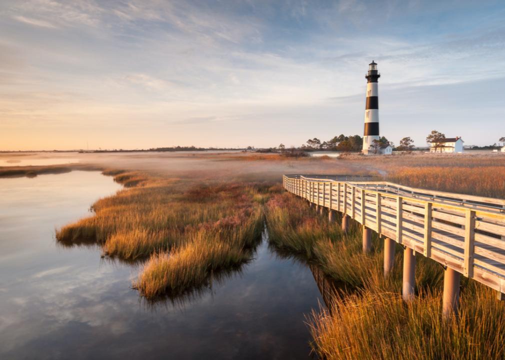
#21. Dare County, North Carolina
– Overall Rank: 348
– Population: 37,160
– Median household income: $79,742
– Median home value: $386,600 (78% own)
– Median rent: $1,259 (22% rent)
– Top public schools: Kitty Hawk Elementary School (grade B+), First Flight Middle School (grade B+), Manteo Middle School (grade B+)
– Top private schools: Wanchese Christian Academy (grade B minus), Heron Pond Montessori School (grade unavailable)
– Top places: Nags Head (grade A), Manteo (grade A minus), Kill Devil Hills (grade A minus)
You may also like: Best-performing North Carolina stocks last week
About
Dare County, North Carolina stretches across the Outer Banks, where barrier islands, dunes, and the Atlantic Ocean define both its setting and its way of life. It is historically tied to fishing, maritime trade, and the legacy of the Wright Brothers’ first flight at Kill Devil Hills. Manteo, the county seat, anchors civic and cultural life while maintaining the feel of a coastal village.
Tourism dominates the economy, with beaches, lighthouses, and wildlife refuges drawing visitors year-round. Fishing and small businesses remain important, blending tradition with modern service industries. Dare County reflects a coastal identity where history, economy, and natural beauty remain inseparable.
Where is Dare County?
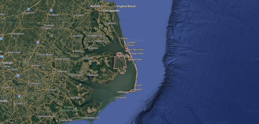
Dare County stretches across the Outer Banks of North Carolina, bordered by Currituck County to the north and Hyde County to the west. It covers about 1,562 square miles, though much of that area is water surrounding barrier islands and sounds. Manteo, the county seat, is located on Roanoke Island between the mainland and the Atlantic coast.
The county is accessed by U.S. Highway 64 from the west, which crosses Roanoke Island before continuing onto the Outer Banks. North–south travel along the barrier islands follows N.C. Highway 12, linking communities like Nags Head, Kill Devil Hills, and Hatteras. Dare County’s setting places it at the heart of North Carolina’s coastal corridor, where ocean and sound shape its accessibility.
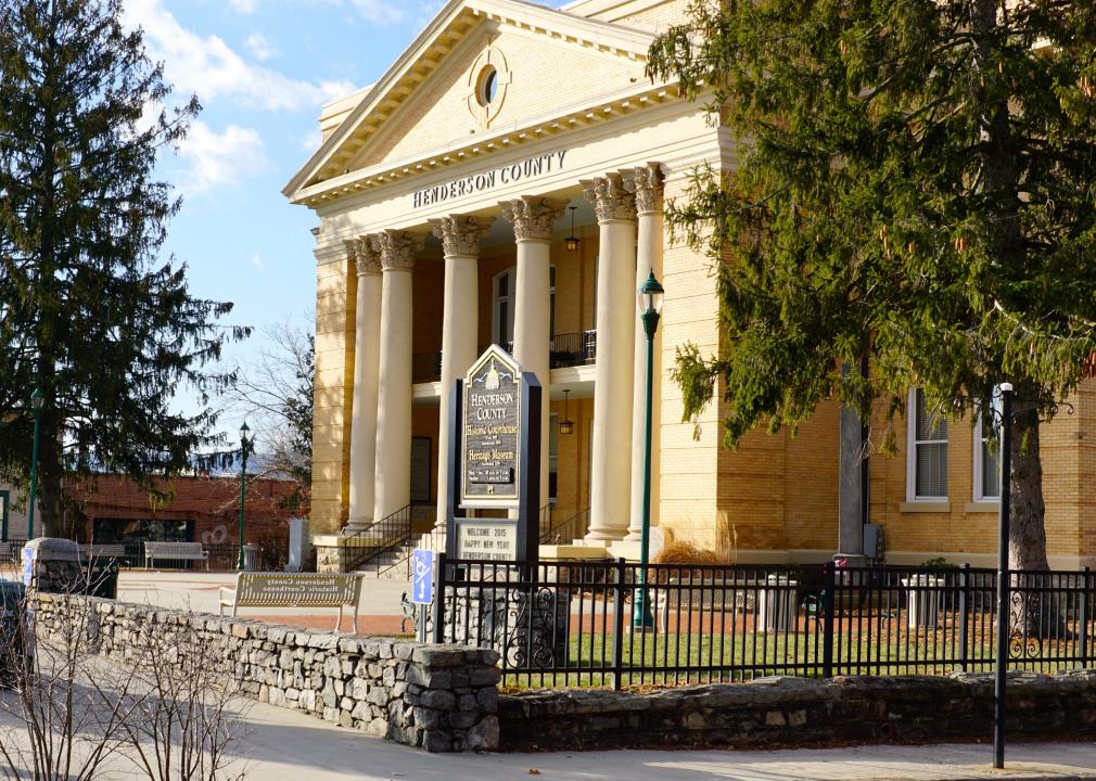
#20. Henderson County, North Carolina
– Overall Rank: 325
– Population: 116,469
– Median household income: $65,508
– Median home value: $291,500 (74% own)
– Median rent: $1,032 (26% rent)
– Top public schools: Henderson County Early College High School (grade A), Glenn C. Marlow Elementary School (grade A), Hendersonville Elementary School (grade A minus)
– Top private schools: Veritas Christian Academy (grade A), Fletcher Academy (grade A minus), Captain Gilmer Christian School (grade A+)
– Top places: Balfour (grade A), Flat Rock (grade A), Laurel Park (grade A)
About
Henderson County, North Carolina lies in the Blue Ridge foothills, where orchards, valleys, and small towns shape both its landscape and traditions. Its history is tied to farming and mountain settlement, with Hendersonville, the county seat, serving as a cultural and civic center. The area’s setting provides both a connection to heritage and opportunities for recreation.
The economy is anchored by apple production, giving the county recognition as one of the state’s leading fruit producers. Tourism, healthcare, and manufacturing also contribute, diversifying opportunities for residents. Henderson County reflects a mountain character where agriculture, community, and growth come together in a balanced way.
Where is Henderson County?

Henderson County is in western North Carolina, bordered by Buncombe County to the north, Transylvania County to the west, and Polk County to the east. It spans about 375 square miles within the Blue Ridge Mountains and adjoining valleys. Hendersonville, the county seat, sits near the center along U.S. Highway 64, about 25 miles south of Asheville.
Interstate 26 runs diagonally through the county, connecting it with Asheville to the north and Spartanburg, South Carolina, to the south. Other routes such as U.S. Highway 25 and U.S. Highway 176 link smaller towns including Flat Rock, Fletcher, and Mills River. Henderson County’s location provides direct access to both mountain passes and major regional highways.
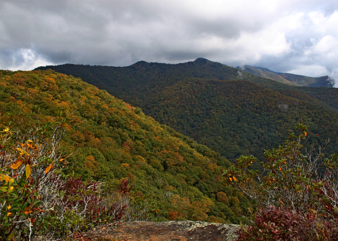
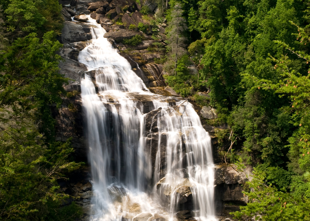
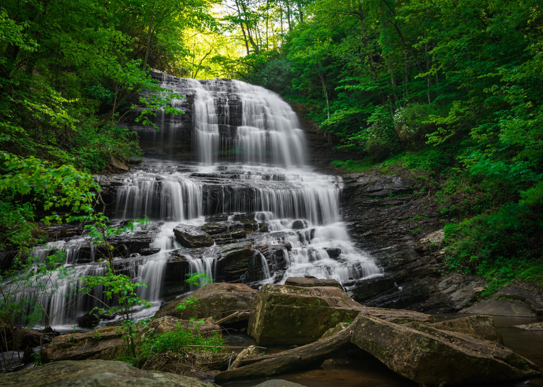
#19. Transylvania County, North Carolina
– Overall Rank: 297
– Population: 33,131
– Median household income: $62,056
– Median home value: $298,600 (76% own)
– Median rent: $861 (24% rent)
– Top public schools: Brevard Academy (grade A), Brevard Middle School (grade A minus), Brevard High School (grade B+)
– Top private schools: Mountain Sun Community School (grade unavailable), Bethany Christian School (grade unavailable), The Outdoor Academy (grade unavailable)
– Top places: Brevard (grade B+), Little River Township (grade A minus), Eastatoe Township (grade A minus)
About
Transylvania County, North Carolina is known as the “Land of Waterfalls,” with more than 250 cascades scattered through its forests and mountains. Its landscape is shaped by Pisgah National Forest, DuPont State Recreational Forest, and Gorges State Park, making nature central to community life. Brevard, the county seat, blends small-town charm with cultural traditions tied to music and the arts.
Tourism drives much of the economy, supported by outdoor recreation, craft industries, and local businesses. Education and small manufacturing also contribute, helping balance growth with heritage. Transylvania County reflects a mountain identity where natural beauty, economy, and culture remain deeply connected.
Where is Transylvania County?
🔥 Would you like to save this?
Transylvania County lies in the far western part of North Carolina, bordered by Henderson County to the east, Jackson County to the west, and the South Carolina state line to the south. It covers about 381 square miles, much of it within the Blue Ridge Mountains and Pisgah National Forest. Brevard, the county seat, is located near the center along U.S. Highway 64.
The county is crossed by U.S. Highways 64, 276, and 178, giving it access to Asheville, Highlands, and Greenville, South Carolina. Smaller communities include Rosman in the southwest and Lake Toxaway in the mountains to the west. Transylvania County’s setting at the edge of the Blue Ridge makes it a natural gateway between western North Carolina and upstate South Carolina.
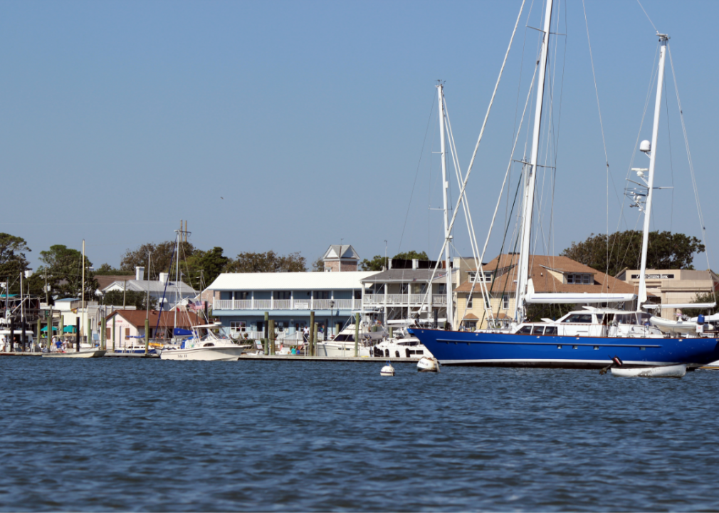
#18. Carteret County, North Carolina
– Overall Rank: 287
– Population: 68,353
– Median household income: $66,965
– Median home value: $277,400 (73% own)
– Median rent: $1,009 (27% rent)
– Top public schools: Tiller School (grade A), Atlantic Elementary School (grade A), Bogue Sound Elementary School (grade A)
– Top private schools: Gramercy Christian School (grade C), St. Egbert Catholic School (grade unavailable), Grace Christian School (grade unavailable)
– Top places: Pine Knoll Shores (grade A minus), Emerald Isle (grade A minus), Cedar Point (grade A minus)
About
Carteret County, North Carolina rests along the Crystal Coast, where fishing villages, barrier islands, and sandy inlets define its character. Beaufort, the county seat, reflects centuries of maritime history in its streets, harbors, and community traditions. The connection to the sea remains strong, shaping both daily life and cultural identity.
Carteret County’s economy blends commercial fishing, seafood industries, and tourism centered on its beaches, lighthouses, and natural preserves. Marine research facilities and small businesses add depth, providing opportunities beyond its traditional trades. The county represents a place where ocean, heritage, and livelihood are inseparable, each reinforcing the other.
Where is Carteret County?
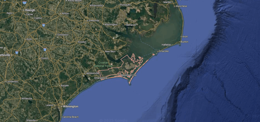
Carteret County is positioned along North Carolina’s southern coast, bordered by Onslow County to the west, Craven County to the north, and the Atlantic Ocean to the south. It spans about 1,341 square miles, much of it water, with barrier islands and sounds shaping its geography. Beaufort, the county seat, is located near the central shoreline along U.S. Highway 70.
The county’s primary routes include U.S. Highway 70, which links inland cities to the Crystal Coast, and N.C. Highway 24 running east–west across coastal communities. Morehead City, Atlantic Beach, and Emerald Isle anchor its waterfront towns. Carteret County’s location places it directly on the coast, providing access to both inland corridors and the open Atlantic.
#17. Polk County, North Carolina
– Overall Rank: 274
– Population: 19,538
– Median household income: $60,465
– Median home value: $255,000 (77% own)
– Median rent: $984 (23% rent)
– Top public schools: Tryon Elementary School (grade A), Saluda Elementary School (grade A), Polk Central School (grade A)
– Top private schools: Tryon Seventh-day Adventist School (grade unavailable)
– Top places: Tryon (grade A), Saluda Township (grade A), Columbus (grade A minus)
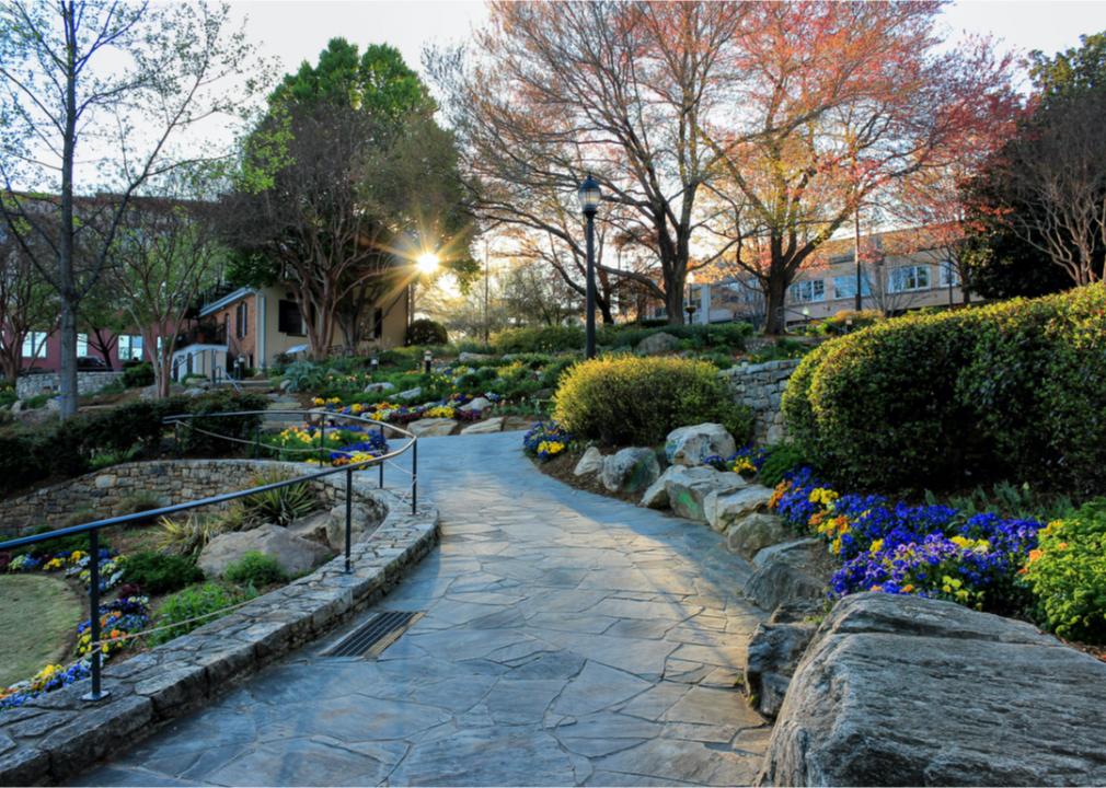
About
Polk County, North Carolina rests in the foothills of the Blue Ridge, where valleys, farms, and quiet towns reflect a strong rural character. Columbus, the county seat, anchors civic life, while Tryon is known for its equestrian culture and artistic traditions. Together, these communities maintain a balance of heritage and small-town spirit.
Agriculture, horse farms, and vineyards shape much of the local livelihood, supported by tourism drawn to the county’s mountain scenery. Outdoor recreation and cultural festivals provide opportunities that strengthen both the economy and community ties. Polk County stands as a place where landscape, tradition, and enterprise work hand in hand.
Where is Polk County?
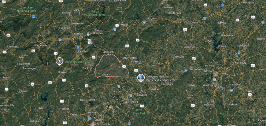
Polk County is located in southwestern North Carolina along the border with South Carolina. It covers about 239 square miles, making it one of the state’s smaller counties in area. Columbus, the county seat, sits near the center along U.S. Highway 74 at the foot of the Blue Ridge Mountains.
Interstate 26 crosses the county, connecting it north to Asheville and south to Spartanburg, South Carolina. Other towns include Tryon on the southern border and Saluda in the northern highlands. Polk County’s position gives it direct mountain-to-midlands access between North Carolina and South Carolina.
#16. Pitt County, North Carolina
– Overall Rank: 225
– Population: 171,196
– Median household income: $54,915
– Median home value: $178,700 (51% own)
– Median rent: $911 (49% rent)
– Top public schools: Innovation Early College High (grade A), Early College High School (grade A), Hope Middle School (grade A)
– Top private schools: The Oakwood School (grade A+), John Paul II Catholic High School (grade A), Greenville Christian Academy (grade B+)
– Top places: Winterville (grade A), Greenville (grade A minus), Ayden (grade B+)
You may also like: Best amusement parks in North Carolina
About
Pitt County, North Carolina sits in the eastern part of the state, where flat coastal plains support both farming communities and expanding urban life. Greenville, the county seat, has grown into a regional hub, anchored by East Carolina University and a strong medical presence. Smaller towns across the county maintain ties to the land through agriculture and local traditions.
Health care, education, and manufacturing are major drivers of the local economy, while farming continues to play a steady role. Cultural events, university programs, and festivals bring together residents from across the region. Pitt County reflects a blend of rural heritage and modern growth, shaped by both its farmland and its expanding urban center.
Where is Pitt County?
Pitt County is in eastern North Carolina, bordered by Greene County to the west, Beaufort County to the east, and Edgecombe County to the north. It spans about 655 square miles across the coastal plain. Greenville, the county seat and largest city, is located near the center along the Tar River.
The county is served by U.S. Highways 13, 264, and 258, providing routes toward Raleigh, Wilson, and Washington, NC. Smaller communities include Farmville to the west, Ayden to the south, and Bethel to the north. Pitt County’s location places it as a regional hub in the coastal plain, with strong highway connections to nearby urban centers.
#15. Watauga County, North Carolina
– Overall Rank: 223
– Population: 54,540
– Median household income: $50,034
– Median home value: $283,000 (61% own)
– Median rent: $1,067 (39% rent)
– Top public schools: Blowing Rock Elementary School (grade A), Parkway Elementary School (grade A), Two Rivers Community School (grade A)
– Top private schools: Grace Academy (grade unavailable)
– Top places: Boone (grade A minus), Blowing Rock Township (grade A), Blue Ridge Township (grade A)
About
Watauga County, North Carolina rises high in the Blue Ridge Mountains, where ridges, valleys, and winding rivers frame its landscape. Boone, the county seat, is both a historic mountain town and the home of Appalachian State University, giving the area an educational and cultural presence. Small communities scattered through the county carry forward long-standing traditions of farming, crafts, and music.
Tourism and outdoor recreation play a major role, with hiking, skiing, and the Blue Ridge Parkway drawing visitors year-round. Local businesses, higher education, and agriculture also support a diverse economy. Watauga County embodies a mountain identity where natural beauty, cultural heritage, and modern opportunity come together.
Where is Watauga County?

Watauga County sits in the northwestern corner of North Carolina, sharing its northern boundary with Tennessee and touching Ashe and Avery counties. It spans about 312 square miles of rugged Appalachian terrain in the Blue Ridge Mountains. Boone, the county seat and home to Appalachian State University, lies near the center along U.S. Highways 321 and 421.
The county is traversed by U.S. Highways 421 and 321, which connect Boone to cities like Winston-Salem and Hickory, as well as to Johnson City, Tennessee. Blowing Rock and Seven Devils are other notable communities situated in the mountain valleys and ridges. Watauga County’s location places it high in the Blue Ridge, with mountain passes linking North Carolina to eastern Tennessee.
#14. Catawba County, North Carolina
– Overall Rank: 202
– Population: 161,011
– Median household income: $62,070
– Median home value: $194,000 (71% own)
– Median rent: $866 (29% rent)
– Top public schools: Challenger Early College High School (grade A), Discovery High School (grade A), Shuford Elementary School (grade A)
– Top private schools: University Christian High School (grade A), Hickory Christian Academy (grade B), Tabernacle Christian School (grade B)
– Top places: Hickory (grade A minus), St. Stephens (grade A minus), Newton (grade A minus)
🔥 Would you like to save this?
About
Catawba County, North Carolina lies in the state’s Piedmont region, where rolling hills and the Catawba River have shaped settlement and industry for generations. Hickory, the county seat, developed as a hub of furniture-making and craftsmanship, giving the area a lasting reputation for skilled work. Smaller towns across the county add to its identity with their own traditions and histories.
Manufacturing remains important, though the economy has expanded into technology, health care, and education. Community life is highlighted by festivals, markets, and cultural events that showcase both heritage and innovation. Catawba County reflects a balance of industrious spirit and modern growth, carrying forward its reputation for resilience and adaptability.
Where is Catawba County?
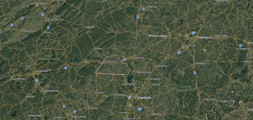
Catawba County is in the western Piedmont of North Carolina, bordered by Caldwell County to the north, Lincoln County to the south, and Iredell County to the east. It spans about 414 square miles of rolling terrain along the Catawba River. Newton, the county seat, sits near the center, while Hickory is the largest city and economic hub.
Interstate 40 runs east–west through the county, connecting it to Winston-Salem and Asheville. U.S. Highways 321 and 70 provide north–south and cross-county routes, linking towns such as Conover, Claremont, and Maiden. Catawba County’s location gives it strong regional access within the Piedmont and ties to both mountain and urban corridors.
#13. Iredell County, North Carolina
– Overall Rank: 196
– Population: 187,839
– Median household income: $73,103
– Median home value: $261,200 (72% own)
– Median rent: $1,105 (28% rent)
– Top public schools: Collaborative College for Technology & Leadership (CCTL) (grade A), Pine Lake Preparatory School (grade A), Rocky River Elementary School (grade A)
– Top private schools: Woodlawn School (grade A), Liberty Preparatory Christian Academy (grade B+), Southview Christian School (grade B)
– Top places: Mooresville (grade A), Troutman (grade A minus), Statesville (grade B+)
About
Iredell County, North Carolina stretches through the Piedmont, where farmland, small towns, and growing suburban communities shape its character. Statesville, the county seat, reflects a long history tied to trade routes and agriculture, while Mooresville has become known as a center for motorsports and commerce. Together, these communities represent both tradition and rapid growth.
The local economy blends farming and manufacturing with strong sectors in healthcare, retail, and auto racing industries. Lake Norman provides recreation and tourism opportunities that strengthen community life and attract new residents. Iredell County embodies a mix of heritage and modern expansion, rooted in its land while open to innovation.
Where is Iredell County?

Iredell County is located in the Piedmont region of North Carolina, bordered by Yadkin County to the north, Rowan County to the east, and Catawba County to the west. It covers about 597 square miles of farmland, foothills, and lakeshore. Statesville, the county seat, sits near the center along the intersection of Interstates 40 and 77.
Mooresville, in the southern part of the county, lies along Lake Norman and has direct access to Charlotte via I-77. Other communities include Troutman near the lake and Harmony to the north. Iredell County’s position provides both interstate connectivity and proximity to major metro areas, while still maintaining rural and lakeside settings.
#12. Union County, North Carolina
– Overall Rank: 158
– Population: 240,109
– Median household income: $95,533
– Median home value: $336,600 (83% own)
– Median rent: $1,274 (17% rent)
– Top public schools: Marvin Ridge High School (grade A+), Weddington High School (grade A+), Central Academy of Technology & Arts (grade A+)
– Top private schools: Metrolina Christian Academy (grade B+), Arborbrook Christian Academy (grade B+), Shining Light Baptist Academy (grade B+)
– Top places: Marvin (grade A+), Weddington (grade A+), Waxhaw (grade A)

About
Union County, North Carolina sits in the south-central Piedmont, where farmland, small towns, and suburban neighborhoods create a diverse landscape. Monroe, the county seat, carries a historic downtown and long-standing ties to agriculture, while other communities have grown quickly with the expansion of the Charlotte metro area. The county reflects both deep rural traditions and the influence of modern development.
Agriculture—especially poultry, livestock, and crop production—remains a foundation of local life, even as manufacturing, retail, and service industries expand. Parks, festivals, and cultural events add to a strong sense of community across its towns. Union County represents a place where growth and heritage meet, shaping an identity rooted in both land and opportunity.
Where is Union County?
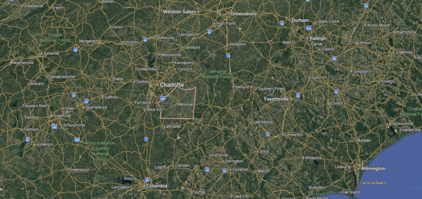
Union County is in south-central North Carolina, directly bordering South Carolina along its southern edge. It spans about 640 square miles of rolling farmland, suburban corridors, and growing towns. Monroe, the county seat, is located near the center along U.S. Highway 74, about 25 miles southeast of Charlotte.
The county is crossed by major routes including U.S. Highway 74 and Interstate 485, which link it closely with the Charlotte metropolitan area. Other communities include Indian Trail to the northwest, Waxhaw near the South Carolina line, and Wingate to the east. Union County’s location makes it both a suburban extension of Charlotte and a connector between North Carolina and South Carolina.
#11. Buncombe County, North Carolina
– Overall Rank: 117
– Population: 269,449
– Median household income: $66,531
– Median home value: $328,900 (64% own)
– Median rent: $1,209 (36% rent)
– Top public schools: Martin L. Nesbitt, Jr. Discovery Academy (grade A), Evergreen Community Charter School (grade A), Buncombe County Early College (grade A)
– Top private schools: Christ School (grade A+), Asheville School (grade A+), Carolina Day School (grade A)
– Top places: Royal Pines (grade A), Biltmore Forest (grade A), Black Mountain (grade A)
You may also like: Counties with the highest rates of high blood pressure in North Carolina
About
Buncombe County, North Carolina lies in the Blue Ridge Mountains, where valleys and ridgelines have long shaped settlement and culture. Asheville, the county seat, is known for its historic architecture, thriving arts scene, and role as a gateway to the surrounding mountains. Smaller towns and rural communities add depth with traditions tied to farming, crafts, and music.
Tourism, healthcare, and education drive much of the county’s economy, supported by manufacturing and local businesses. Festivals, markets, and outdoor recreation connect residents and visitors to both heritage and landscape. Buncombe County reflects a mountain identity that balances tradition with creativity, making it one of North Carolina’s most distinctive regions.
Where is Buncombe County?
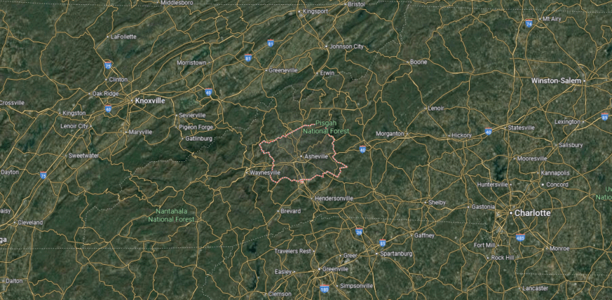
Buncombe County lies in western North Carolina, bordered by Madison County to the north, McDowell County to the east, and Henderson County to the south. It spans about 660 square miles of Appalachian Mountains and river valleys. Asheville, the county seat and largest city in western North Carolina, sits near the center at the junction of Interstates 26 and 40.
Other communities include Black Mountain to the east, Weaverville to the north, and Arden to the south. The county is defined by the French Broad River running through its heart and by its access to major mountain passes. Buncombe County’s location makes it a transportation and cultural hub, linking mountain communities with the broader region.
#10. New Hanover County, North Carolina
– Overall Rank: 104
– Population: 228,134
– Median household income: $67,515
– Median home value: $320,000 (60% own)
– Median rent: $1,249 (40% rent)
– Top public schools: Isaac M. Bear High School (grade A+), Wilmington Early College High School (grade A), Cape Fear Center for Inquiry (grade A)
– Top private schools: Cape Fear Academy (grade A+), Coastal Christian High School (grade B), Wilmington Christian Academy (grade B minus)
– Top places: Ogden (grade A), Wrightsville Beach (grade A), Murraysville (grade A minus)
About
New Hanover County, North Carolina rests along the southeastern coast, where the Cape Fear River meets the Atlantic Ocean. Wilmington, the county seat, anchors the area with its historic port, film industry presence, and lively downtown along the riverfront. Surrounding beach communities add to the county’s identity, blending coastal living with tourism and tradition.
Shipping, healthcare, and education provide a strong economic base, while tourism and film production continue to expand opportunities. Festivals, cultural events, and waterfront gatherings highlight the region’s character and strengthen community life. New Hanover County represents a coastal setting where history, economy, and culture flow together like the tides.
Where is New Hanover County?
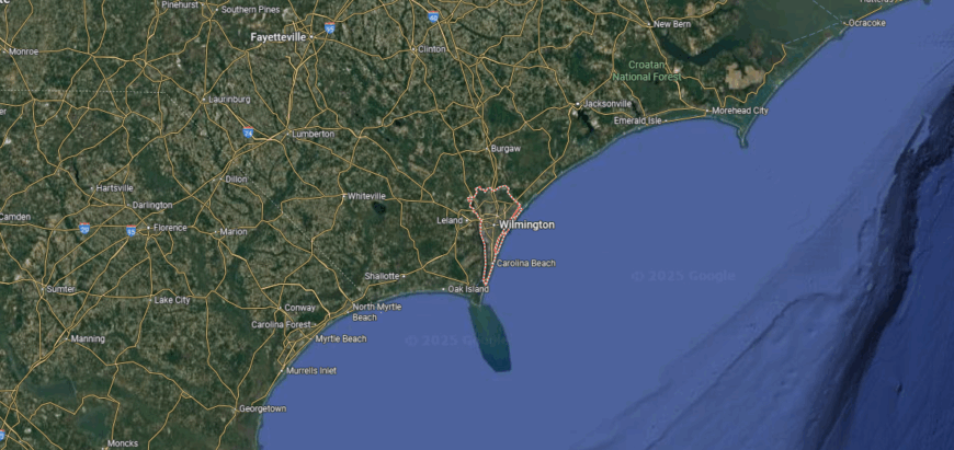
New Hanover County is located on the southeastern coast of North Carolina, bordered by Pender County to the north and Brunswick County to the west. It is one of the state’s smaller counties by area, covering just 328 square miles, much of it along the Atlantic shoreline. Wilmington, the county seat, sits inland along the Cape Fear River about 20 miles from the ocean.
U.S. Highways 17, 74, and 421 connect the county to other parts of the state, while Wrightsville Beach, Carolina Beach, and Kure Beach line its eastern edge. The county’s compact size and coastal location give it direct access to both river and ocean routes. New Hanover County serves as a coastal hub, linking southeastern North Carolina to inland highways and Atlantic ports.
#9. Guilford County, North Carolina
– Overall Rank: 94
– Population: 539,557
– Median household income: $62,880
– Median home value: $215,700 (60% own)
– Median rent: $1,049 (40% rent)
– Top public schools: The Early College at Guilford (grade A+), Weaver Academy for Performing & Visual Arts and Advanced Technology (grade A+), Summerfield Charter Academy (grade A+)
– Top private schools: Greensboro Day School (grade A+), Caldwell Academy (grade A), Oak Ridge Military Academy (grade A)
– Top places: Summerfield (grade A+), Stokesdale (grade A), Jamestown (grade A)
About
Guilford County, North Carolina sits in the heart of the Piedmont, where rolling hills and crossroads have long made it a center of trade and settlement. Greensboro, the county seat, carries a legacy of Revolutionary history and civil rights, while High Point has gained worldwide recognition as a hub of furniture design and production. Smaller towns across the county contribute their own traditions and community character.
The economy is built on a diverse base of manufacturing, higher education, healthcare, and international trade, reflecting both historic industries and modern growth. Universities and cultural institutions add depth, supporting innovation while enriching local life. Guilford County stands as a place where history and progress intersect, giving it a strong role in shaping North Carolina’s identity.
Where is Guilford County?
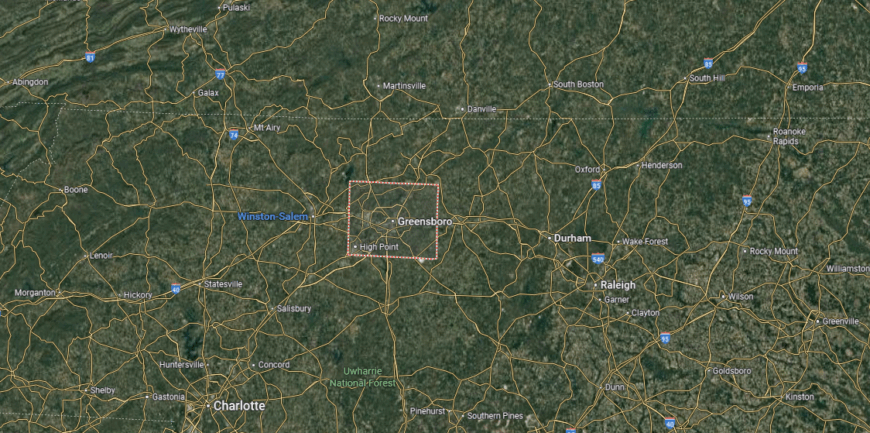
Guilford County sits in north-central North Carolina, bordered by Rockingham County to the north, Alamance County to the east, and Davidson County to the southwest. It spans about 657 square miles of Piedmont terrain, with Greensboro as the county seat and largest city. High Point, another major city, lies in the southern portion and extends into neighboring counties.
The county is crossed by Interstates 40, 85, and 73, making it one of the most connected regions in the state. Smaller communities include Jamestown between Greensboro and High Point, Oak Ridge to the northwest, and Gibsonville along the Alamance County line. Guilford County’s central location and extensive highway network position it as a major transportation and economic hub within the Piedmont.
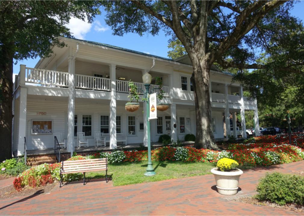
#8. Moore County, North Carolina
– Overall Rank: 88
– Population: 100,759
– Median household income: $77,981
– Median home value: $284,000 (77% own)
– Median rent: $1,084 (23% rent)
– Top public schools: The Academy of Moore County (grade A+), West End Elementary School (grade A), McDeeds Creek Elementary School (grade A)
– Top private schools: The O’Neal School (grade A+), Sandhills Classical Christian School (grade A minus), Saint John Paul II Catholic School (grade unavailable)
– Top places: Pinehurst (grade A+), Southern Pines (grade A), Aberdeen (grade A)

About
Moore County, North Carolina is known for its sandy soils, longleaf pines, and a history rooted in both agriculture and early settlement. Carthage, the county seat, reflects its traditional civic life, while Southern Pines and Pinehurst are recognized worldwide for their golf resorts and cultural offerings. The county blends small-town character with international appeal.
Tourism tied to golf, equestrian events, and outdoor recreation fuels much of the local economy, supported by healthcare, education, and retail. Farming, especially tobacco and livestock, continues to play a role in rural areas. Moore County represents a unique mix of heritage, recreation, and modern growth that gives it a distinct place in North Carolina.
Where is Moore County?
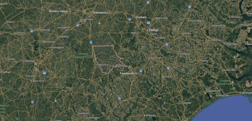
Moore County is in the south-central part of North Carolina, bordered by Randolph County to the north, Harnett County to the east, and Richmond County to the southwest. It covers about 706 square miles of Sandhills terrain, known for rolling pine forests and sandy soils. Carthage, the county seat, lies near the geographic center along U.S. Highway 15/501.
The county is served by major routes including U.S. Highways 1, 15/501, and 220, connecting it to Raleigh, Fayetteville, and Charlotte. Southern Pines and Pinehurst anchor the eastern side, recognized as regional centers for golf and tourism, while Robbins lies in the northwestern section. Moore County’s position links the Sandhills to both the Piedmont and the coastal plain.
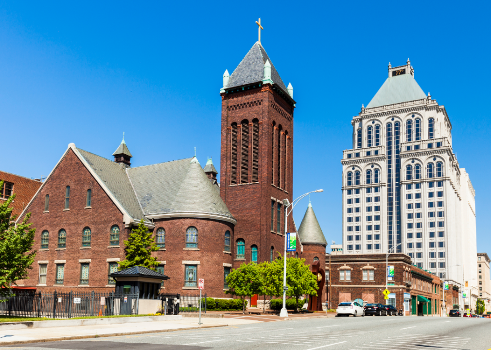
#7. Forsyth County, North Carolina
– Overall Rank: 78
– Population: 383,739
– Median household income: $61,229
– Median home value: $205,700 (62% own)
– Median rent: $969 (38% rent)
– Top public schools: Early College of Forsyth (grade A+), Atkins Academic & Technology High School (grade A), Ronald W. Reagan High School (grade A)
– Top private schools: Salem Academy (grade A+), Forsyth Country Day School (grade A+), Calvary Day School (grade A+)
– Top places: Lewisville (grade A), Clemmons (grade A), Winston-Salem (grade A)
About
Forsyth County, North Carolina lies in the Piedmont region, where rolling hills and growing urban centers shape its identity. Winston-Salem, the county seat, carries a dual legacy as both an industrial hub—once driven by tobacco and textiles—and a modern center for arts, medicine, and higher education. The surrounding towns and rural areas maintain ties to farming and community traditions.
Today, research, healthcare, and education lead the local economy, alongside a strong presence in technology and finance. Festivals, theaters, and museums highlight Winston-Salem’s reputation as the “City of Arts and Innovation.” Forsyth County reflects a balance of industrial heritage and forward-looking growth, blending tradition with creativity and resilience.
Where is Forsyth County?
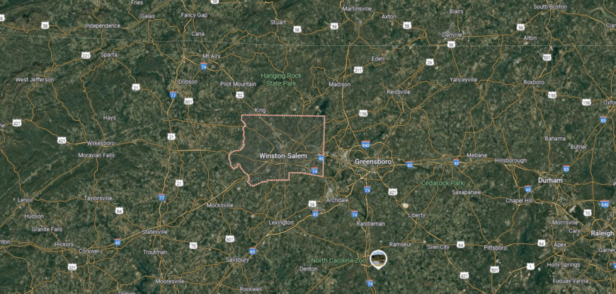
Forsyth County is in the northwestern Piedmont of North Carolina, bordered by Stokes County to the north, Guilford County to the east, and Davidson County to the south. It spans about 413 square miles of gently rolling terrain. Winston-Salem, the county seat and largest city, lies near the center and serves as the cultural and economic hub.
Interstate 40, Interstate 285, and U.S. Highway 52 cross the county, providing direct routes to Greensboro, Charlotte, and Mount Airy. Other communities include Kernersville to the east, Clemmons to the southwest, and Rural Hall in the north. Forsyth County’s location places it in a key corridor of the Piedmont Triad, with strong connections to surrounding urban centers.
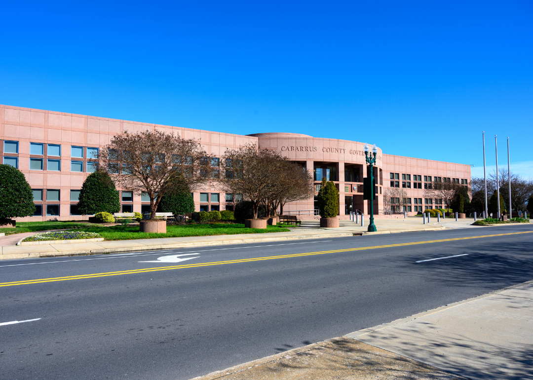
#6. Cabarrus County, North Carolina
– Overall Rank: 69
– Population: 226,396
– Median household income: $83,828
– Median home value: $281,600 (73% own)
– Median rent: $1,185 (27% rent)
– Top public schools: Cabarrus-Kannapolis Early College High School (grade A), Cox Mill Elementary School (grade A), Harris Road Middle School (grade A)
– Top private schools: Cannon School (grade A), HOPE Academy (grade A), Christ the King Catholic High School (grade A minus)
– Top places: Harrisburg (grade A+), Concord (grade A), Kannapolis (grade B+)
You may also like: Best private high schools in North Carolina
About
Cabarrus County, North Carolina rests in the south-central Piedmont, where farmland and fast-growing towns create a landscape of both tradition and change. Concord, the county seat, anchors civic life and commerce while holding historic ties to textile mills and regional trade. Other communities, including Kannapolis, add depth through their own history and revitalization.
Motorsports, healthcare, and retail play a major role in shaping the local economy, with Charlotte Motor Speedway standing as a defining landmark. Agriculture continues to contribute, though manufacturing and research have become increasingly important. Cabarrus County represents a blend of heritage and modern growth, where history, industry, and community intersect.
Where is Cabarrus County?
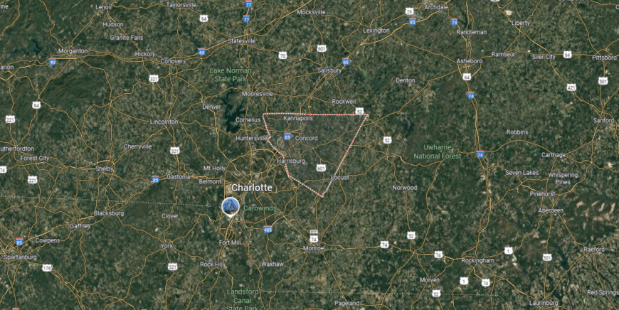
Cabarrus County is located in the south-central Piedmont of North Carolina, bordered by Rowan County to the north, Stanly County to the east, and Mecklenburg County to the southwest. It covers about 364 square miles of rolling countryside and growing suburban areas. Concord, the county seat, lies near the center along Interstate 85, about 25 miles northeast of Charlotte.
The county is crossed by I-85, which serves as its main transportation corridor, linking it directly to Charlotte, Greensboro, and Durham. Other communities include Kannapolis in the northern section, Harrisburg near the Mecklenburg line, and Mount Pleasant to the east. Cabarrus County’s location ties it closely to the Charlotte metropolitan region while still maintaining strong local hubs of its own.
#5. Chatham County, North Carolina
– Overall Rank: 66
– Population: 76,754
– Median household income: $84,222
– Median home value: $373,300 (80% own)
– Median rent: $995 (20% rent)
– Top public schools: Woods Charter School (grade A+), Willow Oak Montessori (grade A), Chatham Grove Elementary School (grade A)
– Top private schools: Thales Academy Pittsboro Pre-K-8 (grade unavailable), Haw River Christian Academy (grade unavailable), Holy Youth Christian Academy (grade unavailable)
– Top places: Fearrington Village (grade A), Pittsboro (grade A minus), Siler City (grade B)

About
Chatham County, North Carolina lies where the Piedmont’s rolling hills meet the headwaters of major rivers, giving it a landscape of forests, farmland, and small towns. Pittsboro, the county seat, reflects both historic roots and a growing role as a cultural and civic center. The county has long carried a balance of agricultural heritage and community traditions.
In recent decades, growth has brought new energy through advanced manufacturing, research, and development tied to the nearby Triangle region. Local farms, markets, and festivals continue to highlight Chatham’s agricultural character, even as new industries shape its economy. Chatham County embodies a meeting point of tradition and innovation, where rural life and modern progress move together.
Where is Chatham County?
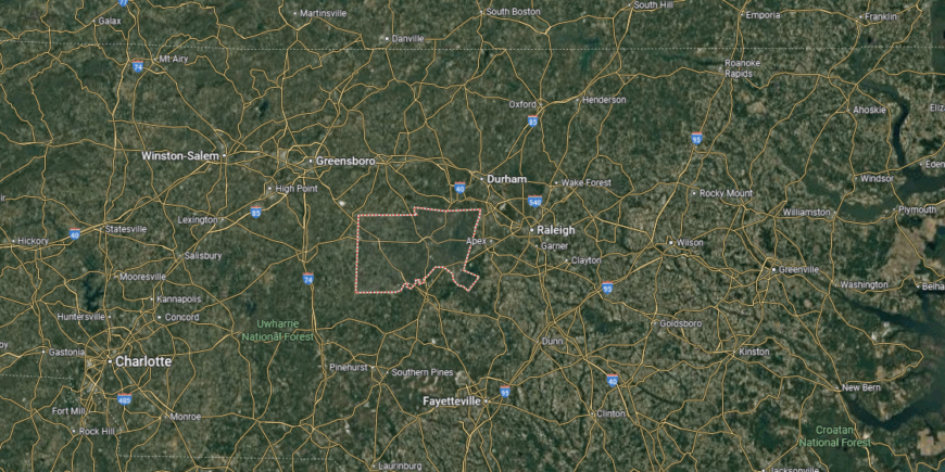
Chatham County lies in central North Carolina, bordered by Orange County to the north, Wake County to the east, and Randolph County to the west. It spans about 710 square miles, with a landscape of rolling Piedmont hills and river valleys. Pittsboro, the county seat, is located near the center along U.S. Highway 64.
The county is crossed by major routes including U.S. Highways 64 and 15/501, linking it to Raleigh, Chapel Hill, and Sanford. Other communities include Siler City in the west and Goldston in the south. Chatham County’s central position places it at the edge of the Research Triangle while maintaining ties to surrounding rural areas.
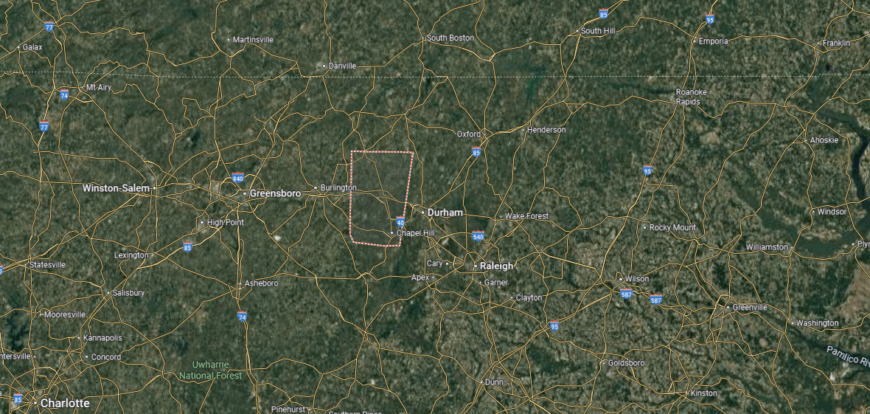
#4. Durham County, North Carolina
– Overall Rank: 49
– Population: 325,101
– Median household income: $74,927
– Median home value: $311,300 (55% own)
– Median rent: $1,301 (45% rent)
– Top public schools: North Carolina School of Science and Mathematics (grade A+), Research Triangle High School (grade A), Middle College High School at DTCC (grade A)
– Top private schools: Durham Academy (grade A+), Trinity School of Durham & Chapel Hill (grade A+), Camelot Academy (grade A+)
– Top places: Durham (grade A), Gorman (grade C+), Triangle Township (grade A+)

About
Durham County, North Carolina centers on the city of Durham, where a history built on tobacco and textiles has given way to education, research, and technology. The county’s identity is closely tied to Duke University and the Research Triangle Park, which together anchor both cultural life and economic innovation. Beyond the city, smaller communities reflect a blend of rural heritage and steady growth.
Arts, medicine, and research drive much of the local economy, supported by a diverse mix of businesses and entrepreneurs. Festivals, music, and food traditions highlight the county’s creative spirit and cultural depth. Durham County represents a place where history and innovation intersect, shaping a dynamic and enduring character.
Where is Durham County?
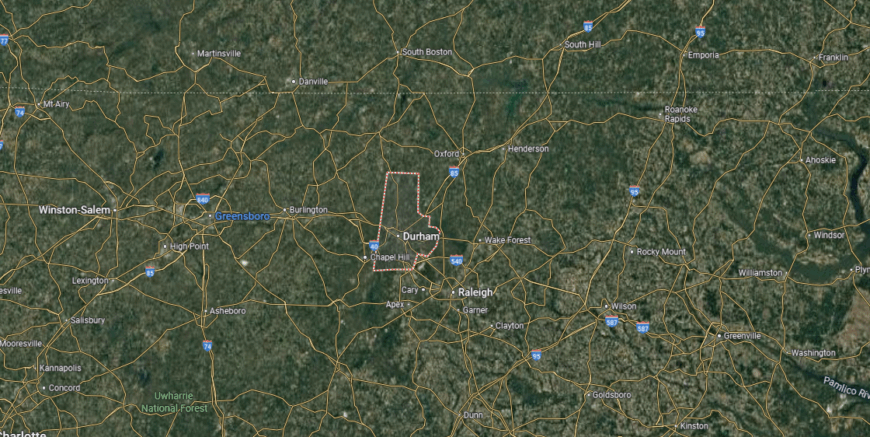
Durham County is in north-central North Carolina, bordered by Person County to the north, Orange County to the west, and Wake County to the south and east. It covers about 298 square miles, making it one of the smaller counties in the state by land area. Durham, the county seat and largest city, lies near the center along Interstate 85 and U.S. Highway 15/501.
The county is crossed by I-85 and the Durham Freeway (NC 147), giving it direct links to Raleigh, Chapel Hill, and points beyond. Other communities include Rougemont in the north and Bahama near the Falls Lake area. Durham County’s location places it firmly within the Research Triangle, with close connections to both academic centers and regional highways.
#3. Mecklenburg County, North Carolina
– Overall Rank: 39
– Population: 1,115,403
– Median household income: $79,265
– Median home value: $334,700 (56% own)
– Median rent: $1,413 (44% rent)
– Top public schools: Ardrey Kell High School (grade A+), Metrolina Regional Scholars Academy (grade A+), Charlotte Engineering Early College (grade A+)
– Top private schools: Providence Day School (grade A+), Charlotte Country Day School (grade A+), Charlotte Latin School (grade A+)
– Top places: Davidson (grade A+), Dilworth (grade A+), Ballantyne East (grade A+)
About
Mecklenburg County, North Carolina is home to Charlotte, the state’s largest city and a major center of commerce in the Southeast. Its early history was shaped by farming, trade routes, and Revolutionary heritage, but over time the county became defined by banking, business, and urban growth. Smaller surrounding towns add to its character with their own traditions and community ties.
Banking and finance form the backbone of the economy, giving Charlotte its reputation as a national financial hub. Healthcare, education, and technology also play vital roles, while sports, arts, and cultural institutions enrich civic life. Mecklenburg County reflects a balance of rapid metropolitan growth and regional history, shaping an identity that influences the state as a whole.
Where is Mecklenburg County?
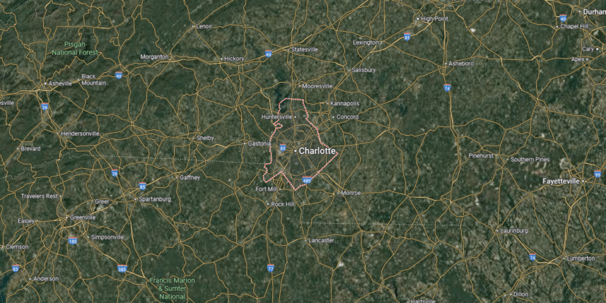
Mecklenburg County is located in south-central North Carolina, sharing its southern border with South Carolina. It spans about 546 square miles of Piedmont terrain, blending urban development with rolling hills. Charlotte, the county seat and the state’s largest city, lies near the center at the crossroads of Interstates 77 and 85.
The county’s highway system includes I-77 running north–south, I-85 running northeast–southwest, and I-485 encircling Charlotte as a beltway. Other communities include Huntersville and Cornelius to the north along Lake Norman, Matthews to the southeast, and Pineville near the South Carolina line. Mecklenburg County’s location makes it the central hub of commerce and transportation in the Carolinas.
#2. Orange County, North Carolina
– Overall Rank: 25
– Population: 145,919
– Median household income: $85,785
– Median home value: $395,600 (65% own)
– Median rent: $1,316 (35% rent)
– Top public schools: The Expedition School (grade A+), Chapel Hill High School (grade A), Glenwood Elementary School (grade A)
– Top private schools: Carolina Friends School (grade A+), Emerson Waldorf School (grade A+), St. Thomas More Catholic School (grade unavailable)
– Top places: Chapel Hill (grade A+), Carrboro (grade A+), Hillsborough (grade A)

About
Orange County, North Carolina rests in the central Piedmont, where rolling hills and historic towns shape both its culture and landscape. Hillsborough, the county seat, reflects its colonial roots with preserved architecture and a strong sense of heritage. Chapel Hill, home to the University of North Carolina, brings an academic and artistic influence that defines much of the county’s identity.
Education and healthcare anchor the economy, supported by research, technology, and small businesses tied to the nearby Triangle region. Farmers’ markets, festivals, and music traditions highlight a strong connection to community and culture. Orange County blends history, learning, and innovation, creating a character that is both rooted and forward-looking.
Where is Orange County?
Orange County is in north-central North Carolina, bordered by Person County to the north, Durham County to the east, and Alamance County to the west. It spans about 401 square miles of rolling Piedmont terrain. Hillsborough, the county seat, lies near the center along Interstate 85 and U.S. Highway 70.
Chapel Hill and Carrboro anchor the southern portion, with the University of North Carolina at Chapel Hill serving as a major landmark. Other communities include Efland along I-40 and Cedar Grove in the northern section. Orange County’s location ties it to both the Research Triangle and the Triad, positioned between Raleigh, Durham, and Greensboro.
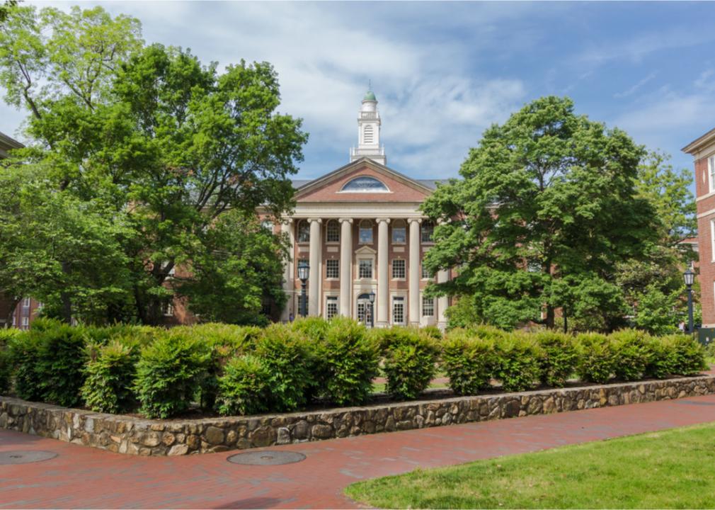
#1. Wake County, North Carolina
– Overall Rank: 3
– Population: 1,132,103
– Median household income: $96,734
– Median home value: $385,700 (64% own)
– Median rent: $1,412 (36% rent)
– Top public schools: Raleigh Charter High School (grade A+), Green Level High School (grade A+), Wake Early College of Health & Sciences (grade A+)
– Top private schools: Cary Academy (grade A+), Ravenscroft School (grade A+), Saint Mary’s School (grade A+)
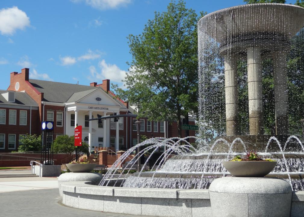
– Top places: Cary (grade A+), Morrisville (grade A+), Apex (grade A+)

Wake County, North Carolina sits at the heart of the Research Triangle, where rolling Piedmont hills meet one of the fastest-growing metropolitan regions in the South. Raleigh, the county seat and state capital, anchors civic life with its universities, government institutions, and cultural presence. Surrounding towns contribute their own histories while benefiting from the county’s rapid development.
Technology, research, and education drive the local economy, supported by healthcare, finance, and a growing service sector. Parks, museums, and festivals add to the quality of life, creating a balance of innovation and community tradition. Wake County represents both the historic core of North Carolina’s government and a modern hub of opportunity.
Where is Wake County?
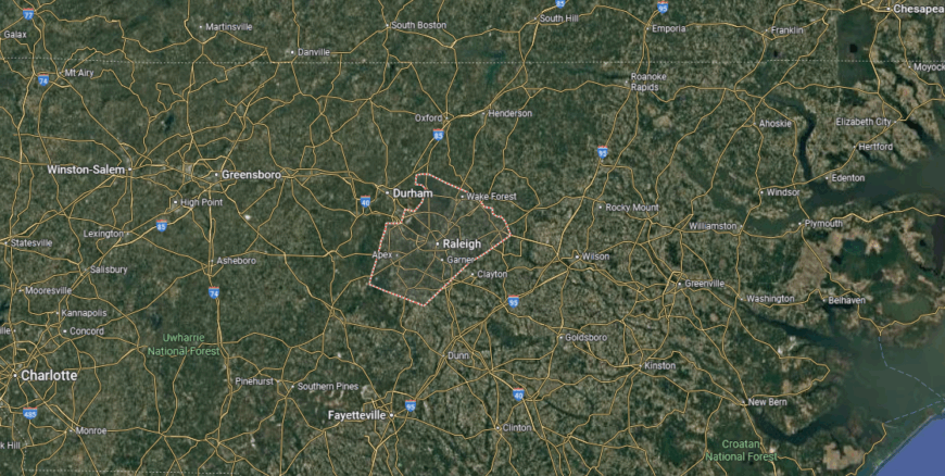
Wake County is located in north-central North Carolina, bordered by Franklin County to the northeast, Durham County to the northwest, and Johnston County to the southeast. It spans about 857 square miles of Piedmont landscape. Raleigh, the county seat and state capital, sits near the center, serving as a major political and economic hub.
The county is crossed by Interstates 40, 440, and 540, along with U.S. Highways 1 and 64, providing strong regional and interstate connections. Other communities include Cary, Apex, Garner, and Wake Forest, each part of the fast-growing Research Triangle area. Wake County’s location places it at the heart of central North Carolina, linking government, education, and commerce across the region.
This story features data reporting and writing by Elena Cox and is part of a series utilizing data automation across 50 states.
You may also like: Highest-rated wineries in North Carolina, according to Yelp
By Stacker