
Best counties to live in New Mexico
More counties in the United States experienced population growth in the last year, according to the latest Census data, even as pandemic-related moving trends begin to normalize.
In order to come up with the very specific design ideas, we create most designs with the assistance of state-of-the-art AI interior design software.
Counties in the South continued to experience growth, particularly in Florida, where 96% of its 67 counties gained new residents. Polk County, Florida, a suburb of Orlando, added the most, with 26,000 people moving there in 2023.
Meanwhile, counties in the Midwest and Northeast continued to lose population, but at slower rates than the year before. Some of the biggest losses were in counties home to large cities, including Cook County, Illinois (home of Chicago) and the boroughs of Brooklyn and Queens in New York.
Many counties are experiencing growth due to their job opportunities, education, or relatively affordable housing costs. Others are favored for their historic or well-designed downtowns or access to cultural opportunities.
Stacker compiled a list of the best counties to live in New Mexico using rankings from Niche. Niche ranks counties by various factors including public schools, educational attainment, cost of living, and housing.
Keep reading to see if your county made the list.
You may also like: Movies and TV shows casting in New Mexico
#22. Torrance County, New Mexico
– Overall Rank: Not ranked
– Population: 15,203
– Median household income: $50,727
– Median home value: $132,600 (83% own)
– Median rent: $731 (17% rent)
– Top public schools: Estancia Valley Classical Academy (grade B+), South Mountain Elementary School (grade B+), Route 66 Elementary School (grade B)
– Top places: Mountainair (grade B), Estancia (grade B minus), Willard (grade C)

About
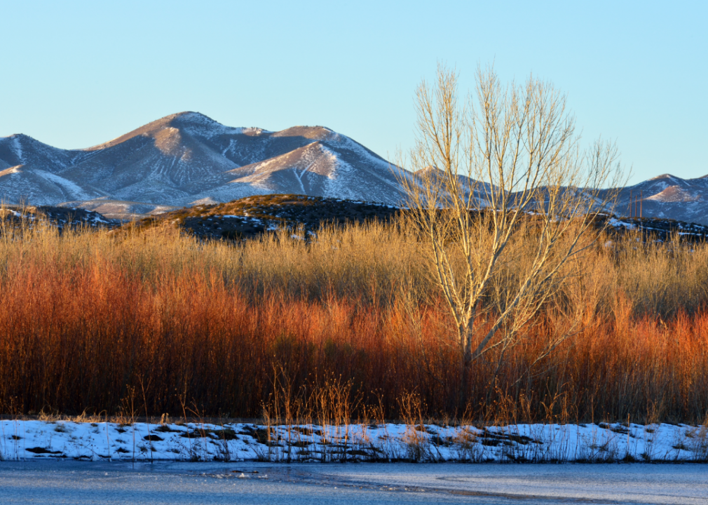
Torrance County, New Mexico is defined by its vast high desert plains, where open skies and rugged terrain frame the rhythm of daily life. Farming, ranching, and long-standing traditions provide the foundation of the county’s identity, linking residents closely to the land. Small towns and rural communities maintain a strong sense of connection through schools, churches, and civic gatherings.
Seasonal fairs, rodeos, and outdoor activities highlight the area’s agricultural roots and natural beauty. Families continue generational ties to the land, carrying forward a heritage of resilience and steady living. Torrance County reflects a grounded way of life, shaped by perseverance and a close-knit rural spirit.
Where is Torrance County?
Torrance County lies in central New Mexico, bordered by Santa Fe County to the north, Guadalupe County to the east, Lincoln County to the south, and Bernalillo County to the west. It is about 40 miles southeast of Albuquerque and 65 miles south of Santa Fe. The county spans roughly 60 miles north to south and 45 miles east to west, covering plains and portions of the Manzano Mountains.
Estancia serves as the county seat, located near the center of Torrance County. Other key towns include Moriarty to the north along Interstate 40 and Mountainair to the south near the mountain foothills. The county features agricultural lands, ranching areas, and historic sites such as the Salinas Pueblo Missions National Monument.
#21. San Juan County, New Mexico
– Overall Rank: Not ranked
– Population: 121,798
– Median household income: $50,734
– Median home value: $170,700 (70% own)
– Median rent: $894 (30% rent)
– Top public schools: San Juan College High School (grade A), Mesa Verde Elementary School (grade A), Heights Middle School (grade A minus)
– Top private schools: Grace Baptist Academy (grade A), Sacred Heart Catholic School (grade unavailable), Casa Montessori Preschool (grade unavailable)
– Top places: Farmington (grade B), Aztec (grade B minus), Spencerville (grade B minus)
About
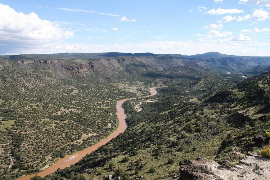
San Juan County, New Mexico is defined by its rivers, mesas, and the cultural layers that have shaped the region for centuries. The San Juan River and its fertile lands sustain both agriculture and community life while also tying into the county’s role in energy production. Its towns reflect a blend of Native traditions, Hispanic heritage, and the resilience of early settlers.
Recreation thrives in the area’s lakes, canyons, and open trails, offering residents daily connection to the land. Seasonal festivals and cultural gatherings bring together a diverse population, strengthening shared identity. San Juan County stands as a place where tradition and modern growth coexist within a striking landscape.
Where is San Juan County?
San Juan County is located in the northwestern corner of New Mexico, sharing borders with Colorado to the north and Arizona to the west. Covering over 5,500 square miles, it stands among the largest counties in the state. Farmington, the county seat, sits at the meeting point of the San Juan, Animas, and La Plata rivers, serving as the area’s commercial center.
To the east lies Rio Arriba County, while McKinley County forms its southern boundary. Towns such as Aztec, Bloomfield, and Shiprock add to its cultural and economic profile. The county is defined by its river valleys, desert mesas, and sites like the Bisti/De-Na-Zin Wilderness and the Four Corners Monument.
#20. Cibola County, New Mexico
– Overall Rank: Not ranked
– Population: 27,211
– Median household income: $49,866
– Median home value: $101,900 (71% own)
– Median rent: $753 (29% rent)
– Top public schools: Bluewater Elementary School (grade B+), Milan Elementary School (grade B minus), San Rafael Elementary School (grade C+)
– Top private schools: St. Teresa of Avila Catholic School (grade unavailable), St. Joseph Mission School (grade unavailable)
– Top places: Milan (grade C+), Grants (grade C+), North Acomita Village (grade C+)
About
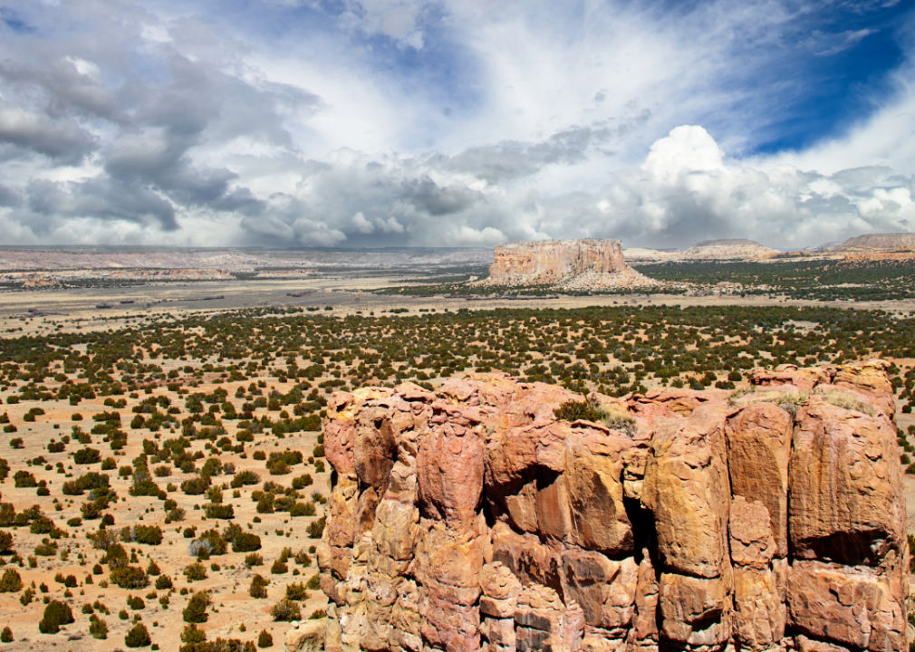
Cibola County, New Mexico is shaped by its striking mesas, forests, and the vast landscapes of the high desert. The county’s history is intertwined with Native communities, early settlers, and the natural resources that have long supported its people. Towns and villages maintain a balance between heritage and the demands of contemporary life.
Residents take part in cultural celebrations, outdoor exploration, and local traditions that keep community ties strong. From forested trails to wide-open plains, the land itself provides both livelihood and recreation. Cibola County reflects a connection to history and nature that continues to guide its identity today.
Where is Cibola County?
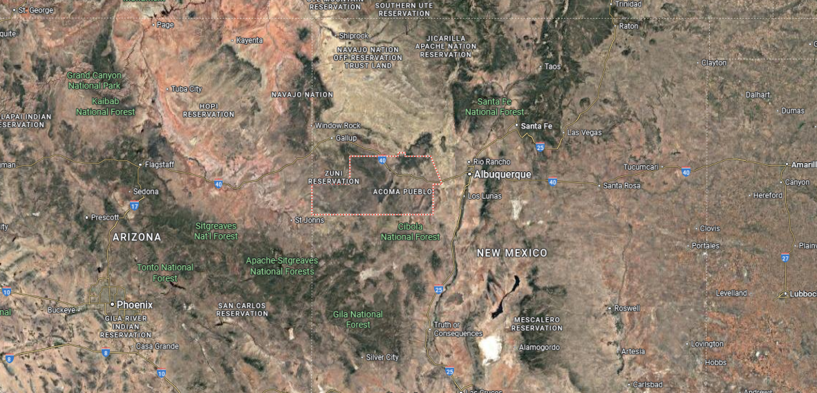
Cibola County is positioned in the west-central part of New Mexico, bordered by McKinley County to the northwest, Sandoval and Bernalillo counties to the north, and Valencia County to the east. It was created in 1981, making it one of the newest counties in the state. Grants, the county seat, lies along Interstate 40 about 80 miles west of Albuquerque and serves as the main hub for the region.
The county stretches across mesas, volcanic landscapes, and forested areas of the Cibola National Forest. Other towns include Milan just north of Grants and Laguna Pueblo in the eastern portion of the county. Notable features such as El Malpais National Monument and Mount Taylor highlight the mix of natural and cultural landmarks that define Cibola County.
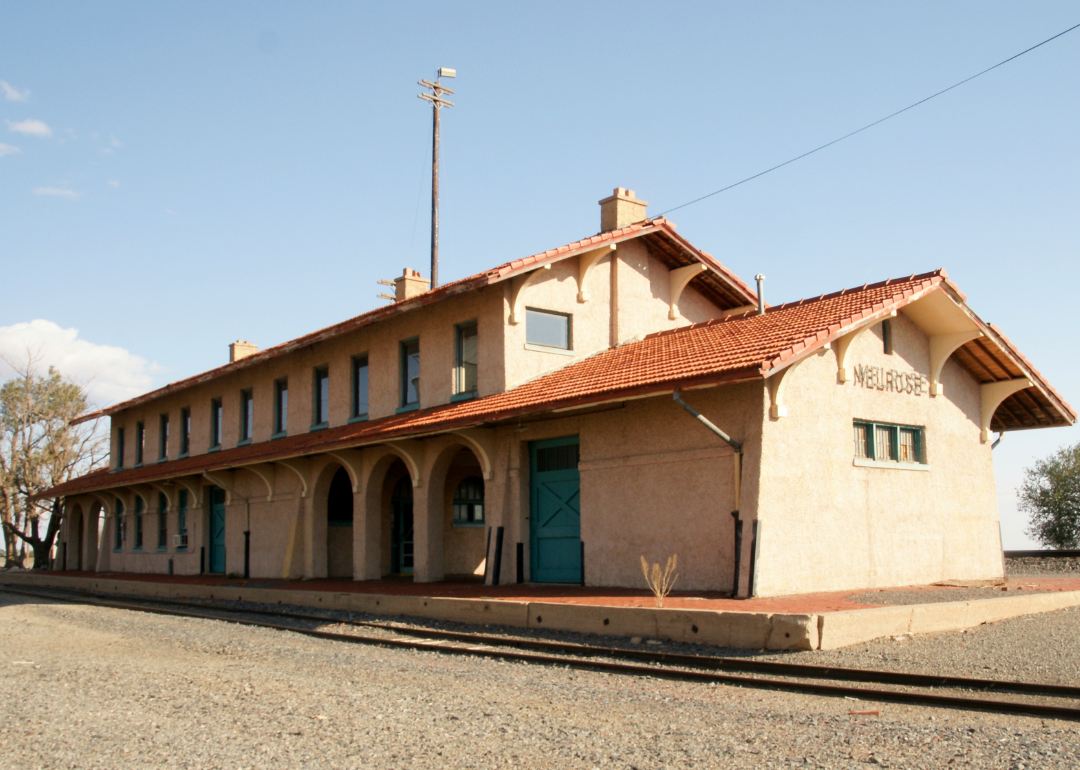
#19. Socorro County, New Mexico
– Overall Rank: Not ranked
– Population: 16,453
– Median household income: $40,699
– Median home value: $132,700 (75% own)
– Median rent: $702 (25% rent)
– Top public schools: Cottonwood Valley Charter School (grade B), Magdalena High School (grade B), Midway Elementary School (grade C+)
– Top places: Socorro (grade B), Magdalena (grade B minus), Alamillo (grade C minus)
About
Socorro County, New Mexico stretches across desert valleys and rugged mountains, where the Rio Grande provides a lifeline through the landscape. Its identity is rooted in centuries of farming, ranching, and traditions carried forward by Native and Hispanic communities. The county seat, Socorro, serves as a cultural and educational center, balancing small-town life with historic depth.
Outdoor life shapes much of the county, from hiking and birdwatching to working the land that has sustained generations. Festivals, local gatherings, and university events add variety to community rhythms. Socorro County reflects both resilience and adaptability, holding onto its heritage while embracing steady change.
Where is Socorro County?
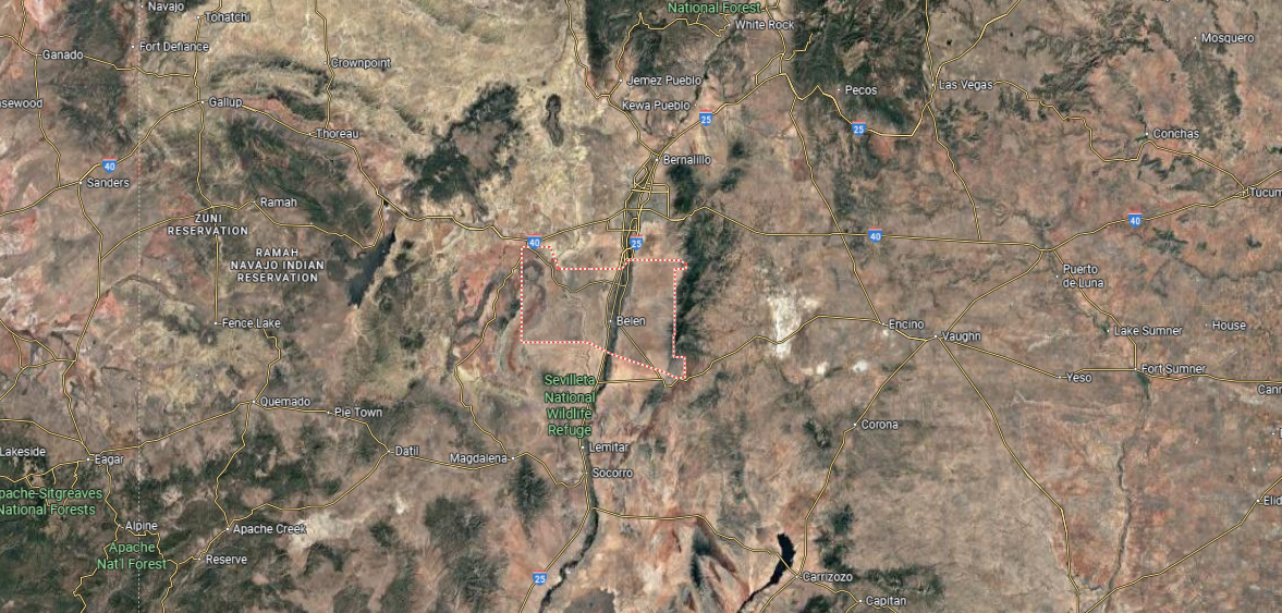
Socorro County is located in central New Mexico, extending from the Rio Grande Valley westward into rugged mountain terrain and desert basins. It is bordered by Valencia County to the north, Catron County to the west, and Sierra County to the south. The county seat, Socorro, lies about 75 miles south of Albuquerque along Interstate 25 and serves as its principal community.
The county spans over 6,600 square miles, making it one of the largest in New Mexico by area. Smaller towns such as Magdalena and San Antonio contribute to its regional character. Socorro County is notable for landmarks like the Bosque del Apache National Wildlife Refuge and the Very Large Array radio telescope on the Plains of San Agustin.
#18. Sierra County, New Mexico
– Overall Rank: Not ranked
– Population: 11,506
– Median household income: $35,256
– Median home value: $138,400 (73% own)
– Median rent: $729 (27% rent)
– Top public schools: Truth or Consequences Elementary School (grade B+), Truth or Consequences Middle School (grade B+), Sierra Elementary School (grade B)
– Top private schools:
– Top places: Truth or Consequences (grade B), Elephant Butte (grade B minus), Williamsburg (grade C+)
You may also like: Best public high schools in New Mexico
About
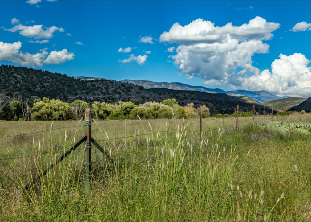
Sierra County, New Mexico is defined by its rugged desert ranges, winding rivers, and the wide expanses of open sky that frame daily life. The Rio Grande and Elephant Butte Lake anchor much of the county’s activity, supporting both recreation and community gathering. Small towns reflect a mix of historic character and a steady pace shaped by the surrounding landscape.
Residents and visitors alike are drawn to the area’s outdoor opportunities, from boating and fishing to exploring desert trails. Local events and seasonal festivals highlight traditions that keep communities closely connected. Sierra County carries a spirit of resilience, where natural beauty and heritage remain central to its identity.
Where is Sierra County?
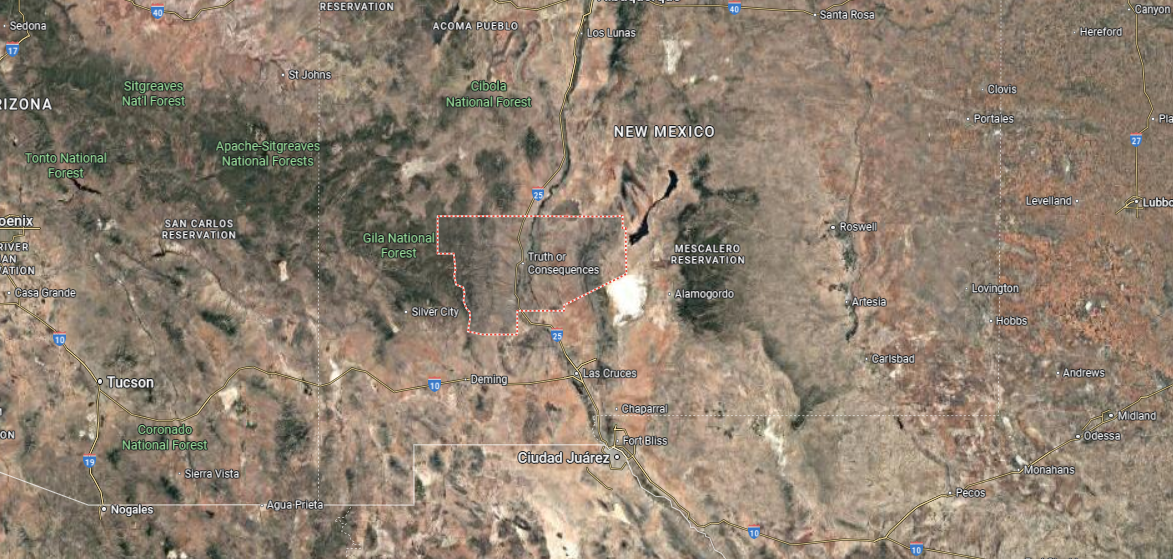
Sierra County sits in south-central New Mexico, bordered by Socorro County to the north, Doña Ana County to the south, and Lincoln County to the east. The county covers about 4,200 square miles, with terrain ranging from desert valleys to mountain ranges. Truth or Consequences, the county seat, lies along the Rio Grande and is about 150 miles south of Albuquerque.
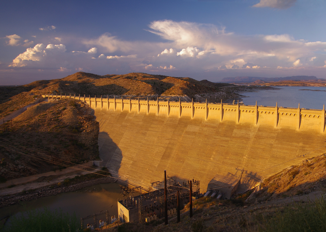
The county includes other communities such as Elephant Butte and Williamsburg, both located near the Rio Grande. Sierra County is well known for Elephant Butte Lake, the state’s largest reservoir, which serves as a major recreation area. Its landscape combines river valleys, desert plateaus, and mountain backdrops, offering both natural resources and outdoor opportunities.
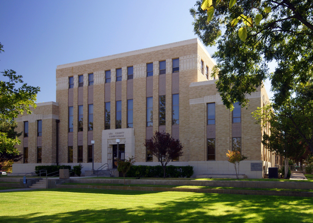
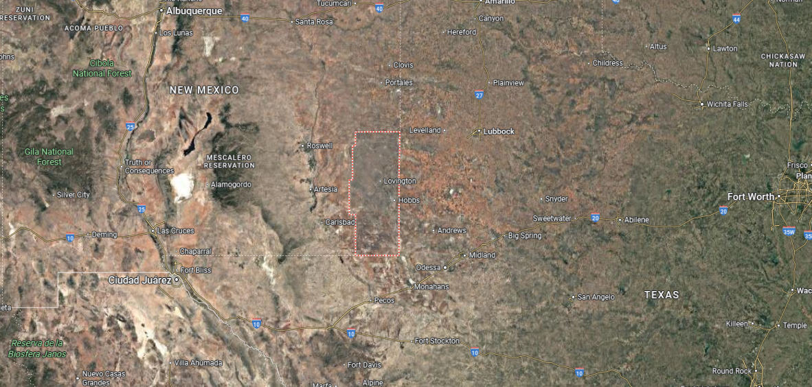
#17. Lea County, New Mexico
– Overall Rank: Not ranked
– Population: 73,103
– Median household income: $65,855
– Median home value: $162,000 (68% own)
– Median rent: $1,031 (32% rent)
– Top public schools: Tatum Junior High School (grade B+), Mills Elementary School (grade B+), Broadmoor Elementary School (grade B+)
– Top private schools: Junction Christian Academy (grade unavailable), St. Helena School (grade unavailable)
– Top places: Lovington (grade B), Hobbs (grade B minus), Eunice (grade B minus)
About
Lea County, New Mexico rests along the state’s southeastern plains, where wide horizons and open land shape both lifestyle and industry. Known for its role in ranching and energy production, the county has long balanced agricultural traditions with oil and natural gas development. Towns and communities carry forward a blend of hard work, independence, and ties to the land.
Community life thrives through fairs, rodeos, and gatherings that reflect its rural character. Residents find recreation in open landscapes, from hunting and horseback riding to local sporting events. Lea County represents a place where industry and tradition meet, sustaining a steady rhythm of resilience and progress.
Where is Lea County?
🔥 Would you like to save this?
Lea County is located in southeastern New Mexico, directly bordering Texas on the east and south. To the north lies Roosevelt County, while Eddy County forms the western boundary. Lovington, the county seat, sits near the center, about 20 miles west of the Texas line.
Hobbs, the largest city, is found in the southeastern part of the county close to the state border. Smaller towns include Jal on the southern edge, Eunice near the southeast corner, and Tatum in the far north. These communities are connected by highways that link Lea County closely with both New Mexico and Texas.
#16. Quay County, New Mexico
– Overall Rank: Not ranked
– Population: 8,641
– Median household income: $38,998
– Median home value: $76,800 (68% own)
– Median rent: $710 (32% rent)
– Top public schools: Logan Elementary School (grade A minus), Logan Middle School (grade A minus), San Jon Elementary School (grade A minus)
– Top places: Tucumcari (grade B minus), San Jon (grade B), Logan (grade C)
About
Quay County, New Mexico lies along the eastern plains, where grasslands stretch wide and the Canadian River carves its path through the landscape. Farming and ranching have long been the backbone of the county, while historic Route 66 adds a layer of cultural identity. Small communities reflect both frontier perseverance and the steady ties of rural living.
Residents gather at county fairs, rodeos, and school-centered events that reinforce close community bonds. Outdoor life blends with history here, offering opportunities to explore trails, rivers, and the landmarks of early travel. Quay County embodies the spirit of the plains—grounded in heritage, shaped by the land, and tied together through enduring traditions.
Where is Quay County?
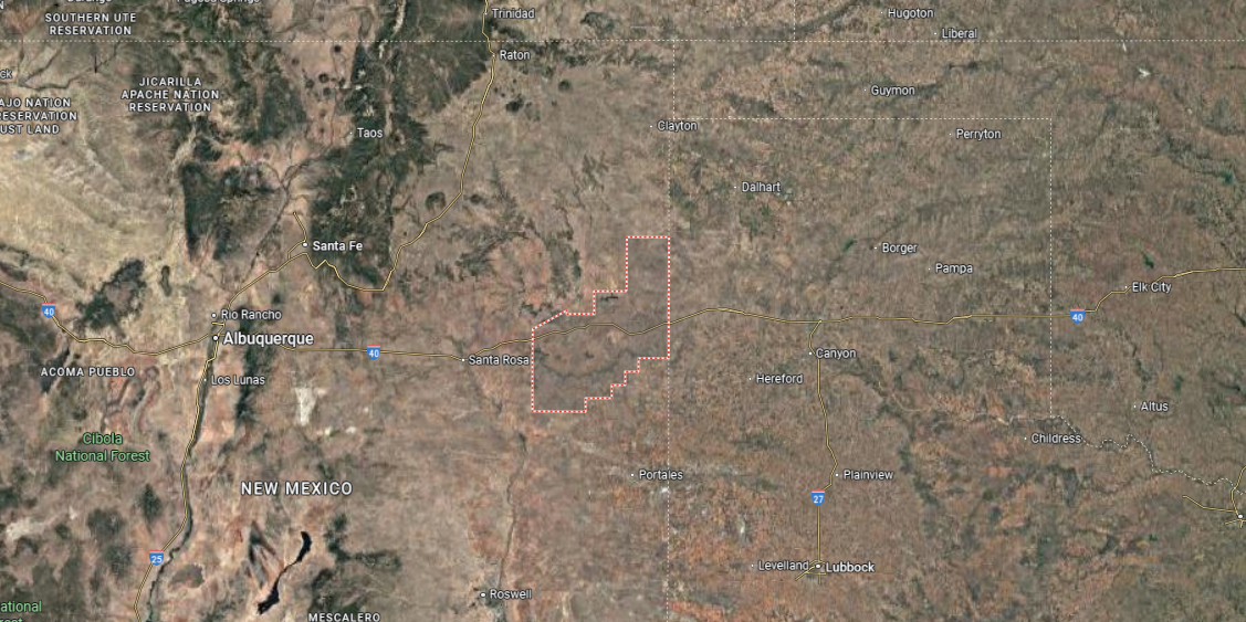
Quay County is in the eastern part of New Mexico, sharing its eastern border with the Texas Panhandle. It covers about 2,900 square miles of plains and mesas and lies along the historic Route 66 corridor. Tucumcari, the county seat, is located near the center of the county along Interstate 40, roughly 115 miles east of Albuquerque.
The county is bordered by Harding and San Miguel counties to the north, Guadalupe County to the west, and Curry and Roosevelt counties to the south. Smaller communities include Logan near Ute Lake, San Jon close to the Texas line, and House in the southern portion. Quay County’s position on major highways makes it a key gateway between New Mexico and Texas.
#15. Taos County, New Mexico
– Overall Rank: Not ranked
– Population: 34,475
– Median household income: $55,145
– Median home value: $313,400 (81% own)
– Median rent: $982 (19% rent)
– Top public schools: Taos Integrated School for the Arts (grade A), Anansi Charter School (grade A minus), Taos Academy (grade A minus)
– Top private schools: Anansi Day School (grade unavailable), UNM Taos Kid’s Campus Center for Early Learning (grade unavailable)
– Top places: Taos (grade B minus), Ranchos de Taos (grade C), Talpa (grade C)
About
Taos County, New Mexico is marked by dramatic mountain ranges, high desert valleys, and the enduring presence of the Rio Grande Gorge. Its identity is deeply tied to Native, Hispanic, and artistic traditions, creating a cultural landscape as layered as its terrain. The town of Taos serves as both a historic center and a gathering place for creative expression.
Outdoor life is woven into daily rhythms, with skiing, hiking, and river exploration shaping connections to the land. Festivals, markets, and cultural events highlight the county’s unique blend of heritage and artistry. Taos County stands as a place where natural beauty and cultural depth continually shape a vibrant, lasting sense of community.
Where is Taos County?
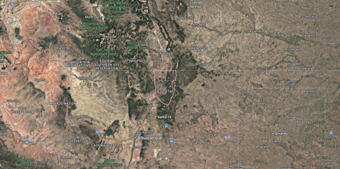
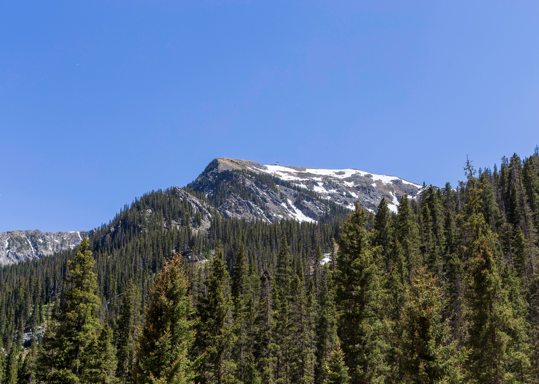
Taos County is located in north-central New Mexico, bordered by Colorado to the north and Rio Arriba County to the west. It stretches across nearly 2,200 square miles of mountains, valleys, and mesas in the southern Rocky Mountains. The county seat, Taos, lies at the base of the Sangre de Cristo Mountains about 70 miles north of Santa Fe.
To the east, Taos County meets Colfax and Mora counties, while its southern boundary connects with Rio Arriba and Mora. Smaller towns such as Questa near the northern edge and Arroyo Seco in the foothills add to the county’s character. Landmarks like Taos Pueblo, the Rio Grande Gorge, and Wheeler Peak highlight the county’s geographic and cultural setting.
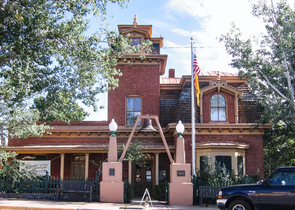
#14. Colfax County, New Mexico
– Overall Rank: 1,395
– Population: 12,370
– Median household income: $46,286
– Median home value: $138,400 (72% own)
– Median rent: $656 (28% rent)
– Top public schools: Cimarron Middle School (grade A minus), Eagle Nest Middle School (grade A minus), Eagle Nest Elementary School (grade B+)
– Top private schools:
– Top places: Raton (grade B minus), Cimarron (grade B), Angel Fire (grade B)
About
Colfax County, New Mexico stretches from sweeping plains to the forested peaks of the Sangre de Cristo Mountains, offering a striking mix of landscapes. Its history is tied to ranching, mining, and the old Santa Fe Trail, which once carried traders and settlers through the region. Small towns and historic sites preserve the echoes of that frontier past.
Today, the county blends outdoor adventure with traditions rooted in community life. Residents and visitors alike enjoy hiking, hunting, and exploring historic landmarks that connect past to present. Colfax County reflects both the rugged independence of its heritage and the enduring bonds of its close-knit communities.
Where is Colfax County?
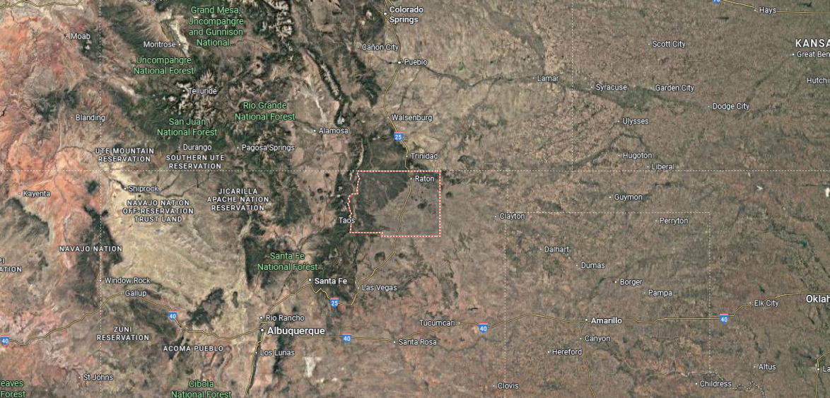
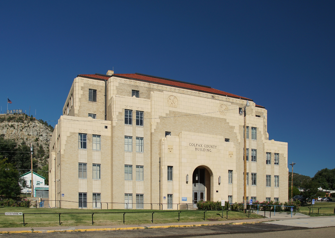
Colfax County sits in the northeastern part of New Mexico, stretching to the Colorado state line on its northern edge. It spans more than 3,700 square miles, with terrain ranging from open plains to the peaks of the Sangre de Cristo Mountains. Raton, the county seat, is located near the Raton Pass along Interstate 25, providing a gateway into Colorado.
The county is bordered by Union County to the east and Taos and Mora counties to the west. Cimarron lies at the foot of the mountains, while Angel Fire and Eagle Nest sit in the Moreno Valley to the south. Colfax County’s location places it at the crossroads of mountain recreation areas, historic trails, and state border travel.
#13. Grant County, New Mexico
– Overall Rank: 1,354
– Population: 28,006
– Median household income: $44,895
– Median home value: $153,900 (71% own)
– Median rent: $802 (29% rent)
– Top public schools: San Lorenzo Elementary School (grade A minus), Cliff Elementary School (grade B+), Jose Barrios Elementary School (grade B)
– Top private schools: Calvary Christian Academy (grade B+), Guadalupe Montessori School (grade unavailable), WNMU Early Childhood Programs (grade unavailable)
– Top places: Santa Clara (grade B minus), Silver City (grade B minus), Bayard (grade B minus)
You may also like: Healthy hotspots: The most physically active counties in New Mexico
About
Grant County, New Mexico is set against the backdrop of mountains, canyons, and high desert plains that define its rugged landscape. Mining has long played a central role in the county’s history, shaping both its economy and its towns. Communities here carry forward a blend of pioneer spirit, cultural heritage, and strong ties to the land.
Local life is enriched by festivals, art scenes, and outdoor opportunities in places like the Gila National Forest. Residents balance work with recreation, finding connection in hiking trails, rivers, and community events. Grant County reflects a heritage of resilience, where history, nature, and culture continue to guide its identity.
Where is Grant County?
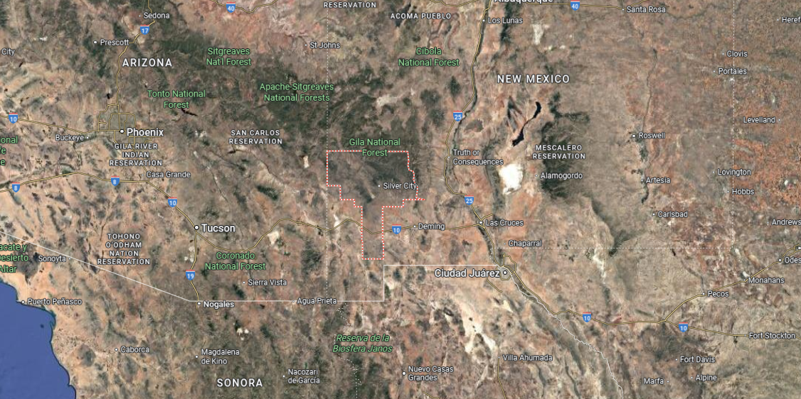
Grant County is in southwestern New Mexico, bordered by Catron County to the north, Luna County to the south, and Hidalgo County to the west. It spans about 3,900 square miles shaped by the Gila Wilderness and nearby mountain ranges. Silver City, the county seat, sits near the center about 45 miles from the Arizona line.
To the east, the county meets Sierra County, while its western edge lies close to Arizona. Communities include Bayard, Hurley, and Santa Clara near Silver City, and Cliff and Gila in the northern river valley. Grant County combines mountains, forests, and desert valleys within its southwestern setting.
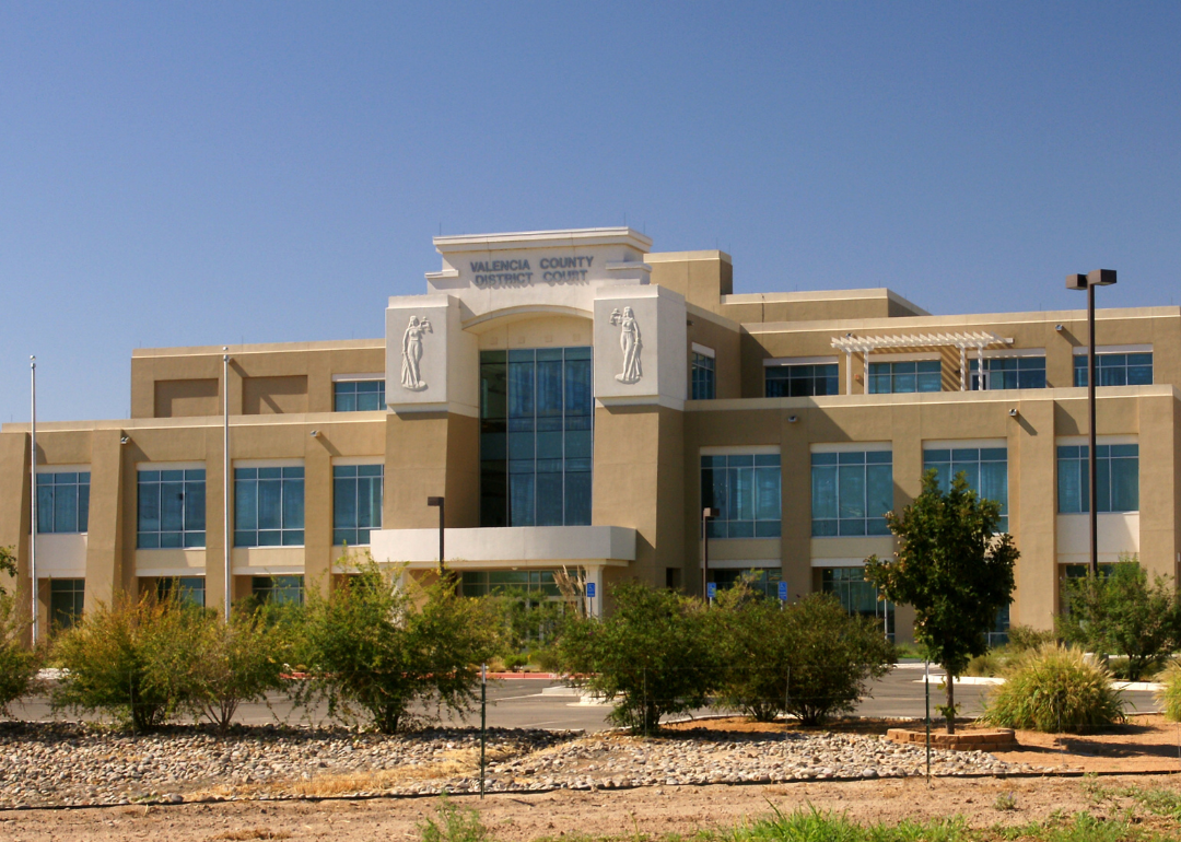
#12. Valencia County, New Mexico
– Overall Rank: 1,349
– Population: 76,613
– Median household income: $56,246
– Median home value: $184,400 (83% own)
– Median rent: $873 (17% rent)
– Top public schools: Katherine Gallegos Elementary School (grade A minus), Bosque Farms Elementary School (grade A minus), Sundance Elementary School (grade A minus)
– Top private schools: Calvary Chapel Academy (grade B minus), St. Mary’s School (grade unavailable)
– Top places: Bosque Farms (grade B), Los Lunas (grade B), Los Chaves (grade B)
About
Valencia County, New Mexico rests along the Rio Grande, where fertile valley lands have supported farming and settlement for generations. Its communities reflect a deep Hispanic heritage, carried forward in traditions, architecture, and shared cultural life. The county also serves as a gateway between rural landscapes and the expanding influence of nearby metropolitan areas.
Daily life is marked by festivals, church gatherings, and markets that strengthen community bonds. Outdoor spaces, from riverbanks to open desert trails, provide recreation and a connection to the land. Valencia County embodies both heritage and change, balancing historic roots with the rhythms of modern growth.
Where is Valencia County?
Valencia County is located in central New Mexico, bordered by Bernalillo County to the north, Torrance County to the east, and Socorro County to the south. It covers about 1,100 square miles, largely within the Rio Grande Valley. Los Lunas, the county seat, lies along Interstate 25 about 25 miles south of Albuquerque.
Other communities include Belen to the south, Bosque Farms to the north, and smaller villages such as Peralta and Meadow Lake. The county’s location along the Rio Grande has long made it a center for farming and settlement. Valencia County also serves as a transition point between the Albuquerque metro area and rural New Mexico to the south.
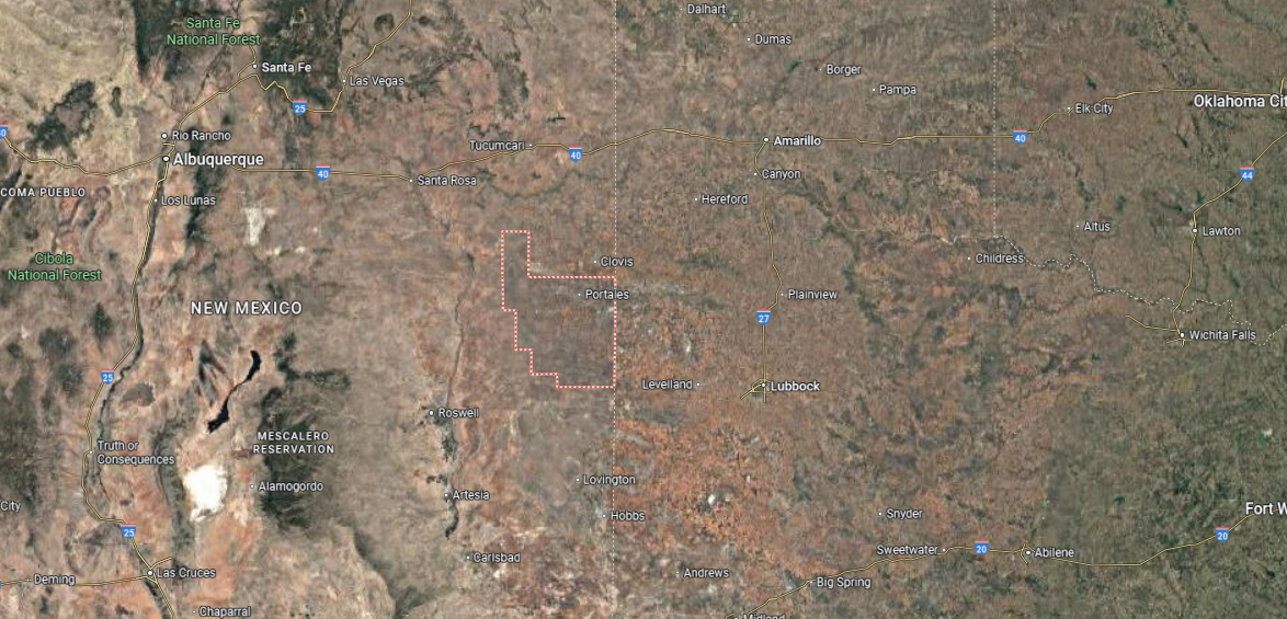
#11. Curry County, New Mexico
– Overall Rank: 1,320
– Population: 48,327
– Median household income: $55,427
– Median home value: $151,300 (59% own)
– Median rent: $956 (41% rent)
– Top public schools: Texico Middle School (grade A), Grady Elementary School (grade A), Melrose Junior High School (grade A)
– Top private schools: Clovis Christian School (grade A minus)
– Top places: Clovis (grade C+), Texico (grade B), Melrose (grade C+)
About
Curry County, New Mexico stretches across the state’s eastern plains, where open farmland and wide skies set the tone of daily life. Agriculture has long anchored the county, with farming and ranching shaping both its economy and traditions. Clovis, the county seat, adds another layer of identity with its role as a regional hub for commerce, culture, and history.
Community rhythms are tied to fairs, rodeos, and school-centered events that reinforce close connections. Outdoor life mixes with history here, from exploring trails and grasslands to celebrating the region’s ties to early Native cultures and pioneering settlers. Curry County reflects a balance of agricultural strength, small-town spirit, and enduring heritage.
Where is Curry County?
🔥 Would you like to save this?
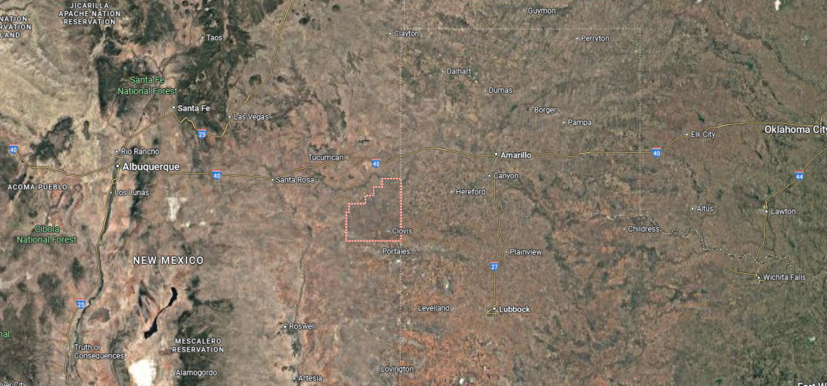
Curry County lies in the eastern part of New Mexico, directly along the Texas state line. It spans just over 1,400 square miles of level plains, forming part of the Llano Estacado. Clovis, the county seat, is located near the center and serves as the region’s main urban hub.
The county is bordered by Quay County to the north, Roosevelt County to the south, and De Baca County to the west. Communities such as Texico on the Texas border and Melrose to the west add to its local network of towns. Curry County’s position makes it both an agricultural center and a gateway between New Mexico and the Texas Panhandle.
#10. Lincoln County, New Mexico
– Overall Rank: 1,212
– Population: 20,222
– Median household income: $47,919
– Median home value: $195,800 (78% own)
– Median rent: $831 (22% rent)
– Top public schools: Capitan Elementary School (grade A minus), Capitan Middle School (grade B+), Capitan High School (grade B+)
– Top places: Ruidoso (grade B minus), Ruidoso Downs (grade B minus), Capitan (grade B+)
About
Lincoln County, New Mexico is steeped in history, where desert hills and pine-covered mountains frame a landscape tied to both ranching and legend. Known for its role in the Lincoln County War and the stories of figures like Billy the Kid, the county preserves a strong sense of the Old West. Its towns blend frontier heritage with the steady rhythms of rural community life.
Modern life here includes ranching, tourism, and outdoor recreation in its forests and valleys. Residents gather for festivals, rodeos, and cultural events that celebrate both history and local traditions. Lincoln County stands as a place where past and present meet, carrying forward the enduring spirit of the Southwest.
Where is Lincoln County?
Lincoln County is located in south-central New Mexico, bordered by Torrance and Guadalupe counties to the north and Otero County to the south. It covers more than 4,800 square miles of mountains, valleys, and desert basins. Carrizozo, the county seat, sits near the center along U.S. Highways 54 and 380.
The county includes the mountain town of Ruidoso in the Sierra Blanca range, as well as Capitan, known as the birthplace of Smokey Bear. To the east lie smaller communities such as Hondo and Corona, while White Oaks sits to the north as a historic mining town. Lincoln County’s varied setting ties together mountain forests, ranching areas, and historic landmarks of the Old West.
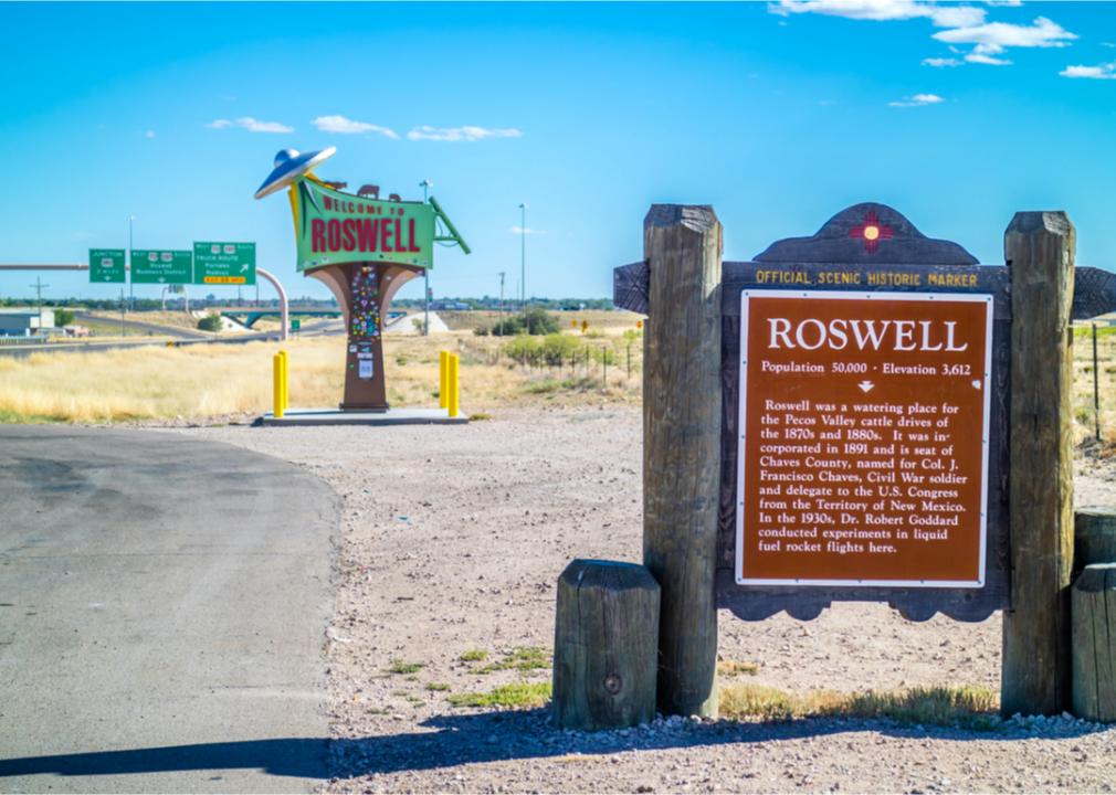
#9. Chaves County, New Mexico
– Overall Rank: 1,073
– Population: 64,701
– Median household income: $49,673
– Median home value: $133,200 (67% own)
– Median rent: $850 (33% rent)
– Top public schools: Early College High School (grade A minus), Sidney Gutierrez Middle School (grade A minus), New Mexico Military Institute (grade B+)
– Top private schools: Gateway Christian School (grade B+), All Saints Catholic School of Roswell (grade unavailable), Immanuel Lutheran School (grade unavailable)
– Top places: Roswell (grade B minus), Hagerman (grade B minus), Lake Arthur (grade C+)

About
Chaves County, New Mexico stretches across fertile plains where agriculture has long been central to its economy and way of life. The county seat, Roswell, adds a distinctive layer of identity with its history, ranching roots, and reputation as a center of trade and culture. Generations of families have shaped the county through farming, civic life, and community traditions.
Daily rhythms are enriched by festivals, fairs, and gatherings that strengthen local ties. Residents and visitors alike find space for recreation in parks, trails, and open landscapes that highlight the county’s natural character. Chaves County reflects a balance of heritage and progress, grounded in its agricultural base while embracing its evolving role in New Mexico’s story.
Where is Chaves County?
Chaves County is in southeastern New Mexico, bordered by De Baca County to the north, Lea County to the east, and Eddy County to the south. It spans more than 6,000 square miles of plains and river valleys. Roswell, the county seat, lies near the center along the Pecos River and serves as the county’s largest city.
To the west, Chaves County connects with Lincoln and Otero counties, creating a link between the plains and mountain foothills. Smaller communities include Hagerman to the south, Dexter to the southeast, and Lake Arthur near the Lea County line. The county’s geography blends farmland, ranchland, and river corridors, with Roswell standing as its central hub.
#8. Roosevelt County, New Mexico
– Overall Rank: 977
– Population: 19,142
– Median household income: $52,644
– Median home value: $128,100 (60% own)
– Median rent: $795 (40% rent)
– Top public schools: Dora High School (grade A), Dora Elementary School (grade A minus), Floyd Middle School (grade B+)
– Top private schools: Eastern New Mexico University Child Development Center Laboratory (grade unavailable)
– Top places: Portales (grade B), Elida (grade B minus), Floyd (grade unavailable)
You may also like: Beef steaks, white bread, and other groceries that dropped in price in the West last month
About
Roosevelt County, New Mexico rests on the state’s eastern plains, where open fields and far-reaching skies define both the land and its communities. Farming and ranching have long anchored the county’s identity, with agriculture continuing to sustain local families and traditions. Portales, the county seat, serves as both an educational hub and cultural center for the region.
Life here is marked by close-knit gatherings, from county fairs to school events that bring neighbors together. Outdoor activities, including hunting, hiking, and exploring the plains, keep residents connected to the land. Roosevelt County reflects a steady rhythm of rural life, rooted in heritage while shaped by the enduring spirit of its people.
Where is Roosevelt County?
Roosevelt County is situated in eastern New Mexico, bordering Texas to the east and Curry County to the north. It covers about 2,400 square miles of flat plains that form part of the Llano Estacado. Portales, the county seat, lies near the center of the county and serves as its largest community.
To the west, Roosevelt County meets De Baca County, while to the south it connects with Lea and Chaves counties. Smaller towns include Dora in the south and Elida to the southwest. The county’s location places it within an agricultural region, closely tied to both ranching and farming across the High Plains.
#7. Otero County, New Mexico
– Overall Rank: 939
– Population: 67,850
– Median household income: $50,833
– Median home value: $139,100 (66% own)
– Median rent: $882 (34% rent)
– Top public schools: Cloudcroft Elementary School (grade A minus), Cloudcroft Middle School (grade A minus), Holloman Middle School (grade A minus)
– Top private schools: Imago Dei Academy (grade A), Legacy Christian Academy (grade unavailable), Father James B. Hay School (grade unavailable)
– Top places: La Luz (grade B+), Alamogordo (grade B+), Boles Acres (grade B minus)
About
Otero County, New Mexico stretches from the White Sands to the Sacramento Mountains, offering a striking contrast of desert and forested highlands. Its history is tied to ranching, timber, and the presence of military installations that have shaped both its economy and identity. Communities balance small-town life with access to some of the state’s most iconic landscapes.
Recreation defines much of local living, with opportunities for hiking, camping, and exploring unique places like White Sands National Park. Festivals, markets, and cultural gatherings add rhythm to community life while honoring deep-rooted traditions. Otero County embodies both natural wonder and resilience, where heritage and landscape continue to guide its character.
Where is Otero County?
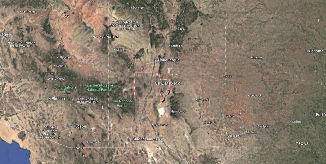
Otero County is in south-central New Mexico, bordered by Lincoln County to the north, Chaves and Eddy counties to the east, and Doña Ana County to the west. It spans more than 6,600 square miles, making it one of the state’s largest counties. Alamogordo, the county seat, sits along the western edge of the Sacramento Mountains near U.S. Highway 54.
The county reaches the Texas border to the south, where it connects with Hudspeth and El Paso counties. Other communities include Cloudcroft high in the Sacramento Mountains and Tularosa in the northern Rio Grande Basin. Otero County is marked by contrasting landscapes, from White Sands National Park to forested mountain terrain.
#6. Sandoval County, New Mexico
– Overall Rank: 908
– Population: 149,460
– Median household income: $76,424
– Median home value: $258,100 (81% own)
– Median rent: $1,280 (19% rent)
– Top public schools: Mountain View Middle School (grade A), Martin Luther King Jr. Elementary School (grade A), Enchanted Hills Elementary School (grade A)
– Top private schools: Sandia View Academy (grade A minus), Gospel Light Baptist Academy (grade B), St. Thomas Aquinas School (grade unavailable)
– Top places: Corrales (grade A minus), Rio Rancho (grade A minus), Placitas (grade A minus)
🔥 Would you like to save this?
About
Sandoval County, New Mexico is defined by its diverse landscapes, from desert mesas to forested mountains, and by the Rio Grande that cuts through its heart. Its communities reflect a mix of Pueblo traditions, Hispanic heritage, and modern growth tied to nearby Albuquerque. Historic sites, pueblos, and small towns keep cultural depth alive alongside expanding suburban areas.
Life here blends tradition with recreation, offering trails, rivers, and open spaces for daily connection to the land. Festivals, art markets, and cultural gatherings highlight the county’s rich blend of history and community pride. Sandoval County represents a meeting point of heritage and progress, where varied cultures and landscapes shape a dynamic identity.
Where is Sandoval County?
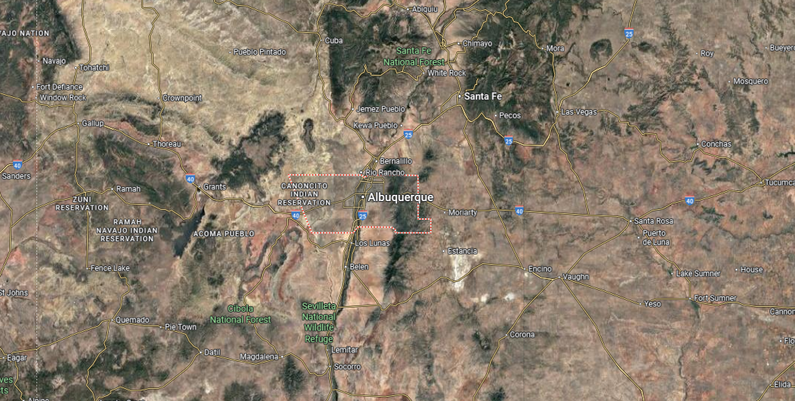
Sandoval County is located in north-central New Mexico, bordered by Rio Arriba County to the north, Santa Fe County to the east, and McKinley County to the west. It spans over 3,700 square miles, with landscapes ranging from desert plateaus to the Jemez Mountains. Bernalillo, the county seat, sits just north of Albuquerque along Interstate 25.
The county includes communities such as Rio Rancho, its largest city, as well as Jemez Springs, Cuba, and Corrales. It borders the Rio Grande through its central corridor, linking rural areas with fast-growing suburbs. Sandoval County’s location places it at the meeting point of metropolitan growth, historic pueblos, and mountain wilderness.
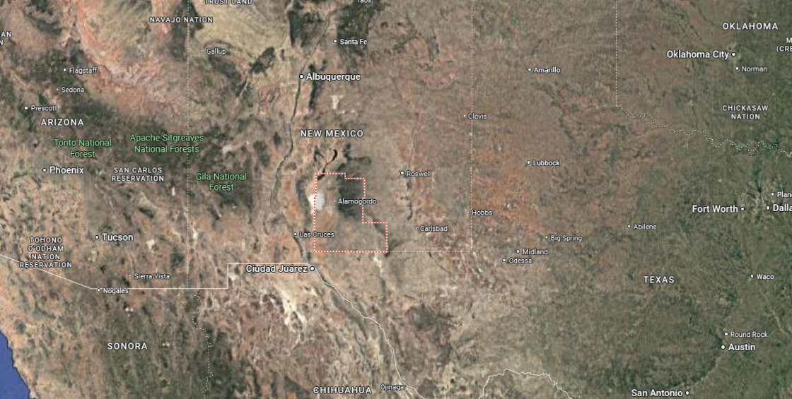
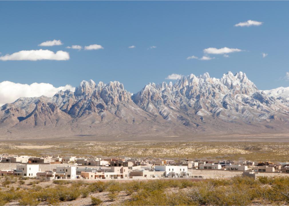
#5. Doña Ana County, New Mexico
– Overall Rank: 593
– Population: 219,870
– Median household income: $51,232
– Median home value: $187,400 (64% own)
– Median rent: $858 (36% rent)
– Top public schools: Arrowhead Park Early College High School (grade A+), J. Paul Taylor Academy (grade A minus), White Sands Elementary School (grade A minus)
– Top private schools: Las Cruces Catholic School (grade A), Mesilla Valley Christian School (grade A minus), Mission Lutheran School (grade unavailable)
– Top places: Mesilla (grade A minus), Las Cruces (grade A minus), Santa Teresa (grade B+)
About
Doña Ana County, New Mexico lies along the Rio Grande Valley, where fertile land has supported farming and settlement for centuries. Its identity reflects a deep Hispanic heritage, Native traditions, and the influence of trade routes that once linked communities across the Southwest. Las Cruces, the county seat, serves as both an agricultural hub and a center of education and culture.
Daily life includes festivals, markets, and gatherings that celebrate food, music, and long-standing traditions. Residents and visitors alike enjoy access to nearby desert trails, mountains, and the flowing Rio Grande for recreation. Doña Ana County embodies a balance of heritage and growth, rooted in its land while open to change and new opportunity.
Where is Doña Ana County?
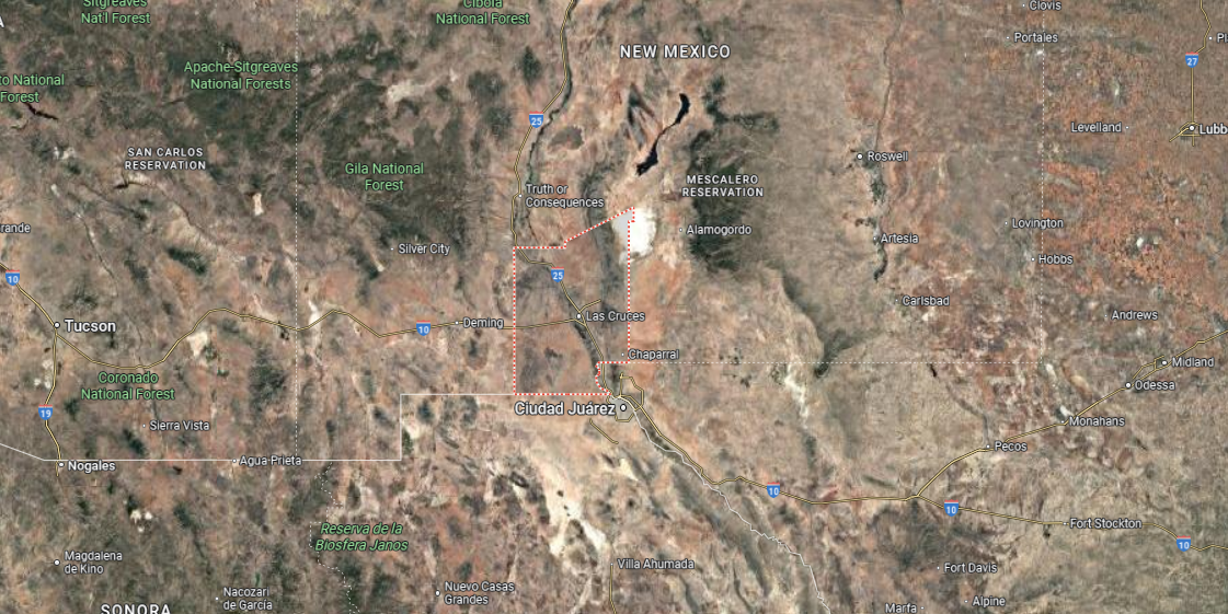
Doña Ana County is in south-central New Mexico, bordered by Sierra County to the north, Otero County to the east, and Texas to the south and southeast. It also touches the international boundary with Mexico, making it a tri-border region of unique importance. The county spans over 3,800 square miles, with Las Cruces, the county seat and second-largest city in New Mexico, located along the Rio Grande.
Other communities include Mesilla, known for its historic plaza, Anthony on the Texas border, and Hatch to the north, famous for its chile crops. The county’s terrain ranges from the fertile Rio Grande Valley to the rugged Organ Mountains rising east of Las Cruces. Doña Ana County’s location ties together international, interstate, and regional connections within the Mesilla Valley.
#4. Eddy County, New Mexico
– Overall Rank: 475
– Population: 61,264
– Median household income: $77,458
– Median home value: $188,400 (73% own)
– Median rent: $1,095 (27% rent)
– Top public schools: Carlsbad Early College High School (grade A), Artesia Zia Intermediate School (grade A), Yeso Elementary School (grade A)
– Top private schools:
– Top places: Artesia (grade A minus), Atoka (grade B minus), Carlsbad (grade B minus)
About
Eddy County, New Mexico is shaped by the Pecos River, wide desert lands, and the underground wonders of Carlsbad Caverns. Agriculture and ranching first anchored its economy, later joined by oil and gas development that continue to play a central role today. Carlsbad and Artesia serve as hubs of commerce, culture, and community life within the county.
Outdoor life defines much of its character, from exploring caverns and riverbanks to enjoying festivals and rodeos that bring people together. The blend of natural landmarks and industry gives the county a distinct rhythm rooted in both land and labor. Eddy County reflects resilience and resourcefulness, carrying forward traditions while adapting to modern growth.
Where is Eddy County?
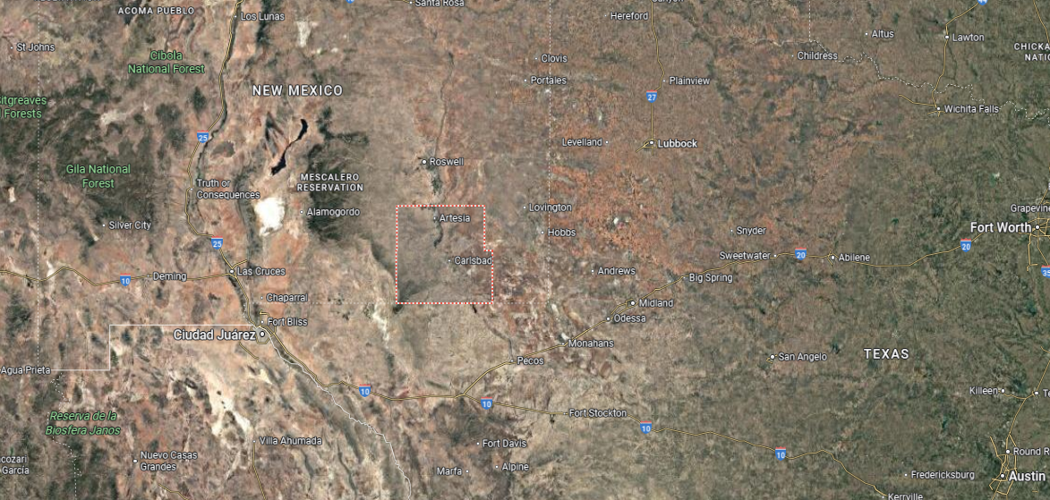
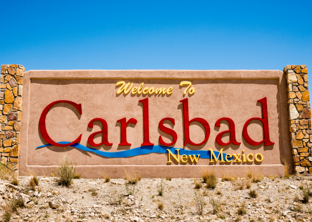
Eddy County is located in southeastern New Mexico, bordered by Chaves County to the north, Lea County to the east, and Otero County to the west. Its southern edge meets the Texas state line, creating a direct connection to the Permian Basin region. The county covers more than 4,100 square miles, with Carlsbad serving as the county seat along the Pecos River.
Other communities include Artesia to the north and Loving near the southern border with Texas. The county is notable for natural landmarks such as Carlsbad Caverns National Park and the Pecos River Valley. Eddy County’s location links New Mexico’s desert landscapes with one of the nation’s most important oil- and gas-producing areas.
#3. Santa Fe County, New Mexico
– Overall Rank: 464
– Population: 154,481
– Median household income: $70,522
– Median home value: $374,200 (72% own)
– Median rent: $1,252 (28% rent)
– Top public schools: Mandela International Magnet School (grade A), Academy for Technology & the Classics (grade A), The MASTERS Program (grade A)
– Top private schools: Santa Fe Preparatory School (grade A+), St. Michael’s High School (grade A), Fayette Street Academy (grade A)
– Top places: Eldorado at Santa Fe (grade B+), Pojoaque (grade B+), Edgewood (grade B+)
You may also like: The top careers hiring for AI skills in New Mexico, according to job postings

About
Santa Fe County, New Mexico is anchored by the state capital, where adobe architecture, historic plazas, and mountain backdrops define a unique cultural landscape. Its history is layered with Native traditions, Spanish colonial heritage, and a long-standing role as a crossroads of trade and art. Beyond the city, rural villages and open high desert maintain ties to farming, ranching, and community traditions.
Life here blends the old and the new, with art markets, festivals, and spiritual traditions coexisting alongside modern growth. Trails, mountains, and rivers provide daily access to recreation and natural beauty. Santa Fe County reflects both heritage and creativity, offering a lasting sense of place shaped by history, culture, and landscape.
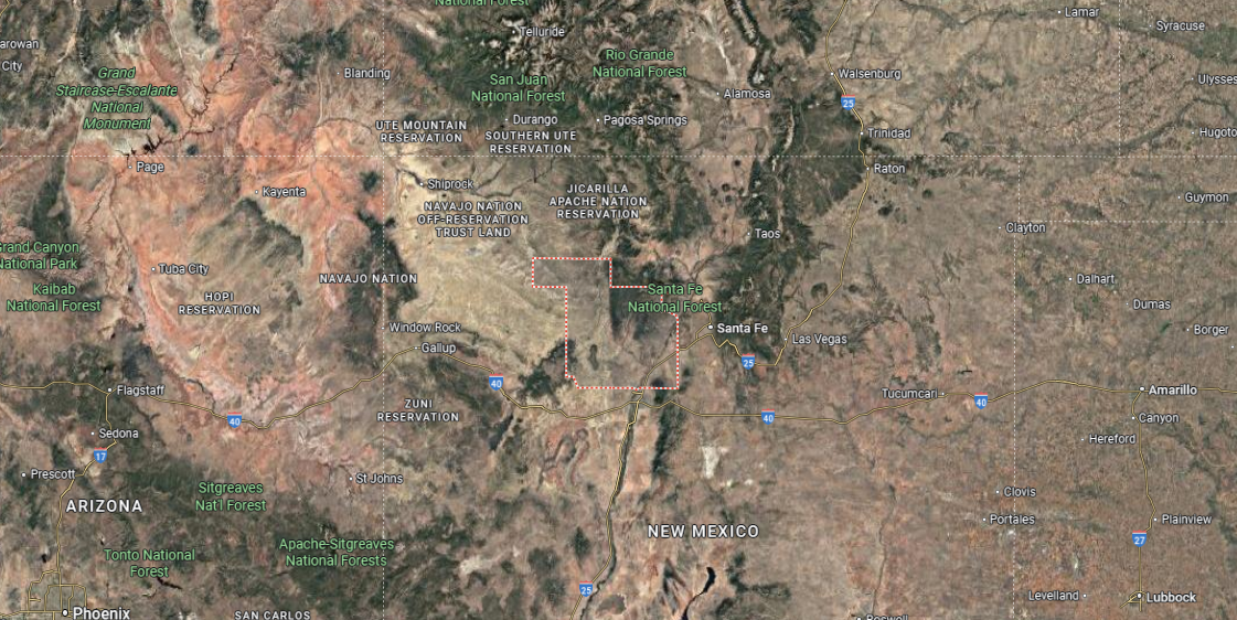
Where is Santa Fe County?
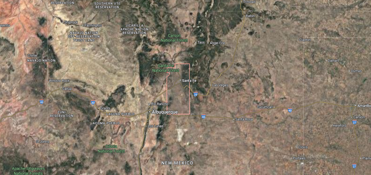
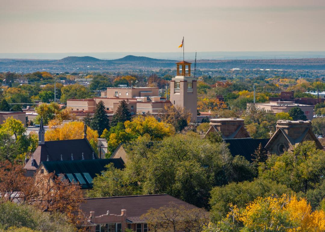
Santa Fe County is in north-central New Mexico, bordered by Rio Arriba County to the north, San Miguel County to the east, and Bernalillo County to the south. It covers about 1,900 square miles, with varied landscapes that include high desert, forested mountains, and the upper Rio Grande Valley. Santa Fe, the county seat and state capital, lies at the base of the Sangre de Cristo Mountains about 60 miles north of Albuquerque.
Other communities include Edgewood on the eastern plains, Tesuque just north of the city, and Eldorado to the south. The county is surrounded by historic pueblos and national forest lands that shape its cultural and geographic identity. Santa Fe County’s location places it at the crossroads of New Mexico’s political, artistic, and historic heart.
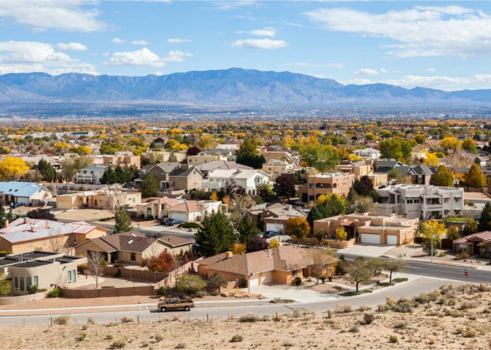
#2. Bernalillo County, New Mexico
– Overall Rank: 338
– Population: 674,692
– Median household income: $62,220
– Median home value: $247,300 (63% own)
– Median rent: $1,017 (37% rent)
– Top public schools: Nex+Gen Academy (grade A+), East Mountain High School (grade A+), La Cueva High School (grade A+)
– Top private schools: Albuquerque Academy (grade A+), Sandia Preparatory School (grade A+), Menaul School (grade A+)
– Top places: Sandia Heights (grade A+), Nob Hill (grade A+), Eastside (grade A)
About
Bernalillo County, New Mexico centers on Albuquerque, the state’s largest city, where the Rio Grande and the Sandia Mountains frame a dynamic urban landscape. Its history reflects Pueblo traditions, Spanish settlement, and the growth of trade routes that established the region as a cultural and economic hub. The county combines metropolitan energy with deep cultural roots that remain visible in architecture, festivals, and community life.
Recreation and tradition meet in its trails, riverbanks, and the iconic International Balloon Fiesta that draws visitors worldwide. Neighborhoods, markets, and local gatherings reflect both diversity and strong community ties. Bernalillo County stands as a place where history and modern life converge, shaping a vibrant identity for New Mexico’s heart.
Where is Bernalillo County?
#1. Los Alamos County, New Mexico
– Overall Rank: 2
– Population: 19,253
– Median household income: $135,801
– Median home value: $412,700 (73% own)
– Median rent: $1,235 (27% rent)
– Top public schools: Los Alamos High School (grade A), Mountain Elementary School (grade A), Barranca Mesa Elementary School (grade A)
– Top private schools: Ponderosa Montessori School (grade unavailable), Canyoncito Montessori School & Child Care Center (grade unavailable)
– Top places: Los Alamos (grade A+), White Rock (grade A+)
About
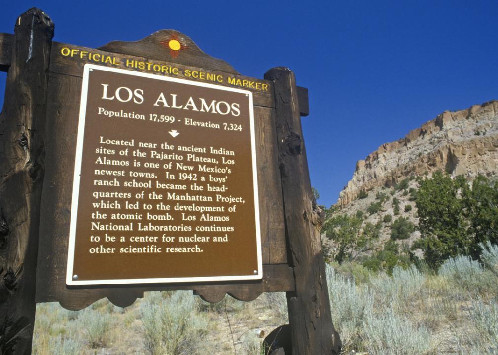
Los Alamos County, New Mexico rests atop the Pajarito Plateau, surrounded by mesas, canyons, and the nearby Jemez Mountains. Its identity is closely tied to science and innovation, shaped by the Manhattan Project and the continued presence of Los Alamos National Laboratory. At the same time, the area maintains a connection to natural beauty, with landscapes that provide both history and escape.
Residents enjoy a balance of intellectual life and outdoor activity, with hiking, skiing, and trail exploration part of the community rhythm. Cultural events, educational programs, and local gatherings reinforce a sense of shared purpose. Los Alamos County reflects a rare blend of scientific achievement, natural wonder, and community strength.
Where is Los Alamos County?
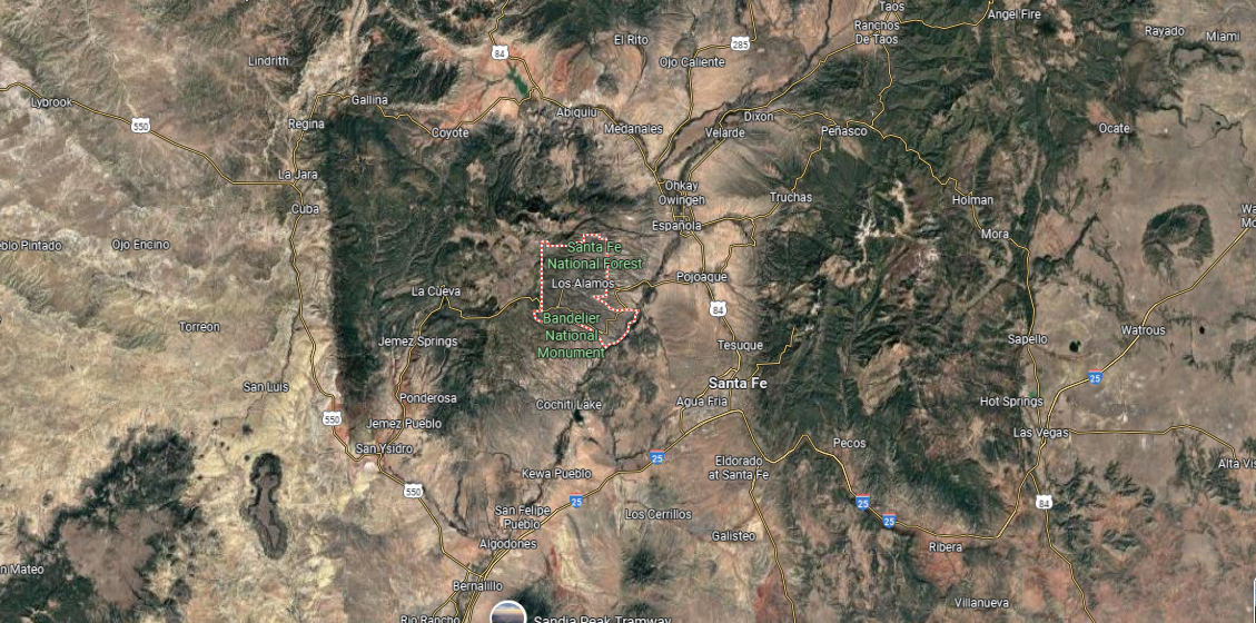
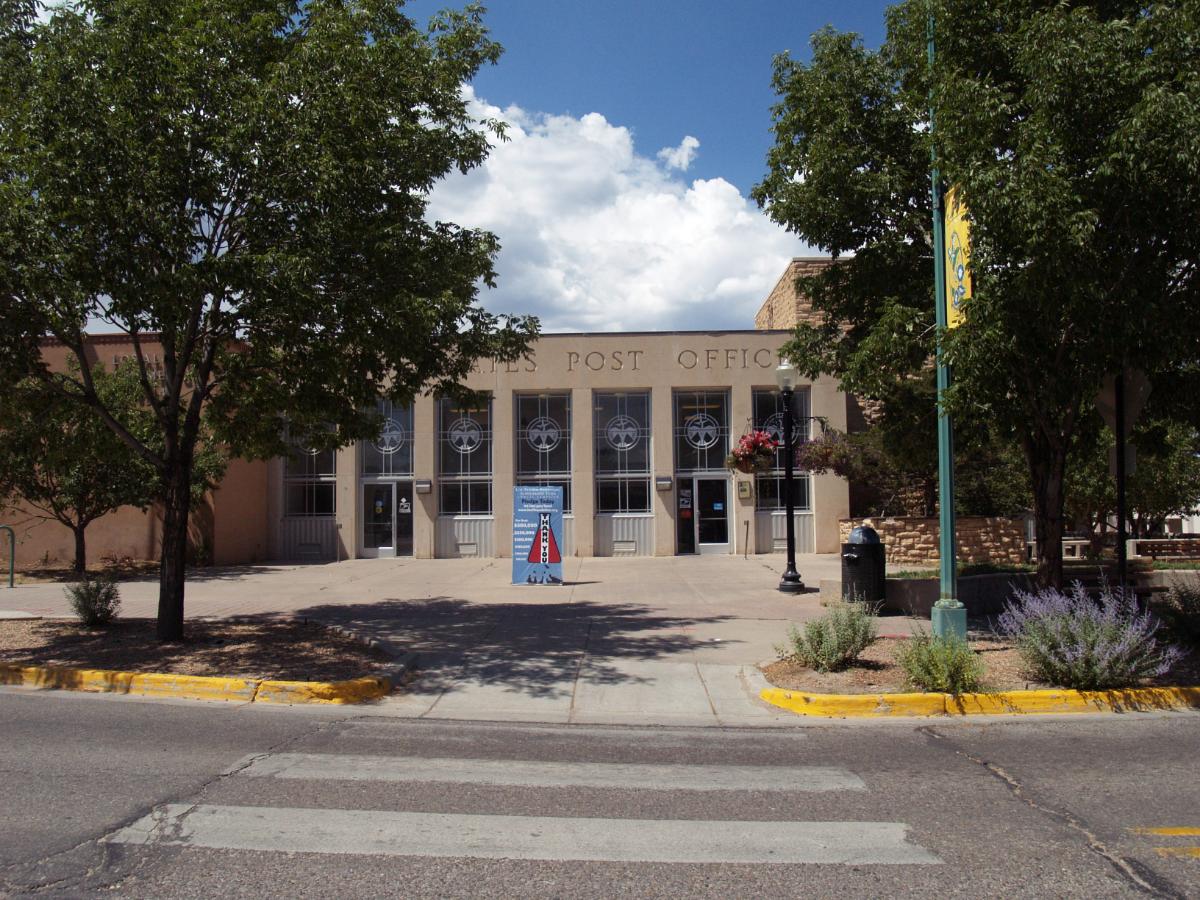
Los Alamos County is in north-central New Mexico, bordered by Rio Arriba County to the north and Sandoval County to the south and west. It is one of the smallest counties in the state, covering just over 100 square miles on the Pajarito Plateau. Los Alamos, the county seat, is located on a series of mesas overlooking the Rio Grande Valley.
The county lies about 35 miles northwest of Santa Fe and is surrounded by national forest and federal lands. White Rock, the other main community, sits on the southeastern edge near the canyon country of the Rio Grande. Los Alamos County’s location combines mountain terrain, cultural history, and proximity to New Mexico’s high desert landscapes.
This story features data reporting and writing by Elena Cox and is part of a series utilizing data automation across 50 states.
By Stacker


